a treasure-trove of literature
treasure found hidden with no evidence of ownership
(and our other authors) or get HELP Reading, Downloading and Converting files)
or
SEARCH the entire site with Google Site Search
|
Project Gutenberg
Australia a treasure-trove of literature treasure found hidden with no evidence of ownership |
BROWSE the site for other works by this author (and our other authors) or get HELP Reading, Downloading and Converting files) or SEARCH the entire site with Google Site Search |
Title: The First Journey to the South Magnetic Pole.
Author: T. W. Edgeworth David; edited by Ned Overton.
* A Project Gutenberg of Australia eBook *
eBook No.: 1402771h.html
Language: English
Date first posted: October 2014.
Date most recently updated: October 2014.

Produced by: Ned Overton.

Project Gutenberg Australia eBooks are created from printed editions
which are in the public domain in Australia, unless a copyright notice
is included. We do NOT keep any eBooks in compliance with a particular
paper edition.

Copyright laws are changing all over the world. Be sure to check the
copyright laws for your country before downloading or redistributing this
file.

This eBook is made available at no cost and with almost no restrictions
whatsoever. You may copy it, give it away or re-use it under the terms
of the Project Gutenberg Australia Licence which may be viewed online.
GO TO Project Gutenberg Australia HOME PAGE
Production Notes:
Edgeworth David's account—a book within a book, namely
Chapters VI-XIII of Volume II of Ernest Shackleton's "Heart of
the Antarctic" [also in Project Gutenberg Australia]—is
here given an independent existence. The map is from the
Geographical Journal of the Royal Geographic Society.
David, Deputy Leader of the British Antarctic Expedition of
1907-09, led the party which not only attained the Magnetic Pole
but also first ascended Mt Erebus. David gave no account of the
Erebus ascent, so no mention is made here. Several appendices,
co-authored by David or written by Mawson, are included to throw
light on the scientific roles of the exploration party
members.
Although all the exploration recorded in "Heart" was carried out
under the auspices of the British Antarctic Expedition (1907-09),
the successes of David's party must have played a significant
part in initiating Australia's continuing role in the Antarctic,
from 1911 to the present, with Douglas Mawson as a parent.
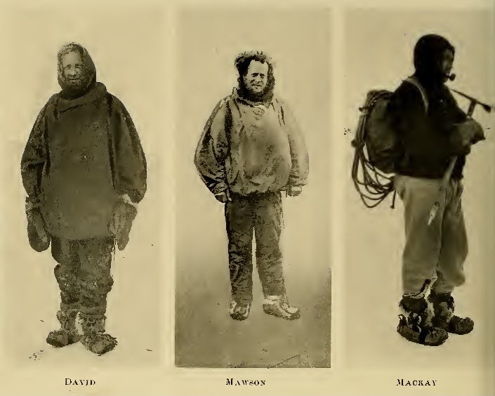
1. The Northern Party at the South
Magnetic Pole
From Left—Dr. Mackay, Professor David, Douglas
Mawson
(Frontispiece)
Published November, 1909
Printed by J. B. Lippincott Company
The Washington Square Press, Philadelphia, U.S.A.
{Page vii}
[* To "Heart of the Antarctic" by E. H. Shackleton, 1909; 2 vols.]
THE scientific results of the expedition* cannot be stated in detail in this book. The expert members in each branch have contributed to the appendices articles which summarise what has been done in the domains of geology, biology, magnetism, meteorology, physics, &c. I will simply indicate here some of the more important features of the geographical work.
[* The British Antarctic Expedition of 1907-09.—Ed.]
We passed the winter of 1908 in McMurdo Sound, twenty miles north of the Discovery winter quarters. In the autumn a party** ascended Mount Erebus and surveyed its various craters. In the spring and summer of 1908-9 three sledging-parties left winter quarters; one went south and attained the most southerly latitude ever reached by man, another reached the South Magnetic Pole** for the first time, and a third surveyed the mountain ranges west of McMurdo Sound.
[** The same party of three, viz. David, Mackay and Mawson. In the Erebus ascent, they were supported by Adams, Marshall and Brocklehurst.—Ed.]
The southern sledge-journey planted the Union Jack in latitude 88° 23' South, within one hundred geographical miles of the South Pole. This party of four ascertained that a great chain of mountains extends from the 82nd parallel, south of McMurdo Sound, to the 86th parallel, trending in a south-easterly direction; that other great mountain ranges continue to the south and south-west, and that between them flows one of the largest glaciers in the world, leading to an inland plateau, the height of which, at latitude 88° South, is over 11,000 ft. above sea-level. This plateau presumably continues beyond the geographical South Pole, and extends from Cape Adare to the Pole. The bearings and angles of the new southern mountains and of the great glacier are shown on the chart, and are as nearly correct as can be expected in view of the somewhat rough methods necessarily employed in making the survey.
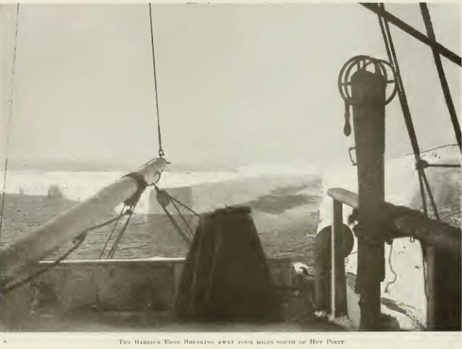
The mystery of the Great Ice Barrier has not been solved, and it would seem that the question of its formation and extent cannot be determined definitely until an expedition traces the line of the mountains round its southerly edge. A certain amount of light has been thrown on the construction of the Barrier, in that we were able, from observations and measurements, to conclude provisionally that it is composed mainly of snow. The disappearance of Balloon Bight, owing to the breaking away of a section of the Great Ice Barrier, shows that the Barrier still continues its recession, which has been observed since the voyage of Sir James Ross in 1842. There certainly appears to be a high snow-covered land on the 163rd meridian, where we saw slopes and peaks, entirely snow-covered, rising to a height of 800 ft., but we did not see any bare rocks, and did not have an opportunity to take soundings at this spot. We could not arrive at any definite conclusion on the point.
The journey made by the Northern Party* resulted in the attainment of the South Magnetic Pole, the position of which was fixed, by observations made on the spot and in the neighbourhood, at latitude 72° 25' South, longitude 155° 16' East. The first part of this journey was made along the coastline of Victoria Land, and many new peaks, glaciers and ice-tongues were discovered, in addition to a couple of small islands. The whole of the coast traversed was carefully triangulated, and the existing map was corrected in several respects.
[* David, Mackay and Mawson are referred to throughout "Heart" as "The Northern Party".—Ed.]
The survey of the western mountains by the Western Party added to the information of the topographical details of that part of Victoria Land, and threw some new light on its geology.
The discovery of forty-five miles of new coastline extending from Cape North, first in a south-westerly and then in a westerly direction, was another important piece of geographical work.
During the homeward voyage of the Nimrod a careful search strengthened that prevalent idea that Emerald Island, the Nimrod Islands and Dougherty Island do not exist, but I would not advise their removal from the chart without further investigation. There is a remote possibility that they lie at some point in the neighbourhood of their charted positions, and it is safer to have them charted until their non-existence has been proved absolutely.
I should like to tender my warmest thanks to those generous people who supported the expedition in its early days. Miss Dawson Lambton and Miss E. Dawson Lambton made possible the first steps towards the organisation of the expedition, and assisted afterwards in every way that lay in their power. Mr. William Beardmore (Parkhead, Glasgow), Mr. G. A. McLean Buckley (New Zealand), Mr. Campbell McKellar (London), Mr. Sydney Lysaght (Somerset), Mr. A. M. Fry (Bristol), Colonel Alexander Davis (London), Mr. William Bell (Pendell Court, Surrey), Mr. H. H. Bartlett (London), and other friends contributed liberally towards the cost of the expedition. I wish also to thank the people who guaranteed a large part of the necessary expenditure, and the Imperial Government for the grant of £20,000, which enabled me to redeem these guarantees. Sir James Mills, managing director of the Union Steam Shipping Company of New Zealand, gave very valuable assistance. The kindness and generosity of the Governments and people of Australia and New Zealand will remain one of the happiest memories of the expedition.
I am also indebted to the firms which presented supplies of various sorts, and to the manufacturers who so readily assisted in the matter of ensuring the highest quality and purity in our foods.
As regards the production of this book, I am indebted to Dr. Hugh Robert Mill for the introduction which he has written; to Mr. Edward Saunders, of New Zealand, who not only acted as my secretary in the writing of the book, but bore a great deal of the labour, advised me on literary points and gave general assistance that was invaluable; and to my publisher, Mr. William Heinemann, for much help and many kindnesses.
I have to thank the members of the expedition who have provided the scientific appendices. I should like to make special mention of Professor T. W. Edgeworth David, who has told the story of the Northern Journey, and Mr. George Marston, the artist of the expedition, represented in this volume by the colour plates, sketches and some diagrams.
I have drawn on the diaries of various members of the expedition to supply information regarding events that occurred while I was absent on journeys. The photographs with which these volumes are illustrated have been selected from some thousands taken by Brocklehurst, David, Davis, Day, Dunlop, Harbord, Joyce, Mackintosh, Marshall, Mawson, Murray and Wild, secured often under circumstances of exceptional difficulty.
In regard to the management of the affairs of the expedition during my absence in the Antarctic, I would like to acknowledge the work done for me by my brother-in-law, Mr. Herbert Dorman, of London; by Mr. J. J. Kinsey, of Christchurch, New Zealand; and by Mr. Alfred Reid, the manager of the expedition, whose work throughout has been as arduous as it has been efficient.
Finally, let me say that to the members of the expedition, whose work and enthusiasm have been the means of securing the measure of success recorded in these pages, I owe a debt of gratitude that I can hardly find words to express. I realise very fully that without their faithful service and loyal co-operation under conditions of extreme difficulty success in any branch of our work would have been impossible.
Ernest H. Shackleton
London,
October 1909
Preface
Chapter One
Chapter Two
Chapter Three
Chapter Four
Chapter Five
Chapter Six
Chapter Seven
Chapter Eight
Appendix
I: GEOLOGICAL OBSERVATIONS.
I.1: GEOLOGICAL OBSERVATIONS IN
ANTARCTICA BY THE BRITISH ANTARCTIC EXPEDITION. 1907-1909. BY
PROFESSOR T. W. EDGEWORTH DAVID. B.A., F.R.S. AND RAYMOND E.
PRIESTLEY, GEOLOGIST TO THE EXPEDITION
I.2: NOTES IN REGARD TO MOUNT EREBUS.
BY PROFESSOR T. W. EDGEWORTH DAVID AND RAYMOND
PRIESTLEY
Appendix
II: NOTES ON PHYSICS, CHEMISTRY AND
MINERALOGY.
II.1: ICE AND SNOW. NOTES BY DOUGLAS
MAWSON, B.Sc., B.E.
II.2: MINERALOGY AND CHEMISTRY. NOTES
BY DOUGLAS MAWSON. B.Sc., B.E.
II.3: METEOROLOGICAL OPTICS. NOTES BY
DOUGLAS MAWSON, B.Sc., B.E.
II.4: MAGNETIC OBSERVATIONS. THE
MAGNETIC POLE AND THE AURORA. NOTES BY DOUGLAS MAWSON. B.Sc.,
B.E.
Appendix
III: METEOROLOGY.
III.1: A SUMMARY OF RESULTS. BY
PROFESSOR T. W. EDGEWORTH DAVID, B.A., F.R.S., AND LIEUTENANT
ADAMS, R.N.R., METEOROLOGIST TO THE EXPEDITION,
1907-1909
Appendix IV: [NOTE ON THE EXPLORATION PARTY.]
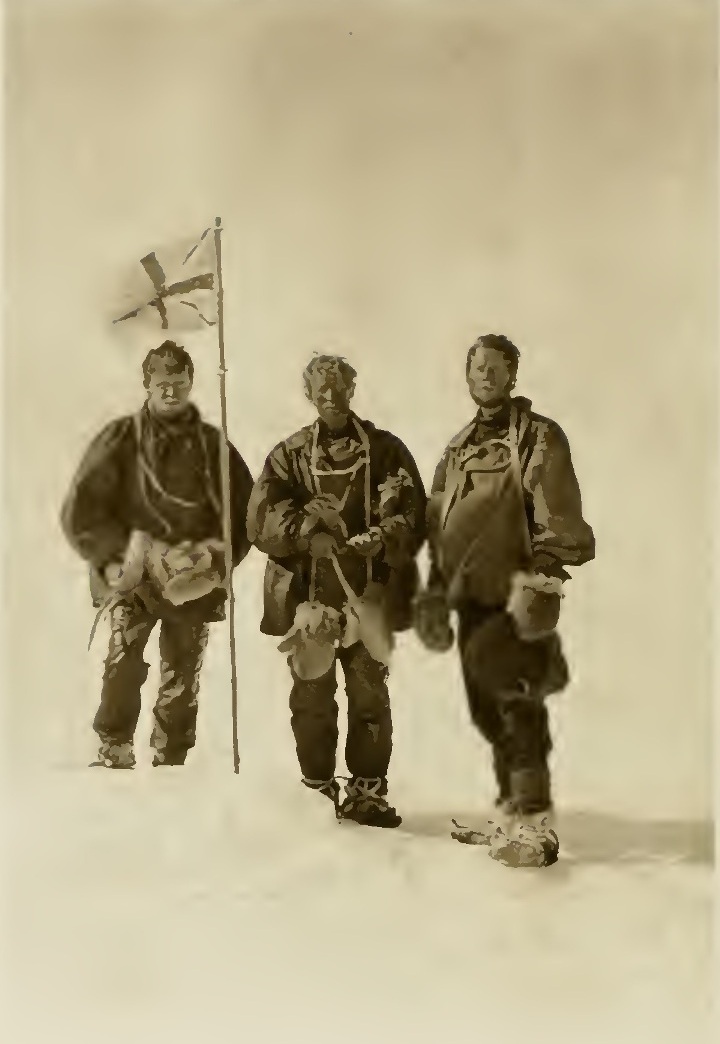
1. The Northern Party at the South Magnetic
Pole Frontispiece
From left: Dr. Mackay, Professor David, Douglas Mawson
In pocket of binding-case [at the
end.]
73
ON September 19, 1908, Lieutenant Shackleton gave me his final instructions for the journey of the Northern Party to the Magnetic Pole. These he read over to me in the presence of Mawson and Dr. Mackay. The instructions were as follows:
"British Antarctic
Expedition, 1907.
"Cape Royds, September 19,
1908.
"Dear Sir,—The sledge-party which you have charge of consists of yourself, Douglas Mawson and Alistair Mackay.
"You will leave winter quarters on or about October 1, 1908. The main objects of your journey are to be as follows:
"(1) To take magnetic observations at every suitable point with a view of determining the dip and the position of the Magnetic Pole. If time permits, and your equipment and supplies are sufficient, you will try and reach the Magnetic Pole.
"(2) To make a general geological survey of the coast of Victoria Land. In connection with this work you will not sacrifice the time that might be used to carry out the work noted in paragraph (1). It is unnecessary for me to describe or instruct you as to details re this work, as you know so much better than I do what is requisite.
"(3) I particularly wish you to be able to work at the geology of the Western Mountains, and for Mawson to spend at least one fortnight at Dry Valley to prospect for minerals of economic value on your return from the north, and for this work to be carried out satisfactorily you should return to Dry Valley not later than the first week of January. I do not wish to limit you to an exact date for return to Dry Valley if you think that by lengthening your stay up north you can reach the Magnetic Pole, but you must not delay, if time is short, on your way south again to do geological work. I consider that the thorough investigation of Dry Valley is of supreme importance.
"(4) The Nimrod is expected in the Sound about January 15, 1909. It is quite possible you may see her from the west. If so, you should try to attract attention by heliograph to winter quarters. You should choose the hours noon to 1 p.m. to flash your signal, and if seen at winter quarters the return signal will be flashed to you, and the Nimrod will steam across as far as possible to meet you and wait at the ice-edge. If the ship is not in, and if she is and your signals are not seen, you will take into account your supply of provisions and proceed either to Glacier Tongue or Hut Point to replenish if there is not a sufficient amount of provision at Butter Point for you.
"(5) Re Butter Point. I will have a depôt of at least fourteen days' food and oil cached there for you. If there is not enough in that supply you ought to return as mentioned in paragraph (4).
"(6) I shall leave instructions for the master of the Nimrod to proceed to the most accessible point at the west coast and there ship all your specimens. But before doing this, he must ship all the stores that are lying at winter quarters, and also keep in touch with the fast ice to the south on the lookout for the Southern Sledge-party. The Southern Party will not be expected before February 1, so if the ship arrives in good time you may have all your work done before our arrival from the south.
"(7) If by February 1 after the arrival of the Nimrod, there is no evidence that your party has returned, the Nimrod all proceed north along the coast, keeping as close to the land as possible, on the lookout for a signal from you flashed by heliograph. The vessel will proceed very slowly. The ship will not go north of Cape Washington. This is a safeguard in event of any accident occurring to your party.
"(8) I have acquainted both Mawson and Mackay with the main facts of the proposed journey. In the event of any accident happening to you, Mawson is to be in charge of the party.
"(9) Trusting that you will have a successful journey and a safe return.
"I am yours faithfully,
"(Sgd.) Ernest H.
Shackleton,
"Commander."
"Cape
Royds,
"British Antarctic Expedition,
1907.
"Professor David.
"Dear Sir,—If you reach the Magnetic Pole, you will hoist the Union Jack on the spot, and take possession of it on behalf of the above expedition for the British nation.
"When you are in the Western Mountains, please do the same at one place, taking possession of Victoria Land as part of the British Empire.
"If economic minerals are found, take possession of the area in the same way on my behalf as Commander of this expedition.
"Yours faithfully,
"(Sgd.) Ernest H.
Shackleton,
"Commander."
We had a farewell dinner that night, given in honour of the Southern Depôt Party who were about to start to lay out a depôt one hundred miles southerly from our winter quarters.
The following day, September 20, a strong south-easterly blizzard was blowing. In the afternoon the wind somewhat moderated, and there was less drift. Mackay had been making a sail for our journey to the Magnetic Pole, and we now tried the sail on two sledges lashed together on the ice at Backdoor Bay. We used the tent poles of one of the sledging-tents as a mast. The wind was blowing very strongly and carried off the two sledges with a weight on them of 300 lb., in addition to the weights of Mackay and myself, who were sitting on the sledges. We considered this a successful experiment.
The weather continued bad till the night of the 24th.
On September 25 we were up at 5.30 a.m., and found that the blizzard had subsided. Priestley, Day and I started in the motor-car, dragging behind us two sledges over the sea ice. One sledge, weighing altogether 606 lb. with its load, contained five of our fortnightly food-bags, six large tins of biscuits, and 60 lb. of oil. The other sledge, which with its load weighed about 250 lb., carried personal gear which we might have to use on the depôt laying trip in the event of being surprised by a blizzard. At first Day travelled on his first gear; he then found that the engine became heated, and we had to stop for it to cool down. He discovered while we were waiting that one of the cylinders was not firing. This he soon fixed up all right. He then remounted the car and he put her on to the second gear. With the increased power given by the repaired cylinder we now sped over the floe-ice at fourteen miles an hour, much to the admiration of the seals and penguins. When, however, we had travelled about ten miles from winter quarters, and were some five miles westerly from Tent Island, we encountered numerous sastrugi of softish snow, the car continually sticking fast in the ridges. A little low drift was flying over the ice surface, brought up by a gentle blizzard. We left the heavy sledge ten miles out, and then with only the light sledge to draw behind us, Day found that he was able to travel on his third gear at eighteen miles an hour. At this speed the sledge, whenever it took one of the snow sastrugi at right angles, leapt into the air like a flying fish and came down with a bump on the surface of the ice. As we had occasionally to make sharp turns in order to avoid sastrugi and lumps of ice, our sledge had one or two capsizes. Meanwhile, the blizzard was freshening, and we tore along in hopes of reaching our winter quarters before it became very violent. We had just reached Flagstaff Point, and were taking a turn in towards the shore opposite the penguin rookery when the blizzard wind caught the side of the sledge nearly broadside on, and capsized it heavily. So violent was the shock that the aluminium cooking apparatus was knocked out of its straps, and the blizzard wind immediately started trundling this metal cylinder over the smooth ice. Day stopped his car as soon as possible, Priestley and I jumped off, and immediately gave chase to the runaway cooker. Meanwhile, the cooker had fallen to pieces so to speak; the tray part came away from the big circular cover; the melter and the supports for the cooking-pot and for the main outer covering also came adrift as well as the cooking-pot itself. The lid of the last-mentioned fell off, and immediately dumped on to the ice the three pannikins and our three spoons. These articles raced one another over the smooth ice-surface in the direction of the open water of Ross Sea. The spoons were easily captured, as also were the pannikins, which, being conical in shape, could not be bowled by the wind in a straight line, but described arcs of circles. Priestley and I recovered also the cooking-pot, and with Brocklehurst's help (for he had run down to meet us) the aluminium supports, but the large snow melter, the main outer casing, and the tray kept revolving in front of us at a speed which was just sufficient to outclass our own most desperate efforts. Finally, when we were nearly upon them, they took a joyous leap over the low cliff of floe-ice and disappeared one after another most exasperatingly in the black waters of the Ross Sea.
This was a shrewd loss, as aluminium cookers were, of course, very scarce. Priestley and I returned disconsolate, and very much winded after our mile's run in vain.
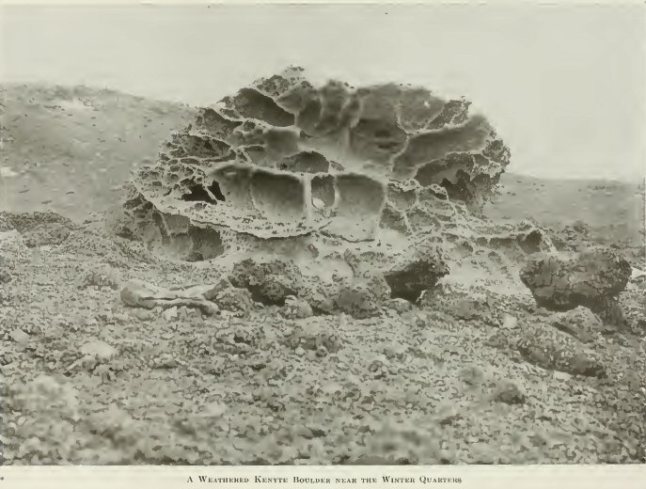
The following day we had intended laying out our second depôt, but as some of the piston rings of the motor-car needed repair, we decided to postpone the departure until the day after. That afternoon, after the repairs had been completed, Day and Armytage went out for a little tobogganing before dinner. Late in the evening Armytage returned dragging slowly and painfully a sledge bearing the recumbent, though not inanimate form of Day. We crowded round to inquire what was the matter, and found that just when Armytage and Day were urging their wild career down a steep snow slope Day's foot had struck an unyielding block of kenyte lava, and the consequence had been very awkward for the foot. It was severely staved, so that he was quite unable to walk without assistance. As no one but Day could be trusted to drive the motor-car, this accident necessitated a further postponement of the laying of our second depôt.
On September 28 it was blowing. On the 29th the day was fairly fine, but Day's foot was not well enough for him to start in the motor-car.
On September 30 a mild blizzard commenced blowing, and on October 1, the day on which Lieutenant Shackleton had intended that we should start, it was still raging with increased force. That day was spent chiefly in nailing strips of tin, painted blue, on all the geological specimen boxes, and double-labelling them.
On October 2 the weather was still bad, so that we were unable to start. On October 3, the weather having cleared. Day, Priestley, Mackay and I started with two sledges to lay our second depôt. All went well for about eight miles out, then the carburetter played up. Possibly there was some dirt in the nozzle. Day took it all to pieces in the cold wind, and spent three-quarters of an hour in fixing it up. We then started off again gaily in good style. We crossed a large crack in the sea ice where there were numbers of seals and Emperor penguins. On the other side of this crack our wheels stuck fast in snow sastrugi. All hands got on to the spokes and started swinging the car backwards and forwards; when we got a good swing on, Day would suddenly snatch on the power and over we would go—that is, over one of the sastrugi—only to find, often, that we had just floundered into another one ahead. In performing one of these evolutions Priestley, who as usual, was working like a Trojan, got his hand rather badly damaged through its being jammed between the spokes of the car wheel and the framework. Almost immediately afterwards one of my fingers was nearly broken, through the same cause, the flesh being torn off one of my knuckles; and then Mackay seriously damaged his wrist in manipulating what Joyce called the "thumb-breaking" starter. Still we went floundering along over the sastrugi and ice cracks, Day every now and then getting out to lighten the car and limping alongside. At last we succeeded in reaching a spot amongst the snow sastrugi on the sea ice, fifteen miles distant from our winter quarters. Here we dumped the load intended for the Northern Party, and then Day had a hard struggle to extricate the car from the tangle of sastrugi and ice-cracks. At last, after two capsizes of the sledges, we got back into camp at 10 p.m., all thoroughly exhausted, all wounded and bandaged. Brocklehurst carried Day on his back for about a quarter of a mile from where we left the car up to our winter quarters. So thoroughly exhausted were we, that we had to take a day's rest on October 4, before making our final start.
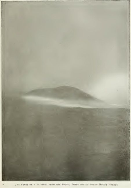
34. The Start of a
Blizzard from the South; Drift
coming round Mount Erebus
The following are the details respectively of our permanent load and equipment and of our consumable load (food and oil) when we did eventually start:
| Weight. | ||||
| Lb. | Oz. | |||
| 2 11-ft. sledges | . . . | 120 | 0 | |
| Tent, poles and floorcloth | . . . | 30 | 0 | |
| Shovel | . . . | 6 | 0 | |
| Primus and cooker | . . . | 20 | 0 | |
| Three-man sleeping bag | . . . | 26 | 0 | |
| 3 dozen plates | . . . | 3 | 0 | |
| ¼-plate camera and case | . . . | 4 | 13 | |
| Legs of camera | . . . | 1 | 14 | |
| Lloyd Creak dip circle | . . . | 23 | 0 | |
| Legs for dip circle | . . . | 7 | 0 | |
| Spirit for Primus stove | . . . | 9 | 0 | |
| 1 ready bottle for spirit | . . . | 0 | 8 | |
| Sail and yard | . . . | 11 | 0 | |
| Venesta board for table Centimetre rule Horn protractor Pencils "Hints to Travellers" and Nautical Almanac |
} } } } } } |
. . . | 1 | 10 |
| 3-inch, theodolite and case | . . . | 9 | 0 | |
| Legs of theodolite | . . . | 5 | 4 | |
| Field-glasses | . . . | 1 | 13 | |
| 3 ice axes, 3 lb. each | . . . | 9 | 0 | |
| Rucksack and 60 ft. Alpine rope | . . . | 6 | 0 | |
| Haversack, hammer and chisel | . . . | 3 | 0 | |
| Aneroid 2 prismatic compasses |
] ] |
. . . | 3 | 0 |
| 2 pairs of sledge thermometers in cases 2 low-temperature thermometers |
} } |
. . . | 0 | 12 |
| 1 hypsometer in case | . . . | 1 | 0 | |
| Labels and small bags for specimens | . . . | 1 | 0 | |
| Repair kit | . . . | 2 | 0 | |
| Copper wire | . . . | 0 | 4 | |
| Cod-line | . . . | 1 | 0 | |
| Leather for repairs | . . . | 2 | 0 | |
| 1 pair shooting-boots for depot at Butter Point | . . . | 3 | 8 | |
| 1 pair ski-boots (Mawson) | . . . | 2 | 8 | |
| 1 pair ski-boots (David) | . . . | 2 | 8 | |
| 3 pairs ski-boots | . . . | 12 | 0 | |
| 9 pairs finnesko, 2¼ lb. each | . . . | 20 | 4 | |
| Charts and tin case | . . . | 1 | 0 | |
| Dram case of paper | . . . | 1 | 0 | |
| 30 lb. of personal gear 6 lb. of bags |
} } |
. . . | 36 | 0 |
| Prickers, nipples, and washers for Primus | . . . | 0 | 8 | |
| 3 hanks sennegrass | . . . | 4 | 8 | |
| 3 bags for drying sennegrass | . . . | 0 | 8 | |
| Medical bag | . . . | 5 | 0 | |
| Depot flags, jack, and poles | . . . | 4 | 0 | |
| Sledge harness | ||||
| Sledge ropes and toggles | ||||
| Small set of tools | ||||
| Books: Field notebooks. "Magnetic Memoir of Discovery Expedition." Sketch-book. |
||||
| Lb. | Oz. | ||
| Plasmon biscuit: 1 lb. per man per day = 3 lb. per day. 93 days × 3 = 279 lb. Substitute for oatmeal, 1 lb. 3 oz. for 3 men per week × 13 = 14 lb. 10 oz. |
= | 294 | 0 |
| Pemmican: 7.5 oz. per man per day × 3 × 93 = 2092 oz. | = | 131 | 0 |
| Emergency rations (checked by Marshall): l½ oz. per man per day × 3 × 93 = 418½ oz. |
= | 26 | 0 |
| Sugar (lumps): 3.8 oz. per man per day × 3 × 93 | = | 70 | 0 |
| Tea (twice a day): a little less than half a tin per week | = | 9 | 0 |
| Rowntree's Sweet Chocolate: 8 oz. per man per week = normal allowance. 4½ " do. = substitute for honey. 12½ oz. do. 12½ × 3 × 13 = 487 oz. |
= | 32 | 0 |
| Cocoa: 14½ oz. for three men per week (once a day for dinner). 14½ × 13 = 188 oz. Out of this plasmon cocoa available for 6 weeks. |
= | 12 | 0 |
| Cheese: 2 oz. per man per day, 3 days per week = 18 oz. per week. 18 oz. × 13 = 239 oz. |
= | 15 | 0 |
| Plasmon and dried milk | = | 17 | 7 |
| Salt: 2 oz. per week for 2 men = 4 oz. per week × 13 = 52 oz. |
= | 3 | 4 |
| Paraffin oil in 10-lb. tins | = | 100 | 0 |
| —— | —— | ||
| 709 | lb. |
October 4 was a Sunday, and after the morning service we took the ponies out for exercise. In the evening the gramophone discoursed appropriate music, such as "We parted on the Shore", "I and my true love will never meet again by the bonnie, bonnie banks of Loch Lomond", concluding with the universal favourite, "Lead, Kindly Light".
Meanwhile, Mackay had his damaged wrist attended to, and I put the question to him as to whether or not he was prepared to undertake the long journey to the Magnetic Pole under the circumstances. He said that he was quite ready, provided Mawson and I did not object to his going with his wrist damaged and in a sling. We raised no objection, and so the matter was settled. All that night Mawson and I were occupied in writing final letters, and packing little odds and ends.
The following morning, October 5, after an early breakfast, we prepared for the final start. It was quite wonderful what a lot of things had been forgotten until this last moment. The sledges were dragged down, from our hut to the edge of the sea ice at the Penguin Rookery, a distance of a little over a quarter of a mile. Day was there with the motor-car, ready for the start. Every now and then some one of the pilgrims would remember that he had left something very important behind at the hut, and would go running back for it. These odd belongings had to be tied with bits of string on to the second sledge which we were going to take with us on our northern journey, consequently, by degrees, this sledge became hung over with boots, crampons, and all sorts of what Day called "gadgets". Murray, Brocklehurst and Armytage came down on the ice to bid us a final farewell. Brocklehurst took a photograph of us just before we started, then Day, Priestley, Roberts, Mackay, Mawson and I got aboard, some on the motor-car, some on the sledges. Those remaining behind gave us three cheers, Day turned on the power and away we went. A light wind was blowing from the south-east at the time of our start, bringing a little snow with it and another blizzard seemed impending.
After travelling a little over two miles, just beyond Cape Barne, the snow had become so thick that the coastline was almost entirely hidden from our view. Under these circumstances I did not think it prudent to take the motor-car further, so Mackay, Mawson and I bid adieu to our good friends. Strapping on our harness we toggled on to the sledge rope, and with a one, two, three, and away, pulled off into the thick falling snow, which in a few minutes blotted out all view of the motor-car in our rear. As we slowly trudged along the signs of an approaching blizzard became more pronounced and we bore somewhat to our left so as to have Inaccessible Island as a lee under which to run for shelter, but after a time, as the threatened blizzard did not come up, we slewed our sledge more to the right, away from Inaccessible Island, heading up for our ten-mile depôt. At last, towards evening Mackay sighted the black flag over the depôt about a mile distant.
We reached the depôt about 7 p.m. and got up our tent. A fairly strong wind was still blowing from the south-east, raising low drift. We slept that night on the floe-ice, with about three hundred fathoms of water under our pillow.
The following morning, October 6, we started our relay work. We dragged the Christmas Tree sledge on first, as we were specially liable to lose parcels off it, for a distance of from one-third to half a mile. Then we returned and fetched up what we called the Plum Duff sledge, chiefly laden with our provisions. The light was dull, and a certain amount of soft, newly-fallen snow made the sledging heavy. The weather may be described as thick, with snow falling at intervals. During the afternoon it cleared somewhat and the Western Mountains came into view at about 2 p.m. This was fortunate for us, as it enabled us later on to sight the flag over our fifteen-mile depôt. We camped that night amongst screw pack-ice within less than a mile of this depôt.
The following day, October 7, was beautifully fine and calm. We started about 9 a.m. and sledged over pressure ice ridges and snow sastrugi, reaching our fifteen-mile depôt in three-quarters of an hour. Here we camped and repacked our sledges. We took the wholemeal plasmon biscuits out of two of the biscuit tins and packed them into canvas bags. This saved us a weight of about 8 lb.
We started again in the afternoon, relaying with the two sledges. The sledging again was heavy on account of the fresh, soft snow, and small sastrugi. We had a glorious view of the Western Mountains, crimsoned in the light of the setting sun. We camped that night close to a seal hole which belonged to a fine specimen of Weddell seal. We were somewhat disturbed that night by the snorting and whistling of the seals as they came up for their blows. Evidently this seal hole was a syndicate affair. The sounds at times seemed right under our tent.
October 8 was a fine, clear day, with a beautiful sunset, and a magnificent mirage, in the direction of Beaufort Island. To the north of us, the curious hills, called by Captain Scott the "Stranded Moraines", were now beginning to show out very plainly in the direction in which we were travelling.
On the morning of October 9 we got under way soon after eight o'clock. It was a lovely, calm day but cold, the thermometer registering 30 Fahr. at 8 p.m. The surface was fairly good for sledging, but in places we came on patches of soft snow, and a small, lumpy structure of the ice-surface, resembling a newly raked garden bed, evidently due to the thawing down and refreezing of "ice flowers". This made travelling very heavy. The "Stranded Moraines" now showed up very clearly, and Butter Point itself became visible.
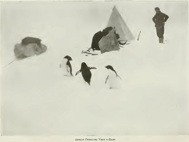
The following day, Saturday, October 10, we were awakened by the chatter of some Emperor penguins who had marched down on our tent during the night to investigate us. The sounds may be described as something between the cackle of a goose and the chortle of a kookaburra. On peeping out of the Burberry spout of our tent I saw four standing by the sledges. They were much interested at the sight of me, and the conversation between them became lively. They evidently took us for penguins of an inferior type, and the tent for our nest. They watched, and took careful note of all our doings, and gave us a good send-off when we started about 8.30 a.m.
On our journey that morning we passed close by a large bull seal of the Weddell species. A little further on we noticed a curious dark object on the ice in the distance, and on coming up to it found that it was a dead Weddell seal with its head, neck, and shoulders firmly frozen into the ice. Evidently it had stuck fast in a seal hole in the ice in trying to get down to the sea-water.
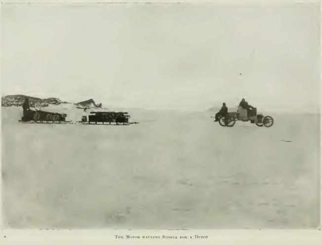
37. The Motor hauling Stores for a Depot
The sky was overcast, and light snow began to fall in the afternoon. A little later a mild blizzard sprang up from the south-east; we thought this a favourable opportunity for testing the sailing qualities of our sledges, and so made sail on the Plum Duff sledge. As Mackay put it, we "brought her to try with main course". As the strength of the blizzard increased, we found that we could draw both sledges simultaneously, which was, of course, a great saving in labour. We were tempted to carry on in the increasing strength of the blizzard rather longer than was wise, and consequently, when at last we decided that we must camp, had great difficulty in getting the tent up. We slipped the tent over the poles placed close to the ground in the lee of a sledge. While two of us raised the poles, the third shovelled snow on to the skirt of the tent, which we pulled out little by little, until it was finally spread to its full dimensions. We were glad to turn in and escape from the biting blast and drifting snow.
The following day, Sunday, October 11, a violent blizzard was still blowing, and we lay in our sleeping-bag until past noon, by which time the snow had drifted high upon the door side of our tent. As this drift was pressing heavily on our feet and cramping us, I got up and dug it away. The cooker and Primus were then brought in and we all got up and had some hoosh and tea. The temperature, as usually happens in a blizzard, had now risen considerably, being 8.5° Fahr. at 1.30 p.m. The copper wire on our sledges was polished and burnished by the prolonged blast against it of tiny ice crystals, and the surface of the sea ice was also brightly polished in places. As it was still blowing we remained in our sleeping-bag for the rest of that day as well as the succeeding night.
When we rose at about 2 a.m. on Monday, October 12, the blizzard was over. We found very heavy snowdrifts on the lee side of our sledges, and it took us a considerable time to dig these away and get the hard snow raked out of all the chinks and crannies among the packages on the sledges. We made a start about 4 a.m., and all that day meandered amongst broken pack-ice. It was evident that the south-east blizzards drive large belts of broken floe-ice in this direction across McMurdo Sound to the western shore. The fractured masses of sea ice, inclined at all angles to the horizontal, are frozen in later, as the cold of winter becomes more intense, and of course, constitute a very difficult surface for sledging.
In order to make up for the time we had lost in our sleeping-bags during the blizzard, we travelled altogether fourteen hours, and succeeded in doing about six statute miles, that is, eighteen miles of relay work, and all felt much exhausted when we turned in that evening. As a result of this we did not wake until after 8 a.m next morning.
We were now only about two miles from Butter Point. We got under way at 10 a.m., and a few hours later camped at the foot of a low ice cliff, about 600 yards south-south-east of Butter Point. Butter Point is merely an angle in this low ice cliff near the junction of the Ferrar Glacier valley with the main shore of Victoria Land. This cliff was from fifteen to twenty feet in height, and formed of crevassed glacier ice. It was covered by a hard snow crust, which every now and then gave away and let one down for a foot or so. This glacier ice was not part of the main Ferrar Glacier, but appeared to be simply a local piedmont glacier stretching along for some considerable distance between the base of the coast range and the sea ice, past the "Stranded Moraines", until still further south it became confluent with that Mr. H. G. Ferrar has described as the "pinnacled ice". It was evident that this piedmont ice was firmly attached to the land, as it was separated from the sea ice, by a well-marked tide-crack. With the help of our ice axes we crossed over this crack and got up the little ice cliff on to the glacier ice, and selected there a suitable spot for our depôt.
According to arrangements with Lieutenant Shackleton we were to leave a depôt flag at Butter Point with a letter giving an account of our doings, and stating approximately by what date we hoped to return there. But the progress of our journey had been so much slower than we had originally anticipated that we decided before reaching Butter Point that it would be imperatively necessary, in order to make the Magnetic Pole in the time available, to lighten the load on our sledges by leaving a portion of our equipment and food.
During the latter part of this day Mawson and Mackay were busy making a mast and boom for the second sledge, it being our intention to use the tent floorcloth as a sail. Meanwhile I sorted out the material to be left at the depôt.
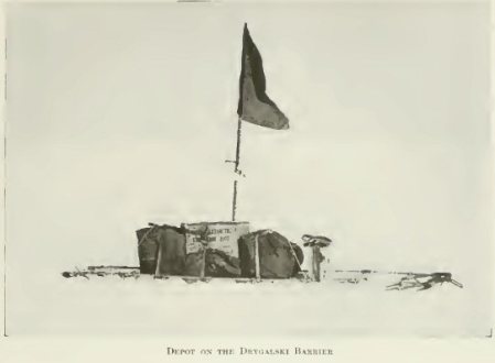
The following day, Wednesday, October 14, we spent the morning in resorting the loads on our sledges. We depôted two tins of wholemeal plasmon biscuits, each weighing about 27 lb., also Mackay's mountaineering nail boots, and my spare headgear material and mits. Altogether we lightened the load by about 70 lb. We sunk the two full tins of biscuits and a tin containing boots, &c., a short distance in the glacier ice to prevent the blizzards blowing them away. We then lashed to the tins a short bamboo flagpole, carrying one of our black depôt flags, and securely fastened to its base one of our empty airtight milk tins, in which we])laced our letters. In these letters for Lieutenant Shackleton and R. E. Priestley, respectively, I stated that in consequence of our late start from Cape Royds, and also on account of the comparative slowness of our progress thence to Butter Point, it was obvious that we could not return to Butter Point until January 12, at the earliest, instead of the first week of January, as was originally anticipated. We ascertained months later that this little depôt survived the blizzards, and that Armytage, Priestley and Brocklehurst had no difficulty in finding it, and that they read our letters.
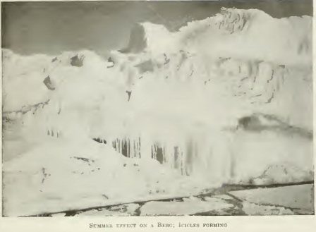
Leaving the depôt about 9 a.m. on October 14, we started sledging across New Harbour in the direction of Cape Bernacchi. In the afternoon a light southerly wind sprang up bringing a little snow with it, the fall lasting from about 12.30 to 2.30 p.m. We steered in the direction of what appeared to us to be an uncharted island. On arriving at it, however, we discovered that it was a time iceberg, formed of hard blue glacier ice with a conspicuous black band near its summit formed of fine dark gravel. The iceberg was about a quarter of a mile in length, and thirty to forty feet high. In addition to the coarser bands of gravel there was a great quantity of dust, and fine dust bands, near the surface of the berg. This dust absorbing the heat of the sun had thawed its way deep down into the berg, thus forming numerous dust wells and dust grooves. There were several large cracks in the sea ice in the neighbourhood of this iceberg, and having taken the bearing of the trend of these by a compass they helped us to keep direction when the air was thick 'with falling snow.
The following day, October 15, was beautifully fine and calm; the sky was slightly cloudy with long belts of cirrus-stratus and alto-stratus. Erebus, now over fifty miles distant, was cloud capped. We had a glorious view up the magnificent valley of the Ferrar Glacier; the spurless hills on either side of the valley, strongly faceted in a direction parallel to each side of the valley, spoke eloquently of intense abrasive glacial action in the immediate geological past. The hills in the foreground, formed of gneissic granite, were of a rich chocolate brown to warm sepia hue, fading in the distance to exquisite tints of reddish purple and violet. Towards evening we had a wonderful vision of several large icebergs close ahead of us; it seemed as though they were only a mile or so distant, as one could see clearly the re-entering angles and bright reflected sides of the bergs lit up in the rays of the setting sun. Suddenly, as if by magic, they all vanished. They had been momentarily conjured up to our view by a wonderful mirage. In the departing rays of the setting sun Mount Erebus and Mount Bird glowed with a glorious golden light. This was one of the most beautiful days we experienced during the whole of our journey. The cold was now less severe than it had been, the temperature being 9.5° Fahr. at 8 p.m.
92
ON October 16 we were up at 3.30 a.m., and got under way at 5.30. A cold wind was blowing from the south, and after some trouble we set sail on both sledges, using the green floorcloth on the Christmas Tree sledge, and Mackay's sail on the Plum Duff sledge. A short time after we set sail it fell nearly calm; thick clouds gathered; a light wind sprang up from the south-east, veering to east-north-cast, then back again to south-east in the afternoon. Fine snow fell for about three hours, forming a layer nearly a quarter of an inch in thickness. Towards evening we reached one of the bergs that had been miraged up the night before. It was four hundred yards long, and eighty yards wide, and was a true iceberg formed of glacier ice; Mackay, Mawson and I explored this. Like the previous iceberg its surface was pitted with numerous deep dust wells. It was wonderful to see what a very small amount of dust sufficed to dig these wells to a depth of several feet. The cliff of the berg which faced towards the north-west was deeply grooved, the appearance in the distance reminding one of a number of large parallel stalactites. Climbing up one of these deep grooves I found numbers of small angular rock pebbles, up to one and a half inches in diameter, adhering to the bottom of the groove, and it seemed as though these grooves, like the dust wells, were formed by the warmth of these small fragments of rock which, as the process of thawing of the ice cliff progressed, gradually settled down into long rows or strings as they crept gradually downwards under the influence of gravitation to the level of the sea ice below. As the shore was high and rocky, and seemed not more than half a mile distant, I went over towards it after our evening meal. It proved to be somewhat further than it appeared.
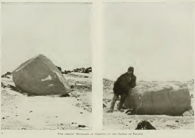
On the way, for the first time, I met with a structure in the sea ice known as pancake ice. The surface of the ice showed a rounded polygonal structure something like the tops of a number of large weathered basaltic columns. The edges of these polygons were slightly raised, but sufficiently rounded off by thawing or ablation to afford an easy surface for the runners of our sledge. Later on, in the autumn of the following year, we noticed this pancake ice in process of formation. If, as was often the case, there was any wind when the sea began to freeze over, the water at first commenced to look soupy; little by little the small ice particles which caused this appearance aggregated and formed myriads of small structures which may be likened to small open jam tarts. These would then coalesce in groups at their edges and form pancake ice. These pancakes were from one foot up to about three feet in diameter. Later, the pancakes would cohere and so a continuous hard ice crust would be formed over the sea surface; later freezing simply had the effect of strengthening and thickening this ice-sheet from below. Close in shore the pancake ice was traversed by deep tidal cracks. After climbing over these I reached the shore, which was composed of a well-marked terrace of coarse gravel and large and small erratic boulders. The smaller rock fragments were from three to six inches in diameter, the boulders being as much as five feet in diameter. The lower terrace was about twenty yards wide and as many feet in height above the sea; then followed a belt of coarsely crystalline white marble traversed by bands of grey gneiss and blackish rock. Capping this belt of ancient crystalline rocks was a terrace of angular gravel, from eighty to one hundred feet above sea-level, formed of small rock fragments from one to two inches in diameter. The belts of coarse marble, gneiss, &c., were stained green and reddish to ochreous brown in places, and appeared to have been much mineralised. The whole area seemed to promise well for economic minerals. One curious boulder specially attracted my attention; its large pinkish crystals were peppered over with small black crystals, the whole being enclosed in a greenish black base. A specimen of this boulder which we brought back with us will be described in detail in the geological notes.
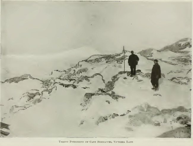
On Saturday, October 17, Mawson, Mackay and I landed at Cape Bernacchi, a little over a mile north of our previous camp. Here we hoisted the Union Jack just before 10 a.m. and took possession of Victoria Land for the British Empire. Cape Bernacchi is a low rocky promontory, the geology of which is extremely interesting. The dominant type of rock is a pure white coarsely crystalline marble; this has been broken through by granite rocks, the latter in places containing small red garnets. The marble or talc schist contains graphite disseminated through it in small scales. A great deal of tourmaline and epidote are developed in the granite at its point of contact with the calcareous schists. It appeared that the granite had intruded the black tourmaline rocks.
38. Morainic Cone with
Raised Beach Material.
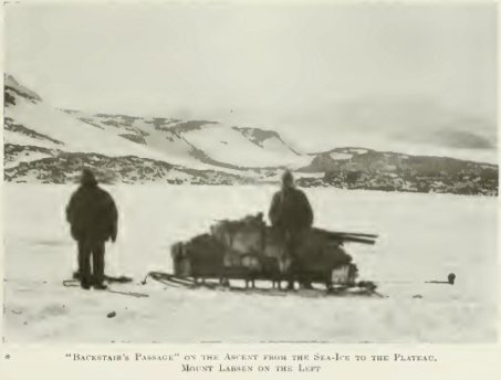
Mount Larsen on the Right. "Backstairs Passage"
is behind the Cone
39. One of the Sledges taken by the Northern Party
40. Taking Possession of Cape Bernacchi, Victoria Land
After taking possession we resumed our sledging, finding the surface of pancake ice very good. The day being calm and clear and free from either falling or drifting snow, we were able, for the first time, to turn our sleeping-bag inside out and air it in the sun. Previous to this the reindeer fur inside the bag had become much encrusted with ice, chiefly the result of the freezing of our breath. Although the heat of the sun was insufficient to actually thaw the ice it evaporated it to a considerable extent, and we found the bag that night much more comfortable to sleep in than it had been for many nights previous.
The following day, one and a quarter miles north of our preceding camp, we reached an interesting rocky headland. Here we found a mother seal with a newly born baby seal, the latter about three and a half feet in length. The mother seal at short intervals made a sound like "Wa-a-a". After a close inspection the mother and baby were left undisturbed, and we turned our attention to the rocks. These were most interesting, bearing a general resemblance to those at Cape Bernacchi. Some of the quartz veins traversing this point Mawson thought very favourable for gold.
When we left this point the wind had considerably freshened. We had previously hoisted sail on both sledges, and the wind was now sufficiently strong to admit of our pulling both sledges together. The total distance travelled was seven statute miles. This was the most favourable wind we experienced during the whole of our journey to and from the Magnetic Pole.
Shortly after leaving Baby Seal Point we encountered heavy belts of screw pack-ice with high sastrugi between. The Christmas Tree sledge capsized badly when being dragged over one of these high snow ridges. We were much exhausted when we camped that night and had suffered somewhat from the cold wind, the temperature being about 10° Fahr.
That night I experienced a rather bad attack of snow-blindness, through neglecting to wear my snow goggles regularly. Finding that my eyes were no better next morning, and my sight being dim, I asked Mawson to take my place at the end of the long rope, the foremost position in the team. Mawson proved himself on this occasion and afterwards so remarkably efficient at picking out the best track for our sledges, and steering a good course that by my request he occupied this position throughout the rest of the journey.
The next two days were uneventful, except for the fact that we occasionally had extremely heavy sledging over screw pack-ice and high and long sastrugi. The latter were from two to three feet high, bounded frequently by almost perpendicular sides, and as they trended from west to east and our course was from south to north they proved formidable obstacles to our progress, and capsizes of the sledges were frequent.
On the night of October 20, we camped on the sea ice about three-quarters of a mile off shore. To the north-east of us was an outward curve of the shoreline, shown as a promontory on the existing chart. Early the next morning I walked over to the shore to geologise, and found the rocky headland composed of curious gneissic granite veined with quartz. On ascending this headland I noticed to my surprise that what had been previously supposed to be a promontory was really an island separated by a narrow strait from the mainland. It was clear that by going through this strait we would save several miles. Accordingly, after breakfast we sledged into the strait. The western side of the strait was formed of glacier ice terminating eastward in an almost precipitous slope. Here and there masses of gneissic granite showed from beneath the ice. The eastern side of the strait was formed of terraced moraine gravels with large erratics embedded in the gravel of the top terrace, eighty feet above sea-level.
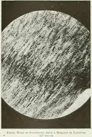
While Mawson determined the position of this island by taking a round of angles with the theodolite, Mackay and I crossed the strait and explored the island, pacing and taking levels. The rocks of which the erratics and boulder-bearing gravels were formed were almost without exception of igneous origin. One very interesting exception was a block of weathered clayey limestone. This was soft and yellowish grey externally but hard and blue on the freshly fractured surfaces inside. It contained traces of small fossils which appeared to be seeds of plants. Specimens of these were taken by us and were depôted later at another small island, which we called Depôt Island. It is much to be regretted that we were unable later to reach this depôt on account of dense belts of pack-ice, and so these very interesting specimens were lost. Two chips, however, of this rock were fortunately preserved, sufficient for chemical analysis and microscopic examination. There could be little doubt that this clayey limestone has been derived from the great sedimentary formation, named by H. T. Ferrar, the Beacon Sandstone.
The island which we had been exploring we named provisionally Terrace Island. It was approximately triangular in shape, and the side facing the strait, down which we travelled, measured one mile 1200 yards in length.
The following day, October 22, we sighted the first skua gull we had seen that season. Snow fell in the afternoon between 2.30 and 5 p.m., forming a layer three-quarters of an inch deep. The temperature rose to plus 6.5° Fahr. at 7 p.m., and a blizzard seemed impending.
The following day October 23, we held a serious council as to the future of our journey towards the Magnetic Pole, It was quite obvious that at our present rate of travelling, about four statute miles daily by the relay method, we could not get to the Pole and return to Butter Point early in January. I suggested that the most likely means of getting to the Pole and back in the time specified by Lieutenant Shackleton would be to travel on half rations, depôting the remainder of our provisions at an early opportunity. They both agreed, after some discussion, to try this expedient, and we decided to think the matter over for a few days and then make our depôt.
We found, as the result of the fall of snow on the preceding day, that the runners of our sledge clogged, making it difficult to start the sledge after each halt. The temperature at 5 p.m. was now as high as plus 5° Fahr. There were numerous seals, mostly mother seals with young ones, on the ice near the course of our sledge, as many as seventeen seals being sometimes visible simultaneously.
The previous day we had observed a mother seal with twin baby seals. Mackay took up one of these in his arms and stroked it while it was nuzzling round. It somewhat resembled a large lizard. The mother snorted at him indignantly, meanwhile, but made no attempt to attack him.
We encountered some large cracks in the sea ice. The sea water between the opposite walls had been only recently frozen over so that the ice was not more than a few inches in thickness. One of these was eighteen feet wide, and we found that the ice bent under our weight when we tested it primarily. Mackay called it "The Bridge of the Beresina." We rushed the sledges over at a good speed, and although the ice bent under their weight it fortunately held. At about 3 p.m. the weather grew very thick and it began to snow; a mild blizzard developing later, we hoisted sail on both sledges.
The next day, October 24, we found it very warm in the sleeping-bag, the sky being thickly overcast with dense stratus cloud. A strong water sky showed up to the east of us, while over the mountains to the west it was moderately clear. The presence of this water sky, indicating open sea, warned us that it was unsafe to stand out far from the land. We reached that evening a long rocky point of gneissic granite, which we called Gneiss Point. After our evening hoosh we walked across to the point and collected a number of interesting geological specimens, including blocks of kenyte lava.
The following day, October 25, proved a very heavy day for sledging, as we had to drag the sledges over new snow from three to four inches deep. In places it had a tough top crust which we would break through up to our ankles. We met also several obstacles in the way of wide cracks in the sea ice, from six to ten feet in width, and several miles in length. The sea water between the walls of the cracks had only recently been frozen over, so that the ice was only just thick enough to bear the sledges. The vicinity of these great ice-cracks were perfect baby farms for young seals. It was a pretty sight to see one of these baby seals playing with its mother, whom it kept gently flicking over the nose with its small flippers, the mother every now and then gently boxing the baby's ear with one of her large flippers. One of these mothers charged down on Mackay, who was making an inspection of her baby at too close quarters to suit her fancy. Another mother was moaning in great distress over her baby, which had just died. Evidently the mother seal's affection for her young is very strong.
In pursuing our north-westerly course we were now crossing a magnificent bay which trended westwards some five or six miles away from the course we were steering. On either side of this bay were majestic ranges of rocky mountains parted from one another at the head of the bay by an immense glacier with steep ice falls. On examining these mountains with a field-glass it was evident that in their lower portions they were formed of granites and gneiss, producing reddish brown soils. At the higher levels, further inland, there were distinct traces of rocks showing horizontal stratification. The highest rock of all was black in colour, and evidently very hard, apparently some three hundred feet in thickness. Below this was some softer stratified formation, approximately one thousand feet in thickness. We concluded that the hard top layer was composed of igneous rock, possibly a lava, while the horizontal stratified formation belonged in all probability to the Beacon Sandstone formation. Some fine nunataks of dark rock rose from the south-east side of the great glacier. On either side of this glacier were high terraces of rock reaching back for several miles from a modern valley edge to the foot of still higher ranges. It was obvious that these terraces marked the position of the floor of the old valley at a time when the glacier ice was several thousand feet higher than it is now, and some ten miles wider than at present. The glacier trended inland in a general south-westerly direction.
We longed to turn our sledges shorewards and explore these inland rocks, but this would have involved a delay of several days—probably a week at least—and we could not afford the time. Mawson took a series of horizontal and vertical angles with the theodolite to all the upper peaks in these ranges. We were much puzzled to determine on what part of the charted coast this wide bay and great glacier valley was situated. We speculated as to whether it was Granite Harbour, but decided that it could not be in view of the distance recorded by our sledge meter, for, according to this, we must still be some twenty miles south of Granite Harbour proper. We were to find out much later that the point opposite which we had now arrived was in reality Granite Harbour, and that its position was not shown correctly on the chart. Of course in pioneering work occasional mistakes such as these are inevitable.
The following day the sledge still proved very heavy on account of the soft snow—two to four inches deep—which was continually clogging the runners of our sledges. It was also difficult to steer a good course amongst the hummocky pack-ice on account of the day being dull and overcast. There was much low stratus cloud, and a light south-easterly wind.
The weather of October 27 was beautifully clear and sunshiny, and we had a glorious view of the great mountain ranges on either side of Granite Harbour. The rich colouring of warm sepia brown and terra cotta in these rocky hills was quite a relief to the eye. Wind springing up in the south-east we made sail on both sledges, and this helped us a good deal over the soft snow and occasional patches of sharp-edged brash ice. Occasionally the runners of our sledge would catch on one of these sharp fragments, and there would be a harsh rasping sound as a shaving was peeled off the runner. We feared that the wind would develop into a true blizzard, but it proved to be only what Joyce used to call a "carpet sweeper", driving along the newly fallen snow in white gossamer-like films over the sea ice.
Towards evening we fetched up against some high ice-pressure cracks with the ice ridged up six to eight feet high in huge tumbled blocks. We seemed to have got into a labyrinth of these pressure ridges from which there was no outlet. At last, after several capsizes of the sledges and some chopping through the ice ridges by Mackay, we got the sledges through, and camped on a level piece of ice. We were much helped in crossing the ridges by the long steep sastrugi of hardened snow. In places these ran like ramps up to the top of the pressure ridges, and were just wide enough and strong enough to bear our sledges. Mawson and I at this time were still wearing finnesko, while Mackay had taken to ski boots.
The following day, October 28, the sledging was again very heavy over sticky soft snow alternating with hard sastrugi and patches of consolidated brash ice. Shavings of wood were being constantly rasped off the runners of our sledges. Mackay lost one of his finnesko off the sledge, but walked back a couple of miles in the evening and recovered it. Our course had taken us past a number of snowbergs; these were mostly about forty feet in height and from a quarter to half a mile in length. They were rigidly embedded in the sea ice. Occasionally we met with a true iceberg of blue ice amongst the snowbergs.
After our evening hoosh, Mawson and I went over to the shore, rather more than half a mile distant, in order to study the rocks. These we found were composed of coarse red granite; the top of the granite was much smoothed by glacier ice, and strewn with large erratic blocks. In places the granite was intersected by black dykes of basic rocks. One could see that the glacier ice, about a quarter of a mile inland from this rocky shore, had only recently retreated and laid bare the glaciated rocky surface. We found a little moss here amongst the crevices in the granite rock.
October 29 was beautifully fine, though a keen and fresh wind, rather unpleasantly cold, was blowing from off the high mountain plateau to our west. It blew from a direction west by south and caused a little low drift in the loose snow on the surface of the sea ice. There was still a great deal of deep, soft snow alternating with hard sastrugi and small patches of consolidated brash ice, so that the sledging was very heavy.
We were all thoroughly done up at night after completing our four miles of relay work. That evening we discussed the important question of whether it would be possible to eke out our food-supplies with seal meat so as to avoid putting ourselves on half rations, and we all agreed that this should be done. We made up our minds that at the first convenient spot we would make a depôt of any articles of equipment, geological specimens, &c., in order to lighten our sledges, and would at the same time, if the spot was suitable, make some experiments with seal meat. The chief problem in connection with the latter was how to cook it without the aid of paraffin oil. We could not afford more paraffin for this purpose, as we estimated that even with the utmost care the supply for our Primus, which we used for brewing tea, cocoa and hoosh, would become exhausted before we could hope to reach the Magnetic Pole, unless some kind of substitute for paraffin could be found.
The following day, October 30, was full of interest for us, as well as hard work. In the early morning, between 2.30 a.m. and 6.30 a.m., a mild blizzard was blowing. We got under way a little later and camped at about 10.30 a.m. for lunch alongside a very interesting rocky point. Mawson got a good set of theodolite angles from the top of this point. The point was formed of coarse porphyritic grey gneiss, traversed by black dykes of rock, apparently tinguaite, and another variety containing an abundance of sparkling black crystals of hornblende, which may be termed provisionally a hornblende lamprophyre.
After lunch we passed close by a mother seal and her baby. The mother charged us and we had to skid along quick and lively past her with the sledges. That day was the first occasion that we tried the experiment of strengthening the brew of the tea by using the old tea-leaves of a previous meal mixed with the new ones. This was Mackay's idea, and Mawson and I at the time did not appreciate the experiment. Later on, however, we were very glad to adopt it.
The sledging that afternoon was about the heaviest we had experienced up to date. The weather was now daily becoming warmer and the saline snow on the sea ice became sticky in consequence. It gripped the runners of the sledges like glue, and we were only able with our greatest efforts to drag the sledges over this at a snail's pace. We were all thoroughly exhausted that evening when we camped at the base of a rocky promontory about 180 ft. high. This cliff was formed of coarse gneiss, with numerous dark streaks, and enclosures of huge masses of greenish-grey quartzite.
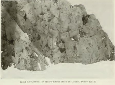
After our evening hoosh we walked over to a very interesting small island about three-quarters of a mile distant. It was truly a most wonderful place geologically, and was a perfect elysium for the mineralogist. The island, which we afterwards called Depôt Island, was accessible on the shoreward side, but rose perpendicularly to a height of 200 ft. above sea-level on the other three sides. There was very little snow or ice upon it, the surface being almost entirely formed of gneissic granite. This granite, as shown in the photograph, was full of dark enclosures of basic rocks, rich in black mica and huge crystals of hornblende. It was in these enclosures that Mawson discovered a translucent brown mineral, which he believed to be monazite, but which has since proved to be titanium mineral. Patches of a crystalline, milky-white mineral were to be seen amongst the large platy crystals of dark green hornblende. These white crystals we thought might be scapolite. We returned to camp and slept soundly after the severe work of the day.
41. Dark Enclosures of
Hornblende Rock in Gneiss,
Depot Island
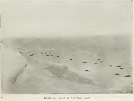
42. Seals on Coast of Victoria Land
We were up at 6 a.m. next morning, and after breakfast Mackay and Mawson went in pursuit of some seals which we had sighted further back on the previous day, while I climbed up an adjacent granite slope with the field-glasses, watching for a signal from them, if they were successful in their hunting, to bring up an empty sledge. They were, however, unsuccessful in their quest, and after some time returned to camp.
We packed up and made for the island at 9.30 a.m. The sledging was extremely heavy and we fell into a tide-crack on the way, but the sledge was got over safely. Mackay sighted a seal about six hundred yards distant from the site of our new camp near the island, and just then we noticed that another seal had bobbed up in the tide-crack close to our old camp. Mackay and Mawson at once started off in the direction where the first seal had been sighted. It proved to be a bull seal in very good condition, and they killed it by knocking it on the head with an ice-axe. Meanwhile, I unpacked the Duff sledge and took it out to them. Returning to the site of our camp I put up the tent, and on going back to Mawson and Mackay found that they had finished fletching the seal. We loaded up the empty sledge with seal blubber, resembling bars of soap in its now frozen condition, steak and liver, and returned to camp for lunch.
After lunch we took some blubber and seal meat on to the island, intending to try the experiment of making a blubber fire in order to cook the meat. We worked our way a short distance up a steep, rocky gulley, and there built a fireplace out of magnificent specimens of hornblende rock. It seemed a base use for such magnificent mineralogical specimens, but necessity knows no laws. We had brought with us our Primus lamp in order to start the fire. We put blubber on our iron shovel, warmed this underneath by means of the heat of the Primus lamp so as to render down the oil from it, and then lit the oil. The experiment was not altogether successful. Mawson cooked for about three hours, closely and anxiously watched by Mackay and myself. Occasionally he allowed us to taste small snacks of the partly cooked seal meat, which Mere pronounced to be delicious.
While the experiment was at its most critical stage, at about 6 p.m., we observed sudden swirls of snowdrift high up on the western mountains, coming rapidly down to lower levels. For a few minutes we did not think seriously of the phenomenon, but as the drift came nearer we saw that something serious was in the air. Mackay and I rushed down to our tent, the skirt of which was only temporarily secured with light blocks of snow. We reached it just as it was struck by the sudden blizzard which had descended from the western mountains. There was no time to dig further blocks of snow, all we could do was to seize the heavy food-bags on our sledges, weighing sixty pounds each, and rush them on to the skirt of the tent. The blizzard struck our kitchen on the island simultaneously with our tent, and temporarily Mawson lost his mits and most of the tit-bits of seal meat, but these were quickly recovered, and he came rushing down to join us in securing the tent. While Mawson in frantic haste chopped out blocks of snow and dumped them on to the skirt of the tent, Mackay, no less frantically, struggled with our sleeping-bag, which had been turned inside-out to air, and which by this time was covered with drift snow. He quickly had it turned right side in again, and dashed it inside the tent. At last everything was secured, and we found ourselves safe and sound inside the tent. The Primus was quickly got going, and soon we had some hot cocoa and hot seal pottage, together with some small pieces of charred but delicious seal blubber. The blizzard continued until past our bedtime. We turned in with a determination of making further experiments on the cooking of seal meat on the following morning.
The following day, November 1, we breakfasted off a mixture of our ordinary hoosh and seal meat. After some discussion we decided that our only hope of reaching the Magnetic Pole lay in our travelling on half rations from our present camp to the point on the coast at the Drygalski Glacier, where we might for the first time hope to be able to turn inland with reasonable prospect of reaching the Magnetic Pole. Mawson was emphatic that we must conserve six weeks of full rations for our inland journey to and from the Pole. This necessitated our going on half rations from this island to the far side of the Drygalski Glacier, a distance of about one hundred statute miles. In order to supplement the regular half rations we intended to take seal meat.
While I was busy in calculating the times and distances for the remainder of our journey, and proportioning the food rations to suit our new programme, Mawson and Mackay conducted further experiments on the cooking of seal meat with blubber. While at our whiter quarters, Mackay had made some experiments on the use of blubber as a fuel. He had constructed a blubber lamp, the wick of which kept alight for several hours at a time, feeding itself on the seal oil, he had tried the experiment of heating up water over this blubber lamp, and was partly successful at the time when we left winter quarters for our present sledging journey. But his experiments at the time were not taken very seriously, and the blubber lamp was left behind, a fact which we now much regretted. An effective cooking-stove was, however, evolved, as the result of a series of experiments this day, out of one of our large empty biscuit tins. The lid of this was perforated with a number of circular holes for the reception of wicks. Its edges were bent down, so as to form supports to keep the wick-holder about half an inch above the bottom of the biscuit tin. The wick-holder was put in place; wicks were made of pieces of old calico food-bags rolled in seal blubber, or with thin slices of seal blubber enfolded in them, the calico being done up in little rolls for the purpose of making wicks, as one rolls a cigarette, the seal blubber taking the place of the tobacco in this case. Lumps of blubber were laid round the wick-holder. Then, after some difficulty, the wicks were lighted. They burned feebly at first, as seal blubber has a good deal of water in it. After some minutes of fitful spluttering, the wicks got fairly alight, and as soon as the lower part of the biscuit tin was raised to a high temperature, the big lumps of blubber at the side commenced to have the water boiled out of them and the oil rendered down. This oil ran under the wick-holder and supplied the wicks at their base. The wicks, now fed with warm, pure seal oil, started to burn brightly, and even fiercely, so that it became necessary occasionally to damp them down with chips of fresh blubber. We tried the experiment of using lumps of salt as wicks, and found this fairly successful. We also tried small pieces of our brown rope for the same purpose, using the separated strands of these cut in pieces of about one and a half inches long. These made excellent wicks, but we could not spare much rope. We also tried the lamp-wick that we had brought with us for binding on our finnesko, but in this case also rigid economy was an absolute necessity. We decided to rely for wicks chiefly on our empty food-bags, and thought possibly that if these ran out we might have recourse to moss. But the empty food-bags supplied sufficient wick for our need.
That day, by means of galvanised iron wires, we slung the inner pot from our aluminium cooker over the lighted wicks of our blubber cooker, thawed down snow in it, added chips of seal meat and made a delicious bouillon. This had a rich red colour and seemed very nutritious, but to me was indigestible. While Mawson was still engaged on further cooking experiments, Mackay and I ascended to the highest point of the island, selected a spot for a cairn to mark our depôt, and Mackay commenced building the cairn. Meanwhile, I returned to camp and wrote a number of letters, including one to the commander of the Nimrod. The latter was accompanied by a sketch plan taken from the Admiralty chart to show the proper position of our final depôt before we were to turn inland "on the low sloping shore" to the north-west of the Drygalski Glacier. The other letters were to Lieutenant Shackleton and to my family.
The letter to the commander of the Nimrod contained the following statement of our plans:
"Camp, Granite Harbour.*
"Dear Sir,—I beg to inform you that we intend leaving here to-morrow in continuation of our journey towards the Magnetic Pole. We have to work our two sledges by relays, which, of course, means slow progress—only about four miles per day. At this rate we hope to reach the north side of the Drygalski Ice Barrier at the front where 'low sloping shore' is marked on the Admiralty Chart of the Antarctic Sheet III. (please see sketch on opposite page), by about December 15. We propose to make a depôt there marked by a black flag similar to the one we are leaving here at the island at south side of entrance to Granite Harbour. We propose to travel inland from the 'low sloping shore', and if possible reach the Magnetic Pole and return to depôt. We estimate that this may take six weeks, so that we may not return to the coast at the low sloping shore depôt until about January 25. We propose to wait there until the Nimrod calls for us at the beginning of February."
[* At this time we were under the impression that this island was on the south side of Granite Harbour. We did not know that we had already left Granite Harbour about twelve miles to the south of us.]
The letter concluded with detailed instructions regarding the course to be pursued in searching for the party.
111
IT had, of course, become clear to us before this letter was written, in view of our experience of the already cracking sea ice near the true Granite Harbour, as well as in view of our comparatively slow progress by relay, that our retreat back to camp from the direction of the Magnetic Pole would in all probability be entirely cut off through the breaking up of the sea ice. Under these circumstances we determined to take the risk of the Nimrod arriving safely on her return voyage at Cape Royds, where she would receive the instructions to search for us along the western coast, and also the risk of her not being able to find our depôt and ourselves at the low sloping shore. We knew that there was a certain amount of danger in adopting this course, but we felt that we had got on so far with the work entrusted to us by our Commander, that we could not honourably now turn back. Under these circumstances we each wrote farewell letters to those who were nearest and dearest, and the following morning, November 2, we were up at 4.30 a.m. After putting all the letters into one of our empty dried-milk tins, and fitting on the air-tight lid, I walked with it to the island and climbed up to the cairn. Here, after carefully depôting several bags of geological specimens at the base of the flagstaff, I lashed the little post office by means of cord and copper wire securely to the flagstaff, and then carried some large slabs of exfoliated granite to the cairn, and built them up on the leeward side of it in order to strengthen it against the southerly blizzards. A keen wind was blowing, as was usual in the early morning, off the high plateau, and one's hands got frequently frost-bitten in the work of securing the tin to the flagstaff. The cairn was at the seaward end of a sheer cliff two hundred feet high.
On returning to camp I put some chopped seal meat into the cooking-pot on our blubber stove, which Mawson had meanwhile lighted, and about three-quarters of an hour later we partook of some nourishing, but no less indigestible seal bouillon. It was later than usual when we started our sledges, and the pulling proved extremely heavy. The sun's heat was thawing the snow surface and making it extremely sticky. Our progress was so painfully slow that we decided, after, with great efforts, doing two miles, to camp, have our hoosh, and then turn in for six hours, having meanwhile started the blubber lamp. At the expiration of that time we intended to get out of our sleeping-bag, breakfast, and start sledging about midnight. We hoped that by adopting nocturnal habits of travelling, we would avoid the sticky ice-surface which by daytime formed such an obstacle to our progress.
We carried out this programme on the evening of November 2, and the morning of November 3. We found the experiment fairly successful, as at midnight and for a few hours afterwards, the temperature remained sufficiently low to keep the surface of the snow on the sea ice moderately crisp.
43. Adelie Penguins visit a Camp
44. Seals at the Ice-edge
On November 3 and 4 the weather was fine, and we made fair progress. At noon Mawson cleaned out the refuse from our blubber lamp. Amongst this were a few dainty bits; Mackay was what he called "playing the skua", picking these over, when he accidentally transferred to his mouth and swallowed one of the salt wicks which we had been using in the blubber lamp. Mawson and I were unaware of this episode at the time. Later on, towards evening, he complained much of thirst, and proferred a gentle request, when the snow was being thawed down preparatory to making hoosh, that he might be allowed to drink some of the water before the hoosh was put into it; at the same time he gave us the plausible explanation above mentioned as the cause of his exceeding thirst. After debating the matter at some length, it was decided, in view of the special circumstances surrounding the case, and without creating a precedent—which otherwise might become a dangerous one—that he might be allowed on this occasion to take a drink. Mackay, however, considered that this water gift was given grudgingly, and of necessity, and accordingly he sternly refused to accept it. Just then, the whole discussion was abruptly terminated through the pot being accidentally capsized when being lifted off the blubber lamp, and the whole of the water was lost.
On the following day, November 5, we were opposite a very interesting coastal panorama, which we thought belonged to Granite Harbour, but which was really over twenty miles to the north of it.]Magnificent ranges of mountains, steep slopes free from snow and ice, stretched far to the north and far to the south of us, and finished away inland, towards the heads of long glacier cut valleys, in a vast upland snow plateau. The rocks which were exposed to view in the lower part of these ranges were mostly of warm sepia brown to terra cotta lint, and were evidently built up of a continuation of the gneissic rocks and red granites which we had previously seen. Above these crystalline rocks came a belt of greenish-grey rock, apparently belonging to some stratified formation and possibly many hundreds of feet in thickness; the latter was capped with a black rock that seemed to be either a basic plateau lava, or a huge sill. In the direction of the glacier valleys, the plateau was broken up into a vast number of conical hills of various shapes and heights, all showing evidence of intense glacial action in the past. The hills were here separated from the coast-line by a continuous belt of piedmont glacier ice. This last terminated where it joined the sea ice in a steep slope, or low cliff, and in places was very much crevassed. Mawson at our noon halts for lunch, continued taking the angles of all these ranges and valleys with our theodolite.
The temperature was now rising, being as high as 22° Fahr. at noon on November 5. We had a very heavy sledging surface that day, there being much consolidated brash ice, sastrugi, pie-crust snow, and numerous cracks in the sea ice. As an offset to these troubles we had that night, for the first time, the use of our new frying-pan, constructed by Mawson out of one of our empty paraffin tins. This tin had been cut in half down the middle parallel to its broad surfaces, and loops of iron wire being added, it was possible to suspend it inside the empty biscuit tin above the wicks of our blubber lamp. We found that in this frying-pan we could rapidly render down the seal blubber into oil, and as soon as the oil boiled we dropped into the pan small slices of seal liver or seal meat. The liver took about ten minutes to cook in the boiling oil, the seal meat about twenty minutes. These facts were ascertained by the empirical method. Mawson discovered by the same method that the nicely browned and crisp residue from the seal blubber, after the oil in it had become rendered down, was good eating, and had a fine nutty flavour. We also found, as the result of later experiments, that dropping a little seal's blood into the boiling oil produced eventually a gravy of very fine flavour. If the seal blood was poured in rapidly into the boiling oil, it made a kind of gravy pancake, which we also considered very good as a variety.
We had a magnificent view this day of fresh ranges of mountains to the north of Depôt Island. At the foot of these was an extensive terrace of glacier ice, a curious type of piedmont glacier. Its surface was strongly convex near where it terminated seawards in a steep slope or low cliff. In places this ice was heavily crevassed. At a distance of several miles inland it reached the spurs of an immense coastal range, while in the wide gaps in this range the ice trended inland as far as the eye could see until it blended in the far distance with the skyline high up on the great inland plateau.
A little before 9 p.m. on November 5 we left our sleeping-bag, and found snow falling, with a fresh and chilly breeze from the south. The blubber lamp, which we had lighted before we had turned in, had got blown out. We built a chubby house for it of snow blocks to keep off the wind, and relighted it, and then turned into the sleeping-bag again while we waited for the snow and chips of seal meat in our cooking-pot to become converted into a hot bouillon; the latter was ready after an interval of about one hour and a half. Just before midnight we brought the cooker alight into the tent in order to protect it from the blizzard which was now blowing and bringing much falling snow with it. Mawson's cooking experiments continued to be highly successful and entirely satisfactory to the party.
We waited for the falling snow to clear sufficiently to enable us to see a short distance ahead, and then started again, the blizzard still blowing with a little low drift. After doing a stage of pulling on both sledges to keep ourselves warm in the blizzard we set sail—always a chilly business—and the wind was a distinct assistance to us. We encountered a good deal of brash ice that day, and noticed that this type of ice surface was most common in the vicinity of icebergs, which just here were very numerous. The brash ice is probably formed by the icebergs surging to and fro in heavy weather like a lot of gigantic Yermaks, and crunching up the sea ice in their vicinity. The latter, of course, re-freezes, producing a surface covered with jagged edges and points.
We were now reduced to one plasmon biscuit each for breakfast and one for the evening meal, and we were unanimous in the opinion that we had never before fully realised how very nice these plasmon biscuits were. We became exceedingly careful even over the crumbs. As some biscuits were thicker than others, the cook for the week would select three biscuits, place them on the outer cover of our aluminium cooker, and get one of his mates to look in an opposite direction while the messman pointed to a biscuit and said, "Whose?" The mate with averted face, or shut eyes, would then state the owner, and the biscuit was ear-marked for him, and so with the other two biscuits. Grievous was the disappointment of the man to whose lot the thinnest of the three biscuits had fallen. Originally, on this sledge journey, when biscuits were more plentiful, we used to eat them regardless of the loss of crumbs, munching them boldly, with the result that occasional crumbs fell on the floorcloth. Not so now. Each man broke his biscuit over his own pannikin of hoosh, so that any crumbs produced in the process of fracture fell into the pannikin. Then, in order to make sure that there were no loose fragments adhering to the morsel we were about to transfer to our mouths, we tapped the broken chip, as well as the biscuit from which it had been broken, on the sides of the pannikin, so as to shake into it any loose crumbs. Then, and then only, was it safe to devour the precious morsel. Mackay, who adopted this practice in common with the rest of us, said it reminded him of the old days when the sailors tapped each piece of broken biscuit before eating it in order to shake out the weevils.
Mawson and I now wore our ski-boots instead of finnesko, the weather being warmer, and the ski-boot giving one a better grip on the snow surface of the sea ice. The rough leather took the skin off my right heel, but Mackay fixed it up later in the evening, that is, my heel, with some "Newskin". As we found the sharp iron spikes of the ski-boots made holes in our waterproof floorcloth we made a practice of always changing into our finnesko before entering the tent.
We sledged on uneventfully for the remainder of November 6, and during the 7th, and on November 8 it came on to blow again with fresh-falling snow. The blizzard was still blowing when the time came for us to pitch our tent. We had a severe struggle to get the tent up in the high wind and thick falling snow. At last the work was accomplished, and we were all able to turn into our sleeping-bag, pretty tired, at about 12.30 p.m.
The weather was still bad the following day, November 9. After breakfast off seal's liver, and digging out the sledges from the snow drift, we started in the blizzard, the snow still falling. After a little while we made sail on both sledges. The light was very bad on account of the thick falling snow, and we were constantly falling up to our knees in the cracks in the sea ice. It seemed miraculous that in spite of these very numerous accidents we never sprained an ankle.
That day we saw a snow petrel, and three skua gulls visited our camp. At last the snow stopped falling and the wind fell light, and we were much cheered by a fine, though distant view of the Nordenskjold Ice Barrier to the north of us. We were all extremely anxious to ascertain what sort of a surface for sledging we should meet with on this great glacier. According to the Admiralty chart, prepared from observations by the Discovery expedition, this glacier was between twenty-four and thirty miles wide, and projected over twenty miles from the rocky shore into the sea. We hoped that we might be able to cross it without following a circuitous route along its seaward margins.
We started off on November 10, amongst very heavy sastrugi and ridges of broken pack-ice. Cracks in the sea ice were extremely numerous. The morning was somewhat cloudy, but as the midnight sun got higher in the heavens, the clouds dispersed and the weather become comparatively warm, the temperature being up to plus 3° Fahr. at 8 a.m. That day when we pitched camp we were within half a mile of the southern edge of the Nordenskjold Ice Barrier.
The following day, November 11, as Mawson wished to get an accurate magnetic determination with the Lloyd-Creak dip circle, we decided to camp, Mackay and I exploring the glacier surface to select a suitable track for our sledges while Mawson took his observations. After breakfast we removed everything containing iron several hundred yards away from the tent, leaving Mawson alone inside it in company with the dip circle. We found that the ascent from the sea ice to the Nordenskjold Ice Barrier was a comparatively easy one. The surface was formed chiefly of hard snow glazed in places, partly through thawing and re-freezing, partly through the polishing of this windward surface by particles of fresh snow driven over it by the blizzards. Hummocky masses, apparently of the nature of large sastrugi, projected here and there to a height of six feet above the general level. The latter were something like elongated white ants' nests. In places the snow surface showed pie-crust structure, a bad surface for sledging. On the whole this Barrier was fairly free from crevasses, although Mackay and I crossed a few in our short pioneering excursion.
The surface ascended gradually to a little over one hundred feet above the level of the sea ice, passing into a wide undulating plain which stretched away to the north as far as the eye could see.
We returned to Mawson with the good news that the Nordenskjold Ice Barrier was quite practicable for sledging, and would probably afford us a much more easy surface than the sea ice over which we had previously been passing. Mawson informed us, as the result of his observations with the dip circle, that the Magnetic Pole was probably about forty miles further inland than the theoretical mean position calculated for it from the magnetic observations of the Discovery expedition seven years ago.
Early on the morning of November 12 we packed up, and started to cross the Nordenskjold Ice Barrier. We noticed here that there were two well-marked sets of sastrugi, one set, nearly due north and south, formed by the strong southerly blizzards, the other set, crossing nearly at right angles, coming from the west and formed by the cold land winds blowing off the high plateau at night on to the sea.
We were surprised to observe that this ice barrier was almost completely isolated from the shore by deep inlets, and for a time we speculated as to whether after all it might not be a gigantic tabular iceberg run aground In view, however, of what we observed later there can be little doubt that it is of the nature of a large piedmont glacier, afloat at its seaward end and central portions. It is now practically inert, having no forward movement from the land towards the sea. It is just the vanishing remnant of what at one time was no doubt a large active glacier, vigorously pushed out seaward, the overflow ice from the vast snowfields of the inland plateau. The supply, however, of ice near the coast has dwindled so enormously that there is no longer sufficient pressure to move this ice barrier.
This day, November 12, was an important one in the history of Mawson's triangulation of the coast, for he was able in the morning to sight simultaneously Mount Erebus and Mount Melbourne, as well as Mount Lister. We were fortunate in having a very bright and clear day on this occasion, and the round of angles obtained by Mawson with the theodolite were in every way satisfactory.
The following day, November 13, we were still on the Nordenskjold Ice Barrier. The temperature in the early morning, about 3 a.m., was minus 13° Fahr. Mawson had provided an excellent dish for breakfast consisting of crumbed seal meat and seal's blood, which proved delicious. We got under way about 2 a.m. It was a beautiful sunshiny day with a gentle cold breeze off the western plateau. When we had sledged for about one thousand yards Mawson suddenly exclaimed that he could see the end of the barrier where it terminated in a white cliff only about six hundred yards ahead. We halted the sledge, and while Mawson took some more theodolite angles Mackay and I reconnoitred ahead, but could find no way down the cliff. We returned to the sledge and all pulled on for another quarter of a mile. Once more we reconnoitred, and this time both Mawson and I found some steep slopes formed by drifted snow which were just practicable for a light sledge lowered by an Alpine rope. We chose what seemed to be the best of these; Mackay tied the Alpine rope around his body, and taking his ice-axe descended the slope cautiously, Mawson and I holding on to the rope meanwhile. The snow slope proved fairly soft, giving good foothold, and he was soon at the bottom without having needed any support from the Alpine rope. He then returned to the top of the slope, and we all set to work unpacking the sledges. We made fast one of the sledges to the Alpine rope, and after loading it lightly lowered it little by little down the slope, one of us guiding the sledge while the other two slacked out the Alpine rope above. The man who went down the sledge to the bottom would unload it there on the sea ice and then climb up the slope, the other two meanwhile pulling up the empty sledge. This manoeuvre was repeated a number of times until eventually the whole of our food and equipment, including two sledges, were safely down on the sea ice below.
We were all much elated at having got across the Nordenskjold Ice Barrier so easily and so quickly. We were also fortunate in securing a seal; Mackay went off and killed this, bringing back seal steak, liver and a considerable quantity of seal blood. From the last Mackay said he intended to manufacture a black pudding. Usually, I believe, a black pudding is manufactured from the part of the blood which does not contain the fibrin, but on this occasion the black pudding was wholly formed of fibrin, so that it may be described as a negative rather than a positive black pudding. This fibrin was boiled up in seal oil, and though rather tasteless was at all events nourishing, and was certainly filling.
While Mackay had been in pursuit of the seal meat Mawson had taken a meridian altitude while I kept the time for him. After our hoosh we packed the sledges, and Mawson took a photograph showing the cliff forming the northern boundary of the Nordenskjold Ice Barrier. This cliff was about forty feet in height. We had some discussion as to whether or not there was a true tidal crack separating the sea ice from this ice barrier. Certainly, on the south side there was no evidence of the presence of any such crack, but on the north side there were small local cracks; yet it could hardly be said that these were of sufficient importance to be termed true tide-cracks. In one of these cracks most beautiful filagree ice crystals, fully one inch across, lined the sides of the walls of the crack in the sea ice. There can be little doubt, I think, that the greater part of this Nordenskjold Ice Barrier is afloat.
The sun was so warm this day that I was tempted before turning in to the sleeping-bag to take off my ski-boots and socks and give my feet a snow bath, which was very refreshing.
The following day, November 14, we were naturally anxious to be sure of our exact position on the chart, in view of the fact that we had come to the end of the ice barrier some eighteen miles quicker than the chart led us to anticipate we should. Mawson accordingly worked up his meridian altitude, and I plotted out the angular distances he had found, respectively, for Mount Erebus, Mount Lister and Mount Melbourne. As the result of the application of our calculations to the chart it became evident that we had actually crossed the Nordenskjold Ice Barrier of Captain Scott's survey, and were now opposite what on his chart was termed Charcot Bay. This was good news and cheered us up very much, as it meant that we were nearly twenty miles further north than we previously thought we were.
45. Cliff down which
the Sledges were lowered on
the North Side of the Nordenskjold Ice Barrier
Tongue
46. A Pause by the Way
The day was calm and fine, and the surface of the sea ice was covered with patches of soft snow and nearly bare ice between, and the sledging was not quite as heavy as usual. In the evening two skua gulls went for our seal meat during the interval that we were returning for the second sledge after pulling on the first sledge. It was wonderful how quickly these gulls made their appearance from distant parts of the horizon as soon as any fresh meat was available. The previous day one of them had actually attempted to eat the seal meat out of our frying-pan when the meat was being cooked in boiling oil. We could see as we came up from a distance that the heat of the savoury dish puzzled him a good deal, as each time he dipped his beak into our hot mince he jerked it out again very suddenly and seemed a very surprised bird.
We had a magnificent view of the rocky coastline, which is here most impressive. The sea ice stretched away to the west of us for several miles up to a low cliff and slope of piedmont glacier ice, with occasional black masses of rock showing at its edge. Several miles further inland the piedmont glacier ice terminated abruptly against a magnificent range of mountains, tabular for the most part but deeply intersected. In the wide gaps between this coast range were vast glaciers fairly heavily crevassed, descending by steep slopes from an inland plateau to the sea.
On November 15, there was a fresh wind from the west-south-west. The weather was overcast, and a few flakes of snow were falling. We killed two young seals to replenish our food-supply. Mackay took over the blubber cooking apparatus so as to set Mawson free for his theodolite observations. The sky was dull and leaden for most of the day, with occasional glimpses of light over the western mountains. On the whole it looked as if a blizzard were approaching.
We were still doing our travelling by night and sleeping during the afternoon. When we arose from our sleeping-bag at 8 p.m. on the night of November 15, we found that the signs of the blizzard had more or less passed away. There was a beautifully perfect "Noah's Ark" in the sky; the belts of cirrus-stratus composing the ark stretched from south-south-west to north-north-east, converging towards the horizon in each of these directions. Fleecy sheets of frost smoke arose from over the open water on Ross Sea, and formed dense cumulus clouds. This, of course, was a certain indication to us that open water was not far distant, and impressed upon us the necessity of making every possible speed if we hoped to reach our projected point of departure on the coast for the Magnetic Pole before the sea ice entirely broke up.
This had been a truly glorious day, bright and sunny, and as this was the end of a food week and the messman for the week had kept a little food up his sleeve, so to speak, we fared sumptuously. The cocoa was extra strong, milky and sweet. Mackay's opinion was that such cocoa much reminded him of better days, and was absolutely uplifting.
The following day, November 17, after a very heavy sledging over loose powdery snow six inches deep we reached a low glacier and ice cliff. We were able to get some really fresh snow from this barrier or glacier, the cliffs of which were from thirty to forty feet high. It was a great treat to get fresh water at last, as since we had left the Nordenskjold Ice Barrier the only snow available for cooking purposes had been brackish.
The following day was also bright and sunny, but the sledging was terribly heavy. The sun had thawed the surface of the saline snow and our sledge runners had become saturated with soft water. We were so wearied with the great effort necessary to keep the sledges moving that at the end of each halt we fell sound asleep for five minutes or so at a time across the sledges. On such occasions one of the party would wake the others up, and we would continue our journey. We were even more utterly exhausted than usual at the end of this day.
By this time, however, we were in sight of a rocky headland which we took to be Cape Irizar, and we knew that this cape was not very far to the south of the Drygalski Glacier. Indeed, already, a long line was showing on the horizon which could be no other than the eastward extension of this famous and, as it afterwards proved, formidable glacier.
On November 19, we had another heavy day's sledging, ankle deep in the soft snow with occasional thin patches of sludgy saline ice from which ice flowers had recently disappeared through thawing, We only did two miles of relay work this day and yet were quite exhausted at the end of it.
The following day, November 20, being short of meat we killed a seal calf and cow, and so replenished our larder. At the end of the day's sledging I walked over about two miles to a cliff face, about six miles south of Cape Irizar. The rocks all along this part of the shore were formed of coarse gneissic granite, of which I was able to collect some specimens. The cliff was about one hundred feet high where it was formed of the gneiss, and above this rose a capping of from seventy to eighty feet in thickness of heavily crevassed blue glacier ice. There were here wide tide-cracks between the sea ice and the foot of the sea cliff. These were so wide that it was difficult to cross them. The whole shore line was literally alive with seals and seal calves; there were over fifty of them in a stretch of about three hundred yards. At a distance of two miles our tent was, of course, quite out of sight, and one had to be guided back, on this as on other similar occasions, chiefly by one's footprints.
The following day, November 21, the sledging was painfully heavy over thawing saline snow surface, and sticky sea ice. We were only able to do two and two-thirds miles.
On November 22, on rounding the point of the low ice barrier, thirty to forty feet high, we obtained a good view of Cape Irizar, and also of the Drygalski Ice Barrier.
On November 23 we found that a mild blizzard was blowing, but we travelled on through it as Me could not afford to lose any time. The blizzard died down altogether about 3 a.m., and was succeeded by a gentle westerly wind off the plateau. That evening, after our tent had been put up and we had finished the day's meal, I walked over a mile to the shore. The prevailing rock was still gneissic granite with large whitish veins of aplitic granite. A little bright green moss was growing on tiny patches of sand and gravel, and in some of the cracks in the granite. The top of the cliff was capped by blue glacier ice. With the help of steps cut by my ice-axe I climbed some distance up this in order to try and get some fresh ice for cooking purposes, but close to the top of the slope I accidentally slipped and glissaded most unwillingly some distance down before I was able to check myself by means of the chisel edge of the ice-axe. My hands were somewhat cut and bruised, but otherwise no damage was done. The whole of this ice was slightly bitter; no doubt sea spray in heavy weather when the sea was open during summer time, had dashed over the headland, and so flavoured the ice with sea salts. At last I obtained some fairly fresh ice in the form of large ice stalactites depending from an overhanging cliff of glacier ice. With these and my geological specimens I trudged back to the camp.
On November 24, a strong keen wind was blowing off the plateau from the west-south-west. This died down later on in the morning at about 2 a.m. and the temperature at 9 a.m. rose as high as plus 20° Fahr. We were all suffering somewhat from want of sleep, and although the snow surface was better than it had been for some little time we still found the work of sledging very fatiguing. A three-man sleeping-bag, where you are wedged in more or less tightly against your mates, where all snore and shin one another and each feels on waking that he is more sinned against than shinning, is not conducive to real rest; and we rued the day that we chose the three-man bag in preference to the one-man bags. That afternoon and evening we slept a little longer than usual, and felt much refreshed on the early morning of November 25.
It was interesting to watch at lunch time the anxious face of the messman for the week as he sat with his nose close to the outer cover of the aluminium cooker in order to catch the first whiff of the delicious aroma which told that the tea in the water of the inner cooking-pot had been just brought to the boil. With the first sniff of the aroma the messman would immediately unscrew the brass valve of the Primus, so as to let the air in and the Primus lamp down, with a view to saving paraffin oil.
129
ON the following day, November 26, we saw on looking back that the rocky headland, where I had collected the specimens of granite and moss, was not part of the mainland, but a small island. This day was rather a memorable one in our journey, as we reached a large rocky promontory, which we supposed at the time to be Cape Irizar. Subsequent observations, however, proved that we must already have passed Cape Irizar, which was in all probability the small island just referred to.
We had some good sledging here over pancake ice nearly free from snow and travelled fast. While Mackay secured some seal meat Mawson and I ascended the rocky promontory, climbing at first over rock, then over glacier ice, to a height of about six hundred feet above the sea. The rock was a pretty red granite traversed by large dykes of black rocks, apparently of an alkaline character, belonging to the phonolites or tinguaites.
From the top of the headland to the north we had a magnificent view across the level surface of sea ice far below us. We saw that at a few miles from the shore an enormous iceberg, frozen into the floe, lay right across the path which we had intended to travel in our northerly course on the morrow. To the north-west of us was Geikie Inlet and beyond that stretching as far as the eye could follow was the great Drygalski Glacier. Beyond the Drygalski Glacier were a series of rocky hills. One of these was identified as probably being Mount Neumaer. Several mountains could be seen further to the north of this, but the far distance was obscured from view by cloud and mist so that we were unable to make out the outline of Mount Nansen. It was evident that the Drygalski Glacier was bounded landwards on the north by a steep cliff of dark, highly jointed rock, and we were not a little concerned to observe with our field-glasses that the surface of the Drygalski Glacier was wholly different to that of the Nordenskjold Ice Barrier. It was clear that the surface of the Drygalski Glacier was formed of jagged surfaces of ice very heavily crevassed, and projecting in the form of immense séracs separated from one another by deep undulations or chasms. It at once suggested to my mind some scaly dragon-like monster and recalled the lines of Milton quoted at the beginning of this chapter. The "Scaly horror of his folded tail" did not seem enchanting even at this distance of ten to fifteen miles. We could see that much of this glacier was absolutely impossible for sledging, but it appeared that further eastward the inequalities of the ice-surface became less pronounced, and at the extreme eastward extension, at a distance of some twenty-five to thirty miles from where we stood, the surface appeared fairly smooth. After taking these observations from our point of vantage we retraced our steps. Mawson, in his spiked ski-boots, got down the sloping ice-surface with comparative ease, but as I had finnesko on I found it necessary to cut steps with my ice-axe all the way down the glacier ice.
It was obvious from what we had seen looking out to sea to the east of our camp that there were large bodies of open water trending shorewards in the form of long lanes at no great distance. The lanes of water were only partly frozen over, and some of these were interposed between us and the Drygalski Glacier. Clearly not a moment was to be lost if we were to reach the Drygalski Glacier before the sea ice broke up. A single strong blizzard would now have converted the whole of the sea ice between us and the Drygalski Glacier into a mass of drifting pack. We obtained from this rocky promontory a fine collection of geological specimens, and here, as elsewhere, got abundant evidence of former much greater extension of the inland ice sheet.
The following day, November 27, we decided to run our sledges to the east of the large berg, which we had observed on the previous day, and this course apparently would enable us to avoid a wide and ugly looking tide-crack extending northwards from the rocky point at our previous camp. The temperature was now as high as from plus 26° to plus 28° Fahr. at mid-day, consequently, the saline snow and ice were all day more or less sticky and slushy. We camped near the large berg.
On the morning of November 28 a mother seal with a well-grown baby came up to our tent and sniffed and snorted around its skirt. It seemed about to enter the tent when I hunted it off, and mother and baby, meanwhile, made tracks, in every sense of the word, for the open water. Then we packed up and started our sledges, and pulled them over a treacherous slushy tide-crack, and then headed them round an open lead of water in the sea ice. At 3 a.m. we had lunch near the east end of the big berg. Near here Mackay and Mawson succeeded in catching and killing an Emperor penguin, and took the breast and liver. This bird was caught close to a lane of open water in the sea ice. We found that in the direction of the berg this was thinly frozen over, and for some time it seemed as though our progress further north was completely blocked. Eventually we found a place where the ice might just bear our sledges. We strengthened this spot by laying down on it slabs of sea ice and shovelfuls of snow, and when the causeway was completed—not without Mackay breaking through the ice in one place and very nearly getting a ducking—we rushed our sledges over safely, although the ice was so thin that it bent under their weight. We were thankful to get them both safely to the other side.
We now found ourselves amongst some very high sastrugi and hard tough snow. We had to drag the sledges over a great number of these, which were nearly at right angles to our course. This work proved extremely fatiguing. The sastrugi were from five to six feet in height. As we were having dinner at the end of our day's sledging we heard a loud report which we considered to be due to the opening of a new crack in the sea ice. We thought it was possible that this crack was caused by some movement of the great active Drygalski Glacier, now only about four miles ahead of us to the north.
We got out of our sleeping-bag soon after 8 p.m. on the evening of the 28th, and started just before midnight. The ice-surface over which we were sledging this day had a curious appearance resembling rippling stalagmites, or what may be termed ice marble. This opacity appeared to be due to a surface enamel of partly thawed snow. This surface kept continually cracking as we passed over it with a noise like that of a whip being cracked. It was evidently in a state of tension, being contracted by the cold which attained its maximum soon after midnight, for, although of course we had for many weeks past been having the midnight sun it was still so low in the heavens towards midnight that there was an appreciable difference in the temperature between midnight and the afternoon. This difference in our case was further accentuated by the cold nocturnal wind from the high plateau to our west. This wind was of the nature of a land breeze on a large scale.
There were here two sets of sastrugi, the principal set parallel to the plateau wind and trending here from nearly north-west to south-east; the other set, caused by the blizzard winds, trended from south to north. We were now getting very short of biscuits, and as a consequence were seized with food obsessions, being unable to talk about anything but cereal foods, chiefly cakes of various kinds and fruits. Whenever we halted for a short rest we could discuss nothing but the different dishes with which we had been regaled in our former lifetime at various famous restaurants and hotels.
The plateau wind blew keenly and strongly all day on November 29. As we advanced further to the north the ice-surface became more and more undulatory, rising against us in great waves like waves of the sea. Evidently these waves were due to the forward movement, and consequent pressure of the Drygalski Glacier. We had a fine view from the top of one of these ridges over the surface of the Drygalski Glacier to the edge of the inland plateau. Far inland, perhaps forty or fifty miles away, we could see the great névé fields, which fed the Drygalski Glacier, descending in conspicuous ice falls, and beyond these loomed dim mountains. At the end of this day we hardly knew whether we were on the edge of the sea ice or on the thin edge of the Drygalski Glacier. Probably, I think, we were on very old sea ice, perhaps representing the accumulations of several successive seasons.
It fell calm at about 9 p.m., but just before midnight, November 29-30, the plateau wind returned, blowing stronger than ever. As the sun during the afternoon had now considerable heating power we tried the experiment of putting snow into our aluminium cooking-pot, the exterior of which by this time was permanently coated with greasy lamp-black from the blubber lamp, and leaving the pot exposed in the evening to the direct rays of the sun. The lamp-black, of course, formed an excellent absorbent of the sun's heat-rays. On getting out of the sleeping-bag at 9 p.m. on November 29 I found that about half the snow I had put into the cooking-pot had been thawed down by the sun's heat. This, of course, saved both paraffin and blubber. It takes, of course, as much energy to thaw ice or snow at a temperature of 32° Fahr. to form a given volume of water as it does to raise that water from 32° Fahr. up to boiling-point. As our snow and ice used for domestic purposes frequently had a temperature of many degrees below zero, the heat energy necessary to thaw it was greater than that required to raise the water from freezing-point to boiling-point.
As we advanced with our sledge on the early morning of November 30, the ice ridges fronting us became higher and steeper, and we had much ado straining with all our might on the steep ice slopes to get the sledges to move, and they skidded a good deal as we dragged them obliquely up the slopes. The plateau wind, too, had freshened, and was now blowing on our port bow at from fifteen to twenty miles an hour, bringing with it a good deal of low drift. At last, about 10 a.m., the plateau wind dropped and with it the drift, and the weather became warm and sunny.
The glacier now spread before us as a great billowy sea of pale green ice, with here and there high embankments of marble-like névé resembling railway embankments. Unfortunately for our progress, the trend of the latter was nearly at right angles to our course. As we advanced still further north the undulations became more and more pronounced, the embankments higher and steeper. These embankments were now bounded by cliffs from forty to fifty feet in height, with overhanging cornices of tough snow. The cliffs faced northwards. The deep chasms which they produced formed a very serious obstacle to our advance, and we had to make some long détours in order to head them off. On studying one of these chasms it seemed to me that their mode of origin was somewhat as follows: In the first place the surface of the ice had become strongly ridged through forward movement of the glacier, with perhaps differential frictional resistance; the latter causing a series of undulations, the top of each ice undulation would then be further raised by an accumulation of snow partly carried by the west-north-west plateau wind, partly by the southerly blizzard wind. These two force components produced these overhanging cliffs facing the north. For some reason the snow would not lie at the bottoms of the troughs between the undulations. Probably they were swept bare by the plateau wind. It was hardly to be wondered at that we were unable to advance our sledges more than about one mile and a half that day.
The next day, December 1, the hauling of our sledges became much more laborious. For half a day we struggled over high sastrugi, hummocky ice ridges, steep undulations of bare blue ice with frequent chasms impassible for a sledge, unless it was unloaded and lowered by Alpine rope. After struggling on for a little over half a mile we decided to camp, and while Mawson took magnetic observations and theodolite angles, Mackay and I reconnoitred ahead for between two and three miles to see if there was any way at all practicable for the sledge out of these mazes of chasms, undulations and séracs. Mackay and I were roped together for this exploratory work, and fell into about a score of crevasses before we returned to camp, though in this case we never actually fell with our head and shoulders below the lids of the crevasses, as they were mostly filled at the surface with tough snow. We had left a black signal flag on top of a conspicuous ice mound as a guide to us as to the whereabouts of the camp, and we found this a welcome beacon when we started to return, as it was by no means an easy task finding one's way across this storm-tossed ice sea, even when one was only a mile or two from the camp. On our return we found that Mawson was just completing his observations. He found that the dip of the needle here was 2½° off the vertical. We brought the tent down from where he had been taking magnetic observations, and treading warily, because of crevasses, set it up again close to our sledge, and had lunch.
We noticed in the case of the snow lids over crevasses that they were covered by a very pretty moss-like growth of pointed ice crystals. This growth was apparently due to a slow upward steaming of moist air from the spaces between the walls of the crevasses below. Possibly during the day the air beneath the snow lids may become slightly warmed, and as the temperature falls at night, particularly under the influence of the plateau wind, a slow percolation of the warm air through the snow lid may take place, and the small amount of moisture in it is deposited on the surface of the lid on coming in contact with the colder air outside. This process, continued from day to day, gradually builds up these moss-like crystals.
That afternoon we discussed the situation at some length. It appeared that the Drygalski Glacier must be at least twenty miles in width. If we were to cross it along the course which we were now following at the rate of half a mile every half day it would obviously take at least twenty days to get to the other side, and this estimate did not allow for those unforeseen delays which experience by this time had taught us were sure to occur. The view which Mackay and I had obtained of the glacier ice ahead of us showed that our difficulties, for a considerable distance, would materially increase. Under these circumstances we were reluctantly forced to the conclusion that our only hope of ultimate success lay in retreat. We accordingly determined to drag the sledges back off the glacier on to the sea ice by the way along which we had come.
Early on the morning of December 2 the retreat began. Just before midnight it had been clear and sunny, but as midnight approached a thick fog suddenly came up and obscured everything. Consequently we had great difficulty in picking up our old sledge tracks as we retreated over the glacier ice. The weather was still very thick and foggy at 3 a.m., but a little before 6 a.m. the fog cleared off and the sun shone through. We had now reached the southern edge of the glacier, and were back on the old undulating sea ice. We turned our sledges eastwards following parallel with the glacier edge. Immediately on our left rose large rounded hummocky masses of ice belonging to the Drygalski Glacier, and from fifty to sixty feet in height. The sky, meanwhile, had become again overcast with dense cumulus which drifted across rapidly from a south-easterly direction.
The following day we still travelled eastwards parallel to the southern edge of the Drygalski Glacier. The sledging was chiefly over soft snow, ankle deep, with occasional high snow sastrugi, and here and there a patch of rippled sea ice. There could be no doubt about it being sea ice this time because in one place, at the foot of one of these steep snow ridges, we noticed a pool of water only thinly frozen over, and on breaking the ice I tasted the water and found it was very salt.
Towards the end of this day's sledging we passed a long inlet trending north-westerly. This inlet was floored with sea ice, and made a long, deep indentation in the glacier ice. After our hoosh, and before turning into the sleeping-bag, Mawson and I went on to the north over some high hummocky ridges of the Drygalski Glacier to look ahead. Mawson, after a while, returned to camp, while I turned north-westwards to explore the inlet. After falling into a few crevasses which traversed the great billowy hummocks of blue glacier ice in all directions, I got down into the inlet, and on following it north-westwards, found that it gradually passed into a definite glacial river channel, and became quite unpracticable for sledging. It was quite clear from the steep banks of this channel, cut out of the hard snow névé and glacier ice, that during the few weeks of thaw in this part of the Antarctic, great volumes of thaw water must rush down off the higher parts of the glacier towards the sea, and in their passage they tear out deep canyon-like channels in the glacier ice and névé. This channel trended at first exactly in the direction in which we wished to make, but it was obvious that it was an impossible route for the sledges.
47. Skua Gulls at the Ice-edge
We decided on December 4 that we had better go on an extended reconnoitring expedition before we again risked landing our sledge in a labyrinth of pressure ridges and crevasses. After hauling our sledges for a little less than a mile, and meeting with steep slopes of snow dunes, we halted. While Mackay sewed one of the tent-poles, which had become loosened, back into its place in the canvas crown which held the tops of the tent-poles together, Mawson and I climbed on to some hummocks a little north of the camp to see which route would be best to follow on our reconnoitring journey. After lunch we all three started with our ice-axes and the Alpine rope. We travelled up a broad bottomed snow valley for about two miles trending in the direction of Mount Larsen. Then for a little over a mile beyond it trended more to the right in the direction of Mount Nansen. Here we got into difficult country, the snow surface being succeeded by steep-sided hummocks, rolls and ridges of blue glacier ice, with occasional deep chasms and very numerous crevasses. We fell into numbers of the latter up to our thighs, but the snow lids as yet were just strong enough to stop us going deeper. Mawson opened up one of these snow lids with his ice-axe, and we noticed that the lid was from one to one and a half feet thick, while the crevasse was thirty feet wide and of vast depth. Much of the ground over which we were travelling rang hollow, and was evidently only roofed over by a thin layer of tough snow. Altogether we travelled about four miles to the north of our camp, but could see no sign from there of any sea to the north of us. Meanwhile, Mackay diverged somewhat to the west, climbed on the top of a high ice pyramid, but was unable to see any trace of the sea beyond. We now returned at a smart pace back to camp, arriving about 9 a.m. We were all pretty tired, and, as usual before entering the tent, we took off our spiked ski-boots so as to avoid puncturing the waterproof floorcloth, and put on finnesko. Hoosh was prepared, and we had a good meal of it, as well as of fried seal meat with blubber and seal oil.
It was evident now that even if we were to succeed in crossing the Drygalski Glacier, the passage would occupy a good many days, even under the most favourable circumstances, and our provisions were running very short. After we finished our hoosh, Mawson, with the field-glasses, sighted a seal near to the big berg to the south of us, which we had passed some five days previously. We decided that we would go after this seal the next day; meanwhile, the seal disappeared. Fearing that a blizzard might spring up on the following day, I proposed to go that evening out to the berg in search of seals, but Mackay kindly volunteered instead and started off with his rucksack and ice-axe and a small allowance of provisions, consisting of some cooked seal meat, biscuits and chocolate. He had a long journey before him. While he was gone I was chiefly occupied in dividing up our rations into half-ration lots. At 5 p.m. I was attracted by the notes of a penguin behind an ice mound at no great distance. Rousing Mawson, we both went in pursuit and after a long and severe chase, captured an Adelie penguin.
At about midnight, December 4-5, Mackay returned to camp after his fourteen miles' tramp over the sea ice. He brought back with him a most welcome addition to our larder in the shape of over thirty pounds of seal meat, liver and seal blubber. He reported that he had had great difficulty in crossing the large ice-crack where we had constructed the causeway for our sledge some five days previously, and he said that it would now have been impossible to have got the sledge over it. Mackay had been up over seventeen hours, and had been sledging, travelling over heavy ice, and carrying his heavy load of seal meat with only short intervals for meals. He had travelled a distance of about twenty-four miles, and of course under the circumstances was much exhausted and badly in need of a long rest. By securing the so much needed additional food supply, he had rendered us an extremely important service. It now, of course, became necessary to give him the needed rest on the following day. Accordingly, the earlier part of December 6 we spent in the sleeping-bag.
Soon after midnight, December 5-6, we left our camp on the south side of the Drygalski Glacier, and struck across the high ridges of blue ice into the small valley in the glacier which we had prospected two days previously. As usual a keen wind was blowing off the plateau at this time of the morning, but the temperature soon rose to plus 23° Fahr. at 7.15 a.m. The sky was overcast with heavy stratus and cumulus clouds, especially in the direction of Cape Washington. We passed over a considerable number of crevasses without any serious accident. The day's sledging was heavy on account of the strongly undulating surface of the ice and the quantity of soft snow in the ice valley on the surface of the Drygalski Glacier.
The following day, December 7, was also dull and lowering, with very dense cumulus clouds over Cape Washington and Mounts Melbourne and Nansen. We inferred that this dense cumulus was due to the presence of open water between the Drygalski Glacier and Cape Washington, and were not a little anxious as to whether, in the event of the sea ice having all drifted out on the north side of the Drygalski Glacier, it would be possible for us to travel shorewards on the surface of the glacier itself, when we got to the other side. We encountered many precipitous slopes from thirty to forty feet deep, often with overhanging cornices, barring our northward progress like those already met with in the part of the glacier from which Me had retreated. These overhanging cliffs, however, were not quite as serious as those which we had left behind, and by making considerable détours we managed to circumvent them. At last we seemed to have got amongst an impassable belt of high crevassed ice ridges with precipitous chasms between. After a good deal of reconnoitring ahead a clue out of the labyrinth was discovered in the form of a series of high snow ridges which led backwards and forwards, in and out, amongst the high-pressure ridges, and eventually enabled us to land our sledges in a broad crevassed valley on the glacier surface.
After the hoosh at the end of our day's sledging, Mawson and I walked about two miles, looking out for a track for the next morning. The outlook was by no means encouraging, as the surface still bristled with huge ice undulations as far as the eye could reach. It was just as though a stormy sea had suddenly been frozen solid, with the troughs between its large waves here and there partly filled with snow, while the crests of the waves were raised by hard ridges of drift snow, terminating in overhanging cliffs, facing the north. It was obvious, too, that the glacier ice over which we would have to travel, was still very heavily crevassed. As we returned, a mild blizzard sprang up from the south-south-west, bringing low drift with it. The blizzard cleared off in about an hour and a half, and the sun came out strong and hot, and rapidly thawed the snow on our tent and on the food-bags stored on our sledges.
The following day, December 8, we dug away the drift snow piled by the blizzard against our sledges, and were pleased to find that the day was beautifully fine and sunny with a light breeze from the west-south-west. The sledging was very heavy up and down steep ice slopes with much soft snow between.
Mawson had a slight attack of snow blindness on December 9. The day was so warm that we even felt it oppressive, the temperature at midnight being as high as plus 19° Fahr. The glacier ice kept cracking from time to time with sharp reports. Possibly this may have been due to the expansion of the ice under the influence of the hot sun. At one spot the sledges had to be dragged up a grade of 1 in 3 over smooth blue glacier ice. This was exceedingly heavy work. At last, when we were near to our time for camping, Mackay, on going on a short distance ahead to reconnoitre with the field-glasses, sighted open water on the northern edge of the Drygalski Ice Barrier, about three to four miles distant. He announced his discovery with shouts of Θαλαττα, Θαλαττα, which thrilled us now as of old they thrilled the Ten Thousand. It was no sparkling waters of the Euxine that had met his gaze, but a Black Sea nevertheless, for so it appeared as its inky waves heaved under the leaden sky. But what a joy to have reached once more that friendly water world that went up by many a creek and river to our homes. It was now clear to us that we could not hope for sea ice over which to sledge westwards to the shore, where we proposed to make our final depôt before attempting the ascent of the great inland plateau in order to reach the Magnetic Pole.
During the day we were cheered by a visit from several snow petrels, which flew around our camp, as well as from three skua gulls. Mawson managed to snare one of the skuas with a fishing-line, but it got away when he was hauling in the line. Our sledging that day was not quite so heavy; the ice undulations were less formidable, and the belts of snow between became wider and firmer. Just after lunch a beautiful Wilson's petrel flew around us.
December 10 saw us still struggling to cross the Drygalski Glacier. We could see that we were now on a pretty high ridge, but the highest part of the glacier now lay to the south and therefore behind us. We were much rejoiced towards the end of the day's sledging to find ourselves at last off the true glacier type of surface, and on to what may be described as an undulating barrier type. This improvement of the surface to our west enabled us to do what we had been longing to do for the last six days, turn our sledge westwards. At first we had to incline somewhat to the north-west in order to skirt round some high ice ridges. Then, after making some northing, we were able to go nearly due west. The snow surface was largely of the pie-crust type; our ski-boots broke through it at every step and we sank in up to our ankles. At intervals we still crossed low ridges of solid glacier ice, traversed by crevasses. All the crevasses were more or less roofed over with tough snow lids. These lids sometimes were slightly in relief, or sometimes showed slight depressions in the general surface. In such areas the snow lids rung hollow as the sledges travelled over them. We found the snow lids always most treacherous close to either wall of the crevasse, and we frequently fell partially through at such spots, but had no very bad falls in this part of the glacier.
The following day. December 11, we had a fine view of "Terra Nova" Bay, and as far as could be judged the edge of the Drygalski Ice Barrier on the north was now scarcely a mile distant. We were much surprised at the general appearance of the outline of the Ice Barrier coastal ice and coast-line ahead of us. It did not agree, as far as we could judge, with the shape of this region as shown on the Admiralty chart, and we could see no certain indication whatever of what was called, on the chart, "the low, sloping shore". Accordingly we halted a little earlier than usual in order to reconnoitre. There was a conspicuous ice mound about half a mile to the north-west of this camp. Mackay started off with the field-glasses for a general look round from this point of vantage. Mawson started changing his plates in the sleeping-bag, while I prepared to go out with my sketch-book and get an outline panoramic view of the grand coast ranges now in sight. Crevasses of late had been so few and far between that I thought it was an unnecessary precaution to take my ice-axe with me, but I had scarcely gone more than six yards from the tent, when the lid of a crevasse suddenly collapsed under me at a point where there was absolutely no outward or visible sign of its existence, and let me down suddenly nearly up to my shoulders. I only saved myself from going right down by throwing my arms out and staying myself on the snow lid on either side. The lid was so rotten that I dared not make any move to extricate myself, or I might have been precipitated into the abyss. Fortunately Mawson was close at hand, and on my calling to him, he came out of our sleeping-bag, and bringing an ice-axe, chipped a hole in the firm ice on the edge of the crevasse nearest to me. He then inserted the chisel edge of the ice-axe in the hole and holding on to the pick point, swung the handle towards me: grasping this, I was able to extricate myself and climbed out on to the solid ice.
It was a beautiful day, the coast-line showing up very finely, and I was able to get from the ice mound a sketch of the mountains. Mawson also took three photographs, making a panoramic view of this part of the coast. He was able, also, to get a valuable series of angles with the theodolite, which showed that the shape of the coast-line here necessitated serious modification of the existing chart.
147
FAR beyond the golden mountains to the north and west lay our goal, but as yet we knew not whether we were destined to fail or succeed. Meanwhile no time was to be lost in hurrying on and preparing for a dash on to the plateau, if we were to deserve success.
The following day, December 12, we sledged on for half a mile until we were a little to the west of the conspicuous ice mound previously described. We concluded that as this ice mound commanded such a general view of the surrounding country, it must itself be a conspicuous object to any one approaching the Drygalski Glacier by sea from the north; and so we decided that as there was still no trace of the "low, sloping shore" of the chart, and that as the spot at which we had now arrived was very near to the area so named on the chart, we would make our depôt here. We intended to leave at this depôt one of our sledges with any spare equipment, a little food, and all our geological specimens, and proceed thence shorewards and inland with one sledge only. We estimated that we still had fully 220 miles to travel from this depôt on the Drygalski Glacier to the Magnetic Pole. It was, therefore, necessary now to make preparations for a journey there and back of at least 440 miles. We thought that with détours the journey might possibly amount to 500 miles.
We could see, even from our distance of from twenty to thirty miles from the shoreline, that we had no light task before us in order to win a way on to the high inland plateau. Before we knew that the whole of the sea ice had gone out between us and Mount Melbourne, we had contemplated the possibility of travelling further northwards along the coast on sea ice, down to a spot marked on the chart as Gerlache Inlet. This inlet we now saw was situated amongst a wilderness of high sharp jagged mountain peaks rising to heights of from 6000 to 8000 ft. above sea-level, and as it could now be approached only from the land, it was now practically inaccessible. Nearer to us, and to the north-west of our position on the Drygalski Ice Barrier, was the giant form of Mount Nansen, one of the grandest and most imposing of all the mountains seen by us in the Antarctic. Further to the left and nearly due west of us was another fine dark mountain massif, Mount Larsen. Between Mount Larsen and Mount Nansen was a vast glacier with a rugged surface, steep ice falls and large crevasses. About midway between Mounts Larsen and Nansen was a huge nunatak of black rock, rising abruptly from the ice surface at a point several miles inland from the shore-line. Further to the left of Mount Larsen was another glacier less formidable in appearance and smaller in size than the Mount Nansen Glacier. This terminated near the coast in rather a steep slope, and gradually became confluent with the Drygalski Glacier. To the south of this glacier, which may be termed the Mount Larsen Glacier, was another great mountain massif with Mount Bellingshausen on the north and Mount Neumaer on the south. The foothils of Mount Neumaer terminated in steep precipices forming the northern wall of the Drygalski Glacier.
Our first business was to lay in a stock of provisions sufficient to last us for our 500 miles of further journeying. Mackay started for a small inlet about a mile and a half distant from our camp, where he found a number of seals and Emperor and Adelie penguins. He killed some seals and Emperor penguins, and loaded a good supply of seal steak, blubber, liver and penguin steak and liver on to the sledge. In the course of his hunting, he fell through an ice bridge, at a tide-crack, up to his waist in the water. Mawson and I went out to meet him when the sledge was loaded, and helped to drag it back to camp. We found it very hot in the tent, the weather being fine and sunny. It was delightful to be able at last to rest our weary limbs after the many weeks of painful toil over the sea ice and the Drygalski Glacier.
We started cooking our meat for the sledging trip on the following day, December 13, our intention being to take with us provisions for seven weeks, in addition to equipment, including scientific instruments, &c. We estimated that the total weight would amount to about 670 lb. We were doubtful, in our then stale and weakened condition, whether we should be able to pull such a load over the deep loose snow ahead of us, and then drag it up the steep ice slopes of the great glaciers which guarded the route to the plateau.
The sun was so hot that it started melting the fat out of our pemmican bags, so that the fat actually oozed through not only the canvas of the bags themselves, but also through the thick brown canvas of the large fortnightly food-bags, which formed a sort of tank for containing the pemmican bags, and we found it necessary at once to shade the food-bags from the sun by piling our Burberry garments over them. Leather straps, tar rope, tins, sledge harness, lamp-black off the blubber cooker, warmed by the rays of the sun, all commenced to sink themselves more or less rapidly into the névé.
We unpacked and examined both sledges, and found that of the two, the runners of the Duff sledge were the less damaged. As the result of the rough treatment to which it had recently been subjected, one of the iron brackets of this sledge was broken, but we replaced it with a sound one from the discarded Christmas Tree sledge.
The following day, December 14, we were still busy preparing for the great trek on the morrow. Mackay was busy cooking Emperor penguin and seal meat for the plateau journey; Mawson was employed in transferring the scientific instrument boxes and the Venesta boxes in which our Primus lamp and other light gear were packed from the Christmas Tree sledge on to the Duff sledge. He also scraped the runners of the sledge with pieces of broken glass in order to make their surfaces as smooth as possible. I was busy fixing up depôt flags, writing letters to the Commander of the Nimrod, Lieutenant Shackleton, and my family, and fixing up a milk tin to serve as a post office on to the depôt flag-pole. When all our preparations were completed we drew the Christmas Tree sledge with some of our spare clothing, our blubber cooker, a biscuit tin with a few broken biscuits, and all our geological specimens to the top of the ice mound, about a quarter of a mile distant. On reaching the top of the mound we cut trenches with our ice-axes in which to embed the runners of the sledge, fixed the runners in these grooves, piled the chipped ice on top, then lashed to the sledge, very carefully, the flag-pole about six feet high, with the black flag displayed on the top of it. The wind blew keenly off the plateau before our labours were completed. We all felt quite sorry and downcast at parting with this sledge, which by this time seemed to us like a bit of home. We then returned to camp. Just previous to depôting this sledge, Mackay fixed another small depôt flag close to the open sea a few yards back from the edge of the ice cliff.
Soon after we had turned into our sleeping-bag, a gentle blizzard started to blow from west by south. This continued all night, increasing in intensity in the morning. We were able to see great whale-backed clouds, very much like those with which we had been familiar over Mount Erebus, forming over Mount Nansen. As this blizzard wind was blowing partly against us, we decided that we would wait until it had either slackened off or decreased in force.
The whole of the next day, unfortunately, the blizzard continued. The sun was very hot, and as the result of its heat we were to-day for the first time subject to a new trouble. The blizzard, of course, drifted snow all over our tent; and a strong thaw set in on the side of it which faced the sun. The wind, flapping the canvas of the tent against the tent-poles, brought the thaw water through on to the poles facing the sun. Inside the tent, however, the temperature was just below freezing-point, and as the water started to trickle down the poles it froze. With the flapping of the tent backwards and forwards against the tent-poles, the small ridge of ice on the upper surface of each tent-pole became drawn out into sharp, saw-like teeth, and these started cutting through the canvas. All through this day, consequently, we had to be continually getting out of the sleeping-bag and running our hands down the tent-poles so as to rub off the ice teeth.
The blizzard continued till midnight of December 15-16, when its force markedly decreased. We breakfasted accordingly just after midnight. I dug out the sledge from the snow which had drifted over it, and Mackay cached some seal meat in an adjoining ice mouth. At last, about 7 a.m., we made a start and were delighted to find that, chiefly as the result of the three days' rest in camp, we were able to pull our sledge—weighing about 670 lb.—with comparative ease. The snow, though soft, had become crusted over the surface through the thaw brought on by the blizzard, followed by freezing during the succeeding cold night. The sledging was certainly heavy, but not nearly so distressing as that which we had recently experienced in crossing the Drygalski Glacier. The "tablecloth was being laid on the top of Mount Nansen in the form of a remarkable flattish thin white fleecy cloud. It looked as though a high-level blizzard was blowing over the summit. We steered towards the great black nunatak midway between Mount Nansen and Mount Larsen, as Mawson and Mackay both considered that in this direction lay our chief hope of finding a practical route to the high plateau.
On December 17 we had a very interesting day. The sledging was rather heavy, being chiefly over soft snow and pie-crust snow. It was difficult to decide sometimes whether we were on fresh-water ice or on sea ice. Here and there we crossed ice ridges, evidently pressure ridges of some kind. These would be traversed by crevasses which showed the ice in such places to be at least thirty to forty feet in thickness. Close to our final camping-ground for the day was a long shallow valley or barranca; it was from one hundred and twenty to one hundred and thirty yards in width. The near side was steep, though not too steep for us to have let our sledge down; but the far side was precipitous, being bounded by an overhanging cliff from twenty to thirty feet high. The floor of this valley was deeply and heavily crevassed. This sunken valley, therefore, formed a serious obstacle to our advance.
While Mackay was preparing the hoosh Mawson travelled to the right, and I to the left along this valley seeking for a possible crossing place. At last Mawson found a narrow spot where there had been an ice bridge over the valley, but this had become cracked through at the centre. It was nevertheless strong enough to bear our sledge. Near this ice bridge Mawson stated that he noticed muddy material containing what appeared to be foraminifera, squeezed up from below. The day had been calm and clear, and we were able to get detailed sketches of this part of the coast range.
The following day we made for the ice bridge with our sledge, and found that the crack crossing it had opened to a width of eighteen inches during the night. The far side had become too, somewhat higher than the near side. We had little difficulty in getting the sledge over, and after crossing several other cracks in the ice and névé without mishap reached once more a fairly level surface. A light plateau wind was now blowing from off the Mount Nansen glacier. The hard snow surface was furrowed by two very definite sets of sastrugi, one set coming from a south-westerly direction, and apparently caused by blizzard wind, the other from nearly north-west. The latter were evidently due to strong rushes of cold air from the high plateau down the broad valley occupied by the Mount Nansen glacier. That day we passed over a series of pressure ridges with their steeper sides directed towards the north-west. At the bottom of these steep slopes the ice was often crevassed, and sometimes we had some little difficulty in crossing them. They were probably due to pressure from the Drygalski Glacier.
At lunch time, soon after midnight, we reached some very interesting glacial moraines in the form of large to small blocks, mostly of eruptive rock, embedded in the ice. It was probable, from their general distribution, that they formed part of an old moraine of Mount Nansen, though now about fifteen miles in advance of the present glacier front. A conspicuous rock amongst the boulders was a greenish-grey to greenish-black diorite, very rich in sphene. The brown crystals of sphene were frequently intercrystallised with the felspars, and gave the rock a very pretty appearance. Small fragments of sandstone and clay shale were also represented in these moraines. The larger blocks were up to seven feet in diameter, and formed chiefly of reddish porphyritic granite. We collected a number of specimens from this moraine.
Fine rolls of cumulus clouds were gathering to our north-east. The day was calm with occasional gleams of sunshine. After the plateau wind had died down about 2 p.m. it commenced to snow a little, the snow coming from between south-west and west-south-west.
At midnight on December 19 we started sledging in the falling snow, guided partly by the direction of the wind, partly by that of the pressure ridges and crevasses, occasionally taking compass bearings. Before we had gone far we reached a tide-crack with open water three to four feet wide. There was also a width of about eighteen feet of recently formed thin ice at this tide-crack. We tasted the water in this crack and found that it was distinctly salt. It was clear then that at this part of our journey we were travelling over sea ice. About half a mile further on we reached another open tide-crack, and had to make a considerable détour in order to get over it. The surface of the ice was now thawing, and we trudged through a good deal of slushy snow, with here and there shallow pools of water as blue as the Blue Grotto of Capri. On the far side of this second tide-crack, and beyond the blue pools, we reached a large pressure ridge forming a high and steep scarped slope barring our progress. Its height was about eighty feet. There was nothing for it, if we were to go forward, but to drag our heavy sledge up this steep slope. It was extremely exhausting work, and we were forced to halt a few times, and had to take the sledge occasionally somewhat obliquely up the slope where it was very steep. In such cases the sledge frequently skidded. Our troubles were increased by the fact that this ice slope was traversed by numerous crevasses, which became longer and wider the further we advanced in this direction.
At last we got to the slope, only to see in the dim light that there were a succession of similar slopes ahead of us, becoming continually higher and steeper. The ice, too, became a perfect network of crevasses, some of which were partly open, but most of them covered over with snow lids. Suddenly, when crossing one of these snow lids, just as he was about to reach the firm ice on the other side, there was a slight crash and Mawson instantly disappeared from sight. Fortunately the toggle at the end of his sledge rope held, and he was left swinging in the empty space between the walls of the crevasse, being suspended by his harness attached to the sledge rope. Mackay and I hung on to the rope in case it should part at the toggle, where it was somewhat worn. Meanwhile, Mawson called out from below to pass him down the Alpine rope. Leaving Mackay to keep hold of the toggle end of Mawson's harness rope, I hurried back to the sledge, which was about ten feet behind, and just as I was trying to disengage a coil of rope Mawson called out that he felt he was going. I ran back and helped Mackay to keep a strain on Mawson's harness rope. Mawson then said that he was all right. Probably at the time he felt he was going the rope had suddenly cut back through the lid of the crevasse and let him down for a distance of about a couple of feet. Altogether he was about eight feet down below the level of the snow lid. While I now held on to Mawson's harness rope Mackay hurried back to the sledge, and with his Swedish knife cut the lashing around the Alpine rope, and started uncoiling it, making a bowline at the end in which Mawson could put his foot. Meanwhile Mawson secured some ice crystals from the side of the crevasse, and threw them up for examination. The Alpine rope having been lowered, Mawson put his foot into the bowline and got Mackay to haul his leg up as high as his bent knee would allow it to go, then, calling to him to hold tight the rope, Mawson, throwing the whole weight of his body on to it, raised himself about eighteen inches by means of his arms so as to be able to straighten his right leg. Meanwhile, I took in the slack of his harness rope. He then called to me to hold tight the harness rope, as he was going to rest his whole weight on that, so as to take the strain off the Alpine rope. Mackay then was able to pull the Alpine rope up about eighteen inches, which had the effect of bending up Mawson's right leg as before. Mackay then held fast the Alpine rope, and Mawson again straightened himself up on it, resting his whole weight on that rope. Thus little by little he was hoisted up to the under surface of the snow lid, but as his harness rope had cut back a narrow groove in this snow lid several feet from where the snow gave away under him Mawson now found his head and shoulders pressing against the under side of the snow lid, and had some difficulty in breaking through this in order to get his head out. At last the top of his head emerged, a sight for which Mackay and I were truly thankful, and presently he was able to get his arms up, and soon his body followed, and he got safely out on the near side of the crevasse. After this episode we were extra cautious in crossing the crevasses, but the ice was simply seamed with them. Twice when our sledge was being dragged up ice-pressure ridges it rolled over sideways with one runner in a crevasse, and once the whole sledge all but disappeared into a crevasse, the snow lid of which had partly collapsed under its weight. Had it gone down completely it would certainly have dragged the three of us down with it, as it weighed nearly one-third of a ton. It was clear that these high-pressure ridges and numerous crevasses were caused now, not by the Drygalski, but by the Nansen Glacier.
It was now somewhat foggy, but occasionally the fog and mist lifted, and in the distance one caught glimpses of magnificent cliffs of reddish brown granite, with wisps and wreathes of white mist hanging around the summits. The view reminded me of the Grampians in Scotland near Ossian's Cave at the Pass of Glencoe. Later on in the day we saw in the dim light that we had before us a long steep descent into an ice valley, which appeared to be heavily crevassed at the bottom. As we were uncertain whether we could get across it at this spot we left our tent and sledge, and reconnoitred ahead, taking with us the Alpine rope and our ice-axes. We found a way of crossing this valley, but could see that the ice-surface ahead of us was apparently worse than ever. We returned to our tent and sledge, and put up the tent, and chopped lumps of ice off the glacier with which to load the skirt, as no snow was available at the time. It was just commencing to snow, and wind was freshening from the south-west. We were now in a perfect labyrinth of crevasses and pressure ridges. Snow continued falling heavily accompanied by a blizzard wind for the rest of that day and the whole of the succeeding night. Inside the tent we experienced some discomfort through the dripping of water caused by the thawing snow. As usual during a blizzard the temperature rose, and although the sun's heat rays were partly intercepted by the falling snow quite sufficient warmth reached the side of the tent nearest the sun to produce this thaw. Pools of water lodged on the foot of our sleeping-bag, but we were able to keep the head of it fairly dry by fixing up our Burberry blouses and trousers across the poles on the inside of the tent so as to make a temporary waterproof lining just above our heads. We were all thoroughly exhausted, and slept until about 7 a.m. the following day, December 20. By that time the snow cleared off.
About six inches of snow had fallen, and was lying deeply drifted in places. We dug away the drift snow from around the sledges, and after the morning hoosh held a council of war. The question was whether we should continue pulling on in the direction of the nunatak rising from the Mount Nansen Glacier, or whether we should retreat and try some other way which might lead us to the plateau. Mackay was in favour of hauling ahead over the Mount Nansen Glacier, while Mawson and I favoured retreat, and trying a passage in some other direction.
At last we decided to retreat. Our fortunes now, so far as the possibility of reaching the Magnetic Pole were concerned, seemed at a low ebb. It was already December 20, and we knew that we had to be back at our depôt on the Drygalski Glacier not later than February 1 or 2, if there was to be a reasonable chance of our being picked up by the Nimrod. We had not yet climbed more than 100 ft. or so above sea-level, and even this little altitude was due to our having climbed ice-pressure ridges, which from time to time dipped down again to sea-level. We knew that we had to travel at least 480 to 500 miles before we could hope to get to the Magnetic Pole and back to our depôt, and there remained only six weeks in which to accomplish this journey, and at the same time we would have yet to pioneer a road up to the high plateau. Now that everything was buried under soft snow it was clear that sledging would be far slower and more laborious than ever. We soon proved that this was the case, for after starting the sledge it gathered masses of soft snow around it and under it as it went, and at the end of 200 yards we had to halt for a temporary rest, hoist the sledge up on one side and knock away the masses of clogged snow from underneath it. This had to be repeated every few hundred yards, and after we had gone half a mile we decided to leave the sledge and go ahead with ice-axes and Alpine rope to reconnoitre.
We started off in a south-westerly direction with the intention of seeing whether the Mount Bellingshausen Glacier slope would be more practicable for our sledges than the Mount Nansen Glacier. We trudged through soft thawing snow with here and there shallow pools of water on the surface of the ice. This, of course, saturated our socks, which froze as the temperature fell during the night. After proceeding about two and a half miles we observed with the field-glasses that the foot of the Mount Bellingshausen Glacier was not only steep but broken and rugged. We decided to examine what appeared to be a narrow stretch of snow mantling around the base of a granite mountain, one of the offshoots from the Mount Larsen massif. After crossing a good deal of pressure ice and crevasses, and floundering amongst the boulders of old moraines we reached some shallow lakes of thawed snow near the junction between the sea ice and the foot of the snow slope for which we had been steering. In the neighbourhood of the moraines, which here consisted of great blocks of eruptive rock partly or wholly imbedded in ice, the blocks became so warmed up by the sun's heat that they partially thawed the ice around, and in some cases above them: and so when one stepped near one of these blocks, or over a concealed block, the ice gave way with a crash letting one down a depth of from one to three feet. At one place, before reaching the shallow lakes, we found quite a strong stream of water flowing just under the surface of the ice. This was evidently supplied from thaw water from the slopes near the shore-line.
After paddling, unwillingly, in the shallow lakes we reached the foot of what proved now to be not a snow slope but a small branch glacier. This was covered with a considerable depth of soft newly drifted snow, and we found the ascent in consequence very tiring as we sunk at each step in the soft snow over our knees. At last we attained an altitude of 1200 ft. above sea-level, and were then high enough to see that the upper part of this branch glacier joined the Mount Bellingshausen Glacier at about 800 ft. higher and some half mile further on. We were well pleased with this discovery, but as the glacier front ascended about 1500 ft. in less than a mile we did not look forward to the task of getting our heavy sledge up this steep slope, encumbered as it was with soft deep thawing snow.
48. Depot on the Drygalski Barrier
49. "Backstairs
Passage" on the Ascent from the Sea
Ice to the Plateau. Mount Larsen on the Left
On our return to the shore-line down the glacier slope we discovered that it was slightly crevassed in places, though not heavily so. At the foot of the glacier, and a short distance towards our camp, we found a moraine gravel. This was intermixed with a dark marine clay containing numerous remains of serpulæ, pecten shells, bryozoa, foraminifera, &c. Mackay also found a perfect specimen of a solitary coral, allied to Delto-cyathus, and also a Waldheimia. All these specimens were carefully preserved and brought into camp. While we were collecting these specimens we could hear the roar of many mountain torrents descending the steep granite slopes of the great mountain mass to the south of our branch glacier. Occasionally, too, we heard the boom and crash of an avalanche descending from the high mountain top. Such sounds were strange to our ears, accustomed so long to the almost perfect solitude and silence of the Antarctic, hitherto broken only by the bleating of baby seals and the call of the penguins.
Mawson discovered in another part of the moraine, nearer to our camp, a bright green mineral forming thin crusts on a very pretty quartz and felspar porphyry. These we decided to examine more carefully on the morrow. We were all thoroughly exhausted after the day's work, and Mackay had a rather bad attack of snow-blindness. For some time after we got into the sleeping-bag, and before we dozed off, we could still hear the intermittent roar of avalanches like the booming of distant artillery.
The following day, December 22, we picked our way with our sledge cautiously amongst the crevasses and over the pressure mounds, the traversing of which gave us some trouble in places, and eventually reached a fairly good track along the ice parallel to the moraine from which we had been collecting the day previous. We found a large pool of thaw water on the surface of the ice. This was fed by a sub-glacial stream coming from an old rock moraine. We could hear this stream rolling the pebbles along in its channel. At another point the moraine showed a remarkable cone, which at first sight we took for a typical esker, but a nearer examination revealed the fact that the whole cone, with the exception of the exterior, was formed of solid ice with only an outer coating of sand, mud and gravel associated with abundant marine organisms similar to those collected by us the previous day. We halted when we arrived opposite the green mineral observed by Mawson the previous day. We collected a good deal of this. At first sight we thought it was the common mineral epidote, but its hardness and the fact that it had turned yellow, where it was weathered, made this hypothesis untenable. The green crusts formed by it were about one fourteenth to one-sixteenth of an inch in thickness, and it was evidently fairly widely distributed in that locality, as numerous large joint faces of the quartz and felspar porphyry were completely coated with it. A little further on we came upon an enormous silicious sponge, eighteen inches by two feet in diameter, adhering firmly to one of the moraine boulders. We secured specimens of this.
Altogether the locality was most fascinating, and we longed to have been able to spend more time there. Amongst other interesting problems was the question as to how the material of the sea floor came to be uplifted here to a height of twenty to thirty feet or more above sea-level, and as to how the marine sediments came to be resting on an old conical surface of dense ice. We tested the latter to see whether it was of salt-or of fresh-water origin; it was not distinctly saline, though slightly so—much as glacier ice would be if it were sprayed by the sea. None of us could account for this curious phenomenon. It seemed as though the marine muds had been subjected to considerable pressure, as numbers of the fossils in it were triturated and shattered. It is of course just possible that in the forward movement of the Mount Nansen Glacier it may have pushed up some of the sea bottom above sea-level, and still there remains the question as to how masses of ice came to find their way under the moraine sediments. It is possible that after an extensive glaciation of this region the glacier ice from inland spread over the spot where this moraine is now situated, but on the retreat of the ice inland, while still a small thickness of ice was left in this bay, a submergence ensued, and during that submergence a marine mud was deposited over the ice together with the larger organisms found in association with the mud. Then there was an advance of the ice once more, and moraines of large blocks of rock were laid down over the top of the moraine muds and the relics of the ancient glacier ice. Then once more the ice retreated to its present position leaving the moraine blocks and moraine muds of the old ice in the relative situations mentioned.
As we skirted the foot of the small branch glacier we noticed several small puffs of snow near the top angle of the snow slope which we proposed to escalade. Just as we were pulling our sledge to the foot of this slope the puff of wind with drift snow developed suddenly into a strong blizzard. We pulled in against this with great difficulty for half an hour, then camped at the foot of the slope. The blizzard with its heavy drift snow and the occasional gleams of warm sunshine cast much drift over our tent with accompanying thaw. Consequently inside the tent water dripped heavily all over our clothing and sleeping-bag. Fortunately we were just above the level of the thaw water of the small lakes, but we could hear water trickling close underneath our tent amongst the granite boulders of the moraines just under the ice.
We were able now to economise fuel, as we could bale the water out of these rock pools and streams for making our hoosh, tea and cocoa. All that night the blizzard raged, and we thought any moment that the tent would be ripped up from top to bottom. It was getting very thin by this time and had already been frequently repaired by Mackay and Mawson. On this occasion several new rents started from near the top of the tent and spread downwards. Moreover, the canvas cap of our tent was broken by the force of the wind and the pressure of the drift snow.
The following day, about 7 a.m., I got up and dug away the drift snow from the lee side of the tent, which was cramping our feet and legs, and found that it was still snowing heavily outside, and blowing hard as well. In the afternoon the blizzard slacked off somewhat, and the drift nearly ceased. We got up accordingly and had a meal. We halved our sledge load, repacked the sledge, and by dint of great exertions dragged it up the steep snow and ice slope to a height of 800 ft. above the sea. This was done in the teeth of a mild but freshening blizzard. The blizzard at last got too strong for us, so that we left the load at the altitude mentioned and returned back to our tent with the empty sledge.
We had been pleased to find that the blizzard, although it had delayed us and damaged our tent, had proved a blessing in disguise. It had not brought with it much fresh snow, but had blown away most of the loose snow left by the preceding blizzard, leaving behind it now a fairly hard snow surface suitable for sledging.
Mackay's eyes, still suffering from the effects of snow-blindness, were treated with a solution of thin tabloids (laminæ) of sulphate of zinc and cocaine, with the result that his eyes were much better the following day, December 25. This day there was still a strong breeze coming off the plateau, and sweeping over our tent. A little later in the morning the weather became calm, and a glorious sunny day smiled upon us. Mawson and Mackay repaired the rents in the tent, while I saw to repacking of the sledge with the remaining half load, and collected some geological specimens.
We started shortly before noon and commenced dragging up the second part of our load to the accompaniment of the music of murmuring streams. During our interval for lunch, Mawson was able to get some theodolite angles. We had the great satisfaction, when we turned in at 10 p.m. on Christmas Eve, to find that we were above the uncomfortable zone of thaw, and everything around us was once more crisp and dry, though cold. Our spirits, too, mounted with the altitude. We were now over 1200 ft. above sea-level.
166
THE following day, December 25, was Christmas Day. When I awoke, I noticed a pile of snow on top of the sleeping-bag close to my head. At first, before I was fully awake, I imagined that it was the moisture condensed from Mawson's breath. Then I heard the gentle patter of snow-flakes, and, on turning my head ill the direction in which the rustling proceeded, saw that the wind had undermined the skirt of our tent, and was blowing the snow in through a small opening it had made. Accordingly, I slipped out and snowed up the skirt again, trampling the snow down firmly. A plateau wind was now blowing with almost blizzard force.
About two hours later we got up, and, after some trouble with the Primus lamp on account of the wind, had our breakfast, but, as the wind was blowing dead against us, we turned into the sleeping-bag for a short time. It was nearly noon before the wind died down, and we started off with our sledge, still relaying with half loads, the day being now beautifully clear and sunny. At the 1,300 ft. level we started our sledge meter again, having lifted it off the ice while we were going up the steep slope. A little further on we were able to put the whole of our load again on to the sledge and so dispense with further relay work. This, too, was a great blessing.
When we arrived at our spot for camping that night we had the satisfaction of finding that we were over 2000 ft. above sea-level, and that we had, in addition to the climbing, travelled that day about four miles. The plateau wind had almost gone, and once more we revelled in being not only high, but dry. Having no other kind of Christmas gift to offer, Mawson and I presented Mackay with some sennegrass for his pipe, his tobacco having long ago given out. We slept soundly that Christmas night.
On December 26 we observed dense dark snow clouds to the north-east, and a little light snow commenced to fall, but fortunately the weather cleared towards the afternoon. Mawson lost one of his blue sweaters off the sledge, but he and Mackay went back some distance and recovered it. Towards the afternoon we found it necessary to cross a number of fairly large crevasses. These were completed snowed over, and although we frequently fell through up to our knees, we had no serious trouble from them on this occasion. Some of them were from twenty to thirty feet in width, and it was fortunate for us that the snow lids were strong enough to carry safely the sledge and ourselves. Mackay suggested, for greater security, fastening the Alpine rope around Mawson, who was in the lead, and securing the other end of it to the sledge. The rope was left just slack enough to admit of the strain of hauling being taken by the harness rope, hence Mawson had two strings to his bow in case of being suddenly precipitated into a crevasse. This was a good system, which we always adopted afterwards in crossing heavily crevassed ice.
The following day, December 27, we decided to make a small depôt of our ski-boots (as by this time it appeared we were getting off the glacier ice on to hard snow and névé where we should not require them) and also of all our geological specimens, and about one day's food-supply, together with a small quantity of oil—a supply for about two days in one of our oil-cans. The following is a list of the provisions:
Powdered cheese (enough for two meals).
Tea (for four meals).
Twenty-five lumps of sugar.
Hoosh for one meal.
Chocolate (for one and a half meals).
Twelve biscuits.
We also left an empty biscuit tin into which we crammed our ski-boots, and our three ice-axes, using one of them stuck upright as a staff for a small blue flag to mark the depôt. Mawson took some good bearings with the prismatic compass, and we then proceeded on our way. This depôt we called the Larsen Depôt, as it was close to one of the southern spurs of Mount Larsen.
All eyes were now strained, as we advanced with our sledge, to see whether there was still any formidable range of mountains ahead of us barring our path to the plateau. At one time it seemed as though there was a high range in the dim distance, but a careful examination and the field-glasses showed that this appearance was due only to clouds. Our joy and thankfulness was unbounded when we at last realised that apparently there was now a fairly easy ascent of hard névé and snow on to the plateau. That day we sledged a little over ten miles. During the night there was a very strong radiant in the sky from about south-west to north-east, with a movement of alto-stratus cloud from north-west to south-east. Therefore, probably, this radiant was due to formation of great rolls of cloud curled over by the anti-trade wind as it pressed forward in a south-easterly direction. The rolls of clouds were distinctly curved convexly towards the south-east.
The following day, December 28, we travelled on north-westwards in thick cloudy weather, at first quite calm. At about 10 a.m. a breeze set in from the sea, spreading westwards over the top of Mount Nansen over 8000 ft. above sea-level. Above Nansen it met the upper current wind and was obviously deflected by it in a south-easterly direction. Meanwhile, in the direction of the coast the sky was very dark and lowering, and probably snow was falling there. Remarkable pillars of cloud formed over the Mount Larsen group. These were photographed by Mawson. We passed over occasional patches of nearly bare glacier ice, alternating with stretches of hard névé. When we camped that evening we had sledged a little over ten miles, and a keen, cold wind was blowing gently off the high plateau to our west.
The following day, December 29, was clear, calm and cold. At noon a pretty strong wind was blowing off the plateau. The surface of the snow was fairly strongly ridged with sastrugi. One set was made by winds coming from between west-south-west and west by north, the other by winds nearly north-westerly, or between west-30°-north and west-40°-north. As this latter bearing was not far off the direction in which we were travelling, we were able from time to time to follow these minor sastrugi, which were thus of considerable help to us in bringing over the sastrugi more oblique to the direction in which we were travelling.
The following day, December 30, Mounts Larsen and Bellingshausen were disappearing below the horizon, and several mountains were showing up clearly and sharply to the north of us, the principal peaks of which were at first identified by us as Mount New Zealand and Mount Queensland of Captain Scott's chart. Later Mawson concluded that the western of the two at any rate was new and unnamed.
There was still a strong plateau wind. We were now at an altitude of about 4500 ft. Once more, as in winter time, our breath froze into lumps of ice, cementing our Burberry helmets to our beards and moustaches. In putting up the tent for lunch in the strong plateau wind, it became badly torn near the cap piece. This wind had started before midnight on the previous night, and was blowing strongly until the afternoon, at from twelve to about fifteen miles an hour. It carried along with it a little low drift. The plateau wind did not die down until the evening. Our distance travelled was eleven miles, and we were still travelling on an up grade, being now nearly 5000 ft. above sea-level.
December 31 passed off without any special event other than that after Mackay had repaired the tent in the morning it became torn again at lunch-time when we were fitting it over the tent-poles. Mawson took a fresh set of magnetic observations. We camped for this purpose at the bottom of a wide undulation in the névé surface. We were disappointed at his announcement that he made out that the Magnetic Pole was further inland than had been originally estimated. What with the observations with the Lloyd-Creak dip circle, and the time occupied in repairing the rents in the tent, we ran ourselves somewhat short of time for our sledging that day, and did not camp until a little before midnight. We were still dragging the sledge on an up grade; the surface was softer and more powdery than before, and the sastrugi heavier. Also since the previous Tuesday we had been obliged to put ourselves on somewhat shorter rations than before, as we had to take one-eighth of our rations out in order to form an emergency food-supply in the event of our journey to and from the Magnetic Pole proving longer than we originally anticipated.
That night, about a mile before reaching camp, we sighted to the west of us, much to our surprise, some distinct ice falls. This showed us that the snow desert over which we were travelling had still some kind of creeping movement in it. A skua gull came to visit us this New Year's Eve. He had been following us up for some time in the distance, mistaking us, perhaps, for seals crawling inland to die, as is not infrequently the habit of these animals. We were now about eighty miles inland from the nearest open water. Being disappointed of his high hopes, he left us after that day and we saw him again no more. The run for the day was about ten miles. We felt very much exhausted when we turned into our sleeping-bag that night.
January 1, 1909 (New Year's Day), was a beautiful calm day with a very light gentle plateau wind, with fairly high temperature. The sky was festooned in the direction of Mount Nansen with delicate wispy cirrus clouds converging in a north-east direction. Later on, towards the evening, it was evident that these cirrus clouds were strongly bent round from south-west in a northerly direction. Possibly this bending with the concave side to the west-north-west was due to the pressure at a high level of the anti-trade wind blowing towards the east-south-east. Mawson took observations for latitude and for magnetic deviation at noon. He made our latitude at noon to be 74° 18'. That night Mawson gave us a grand hoosh and a rich pot of cocoa in celebration of New Year's Day. We all thoroughly enjoyed this meal after our exhausting march.
On January 2 we noticed that the sastrugi were gradually swinging round into a direction a little north of west. The snow was frequently soft in large patches, which made sledging very heavy. We ascended altogether about 290 ft., but we crossed a large number of broad undulations, the troughs of which were from thirty to forty feet below their crests. These undulations considerably increased the work of sledging, and the loose patches of snow were so very soft and powdery that the runners of our sledge sunk deeply into them, so that it was only with our utmost efforts that we were able that day to finish our usual ten miles. Again we were much exhausted when the time came for camping. We were beginning to suffer, too, from hunger, and would have liked more to drink if we could have afforded it. We talked of what we would have drunk if we had had the chance. Mackay said he would have liked to drink a gallon of buttermilk straight off; Mawson would have preferred a big basin of cream; while I would have chosen several pots of the best coffee with plenty of hot milk.
We were still climbing on January 3, having ascended another 500 ft. It proved the heaviest day's sledging since we reached the plateau. The snow was still softer than on the previous day, and the surface was more undulating than ever, the troughs of the undulations being about fifty feet below the crests. The sastrugi themselves were from two to three feet in height. The crests of the large undulations were usually formed of hard snow, the strong winds having blow any loose material off them. This loose material had accumulated to some depth in the troughs, and hence made the wide patches of soft snow which made our sledge drag so heavily as we crossed them. By dint of great efforts we managed to finish our ten miles for that day.
The next day, January 4, we were pleased to find that there was less up grade than on the previous day. We were now at an altitude of over 6000 ft., and found respiration in the cold, rarified air distinctly trying. It was not that we suffered definitely from mountain sickness, but we felt weaker than usual as the result, no doubt, of the altitude combined with the cold. Towards evening, large clouds developed, much like the whale-back clouds which we had often observed forming over Erebus about the time of blizzards. Great rolls of cumulus spread rapidly from the north-west towards the south-east, and we feared that a blizzard was impending. On the whole the sledging was a little easier to-day than the preceding day, and again we managed to do our ten miles.
On the morning of January 5 we found the sky thickly overcast, except to the south and the south-east, where clear strips of blue were showing. We thought that snow was coming. The weather was perfectly calm, comparatively warm, but the light dull. We could still see the new inland mountain and Mount New Zealand distinctly. The sun was so oppressively hot when it peeped out from behind the clouds that one could feel it burning the skin on one's hands.
The surface was more marked by sastrugi than ever, but on the whole firm. We sledged ten miles. I will quote from my diary the notes regarding some succeeding days.
January 6.—To-day the weather was gloriously fine. Bright, warm sunshine with a crisp, cold air in the early morning and the weather almost calm. The pulling was rather heavy during the afternoon; possibly the hot sun may have somewhat softened the surface of the snow. This morning I left off my crampons and put on a new pair of finnesko. These latter proved somewhat slippery, and in falling heavily this afternoon over one of the sastrugi I slightly strained some muscles on the inner side of my left leg, just below the knee. This gave me a considerable amount of pain for the rest of the journey. Mackay lost all his stockings and socks off the bamboo pole of the sledge, but was fortunate enough to recover them after walking back over a mile on our tracks.
January 7.—We were up at 5 a.m., when the temperature was minus 13° Fahr. We were anxious to arrive at the end of our first five miles in good time for Mawson to get a meridian altitude, and take theodolite angles to the new mountain and Mount New Zealand, which were now almost disappearing from view below the horizon. Mawson made our latitude to-day 73° 43'. This was one of the coldest days we had as yet experienced on the plateau, the wind blowing from west by north. We all felt the pulling very much to-day, possibly because it was still slightly uphill, and probably partly on account of mountain lassitude. The distance travelled was ten miles.
Friday, January 8.—To-day, also, was bitterly cold. The wind blew very fresh for some little time before noon from a direction of about west by north, raising much low drift. Our hands were frost-bitten several times when packing up the sledge. The cold blizzard continued for the whole day. At lunch time we had great difficulty in getting up the tent, which became again seriously torn in the process. Our beards were frozen to our Burberry helmets and Balaclavas, and we had to tear away our hair by the roots in order to get them off. We continued travelling in the blizzard after lunch. Mawson's right cheek was frost-bitten, and also the tip of my nose. The wind was blowing all the time at an angle of about 45° on the port bow of our sledge. We just managed to do our ten miles and were very thankful when the time came for camping.
The following day, January 9, a very cold plateau wind was still blowing, the horizon being hazy with low drift. We were now completely out of sight of any mountain ranges, and were toiling up and down amongst the huge billows of a snow sea. The silence and solitude were most impressive. About 10.30 a.m. a well-marked parhelion, or mock sun, due to floating ice crystals in the air, made its appearance. It had the form of a wide halo with two mock suns at either extremity of the equator of the halo parallel to the horizon and passing through the real sun. Mawson was able to make his magnetic deviation observation with more comfort, as towards noon the wind slackened and the day became gloriously bright and clear. In the afternoon it fell calm.
We were feeling the pinch of hunger somewhat, and as usual our talk, under these circumstances, turned chiefly on restaurants, and the wonderfully elaborate dinners we would have when we returned to civilisation. Again we accomplished our ten miles, and were now at an altitude of over 7000 ft.
January 10 was also a lovely day, warm and clear; the snow surface was good and we travelled quickly. There was a strong "Noah's Ark" structure in the high-level cirrus clouds, there being a strong radiant point respectively in the north-west and south-east, and this made us somewhat apprehensive that we were in for another blizzard. These cirrus clouds were also strongly curved with the concave side of the curve facing the north-east. We thought this curve was, perhaps, due to the anti-trade wind bending round in a direction following that of the curve in the wisps of cirrus.
January 11.—We were up about 7 a.m., the temperature at that time being minus 12° Fahr. It was a cold day to-day, and we had a light wind nearly southerly. At first it blew from between south and south-south-east; this gradually freshened at lunch time and veered towards the west. It then returned again more towards the south-south-east. Mawson had a touch of snow-blindness in his right eye. Both he and Mackay suffered much through the skin of their lips peeling off, leaving the raw flesh exposed. Mawson, particularly, experienced great difficulty every morning in getting his mouth opened, as his lips were firmly glued together by congealed blood.
That day we did eleven miles, the surface being fairly firm, and there being no appreciable general up grade now, but only long-ridged undulations, with sastrugi. We noticed that these sastrugi had now changed direction, and instead of trending from nearly west, or north of west, eastwards, now came more from the south-east directed towards the north-west. This warned us that we might anticipate possibly strong head winds on our return journey, as our course at the time was being directed almost north-west, following from time to time the exact bearing of the horizontal magnetic compass. The compass was now very sluggish, in fact the theodolite compass would scarcely work at all. This pleased us a good deal, and at first we all wished more power to it; then amended the sentiment and wished less power to it. The sky was clear, and Mawson got good magnetic meridian observations by means of his very delicately balanced horizontal moving needle in his Brunton transit instrument.
January 12.—The sky to-day was overcast, the night having been calm and cloudy. A few snowflakes and fine ice crystals were falling. The sun was very hot and it somewhat softened the snow surface, thereby increasing of course the difficulty of sledging. We sledged to-day ten and three-quarter miles.
The evening, after hoosh, Mawson, on carefully analysing the results set forth in the advance copy of the Discovery Expedition Magnetic Report, decided that although the matter was not expressly so stated, the Magnetic Pole, instead of moving easterly, as it had done in the interval between Sabine's observations in 1841 and the time of the Discovery expedition in 1902. was likely now to be travelling somewhat to the north-west. The results of dip readings taken at intervals earlier in the journey also agreed with this decision. It would be necessary therefore to travel further in that direction than we had anticipated in order to reach our goal. This was extremely disquieting news, for all of us as we had come almost to the limit of our provisions, after making allowance for enough to take us back on short rations to the coast. In spite of the anxiety of the situation extreme weariness after sledging enabled us to catch some sleep.
The following morning, January 13, we were up about 6 a.m. A light snow was falling, and fine ice crystals made the sky hazy. There was a light wind blowing from about south-south-east. About 8 a.m. the sun peeped through with promise of a fine day. We had had much discussion during and after breakfast as to our future movements. The change in the position of the Pole necessitated of course a change in our plans. Mawson carefully reviewed his observations as to the position of the Magnetic Pole, and decided that in order to reach it we would need to travel for another four days. The horizontally moving needle had now almost ceased to work. We decided to go on for another four days and started our sledging. It was a cold day with a light wind. The temperature at about 10.30 a.m. being minus 6° Fahr. At noon Mawson took a magnetic reading with the Lloyd-Creak dip circle, which was now fifty minutes off the vertical, that is, 89° 10'. At noon the latitude was just about 73° South. The sastrugi were now longer and higher than usual, and there were two distinct sets. The strongest sastrugi trended from south to north; a subordinate set from south-east to north-west. That day we sledged thirteen miles.
January 14.—The day was gloriously clear and bright with a warm sun. A gentle wind was blowing from about south-south-east, and there was a little cumulus cloud far ahead of us over the horizon. The surface of the snow over which we were sledging was sparkling with large reconstructed ice crystals, about half an inch in width and one-sixteenth of an inch in thickness. These crystals form on this plateau during warm days when the sun's heat leads to a gentle upward streaming of the cold air with a small amount of moisture in it from beneath. Under these influences combined with the thawing of the surface snow, these large and beautiful ice crystals form rapidly in a single day. We observe that after every still sunny day a crop of these crystals develops on the surface of the névé, and remains there until the next wind blows them off. They form a layer about half an inch in thickness over the top of the névé. In the bright sunlight the névé, covered with these sheets of bright reflecting ice crystals, glittered like a sea of diamonds. The heavy runners of our sledge rustled gently as they crushed the crystals by the thousand. It seemed a sacrilege. The sastrugi were large and high, and our sledge bumped very heavily over them with a prodigious rattling of our aluminium cooking-gear. It was clear that the blizzard winds blow over this part of the plateau at times with great violence. Apparently all the winds in this quarter, strong enough to form sastrugi, blow from south or west of south or from the south-east. Our run to-day was twelve miles one hundred and fifty yards.
January 15.—We were up to-day at 6 a.m. and found a cold southerly breeze blowing, the temperature being minus 19° Fahr. at 6.30 a.m. Mawson got a good latitude determination to-day, 72° 42'.
At about twenty minutes before true noon Mawson took magnetic observations with the dip circle, and found the angle now only fifteen minutes off the vertical, the dip being 89° 45'. We were very much rejoiced to find that we were now so close to the Magnetic Pole. The observations made by Bernacchi, during the two years of the Discovery expedition's sojourn at their winter quarters on Ross Island, showed that the amplitude of daily swing of the magnet was sometimes considerable. The compass, at a distance from the Pole, pointing in a slightly varying direction at different times of the day, indicates that the polar centre executes a daily round of wanderings about its mean position. Mawson considered that we were now practically at the Magnetic Pole, and that if we were to wait for twenty-four hours taking constant observations at this spot the Pole would, probably, during that time, come vertically beneath us. We decided, however, to go on to the spot where he concluded the approximate mean position of the Magnetic Pole would lie. That evening the dip was 89° 48'. The run for the day was fourteen miles.
From the rapid rate at which the dip had been increasing recently, as well as from a comparison of Bernacchi's magnetic observations, Mawson estimated that we were now about thirteen miles distant from the probable mean position of the South Magnetic Pole. He stated that in order to accurately locate the mean position possibly a month of continuous observation would be needed, but that the position he indicated was now as close as we could locate it. We decided accordingly, after discussing the matter fully that night, to make a forced march of thirteen miles to the approximate mean position of the Pole on the following day, put up the flag there, and return eleven miles back on our tracks the same day. Our method of procedure on this journey of twenty-four miles is described in the journal of the following day.
Saturday, January 16.—We were up at about 6 a.m. and after breakfast we pulled on our sledge for two miles. We then depôted all our heavy gear and equipment with the exception of the tent, sleeping-bag, Primus stove and cooker, and a small quantity of food, all of which we placed on the sledge together with the legs of the dip circle and those of the theodolite to serve as marks. We pulled on for two miles and fixed up the legs of the dip circle to guide us back on our track, the compass moving in a horizontal plane being now useless for keeping us on our course. At two miles further we fixed up the legs of the theodolite, and two miles further put up our tent, and had a light lunch. We then walked five miles in the direction of the Magnetic Pole so as to place us in the mean position calculated for it by Mawson, 72° 25' South latitude, 155° 16' East longitude. Mawson placed his camera so as to focus the whole group, and arranged a trigger which would be released by means of a string held in our hands so as to make the exposure by means of the focal plane shutter. Meanwhile, Mackay and I fixed up the flag-pole. We then bared our heads and hoisted the Union Jack at 3.30 p.m. with the words uttered by myself in conformity with Lieutenant Shackleton's instructions, "I hereby take possession of this area now containing the Magnetic Pole for the British Empire." At the same time I fired the trigger of the camera by pulling the string. Thus the group were photographed in the manner shown on the plate. The blurred line connected with my right hand represents the part of the string in focus blown from side to side by the wind. Then we gave three cheers for his Majesty the King.
50. The Northern Party on the Plateau
51. Pool of Thaw Water
formed by the Emergence of
a Sub-glacial Stream south-east of Mount
Larsen
There was a pretty sky at the time to the north of us with low cumulus clouds, and we speculated at the time as to whether it was possible that an arm of the sea, such as would produce the moisture to form the cumulus, might not be very far distant. In view of our subsequent discovery of a deep indent in the coast-line in a southerly direction beyond Cape North, it is possible that the sea at this point is at no very considerable distance.
The temperature at the time we hoisted the flag was exactly 0° Fahr. It was an intense satisfaction and relief to all of us to feel that at last after so many days of toil, hardship and danger we had been able to carry out our leader's instructions, and to fulfil the wish of Sir James Clarke Ross that the South Magnetic Pole should be actually reached, as he had already in 1831 reached the North Magnetic Pole. At the same time we were too utterly weary to be capable of any great amount of exultation. I am sure the feeling the was uppermost in all of us was one of devout and heartfelt thankfulness to the kind Providence which had so far guided our footsteps in safety to that goal. With a fervent "Thank God" we all did a right-about turn, and as quick a march as tired limbs would allow back in the direction of our little green tent in the wilderness of snow.
It was a weary tramp back over the hard and high sastrugi and we were very thankful when at last we saw a small dark cone, which we knew was our tent, rising from above the distant snow ridges. On reaching the tent we each had a little cocoa, a biscuit and a small lump of chocolate. We then sledged slowly and wearily back, picking up first the legs of the theodolite, then those of the dip circle, and finally reached our depôt a little before 10 p.m.
In honour of the event we treated ourselves that night to a hoosh, which though modest was larger in volume than usual, and was immensely enjoyed. Mawson repacked the sledge after hoosh time, and we turned into the sleeping-bag faint and weary, but happy with the great load of apprehension of possible failure, that had been hanging over us for so many weeks, at last removed from our minds. We all slept soundly after twenty-four miles of travel.
183
I CALLED the camp at a little before 10 a.m. the following morning. We now discussed the situation and our chances of catching the Nimrod, if she came in search of us along the coast in the direction of our depôt on the Drygalski Glacier. We had agreed, before we decided to do the extra four days' march to the shifted position of the Magnetic Pole, that on our return journey we would do not less than thirteen miles a day. At the Magnetic Pole we were fully 260 statute miles distant, as the skua flies, from our depôt on the Drygalski Glacier. As we had returned eleven of these miles on the day previous we still had 249 miles to cover. It was now January 17, and the Nimrod was due to start to search for us on February 1. As there was of course plenty of sunlight day and night, we thought it quite possible that she might be up to the Drygalski Glacier on February 2—possibly on the morning of that day. We accordingly decided to try and make back to our Drygalski depôt by February 1. This gave us fifteen days. Consequently we would have to average sixteen and two-thirds miles a day in order to reach the coast in the time specified. This of course did not allow of any delay on account of blizzards, and we had seen from the evidence of the large sastrugi that blizzards of great violence must occasionally blow in these quarters, and from the direction of the sastrugi during our last few days' march it was clear that the dominant direction of the blizzard would be exactly in our teeth. The prospect, therefore, of reaching our depôt in the specified time did not appear bright. Providentially we had most beautiful and glorious weather for our start on January 17. It remained fine for the whole day, and we were greatly favoured by a light wind which now blew from between north-west and west-north-west—a perfectly fair wind for our journey. In fact the wind changed direction with us. It had helped us by blowing from the south-east, just before we reached the Magnetic Pole, and now it was blowing in the opposite direction, helping us home. That day, in spite of the late start, we sledged sixteen miles.
On January 18 the weather again was fine, and we had a hard day's sledging. Unfortunately Mawson's left leg became very lame and pained him a good deal. There was a strong radiant in the clouds towards the north-west, and we were a little apprehensive of the wind in consequence. Our run for the day was sixteen miles two hundred yards. This was the end of my week's cooking, and we were able to indulge that night in a fairly abundant hoosh, also in very milky and sweet cocoa, and Mackay admitted that he actually felt moderately full after it for the first time since we had left the Drygalski Depôt.
The following day, January 19, we boiled the hypsometer at our camp, and found the level to be about 7350 ft. above the sea. The boiling-point was 196.75° Fahr. There was a cold fresh wind blowing from the south-east, a head wind for us, the temperature at the time being minus 11° Fahr. There were still low cumulus clouds to the north of us. The wind freshened in the afternoon to a mild blizzard, and we found pulling against it very severe work. That morning we had quite an unusual diversion. Mawson, who is a bold culinary experimenter, being messman for the week, tried the experiment of surreptitiously introducing a lump of sugar into the pemmican. Mackay detected an unusual flavour in the hoosh, and cross-questioned Mawson severely on the subject. Mawson admitted a lump of sugar. Mackay was thereupon roused to a high pitch of indignation, and stated that this awful state of affairs was the result of going out sledging with "two foreigners". This mild blizzard partly obliterated our old sledge tracks by piling over them new sastrugi of fine hard snow. We had a great struggle that day to make our sixteen miles, but fortunately the blizzard slackened off towards 9 p.m., and we just managed it.
Owing to some miscalculation, for which I was responsible, we discovered that we had no tea for this week, our sixth week out, unless we took it out of the tea-bag for the seventh week. Accordingly we halved the tea in the seventh week bag, and determined to collect our old tea-bags at each of our old camps as we passed them, and boil these bags together with the small pittance of fresh tea. And here I may mention the tastes of the party in the matter of tea somewhat differed. Mackay liked his tea thoroughly well and long boiled, whereas Mawson and I liked it made by just bringing the water to the boil; as soon as we smelt the aroma of tea coming from underneath the outer lid of the cooker we used to shut off the Primus lamp immediately and decant the tea into the pannikins. Mackay had always objected to this procedure when we were sledging along the sea ice where water boils at about 212° Fahr.; now, however, he had a strong scientific argument in his favour for keeping the pot boiling for a few minutes after the tea had been put in. He pointed out that at our present altitude water boiled at just over 196° Fahr., a temperature which he maintained was insufficient to extract the proper juices and flavour from the tea, unless the boiling was very much prolonged. Mawson, however, averred—on chemical and physical grounds—that with the diminished atmospheric pressure certain virtuous constituents of the tea could be extracted at a lower temperature. The discussion was highly scientific and exhilarating, though not very finite. It was agreed as a compromise to allow the boiling to continue for three or four minutes after the water had come to the boil before the tea was poured out. As in our progress coastwards we were continually coming upon more old tea-bags at our old camps, and always collected these and did not throw away any that had been used before we soon had quite an imposing collection of muslin bags with old tea leaves, and with the thorough boiling that they now got there was a strong flavour of muslin superadded to that of old tea. Nevertheless this drink was nectar.
January 20.—We were still able to-day to follow our sledge tracks, which was a great blessing, the magnetic needle being of so little use to us. We had the wind slightly against us bringing up a little low drift. Again we made our sixteen-mile run, though with great difficulty, for the wind had been blowing freshly all day on our starboard bow.
In view of the good progress that we had made, and after carefully calculating out the provisions left over, Mawson, who was at this time messman, proposed that we should return to nearly full rations, as we were becoming much exhausted through insufficient food. This proposal was, of course, hailed with delight.
On January 21 there was a light wind with low temperature, clear sky and hot sun, which combined to consolidate the surface over which we were sledging. By this time Mackay and Mawson's raw lips, which had been cracked and bleeding for about a fortnight previously, were now much better. Mawson's lame leg had also improved. Again we did our sixteen-mile run.
January 22.—We were up soon after 7 a.m. It was a clear day with bright sunshine. The wind started soon after 5 a.m., constantly freshening, as it usually did in this part of the plateau, till about 3 p.m. Then it gradually died down by about 10 p.m. The temperature at 7.15 a.m. was minus 20° Fahr., and at this altitude we found the wind at this temperature very trying. To-day we had to sledge over a great deal of pie-crust snow, which was very fatiguing. Again we did sixteen miles. We had since the day before yesterday lost our old sledge tracks. Mackay earned a pound of tobacco, to be given him when we returned to civilisation, by being the first to make the "land fall"—new mountain, west of Mount New Zealand—which showed out now in the far distance very faintly a little to the left of our course. It was a welcome sight to all of us. To-day we sledged fifteen miles.
January 23.—The weather was bright and cold with a light southerly wind. This day was very fatiguing, the sledging being over patches of soft snow and pie-crust snow. At the same time we were conscious now that although we were sledging up and down wide undulations we were on the whole going down hill, and the new mountain was already showing up as an impressive massif. The air was cold and piercing. Mawson's right leg was still painful. That night we were all very much exhausted, and were obliged to allow ourselves fully eight hours sleep. Our run was sixteen miles.
January 24.—To-day we had more heavy sledging over a lot of pie-crust snow and soft snow. The wind was blowing somewhat against us at about twelve miles an hour, the temperature being minus 4 Fahr. in the afternoon. A low drift was sweeping in waves over the snow desert; it was a desolate scene. Later in the day we were cheered by the sight of Mount Baxter.
Towards evening we had some discussion as to whether we were following approximately our old outgoing tracks. Mackay thought we were nearer to the new mountain than before, I thought we were further to the south-west, Mawson, who was leading, contended that we were pretty well on our old course. Just then I discovered that we were actually on our old sledge tracks, which showed up plainly for a short distance between the newly formed sastrugi. This spoke volumes for Mawson's skill as a navigator. Distance sledged sixteen miles.
January 25.—It was blowing a mild blizzard. We estimated at lunch time that we were about eighty and a half miles distant now from our Mount Larsen Depôt. The temperature during the afternoon was minus 3° Fahr. We all felt, as usual, much fatigued after the day's sledging. For the past four or five days we each took an Easton syrup tabloid for the last stage but one before reaching camp, and this certainly helped to keep us going. This evening the blizzard died down about 8 p.m., and Mount Nansen was sighted just before we camped.
January 26.—We lost our old sledge tracks again to-day. The weather turned cloudy in the afternoon, and the light was very bad. We now reached a surface of hard marble-like névé, which descended by short steep slopes. We did not at first realise that we were about to descend what we had termed the Ice Falls on the outward journey. Every now and then the sledge would take charge and rush down this marble staircase, bumping very heavily over the steps. Mawson and I frequently came heavy croppers. Mawson put on crampons outside his finnesko to enable him to get a grip of the slippery surface, but my crampons were frozen so hard and so out of shape that I was unable to get them on, so I followed behind and steadied the sledge as it continued bumping its way down the marble steps. At last we reached once more a flattened surface and camped. Our run for the day was fourteen and a half miles.
January 27.—This morning we all felt very slack after the night spent in the closely covered sleeping bag, the sky at the time being cloudy. Under these circumstances, as we now had come down from our highest altitude by about 4000 ft., and the temperature of course, had somewhat risen, we felt stifled and depressed. During the morning fine snow fell and the weather was quite thick to the south and east of us. Mawson steered us by the trend of the sastrugi. As the day wore on, the weather cleared up and we had a good view of the new mountain, Mount New Zealand, and Mount Baxter. The pulling at first was very hard work, being up-hill, but later we had a good run down hill to the spot where we camped for lunch. After lunch we sledged down a still steeper slope, the sledge occasionally take charge. At this spot Mackay partially fell into a crevasse. To-day we were much cheered by the sight at last of Mount Larsen. By the time we reached the spot where we camped that night we had a good clear view of Larsen. The distance travelled was sixteen miles. We were now only about forty miles from our Mount Larsen Depôt.
January 28.—We turned out of the sleeping-bag to-day at about 6.30 a.m. A blizzard was blowing, and after breakfast we had much difficulty in the cold wind in getting up the mast and sail. Mackay, who usually did the greater part of this work, got his hands rather badly frost-bitten before our preparations were completed. We used the thick green canvas floorcloth as a sail; the tent-poles served us for a mast, and a piece of bamboo did duty as a yard.
The wind was blowing at, perhaps, about twenty-five miles an hour, and as soon as we started the sledge, it began to travel at such a hot pace that Mackay and Mawson, with their long legs, were kept walking at the top of their speed, while I, with my shorter ones, was kept on a jog trot. Occasionally, in an extra strong puff of wind, the sledge took charge. On one of these occasions it suddenly charged into me from behind, knocked my legs from under me, and nearly juggernauted me. I was quickly rescued from this undignified position under the sledge runners by Mawson and Mackay. We had now arrived at a part of the plateau where the monotonous level or gently undulating surface gave place to sharp descents. It was necessary in these cases for one of us to untoggle from the front of the sledge and to toggle on behind, so as to steer and steady it. About noon, when we were in full career, the bow of the sledge struck one of the high sastrugi obliquely and the sledge was capsized heavily, but fortunately nothing was broken. After righting the sledge we camped for lunch.
At lunch, with a faint hope of softening the stern heart of our messman for the week—Mackay—and inducing him to give us an extra ration of food, I mildly informed him that it was my birthday. He took the hint and we all fared sumptuously at lunch and dinner that day. The day's run was twenty miles. It had been one of the most fatiguing days that we had as yet experienced, and we were all utterly exhausted when we turned into our sleeping-bag at 8.30 p.m.
January 29.—We were up at about 8 a.m., and found that the plateau wind was still blowing at a speed of about fifteen miles an hour. After our experience of the preceding day we decided that we would not make sail on the sledge, and as a matter of fact, found that pulling the sledge in the ordinary way was far less wearing than the sailing had proved the preceding day. We pulled on steadily hour after hour, and Mounts Nansen and Larsen grew every moment clearer and larger, and we began to hope that we might be able to reach our depôt at Mount Larsen that night. After we had sledged about ten miles, descending at a gentle grade all the way, we found that there was a slight up grade in the snow surface towards the foot of Mount Larsen, but it was not steep enough to cause us any trouble. But later in the day Mawson's sprained leg caused him a good deal of pain, and we had almost decided to camp at a point nearly twenty miles from our preceding camp, when Mackay's sharp eyes sighted, at a distance of about a mile, our little blue flag, tied to the ice-axe at our depôt. We soon reached the depôt, fixed up the tent, had a good hoosh, and turned into the sleeping-bag past midnight.
We were up at 9 a.m. on January 30. The day was sunny, but ominous clouds were gathering overhead as well as to the south. After breakfast we collected the material at our depôt, chiefly ski-boots, ice-axes, oil, a little food, and geological specimens, and loaded these on to our sledge. We found that, owing to the alternate thawing and freezing of the snow at our depôt, our ski-boots were almost filled with solid ice. The work of chipping out this ice proved a slow and tedious job, and we did not get started until about 11 a.m. Soon after we got going we found ourselves for a time in a meshwork of crevasses. These were from a foot up to about twenty feet in width. Nearly all of them were roofed over with a hard layer of snow. The only visible evidence of the existence of a crevasse was a slight depression in the snow surface at the inner edges of the two walls bounding the crevasses, the whole of the snow roof or lid being slightly counter-sunk below the general level of the surrounding snow surface.
This, however, was not always the case, and crevasses not infrequently existed entirely concealed from view under a perfectly smooth hard snow surface. On account of the fact, as already explained, that the snow lids were thinner next to the walls of the crevasse, and thicker towards a position central between the walls, we always used to take care, if we could see the little depression in the snow surface—a sure indication of a crevasse—not to put our foot down near the edge of the depression, but to alight on the snow lid some feet away from the crevasse wall.
On stepping out on to one of these snow lids a large piece suddenly gave way under me, and I was instantly precipitated into the chasm below, but fortunately caught the Alpine rope under my arm as I was falling; this broke the force of the jerk on my sledge harness. I was down about six feet below the snow lid, and Mawson and Mackay holding on to the harness and Alpine ropes which were supporting me, I was able to climb out quickly, and we resumed our journey. Shortly after this, and after crossing a number of other crevasses, we discovered that the wheel of our sledge meter had disappeared. Probably it had got into one of the crevasses, and gone to the bottom. As we were now so close to the end of our journey, the loss of this, which earlier in our travels would have been a serious disaster, was not of much importance. We had run about eight miles before this lunch, previous to the loss of our sledge meter wheel. At lunch-time Mawson compounded a wonderful new hoosh made out of seal liver, pounded up with a geological hammer, and mixed with crushed biscuit.
We had some discussion as to whether it would be better to descend on to the sea ice by the old track up which we had come, which we termed Backstairs Passage, or make down the main Larsen Glacier to the point where it junctioned with the Drygalski Glacier. Mackay was in favour of the former, Mawson and I of the latter. Mackay thought the devil one knew was better than the devil one didn't know, while Mawson and I feared that during the thaw, which was rapidly breaking up the sea ice at the time when we were ascending the plateau, the ice might have gone away from the base of Backstairs Passage right up to the steep granite cliffs of the coast. Had this been the case, and had we descended by our old route, we should have had to retrace our steps and become involved in a very arduous uphill piece of sledging necessitating an ascent of at least 1000 to 1500 ft. in a distance of a little over a mile. As subsequent events proved, Mackay was right and we were wrong.
We held on down the main glacier with the imposing cliffs and slopes of dark-red granite and blackish eruptive rock intermixed with it close on our left. Mawson's leg was now so bad that it was only with considerable pain and difficulty that he could proceed, and both Mackay's and my eyes were affected a good deal by snow-blindness and were painful. We found as we advanced that at about six miles easterly from our lunch camp, the surface of the Mount Larsen Glacier descended at a very steep angle. Somewhat ahead to the right it was clear that, where it junctioned with the Drygalski Glacier, it was seamed by enormous crevasses and traversed by strong pressure ridges. We held on with our sledge on a course which took us close to the north side of the glacier. At last the descent became so steep that it was with the utmost difficulty that we could hold the sledge back and prevent its charging down the slope. We halted here and Mackay went ahead to reconnoitre. Presently he came back and said that the narrow strip of snow covering the glacier ice, near its contact with the rocky cliffs on our left, was continuous right down to the bottom of the slope, and he thought it was practicable, if we made rope brakes for the runners on our sledge, to lower it down this steep slope in safety. He fixed on some brakes of brown tarred rope by just twisting the rope spirally around the sledge runners. We then cautiously started the sledge down the steepest bit of the slope, all of us ready to let go in case the sledge took charge. The rope brake worked wonders, and it was even necessary to put a slight pull on the sledge in places in order to get it down the steep snow surface. We had left the great crevasses and ice falls near the junction of the Mount Larsen and Drygalski Glaciers a little to our right.
We now found ourselves on an ice-surface quite unlike anything which we had hitherto experienced. In the foreground were some small frozen lakes close to the foot of the granite hills; on the far side of the lakes were beautiful glacial moraines. All around the lakes, and for a considerable distance up the ice slopes descending towards them, the surface of the ice was formed of a series of large thin anastomosing curved plates of ice. These were pieced together in such a way as to form a pattern on a large scale resembling the cups of some of the recent compound corals, or the ancient extinct form known to geologists as Alveolites. These curved ice plates or tiles sloped at an angle of about 45°, and formed, of course, an immense obstruction to sledging, as their sharp edges caught and held our sledge runners. We found, too, that it was very distressing travelling over this extraordinary surface, which, from a scenic point of view, was exquisitely beautiful. As we stepped forwards, out feet usually crashed through the ice tiles, and our legs were imbedded in the formation up to our knees. Frequently, under these circumstances, we would stumble forwards, and had some difficulty in dragging our legs out. It was like sledging over a wilderness of glass cucumber-frames set up at an angle of 45°. Another moment one would find the tiles thick enough and strong enough to support one, but their surfaces being at an angle of 45° to the horizontal, our feet would slip down them sideways and we ran an imminent risk of spraining our ankles. At every step we took we did not know until after the event which of the above two experiences would follow.
After sledging for a short distance over surfaces of this kind, sloping somewhat steeply to the small lakes, we decided to camp on the pale green ice of one of these lakes. Mawson tested this ice and found that it was strong enough to hold, though evidently of no great thickness. We sledged along this lake for a few hundred yards to its north-east end. There was a little snow here which would do for loading the skirt of our tent. By this time the sky was thickly overcast. We fixed up the tent, chopping little holes in the surface of the smooth ice, in which to socket the ends of the tent-poles, and while Mackay cooked, Mawson and I snowed the skirt. This was subsequent to a little reconnoitring which we each did. It was 2 a.m. before we camped on the lake ice, and 4 a.m. before we turned into our sleeping-bag.
Close to our tent was the most beautiful lateral moraine which we had yet discovered. It was formed of blocks of bright red granite, together with quartz porphyries with much rusty stain due to oxidation of iron pyrites, and masses of dark brown rocks, more basic, perhaps of an intermediate character between granite and diorite. We found that immediately to the right of us, in an easterly direction—that is, directly between us and our depôt on the Drygalski Glacier—were great pressure ridges of ice, and a vast entanglement of crevasses. In fact, in that direction the glacier seemed impassable. The only possible outlet for us with our sledge appeared to be close alongside of the lateral moraine at the point where the glacier ice joined it. Even this route was obviously a very difficult one, and we decided before we turned in that on the morrow we should have to unload our sledge and make a portage, or a plurality of portages. The ice on the small lake on which we were camped was only between two and three inches thick, and had obviously formed quite recently after the thaw. It commenced to thaw now under the influence of the warmth of our sleeping-bag, as we lay in it, and we found shallow pools of water all around us when we awoke the next morning.
January 31.—We were up about 11 a.m., having slept soundly after the very exhausting work of our previous day's sledging. During the night it had snowed heavily, there being fully from three to four inches of newly fallen snow covering everything around us, and it was still snowing while we were having breakfast. After breakfast the snow nearly ceased, and we took half the load off our sledge and started with the remainder to try and work a passage out of the ice-pressure ridges of the combined Drygalski and Larsen Glaciers on to the smoother sea ice, and eventually on to the Drygalski Ice Barrier. While Mawson and Mackay pulled, I steadied the sledge on the lower side in rounding the steep sidelings. We were still sledging over the leafy or tile ice, which mostly crunched underfoot with a sharp tinkling sound. We skirted the lateral moraine for a distance of over half a mile, following a depression in the ice-surface apparently produced by a stream, the outlet of the waters of the small lakes. At one spot Mawson crashed right through into the water beneath, and got wet up to his thighs. In spite of my efforts to keep it on even keel, the sledge frequently capsized on these steep sidelings. At last, after struggling up and down heavy slopes, and over low-lying areas of rotten ice, which every here and there let us through into the water beneath, we arrived at the foot of an immense ice-pressure ridge. It was a romantic-looking spot, though at the time we did not exactly appreciate its beauties. To our left was a huge cliff of massive granite rising up steeply to heights of about 2000 ft. The combined pressure of the Drygalski and Mount Larsen Glaciers had forced the glacier ice up into great ridges, trending somewhat obliquely to the coast cliff.
We went back to the tent where we got some hot tea, of which Mawson, particularly, was very glad, as he was somewhat cooled down as the result of his wetting. Then we packed up the remainder of our belongings on the sledge and dragged it down to where we had dumped the half load on the near side of the pressure ridge. Mackay reconnoitred ahead, and found that the large-pressure ridge, which appeared to bar our progress towards our depôt, gradually came nearer and nearer in to the granite cliff, until it pressed hard against the cliff face. Obviously, then, we were impounded by this huge pressure ridge, and would have to devise some mean of getting over it. Taking our ice-axes we smoothed a passage across part of the ridge. This proved a very tough piece of work. We then unloaded the sledge and passed each one of our packages over by hand. Finally we dragged the sledge up and hoisted it over and lowered it down safely on the other side. After this we reloaded the sledge and dragged it for some considerable distance over more of the leafy ice-surface alternating with flattish depressions of rotten ice and snow, with water just beneath. We were now troubled, not only by the tile-ice surface, but also by small channels with steep banks, apparently eroded by glacial streams which had been flowing as the result of the thaw while we were on the Magnetic Pole plateau. We were also worried from time to time as to how to get over the vast number of intersecting crevasses which lay in our path.
Little by little the surface improved as we sledged towards our depôt. The platy structure on the ice became less and less pronounced, giving place to a surface like that of innumerable frozen wavelets with sharp crests. By lunch-time we arrived at a grand old glacial moraine. Amongst its boulders was a handsome coarsely crystalline red granite of which Mackay secured a good specimen. Numbers of boulders projected a few feet above the surface of the ice, but most of them were wholly encased in ice. After lunch, the sledging surface, though still heavy, owing to the newly fallen snow, improved a little, but we soon found our progress barred by what may be termed an ice donga, apparently an old channel formed by a river of thaw water. We encountered three such dongas that afternoon. They were from a few feet up to fifty or a hundred feet or more in width, and from ten to twenty feet deep, and bounded by precipitous or overhanging sides.
After a considerable amount of reconnoitring by Mackay and Mawson, and often making considerable détours with our sledge, we managed to cross them. Our difficulties were increased by the innumerable crevasses and steep ice ridges. Some of these crevasses were open, while others were roofed over with tough snow. We fell into these crevasses from time to time, and on one occasion, Mackay and I fell into the same crevasse simultaneously, he up to his shoulders and I up to my waist. Fortunately we were able, by throwing out our arms, to prevent ourselves from falling right through the snow lid. While we were sledging on through the night amongst this network of crevasses, the sky became heavily overcast, and it commenced to snow. At last we succeeded in getting within less than a mile of the moraine containing the boulders of remarkable sphene-diorite, specimens of which we had collected at that spot on our outward journey. Here we camped and turned into our sleeping-bag at 7 a.m. on February 1.
It continued snowing heavily during the day, the fall being about six inches in depth. The snow on the side of the tent facing the sun thawed rapidly, and the thaw water dripped through and formed pools on top of our sleeping-bag. Mawson's sprained leg pained him a great deal. We estimated that we were now only about sixteen miles, as the skua flies, from our depôt on the Drygalski Glacier, but as we had only two days' food left, it became imperative to push on without delay. We started sledging in the thick driving snow on the evening of February 1. The surface was covered with a layer of soft snow, nine inches in thickness, but in the drifts it was, of course, deeper. The work of sledging under these circumstances was excessively laborious and exhausting, and besides it was impossible to keep our proper course while the blizzard lasted. Accordingly, we camped at 8 p.m., and after our evening meal we rolled into our sleeping-bag and slid into the dreamless sleep that comes to the worn and weary wanderer.
At 8 a.m. on February 2 we were rejoiced to find the sun shining in a clear sky. We intended making a desperate attempt this day to reach our depôt, as we knew that the Nimrod would be due—perhaps overdue—by the night. We saw as we looked back that our track of yesterday was about as straight as a corkscrew. Once more we pulled out over the soft snow, and although refreshed somewhat by our good sleep we found the work extremely trying and toilsome. We crossed an ice donga, and about four miles out reached the edge of a second donga. Here we decided to leave everything but our sledge, tent, sleeping-bag, cooking-apparatus, oil and food, and make a forced march right on to the Drygalski Depôt. Accordingly we camped, had tea and two biscuits each, and fixed up our depôt, including the Lloyd-Creak dip circle, theodolite and legs, geological collections, &c., and marked the spot with a little blue flag tied on to an ice-axe.
52. Watching for Seals at the Ice-edge
We now found the sledge, thus lightened, distinctly easier to pull, and after making a slight détour, crossed the donga by a snow bridge. Soon we reached another donga, and successfully crossed it. At three and a half miles further at 8 p.m. we camped again and had a little cheese and biscuit. After this short halt we pulled on again, steering north-8°-east magnetic. Mawson occasionally swept the horizon with our excellent field-glasses in hopes of sighting our depôt. Suddenly he exclaimed that he saw the depôt flag distinctly on its ice mound, apparently about seven miles distant, but it was well round on the starboard bow of our sledge on a bearing of south-38°-west magnetic. Mackay and I were much excited at Mawson's discovery. Mackay seized the field-glasses as soon as Mawson put them down and directed them to the spot indicated, but could see no trace of the flag; then I looked through the glasses with equally negative results. Mawson opined that we must both be snow-blind. Then he looked through them again, and at once exclaimed that he could see no trace of the flag now. The horizon seemed to be walloping up and down, just as though it was boiling, evidently the result of a mirage. Mawson, however, was so confident that he had seen the flag when he first looked, that we altered course to south-38°-west magnetic, and after we had gone a little over a mile, and reached the top of a slight eminence in the ice-surface, we were rejoiced to hear the announcement that he could now see the depôt flag distinctly. We kept on sledging for several miles further. At midnight, when the temperature had fallen to zero, I felt that the big toe of my right foot was getting frost-bitten. My ski-boots had all day been filled with the soft snow and the warmth of my foot had thawed the snow, so that my socks were wet through; and now, since the springing up of the wind and the sudden fall in temperature, the water in the socks had turned to ice. So we halted, got up the tent, started the Primus and prepared for a midnight meal, while, with Mawson's assistance, I got off my frozen ski-boots and socks and restored the circulation in my toe, and put on some socks less icy than those I had just taken off.
We were much refreshed by our supper, and then started off again, thinking that at last we should reach our depôt, or at all events, the small inlet a little over a mile distant from it, but "the best laid schemes of mice and men gang aft agley". There was an ominous white streak ahead of us with a dark streak just behind it, and we soon saw that this was due to a ravine or barranca in the snow-and ice-surface interposing itself between ourselves and our depôt. We soon reached the near cliff of the barranca.
The barranca was about two hundred yards in width, and from thirty to forty feet deep. It was bounded by a vertical cliff or very steeply inclined slope on the near side, the north-west side, and by an overhanging cliff festooned with stalactites on the south-east side. To the north-east a strip of dark sea-water was visible between the walls of the barranca, which evidently communicated by a long narrow channel with the ocean outside, some three miles distant. Inland, the barranca extended for many miles as far as the eye could reach. The bottom of the barranca immediately beneath us was floored with sea ice covered with a few inches of snow. This ice was traversed by large tide-cracks, and we were much excited to see that there were a number of seals and Emperor penguins dotted over the ice floor. We determined to try and cross the barranca. We looked up and down the near cliff for a practicable spot where we could let down our sledge, and soon found a suitable slope, a little to the north-east of us, formed by a steep snow drift. We sledged on to this spot, and making fast the Alpine rope to the bow of the sledge, lowered it cautiously, stern first, to the bottom. The oil-cans in the rear of the sledge were rattled up somewhat when it struck bottom, but no harm was done. At the bottom we had some trouble in getting the sledge over the gaping tide-cracks, some ten to fifteen feet deep and three to five feet wide.
Arrived at the middle of the floor of the barranca, Mackay killed two Emperor penguins, and took their breasts and livers to replenish our exhausted larder. Meanwhile, Mawson crossed to the far side of the floor of the barranca on the look-out for a possible spot where we might swarm up. I joined him a few minutes later, and as I was feeling much exhausted after the continuous forced marches back from the Magnetic Pole, asked him to take over the leadership of the expedition. I considered that under the circumstances I was justified in taking this step. We had accomplished the work assigned to us by our leader, having reached the Magnetic Pole. We were within two or three miles of our Drygalski Depôt, and although the only food left there was two days' supply of broken biscuits with a little cheese, we had a good prospect of meat-supply, as the barranca abounded in seals and penguins, so that for the present we had no reason to apprehend the danger of starvation. On the other hand, as regards our ultimate personal safety, our position was somewhat critical. We were not even certain that the Nimrod had arrived at all in Ross Sea that season, though we thought it, of course, very probable that she had. In the next case, on the assumption that she had arrived, it was very possible that in view of the great difficulties of making a thorough search along the two hundred miles of coast, at any part of which we might have been camped—difficulties arising from heavy belts of pack-ice and icebergs, as well as from the deeply indented character of that bold and rugged coast—it was quite possible that the Nimrod would miss sighting our depôt flags altogether. In the event of the Nimrod not appearing within a few days, it would be necessary to take immediate and strenuous action with a view either to wintering at the spot, or with a view to an attempt to sledge back around the great mountain massifs and over the many steeply crevassed glaciers for over two hundred miles to our winter quarters at Cape Royds. Even now, in the event of some immediate strenuous action being necessary, if the Nimrod were to suddenly appear at some point along the coast, I thought it would be best for Mawson, who was less physically exhausted than myself, to be in charge. He had, throughout the whole journey, shown excellent capacity for leadership, fully justifying the opinion held of him by Lieutenant Shackleton when providing in my instructions that in the event of anything happening to myself Mawson was to assume the leadership. When I spoke to him on the subject, he at first demurred, but finally said that he would act for a time, and would think the matter over at his leisure before definitely deciding to become permanently the leader. I offered to give him authority in writing as leader, but this he declined to receive.
Meanwhile, the examination of the cliff face on the south-east side of the barranca showed that there was one very difficult but apparently possible means of ascent. We returned to where we had left Mackay, and then we three dragged the sledge around to the edge of a rather formidable tide-crack, behind which lay the mound of snow up which we hoped to climb; our idea being to unpack our sledge, drag it to the top of this steep mound, and rearing it on end at the top of the mound, use it as a ladder for scaling the overhanging cliff above. Mackay managed to cross the tide-crack, using the bamboo poles of our tent as a bridge, and after some difficulty, reached the top of the snow mound under the overhanging cliff. Much to our disappointment, however, he discovered that the mound was formed of very soft snow, his ice-axe sinking in to the whole depth of the handle directly he placed it on top of the mound. It was obvious that as our sledge would sink in to at least an equal depth, the top of it would then be too short to enable any of us to scale the overhanging cliff by its means. We were, therefore, reluctantly compelled to drag our sledge back again over the tide-cracks to the north-west side of the barranca down which we had previously lowered our sledge. We then discovered that, as in classical times, while the descent to Avernus was easy, it was difficult and toilsome to retrace one's steps. With Mawson ahead with the ice-axe and towing rope, and Mackay and I on either side of the sledge in the rear, we managed by puffing and pushing together to force the sledge up a few inches at a time. At each short halt, Mawson would stick in the ice-axe, take a turn of the leading rope around it, and support the sledge in this way for a brief interval while we all got our breath. At last the forty feet of steep slope was successfully negotiated, and we found ourselves once more on the level plain at the top of the barranca, but of course, on the wrong side in reference to our depôt. As we were within three miles of the open sea we thought it would be safe to camp here, as had the Nimrod sighted our depôt flag and stood in to the coast, we could easily have hurried down to the entrance of the inlet and made signals to her.
We had now been up since 8 a.m. on the previous day, and were very thankful to be able to enter our tent, and have a meal off a stew of minced penguin liver. We then turned into the sleeping-bag at about 7 a.m. Just about a quarter of an hour after we had turned in, as we learnt later, the Nimrod must have passed, bound north towards Mount Melbourne, within three miles of the ice cliff on which our tent was now situated. Owing, however, to a light wind with snow drift she was unable to sight either our depôt flag or tent.
207
FEBRUARY 3.—After sleeping in the bag from 7 a.m. until 11 a.m. we got up and had breakfast, packed our sledge, and started along the north bank of the snow cañon. The snow and ice at the bottom were dotted with basking seals and moulting Emperor penguins. Fully a hundred seals could be counted in places in a distance of as many yards along the cañon. At about one mile from the camp we reached a small branch cañon, which we had to head off by turning to our right. We now proceeded about one and a half miles further along the edge of the main cañon, and in our then tired and weak state were much dispirited to find that it still trended inland for a considerable distance. We now halted by the sledge while Mackay went ahead to try and find a crossing, and presently Mawson and I were rejoiced to hear him shout that he had discovered a snow bridge across the cañon. Presently he rejoined us, and together we pulled the sledge to the head of the snow bridge. It was a romantic spot. A large slice of the snow or névé cliff had fallen obliquely across the cañon, and its surface had then been raised and partially levelled up with soft drift snow. There was a crevasse at both the near and far ends of the bridge, and the middle was sunk a good deal below the abutments. Stepping over the crevasse at the near end we launched the sledge with a run down to the centre of the bridge, then struggled up the steep slope facing us, Mackay steadying the sledge from falling off the narrow causeway, while we all three pulled for all we were worth. In another minute or two we were safely across with our sledge, thankful that we had now surmounted the last obstacle that intervened between us and our depôt.
While heading for the depôt we sighted an Emperor penguin close to our track. Mackay quickly slew him, and took his flesh and liver for our cooking-pot. Two miles further on we camped. Mawson minced the Emperor's flesh and liver, and after adding a little snow, I boiled it over our Primus so as to make one and a half pots of soupy mincemeat for each of us. This was the most satisfying meal we had had for many a long day. After lunch we sledged on for over one and a half miles further towards the depôt, and at about 10.30 p.m. reached an ice mound on the south side of the inlet in which the snow cañon terminated seawards. This camping spot was a little over a mile distant from our depôt. We were now all thoroughly exhausted and decided to camp. The spot we had selected seemed specially suitable, as from the adjacent ice mound we could get a good view of the ocean beyond the Drygalski Barrier. While Mawson and I got up the tent, Mackay went to kill a seal at the shore of the inlet. He soon returned with plenty of seal meat and liver. He said that he had found two young seals, and had killed one of them; that they had both behaved in a most unusual manner, scuttling away quickly and actively at his approach, instead of waiting without moving, as did most of the Weddell seals of which we had hitherto had experience. We discovered later that these two seals belonged to the comparatively rare variety known as Ross seal. After a delicious meal of seal blubber, blood and oil, with fried meat and liver, cooked by Mawson. Mawson and I turned into the sleeping-bag, leaving Mackay to take the first of our four hour watches on the look-out for the Nimrod. During his watch he walked up to our depôt and dug out our biscuit tin, which had served us as a blubber lamp and cooker, together with the cut-down paraffin tin which we had used as a frying-pan. Both these he carried down to our tent. There he lit the blubber lamp just outside the tent and cooked some penguin meat, regaling himself at intervals during his four hour's watch with dainty morsels from the savoury dish. When he called me up at 4 a.m. I found that he had thoughtfully put into the frying-pan a junk of Emperor's breast, weighing about two pounds, for me to toy with during my watch. A chilly wind was blowing off the plateau, and I was truly thankful for an occasional nibble at the hot penguin meat. After cooking some more penguin meat I called up Mawson soon after 8 a.m. on February 4, and immediately afterwards turned into the bag, and at once dropped off sound asleep.
53. Nimrod picking up the Northern Party at the Edge of the Drygalski Barrier
Mawson did not call Mackay and myself until after 2 p.m. We at once rolled up the sleeping-bag, and Mawson cooked a generous meal of seal and penguin meat and blubber, while Mackay made a thin soupy broth on the Primus. Meanwhile, I went on to the ice mound with the field-glasses, but could see nothing in the way of a ship to seaward and returned to the tent. We all thoroughly enjoyed our liberal repast, and particularly relished the seal's blood, gravy and seal oil.
After the meal we discussed our future plans. We decided that we had better move the tent that afternoon up to our old depôt, where it would be a conspicuous object from the sea, and where, too, we could command a more extensive view of the ocean. We also talked over what we had best do in the event of the Nimrod not turning up, and decided that we ought to attempt to sledge overland to Hut Point, keeping ourselves alive on the way, as best we might, with seal meat. It must be admitted that the prospect of tackling two hundr-ed miles of coast, formed largely of steep rocky foreshores, alternating with heavily crevassed glacier ice, was not a very bright one. We also discussed the date at which we ought to start trekking southwards. Mackay thought we ought to commence making our preparations at once, and that unless the Nimrod arrived within a few days we ought to start down the coast with our sledge, tent, sleeping-bag, cooker and seal meat, leaving a note at the depôt for the Nimrod in case she should arrive later asking her to look out for us along the coast, and if she couldn't sight us, to lay depôts of food and oil for us at certain specified spots. He considered that by this method we could make sure of beginning the long journey in a sound state of health, and, if fortunate, might reach Hut Point before the beginning of the equinoctial gales in March. Mawson and I, on the other hand, thought that we ought to wait on at our present camp until late in February.
From whatever point of view we looked at it, our present lot was not a happy one. The possibility of a long wait in the gloomy region of the Drygalski Glacier, with its frequent heavy snows at this season of the year, and leaden sky vaulted over the dark sea, was not pleasing to contemplate. Still less cheerful was the prospect of a long, tedious and dangerous sledge journey towards Hut Point. Even the diet of seal and penguin, just for the moment so nice, largely because novel, would soon savour of toujours perdrix.
Dispirited by forebodings of much toil and trouble, we were just preparing to set our weary limbs in motion to pack up our belongings for the short trek up to the depôt, when Bang! went something, seemingly close to the door of our tent; the sound thrilled us; in another instant the air reverberated with a big boom! much louder than the first sound. Mawson gave tongue first, roaring out, "A gun from the ship!" and dived for the tent door. As the latter was narrow and funnel-shaped there was for the moment some congestion of traffic. I dashed my head forwards to where I saw a small opening, only in time to receive a few kicks from the departing Mawson. Just as I was recovering my equilibrium, Mackay made a wild charge, rode me down and trampled over my prostrate body. When at length I struggled to my feet, Mawson had got a lead of a hundred yards, and Mackay of about fifty. "Bring something to wave", shouted Mawson, and I rushed back to the tent and seized Mackay's rucksack. As I ran forward this time, what a sight met my gaze. There was the dear old Nimrod, not a quarter of a mile away, steaming straight towards us up the inlet, her bows just rounding the entrance. At the sight of the three of us running frantically to meet the ship, hearty ringing cheers burst forth from all on board. How those cheers stirred every fibre of one's being! It would be hard, indeed, for any one, not situated as we had been, to realise the sudden revulsion of our feelings. In a moment, as dramatic as it was heavenly, we seemed to have passed from death into life. My first feelings were of intense relief and joy; then of fervent gratitude to the kind Providence which had so mercifully led our friends to our deliverance.
A sudden shout from Mackay called me back to earth, "Mawson's fallen into a deep crevasse. Look out, it's just in front of you!" I then saw that Mackay was kneeling on the snow near the edge of a small oblong sapphire-blue hole in the névé. "Are you all right, Mawson?" he sang out, and from the depth, came up the welcome word, "Yes". Mackay then told me that Mawson was about twenty feet down the crevasse. We decided to try and pull him up with the sledge harness, and hurried back to the sledge, untoggled the harness, ran back with it to the crevasse, and let one end down to Mawson. We found, however, that our combined strength was insufficient to pull him up, and that there was a risk, too, of the snow lid at the surface falling in on Mawson, if weight was put upon it, unless it was strengthened with some planking. Accordingly, we gave up the attempt to haul Mawson up, and while I remained at the crevasse holding one end of the sledge harness Mackay hurried off for help to the Nimrod, which was now berthing alongside of the south wall of the inlet, about two hundred yards distant. Mackay shouted to those on board, "Mawson has fallen down a crevasse, and we got to the Magnetic Pole." The accident had taken place so suddenly that those on board had not realised in the least what had happened. A clear, firm, cheery voice, that was strange to me, was now heard issuing prompt orders for a rescue party. Almost in less time than it takes to write it, officers and sailors were swarming over the bows of the Nimrod, and dropping on to the ice barrier beneath. I called down to Mawson that help was at hand. He said that he was quite comfortable at present; that there was sea water at the bottom of the crevasse, but that he had been able to sustain himself a couple of feet above it on the small ledge that had arrested his fall. Meanwhile, the rescue party, headed by the first officer of the Nimrod J. K. Davis, had arrived on the scene. The crevasse was bridged with a suitable piece of sawn timber, and Davis, with that spirit of thoroughness which characterises all his work, promptly had himself lowered down the crevasse. On reaching the bottom he transferred the rope by which he had been lowered to Mawson, and with a long pull and a strong pull and a pull altogether, the company of the Nimrod soon had Mawson safe on top, none the worse for the accident with the exception that his back was slightly bruised. As soon as the rope was cast free from Mawson, it was let down again for Davis, and presently he, too, was safely on top.
And now we had a moment of leisure to see who constituted the rescue party. There were the dear old faces so well known on our voyage together the previous year, and interspersed with them were a few new faces. Here were our old comrades Armytage and Brocklehurst, Dr. Michell, Harbord (the officer who—as we learned later—had sighted our depôt flag), our good stewards Ansell and Ellis, the genial boatswain Cheetham, Paton, and a number of others. What a joyous grasping of hands and hearty all-round welcoming followed. Foremost among them all to welcome us was Captain Evans, who had commanded the S.S. Koonya, which towed the Nimrod from Lyttelton to beyond the Antarctic Circle, and it goes without saying that the fact that the Nimrod was now in command of a master of such experience, so well and favourably known in the shipping world of New Zealand and Australia, gave us the greatest satisfaction. He hastened to assure me of the safety and good health of my wife and family. While willing hands packed up our sledge, tent and other belongings, Captain Evans walked with us to the rope ladder hanging over the bows of the Nimrod.
Quickly as all this had taken place, Mackay had already found time to secure a pipe and some tobacco from one of our crew, and was now puffing away to his heart's content. We were soon all on the deck of the Nimrod once more, and were immediately stood up in a row to be photographed. As soon as the cameras had worked their wicked will upon us, for we were a sorry sight, our friends hurried us off for afternoon tea. After our one hundred and twenty-two days of hard toil over the sea ice of the coast and the great snow desert of the hinterland, the little ship seemed to us as luxurious as an ocean liner. To find oneself seated once more in a comfortable chair, and to be served with new-made bread, fresh butter, cake and tea, was Elysium.
We heard of the narrow escape of Armytage, Priestley and Brocklehurst, when they were being carried out to sea, with only two days' provisions, on a small ice-floe surrounded by Killer whales; and how, just after the momentary grounding of the floe, they were all just able to leap ashore at a spot where they were picked up later by the Nimrod. We also heard of the extraordinary adventures and escapes of Mackintosh and McGillan in their forced march overland, without tent or sleeping-bag, from Mount Bird to Cape Royds; of the departure of the supporting-party to meet the Southern Party; and, in short, of all the doings at Cape Royds and on the Nimrod since we had last heard any news. Pleasantly the buzz of our friends' voices blended itself with the gentle fizzing of steam from the Nimrod's boiler, and surely since the days of John Gilpin "were never folk so glad" as were we three.
54. The Nimrod held up in the Ice
55. Captain Evans and the Nimrod after a Blizzard
56. The Deck of the Nimrod after a Blizzard
Here it may not perhaps be out of place to quote from Captain Evans' private log in reference to the relief of our Northern Party by the Nimrod. After hearing from the Western Party under Armitage that we were long overdue at Butter Point, and after consulting with Murray at Cape Royds, he decided to commence to search for us, as suggested in Lieutenant Shackleton's instructions on February 1. He left accordingly at that date, and after looking for us in vain at the Butter Point depôt, and at Granite Harbour he sailed northwards for the Drygalski Ice Barrier Tongue, and when about three miles off our depôt island had sighted our little flag and cairn, but was not certain that it was a depôt. Nearer approach was precluded at the time by the pack-ice.
Captain Evans' private log reads as follows:
"February 3, 1.30 a.m.—Cleared belt of pack—proceeded westward along Drygalski Barrier edge. Moderate to strong south-west wind, force four to eight with snow drift; 7.30 a.m. to 9.30 a.m. off Barrier. (At this time the Nimrod must have passed within about three miles of the spot where we were at our last camp before reaching the inlet, and had it not been for a little falling snow our flag and tent would probably have been sighted on this occasion); 10 a.m. to 2.15 p.m.: coasted along the beach at distances of from one-fifth of a mile to three-quarters of a mile in water from ten to fifty fathoms; 1 p.m. wind dropped to calm; 2.15 p.m. bearing true north-20°-east, distant twenty-four miles Mount Melbourne. Came to top of bight (Gerlache Inlet) full of pack; sounded in sixty-four fathoms; took bearings and stood eastward to search Cape Washington; 3.30 p.m. entered the pack-ice.
Midnight: rounded Cape Washington at a distance of one and a half cables in eleven to twenty fathoms, both sides of the cape quite inaccessible—awful-looking ice cliffs northern side—crevassed ice slopes south side. Fresh south-south-west wind, force 5-5. . . . No sign of party or record anywhere.
February 4, 1909, 10 a.m.—Pack-ice stretching east and west to northward—turned back to try coast again to the southward. Fresh southerly wind, force 6—clear and fine, barometer 28.86, thermometer 17°. . . . Proceeding again along Drygalski Barrier; 3 p.m. sighted two flags on Barrier edge and a little back of it—small inlet developing. (The third officer, Mr. A. Harbord, first sighted these flags, and came to the captain and said, 'I think, sir, I see a flag', and then Armytage, bringing his powerful deer-stalking telescope to bear on the object, said to the captain, 'It's a dead sitter, sir.' T.W.E.D.) 3.40 p.m. arrived at upper end of inlet—picked up Professor David, Mawson and Mackay, just arrived back from Magnetic Pole; 5 p.m. killed first Ross seal; 2 p.m. great depression, 4 p.m. great elation. . . . At 3.30 p.m., upon sighting the top of the Northern Party's tent, we fire a distress double detonator. Upon hearing this in the tent we learn that they all jumped up, and upset each other, and everything, including the tin of seal blubber and blood which they were drinking, and which Professor David pronounces good when you get used to it, and rushed out, Mawson first, who almost immediately went down a crevasse, from which Mr. Davis and a party from the ship soon pulled him up. A great meeting—a tremendous relief."
After afternoon tea came the joy of reading the home letters, and finding that the news was good. Later we all three had a novel experience, the first real wash for over four months. After much diligent work with hot water, soap and towel some of the outer casing of dirt was removed, and bits of our real selves began to show through the covering of seal oil and soot. Dinner followed at 6 p.m. and it is scarcely necessary to add that with our raging appetites, and all the new types of dainty food around us we over-ate ourselves. This did not prevent us from partaking liberally of hot cocoa and gingerbread biscuits before turning in at 10 p.m. None but those whose bed for months has been on snow and ice can realise the luxury of a real bunk, blankets and pillow in a snug little cabin. A few minutes' happy reverie preceded sound sleep. At last our toilsome march was over, the work that had been given us to do was done, and done just in the nick of time; the safety of those nearest and dearest to us was assured, and we could now lay down our weary limbs to rest.
Under Providence one felt one owed one's life to the patient and thorough search, sound judgment and fine seamanship of Captain Evans, and the devotion to duty of his officers and crew and no pen can describe how that night one's heart overflowed with thankfulness for all the blessings of that day. One's last thought in the twilight that comes between wakefulness and sleep is expressed in the words of our favourite record on the gramophone, the hymn so grandly sung by Evan Williams:
"So long Thy power hath blest me, sure it still will lead me on."
If one may be permitted to take a brief retrospect of our journey the following considerations present themselves: The total distance travelled from Cape Royds to the Magnetic Pole and back to our depôt on the Drygalski Glacier was about 1260 miles. Of this, 740 miles was relay work, and we dragged a weight of, at first, a little over half a ton, and finally somewhat under half a ton for the whole of this distance. For the remaining 520 miles from the Drygalski Depôt to the Magnetic Pole and back we dragged a weight at first, of 670 lb., but this finally became reduced to about 450 lb., owing to consumption of food and oil, by the time that we returned to our depôt.
We were absent on our sledge journey for one hundred and twenty-two days, of which five days were spent in our tent during heavy blizzards, and five days partly in experimenting in cooking with blubber and partly in preparing supplies of seal meat for the journey from the sea ice over the high plateau, and three days in addition were taken up in reconnoitring, taking magnetic observations, &c. We therefore covered this distance of 1260 miles in 109 travelling days, an average of about eleven and a half miles a day.
We had laid two depôts before our final start, but as these were distant only ten miles and fifteen miles respectively, from our winter quarters they did not materially help us. We had no supporting-party, and with the exception of help from the motor-car in laying out these short depôts we pulled the sledges for the whole distance without assistance except, on rare occasions, from the wind.
The travelling over the sea ice was at first pretty good, but from Cape Bernacchi to the Nordenskjold Ice Barrier we were much hampered by screwed pack-ice with accompanying high and hard snow ridges. Towards the latter part of October and during November and part of December the thawing surface of saline snow, clogging and otherwise impeding our runners, made the work of sledging extremely laborious. Moreover, on the sea ice—especially towards the last part of our journey over it—we had ever present the risk of a blizzard breaking the ice up suddenly all around us, and drifting us out to sea. There can be no doubt, in view of the wide lanes of open water in the sea ice on the south side of the Drygalski Glacier, when we reached it on November 30, that we got to glades fir ma only in the nick of time.
Then there was the formidable obstacle of the Drygalski Glacier, with its wide and deep chasms, its steep ridges and crevasses, the passage of this glacier proving so difficult that although only a little over twenty miles in width it took us a fortnight to get across. On the far side of the Drygalski was the open sea forcing us to travel shorewards over the glacier surface. Then had come the difficult task of pioneering a way up to the high plateau—the attempt to force a passage up the Mount Nansen Glacier—our narrow escapes from having our sledge engulfed in crevasses—the heavy blizzard with deep new fallen snow and then our retreat from that region of high-pressure ridges and crevasse entanglements—our abandonment of the proposed route up the snout of the Bellingshausen Glacier, and finally our successful ascent up the small tributary glacier, the "backstairs passage", to the south of Mount Larsen.
On the high plateau was the difficulty of respiration, biting winds with low temperatures, difficult sledging—sometimes against blizzards—over broad undulations and high sastrugi, the cracking of our lips, fingers and feet, exhaustion from insufficient rations, disappointment at finding that the Magnetic Pole had shifted further inland than the position previously assigned to it. Then, after we had just succeeded by dint of great efforts in reaching the Pole of verticity, came the necessity for forced marches, with our sledge, of from sixteen to twenty miles a day in order to reach the coast with any reasonable prospect of our being picked up by the Nimrod.
Then came our choice of the difficult route down the snout of the Bellingshausen Glacier, and our consequent difficulties in surmounting the ice-pressure ridges; then the difficulty of sledging over the "tile-ice" surface, the opposing ice barrancas formed by the thaw water while we were on the high plateau; the final heavy snow blizzard; our loss of direction when sledging in bad light and falling snow, and finally our arrest by the deep barranca of what afterwards was known as Relief Inlet.
But ours were not the only, nor the greatest, difficulties connected with our journey. There were many disappointments, dangers and hardships for the captain, officers and crew of the Nimrod in their search for us along that two hundred miles of desolate and, for a great part, inaccessible coast-line. How often black spots ashore, proving on nearer view to be seals or penguins, had been mistaken for depôt flags; how often the glint of sunlight off brightly reflecting facets of ice had been thought to be "helios", only the disappointed ones can tell; how often, too, the ship was all but aground, at other times all but beset in the ice-pack in the efforts to get a clearer view of the shore-line in order to discover our depôt! This is a tale that the brave men who risked their lives to save ours will scorn to tell, but is nevertheless true.
As the result of our journey to the Magnetic Pole and back, Mawson was able to join up in his continuous triangulation survey, Mount Erebus with Mount Melbourne, and to show with approximate accuracy the outline of the coast-line, and the position and height of several new mountains. He and I obtained geological collections, sketches and notes—especially on glacial geology—along the coast-line, and he also took a series of photographs; while Mackay determined our altitudes on the plateau by means of the hypsometer. Mawson also made magnetic determinations, and I was able to gather some meteorological information. A summary of this work is given in the Scientific Appendix, and details will be supplied later in the Scientific Memoirs of the expedition.
57. Party setting out from Ship
58. The Crow's Nest of
the Nimrod, as seen from
the Deck
Unfortunately the time available during our journey was too short for detailed magnetic, geological or meteorological observations. Nevertheless, we trust that the information obtained has justified the journey. At all events we have pioneered a route to the Magnetic Pole, and we hope that the path thus found will prove of use to future observers.
It is easy, of course, to be wise after the event, but there is no doubt that had we known that there was going to be an abundance of seals all along the coast, and had we had an efficient team of dogs we could have accomplished our journey in probably half the time that it actually occupied. Future expeditions to the South Magnetic Pole would probably do well to land a strong and well-equipped party, either at Relief Inlet, or better, as near to "Backstairs Passage" as the ship can be taken, and as early in December as the state of the sea ice makes navigation possible. A party of three, with a supporting-party also of three, with good dog teams and plenty of fresh seal meat, could travel together for about seventy miles inland; then the supporting-party might diverge and ascend Mount Nansen from its inland extremity. The other party, meanwhile, might proceed to the Magnetic Pole at not less than fifteen miles a day. This should admit of their spending from a week to a fortnight at the Pole, and they should then be able to return to the coast early in February. Meanwhile, there would be plenty of scope for a third party to explore the foothills of Mount Larsen and Mount Nansen, search and map their wonderful moraines, and examine the deeply indented rocky coastline from Nansen to the as yet untrod volcano Mount Melbourne.
276
Introductory.
THE conclusions provisionally adopted in these notes are based on the geological collections and observations obtained by the Southern Party, the Western Party, and the Northern Party of our expedition as well as by the whole party, when in winter quarters at Cape Royds.
The only determinable fossil as yet found in the great Beacon sandstone formation of Antarctica, the piece of coniferous wood, figured in these notes, was obtained from the collection made by the Southern Party.
As a result of the explorations, chiefly by Nordenskjold, Larsen, Gunnar Andersson, Bruce, Charcot and Arçtowski, we now know the following about the portion of Antarctica south of America.
In parts of Graham Land there must be a foundation platform of gneiss and gneissic granite, as boulders of these rocks, several metres in diameter, are found deposited on the plateau of Seymour Island, to the east of Graham Land, as recorded by Gunnar Andersson.
In 1903 the French Antarctic expedition, under the command of Dr. Charcot, landed on the South Shetland Islands, and after exploring Palmer Archipelago and Gerlache Strait wintered at Wandel Island. An interesting and detailed account of the geological specimens collected has been given by Dr. E. Gourdon.* Amongst the rocks described are hornblende granites, quartz diorites, uralitic gabbros, trachyandesites with hornblende and mica, dacites and andesites with associated tuffs, labradorite rocks, diabase basalts, micro-granites with pyroxene and soda-hornblende. He also describes crystalline schists, quartzites and quartz veins.
[* Expedition Antartique Française, 1903-05, commandée par le Dr. Jean Charcot. Sciences Naturelles; Documents Scientifiques Géographie Physique—Glaciologie, Petrographie par E. Gourdon, Docteur-ès-Sciences de I'Université de Paris.]
Dr. Gourdon concludes that these rocks are part of the eruptive series of the chain of the Andes. Nordenskjold is of the same opinion in regard to the eruptives of Graham Land.
In the South Orkneys fossil graptolites, associated with radiolarian jaspers, were discovered by Bruce's expedition. These prove the existence there of older Palæozoic rocks, considered to be of Ordovician age. As far as we can learn there is as yet no evidence of the presence, in that region, of rocks older than Ordovician, unless some of the crystalline rocks of south-western Graham Land, such as those of Borchgrevink Nunatak, &c., antedate that period.
The abundant fossil plants discovered by Nordenskjold's expedition at Hope Bay, at the north-eastern end of Graham Land, show that in that region, now continuously covered with ice and snow, there existed in Jurassic times a rich and diversified flora embracing ferns, cycads and conifers. Amongst the plants found at Hope Bay the genera Sagenopteris, Thinfeldia, Cladophlebis, Pterophyllum, and Otozamites have been recorded as well from the Trias-Jura rocks of Eastern Australia and India, some of the forms being found also in South Africa and in the Argentine Republic. The distribution is shown on the following table:
| S. Africa | India | Argentine | Australia | ||
| Sagenopteris* | . . . | — | x | — | x |
| Thinfeldia | . . . | x | x | x | x |
| Cladophlebis | . . . | x | x | — | x |
| Pterophyllum | . . . | — | x | x | x |
| Otozamites | . . . | — | x | — | x |
[* This list has been kindly suppled by Mr. W. S. Dun, Paleontologist Geol. Sur. N.S. Wales, and of Sydney University.]
So far no trace has been found in this flora of any representatives of the Glossopteris Flora of Gondwana Land, such as the Phyllotheca discovered by Gunnar Andersson in the Falkland Islands. Evidently in Jurassic time a mild and a moist climate prevailed in Antarctica.
The abundance of Cretaceous Ammonites collected by the Nordenskjold expedition at Snow Hill Island, to the east of Graham Land, points to a continuance of mild conditions into cretaceous time. The fossil Araucaria, Beech, &c., unearthed by the Nordenskjold expedition at Seymour Island, adjoining Snow Hill Island on the north-east, prove that these mild conditions were further prolonged into some part of Tertiary time.
In marine strata, also of Tertiary age, and considered by Wilckens** to belong to Upper Oligocene or Lower Miocene, the Nordenskjold expedition found numerous bird bones since referred to five new genera, of penguins*** besides two vertebra? of a big mammal, referred to the genus Zeuglodon. The marine fossils associated with these remains enabled Wilckens to come to the above decision as to the geological age of the formation.
[** Die Meeresablagerungen der Kreide—und Tertiärablagerungen in Patagonien. Neues Jahr. f. Min. Beilage-Band 21. 1905.]
[*** These are stated by Gunnar Andersson to be Anthropornis Nordenskjoldi, Pachyteryx, Espheniscus Gunnari, Delphinornis Larsenii and Ichthyopteryx gracilis, v. Bulletin of the Geological Institution of the University of Upsala. Vol. vii., 1904-5, No. 13-14, p. 45.]
At Cockburn Island, to the north of Seymour Island, Gunnar Andersson describes a Pecten conglomerate 160 metres above sea-level. This marine formation he considers to be probably of Pliocene age, and the equivalent of the Parana beds of the north of the Argentine Republic or of the Cape Fairweather beds of Southern Patagonia.
Nordenskjold's expedition proved that during the maximum glaciation, in late Geological time, the inland ice rose 300 metres higher than it does at present, in the neighbourhood of Borchgrevink Nunatak, at the south-east end of Graham Land. This was proved by the maximum height of erratic boulders found on the slopes of the nunatak, above the present level of the surface of the inland ice sheet. Gunnar Andersson mentions the occurrence of raised beaches at Cockburn Island and also at Sidney Herbert Sound.
These pieces of evidence prove an emergence of the land, since the maximum glaciation, to the extent at all events of a few metres, possibly as much as forty metres.
In the portion of the Antarctic visited by the German expedition, 1902, under the leadership of Professor E. von Drygalski, the following information has been obtained:
In latitude 66° 48' South, longitude 89° 30' East, there rises at the edge of the inland ice a ridge-shaped remnant of a volcanic cone, the Gaussberg. This attains a height of 366 metres above the sea, and is formed of leucite-basalt tuff and leucite-basalt rich in olivine, lumps up to the size of one's fist being found in the lava. The top and slopes of the Gaussberg, as recorded by Dr. Philippi, are strewn with erratics.* These are formed of whitish garnet-bearing gneiss, a darker biotite-gneiss, mica-schist, fragments of red quartzite, &c. The crystalline rocks are considered to be probably of Archæan age.
[* Veröffentlichungen des Instituts für Meereskunde und des Geographischen Instituts an der Universität, Berlin. Heft. 5 Octr. 1903. Deutsche Südpolar-Expedition auf dem Schiff "Gauss".]
In the Victoria Land region of the Antarctic the researches of Ross, Borchgrevink, and above all of Captain R. F. Scott and the geologist of the Discovery expedition, H. T. Ferrar, prove that there is developed in that region an ancient complex of gneisses and gneissic granites, with mica-schists, calc-schists and quartzites, and that these rocks are capped for a great distance by a formation almost horizontally bedded, called by Ferrar the "Beacon sandstone". A little argillaceous limestone was observed by him associated with this sandstone. Ferrar found plant remains in the sandstone, but in such an altered condition that they could not be determined. Ferrar has given a detailed and very valuable description of the geology of Victoria Land and Ross Island explored by him on this expedition. The petrology of the rocks collected has been worked out by G. T. Prior.**
[** National Antarctic Expedition, I901-1904, Natural History, Vol. i.. Geology. British Museum, 1902.]
Amongst volcanic rocks are comprised hornblende-basalts, olivine-basalts, dolerites, basalt tuffs, kenytes, phonolitic trachytes and phonolites. Amongst the foundation rocks of South Victoria Land, Prior records crystalline limestones with chondrodite, gneiss, granites, diorites, camptonites, kersantites and banakite. Amongst the sedimentary rocks he refers to sandstones, somewhat carbonaceous, as well as black shaly to slaty rocks.
The volcanic rocks, as pointed out by Prior, are closely allied in chemical composition and mineral constitution to the volcanic series described by Dr. P. Marshall, from the neighbourhood of Dunedin, New Zealand. It may be noted that these volcanic rocks are developed partly along the coastline of Victoria Land, partly in islands arranged in lines subparallel to this coastline.
It is worthy of comment that the volcanic zones of Victoria Land were not definitely traced by Mr. Shackleton in the ranges reached by him in his furthest south journey this year. No trace whatever of volcanic rocks was noticed by him, either in situ or in the moraines of the vast coast range which bounds the Great Ice Barrier on its south-west side, near the latitude of 84° to 86° South.
Physical
Geography
These observations relate wholly to the region between the meridians of 170° East and 150° West. The shoreline in this region of the Antarctic continent is deeply indented by the Ross Sea. This commences just south of the parallel of 70°, and extends to the parallel of 78° South. Ross Sea is bounded at its east side by dense belts of pack-ice and low snowbergs, which prevent any view of the coast-line being obtained excepting near the extreme south-east corner of Ross Sea; there. Captain Scott, in the Discovery, found a new range of mountains rising from a land afterwards known as King Edward VII Land. Southwards Ross Sea is bounded by the cliff of the Great Ice Barrier, which has an extent of about 470 miles in an east and west direction. This cliff averages about 150 ft. in height. In places it sinks to nearly sea-level in low gullies. The surface beyond this Great Barrier, except for certain broad shallow undulations and small snow ridges (sastrugi). is practically level. Mr. Shackleton, on his southern journey, proved that it extends southward for at least 350 miles. Westwards the Great Barrier cliff terminates in high-pressure ridges against Cape Crozier, the easternmost point of Ross Island.
Ross Island with its towering volcanic cones rises like some vast castle at the end of this huge white wall. It is formed of four large volcanic cones, Mounts Terror, Terra Nova, Erebus and Bird. The three first volcanoes appear to be situated on an east and west line of fracture. Another fracture line probably passes in a southerly direction from Mount Bird through Mount Erebus. Thus, Erebus may be said to be at the junction of two important systems of earth fracture. Still further south several smaller craters are situated on what may be termed the Erebus Fracture Zone, including that of Crater Hill, near Hut Point, the winter quarters of the Discovery expedition. Still further south are the volcanic islands. White Island and Black Island, and somewhat to the south-south-west Mount Discovery with the long volcanic promontory trending from it to the east-south-east, known as Minna Bluff.
In the gaps between these islands and promontories the mass of the Great Barrier moves slowly, but surely, seawards towards the narrow south-westerly prolongation of Ross Sea known as McMurdo Sound. Pressure ridges of ice in this part of the Great Barrier, as well as actual measurements taken, prove that this part of the Barrier is moving seawards, both to the west and to the east of Ross Island.
105. Priestley beside
an Erratic Granite Boulder
lying on Kenyte at Cape Royds
106. Granite Erratic at Cape Royds
McMurdo Sound is bounded on the south by the low terminal cliff of the Great Barrier only a few feet in height. This low ice cliff extends westwards across McMurdo Sound, for a distance of about thirty miles, to the magnificent coast range of Victoria Land. Majestic peaks of gneiss, granite, sandstone and limestone capped by eruptive rocks rise almost sheer from the coast to altitudes of from 8000 up to 12,000 ft. Throughout its entire length from Cape North and the mountains recently discovered by our expedition further west, down to the parallel of 86° South, a distance of about 1100 miles, the ranges form a slightly elevated border to an inland plateau. The continuity of these plateau ranges is interrupted at intervals by wide valley-like depressions, occupied by vast glaciers. These glaciers slope steeply to the sea, or to the surface of the Great Barrier, and are heavily crevassed. Further inland they ascend by gentle slopes, interrupted occasionally by ice-falls, to the névé fields of the plateau.
As one traces the coast-line northwards, from opposite Ross Island in the direction in which the Northern Party travelled to the South Magnetic Pole, one encounters some very remarkable features which materially modify the form of the coast-line. The first of these is called on the chart of the Antarctic Ocean, prepared from observations under the direction of Captain R. F. Scott, the Nordenskjold Ice Barrier Tongue. It is about six miles in width, and projects twenty miles or more seawards from the coast-line. There is reason to suppose that this Barrier, as well as the one just to be described, is floating at its seaward extremity.
North of the Nordenskjold Barrier is the Drygalski Barrier or Ice Tongue. This is a huge glacier actively moving forwards into the sea. It is a true glacier at its landward end, with immense séracs, ridges and crevasses. The portion which projects seawards beyond the coast is about twenty miles in width, and thirty miles in length. Towards its seaward end, and also on its northern side, where it receives the bulk of the snow drifted by southerly blizzards, it partakes rather of a flat-topped barrier type than of the glacier type with its characteristic rugged surface.
Just inland to the north of the Drygalski Ice Barrier Tongue is a fine bay, Terra Nova Bay, inland from which, near its northern end, rises the majestic Mount Nansen. This is a flat-topped mountain, obviously capped by sedimentary rocks, and as a matter of fact, it has shed lumps of limestone and sandstone into the moraines beneath it.
Still further north the beautifully symmetrical volcanic cone of Mount Melbourne attains a height of 8337 ft. The volcanic rocks with which it is associated trend sharply to the south-west, terminating in the high rugged cliffs of Cape Washington.
To the north-east of Mount Melbourne is the deep indentation known as Wood Bay, and thence the coast bends abruptly to the east. It would seem indeed as though Mount Melbourne is probably situated on some east and west line of earth fractures, like Mounts Terror and Terra Nova. The coast-line then trends nearly north again, forming the west boundary of Lady Newnes Bay. Then it trends once more east to Cape Jones, an extinct volcano. Just off Cape Jones lies the large volcanic island, Coulman Island. From here the coast again trends chiefly northerly to Cape Adare. Volcanic rocks are extensively developed at this cape, but the ranges inland are formed of older rocks, such as granite, gneiss, schist, slate, &c., apparently still capped by the "Beacon sandstone" formation. The island known as Possession Island—also volcanic—lies to the south-south-east of Cape Adare. This long cape, where the Southern Cross expedition, under Borchgrevink, wintered, forms the north-east side of Robertson's Bay. From this bay the coast trends at first north-westwards for about 120 miles to Cape North. Near here, some hills, a little distance back from the coast, give one a strong impression of their being of volcanic origin, though it is possible that they are merely out-lying sugar-loaf hills, relics of a dissected plateau.
It was clear from the sight which we obtained of the part of the coast, beyond Cape North on March 8, 1909, that the hills were high, having an altitude of from 6000 to 7000 ft., as measured by sextant, and that they formed the abrupt termination seawards of a deeply denuded high plateau. This plateau is undoubtedly a northern prolongation of the one travelled over by the Northern Party of our expedition on their journey to the South Magnetic Pole. It is also certainly continuous with the plateau traversed by Captain R. F. Scott in his western journey, in 1903, and it is proved now that it is part of the same plateau to which Lieutenant Shackleton led the Southern Party, and over which they travelled to an altitude of 10,000 ft. when they reached their furthest point 88° 23' South.
Throughout the whole of this magnificent coastal range the evidence of past ice action is extremely clear. Most of the valleys are wide, but a few, like the Ferrar Glacier Valley, are narrow. But whether wide or narrow, their rocky sides show most impressively the abrasive work of the great ice plough, indeed the rocky slopes bounding these glaciers are almost as even as the banks of a deep railway cutting. One is at once struck with the entire absence of those re-entering spurs and angles so characteristic of river-worn valleys.
A curious feature, already mentioned by Ferrar, is the development of an extensive coastal shelf, for at any rate about 150 miles northwards of the latitude of Cape Royds. This coastal shelf may be possibly ascribed to step faulting, but it is also possible that it may be due to an over-riding of the foothills of the coast range, and a ploughing of them out by the former great ice sheet of the Ice Barrier, at a time when its surface was fully 1000 ft. higher than it is at present, and when it spread northwards into the Ross Sea, probably at least 100 to 200 miles north of its present seaward termination.
As regards the reason for the plateau of Victoria Land terminating in such steep mountain slopes eastwards, it is of course possible, as Ferrar suggests, that this is due to a heavy fault or series of faults running parallel to the shore-line. Certainly the scenery, particularly in the neighbourhood of Mount Nansen, and between that and Mount Melbourne, suggests a comparatively recent change of base, down to which the base level forces have recently been working. In fact, these glacier-cut valleys appear to us to be distinctly young in their origin. The soundings in Ross Sea off this coast have some interest as bearing on this question, as also the presence of raised beaches in several places along the coast, and on Ross Island. McMurdo Sound, from Ross Island to the coast of Victoria Land, is only thirty miles wide, and yet the sea is nearly 500 fathoms in depth within a few miles of the coast. As evidence of crust movements raised beaches may be quoted. On Ross Island they were traced by us up to altitudes of 160 ft., and organisms were found in these beaches such as are found now living in the coastal waters, so that they probably indicate an uplift since the deposition of these organisms of a good deal more than 160 ft. At the Ferrar Glacier on the mainland, raised beaches extended up to at least 50 ft. above sea-level, and they reached apparently to an altitude of 20 to 30 ft. on the coast south-east of Mount Larsen, 200 miles further north. It is possible that the latter may be due to upthrust of the marine sediments by glacier ice. These changes in the level of the shore-line have taken place in quite recent geological time. It is, of course, possible that such changes might occur without being due to geological faulting.
D01. Section showing
Former Thickness of West
Branch of Great Ice Barrier when it filled Mcmurdo
Sound at Maximum of Recent Glaciation
The sectional drawing shows the state of Ross Sea, and of McMurdo Sound during the maximum recent glaciation. It indicates that the ice attained a maximum thickness formerly of nearly 4000 ft. in parts of McMurdo Sound from which it has now entirely retreated. Since the voyage of Ross, in 1841, the front of the Great Ice Barrier has retreated southwards in McMurdo Sound to the extent of about thirty-five miles, as determined by Captain Scott. Signs of waning glaciation are conspicuous all the way from Mount Nansen to the furthest south mountains examined by the Southern Party of this expedition in latitude 85° 15' South. For example, the summit of Mount Hope, discovered by the Southern Party in latitude 83° 33' South, was strewn with erratics, at an altitude of fully 2000 ft. above the general level of the adjacent surface of the glacier ice.
GLACIOLOGY
The glacial phenomena of the region examined by us are due to the action either (a) of Water substance in the form of (1)sea ice, and ice-foot or shore ice; (2)glacier ice; (3)barrier snow and ice-fields; (4)inland ice and névé fields; (5)icebergs; (6)pack-ice; (7)thaw water forming surface lakes, and surface, englacial or subglacial streams; or (b) to the action of wind; or (c) to that of seasonal or diurnal changes of temperature.
(a) Action Of Water
Substance
(1) Sea Ice.—We made a series of observations, by cutting holes from time to time through the sea ice, to ascertain its maximum thickness throughout the area, and also its methods of freezing. The maximum thickness measured by us amounted to about 7 ft., in the case of ice formed, in a sheltered position at Backdoor Bay near our winter quarters, between the middle of March and middle of September 1908. Ice had formed over the same area, a little earlier in March, to the depth of a few inches, but this was cracked up, and drifted away by the blizzards. This thickness of 7 ft. of ice was no doubt increased between the middle of September and early in December.
Ferrar states that the maximum thickness of sea ice which formed during the year 1903 at Hut Point, McMurdo Sound, was 8 ft. 5¾ in. We observed that in places the sea ice was fractured, through pressure of wind and tidal currents, and the broken slabs were forced over one another forming pressure ridges, from 10 to 20 ft. in height.
It was interesting to note the effect on the sea ice of a sudden fall of temperature. The contraction following on such a fall would put the sea ice, especially at its surface, into a high state of tension, and from time to time the surface would crack open with a loud report. These contraction cracks gaped to a width of 3 to 6 ft., and the sea water between the walls of the crack, of course, began to freeze over. Frequently after ice had formed to the thickness of a few inches a rise of temperature would expand the ice. This expansion would tend to expend itself on all weak spots, especially on the planks of thin ice formed between the walls of the contraction cracks. These would be buckled into small overfolds, until at last they became cracked through excess of thrusting, and overthrust faults resulted. In many of these cracks this process was frequently repeated.
Another feature worth noting in the sea ice is, that owing to the great difference between the temperature of the sea water below the ice and that of the air above it, as soon as a contraction crack opened, the sea water appeared to be steaming. A wall of thick vapour would rise along the whole length of each crack. To this the term of frost-smoke is sometimes applied. The water vapour, as it rose, was being constantly condensed and deposited on the walls of the narrow cracks, so that gradually the interspace became filled with ice, and not infrequently a ridge of soft ice would be built up along the line of the old crack, to a height of 6 in. or so above the general level of the surrounding ice. As the ice was often traversed by a perfect network of these cracks, the resulting ridges gave the ice-surface the appearance of Indian paddy-fields, with their dividing "bunds", or mud walls.
The sea ice was usually separated from the shore-ice, or ice-foot, by one or more well-marked tide-cracks. In McMurdo Sound, near our winter quarters, the tidal range of from 2 ft. to 3 ft. was quite sufficient to fracture the ice in contact with the land. The seals took advantage of these tide-cracks, and used them as blow-holes.
The chief geological work done by the sea ice, as far as we could ascertain, was the transport seawards of windblown rock detritus lodged on the shore-ice and ice-foot, in the manner about to be described.
Ice-foot or Shore-ice.—On first arriving on the shores of the Antarctic after the breaking up of sea ice, towards the end of the summer, one is puzzled to account for the low cliff, part snow, part ice, which almost everywhere fringes the coast and so makes landing from a boat difficult. This fringe is seen to be made up partly of ice at its base, resembling somewhat the stalagmites of limestone caves, partly of layers of compressed snow, in some cases alternating with bands of sand and gravel. The ice-foot generally rises to a height of 6 to 10 ft. above sea-level. It is usually in the form of a flat narrow terrace from 20 to 100 ft, wide, sometimes in that of a sheer cliff, occasionally as much as 80 ft. to over 100 ft. in height, the summit of which ascends inland in a more or less steep snow slope. At its base, in summer, the ice-foot is almost invariably undercut by the sea, and from the overhanging roof thus produced there depend vast numbers of beautiful icicles. These icicles have, of course, been formed from the wash of the waves, and the sea water in the process of being frozen has extruded its brine, the salinity of which is such that the solution cannot freeze at a temperature above zero Fahr. These icicles are generally moist, and the moisture, in the form of concentrated brine, works downwards, under the influence of gravity, to the tips of the icicles, which thus become sticky. Hence when a blizzard springs up and drives snowflakes against them, the flakes stick on chiefly at the tips and gradually build out those foot-like structures which we have termed foot-stalactites, and which are illustrated.
During the winter of 1908 and the succeeding spring and summer, we were able to see clearly the mode of growth of the ice-foot. After the sea surface had been frozen over snow carried by the wind from the land, or from the surface of the Great Ice Barrier formed drifts of greater or less thickness over the sea ice close inshore. These, at their shoreward end where the cliffs are 80 or 100 ft. in height, may form drifts of equal thickness with the height of the cliff. These drifts, of course, thin out seawards. They are stratified and contain numerous dark bands formed of chips of rock, broken crystals of felspar, &c. When, during the summer, strong blizzards disrupt the sea ice, large rafts of ice are dislodged from near the shore, and these carry away on their surfaces portions of the old snow-drifts. As the work of destruction proceeds even the thick landward portions of the snow-drifts are cracked off in large slices, and float seawards, and thus in summer time is formed that almost universal low cliff known as the ice-foot. During heavy weather when the sea is open the waves wash over the lower portions of the ice-foot, with the result that it is being constantly bathed in salt water, which freezes in successive layers on its surface. Thus, when the temperature is low the old masses of snow-drift, of which the upper part of the ice-foot is formed, become cased over with ice much in the same way as snow bergs become encased as the result of their being splashed by sea spray.
(2) Glacier Ice and Névé.—The glacier ice of the portion of the Antarctic area examined by us either terminates inland in glaciers, some of which are hanging glaciers, and some piedmont glaciers, or ice-slabs, or it comes down to the sea where it is broken off from time to time to form true icebergs, close to the shore-line; or—and this is a feature emphasised already by Mr. H. T. Ferrar—the ice may advance for a considerable distance from the shore-line into the sea. in some cases from 20 to 30 miles, probably far more in the case of the Great Ice Barrier, and thus discharge icebergs from its sides as well as its snout. Such glaciers were described by Ferrar as piedmonts-afloat, and we propose to retain this term for them.
107. Summer Effect on a Berg: Icicles forming
108. The Barrier Edge
South of Hut Point, after the
Sea Ice had broken away
109. Two Erratic Boulders of Granite on the Slopes of Erebus
Glaciers.—A good example of this type was to be seen a little over two miles southerly from our winter quarters, just south of Cape Barne. The glacier there, called by us the Cape Barne Glacier, terminates seawards in a cliff about 100 ft. in height, and some three miles in length. It has its source in the névé fields of the western slope of Mount Erebus. These are fed, not only by new falling snow, but also by large quantities of drift snow swept over by the south-east blizzards on to this, the lee side, of Erebus. The glacier was considerably crevassed at its seaward extremity, and passed up gradually, at a distance of some four or five miles inland, into the névé field. This glacier was not moving actively, as we never observed any trace of buckling or crushing of the sea ice, where it abutted against the foot of the glacier cliff. Had there been any appreciable forward movement it could not have failed to ridge up or crush the opposing sheets of continuous sea ice. At the same time the crevassed state of this glacier ice proved that movement was still in progress.
A glacier of a Greenland type, also on a large scale, is the Mount Nansen Glacier, occupying the wide depression between Mounts Nansen and Larsen. This great glacier is from 12 to 20 miles in width, and 60 to 70 miles in length. It is very heavily crevassed, and its surface is extremely irregular towards its seaward end. Where the surface falls steeply, it has raised immense pressure ridges in the sea ice along the shore, and bristles with hummocks and séracs. So difficult was this surface for sledging that we were forced to abandon it, after attempting to take our sledge by way of this glacier on to the Magnetic Pole plateau.
On striking the upper end of this glacier, some 60 miles inland, we found that there was still a little ice present here and there underneath the wide névé field. This névé field spread out into a wide plain, and for a considerable distance before reaching the Magnetic Pole, the latter being over 220 miles inland at right angles to the coast-line—our horizon on all sides was bounded by these same vast névé fields. It is obvious that the Mount Nansen Glacier is moving steadily seawards, as shown by the great pressure ridges which it has raised in the sea ice opposing its advance. It must, therefore, still form an outlet for the névé-formed ice of the inland plateau.
The interesting question here suggests itself, Is there sufficient snowfall annually, on the area of the névé fields drained by this glacier, to compensate for the ice which is lost by ablation, or by being discharged as icebergs into the sea? Until more data are available no accurate quantitative answer can be given to this question. At the same time it may be remarked that there is a tolerably heavy snowfall along this part of the coast, and for a distance of at least 50 miles inland. Portions of the high plateau, at a greater distance inland from the shore than 50 miles at present probably receive only a very small snow supply. It may be doubted whether the surface of this névé field far inland is not on the whole being reduced in level through the snow being drifted off it by the wind, or removed by the slow process of ablation.
It is interesting to note that in front of the termination of the Mount Nansen Glacier there is an immense old moraine of the nature apparently of a medial moraine. We could trace this for fully 23 miles in advance of the present glacier snout. It follows that in comparatively recent geological time the Mount Nansen Glacier has retreated by at least the amount quoted above.
Piedmont Glaciers on Land.—A curious feature observed along the greater part of the coast-line of Victoria Land, from near Mount Discovery up to the Drygalski Ice Barrier Tongue, is the development, on the great coastal shelf, at an altitude of about 1000 ft. above sea-level, of a massive covering of blue glacier ice. This, in some cases, reaches the sea and breaks off to form bergs. In other cases the sheets do not reach the sea, and, therefore, are probably on the wane. For the latter Ferrar suggests the appropriate name of ice-slabs.
Several theories might be advanced to account for them. They may represent actual relics of the old Barrier ice sheet, which once filled McMurdo Sound and Ross Sea for probably fully 100 miles north of Ross Island. Another view is that they may be local developments of ice resulting from a coalescing of a number of small névé fields developed in the cirques among the foothills of the plateau ranges. These foot-hills are frequently as much as 10 to 20 miles back from the edge of the coastline.
Piedmont Glaciers Afloat.—Three well-marked examples of this type of glacier came under our notice. The first was Glacier Tongue, between our winter quarters and the old winter quarters of the Discovery at Hut Point. Glacier Tongue, as shown on the Admiralty Charts and the Reports of the Discovery expedition, is an elongated mass of ice stretching from the shore-line into the sea for a distance of about five miles. It has a width of about half a mile near its seaward end, and about a mile where it rests against the land. Both on its north and south side the Tongue is deeply indented with a number of bays. Its height above sea-level varies from about 40 ft. up to nearly 100 ft. While the Nimrod was lying alongside this remarkable piedmont in February 1908, Captain England took soundings at about a mile east of its seaward end, and got a depth of 157 fathoms. As the maximum height of the glacier above sea-level does not here exceed about 40 ft., and the sea is 940 ft. deep, if the ice were aground it would have only one twenty-third of its volume above water, which of course is physically impossible. We must, therefore, conclude that this part of Glacier Tongue is afloat. At the same time it should be mentioned that alongside of this glacier there are traces of cracks, which some observers have considered to be tide-cracks. There may be true tide-cracks near the shoreward end of the glacier, but we were not satisfied that the cracks noticed near its seaward end were really of the nature of tide-cracks. While waiting for the arrival of the Southern Party, the Nimrod lay in a snug natural dock, formed by one of the bays on the north side of this glacier tongue, at about a mile from its seaward end. We carefully watched for any evidence of rise and fall of the tide in relation to the shore-line of the glacier, but were unable to observe any. We concluded from this circumstance that the glacier must be rising and falling in unison with the tide. The sounding-tube of our Lucas sounding-machine brought up a quantity of serpulæ and sponge spicules from the sea bottom beneath the edge of the glacier where our ship was moored.
The second piedmont-afloat is the Nordenskjold Ice Barrier Tongue. This Ice Barrier Tongue is about 20 miles in length, and 5 to 6 miles in width. Its southern edge is formed of ice and polished névé. Fierce blizzards have swept any loose snow off this southern edge of the Barrier. The northern edge was formed largely of snow, being chiefly of the nature of snow-drift, from 40 to 50 ft. in thickness. The latter terminates in a vertical cliff with overhanging snow cornices. Obviously this cliff was the combined result of the blizzard winds driving snow northwards to the lee side of this piedmont-afloat, and to the breaking away in summer time of the sea ice supporting the northernmost portions of this snow-drift. Slices are thus removed from time to time from the northern edges of the drifts, and so the cliff of the portion left behind becomes higher in proportion as the thicker ends of the wedges of snow-drift become broken away. Certainly no true tide-crack was visible on the south side of this Barrier, and only a small crack was seen on its north side. Strange to say, this big mass of ice and consolidated snow, which rises at its centre a little over 100 ft. above sea-level, does not appear to communicate directly with a névé field at its inland end. Apparently then the Nordenskjold Ice Barrier is not now being directly fed from the inland névé fields. It appears to represent an old piedmont-afloat, which is in the act of dwindling away from want of supplies of ice from the interior.
Thirdly, the Drygalski Ice Barrier Tongue is also of the nature of a piedmont-afloat. It is probably floating for at least three-quarters of the distance of 30 miles to which it projects from the shore into the sea. The surface of this glacier, where it leaves the shore-line, is extremely rough and rugged, being traversed, as stated in the narrative, by an immense number of chasms, pressure ridges and crevasses. On the south side, where the ice was still unbroken when we reached the glacier on November 30, 1908, the old sea ice was forced up into strong pressure ridges. The whole appearance suggested to us that this glacier is moving actively from inland seawards. We could see with our field-glasses that at a distance of about 50 miles inland it descended by steep ice-falls from a high plateau beyond. At the point where we crossed it, the glacier rose to an altitude at its centre of about 200 ft. above sea-level. It was here 12 miles in width. Further eastwards and therefore seawards, the glacier ice was more and more levelled up with snow, until eventually it passed into a true barrier type with a comparatively smooth surface.
Captain Evans, after he brought the Nimrod into "Relief Inlet", where he picked up the Northern Party just returned from the Magnetic Pole, sounded alongside of the Drygalski Glacier and found a depth of 655 to 668 fathoms, at a distance of only about 18 miles from the rocky shore-line.
As the Barrier here rises to a height not exceeding 50 ft. above sea-level it must surely be afloat.
During the few weeks of thaw, in December and January, torrents of water must rush off from this glacier in the form of englacial or subglacial streams. These in some cases cut deep open valleys with more or less precipitous sides; in other cases they tunnel channels for themselves under the covering of hard snow and ice, and the roofs of these tunnels collapsing through want of support produce rugged ravines, very difficult to cross with sledges.
This Drygalski Ice Barrier, on its northern side, contained in places a considerable amount of moraine material. It was evident that at the time when the glaciation of this region was at its maximum it must have been continuous with the Mount Nansen glacier. These two glaciers, when united, doubtless formed a huge piedmont-afloat.
(3) Barrier Snow- and Ice-fields.—The structure of the Nordenskjold and Drygalski Barriers throws considerable light on one of the most difficult problems of the Antarctic—the origin of the Great Ice Barrier. To ascertain the amount of annual snowfall on this Great Barrier is of very great importance, but we found this a hard problem, chiefly on account of the difficulty of distinguishing between true newly fallen snow and old snow which has been drifted along by blizzards. We tried, during our observations in Antarctica, to eliminate the drift snow from the true snowfall, and our general conclusion now is, that at Cape Royds the annual snowfall is equal to about 9½ in. of rain. On the journey of the southern depôt party under Joyce, when laying a depôt for the relief of the returning Southern Party in January-1909, the fortunate discovery was made of Captain Scott's old Depot A. The sharp eyes of Day discerned, at a distance of several miles, the top of the depôt bamboo pole with just a wisp of the old black flag still attached to it. Knowing the importance, from a scientific point of view of estimating the extent and direction of movement of this depôt, in the six years four months and a half that had elapsed since Captain Scott left it there, the party visited it and Mackintosh took a series of angles and measurements, which enabled him to determine that the depôt had moved bodily to the east-north-east at the rate of a little over 500 yards a year for the past six years and six months. The party also dug down through the hard snow to a depth of 8 ft. 2 in. when they came upon the original snow-surface on which the depôt was formed. They were thus able to show that, during the above period, October 1, 1902, to February 15, 1909, on the average about 13 in. per year of hard snow had accumulated. In order to determine the density of this snow they melted down a considerable quantity of it, and measured the volume of the thaw-water resulting. This showed that the annual accumulation of snow on this part of the Great Ice Barrier is equal to about 7½ in. of rain.
This depôt is in the latitude of Minna Bluff, about 78° 40' South. Further north, as, for example, in the neighbourhood of Mount Nansen, the snowfall appeared to be considerably heavier, and it seemed to be heavier still nearer to the Antarctic Circle. As 7½ in. of rain is equal to 7½ ft. of snow it is obvious that the accumulation of snow, even as far south as between latitude 78° and 79° is not inconsiderable, but on account of its great density this compressed snow, near Minna Bluff, formed a layer annually 13½ in. thick, instead of 7½ ft. thick.
For the sake of simplicity it may be assumed that the rate of accumulation over the Great Barrier generally is about 1 ft. annually. Now it has been proved that the Great Barrier extends inland for fully 300 miles in places. From the observations at Minna Bluff, and the rate of movement of Captain Scott's Depot A, as measured by Captain Scott and again by Joyce, it may be inferred that the Great Barrier there is travelling seawards at the rate of about one-third of a mile per year. From this it may be argued that a snowfall on any part of the Barrier 300 miles inland would take 900 years to reach the edge of the Great Ice Barrier, where bergs are discharged into the sea. At this rate, if 1 ft. of snow is added to the Barrier every year a layer of snow, formed 300 miles inland, 900 years ago, if it reaches the Great Barrier cliffs at the present day will be covered by a thickness of 900 ft. of snow. Obviously this theory gives a vast thickness of snow to form the seaward end of the Great Barrier. Theoretically then as the result of the calculations from the observations of the southern depôt party, it might be argued that a considerable thickness of the berg material derived from the Great Ice Barrier was formed of consolidated snow and névé rather than of true glacier ice. Practical proof of this was afforded us by another series of observations. At the end of the breaking up of the sea ice in the summer of 1907-8, three bergs drifted into McMurdo Sound, and grounded between our winter quarters and Cape Barne. During the following winter the sea was frozen over around these bergs, and we were able to go over to them and study them. Fortunately they were much tunnelled by sea-worn caves. This enabled us to see their internal structure. We found that all around the edge, particularly along the line of the wave-worn groove which surrounds all bergs, a good deal of ice was developed. This ice resulted evidently from the freezing of sea water as the waves washed and dashed against the foot of the berg cliff. In heavy weather a large quantity of spray would be flung high up against the cliff faces of the berg, and the spray freezing would encrust the exterior of the berg with ice. There was no evidence, however, of the existence of any solid ice inside the berg, this portion of it being formed purely of compressed snow.
From this fact we were led to speculate as to whether the whole of the berg might not be formed of hard snow, its submerged portion saturated, but only superficially, with sea water. That this was actually the case was proved later by Captain F. P. Evans. He saw in these bergs an excellent shelter for his ship from the blizzards, and moored the Nimrod to one of the larger bergs. While here he took soundings around the most typical of these tabular bergs, and found that whereas its cliff face rose to a height of 80 ft. above sea-level, the berg was aground in only thirteen fathoms of water; that is, the berg was submerged to a depth of 78 ft., so that practically half of it was out of the water and half immersed. This direct observation is obviously of great importance as bearing on the mode of origin and structure of the so-called icebergs of the Antarctic. There can, we think, now be little doubt that a great proportion, in some cases the whole, of the material of typical Antarctic bergs is formed of consolidated snow rather than ice. These observations may now be considered in their bearing on the origin of the Great Ice Barrier. Captain Scott has shown that the Great Ice Barrier for the greater part of its length, probably for 400 miles at least along its edge, is afloat. Wherever we got near to the cliff face of the Barrier, and we were at times very close to it, we were unable to see anything of the nature of true glacier ice, even in eases where the cliff rose to a height of over 150 ft. above sea-level. On the other hand, there was every appearance of the Barrier being formed of numbers of superimposed layers of snow. On the line of argument previously given it is not improbable that a thickness of 900 ft. of snow, or thereabouts, may accumulate on a large proportion of the Barrier near its terminal cliff, so that obviously, a great part of the thickness of the Great Ice Barrier is probably due to this compressed snow.
The question still remains, as to what becomes of the glacier ice which undoubtedly does feed the Barrier at many spots along its western and southern boundaries. For example, the great glacier, 50 miles wide, up which the Southern Party travelled from the spot where they were compelled to diverge from the Barrier, latitude 83° South, must be discharging vast quantities of ice into the Barrier. This same glacier had raised pressure ridges on the Barrier surface for 20 miles out from its junction with the Barrier. It is clear, too, from the fact established both by the Discovery expedition and our own, that the Great Ice Barrier is moving seawards. The propelling force can be no other than that of glacier ice. This glacier ice descending from the inland plateau must also move seawards, but as it gets nearer to the Great Barrier ice cliff it becomes weighted down with a vast thickness of superincumbent snow, and it is quite possible that under these conditions a great deal of it may be thawed off from below by the sea water.
The question here suggests itself, does the water circulating beneath the Great Ice Barrier ever have a temperature high enough to thaw fresh water ice? It does, of course, thaw the sea ice quite rapidly.
110. The Barrier Edge breaking away Four Miles South of Hut Point
(4) Inland Ice and Névé Fields.—Reference has already been made to this type of ice under the head of "Glaciers", in the description of the Mount Nansen Glacier. The great glacier discovered by the Southern Party between 83° 33' South and 85° South, over 100 miles in length and 50 miles in width descended about 6000 ft. in that distance from a vast inland snow plateau. This plateau is identical with that traversed by Captain Scott's party of the Discovery expedition, on their western journey in 1903. It is identical also with the plateau travelled by the Northern Party of our expedition in their journey inland to the South Magnetic Pole, as well as with the new land discovered by our expedition to the west of Cape North. This vast plateau extending, it is practically certain, for over 1200 miles from north to south, and over 200 miles from east to west, 7000 ft. high at its northern end, and at least 10,000 ft. at its southern, is formed superficially of névé. Doubtless beneath the névé is glacier ice. The névé is possibly of no very great thickness, for the horizontally bedded or gently inclined plateau rocks of the Beacon sandstone formation rise to heights of 8000 to 10,000 ft. above sea-level along the eastern border of the plateau.
This structure of the plateau is illustrated on the diagram (D02).
(5) Icebergs have already been described under the heading "Barrier Snow-and Ice-fields".
(6) Pack-ice has also been referred to under the heading "Sea Ice". It may be noted that in the Ross Sea the bulk of the pack-ice, formed chiefly of fractured masses of sea ice, partly of small snowbergs and icebergs, impelled by the south-easterly winds drifts past Cape Adare to the part of the Antarctic Ocean which hes between Cape North and the Balleny Islands. This region appears to be permanently beset with very old pack-ice and icebergs. As most of the blocks of sea ice have been twisted and piled on one another, this pack may be described as "screwed pack".
(7) Thaw-water forming Surface Lakes, and Surface, Englacial or Subglacial Streams.—Some of the streams formed by thaw-water have already been described under the head of glaciers, in the case of the Drygalski Glacier. In the latitude of this glacier in 75° South, the thaw set in about December 10 and lasted to about the third week in January.
Lakes and Lake Ice.—We found it difficult during the short period of our stay in the Antarctic to ascertain to what thickness this ice formed during a single season. The difficulty arose from the fact that in the summer of 1908-1909 the fresh water ice of these lakes did not entirely thaw.
Some of the lakes were slightly saline, and some of these, such as Green Lake and Coast Lake, thawed completely during the summer and during the winter the ice froze over them from top to bottom until, in the case of Green Lake, in August 1908, only a very little saline water, a few inches in depth, remained unfrozen, below a thickness of 5 ft. of ice. At the same time of year the water of "Coast Lake", also somewhat saline, was frozen solid, the lake being a little under 5 ft. deep.
In the case of the fresh-water lake, known as Clear Lake, it was noticed that during the summer the ice thawed chiefly on the south side of the lake, where it was in contact with the black rock, and where that rock was specially warmed by the sun's rays. The sun being highest when it is due north, has its greatest heating effect on southern slopes. The ice towards the middle and north side of the lake did not wholly thaw. The same remark is true of the ice of the Blue Lake near our winter quarters.
In the case of the Blue Lake we found, as the result of the shafts sunk, that in the south-west division of this lake the ice was at least 15 ft. in thickness, while in the north-western division Brocklehurst sunk a shaft to 21 ft., but in his case a little water was found beneath the ice, whereas in the first case the ice was solid down to the bed rock. We are of opinion that this Blue Lake ice had not been thawed for probably at least three seasons.
As many of these small lakes were enriched by steep banks of hard rock, the ice, expanding as it formed, was forced to curve itself upwards in order to make room for itself, as it could not burst the sides of the rock basin. Thus its surface was frequently convex upwards. In this process of upward bulging of the ice towards the lake's centre each successive fresh layer of ice as it froze beneath the older and overlying layers, would buckle them and bend them. The latter would at last crack open, and so in the final stage of freezing of a small shallow lake, by the time that the whole of the water had frozen from top to bottom, the basin would be occupied by a biconvex cracked lens of ice, the cracks being widest at the top and tapering away to nothing below.
A curious feature which we observed in the lake ice was the presence of what we termed "snow tabloids". We found that in some cases these were merely empty bubble-like spaces in the ice filled with air. In other cases, however, where the bubbles were larger, 3 to 6 in. in width, they were occupied by snow. In some cases patches of thin rippled snow were inter-stratified in this lake ice.
Most of this fresh-water lake ice exhibited at its surface a very beautiful structure, which we termed coralloidal structure.
The mode of origin of this curious structure will be discussed in the Scientific Memoirs of this Expedition.
D02. Sections showing Relative Heights of Mountains and of the Great Snow Plateaux
111. A Weathered Kenyte Boulder near the Winter Quarters
112. Felspar Crystals from Summit of Mount Erebus (natural size)
(b) Action of Wind in Relation
to Antarctic Glacial Phenomena
An explanation has already been given of how vast quantities of finely divided rock material, chiefly in the form of sand, are constantly being blown on to the sea ice by the wind. For some distance seawards from the shore such wind-blown material must form an appreciable amount of the sediments now forming on the sea floor. Ferrar has already commented on the great importance of the wind in these regions as a destructive agent.
By accelerating evaporation of snow and ice, and by its mechanical erosive force on the surfaces of snowfields, the blizzards are important contributors to the present deglaciation of Antarctica. The amount of snow annually blown out to sea must be very great, inasmuch as during blizzards, often of several days duration, the air is frequently so thick with fine particles of snow that one cannot see more than a few yards in front of one. We observed that sledge tracks and footprints on the snows of the coastal areas, or of the inland plateau, were nearly always, after the expiry of a few weeks, left in relief. This suggests that, at present, in many parts of Antarctica the general surface of the snow and ice is being continually lowered by ablation and wind drift.
(c) Changes of
Temperature
During spring and autumn when sunrise and sunset replace the perpetual sunlight of summer, and the perpetual darkness of winter, the range of temperature between noon and midnight is most marked. On March 10, 1908, when at an altitude of about 9000 ft., on Mount Erebus, and with the thermometer at about 10° Fahr., we observed that snow in contact with black lumps of kenyte lava exposed to the sun's rays thawed rapidly, so that we were able to get water to drink by laying a lump of snow in saucer-shaped hollows on the surface of this lava. At night these same rocks became very cold. There was no question here of the survival of any original volcanic heat in the lava, as there was no thaw whatever of the snow where it touched the lava in spots shaded from the sun's heat. This absorption of heat by black rocks partly explains the survival of lichens high up on the slopes of Erebus. It also has the effect of prolonging a superficial local thaw from summer far into spring, on the one hand, and autumn on the other. Such a great diurnal range of temperature, combined with the effects of summer thaw followed by the severe frosts of winter, exerts a powerful disrupting force upon the rocks, and accounts for the extensive rubble banks and sheets and patches of loose and broken felspar crystals, which are spread over such a large area of country near Mount Erebus, &c. At our winter quarters at Cape Royds we at first mistook these for beds of volcanic tuff.
Volcanic Rocks
Ross Island.—As the chief varieties of volcanic rocks met with in Ross Island have already been described by Messrs. Ferrar and Prior, a brief description of these will suffice.
At Ross Island we particularly studied the relations to one another of the three principal types of rock there developed, viz., kenyte, trachyte and basalt. We are now in a position to say that, on the whole, the trachytes appear to have been the oldest rocks, the kenytes to be of intermediate age, and the basalts the newest. The evidence for this is as follows:
On the western slopes of Mount Erebus, above our winter quarters, specimens were not infrequently found of what at first sight appeared to be fragments of sandstone enclosed in kenyte lava. A closer inspection of these showed that they were in reality varieties of trachyte. Similar specimens were met with in the kenytes near Cape Barne. It would seem from this that the oldest lavas in this area were trachytes, and that later kenyte eruptions followed, which partly destroyed the trachytes, and thus the disrupted trachyte fragments subsequently became embedded in the kenyte lava. In the next place we found that at Cape Barne the kenyte had been very powerfully intruded by the basalt. Large fragments of kenyte were frequently found entangled in the basalt of the comparatively recent volcanic cone at Cape Barne, and on a line trending inland in a south-easterly direction. In the case also of the long spur which extends from Mount Erebus to the old winter quarters of the Discovery expedition at Hut Point it is clear that the latest volcanic products of that locality are scoriaceous basalts. These basalts are obviously newer than the trachytes of Observation Hill; they are even newer than the olivine basalts of Sulphur Hill in the same area. In our ascent of Erebus we found that not only were there old kenyte lavas developed on its flanks, but that at intervals on the way up the rock was still kenyte, becoming of newer and newer age until the modern active crater was reached. This crater was partly filled with molten lava from June to September 1908. It is evident from this that some of the kenyte is amongst the newest of all the volcanic products of Ross Island. The following table shows the probable chronological relations of these lavas in descending order:
| Kenyte of modern crater. | Scoriaceous basalt. Olivine basalt. |
| Pre-basaltic kenyte. |
Trachyte. |
East Coast of Victoria Land.—The succession, therefore, on the whole has been from trachyte through kenyte to olivine-basalt. There can be no doubt that the whole of the trachytic eruptions, the pre-basaltic kenyte, and the olivine basalts antedate the epoch of greatest recent glaciation.
The occurrence of large blocks of kenyte at Gneiss Point, a few miles to the east-south-east of Granite Harbour, suggests the possibility that some of the dark sheets of rock near the highest portions of the plateau may perhaps be formed in part of kenyte. At the same time it is possible that these kenyte boulders of Gneiss Point have been drifted northwards from Ross Island amongst the moraine material of the western branch of the former gigantic Great Ice Barrier, when it occupied the whole of McMurdo Sound. Dykes of dark rocks, resembling tinguaites, were not uncommon from Granite Harbour northwards to near Geikie Inlet, south of the Drygalski Glacier. We also observed dyke rocks full of small black bright prismatic crystals of hornblende. These appear to be of the nature of hornblende lamprophyres. Small pieces of scoriaceous volcanic rocks were found by us as far north as Cape Irizar. These fragments may have come from the mountains of the western plateau.
Foundation
Rocks
The oldest rocks seen by us in the Antarctic belong to the series already described by Ferrar and Prior, and consist of banded gneiss, gneissic granite granodiorite and diorite rich in sphene. In some spots, as at Cape Bernacchi, masses of very coarse white crystalline marble are interspersed in the gneiss.
These foundation rocks have their planes of foliation sharply folded in places, as is the case at Depôt Island, the axis of folding there being approximately parallel to the trend of the coast-line. Near the same spot huge enclosures can be seen in the gnessic-granite. These are partly greenish grey quartzites in masses ten to twenty feet in diameter, partly large lumps of blackish green coarsely crystalline hornblende rock, with much sphene and a white mineral, apparently either saussuritised felspar, or scapolite. In other places, as at Cape Bernacchi, black tourmaline schists with epidote were frequently interspersed through the gneiss, and the gneiss was also traversed by veins of white aplite, with small crystals of garnet. The coarsely crystalline belt of marble in the gneiss at Cape Bernacchi contained abundant graphite in the form of small flakes. It appears to us that the marble and the quartzite represent an old sedimentary formation, and the large enclosures of hornblende-and-sphene rock an old amphibolite or gabbro, both the former and the latter types of rock disrupted by the intrusive gneissic granites.
Ferrar was of opinion that in the neighbourhood of the hill marked (d) on his map showing the valley of the Ferrar Glacier, the grey granite of these hills is older than the dolerite which rests upon its even upper surface, but that the pink granite of (d) is intrusive and later than the dolerite.* This is an important observation. We did not see this spot, but in other areas, as near Granite Harbour, the dolerite appeared to be newer than the granites.
[* Nat. Ant. Exped. Nat. Hist., Vol. i., Geology, p. 38. Brit. Museum.]
Older (?)Palæozoic Sedimentary
Rocks
Apart from the large enclosures of quartzites, &c., in gneissic granite, already referred to, the next oldest sedimentary rocks appear to be greenish grey slates brought back by the Southern Party from the surface of the great glacier up which they were travelling between Mount Hope and "The Cloudmaker", in approximately latitude 84° South. These fragments, as Lieutenant Shackleton informs us, were blown on to the surface of the ice from what appeared to be mountains of slate further west. The approximate relative position of these slate hills and of the granite hill of Mount Hope, and the nunatak of coal-bearing Beacon sandstone further south is shown in the photograph.
At Cape Royds we found occasionally, but sparingly, erratics of radiolarian chert. The radiolaria appear to be of older Palæozoic type, but we were unable to discover any rock like it in situ. Obviously at Cape Royds the erratics have travelled from some spot to the south and west. It is possible that these black and grey cherts belong to the limestone series discovered by the Southern Party in 85° 15' South. This limestone varies in colour from pink to dark grey. The pink limestone is banded with some dull green earthy mineral; it contains numerous obscure casts resembling those of radiolaria. The dark bluish grey portion of this limestone does not show any trace of organisms. Apparently it has been too much metamorphosed to retain the outlines of any of its original fossils. It is traversed in all directions by veins of white calcite. The limestones appear to be almost horizontally bedded, and are several hundreds of feet in thickness. The Southern Party were unable to determine the relation of this massive limestone to the adjacent Beacon sandstone, as unfortunately there was a break in the continuity of the section which prevented the junction of these two formations being seen. This limestone, 7000 ft. above sea-level, is higher geographically than the Beacon sandstone formation, but as the latter dips away from it towards the north-east, the limestone may be stratigraphically below the Beacon sandstone. The Southern Party discovered large blocks of limestone breccia in the moraines near "The Cloudmaker". The fragments in the morainic breccias near this mountain are formed of limestones, not unlike those of the great nunatak, but whether these breccias belong to the basal beds of the Beacon sandstone formation, or to the base of the massive limestones, or to crush breccia zones in the massive limestones is not as yet apparent. It is even possible that they may be stratigraphically above the Beacon sandstone, but this is improbable. Fragments of old limestones were observed by us in the ancient moraines of the Mount Nansen Glacier. These were associated with pieces of sandstone and fragments of grey clay shale with obscure impressions of fossil roots. This limestone appears to have been derived from the Beacon sandstone formation. It is very much altered through recrystallisation, and we have been unable to recognise in it any fossils.
It may be mentioned that when journeying to the South Magnetic Pole at a spot about twenty miles south-east of Granite Harbour we found on a small island, Terrace Island, a large fragment of argillaceous limestone. This had evidently been derived from the Beacon sandstone formation in the adjacent hills. When broken open it was found to contain small oval bodies, pointed at one end, and about one-third of an inch in length resembling seeds of fossil plants, possibly coniferous seeds.
This specimen was subsequently left at "Depôt Island", and has not since been recovered.
The Beacon sandstone formation has now been proved to extend from at least as far as Mount Nansen in the north to latitude 85° South, where it was explored in situ by the Southern Party, a distance of fully seven hundred miles. As described by Ferrar its thickness in the Ferrar Glacier Valley amounts to fully two thousand feet, and even then the base of the formation was not seen.
The following is a generalised section of the Beacon sandstone formation in 85° South, in descending order, from information supplied by Mr. Shackleton and F. Wild of the Southern party:
500 ft. sandstone.
300 ft. sandstone with bands of shale, and about seven seams of coal, or seams formed of black shale alternating with laminæ of bright coal. In this belt the following seams were seen in situ:
1 ft. to 1½ ft. coal seam.
Strata.
7 ft. coal seam with bands of grey shale.
Strata.
5 ft. coal seam apparently formed of clean coal.
Strata.
3 ft. (about) coal seam.
Strata.
3 ft. (about) coal seam.
Strata.
3 ft. (about) coal seam.
Strata.
3 ft. (about) coal seam.
Seven-hundred-foot sandstones with numerous water-worn quartz pebbles in the lower beds. These pebbles are from one to two inches in diameter. Total 1500 ft.
In the medial moraine, below the great nunatak in 85° South, the Southern Party obtained, amongst several specimens of sandstone with much mother-of-coal, or mineral charcoal, one specimen of special interest. It was a fragment of fine grained hard sandstone, evidently derived from the Beacon sandstone formation higher up, showing a black band one-quarter of an inch thick running through it. Micro-slides of this examined at the University prove that it is a coniferous wood. The following description of it has been written by Mr. E. J. Goddard, B.Sc., Macleay Research Fellow of the Linnæan Society, New South Wales:
Specimens from Medial Moraine,
December 11, 1908 (No. 101)
"Longitudinal sections of the included dark masses give a homogeneous banded appearance of a distinctly organic nature. The banded appearance is due to the vascular nature of the organic elements composing the mass. The whole structure recalls to one's mind the appearance given by longitudinal sections of the xylem portion of the vascular area of a gymnosperm, such as Pinus. Only the xylem area is represented in the specimen, no traces of medullary, cortical, or phloem tissue being visible. Medullary rays are present as shown in the micro-photograph.
"The xylem itself is composed of a homogeneous mass of vessels, tracheidal in nature, no differentiation as regards the vascular elements being present. In places one may readily make out in longitudinal sections dark opaque bands of much greater size individually than the tracheides. These in all probability represent resin passages belonging to the xylem. It would seem, further, that these masses might be considered as being nothing more than an aggregation of material similar in nature to that of the walls, and due to changes under the process of petrifaction. This, however, is opposed by the fact that they occur even in these small sections fairly commonly, and at the same time are all of exactly the same size as regards width. At all events they represent some definite structure, and in all probability resin passages.
"The walls of the tracheids themselves seen under the high power of the microscope appear to be pitted, but the preservation is by no means good enough to warrant any remarks on this beyond that in the common wall of adjacent tracheides occur clear spaces of the same relative importance as the bordered pits of such a gymnosperm as Pinus. These clear spaces occur regularly along the length of the tracheides, and stand out strongly against the dark colour of the walls in their preserved condition.
"The nature of the xylem itself leads to the conclusion that it is a portion of a gymnospermous plant, resembling strongly in nature the same portion of a coniferous plant."
If the conclusion as to the coniferous character of the wood is correct, and there seems little reason to doubt its correctness, the lower limit of the age of the Beacon sandstone is perhaps Lower Carboniferous or Upper Devonian, unless conifers in the Antarctic had a deeper range in geological time than elsewhere.
The plate shows the general appearance under the microscope of this fossil wood. The medullary rays are fairly distinct.
This is the first determinable fossil plant that has been obtained from the Victoria Land portion of the Antarctic.
Although a date not older than Carboniferous or Devonian is suggested by the presence of this coniferous wood, it is of course possible that the Beacon sandstone is of higher geological antiquity, and if the radiolarian rocks, already referred to, are conformable with the Beacon sandstone, it may even go far down into the older Palæozoic.
The degree of induration of these unfolded plateau sandstones and the general absence of fossils from the limestones is suggestive of a high geological antiquity.
113. Fossil Wood in
Sandstone, from
a Moraine in Latitude 85° South
114. Blocks of Ice hung in the Wind at Winter Quarters in Order to ascertain the Rate of Evaporation
Raised Beaches
Raised beaches were observed at two distinct localities on the western slopes of Ross Island, also near the mouth of the Ferrar Glacier, as well as to the south-east of Mount Larsen.
The first locality on Ross Island was discovered by Armytage; the second locality by one of us; the raised beaches near the Ferrar Glacier also by one of us; while the Mount Larsen raised beaches were observed by the Northern Party on their journey to the South Magnetic Pole. These four localities may be referred to as:
(1) Back Door Bay deposit.
(2) Cape Barne deposit.
(3) Ferrar Glacier deposit.
(4) Mount Larsen deposit.
Deposit (1) lies at a height of 160 ft. above sea-level. It was found at the bottom of a shallow flat-bottomed gulley sloping down eastwards into a small arm of McMurdo's Sound, called by us Back Door Bay. The area of the deposit was only a few square yards. It consisted of a brownish earthy material with abundant remains of crushed tubes of serpulæ. Diatoms were fairly abundant in it. We were at first in some doubt as to whether this serpula deposit was a genuine raised beach, or merely a mass of sandy material from the sea floor pushed up by the ploughing action of the old McMurdo Sound ice sheet. There has, of course, been a similar question raised in regard to the so-called raised beaches of Moel Tryfaen in North Wales. The subsequent discovery by one of us of an extensive raised beach at an altitude of about 180 ft. near Cape Barne (deposit 2) is confirmatory evidence as to the genuine raised beach character of the first-mentioned deposit. At this Cape Barne deposit the material is largely formed of spicules of siliceous sponges and molluscan shells, as well as the remains of serpulæ. The nature of the organisms there present is such as to render it probable that the deposit was formed in water of some depth. It may therefore indicate an elevation of this part of the coast near Cape Barne, not merely of 180 ft., but perhaps of double that amount.
Deposit (3) near the entrance of the Ferrar Glacier Valley. These deposits chiefly consist of brownish sands with very numerous shells of a large species of pectens. They were discovered by one of us, and traced to altitudes of from 50 to 60 ft. Further north at Cape Bernacchi there are strongly marked terraces suggestive of raised beaches, which were observed by the Northern Party to extend up to altitudes of 100 ft. At Terrace Island, about twenty miles to the north of Cape Bernacchi we observed well-marked terraces, ranging up to about 80 to 85 ft. above sea-level. These had every appearance of having been laid down by the action of the sea, though no sea-shells were found amongst the sands and coarse gravel constituting this deposit.
Deposit (4) south-east of Mount Larsen. A very curious type of what may be termed a raised beach or possibly an upthrust area, was observed by us on our journey from the sea ice near the Drygalski Glacier to the foot of the small branch glacier at what we called Backstairs Passage. This moraine deposit consisted of greenish grey muds underlying coarse moraines of granite blocks and quartz and felspar porphyry. Beneath the grey muds was ice; the ice was just very sightly saline in places. These muds contained remains of serpulæ in great quantity, an enormous number of shells of that well-known Arctic type amongst the foraminifera, Biloculina, numerous representatives of horny polyzoa, siliceous sponges, and a perfect form of solitary coral allied to a perfect shell of lyothyrina, &c., dentalium, chiton, &c.
The height of this deposit above sea-level could not be definitely ascertained by us. It was at least 20 ft., possibly as much as 30 ft., above the sea.
The evidence generally of these raised beaches is very interesting, as showing the probability that when the ice, in recent geological time, had its maximum extension in this region, there was probably a subsidence, possibly due to the load, on this part of the earth's crust, of such a vast extra thickness of ice, and that after the subsidence, which probably lagged behind the epoch of maximum glaciation, there has been a gradual re-emergence to the amount of 150 to 200 ft. The brachiopod and polyzoon in the raised marine mud from the Larsen area have kindly been identified for us by Mr. C. Hedley and Mr. E. F. Hallman respectively, of the Australian Museum.
Peat Deposits
Amongst formations of recent origin may be mentioned peat. A deposit of peat was discovered by one of us formed on the bottom of the lake called Coast Lake.
This peat is formed from the remains of a large fungoid plant, which grows in profusion in the water of these coastal lakes when the ice thaws in midsummer.
A deposit of mirabilite was discovered by one of us at the spot shown on the map near Cape Barne, after the summer thaw had set in. The white colour of the salt during winter rendered it indistinguishable from the surrounding snow, but after the thaw the difference of course was noticeable between this white salt and the edges of the dark volcanic rock.
Apparently this mirabilite forms one of the products of evaporation of an old lake. Numbers of these dried lake basins were noticed by us amongst the glacial moraines on these western slopes of Erebus near Cape Barne and our winter quarters.
In regard to the important theoretical question as to whether the west coast of Victoria Land is of an Atlantic or of a Pacific type, the following considerations present themselves.
D03. Fungus—Peat And Ice Deposits
As pointed out by H. T. Ferrar, the massive Beacon sandstone formation terminates in steep, and in places precipitous, slopes along the whole line of coast from beyond Cape North southerly to Mount Discovery. From there to where Mr. Shackleton and his Southern Party, after ascending the granite and slate mountains of this coastal range in latitude 83° 33', longitude 170° East, reached 85° South at an altitude of 6000 ft. sedimentary rocks were found to cap the ranges. They were disposed in gently dipping or nearly horizontal strata, and extended south-easterly to at least 86° South.
At the Great Nunatak in latitude 85° South, longitude 165° East, the sandstone beds containing the seven seams of coal dip in a north-easterly direction at an angle of about 6° to 8°. There was no evidence there, nor as far northwards as our explorations extended, that is, to Mount Nansen, of any folding in the Beacon sandstone formation.
At Depôt Island, to the north of Granite Harbour, the ancient gneiss platform is there folded parallel with the coast-line, but this structure appeared to be the exception rather than the rule.
The Beacon sandstone, for reasons already given, is perhaps as old as Palæozoic, possibly older Palæozoic. So, if the above conclusions are correct, there has been no appreciable folding in the part of Victoria Land examined by us since Palæozoic time.
The coastline is, therefore, in our opinion, of the Atlantic rather than of the Pacific type, and probably owes its trend and position to a powerful fault or zone of faults, with a down-throw to the east. The volcanoes Mount Melbourne, Mount Erebus, Mount Discovery, &c., are probably on this fracture, or zone of fractures. If this view as to the Atlantic type of this part of the coast is correct, what has become of the great Andean folds developed on the west side of Graham Land?
Possibly as Wilckens has suggested, west of Alexander I Land the Cordillera is submerged through faulting.*
[* Centralblatt für Min. Geol. und Pal., 1906, No. 6, p. 179.]
In this case the Ross Sea subsidence area (if such it be) would have approximately the same relation to the Andean trend-lines in the Antarctic that the Gulf of Mexico and the Antillean and West Indian fracture zones bear to the trend-lines of the tropical Andes. It must, nevertheless, be admitted that the Great South Polar Shield of ancient and practically incompressible crystalline rock, intensely folded in the past, would be incapable of being further folded now, and if the Andean zone of disturbance traversed this shield it would be likely to traverse it as a zone of fractures with local lava effusions, rather than as a fold range of the Pacific type. This important matter will be discussed by us in detail in the Geological Memoir of this Expedition.
Summary.—The following inferences are tentatively suggested in regard to the geology of Antarctica:
(1) The majority of the tabular bergs of this region are largely, in some cases wholly, snowbergs, not icebergs.
(2) True icebergs are also found.
(3) Glaciers in the Antarctic push out in some cases thirty miles from the coast, and must be afloat, as argued by Ferrar, for the greater part of this length.
(4) The Great Ice Barrier is formed of true glacier ice at its sides and inland extremity, but the centre and seaward portion is formed, in its upper part, chiefly of snow. We agree with Captain Scott's conclusions that the Great Barrier except at its edges and perhaps at some distance inland must be afloat. At its eastern side it has been moving seawards at the average rate of about five hundred yards a year for the past seven years.
(5) Throughout the whole of the region of Antarctica examined by us, for 16° of latitude, there is evidence of a recent great diminution in the glaciation. In McMurdo Sound this arm of the sea now free from land ice was formerly filled by a branch of the Great Ice Barrier, whose surface rose fully 1000 ft. above sea-level, and the Barrier ice in this sound, in areas from which the ice has retreated, was formerly about 4000 ft. in thickness.
(6) The snowfall at Cape Royds from February 1908 to February 1909 was equal to about 9½ in. of rain.
(7) The névé-fields of Antarctica are probably of no great thickness.
(8) The southern and western sides of the sector of Antarctica south of Australia is a plateau from 7000 to 10,000 ft. high, which may possibly extend across the South Pole to Coat's Land and Graham Land.
(9) Ross Sea is probably a great subsidence area.
(10) The Beacon sandstone formation which extends for at least 1100 miles from north to south in Antarctica contains coniferous wood associated with coal seams. It is probably of Palæozoic age.
(11) Limestones, pisolitic in places, in 85° 15' South, and 7000 ft, above sea-level contain obscure casts of radiolaria.
Radiolaria, in a fair state of preservation, occur in black cherts amongst the erratics at Cape Royds. They appear to belong to the same formation as the limestone. These radiolaria appear to be of older Palæozoic age.
(12) The succession of lavas at Erebus appears to have been first trachytes, then kenytes, then olivine basalts. Erebus is, however, still erupting kenyte.
(13) Peat deposits, formed of fungus, are now forming on the bottoms of some of the Antarctic glacial lakes near 77° and 78° South.
(14) Raised beaches of recent origin extend at Ross Island to a height of at least 160 ft. above sea-level.
324
Volcanic
Eruptions
WE observed that the eruptions of Erebus, like those of Stromboli, were most frequent during a low barometer. The following is a description of the chief eruption of Erebus witnessed by us on June 14, 1908:
This morning, about 8.45 a.m., as the small blizzard of the preceding night was subsiding we noticed that Erebus was more than usually active; the steam cloud over its summit was broader and taller than usual; and there were frequent outbursts of steam.
At 11.30 a.m. it was noticed that an eruption of altogether unprecedented vigour, as far as our experience of Erebus went, was in progress. Immense masses of steam rushed upwards to at least 2000 ft. above the summit in about half a minute, and spread out to form a vast mushroom-shaped cloud. This rapidly became asymmetrical; while the main steam column was bent over to the left (northerly) by the return air current from the Pole, the higher ascending portion, at about 2500 to 3000 ft. was carried by the upper current in a southerly, or more probably south-easterly direction. At about 2.30 p.m. there was a specially grand outburst of steam. It rushed upwards nearly vertically, just a trifle bent to the north, and dashed its head with great violence through the mushroom-shaped cloud or canopy, emerged on the other side, and must have ascended there from 1000 to 2000 ft. higher; in all about 5000 ft. above the summit of the mountain.
115. Erebus Eruption of June 14, 1908, showing Upper Air Currents
At 3.15 p.m. a bright glow was seen on Erebus by Messrs. Priestley, Murray and Mackay. It illuminated the whole steam column to the base of the mushroom. We observed that the top of this column then spread out gradually, first into a club-headed lump, then into a mushroom-like form.
At 3.25 p.m. a remarkably bright glow suddenly lit up all the lower part of the steam column above the crater. This was seen by Shackleton, Priestley and Day.
By 3.45 p.m. the steam cloud had spread out much more and had besides risen higher, and the first formed portions of the cloud trailed away in long streamers to the south with one extensive branch going first north by east, then north-westerly.
At 3.50 p.m. there was another bright glow. As regards the uprushes of steam the interval may not have been constant, but it seemed to be about four to five minutes.
Towards 6 p.m. the bend over the steam column to the north-north-west or north-west was more strongly marked, and the asymmetry of the steam cloud was due to a preponderating amount of steam gathering to the north-west side of Erebus. By this time the older part of the steam cloud had formed a species of thin cirrus cloud, about 20,000 ft. to 30,000 ft. above sea-level.
At 6.40 p.m. Shackleton observed a very bright glow on the steam cloud.
By 8 p.m. the eruption appeared to be subsiding, and the steam cloud meanwhile stretched across the sky, now in a direction from east-south-east to west-north-west (the surface wind was at the time about north-north-east), and appeared to be passing almost over Sandy Beach and Horseshoe Bay. It was now delicately draped in the form of sinuous thin folds like a thin muslin skirt. Evidently the wind direction had changed at the summit level to about east-south-east to west-north-west.
That night there was a full moon. The sky a lovely deep blue near the zenith, paler towards the horizon. When the moon came over the great steam cloud of Erebus (22½° of arc) the scene was sublime. Its light was brightly reflected from the small glaciers at the south-west foot of the cone of Erebus; all the rest of the west and north-west slope was in deep shadow. In middle distance below the base of the cone soft white mist swathed the mountain. Near Backdoor Bay and Cape Royds brightly moonlit patches of snow showed up the black and dark brown patches of rock; our hut and stable in the middle of the foreground with the dazzling white surface of our little lake with its winding bays and coves.
On June 17, at 8 p.m., we noticed remarkable white cloud-like dense white cumulus to north-north-east over the ridge at the back of our hut and towards Horseshoe Bay.
At 11 p.m. (about) Mawson came running down from Anemometer ridge to say that an eruption had broken out from a new quarter. We rushed out and witnessed a distinct eruption amongst the huge masses of steam hanging in the air to the north-north-east. The new mass of steam, of great volume, rolled up rapidly, starting at perhaps 2000 ft. above sea-level, to probably at least 5000 ft. above the sea. A photograph was taken of it, and afterwards more distinct steam eruptions were witnessed.
The eruption appeared to have its origin on the southerly and south-south-west slope of Mount Bird, at perhaps about 2000 ft. above the sea-level. The steam cloud appeared to ascend to a height of about 5000 ft. above sea-level in an incredibly short space of time. These fumaroles or intermittent geysers must be among the most powerful known. They appear to be developed near the meridional earth crack which extends from Mount Bird southerly through Mount Erebus.
A description of the craters of Erebus has already been given in the narrative of this work, and the fact is emphasized that the interior of the old crater is largely filled with layers of large felspar crystals and pumice, alternating with beds of snow. Five of these felspar crystals are figured on the accompanying plate.
354
THE most interesting results were obtained in a study of ice in all its forms, the temperature conditions in such a climate producing phenomena hardly to be realized by the student of more temperate regions. At temperatures even far below freezing-point, snow is able to compact itself and become quite hard by a slow process of vaporisation and recrystallisation. The tendency is for the smaller snow particles to disappear and the larger to be added to at their expense, and when other conditions are suitable well-formed crystals are built up in this way. Thus well-developed hexagonal barrel-shaped crystals of ice were found developed on a seal's liver, which had been buried during the winter.
Variations in atmospheric temperatures were always accompanied by phenomena such as this; for example, at times of falling temperature, no matter through what limits, a development of spicular ice formed over all exposed objects. This accompanied a fall of even, say, from 50° Fahr. to 60° Fahr. below freezing-point. Serious interference with spectroscopic work was thus introduced on account of the camera lens becoming thickly coated with ice. A similar phenomenon was continually produced in a small laboratory built as an adjunct to the hut. This opened indirectly by the outer passage to the interior of the hut. Moist air from the living-quarters, kept at a mean temperature just above freezing-point, circulated through the cracks around the door and entered the laboratory, which for the most of the time maintained a mean temperature of 40° Fahr. to 50° Fahr. below freezing-point; there the water vapour crystallised out, coating the walls and passages with a thick formation of ice blades. The result was exquisitely beautiful, but most undesirable, finally making it necessary to abandon the room for everything but ice work.
119. Ice Crystals on Roof of the Hut Porch
120. Ice Formations
In the same way ice formations appeared on the colder portions of the interior of the hut. In crevasses beautifully formed crystals up to four inches in length were found developed on the walls from circulating vapour. Along cracks in the sea ice during winter such formations were abundantly produced. In such situations the seawater actually "smokes", an effect due to the freezing out of abundant water vapour present in the warmer air ascending from it. This condensation produces beautiful fern-like crystal formations, not only on the sides of the cracks but also on the frozen sea surface itself; these ice flowers are best developed when the surface waters freeze most rapidly.
During the formation of the surface ice some of the sea salts are squeezed upward through capillary cracks to the surface and there in the form of concentrated brine eventually freeze as cryo-hydrates and form nuclei for additions from atmospheric water vapour. The net result is the production of little rosette-shaped aggregates of radiating crystal blades, which were met with up to two inches in height.
As a rule, however, the moisture is precipitated from the atmosphere in the form of snow. Rain is quite unknown in South Victoria Land. Many varieties of snow were observed. When precipitation occurred near freezing-point the snow fell as large six-rayed feathery flakes. It appeared that even at the same temperature, if the chilling of the vapour-laden air was more rapid, the snow fell as tiny felted spheres, one-tenth of an inch and more in diameter. This we referred to as sago, or tapioca snow, according to the coarseness of the grain. Snow falling in colder conditions, appears as tiny compact six-rayed crystals. At times when low temperatures prevailed, the air was filled with tiny crystals of ice about one-hundredth of an inch in diameter descending from a cloudless sky.
Recently fallen snow is quite soft, but soon compacts itself. This may take place in summer-time within a few hours should a cold period succeed a warmer one. A piecrust-like surface is produced in this way where a superficial hardening of the soft snow has preceded, though not sufficiently strong to support a heavily laden sledge. Very soon, however, the snow becomes more firmly bound together, and the usual smooth-sledging type of winter snow-ice surface is produced. What is known as barrier ice in the Antarctic is an immensely thick formation of this compacted snow horizontally stratified. This is what one sees in the face of the Ross Barrier and numerous other small barriers along the coast. Its characteristic horizontal surface, vertical fractures, and dazzling whiteness distinguish it from other varieties of ice even at a great distance. Nearer at hand, the stratification lines, appearing every few inches apart, are readily noticeable. Such barrier ice is really a snowfield afloat and may be expected in tongue-like forms jutting out into the sea at the debouchure of glaciers, or forming the cliffs along the sea-fronts of piedmont glacier-slopes. The granules increase in size and are more intimately interlocked in the lower portions of such formations. The tabular icebergs typical of the Antarctic which have originated by breaking off from the barriers, are, owing to the nature of their formation, less dense and far more buoyant than the transparent glacier-icebergs of the Arctic. The plateau ice, existing under conditions of great cold, sparse snowfall, and continuous strong winds, is predominantly hard. At a short distance below the surface it is still finely granular, but very compact. This is seen where the blizzards have abraded the superficial softer formation and exposed the deeper ice in channelled sastrugi; it then resembles polished Carrara marble. The more typical glacier-ice consists of interlocking crystals an inch or more in diameter.
In the vicinity of Cape Royds there are a number of small lakes occupying rocky basins. The smaller of these thaw out each year during summer, others are only partly thawed, or not at all. In these, refrigeration during the autumn proceeds under tranquil conditions. As a result the ice appears prismatic with the longer axes of the prisms parallel and vertical. Winter snow, falling on this surface, slowly consolidates, building at the same time similarly oriented additions to the surface ends of the lake ice prisms. Should several years succeed without thawing, a most interesting structure is produced, the nature of which is made evident by the subsequent removal by blizzards of the unconsolidated snow. It then presents a smooth, polished surface exhibiting a mosaic appearance, produced by clear ice prisms separated by lines of white ice containing air cavities.
As refrigeration goes on in the lakes, the saline contents are gradually concentrated in the residual liquid and a continuously increasing cold is required to freeze each succeeding separation. Ultimately a meshwork of ice and cryo-hydrate crystals is formed at the bottom of the lakes. As some of the lakes are very saline, this cryo-hydrate often bulks large. Some of it freezes at as low a temperature as 50° Fahr. below freezing-point.
In the case of sea-ice the first stages differ somewhat from those of lake-ice. On account of the wave movements, the regular growth of vertical prisms is seldom possible in the initial stages. Instead, delicate glancing scale-like crystals of ice form on the surface and are seen floating about, even at the depth of several feet. The single scales are but an inch or less in diameter, but they soon unite to form freely floating rosettes. Eventually, as these become more abundant, a complete felt-work is produced. In this stage the ice, only one to three inches in thickness, is partially transparent and appears dark, as the colour of the sea shows through it. This ice is peculiarly flexible. Unless a heavy swell intervenes the ice is now sufficiently strong to hold together and to aid in maintaining the sea in a tranquil state. If, however, the swell increases, the ice is broken into pieces of a foot or more in diameter, depending on its thickness at the time. These fragments, jostling each other continuously, become rounded and develop a turned-up rim. This is called pancake ice. Eventually, with the advent of calmer conditions, the pancake ice may be firmly frozen together. Crystallisation now proceeds by additions from below. Thus, vertical prismatic ice similar to that found in the lakes is produced. These prisms may be half an inch in diameter, and many inches in length. A few hours of still, cold weather goes far to freeze over the sea. If, however, the air temperature rises, the active formation of ice is suspended, to be resumed when the temperature again falls. By a succession of such variations in temperature a horizontal banded appearance is produced in the sea-ice; each band representing a separate period of refrigeration. The lake-ice often showed a banded appearance resembling this, and the greater or lesser abundance of air bubbles set free from the frozen water and included in the ice is due to a similar cause. The banding in the sea-ice is due to an alteration of more and less opaque layers of ice, of half an inch to several inches in thickness. The sea salt mechanically separates from the ice as the latter forms and is partially forced out into the sea water below, and partially included in white vertical tracts between the ice prisms. When the unfrozen sea surface is agitated by winds at very low temperatures, the spray is apt to freeze as it scuds through the air and it falls back as ice. In this way the whole surface of the sea may assume a pea-soup-like consistency. Strong winds, producing a swell, may break up the solid sea-ice and drive it along as a field of separate floating masses. This is termed pack-ice, and may eventually become frozen together as an irregular surface field of ice. In cases of this kind huge icebergs are not infrequently found frozen in amongst the smaller ice. Where the wind drives floe ice before it, pressure ridges may be formed by the mounting of some of the ice upon that in front; fragments may be piled up to many feet in height, an operation usually accompanied by a great crunching and grinding noise.
121. Pressure Ice
122. Crystals on Sea Ice
During the autumn, sea spray, dashing on the coast, remains behind as ice. Thus a huge ice-foot develops along the coast. Grottoes are not uncommon in this ice-foot, resembling limestone eaves of remarkable beauty, filled with stalactites (up to several feet in length), and stalagmites of ice. These owe their origin largely to the fact that the more saline residual water dripping from the roof is further chilled by exposure, and thus continual additions are made to the formations from which the drip has taken place. The water is highly saline and stalagmites are produced only at very low temperatures, when they may consist entirely of cryo-hydrate.
365
A large variety of minerals, chiefly rock-forming types, were met with by the expedition. The minerals included felspar, pyroxenes, amphiboles, micas, garnet, &c. Among the most notable features was the occurrence of idiomorphic felspar crystals a couple of inches in length, found abundantly scattered about the old crater of Erebus. These had apparently been expelled by the explosive force of steam from the molten lava in which they occurred.
Epidote, actinolite, tourmaline and calcite in the form of marble, were abundantly developed in the vicinity of Cape Bernacchi. In the marble cubes of graphite and iron pyrites, together with some tetrahedra of copper pyrites, were observed. In a moraine in this vicinity also a boulder of reef quartz containing iron pyrites was observed. Natrolite was found in seams in boulders of basic lava in a moraine near Mount Larsen. Titanium minerals appeared to be abundant in the eruptive rocks and schists met with between Granite Harbour and Mount Larsen.
An important occurrence of mirabilite near Cape Barne was noted by Priestley. This he found in rough masses several pounds in weight piled up at the northern end of one of the lakes. It is at a situation some height above the present lake level, but no doubt owes its origin to salts originally contained in the lake water. Gypsum was found by Joyce in fissures amongst the kenyte at the Penguin Rookery, Cape Royds. Mixtures of magnesium and and sodium sulphates, apparently originally derived from the sea, are to be found under most of the loose stones in the neighbourhood of Cape Royds. Sea spray and blown saline snow has no doubt carried these salts to their present resting-place.
MIRAGE.
Wonderful exhibitions of mirage were of daily occurrence, especially in the early morning hours. In summer time, travelling over the sea-ice on the Magnetic Pole journey, it was usually impossible to make theodolite observations between the hours of 1 a.m. and 6 a.m. on account of the extreme distortion of distant objects due to mirage effects. This was attributable to the fact that, at about this hour, a large body of cold dense air descends from the great plateau of South Victoria Land, flowing down the glacier valleys and mingling with the warmer air over the sea-ice. For the same reason the western mountains observed from Cape Royds, always loomed larger in the early morning. Distant capes viewed over the open water often appeared to be hung up in the sky.
The type of illusion known as Fata Morgana was of very frequent occurrence in the case of distant floating ice rafts; the warmer stratum of the air in proximity to the sea causing the slight irregularities on the ice surface to appear as lofty pinnacles.
RINGS AND CROSSES ROUND THE SUN AND
MOON
These phenomena, proceeding from the refraction of the light of the sun and moon, were numerous and varied. Both large and small rings were observed. Usually only those portions of the ring appeared which neighboured on the horizontal line through the sun or moon, normal to the line of sight. Parhelia and parselene of this kind were of common occurrence.
In summer-time on the plateau we observed the most complicated and gorgeous phenomena of this kind. These were always best seen through coloured glasses.
During the winter a fine example of a parselene appeared between us and Mount Erebus. The image must have been formed within a mile or two of us.
A. A Parselene
In winter when the atmosphere was cold, clear and still, similar rings could be artificially formed near the face by breathing towards the moon. The moisture in the breath freezes instantly on leaving the body, and the optical effect is produced in the cloud of tiny floating ice particles.
Rings, coloured like the rainbow, closely investing the moon, were of frequent occurrence during the winter night. On one occasion a magnificent exhibition of this kind appeared as a series of three coloured rings; that nearest the moon showed the colours of the first order in Newton's scale; the second and third rings showed the second and third orders respectively. The effect was similar to that seen when viewing a uniaxial crystal in convergent polarised light along the principal axis.
OTHER COLOUR EFFECTS
At certain periods of the year certain clouds are seen very brightly coloured. This colouring is strong, and all the colours of Newton's scale are seen as in the rainbow. This succession of colours increases in a direction away from the sun. The orders of colour increase successively with a corresponding reduction in distinctiveness, until too faint for observation. An isolated patch of cloud illuminated in this way resembles a fragment of a mineral like olivine viewed through an analyser under polarised light. This phenomenon was strongly shown only for the few days preceding the departure and the arrival of the sun respectively before and after the winter night.
Especially at the intermediate seasons of the year the advent and departure of the sun each day was accompanied by prismatic sunset and sunrise effects. Mount Erebus was often bathed in a delicate pink light.
Purple lights are apt to be produced on snow surfaces when obliquely lighted.
Cavities in snow formations appear of a wonderful azure blue colour. Those in ice, on the other hand, appear bluish-green, or greenish.
EARTH SHADOWS
The earth shadows, or dark shadow bands crossing the sky, seen when the sun is very low on the horizon, were observed in a variety of forms. Some of these certainly bore a relation to the relative positions of Mount Erebus and the sun. When on top of Mount Erebus we remarked the great conical shadow it threw at sunrise over McMurdo Sound and even as far as the western mountains. It was noted later on that a relationship existed between some of the earth shadows seen in the sky from Cape Royds and this conical shadow of Erebus.
Other forms of the shadows are not so easily explained. On one occasion when the sun was low on the northern horizon near noon, just after its return, we observed the sky overhead crossed by six parallel earth shadow beams, directed from the sun supplying a Noah's Ark appearance.
127. A Photograph of
the Aurora Australis. The Lights
in the Sky indicate the Position of the
Streamers
382
There are two* localities where the lines of magnetic force stand perpendicular to the earth's surface. One of these is situated in the Northern Hemisphere to the north-west of Hudson Bay and is called the North Magnetic Pole; the other, in the Southern Hemisphere, in the northern part of South Victoria Land, is known as the South Magnetic Pole.
[* Observations of dip in the Northern Hemisphere indicate the existence of two magnetic poles of unequal strength. The stronger of these is regarded as the North Magnetic Pole, the other is situated in Siberia and is generally referred to as the Asiatic focus.]
The lines of magnetic force are imaginary lines passing through any place in the direction along which a freely suspended magnet will align itself. In the vicinity of the magnetic poles such a magnet stands vertically and at intermediate positions assumes an angle intermediate between a vertical and a horizontal position. The south-seeking end of the magnet dips downwards and is attracted towards the South Magnetic Pole in the Southern Hemisphere, whilst in the Northern Hemisphere it is the north-seeking end of the magnet which dips.
Magnets mounted as compasses are balanced on a vertical pivot and consequently they are free to swing in a horizontal circle only. They are controlled by the horizontal components of the earth's magnetic force at the spot where any observations is made and consequently, if used at the magnetic poles, where the whole of the magnetic force is vertical, they are unaffected and useless. The dip circle is the instrument used for measuring the vertical component of magnetic force, and consequently it is a very important instrument in the polar regions. It consists of a magnetised needle swinging on a horizontal axis, and the readings are taken in degrees from the vertical.
The magnetic poles, or ends of the magnetic axis of the earth, do not bear any necessary relation to the geographical poles, which are the extremities of the rotation axis of the earth. They are not diametral, but are unsymmetrically placed. In this connection one authority says: "In natural magnets the points at which attraction takes place, otherwise called poles, are generally unsymmetrically placed and depend entirely on the internal structure of the magnet as well as on the irregularities of its surface."
The magnetic poles are not fixed spots but are constantly travelling onward, executing an unknown path and apparently completing a cycle in a period of many hundreds of years. Besides this onward movement of a few miles per year, there is a lesser daily oscillation. The North Magnetic Pole was reached in 1831 by Sir James Clark Ross, who afterwards visited the Antarctic in the hope of securing the double event, but he was successful only in locating the South Magnetic Pole by observations made on his ship at a distance. In the interval between 1841, when these observations were made, and 1902, when the Discovery expedition again located the South Magnetic Pole, it had moved about two hundred geographical miles to the eastward.
Observations of magnetic declination and dip were taken at intervals along the route to the South Magnetic Pole. Those taken on the coast, when compared with values determined by the Discovery expedition, indicate that the magnetic pole has, in the interval, moved in a northerly and westerly direction. This fact was further ascertained by actually sledging inland from the Drygalski Barrier, following as nearly as possible the magnetic meridian, until the dip readings showed approximate verticality. Here the flag was hoisted. The determination of the exact centre of the magnetic polar area could not be made on the spot, as it would involve a large number of readings taken at positions surrounding the Pole. The execution of such observations under conditions of such low temperature and prevalent high winds is a matter of very great difficulty, and when it is borne in mind that many days would be necessary for the operations, the impossibility of such a course for sledging-parties such as ours is obvious.
THE AURORA AUSTRALIS
The aurora was first observed during the evening of March 26, 1908. Earlier in the season the daylight overpowered the light of the aurora, and therefore observations were not possible. After October 4, 1908, likewise, observations were not possible on account of the continuous daylight. Nevertheless, the aurora was probably in the heavens during the summer-time, as observations made by the ship's party in lower latitudes showed. As the Nimrod travelled north into regions where dark nights prevailed, auroral displays were observed both in the latter part of February 1908 and early in March 1909. Between the dates of March 26 and October 4 scarcely twenty-four hours passed without some display. At times the auroral lights were present in the heavens for many days together, though of course at full moon the brilliancy of the light obscured the more delicate auroral effects. Certain hours of the day were attended by greater displays than others. About half-past seven in the evening a brilliant display was to be expected and this continued with little reduction in intensity throughout the evening hours. The effect increased in brilliancy at about four o'clock in the morning, and died away towards 7 a.m. At one period of the year we experienced bright auroræ frequently about three o'clock in the afternoon. Very little colour was observed in connection with these auroræ other than the usual yellowish-green tints, but at some times the luminosity showed yellower than at others. In some of the most brilliant displays the curtains were bordered below by a narrow zone of deep crimson colour. The displays were usually in the form of arches, which showed minor convolutions and appeared as beautifully draped curtains. These were sharply defined below but merged insensibly into the heavens above; their depth appears to have been many thousands of feet. Besides the curtain auroræ, diffused nebulous lights were frequently observed, often in connection with clouds. On still cold evenings a faintly luminous mist enveloped Ross Island, and this seemed to have some connection with the nebulous auroræ. In fact, very early in the winter a nebulous type of aurora was seen on one occasion to descend between us and the slopes of Erebus, apparently only about five or six thousand feet in height above us.
When at their greatest brilliancy the displays were powerful enough to throw shadows but were yet insufficiently strong to allow of their being photographed. We obtained impressions on photographic plates after about ten minutes' exposure, but as the curtains had altered their shape during the interval, the result was of little value. With regard to the curtain auroræ, when once outlined in the sky they experienced spasmodic kindling, the waves of light travelling usually in one definite direction. This has the effect of producing to the eye the appearance of ripples of luminescence traversing the curtain at a very rapid rate. The curtains, as a whole, slowly drift in a determined direction, generally towards the magnetic pole. The displays, however, were very seldom observed in that part of the heavens situated towards the magnetic pole; they usually appeared in the north, through east to south. The arches sometimes travelled towards us from the south-east. Observations of electric potential showed nothing remarkable during displays of the aurora.
I am informed by the Chief of the Telegraph Department of South Australia that during September 12, 1908, the telegraph lines, both north and south and east and west across Australia, were much affected by earth currents. At the same time we experienced considerable auroral displays. Since then, on May 14 and 15, 1909, the same authority reports further disturbed earth currents, and it is interesting to note that brilliant auroral displays were observed in the Southern Indian Ocean by a passing steamer.
402
SYSTEMATIC meteorological observations were kept on the voyage of the Nimrod, commencing on January 1, 1908, from Port Lyttelton down to winter quarters at Cape Royds. These observations were taken hourly. On the return voyage from Ross Island to Port Lyttelton observations were taken during every watch. On the return voyage of the Nimrod from Lyttelton to Ross Island, on her cruises in the Antarctic, and the return voyage to Lyttelton, meteorological observations were taken at intervals of four hours.
At winter quarters, Cape Royds, systematic observations were taken by one of us (Lieutenant Adams) during the day from March to October 1908, observations at night being taken by whoever happened at the time to be night watchman. These observations were two hourly. From October 1908 till February 1909, the biologist, J. Murray, who had previous experience of meteorological work, was in charge of the meteorological observations and records.
Attempts were made to ascertain the amount of annual snowfall in the Antarctic in the neighbourhood of Ross Island. This task was, of course, beset with the same difficulty which the meteorologists of all other Antarctic expeditions experienced, viz., that of distinguishing between fresh falling snow and old snow drifted through the air by blizzards. We did our best to make this discrimination, but the results can only be set down as empirical and provisional. Our general conclusion is, that at Cape Royds the snowfall from February 1908 to February 1909 was equal to about 9½ in. of rain.
Mackintosh, when on the Southern Supporting-party's expedition, in charge of Joyce, in January 1909, found as the result of excavations made at the old Depot A of the Discovery expedition near Minna Bluff, that the snowfall there for the past six years had been equal to an annual rainfall of 7½ in.
During the whole time of our residence in the Antarctic, from February 1908, till this beginning of March 1909, no rain whatever fell. The snow usually came with a blizzard. These blizzards blew from a general southerly direction; at Cape Royds they were mostly from the south-east. It is clear that the snow brought by the blizzards is in part drift snow, in part new falling snow. On several occasions we noticed that, whereas in the earlier part of the blizzard the snow was largely redistributed old snow in the form of drift, towards the end of a blizzard fresh new falling snow would be deposited. As, at the time of the blizzard, the wind was travelling very rapidly from the south at the rate of perhaps sixty to seventy miles an hour, we argued that this new falling snow was probably produced by moisture carried by the upper currents. The temperature of the atmosphere invariably increased considerably from the beginning of a blizzard towards its end. This rise was very marked, for whereas the initial temperature, at the beginning of a blizzard, would be perhaps minus 30° Fahr., at the end of a blizzard, after a lapse of possibly twenty-four to thirty hours, the temperature would have risen to plus 12° or plus 15° Fahr.
This rise in temperature may have been due to causes of which the more important are: First, the usual föhn effect, the temperature of the air being raised through compression as the air descends from higher levels to lower. This compression effect ought theoretically to make itself strongly felt at the atmospheric South Polar vortex. Secondly, the latent heat set free when aqueous vapour in the atmosphere is passing into the form of snow which, of course, tends to raise the atmospheric temperature. It might also be suggested that as the atmospheric circulation during a blizzard is immensely accelerated, probably the upper winds under these conditions may transfer relatively warm air from tropical regions polewards. If this be so, it is quite possible that some of the snow which falls towards the close of a blizzard was formed out of the moisture generated in warmer climates.
The Southern Party specially studied the question of whether much snow fell far south, and the Northern Party, who went to the South Magnetic Pole, also paid special attention to this point of whether the snowfall increased in proportion as one receded from the South Pole. As the result of the observations of the Southern Party it was clear that within ninety-seven geographical miles of the South Pole there were still very strong south-south-east winds, bringing with them a quantity of snow. During the time the Southern Party were on the plateau no falls of fresh snow were observed; but there was nothing to suggest that the annual snowfall was less than at winter quarters.
Temperature.—The lowest temperature we experienced was minus 57° Fahr., near White Island on the Great Ice Barrier, on August 14, 1908. We may refer to Mr. Murray's notes for a comparison of the temperatures observed by us and by other Antarctic expeditions.
130. Cloud Spirals above Mount Erebus
131. Cloud Spirals in Upper Currents of Air near Erebus
Winds.—These may be divided into surface winds and high-level winds.
As regards surface winds, we found in Ross Sea that these were controlled to a great extent by the presence or absence of ice over Ross Sea. Once McMurdo Sound and the Ross Sea to the north of it became firmly frozen over, we found that we enjoyed calmer weather conditions than we did when the sea was open. Evidently the presence of a large surface of comparatively warm water at plus 28° Fahr. acts as a disturbing factor in the local atmospheric circulation. The surface winds at our winter quarters were either gentle northerly winds, whose speed seldom exceeded twelve miles an hour, or gentle winds from the south-south-east or south-east. If these latter winds become strongly developed they pass over into a definite blizzard. One of the rarest winds at Cape Royds was a north-westerly.
On the southern journey it was noted that south-south-east winds predominated on the surface of the Great Barrier. These sometimes swing round to between south-south-west and west-south-west. The Southern Party experienced a violent south-south-east blizzard at a point just beyond latitude 88° South. At the furthest point south attained by them, latitude 88° 23', the sastrugi were large and high, and trended from south-south-east to north-north-west. There was much soft snow on this part of the plateau at an altitude of over 10,000 ft.
On the journey of the Northern Party to the South Magnetic Pole it was found that the chief winds on the coast, as well as on the high plateau, are from south-south-west to west, with occasional blizzard winds from the south-south-east and south-east. Both the Northern and Southern Party kept specially careful records of the direction of the dominant sastrugi. Maps of these will be published in the Meteorological Memoir. It is certain that a good deal of the westerly wind experienced by the Northern Party in their journey along the sea-ice near the coast was practically a land breeze. It used to spring up soon after midnight, and keep on blowing pretty freshly until about 10 a.m. on the following day. It was observed that occasionally in the neighbourhood of Mount Nansen a breeze would spring up from the north-east off Ross Sea, carrying dense cumulus clouds inland.
High-level Atmospheric Currents.—On January 14, 1908, Messrs. Leo. Cotton, Douglas Mawson and T. W. Edgeworth David were able to get some observations of the direction and rate of movement and height of the upper wind current, in latitude 69° 53' South, longitude 179° 47' west. We estimated that the mean height of the mackerel sky which seemed to be formed at the base of the anti-trade wind was on this occasion between 13,000 and 14,000 ft., and we determined that the rate of movement of the mackerel clouds was about twenty-miles per hour in a south-easterly direction. This does not mean necessarily, of course, that the upper wind was not moving at a still more rapid rate, but the figure may be looked upon as the minimum speed for that current.
132. Dumb-bell Cloud above Erebus
At Mount Erebus our winter quarters were situated in an exceptionally favoured position for observing the upper currents of the atmosphere. Not only had we the great cone of Erebus to serve as a graduated scale against which we could read off the heights of the various air currents as portrayed by the movements of the clouds belonging to them, but we also had the magnificent steam column in the mountain itself, which by its swaying from side to side indicated exactly the direction of movement of the higher atmosphere. Moreover, during violent eruptions Uke that of June 14, 1908, the steam column rose to an altitude of over 20,000 ft. above sea-level. Under these circumstances it penetrated far above the level of a current of air from the pole northwards, so that its summit came well within the sweep of the higher wind blowing in a southerly direction, the result being that the steam-cloud in this region was dragged over powerfully towards the south-east. On such occasions one usually saw evidence of two high-level currents, the one coming from a northerly direction, its under limit being about 15,000 ft. above sea-level; and the other, or middle current from a southerly quarter, usually blowing towards the east-north-east, meeting its upper limit at 15,000 ft. normally while its lower limit was between 6000 and 7000 ft. above sea-level. While these two currents were blowing strongly, there would frequently be a surface current blowing gently from the north. This would bring up very dense masses of cumulus cloud from off Ross Sea. The cumulus would drift up to the 6000 or 7000 ft. level on the north-west slopes of Erebus, and then the tops of the cumulus would be cut off by the lower edge of the northward flowing middle current. Wisps of fleecy cloud would be swept along to the east-north-east torn from the tops of these cumulus clouds by the middle current. The whole appearance is illustrated in the accompanying diagram.
It is of especial interest to note the effects of blizzards on the direction of movement of the high-level currents, as well as on their altitude. As the result of our ascent of Erebus we ascertained that the whole of the snowfall lying within the rim of the second great crater, at an altitude of from 11,500 to over 12,000 ft., is strongly ridged with sastrugi, which trend from about west-south-west to east-north-east in the direction of the prevalent middle-air current. The sharp points of these sastrugi are directed towards the west-south-west, the quarter from which of course the prevalent wind blows.
Our actual experience of a heavy blizzard, at a level of over 5000 ft. on Erebus, as well as our subsequent observations of the height to which the blizzard wind extended, showed that during blizzards the whole atmosphere from sea-level up to at least 11,000 ft. moves, near Cape Royds, from south-east to north-west, and the speed of movement is from forty up to over sixty miles an hour. The day that we reached the summit of Erebus, March 10, 1908, we found ourselves at the level of over 13,000 ft. within the lower limit of the upper wind. Subsequent observations by us of the point in the steam-cloud over Erebus, where the bend took place at the junction of the lower limit of this current, with the top limit of the middle current, showed that after and during the blizzard the middle-air current, normally blowing from the west-south-west, is temporarily abolished, being absorbed by the immense outrushing air stream of the south-east blizzard. We noticed that usually in winter time, especially when a blizzard was impending, strong cloud radiants were developed towards the north-west. These radiants were produced by the apparent convergence, due to perspective, of long belts of cirro-stratus clouds; they could be observed swinging round for several hours from north-west to true north, and even east of north. When this was the case a blizzard was certain to be impending. Unfortunately, during a blizzard, the air was generally so thick with snow that we were unable to see the top of Erebus. At the end of a blizzard the air current over Erebus became suddenly reversed, the steam-cloud swinging round from the south to the north. After a time, following on the conclusion of a blizzard, a high-level current was seen to be floating the cirrus clouds from the south-east towards the north-west, and the steam of Erebus would stream out towards the north-west. We could not account for this high-level south-easterly current. It looked like a reversal of the usual upper wind, and it appears to be a fact new to meteorological science.
D27. The Curve of
Atmospheric Temperature from
Cape Royds to Summit of Erebus
As regards the sequence of events during a blizzard, they would seem to be as follows: First, there would be gentle northerly winds at Cape Royds for perhaps one or two days; temperatures would be low, and it would appear as though the air flowing south was coming to supply the void which otherwise would be caused by the contraction of the atmosphere near the pole. Then would follow two or three days of absolute calm, the temperature meanwhile continually falling. We may suggest hypothetically this meant that a great mass of air near the pole was constantly becoming heavier and denser as the result of the increasing cold. Sooner or later, perhaps a week after the northerly wind ceased to blow, this heavy mass of cold air would seem to force a passage for itself equatorwards. It would commence rushing out as a south-easterly blizzard, and as soon as this rapid current was started, and even before it had got to the latitude of Cape Royds, 77° 32' South, an acceleration of the upper current above it had already set in. This led to the curving of the upper current into a direction more or less parallel to meridians as it rushed in to take the place of the cold wind escaping from the neighbourhood of the pole. The increased speed of circulation of the upper current increased the normal föhn effect at the pole, and this, combined with the more rapid transfer of warm air from the north to the south by the medium of the upper current, together with the latent heat from the snow formed combined to raise the polar atmospheric temperature, and so temporarily, to make that region a region of relatively low pressure instead of relatively high, that is, relatively, as compared with the normal atmospheric pressure there. As soon, however, as this warming of the polar air had become general conditions for a blizzard wind ceased, and a period of calm supervened. At the moment of the cessation of the wind, conceivably, a species of hydraulic ram effect made itself felt in the suddenly checked anti-trade wind current above, which led to the stoppage of that great air stream temporarily, and its resurging back equatorwards, thus producing a curious high-level current frequently seen by us after a blizzard in the neighbourhood of Erebus.
To return from this theoretical digression to observed facts, an occasional precursor of the cessation of a blizzard was the veering of the wind from south-east through east-south-east to east.
That these blizzard winds occasionally blow right across the Antarctic Circle, and reach the shores of Australasia, is indicated by the experience of the Nimrod. When she left Cape Royds on February 23, 1908, she left us in a light south-easterly wind, the survival of a previous blizzard, and the following four days it was still blowing a blizzard. Then, after a partial cessation of the wind for two days more, the blizzard freshened again on March 1, continuing to blow on March 2. The Nimrod experienced these south-easterly winds all the way back, from Cape Royds to Port Lyttelton in New Zealand, arriving at the latter port within twelve and a half days after she left Cape Royds.
D28. Diagram showing Daily Means of Barometric Pressure, Wind and Air Temperature
It is, of course, premature as yet to generalise on the result of these observations. It is hoped that when the Meteorological Memoir is completed that the observations, especially on the movements of the higher atmosphere, will contribute to our knowledge of meteorological conditions and the laws which control them in the Southern Hemisphere.
133. Panorama
Illustrating The Northern Party's Journey
[Click on the plate to enlarge it.]
28
[* This appendix is extracted from Chapter II of Volume. I ("The Staff") of "Heart of the Antarctic."]
. . . . After the expedition had reached New Zealand and the generous assistance of the Australian and New Zealand Governments had relieved me from some financial anxiety, I was able to add to the strength of the staff. I engaged Douglas Mawson, lecturer of mineralogy and petrology at the Adelaide University, as physicist, and Bertram Armytage as a member of the expedition for general work. Professor Edgeworth David, F.R.S., of Sydney University, consented to accompany us as far as the winter quarters, with the idea of returning in the Nimrod, but I persuaded him eventually to stay in the Antarctic, and his assistance in connection with the scientific work, and particularly the geology, was invaluable. Leo Cotton, a young Australian, arranged to come south with us and help with the preliminary work before the Nimrod returned to New Zealand, and at the last moment George Buckley, residing in New Zealand, accompanied us on the voyage south, returning in the steamer that towed the Nimrod. . . .
. . . . The following brief notes regarding the members of the shore-party may be of interest to readers: . . . .
Thomas W. Edgeworth David, F.R.S., Professor of Geology at the Sydney University, is a Welshman by birth, and is fifty years of age. He was educated at New College, Oxford, and afterwards studied geology at the Royal College of Science. He went to Australia to take up the post of Geological Surveyor to the New South Wales Government, and for the past eighteen years has held his present appointment. He is an authority on dynamical geology and glaciation, and has made a study of Australian coal-fields. Married.
Alistair Forbes Mackay, born in 1878, son of the late Colonel A. Forbes Mackay, of the 92nd Gordon Highlanders. Educated in Edinburgh, and then did biological work under Professors Geddes and D'Arcy Thompson at Dundee. Served in South Africa as a trooper in the C.I.V. (Queen's medal and clasps), and later with Baden Powell's police, then returned to pass his final examinations in medicine, and went to the front again as a civil surgeon. Entered the Navy as a surgeon, retired after four years' service, and then joined the expedition. Unmarried.
Douglas Mawson was born in Australia in 1880, his parents coming from the Isle of Man. He was educated in Australia and is lecturer in mineralogy and petrology at the Adelaide University and honorary curator of the South Australian Museum. He joined the expedition in Australia. Unmarried.
134. Portraits: David; Mawson; Mackay
MAP: Route and Surveys
of the South Magnetic Polar Party 1908-09
[By Mawson; Royal Geographic Society of London.]
Click on the map to enlarge it.]
This site is full of FREE ebooks - Project Gutenberg Australia