a treasure-trove of literature
treasure found hidden with no evidence of ownership
(and our other authors) or get HELP Reading, Downloading and Converting files)
or
SEARCH the entire site with Google Site Search
|
Project Gutenberg
Australia a treasure-trove of literature treasure found hidden with no evidence of ownership |
BROWSE the site for other works by this author (and our other authors) or get HELP Reading, Downloading and Converting files) or SEARCH the entire site with Google Site Search |
Title: A History of Geographical Discovery in the Seventeenth and Eighteenth Centuries.
Author: Edward Heawood.
* A Project Gutenberg of Australia eBook *
eBook No.: 1305581h.html
Language: English
Date first posted: October 2013
Date most recently: October 2013

Produced by: Ned Overton.

Project Gutenberg Australia eBooks are created from printed editions
which are in the public domain in Australia, unless a copyright notice
is included. We do NOT keep any eBooks in compliance with a particular
paper edition.

Copyright laws are changing all over the world. Be sure to check the
copyright laws for your country before downloading or redistributing this
file.

This eBook is made available at no cost and with almost no restrictions
whatsoever. You may copy it, give it away or re-use it under the terms
of the Project Gutenberg Australia Licence which may be viewed online.
GO TO Project Gutenberg Australia HOME PAGE
Production Notes.
Where noted, click on a map to enlarge it. The illustrations have been numbered. The font size of the Appendix has not been reduced.
CAMBRIDGE GEOGRAPHICAL SERIES
General
Editor:—F.H.H. GUILLEMARD, M.D.
FORMERLY LECTURER IN GEOGRAPHY IN THE UNIVERSITY OF
CAMBRIDGE
A HISTORY
OF
GEOGRAPHICAL DISCOVERY
IN THE SEVENTEENTH AND EIGHTEENTH CENTURIES
CAMBRIDGE UNIVERSITY PRESS
London: FETTER LANE, E.C.
C.F. CLAY, Manager
Edinburgh: 100, PRINCES STREET
Berlin: A. ASHER AND CO.
Leipzig: F.A. BROCKHAUS
New York: G.P. PUTNAM'S SONS
Bombay and Calcutta: MACMILLAN AND CO., Ltd.
All rights reserved
LIBRARIAN TO THE ROYAL GEOGRAPHICAL SOCIETY
Cambridge:
at the University Press
1912
Cambridge:
PRINTED BY JOHN CLAY, M.A.
AT THE UNIVERSITY PRESS
{Page v}
The period dealt with in this book lies for the most part outside what has been well termed the Age of Great Discoveries, and has in consequence met with less attention, perhaps, than it deserves. While the main episodes have formed the theme of many and competent writers, few attempts have been made to present such a connected view of the whole course of Geographical Discovery within the limits here adopted as might bring out the precise position occupied by each separate achievement in relation to the general advance of knowledge. It is this task which has been attempted in the present volume. The reasons which give a certain unity to the period are discussed in the following pages, but it may be briefly characterised here as that in which, after the decline of Spain and Portugal, the main outlines of the World-map were completed by their successors among the nations of Europe.
In dealing with so wide a field, both as regards time and space, the arrangement of the subject-matter presents considerable difficulties. To take the major portions of the world in turn, and trace the course of discovery for each from beginning to end, would, it was thought, lose much by failing to bring out what may be called the general perspective of the story. Successive periods were marked by more or less definite characteristics all the world over, and both the aims and methods of discoverers changed with the times. On the other hand a strict chronological arrangement of the whole material would have its own disadvantages, and a compromise between the two methods seemed to offer the only suitable solution. For each part of the world the whole epoch has therefore been broken up into periods, possessing a general unity in themselves, and sufficiently prolonged to escape the drawback of frequent interruptions of the story.
Whilst original sources of information have been consulted as far as possible, it is obvious, in view of the extent of the field, that this could not be done universally, in a text-book that does not, primarily at least, profess to present the results of original research. The contributions of so many previous workers in the field have been drawn upon that it is impossible to acknowledge the indebtedness in each separate case; more especially as the narrative is based on notes collected during a long series of years. A few of the more particular obligations must however find expression. Of earlier dates, works like Burney's classical collection of South Sea voyages, Southey's History of Brazil, Müller's and Coxe's accounts of Russian North-East voyages, and Barrow's History of Voyages into the Arctic Regions, have of course been consulted; while, of more recent times, Markham's Threshold of the Unknown Region, Ravenstein's Russians on the Amur, Parkman's and Winsor's historical works on North America, and Theal's on South Africa, Bryce's History of the Hudson Bay Company, Burpee's Search for the Western Sea, Conway's No Man's Land, Nordenskiöld's Voyage of the Vega, and many others, have furnished useful indications. The publications of the Hakluyt Society, with the valuable introductions supplied by the several editors, have also been an important source of information.
As regards the illustrations, special thanks are due to Mr Kitson, and his publisher Mr Murray, for permission to utilise the chart of Captain Cook's routes, and the portrait of the navigator, given in the former's Captain James Cook (which appeared, unfortunately, after the chapter dealing with Cook's voyages was written); to Sir Martin Conway for similar permission to use the reproduction of the Muscovy Company's Map of Spitsbergen given in his No Man's Land; and to Mr H.N. Stevens for supplying gratuitously for reproduction a facsimile of Foxe's Arctic Map. To Mr Addison, draughtsman to the Royal Geographical Society, I am indebted both for the actual drawing of the chart of Cook's routes, and also for useful advice in regard to the preparation of the other hand-drawn maps, for which I am myself responsible.
The Index has been made as complete as possible in the hope that it may serve as a guide, not only to the contents of the book, but also to sources of further information. Thus even where mere mention of a place is made in the present work, it is felt that the reference may be of use to students desirous of tracing the fortunes of such a place, or the course of European intercourse with it, in the narratives of the travellers themselves.
In deference to modern usage, such forms as Hudson's Bay, the Straits of Magellan, have been discarded, though at a certain expense of picturesqueness, and, in the second case, even of strict accuracy.
In conclusion, my warmest thanks are due to the Editor of the series, Dr F.H.H. Guillemard, not only for the great interest he has taken in the book from the outset, but for his unstinted aid in proof-reading, and for his many valuable suggestions, which have eliminated not a few inaccuracies.
EDWARD HEAWOOD.
1 SAVILE ROW, W.
August, 1912.
| INTRODUCTION | |
| CHAPTER | |
| I. | THE ARCTIC REGIONS, 1550—1625 |
| II. | THE EAST INDIES, 1600—1700 |
| III. | AUSTRALIA AND THE PACIFIC, 1605—42 |
| IV. | NORTH AMERICA, 1600—1700 |
| V. | NORTHERN AND CENTRAL ASIA, 1600—1750 |
| VI. | AFRICA, 1600—1700 |
| VII. | SOUTH AMERICA, 1600—1700 |
| VIII. | THE SOUTH SEAS, 1650—1750 |
| IX. | THE PACIFIC OCEAN, 1764—80 |
| X. |
RUSSIAN DISCOVERIES IN THE NORTH-EAST, 1700—1800 |
| XI. | THE NORTHERN PACIFIC, 1780—1800 |
| XII. | THE SOUTHERN PACIFIC, 1786—1800 |
| XIII. |
THE FRENCH AND BRITISH IN NORTH AMERICA, 1700—1800 |
| XIV. | SPANISH AND PORTUGUESE AMERICA, 1700—1800 |
| XV. | ASIA, AFRICA, AND ARCTIC, 1700—1800 |
| CONCLUSION | |
| SUPPLEMENTARY NOTES | |
| INDEX | |
1. The Wright-Hakluyt Map of A.D. 1600. (Outline Sketch)
2. Title of the Wright-Hakluyt Map of A.D. 1600. (Facsimile)
3. Map of the World by Porro, 1596—98. (Facsimile)
4. Novaya Zemlya, showing entrances to Kara Sea. (Sketch-map)
5. Boats' Adventure with a Polar Bear. From De Veer's narrative of Barents's Voyages. (Facsimile)
6. Part of Hondius's Map of 1611, showing Barents's Discoveries. (From the facsimile published by the Hakluyt Society)
7. Sir Martin Frobisher. From Holland's Heroologia, 1620
8. Hudson Bay and its approaches. (Sketch-map)
9. Part of Foxe's Arctic Map, 1635. From North-West Foxe
10. The Muscovy Company's Map, 1625. From Purchas his Pilgrimes. Reproduced from Sir Martin Conway's No Man's Land by permission of the author
11. Van Langren's Map of Eastern Asia. From Linschoten's Itinerarium, etc., 1595—96. (Outline Sketch)
12. Sir Thomas Roe. From the Portrait in the National Gallery
13. Dutch Chart showing results of Vries's voyage. From the copy in Leupe's edition of the voyage, 1858. (Outline Sketch)
14. Dutch Chart of Tasman's Discoveries. From the copy in Swart's edition of his Journaal, 1860. (Outline Sketch)
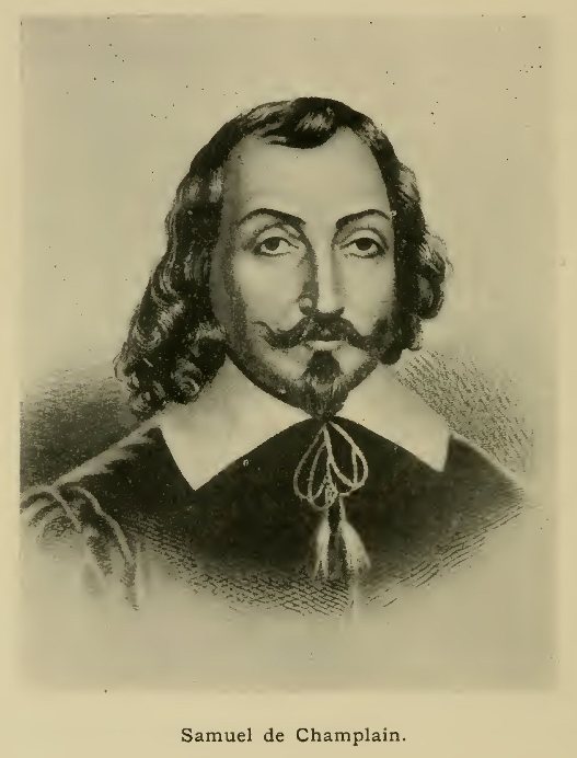
15. Samuel de Champlain. From Shea's copy of the portrait by Hamel (after Montcornet) in the Parliament House at Ottawa. (By permission of Mr Francis Edwards)
16. The Bison as figured by Hennepin. From his Nouvelle Découverte, 1697. (Facsimile)
17. Hennepin's Map, lower portion. From his Nouvelle Découverte, 1697. (Facsimile)
18. Sketch-map of the Upper Amur Region
19. The Rhubarb of China. From Kircher's China Illustrata, 1667
20. D'Anville's Map of the Chinese Empire. From his Atlas. (Outline Sketch)
21. Western Portion of Ludolf's Map of Abyssinia. From his Historia Æthiopica, 1681. (Facsimile)
22. Evolution of Central African Cartography in the 16th century. (Sketch-maps)
23. African Elephant. From Labat's Nouvelle Relation de l'Afrique Occidentale, 1728
24. D'Anville's Map of Angola, etc. From Labat's Relation de l'Ethiopie Occidentale, 1732
25. The Galapagos, by Eaton and Cowley. From Hacke's Collection of Original Voyages, 1699
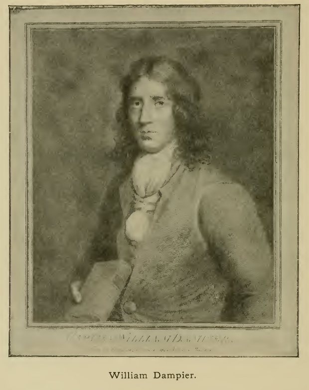
26. William Dampier. After an Original in the British Museum
27. Dampier's discoveries in the New Guinea Region. From the chart in his Travels. (Facsimile)
28. Surrender of Tahiti to Wallis. From Hawkesworth's Voyages, 1773
29. Carteret's discoveries East of New Guinea. From the chart in Hawkesworth's Voyages
30. Captain Cook. From a negative lent by Mr Murray of the Portrait in Greenwich Hospital; reproduced by permission of the Lords Commissioners of the Admiralty
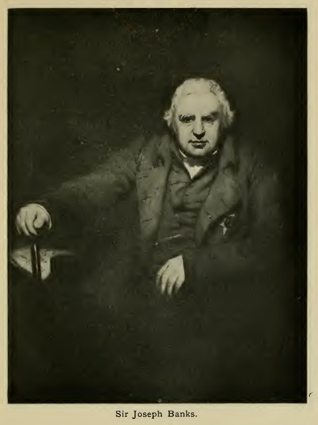
31. Sir Joseph Banks. From the Portrait in the National Gallery
32. Cook's Chart of the East Coast of Australia. From Hawkesworth's Voyages. (Outline Sketch)
33. The Resolution. From a drawing in the possession of the Royal Geographical Society
34. The Resolution among Icebergs. From the narrative of Cook's Second Voyage
35. The Sea Otter. Drawing by Webber, in the narrative of Cook's Third Voyage
36. Cook's Routes. Based, by permission, on the Chart in Kitson's Captain Cook
37. Sketch-map of North-eastern Siberia
38. Sketch-map of North-western Siberia
39. The Bering Strait Region. From Müller's Map of 1754—58. (Outline Sketch)
40. Loss of boats at the Port des Français. From the Atlas to La Pérouse's voyage
41. La Pérouse's routes in the seas north of Japan. (Outline sketch of his chart)
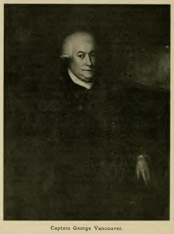
42. Captain George Vancouver. From the Portrait in the National Gallery
43. Section of Vancouver's General Chart of N.W. America. From the Atlas to his Voyage
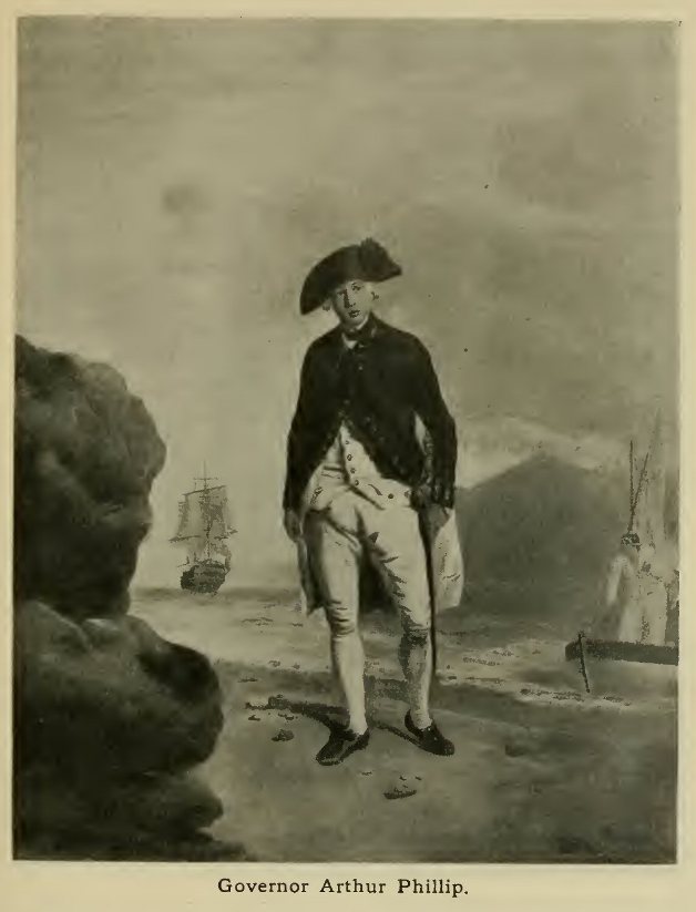
44. Governor Arthur Phillip. From the Portrait in the National Gallery
45. The Island Groups of the Western Pacific. (Sketch-chart)
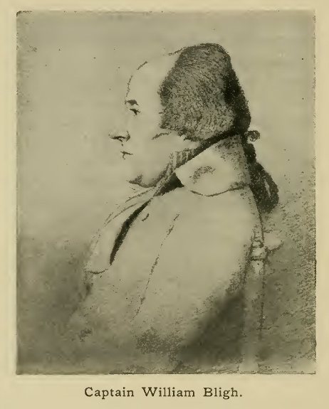
46. Captain William Bligh. From the Portrait by Dance in the National Gallery
47. The Great Slave Lake in Winter. From Hearne's Journey to the Northern Ocean
48. Alexander Mackenzie. From the engraving by Condé, after Lawrence, in his Voyages
49. Western Portion of Mackenzie's Map, showing his routes. From his Voyages. (Outline Sketch)
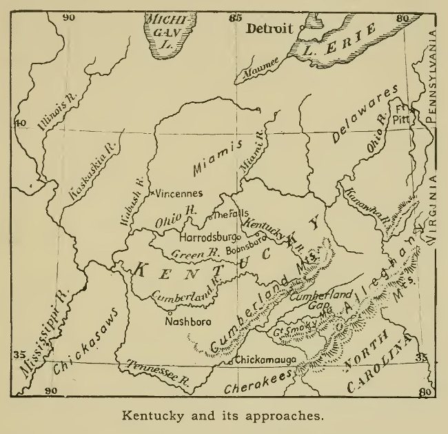
50. Kentucky and its approaches. (Sketch-map)
51. The Jesuit Map of Southern California. From Venegas's History of California. English edition, 1759. (Facsimile)
52. The Jesuit Map of Paraguay, by D'Anville. From the Lettres Édifiantes et Curieuses. (Outline Sketch)
53. Don Felix de Azara. From the Portrait in the Atlas to his Voyages
54. Renat's Map of Central Asia, 1738. From a facsimile in Petermanns Mitteilungen, 1911. (Outline Sketch)
55. View of Punakha, Bhutan. Sketch by Lieutenant Davis in Turner's Embassy
56. Carsten Niebuhr. From the Portrait in his Reisebeschreibung, Vol. III, 1837
57. James Bruce. From the Portrait in the National Gallery
58. Paterson's routes in South Africa. From the Map in his Narrative of Four Journeys, etc. (Outline Sketch)
59. Constantine John Phipps, Earl of Mulgrave. From the Portrait in the National Gallery
{Page 1}
The closing years of the sixteenth century formed an important turning-point in the history of the world, and, as a natural consequence, in the more special field of geographical discovery also. A hundred years had elapsed since the great events which gave to the latter end of the fifteenth century its unique influence on the story of the nations—the discovery of America, and the first voyage to India round the Cape of Good Hope. During that interval Spain and Portugal, the pioneers in the new movement towards world-wide empire and commerce, had attained a degree of expansion unknown since the days of the Roman Empire, and, in virtue of the famous Bull of Pope Alexander VI, had practically divided the extra-European world between them. Fleet after fleet had been despatched from their shores, straining to the utmost the too scanty resources of the two nations, reinforced though they were by the riches of Peru, and the spices and other valuable commodities of the East. Meanwhile, other nations were standing forth as possible rivals, and the arrogant claims of Spain and Portugal to exclude all others from the world's commerce did but hasten the downfall of their supremacy.
In the hope of securing a share in the East Indian trade the English long expended their energies on fruitless efforts to open a route by the frozen North, though the bold exploits of Drake and others brought them into actual collision with Spain on the ground claimed by her as her exclusive property. Private adventurers also made their way to the East, but it was not until the nautical supremacy of Spain had been broken in 1588 by the defeat of the "Invincible Armada", that the equal rights of all to the use of the maritime highways were vindicated. It was, however, not the English, but the Dutch who were the first to avail themselves of the new opportunities. After the voyages of the Portuguese had made Lisbon the chief entrepot of the valuable Indian trade, Antwerp and Amsterdam rose to importance as centres of distribution of Indian goods over Northern Europe. Rendered desperate by Spanish oppression, the seven northern provinces of the Netherlands in 1580 declared their independence, and in retaliation Philip II, under whom the whole dominions of Spain and Portugal were then united, took the short-sighted step of forbidding the Amsterdam merchants to trade with Lisbon. Threatened with ruin, they were of necessity driven to more determined efforts to obtain an independent trade with the East, and though they too, for a time, made the mistake of searching for a northern route, they soon boldly resolved to enter into open competition with the Portuguese, and in 1595-96 the first Dutch fleet sailed for India. An English expedition had, it is true, made its way to the East in 1591, but it proved unsuccessful, and it was not until 1599 that systematic steps for a direct trade with India were taken by the formation of the English East India Company.
With the change thus brought about in the distribution of material power among the nations of Europe, it was natural that geographical discovery should also in future follow a different course. Whereas the great discoveries of the fifteenth and sixteenth centuries had been almost entirely the work of Spain and Portugal, with the beginning of the seventeenth the energies of both nations became suddenly paralysed, and after the first decade of the new century no more great navigators set sail from their shores. Their place was taken by the Dutch, French, and English; the Dutch especially—who, as already stated, had gained a start on the English in the matter of Eastern trade—leading the way, during the early part of the new period, in the path of maritime discovery. But although the French lagged somewhat behind, as compared with the Dutch and English, in the prosecution of Eastern enterprises, they were destined to play an important part in the exploration of the New World, especially in North America, to which their view had been directed from an early period, even in the sixteenth century. By a curious coincidence the Russians were simultaneously entering upon a new period of activity in the broad regions of northern Asia. It was to these four nations therefore that the principal work in completing the geographical picture of the world in its broad outlines was now to fall.
Before proceeding to describe the course of discovery under the new order of things, it will be well to take a rapid survey of the state of knowledge of the globe existing at the close of the sixteenth century, and of the ideas which then prevailed respecting the still unknown portions.
As regards the knowledge of the general distribution of land and water, a marked improvement had taken place during the latter half of the century. America, after the voyage of Magellan across the Pacific, had slowly taken its fitting place as an independent division of the land, being now regarded neither as an insular mass of comparatively small area, as had been supposed by the mapmakers of the opening years of the century, nor as stretching across the North Pacific in a comparatively low latitude to join the eastern parts of Asia, as had been shown on maps dating from the middle of the century. The idea of a narrow strait separating the two continents in the far north was already gaining ground, though based apparently on a quite insufficient foundation.
Much less had been done to clear up the uncertainties respecting the supposed Great Southern Continent, which had from very early times appealed to the imagination of philosophers, and the investigation of which was the most important piece of geographical work remaining to be done. Even before the voyage of Magellan, geographers had a strong belief in the existence of land beyond the southern ocean, and this was greatly strengthened by the passage of that navigator through the strait which bears his name, as it was naturally imagined that the land to the south of the strait formed part of a great continental mass. Whether or not the ancient and medieval geographers had to any extent based their ideas on vague rumours of Australia which may have reached the countries of southern Asia, is a question which cannot be answered; but it has been held with some show of reason that statements of Marco Polo, Varthema, and other travellers, point to a knowledge that an extensive land did lie to the south of the Malay Archipelago. It is an almost equally difficult matter, and one which concerns our present subject more nearly, to decide whether the indications of a continental land immediately to the south of the Archipelago, to be found in maps of the sixteenth century, were based at all on actual voyages of European navigators. The influence of the writings of former travellers and investigators is still seen in many of these maps. Thus the term "Regio Patalis", which occurs on many of the earlier maps as the designation of a southern land, is known to have been borrowed from early writers. In the maps of the Flemish school of cartographers—Ortelius, Mercator, and others—a continental land is vaguely shown, but the details respecting it are merely borrowed from Marco Polo. A special point, however, about these maps is that New Guinea is correctly shown as an island separated by a narrow strait from the main mass of land, although it is stated in one at least that their relation was still uncertain.
An apparently stronger argument for the view that Australia had been reached during the first half of the century is supplied by a series of manuscript maps by a French school of cartographers (of which the best known representative was Pierre Desceliers), the earliest possibly dating from 1530. They all show, immediately to the south of Java, and separated from it only by a narrow channel, a vast land bearing the name Jave la grande. The details inserted on the coast line, though fairly full, are of little use for purposes of identification; but from some slight resemblance of the contours to those of Australia, and from the vast size of the land portrayed, it has been held that the maps in question prove that an actual discovery had been made.
The unsupported evidence of these maps—which in other outlying parts of the world contain many hypothetical details—can, however, be hardly said to justify any positive conclusion, and it may even be possible that some rough sketch of Java (then commonly known by Polo's designation "Java major") may have been used to supply the outline and terminology of the supposed continental land.[1] However this may be, it is certain that such a discovery was not generally known, and we may consider that to all intents and purposes the work of exploration in this direction had to start from the beginning in the period with which we have to deal. Elsewhere, though vast tracts remained a blank on the maps, the work of discovery did not set out, at the beginning of the seventeenth century, with quite such a clear field. We will take the various quarters of the globe in order, and note briefly the extent of knowledge possessed at the time with respect to each, and the chief tasks still to be accomplished.
[1 The recently discovered Carta Marina of Waldseemüller (1516) has a representation of Java which may be regarded as a first step towards the Great Java of the French maps.]
The extensive exploration of Europe may be said to have been completed by the close of the sixteenth century. Such fantastic forms as had been given to the northern parts of the continent, including the British Islands, in maps of the early part of the century, and even in the famous map of Olaus Magnus of 1539 (though this showed a great improvement on its predecessors), had given place to more correct outlines, thanks principally to the English voyages of Willoughby, Chancellor, Burroughs and others, and the Dutch voyages of Nai, Tetgales, and Barents in 1594-96. The copies of Barents' own map, published at Amsterdam in 1599 and 1611, show well the advance that had been made in the previous half-century (see p. 26). Russia too, though still imperfectly known to the rest of Europe, had been rescued from the obscurity hitherto enveloping it by the work of Von Herberstein (1549), as well as by the travels of Giles Fletcher, Queen Elizabeth's ambassador to the Czar (1588), and of Anthony Jenkinson and other agents of the British Muscovy Company.
The knowledge of Asia attained before the end of the sixteenth century may be considered under three heads. Firstly, that acquired by medieval travellers before the voyage of Vasco da Gama; secondly, that due to the voyages of the Portuguese and others by the sea route to India; and thirdly, the somewhat vague information respecting northern Asia acquired by Russian and Finnish merchants and voyagers during the course of the century. The first of these sources had supplied more or less detailed information respecting the whole of Asia south of Siberia, but the absence of accurate maps or scientific description caused much confusion of ideas with respect to it. For the southern and south-eastern countries, especially the coast-lines, this information was now superseded by the results of recent voyages, though, as we have seen, the statements of the early travellers continued to exercise a powerful influence with map-makers and cosmographers in Europe, if not with the voyagers themselves. For the whole of Central Asia, however, as well as the interior of China, the writings of Friar Odoric, Willem de Rubruk, Marco Polo, and the early missionary friars, remained the only sources of knowledge, and could at best present a most imperfect picture of those vast regions. In the south and east the Portuguese voyages (recorded in the history of De Barros and the poems of Camoens) had before the close of the sixteenth century re-opened to the world a knowledge of the whole coast-line as far as the north of China and the Japanese islands. The greater part of the Malay Archipelago had become well known, including the northern coasts of New Guinea: but whether the southern coast of the great island had been explored is uncertain, the statement by Wytfliet that a strait existed between it and a land to the south being possibly based only on Mercator's theoretical representation. Some information had also been supplied regarding the various kingdoms of India and Indo-China by the travels of Duarte Barbosa, Caesar Frederik, Gasparo Balbi, Ralph Fitch, Jan Huyghen van Linschoten, and others, some of these having reached India overland, and thus contributed to a better knowledge of the countries of western Asia. The extensive travels of Fernão Mendez Pinto, though not published till the beginning of the next century, were carried out during the sixteenth, and, in spite of much exaggeration on the part of the traveller, threw considerable light on the state of the East in his time. Lastly, in Northern Asia, the newly awakened enterprise of Russian and other merchants had begun to make known the western parts of Siberia, including the coasts of the Arctic Ocean as far as the mouth of the Yenesei. The state of knowledge of this region at the beginning of the new century is shown by the map by Isaac Massa published in Holland in 1612. But the great advance of fur-hunters and of others across the wilds of Siberia was only just beginning, and the discovery and conquest of that vast region belongs almost entirely to the period dealt with in the following pages.
In Africa, the end of the sixteenth century marks the close of a period of activity, to be followed by nearly two centuries of stagnation, so far as geographical discovery is concerned. The entire coasts were of course known, and in places, such as Benin, the acquaintance with the lands immediately in their rear was closer than was the case in our own times until quite recent years. There is no doubt, too, that some knowledge of the interior was possessed by the Portuguese at the time we are treating of, though to determine exactly the extent of that knowledge is a task of great difficulty, if not impossible, with the limited material we now possess. From the fact that maps of the fifteenth and sixteenth centuries show the African interior filled in with lakes and rivers such as are now known to exist there, it has even been imagined that the Portuguese of those days possessed an intimate knowledge of Central African geography, rivalling that due to the explorers of the nineteenth century. It is necessary briefly to examine the basis of this idea, which we shall find a very unsubstantial one. The earlier cartographers of the sixteenth century (Waldseemüller, Ribeiro, and others) merely followed Ptolemy's account, and made the Nile rise from two or more lakes lying east and west a long way south of the Equator. In course of time, however, the vague information gleaned by the Portuguese on the east and west coasts seems to have been combined with the older conjectural geography. From Congo and Angola on the west, and Mozambique, Sofala, and Abyssinia on the east, rumours of lakes and empires reached the ears of travellers, and when these were put down on the maps with considerable exaggeration of distances, the whole interior became filled with detail, and names heard of from the opposite ends of the continent became confusedly mixed in the centre of it. The maps of Mercator (1541 and 1569), Gastaldi (1548), Ramusio (1550), and Ortelius (1570) are among the earliest examples of this type, all showing the Nile as rising from two great lakes lying east and west, south of the Equator. The well-known map of Filippo Pigafetta (1591), based on the accounts of Duarte Lopez, was evidently evolved in much the same way, though the lakes there appear north and south of each other. In all these maps the greater part of the geography represented is unmistakably Abyssinian (see sketches on p. 150).
In other quarters the knowledge of the Portuguese was probably confined to the districts closely adjoining their colonies of Angola, Mozambique, and Sofala. Behind the two last named, expeditions had been pushed to a considerable distance, and Portuguese envoys had reached the country of the celebrated chief known as the Monomotapa, south of the central Zambezi. The power of this potentate became greatly exaggerated and he was supposed to rule over an empire equal to those of Asiatic monarchs. The Portuguese writers were acquainted with the famous ruins at Zimbabwe, which place the Jesuit priests are even supposed to have visited; but this appears doubtful, as the name Zimbabwe was then applied to the residence of any important chief. The gold-producing region of Manica had certainly been visited before the end of the sixteenth century, and ruined forts now existing prove that the Portuguese occupation extended to the Inyaga country, a little further north, and was not confined to the Zambezi valley. On that river itself their knowledge seems to have extended about to the site of the present post of Zumbo, at the confluence of the Loangwa.
In South America, discovery had made vast strides during the century following the first arrival of white men. Within the first 50 years the whole contour of the coasts had been brought to light, though as the passage round Cape Horn had not been made before the close of the century it was still supposed by some that Tierra del Fuego formed part of a great southern continent. Before the new century began, the range of the Andes, with the important empires occupying its broad uplands, had been made known by the conquests of the great Spanish captains, while explorers of the same nation had also traced the general courses of the three largest rivers of the continent. By the voyage of Orellana in 1540-41, followed twenty years later by that of the tyrant Aguirre, almost the whole of the course of the Amazon had been laid down. In the system of the Plata the Spanish governors Mendoza and Alvar Nuñez had ascended the Paraguay, penetrating almost to the frontiers of Peru, besides forcing a way from the coast to the upper Paraná. Of the Orinoco, the shortest of the three, less had been explored, as the cataract of Atures had turned back more than one adventurous voyager. Its western tributary, the Meta, had, however, been ascended for some distance, and the wide plains at the eastern foot of the Andes of New Granada, about which our information is even at the present day far from perfect, had been traversed again and again by searchers after the fabulous city of "El Dorado"—the Golden Monarch. These included German adventurers like Georg von Speier, Nicholas Federmann, and Philip von Huten, as well as Spanish captains like Hernan Perez de Quesada and Antonio de Berrio. Under the latter the site of the city changed its locality, and the southern tributary of the Orinoco, the Caroni, became the imagined channel of access to its fabled lake; but little success attended his efforts to penetrate in this direction. Nor did much increase of knowledge result from the voyages of Ralegh and other Englishmen to the same regions. In spite of all this activity vast tracts of forest, especially in the Amazon basin, remained unexplored, and the whole southern extremity of the continent was entirely neglected whilst, even where travellers had penetrated, the geographical knowledge obtained was often of the vaguest, and imaginary delineations of lakes and rivers long filled the maps.
In North America much less progress had been made in the work of discovery. While the coasts facing the Atlantic up to the threshold of the Arctic regions had gradually been surveyed by voyagers of various nations, and a few had pushed up the remote Pacific coasts as far as Lat. 42° N., the whole of the northern and north-western shores—the former by reason of their icy barrier, the latter because of their distance from Europe—still remained unknown, though, as already stated, ideas of the existence of a strait separating north-west America from Asia began to be current about this time. The whole of the northern and central interior, too, remained a blank on the map, and only on the confines of the Spanish viceroyalty of Mexico had any progress in land exploration been made. The example of the wealth of Mexico had led adventurers to roam the wide plains of the southern United States in search of fortune, and the expeditions of De Soto, Coronado, and others had made known something of the lower Mississippi and its tributaries, and of the more western regions up to the Grand Cañon of the Colorado. But the absence of rich empires in this direction soon caused these efforts to be abandoned. In Florida, unsuccessful attempts at a settlement had been made by French protestants, and further north, in Virginia, the first beginnings of the English settlements destined to grow in time to such vast proportions were in existence. Still further north, off the coasts of Newfoundland, French, Spanish, Portuguese, and English ships frequented the banks in large numbers for the sake of the fishery, and the French under Cartier had already led the way in discovery by the ascent of the St Lawrence beyond the present site of Quebec, soon to be the scene of colonising efforts on the part of their countrymen. A wide field for discovery was thus open in eastern North America, and the coming century was to witness a well-sustained activity, leading to a great enlargement of the bounds of geographical knowledge.
In the wide domain of the Pacific Ocean much remained to be done, though fairly correct ideas as to its nature and extent had become current. Since the voyage of Magellan many Spanish navigators had crossed from the coast of America to the islands of the Eastern Archipelago, to which this was their regular route, owing to the division of the world between Spain and Portugal, the return voyage being made across the North Pacific in fairly high latitudes. From Callao in Peru Mendaña had twice crossed the ocean in about 10° S., discovering the Solomon and Santa Cruz groups and supplying apparent confirmation of the ideas then current as to the existence of a southern continent. On the second voyage he had been accompanied by the celebrated navigator Quiros, whose own chief work fell within the new century, and will be dealt with in the following pages. Other Spanish navigators had crossed the ocean north of the Equator from Mexico to the Philippines, and it has been supposed that Gaetano—the pilot who accompanied one of these, Villalobos, in 1542—afterwards made a voyage to the Sandwich Islands. But this discovery, if made, was carefully kept secret, and had no influence on the subsequent history of Pacific exploration. The Englishmen Drake and Cavendish had likewise crossed the Northern Pacific, and just at the close of the century the Dutch expedition under Van Noort had followed in the tracks of Magellan and for the fourth time effected the circumnavigation of the globe—but this belongs rather to the new than to the old period. In most of these voyages certain definite routes had been followed, which missed many of the most important groups of islands. The information brought home with respect to those seen was very vague and fragmentary, and for the most part they can with difficulty be now identified. Both in the north and south, vast expanses of ocean remained untraversed, and the exploration of these, especially in the south, was one of the principal tasks of the coming century.
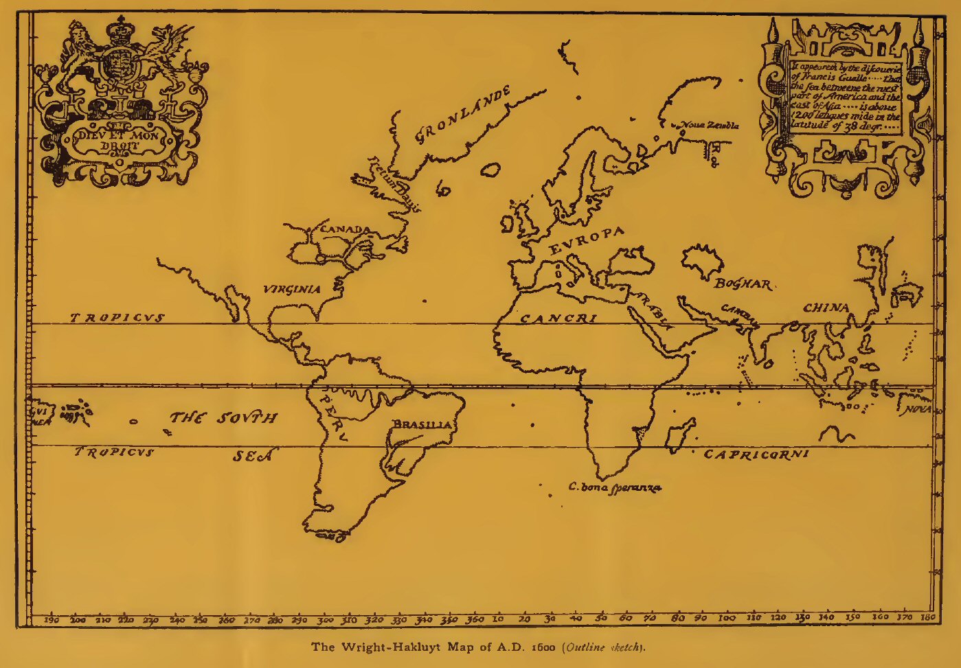
The Wright-Hakluyt Map of A.D. 1600 (Outline
sketch).
Click on the map to enlarge it.
In the Arctic regions some advance had already been made before the close of the sixteenth century, the new period having in fact been ushered in by the early enterprise of the English and Dutch in this quarter, from about 1550 onwards. In dealing with this part of the world it will be advisable to go back to about that date, so as to give a more connected account of the progress achieved; and it is unnecessary to enter into the subject here.
Title of the Wright-Hakluyt Map of A.D. 1600.
The state of knowledge respecting the world in general at the close of the sixteenth century is well shown by the map prepared under the superintendence of Edward Wright, the Cambridge mathematician, to whom the projection now known as Mercator's is held to be really due. This map, finished in 1600, and sometimes found inserted in the edition of Hakluyt's famous collection of voyages completed in that year, is the earliest English example of that projection. It differs from many maps of the time in its careful discrimination between actual discovery and conjectural geography, the latter being almost entirely excluded. Thus no trace is seen of the hypothetical southern continent, apart from a slight indication of land in the position of northern Australia. The recent Arctic discoveries are well shown, and it has been thought that John Davis had some share in its preparation. The strait which bears his name is correctly drawn, as well as the discoveries of Barents in Spitsbergen and Novaya Zemlya. In the Far East, too—whence, as we shall see later, Davis had recently returned—the map gives a very correct representation of the Archipelago, Japan, etc. North of the Pacific a wide blank occurs between the coasts of Asia and America, the conjectural connection between the two, and the equally doubtful Strait of Anian shown on so many maps of the period, being alike omitted. Another type of map, current about this time, is represented by that of Ortelius, a reduced copy of which, prepared by Girolamo Porro for Magini's Ptolemy of 1596, is here reproduced from the Italian version of 1598. It will be noticed that the supposed southern continent here takes a prominent place.
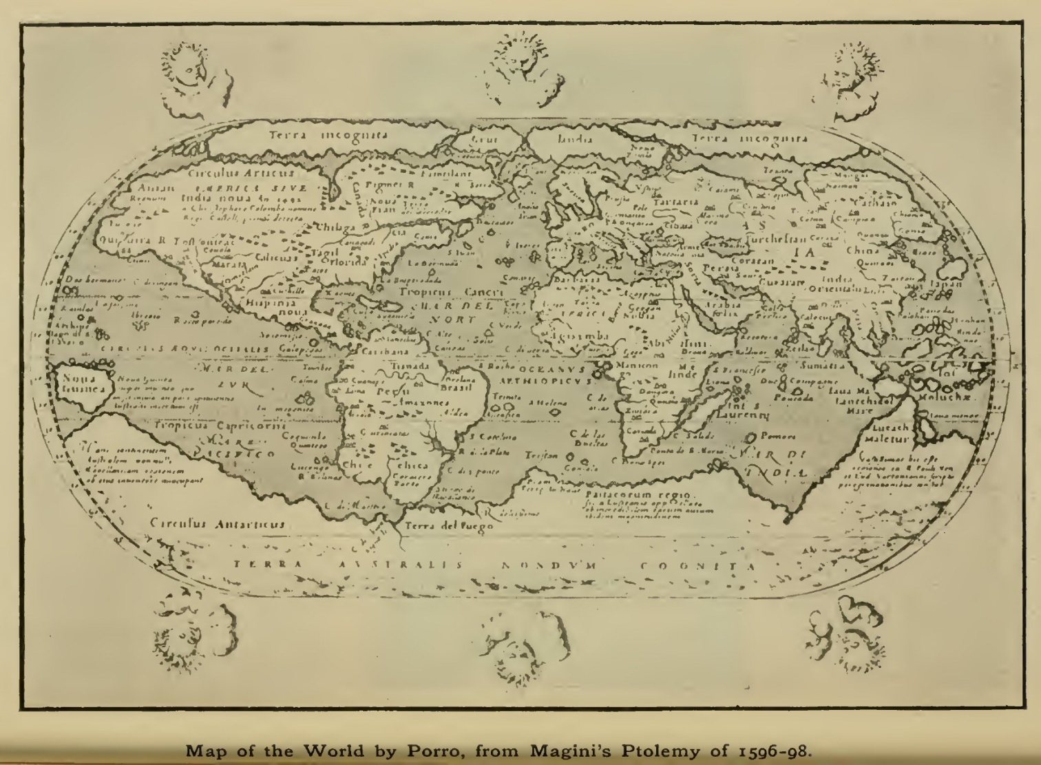
Map of the World by Porro, from Magini's Ptolemy of
1596-98.
Click on the map to enlarge it.
{Page 14}
In the remarkable outburst of maritime enterprise which followed the discovery of America, it was the equatorial regions, with their real or supposed wealth in the precious metals and other valuable commodities, which above all stimulated the energies of such nations as, by their political influence or favourable geographical position, had been called upon to take part in these adventures. But, side by side with this principal current of activity, there had begun to flow, in the course of the sixteenth century, a subsidiary stream of enterprise in the direction of the inhospitable North—a stream which, though at first but feeble in comparison, was destined to lead to results of great importance for the widening of the geographical horizon. And as it was the more southern peoples of Western Europe who had gained the chief glory and profit from the earlier quest, so it was the hardy seamen of the north who, as an equally natural result of geographical position, carried off the laurels in the still more arduous task of seeking new routes through the frozen Arctic seas.
The first beginnings of enterprise in this direction belong to still earlier times than the search for a route to the Indies, and are in fact to a great extent lost in obscurity. Long before the Venetian and Portuguese navigators began to venture into the unknown wastes of the Atlantic, the seamen of the north had carried out voyages unsurpassed for their daring even by the more fruitful exploit of Columbus. Before the end of the tenth century the most northern point of Europe seems to have been rounded by Other in the voyage narrated by him to our King Alfred, while in the following century the Norsemen (who had already colonised Iceland) found their way to the distant shores of Greenland, where, according to the story, two separate settlements were founded and existed for some centuries. They even appear to have reached some part of Eastern Canada or Newfoundland. The supposed voyages of the Venetian noblemen, Niccolo and Antonio Zeno, in the fourteenth century, have been proved almost with certainty to have been mainly, if not entirely, fictitious; but that some glimmering of knowledge of these northern regions was possessed by the cartographers of the following century is shown by various maps that have come down to us, especially that of Claudius Clavus, the "earliest cartographer of the North." The rising spirit of maritime adventure found its first outlet in England in the voyages of the Cabots, father and son, though those of Sebastian, the son, have not yet been satisfactorily elucidated, and the idea once held that they reached as far north as the mouth of Hudson Strait rests on no sure foundation. The arguments put forward by Robert Thorne in 1527, as to the feasibility of a north-west passage, led to no immediate result, and it was some years later that the English merchants took the first important step towards securing a share in the benefits of distant trade, from which the jealousy of their continental rivals had hitherto excluded them.
Mainly through the agency of Sebastian Cabot, an association was formed for "the discovery of lands, countries, and isles not before known to the English", and this received a royal charter in 1549.[1] At this time the thoughts of the merchants were directed chiefly to the opening up of trade with the East by way of Northern Russia, and for this purpose an expedition of three ships was fitted out in 1553 and despatched under the command of Sir Hugh Willoughby, with Richard Chancellor as "pilot-major." It was furnished with "letters missive" from King Edward VI to the potentates of the regions likely to be visited, and sailed from Ratcliffe on the Thames, full of high anticipation, on May 10, 1553. But it was doomed to meet with disaster. After sailing along the coast of Norway the ships encountered boisterous weather, and two of them, the Bona Esperanza and Bona Confidentia (the former Willoughby's own ship), were driven hither and thither, and though they sighted land in the latitude of 72° (probably on the south-west coast of Novaya Zemlya), were finally forced to take refuge in the haven of Arzina [2] in Lapland, where the whole of the crews perished miserably of cold and hunger. The third ship—the Edward Bonaventure, with Chancellor for captain, became separated from the others and succeeded in reaching the mouth of the Dwina in the White Sea, whence Chancellor and some of his companions travelled inland to Moscow, and were well received by the Emperor Ivan Vassilivich, thus paving the way for future trade relations between Great Britain and Russia. On his return Chancellor wrote a short account of the country and the manners and customs of its people—the earliest first-hand information on the subject which reached this country. He was drowned when returning from a later voyage in 1556.
[1 In the successive charters granted to this association of merchants, the title given to it varies considerably, giving rise to some confusion. It was for a time most generally known as the "Company of Merchant Adventurers", but this gave place in an act of parliament of 1556 to "The Fellowship of English Merchants for Discovery of New Trades", while the more commonly used title was that of the Russia or Muscovy Company.]
[2 The Varzina river debouches on the north side of the Kola peninsula in about 38½° E. It is already shown on Ortelius's map of Europe.]
In 1555 a second voyage was made, and trade definitely established, while in 1556 the Company despatched Stephen Burrough, in the pinnace Searchthrift, to explore still further east in the direction of the river Ob. Burrough reached Vaigatz Island on July 31, and soon afterwards entered the Kara Strait between that island and Novaya Zemlya, which has been sometimes known, from him, as Burrough Strait. He was unable however to advance any distance into the Kara Sea, but turned back on August 5, wintering at Kolmogro at the mouth of the Dwina.

Novaya Zemlya, showing entrances to Kara Sea.
The success of the trade with Russia diverted the energies of the merchants from the search for a north-east passage for some years, and it was not until 1580 that any serious attempt was made to prosecute discovery in this direction, attention having meanwhile been once more directed to the north-western route. Yearly voyages were however made to Kolmogro, and agents were regularly established in Russia to buy up commodities in readiness for the arrival of the ships, while some made their way on behalf of the Company as far as Persia and Central Asia. Hakluyt prints the commission issued in 1568 (given as 1588 by a misprint) to three servants of the Company—Bassendine, Woodcocke, and Browne—to explore eastwards beyond the Pechora, but nothing is known of the result. In 1580 the Company determined to renew their efforts for the discovery of a north-eastern route to Cathay, and commissioned two captains, Arthur Pet of Ratcliffe and Charles Jackman of Poplar, to sail for that purpose, in the barks George and William of London, the former of 40, the latter of 20 tons only. In spite of the ill-success of Burrough's attempt, it was still hoped that by passing through the strait between Vaigatz and Novaya Zemlya, a passage might be found to China in a generally eastward direction, as indicated on a chart which had been drawn by William Burrough. With our present knowledge of the difficulties to be encountered—difficulties so great that the wished-for passage was not made until three centuries after Pet and Jackman's time—we can only wonder at the sanguine spirit which regarded it as possible that China could be reached, in the small and frail vessels employed, during the same summer in which they set out, or at worst after one winter had been spent on the northern coast of Asia.[1] It was only in case the land should be found to extend to 80° N., or even nearer the Pole, that the impossibility of the passage was thought probable. In such a case, after as much of the coast as possible had been explored during the first summer, the explorers were recommended to winter in the Ob, and ascend it the next summer to the "City of Siberia." In any case all possible care was to be taken to enter into friendly relations with the inhabitants, and lay the foundations of future trade. A point to be specially kept in view, either on the outward or return voyage, was the examination of "Willoughby's land", and its relation with Novaya Zemlya. Notes for the guidance of the voyagers were also supplied by William Burrough, Dr Dee, and Richard Hakluyt, the last dealing particularly with the commodities to be taken as specimens of English wares, and the points on which information was needed in regard to the countries visited.
[1 A representation of the northern coast of Asia current about this time, as seen in Mercator's map of 1569, was still to a large extent based on the old classical writers. It showed one decided promontory—Cape Tabin—running up into the Arctic Sea, but, beyond this, little further hindrance to a voyage to China in latitudes far lower than the reality. Cape Tabin still appears in the map of Barents's discoveries drawn by Hondius for Pontanus's History of Amsterdam (1611), of which a portion is shown on p. 26.]
Although the amount actually accomplished fell very far short of these expectations, the two captains made a determined fight against heavy odds, and only turned back after trying every means in their power of pushing east across the Kara Sea. The ships separated, after passing the "Wardhouse" (Vardoe), owing to the bad sailing of the William, but a rendezvous was arranged at Vaigatz. The first land sighted by the George seems to have been the south-west coast of Novaya Zemlya, but after vainly searching for a passage Pet went south and explored the mainland coast east of the Pechora, a part of which he took to be the island of Vaigatz. Going north again a meeting was happily effected with the William, and the two ships entered the Kara Sea either through Yugor Shar, the narrow strait between Vaigatz and the mainland, or through the broad opening north of Vaigatz already discovered by Burrough.[1] They were constantly beset by ice and baffled by fog, till at length, after vain endeavours to make headway, the navigators turned their faces homewards, only escaping from the ice with much difficulty. Further dangers were encountered on the shoals of Kolguev Island, and the ships again separated, the George safely reaching Ratcliffe on December 26, 1580, while Jackman, in the William, after wintering on the coast of Norway, set out in the following February towards Iceland in company with a Danish ship, and was never again heard of.
[1 It has been generally held by English writers that the passage was made by Yugor Shar, which has therefore been often known as Pet's Strait, but reasons were put forward by Baron von Nordenskiöld for supposing that the route was to the west and north of Vaigatz.]
Pet and Jackman deserve great credit for the boldness with which they fought their way through the ice-pack of the Kara Sea, as well as for their judgment and resource in availing themselves of any opening which promised to afford a passage. The difficulties of this navigation have baffled many a voyager even in modern times, and it is no matter for surprise that with their small advantages they were unsuccessful in pushing further east. Little serious effort in this direction seems to have been made by the Muscovy Company for some years after this, though a rumour was current about 1584 that an English vessel had previously been lost at the mouth of the Ob, and its crew murdered; while information obtained in that year by Anthony Marsh, one of the Company's factors, points to a knowledge on the part of the Russians at this time of Matyuskin Shar, the strait between the two large islands of Novaya Zemlya.
The search for the north-east passage was now taken up with much zeal by the Dutch, whose heroic attempts to open up the much desired route must now be spoken of, before recurring to the efforts of the Muscovy Company. The first Dutch voyage to the extreme north of Europe seems to have been made in 1565, when a trading post was established at a spot to which the name Kola was given. It is but little after this that we first meet with Olivier (or Oliver) Brunei, a man who took no small part in the further prosecution of Dutch northern enterprise, though himself a native of Brussels. Having undertaken a voyage from Kola to Kolmogro on the White Sea, he was made prisoner by the Russians, apparently at the instigation of the English, and remained so for several years. Being at last liberated through the good offices of the Anikieffs, Russian merchants associated with the Strogonoffs, he made several journeys of exploration on their behalf in the direction of the Ob, visiting Kostin Shar on one occasion. He helped to establish mutual trade relations between Holland and Russia, and eventually secured the support of the famous merchant De Moucheron for a voyage of discovery. Brunei set out in a ship of Enkhuysen in 1584, but met with no success, being baffled in an attempt to pass through Yugor Shar, and losing his ship, with a cargo of furs, etc., in the mouth of the Pechora. He is said to have afterwards entered the service of the King of Denmark, and possibly took part in the voyage of John Knight to Greenland in 1606.
The town of Enkhuysen, which thus had the honour of leading the way in the Dutch voyages of northern discovery, was not long in organising another attempt in the same direction. Among its citizens were several men who had interested themselves in geographical and commercial matters, including the famous Linschoten (whose long residence in the East Indies made him the foremost authority on all matters connected with the eastern trade of the Portuguese) and Cornelis Nai, an experienced seaman. The Middelburg merchant De Moucheron continued to turn his thoughts to the north-eastern route, and the divine and geographer Peter Plancius was a zealous advocate of further enterprise. He did much to improve his countrymen's knowledge of navigation, and among his pupils were Willem Barents and Jacob van Heemskerk, each destined to play an important part in northern discovery. Both were capable seamen, especially Barents, who seems, like John Davis in England, to have been well versed in the science of navigation.[1] In 1594 two vessels were fitted out—the Swan, commanded by Cornelis Nai, and the Mercury, by Brant Tetgales, both natives of Enkhuysen. With Tetgales Linschoten went as commercial agent. At the same time the merchants of Amsterdam decided to take part in the enterprise, and fitted out a third vessel—also named the Mercury—and this was placed under the command of Barents,[2] with whom a small fishing-boat from Terschelling also sailed. The plans laid down by the Amsterdam adventurers differed from those of the men of Enkhuysen, the former considering that a route round the north coast of Novaya Zemlya would offer the greatest prospects of success, while the latter adhered to the idea of entering the Kara Sea through one of the straits separating the several islands. As we have seen, some knowledge of Matyuskin Shar seems to have been gained by the Russians before this date, but the greater part of the coasts of the northern island were certainly unknown, so that the attempt to sail round its northern end betokened great hardihood, though quite justified by the measure of success now and subsequently attained by this route.
[1 Either he, or a contemporary of like name, was author of a sailing directory for the coasts of the Mediterranean.]
[2 The full name of the navigator was Barentszoon, contracted by the Dutch to Barentsz, but the form Barents may conveniently be retained in English. Nai is sometimes spoken of merely as Cornelis Corneliszoon.]
Almost the whole of the voyage was made independently by the two parties, though all the vessels met at a rendezvous at Kildin, in Lapland, towards the end of June. On the 29th, Barents sailed for Novaya Zemlya, which was sighted on July 4 in 73° 25' N., and followed northward to Cape Nassau, which was reached on the loth. Now began a heroic struggle to advance through the ice, which was here encountered in great quantities. It has been calculated that the various courses run by Barents on this coast make up a total of over 1600 nautical miles, the furthest point reached (July 31) being near the Orange Islands. The men now grew discouraged, and seeing but slight probability of accomplishing the object of the voyage, Barents reluctantly agreed to turn back. On August 15 he reached the islands "Matfloe and Dolgoy" (Matthew Island and Long Island) to the S.S.W. of Vaigatz, and fell in with the other captains, who had likewise returned from an ineffectual attempt to push eastward to the Ob. They had sailed through Yugor Shar, to which they gave the name Nassau Strait, being the first navigators, with the doubtful exception of Pet, to pass through this passage into the Kara Sea. They claimed to have sailed eastward as far as the meridian of the mouth of the Ob, but as the distance given is only 50 to 60 Dutch miles (each equal to four geographical miles), this can hardly have been the case. All four vessels now sailed home together, reaching their respective destinations about the end of September.
The report made by Linschoten after the return of the voyagers estimated the chances of future success more favourably than was perhaps justified, and this encouraged the merchants to set on foot a more ambitious undertaking for the following year. Seven vessels took part in it, and this time the Amsterdam merchants were willing to combine with those of the other towns interested, their two ships being placed, like the rest, under the command of Nai, who was appointed admiral of the whole fleet. He sailed in the Griffin of Zeelandt, while Tetgales and Barents commanded, respectively, the Hope of Enkhuysen and the Greyhound of Amsterdam (both new war pinnaces), Barents also undertaking the post of chief pilot of the fleet. The chief commercial agents were Linschoten, who again represented the merchants of Enkhuysen, etc., and François de la Dale, who looked after the Moucheron interests. It was arranged that one of the smaller vessels, a yacht of Rotterdam, should return alone with the news, in case of a successful rounding of Cape Tabin, still supposed to be the crucial point of the whole navigation, the remainder of the passage to China being thought comparatively short and easy. As on the former voyage, a Slav named Spindler went as interpreter, to facilitate the hoped-for intercourse with the peoples of Eastern Asia. The fleet sailed on July 2, 1595, and on the 19th of the same month approached Yugor Shar, having the day before passed Matthew Island ("Matfloe"). The strait was blocked by immense masses of ice, and it soon became evident that its passage would be a matter of unusual difficulty, if not quite impossible. The ships anchored in a bay on the Vaigatz side, behind the point known to the Dutch as Idol Point (not to be confounded with the spot at which Samoyed idols were found by Burrough, which was at the northern end of Vaigatz), and thence an examination of the strait was made both by sea and land, but with little success. Barents appears to have been the most energetic of the captains in his efforts to find a passage, and he repeatedly renewed his attempts when the rest were ready to abandon the task as hopeless. But after immense exertions, which brought the ships only a small part of the way through the strait, the outcome of various councils was that the men of Amsterdam, whose obstinacy seems to have given some offence to their fellow-adventurers, at last agreed to turn back and joined in a protest signed by all the captains and the two commercial agents, declaring that all had done their utmost to fulfil their commission, and that the only course open to them was to sail homewards. Thus ended the voyage on which such great expectations had been built, but which had in reality met with much less success than many of the previous ventures, owing, it is true, to the unusual severity of the season, which had kept the ice in the Yugor Strait packed into a solid mass throughout the summer.

Boats' adventure with a polar bear.
(From De Veer's narrative of Barents's
Voyages.)
In spite of the ill-success of the expedition of 1595, the merchants of Amsterdam, encouraged no doubt by the ardour and sanguine spirit shown by Barents, were ready to make yet another attempt in the following year. It was the belief of Barents, founded on his experiences during the voyage of 1594, that the greatest chance of success lay with the route round the north of Novaya Zemlya, and in this he had the support of the opinion of Plancius. Being now independent of their former associates, the Amsterdam merchants were able to form their plans in accordance with these views. Two ships, the names of which are not recorded, were fitted out, and placed under the command of Jacob van Heemskerk and Jan Corneliszoon Rijp, who had been associated with Linschoten and De la Dale as commercial agents during the second voyage, Heemskerk having Barents with him as pilot and apparently leaving to him a large share in the direction of the voyage. The expedition sailed from Vlieland near Amsterdam on May 18, 1596, and in deference to the opinion of Rijp a course was steered further to the west than on the previous voyages, and this led to the discovery, on June 9, of Bear Island, long called Cherie Island by the English, being so named by Stephen Bennet seven years after its discovery by the Dutch. Here the voyagers landed, and gave the island its name from an encounter they had with a bear. Continuing their voyage towards the north, they reached the ice-pack on June 16, and after tacking to keep clear of it, found the latitude on the 17th to be 80° 10'. On the same day high, snow-covered land was sighted, which was evidently the coast of Spitsbergen, east of Hakluyt Headland (as the extreme N.W. point of the group was afterwards named by Hudson), this island group being thus brought to light for the first time in the history of discovery. Before the end of the month the west coast was explored, southwards, to 76° 50' N., the name still in use for the whole group being applied to the newly discovered land by reason of its sharp summits (though it was taken to be part of Greenland), while that of Vogel Hoek was given to the north point of the Foreland (the long island lying a little off the coast) on account of the multitude of birds there seen. The mouths of Ice Fjord and Bell Sound were also noted. Bear Island was once more reached on July 1, and here the two ships parted company, Rijp returning along the coast of Spitsbergen after a fruitless effort to push north through the sea to the east, while Heemskerk, yielding no doubt to Barents's persuasion, sailed for Novaya Zemlya.[1] The farthest point of the voyage of 1594 was successfully passed, the north-eastern promontory of the group being rounded and a bay reached on the east coast which received the name of Ice Haven. Here the ship was beset, and the navigators were forced to spend the winter in great misery. A house was built of drift-wood, which gave them some shelter from the cold, but scurvy broke out and caused much suffering, Barents himself being one of those most severely attacked. Time wore on, but summer approached without any prospect of the release of the ship. It therefore became necessary to attempt the homeward voyage with no better resource than two open boats, in which, on June 13, they embarked, fifteen in all, Barents and another man being still very ill. On June 20, when with incredible difficulties they were making their way down the west coast of Novaya Zemlya, the indomitable navigator, who had done more than any other to keep alive the hope of effecting the north-east passage, breathed his last, and two others of his comrades soon shared his fate. The survivors at length reached open water, and having obtained some help from two Russian vessels met with on July 28, made their way to Kola, where they found three Dutch ships, one of them commanded by their old comrade Rijp, who took them home to Holland.
[1 See additional note on Rijp at the end of the volume.]
The feat thus accomplished ranks among the hardiest achievements of Polar exploration. For the first time a party of men had wintered far within the Arctic Circle, suffering all the hardships inseparable from such a first experience, without any of the comforts enjoyed by those who have since followed in their footsteps. No other navigator visited their desolate wintering place until nearly three centuries later, when, in 1871, Captain Carlsen landed there and found the hut still standing, and various relics which had been left in it when abandoned by the early explorers. The death of Barents—perhaps the most hardy and capable navigator ever produced by Holland—was a great loss to the cause of Polar discovery, and the small success achieved naturally led to a cessation, for the time being, of the Dutch search for a passage. The next attempt was to be made by the English in the person of Henry Hudson.

Part of Hondius's Map of 1611, showing Barents's
Discoveries.
Click on the map to enlarge it.
Of the early life of this enterprising seaman we know absolutely nothing, and doubts have even been thrown, though with no sufficient reason, on his English nationality. In 1607 we find him in command of one of the Muscovy Company's ships—the Hopewell—which was to renew the search for a northern route to the East, on which so much energy had already been expended by the Company. The idea seems to have been to attempt the passage right across the polar area, according to a suggestion made many years earlier by Robert Thorne. Thus instead of steering for Novaya Zemlya, or even for Spitsbergen, Hudson, who sailed from Gravesend on May 1, directed his course towards the east coast of Greenland, which was sighted on June 13. The southern part of this land had already been touched at more than once during the north-west voyages—which we shall have to consider presently—as well as by Cortereal in the 16th century. But even the point where it was first struck by Hudson was some way to the north, and a still higher latitude was attained during the further voyage; though the observations of the coast, hampered as they were by the ice, did not supply any clear idea of its configuration, the land being still shown in subsequent maps as it had been in that of the Zeni and others of its type. Hudson, however, did a useful piece of work in following the edge of the ice-barrier which extends between Greenland and the neighbourhood of Spitsbergen, and proving that there was little likelihood of a passage being found through it. Spitsbergen seems to have been struck near the Vogel Hoek of Barents, while during subsequent cruises a good part of the west and north-west coasts was examined, and the names Hakluyt's Headland, Collins Cape, and Whales Bay assigned to localities on the west coast.[1] On July 23 an astronomical observation, as recorded in the journal of John Playse (practically the only authority for the voyage), gave the latitude as 80° 23', but the correctness of this is doubtful. In any case enough was done to show that no prospect offered of a passage through the ice-pack, and after sailing to and fro for some time, Hudson was forced to turn homewards, falling in accidentally during the voyage with an island (in Lat. 71°) which must have been that of Jan Mayen, but which was named by him "Hudson's Tutches" (Touches). Tilbury was finally reached on September 15. Besides the negative result as regards the wished-for passage, the voyage was important for the attention called by it to the great number of whales and walrus in the Spitsbergen-Greenland Sea, the capture of which formed the incentive for so many subsequent enterprises.
[1 Whales Bay was the opening in 79° just north of Prince Charles Foreland, Collins Cape being on its northern side.]
The failure of this attempt to pierce the northern ice-barrier did not deter the Company from renewing the search in the following year, when trial was once more made of the old route by Novaya Zemlya, Hudson being again in command, with Robert Juet as mate. Sailing from the Thames on April 22, and passing the North Cape on June 3, he navigated the sea between Spitsbergen and Novaya Zemlya, the first ice being seen on June 9, in 75° 29'. The day before, the change in the colour of the sea to a blue-black had been noted—a change which Hudson had already, in 1607, connected with the neighbourhood of ice, though the coincidence is now said to be purely accidental. For the greater part of this month the voyagers continued to beat about in this sea,[1] constantly hindered by ice from making any advance northwards. As they increased their longitude easterly, they were, in fact, compelled to lose some of their northing, and when Novaya Zemlya was sighted on June 26 near the point called Swarte Klip by the Dutch, they were as low as 72° 25'. Some time was now spent on this coast, landings being effected on several occasions and observations made of the general nature of the country, which they found less inhospitable than previous accounts had led people to suppose. Bird life was plentiful, and many deer, bears, and a fox were seen, the sea also abounding with walrus. Still going southward, they came to Kostin Shar, an inlet with an island dividing it into two branches, which had been reached by Brunei, but placed too far north and corrupted by map-makers into Costing Sarch. Here the powerful set of the current outwards gave Hudson great hopes of finding a passage to the Kara Sea, but an exploration by boat proved them fallacious. Therefore being, as he says, "out of hope to find passage by the north-east," Hudson reluctantly gave up the attempt, being "not fitted to try or prove the passage by Vaigatz," though on the return he hoped to ascertain whether Willoughby's land "were as it is layd in our cards." He also had some idea of making an attempt by the north-west, hoping to be able to run a hundred leagues or so within the sound then known as Lumley's Inlet—which may either have been Hudson Strait itself or a passage further north—and the "furious overfall" which had been seen by Davis (see p. 35). But the time being now far advanced he considered it his duty to the Company not to run unnecessary risks, and returned home, reaching Gravesend on August 26.
[1 An occurrence often referred to in connection with this part of the voyage was the supposed sighting of a mermaid—in reality, no doubt, a seal]
It was not many months before the indefatigable navigator was once more negotiating with a view to a third northern voyage, but not now under the auspices of the English Company, which seems to have lost heart after such repeated failures. The circumstances attending the inception of Hudson's voyage for the Dutch East India Company are not fully known, but the main facts can be pieced together from scattered sources. Either at the end of 1608 or the beginning of 1609 he was invited to Amsterdam to give an account of his northern experiences, and had interviews with Plancius and others; but though the Company thought that a further attempt would be worth making, they came to no immediate arrangement. Meanwhile a scheme, favoured by Isaac Le Maire, had been set on foot for the establishment of a rival company under the patronage of Henry IV of France, and the employment of Hudson on a northern venture. This led the existing company to reconsider their decision, with the result that a ship or ships [1] were equipped at once, and were ready to sail by April 6, 1609. The greater part of the crew were Dutchmen, who seem to have been indisposed to accept Hudson's authority, for after sailing for Novaya Zemlya to make trial, as a last hope, of the passage by Vaigatz, he found disaffection existing, and, the ice giving no greater promise of success than in the previous year, he decided to search for a passage along the American coast, being encouraged to do this by letters and maps sent him from Virginia by Captain Smith.[2] The result was the examination of a stretch of coast extending as far south as 37° 45', and the visiting and naming of the Hudson River. During the return dissension again prevailed, and on reaching Dartmouth on November 7, Hudson and the other Englishmen on board—among whom was Juet, to whom we owe the only detailed narrative of the voyage—were ordered by the English authorities not to leave England, but to remain to serve their own country. It was not long before arrangements were made for an English voyage to the north-west, but before speaking of this we must go back somewhat, and take up the thread of former attempts in this direction.
[1 The greater part of the voyage was made in the Half Moon, but according to statements in the minutes of meetings of the council of the Company, Hudson's ship was the Good Hope, and it has been thought that this may have sailed also, but it seems more probable that a confusion had arisen with the name of the ship in which he made his earlier voyage.]
[2 A renewed Dutch attempt by the north-east route, in 1611-12, is referred to at the end of the volume.]
The voyages of the Cabots, which led the way to the north-eastern coasts of America, were not, as we have seen, followed up for a number of years by any further efforts on the part of the British merchants. The chief credit of re-directing public attention to this route seems to belong to Sir Humphrey Gilbert, though there is little doubt that the idea of renewing the search where it had been broken off by Sebastian Cabot had been working in the minds of others, among them Martin Frobisher, to whom fell the actual task of carrying it out. In 1574 Gilbert wrote a learned discourse to show the probability that an easy route to India would be found by the north-west. While based to a large extent on mistaken premisses, it contained some shrewd ideas, and the argument for a north-west passage based on a study of oceanic circulation had in it something more than mere plausibility. In the then existing state of knowledge it was certainly more justifiable to conclude that an easy passage might be found on this than on the opposite side of the Atlantic; and that the Muscovy Company, which had all Cabot's experience at its disposal, should have so long persisted in its preference for the north-east route would be matter for surprise, were it not for the encouragement offered by the rapid development of trade with northern Russia. Gilbert's treatise was not printed till 1576, by which year Frobisher had already gained so much support, that he was able to sail from Ratcliffe on the Thames on June 7, the expedition consisting of the Gabriel, Frobisher's own ship, the Michael (Captain Matthew Kindersly), and a pinnace. The Queen had taken much interest in the preparations, and among the supporters were Michael Lok, a prominent merchant, Richard Willes,[1] and others. Having reached Foula, the westernmost of the Shetland Islands, Frobisher sailed slightly north of west, and on July 11 sighted land, which was taken to be the Frisland of the Zeno map, the observed latitude of 61° corresponding to that assigned in this to the south end of Frisland. In reality it was the southern point of Greenland, and when this had been passed, a course somewhat north of west brought the ships to a new land, with much ice along its coast. On August 11, in 63° N., Frobisher entered what he took to be the desired strait leading to the Pacific, but which was really the bay, since known by his name, running into the south-eastern extremity of Baffin Land. This was explored during several days, and communication was opened with the Eskimo of that region, who are described as "like to Tartars." But it was found impossible to proceed to the end of the bay, and on the 26th the homeward voyage was begun, Harwich being reached early in October. The new land received, from the Queen herself, the name "Meta Incognita", or the Unknown Bourne.
[1 Willes, like Gilbert, wrote a treatise to prove the probability of a north-west passage, in which he endeavoured to answer the objections of those who took the opposite view. He states these with great clearness, but his own arguments seem hardly calculated to carry conviction.]
Frobisher renewed the search in the two succeeding years (1577 and 1578), in the latter with as many as 13 ships, but without materially adding to his discoveries. His ill-success in the primary object of his voyages made him catch at any chance of deriving a profit from the venture, and he brought home a cargo of a shining mineral which he thought to contain gold, but which proved quite worthless. The promoters naturally lost heart, and Gilbert was soon occupied with the colonising schemes in the more southern parts of North America, in the prosecution of which he lost his life in 1583. But the efforts put forth were not without their ultimate result, for it was not long before others came forward to renew the enterprise, for which the discoveries of Frobisher, scanty though they had been, supplied both incentive and encouragement.
John Davis, the able navigator who was to take up the task where it had been left by Frobisher, was the son of a yeoman landowner at Sandridge in the parish of Stoke Gabriel on the Dart. Here he was a neighbour of the Gilberts, and was likewise brought into the society of their half-brother, Sir Walter Ralegh. Having probably been accustomed to the sea from his early youth, his advice was naturally sought by the promoters of voyages of discovery, among whom Adrian Gilbert, the younger brother of Sir Humphrey, took a prominent place after his brother's death. Another associate was Dr John Dee, the mathematician. In 1585 a new scheme took shape, the necessary funds being provided by various merchants of London and the West Country, principally Mr William Sanderson, a wealthy and influential citizen of London, while the voyage had also the support of Sir F. Walsingham, Secretary to the Privy Council. Davis was placed in command, and sailed from Dartmouth on June 7, with two vessels, the Sunshine of London, a bark of 50 tons, and the Moonshine of Dartmouth, somewhat smaller. On the 28th they left the Scilly Islands—a survey of which was made during an enforced detention—and sailed across the Atlantic without sighting land until, on July 20, the east coast of Greenland was struck, some distance north of Cape Farewell. From its barren and inhospitable nature, the land received the name of Desolation, being considered a new discovery, distinct from the land sighted by Frobisher and by him identified with Frisland. Rounding the southern extremity and resuming his north-west course, Davis again sighted the coast just north of 64°, the extensive opening where Godthaab now is being named Gilbert Sound. Hence he crossed the strait which has since borne his name and examined the opposite coast north of, and within, Cumberland Gulf, which seemed to offer good hopes of a passage westwards. But finding it too late in the season to continue the survey, he decided to return to England and arrived at Dartmouth on September 30.
Davis soon persuaded the merchants to fit out another expedition, the men of Devon, especially the Exeter merchants, contributing the greater part of the cost. Four ships were made ready—the Mermaid, Sunshine, Moonshine, and the North Star, a pinnace—and sailed from Dartmouth on May 7, 1586. The Sunshine and North Star were sent under Captain Pope to survey the east coast of Greenland, while Davis with the other two vessels made his way to Gilbert Sound, where friendly intercourse was maintained with the Eskimo. The Mermaid was sent home hence, owing to sickness among the crew, while Davis in the Moonshine resumed his examination of the American shore of the strait, but without adding materially to his knowledge. He sailed south along the Labrador coast, and secured a large number of cod, which were salted and taken home, a way being thus suggested of recovering some at least of the expense incurred. The Sunshine had already arrived in safety, but the pinnace had unfortunately been lost in a storm.
Little had been done on this voyage in the way of exploration, and the Exeter merchants did not care to risk another venture. But Davis still found support from Walsingham, Gilbert, Sanderson, and others. Three ships were equipped for a third voyage in 1587, but two of these were to prosecute the fishery only, while Davis in the third attempted further discovery. They were the Elizabeth (of Dartmouth), the Sunshine, and the Ellen (a "clincher" or clinker-built pinnace of London). Davis seems to have sailed in the Elizabeth but to have afterwards transhipped into the Ellen. The voyage yielded greater geographical results than any of the previous searches for the north-west passage, and forms the best title to fame of the bold and skilful seaman who conducted it. Dartmouth was left on May 19, and though the start was in some ways unpropitious, the crossing of the Atlantic was successfully accomplished, and mountainous land was sighted on June 14. This was on the west coast of Greenland, for two days later communication was opened with the Eskimo who had been visited on former voyages, with whom the explorers now had some difficulties. The Ellen sailed north, alone, on June 21, and continued to follow the land (which they named London Coast), with an open sea to the west and north, up to 72° 12', when a course was shaped to the west. The highest point reached—a bold headland over 3000 feet high—had been named Hope Sanderson, in honour of the London merchant who had given Davis so much encouragement. While crossing the gulf since known as Baffin Bay, they fell in with the ice-pack, which for some time baffled their efforts to reach the western shore, forcing them southwards, so that when land was sighted they were near the narrows of Davis Strait. Making their way through this on a southward course they passed the mouth of an inlet between 62° and 63° N., which may have been that explored by Frobisher, but which they named Lumley's Inlet, and on the 31st came to a spot where the water was in great commotion, "whirling and overfalling as if it were the fall of some great water through a bridge." They noticed here a great gulf which can have been no other than Hudson Strait, and named the cape to the south Chidley's Cape. Reaching 51° without seeing anything of the other ships, they sailed homewards, and arrived at Dartmouth on September 15.
By this time the small likelihood of making the whole passage through to the Pacific in one voyage must have been fairly evident, and any results would be welcomed which, by extending the bounds of the known area, might pave the way for ultimate success. It was from this point of view that Davis's services were particularly valuable, for by his three voyages, especially the last, he had thrown more new light than any of his predecessors on the general outlines of land and sea in the far north-west. Yet there were not wanting those who blamed him for not accomplishing more, and the failure to find a passage discouraged the promoters from continuing the quest in the years immediately following. Although Davis had shown the great probability that openings existed in the American coast-line, in comparatively low latitudes, the next serious attempts, both of Dutch and English, were, as we have seen, by the north and north-east. Only when Hudson had proved by actual experience the hopelessness of finding a way to China by these routes did he in turn devote his energies to the north-west, where, in 1610, he took up the search almost from the point at which it had been left by Davis.[1]
[1 The later voyages of Davis, to the East Indies by the Cape route, are spoken of in Chapter II. pp. 49, 53.]
Several voyages had, it is true, been made to the north-west in the interval between 1587 and 1610, but of these either the results were practically nil, or the objects were other than the search for a passage. In 1602 the English East India Company sent out George Weymouth, who quickly returned owing to a mutiny among his crew, and has left no clear account of the voyage, though it is probable that he entered Hudson Strait. The ill-fated voyage of 1606 under John Knight, supported both by the East India and Muscovy Companies, had still less result. Knight had the year before taken part in the earlier of two expeditions sent out from Denmark in search of the lost colonies of that nation on the coast of Greenland, the command of the whole being entrusted to a Scotsman, John Cunningham, while the important post of chief pilot was held by a Yorkshireman, James Hall, who subsequently commanded an English expedition to the same region. Hall went in the same capacity in 1606 (Cunningham also going as captain of one of the ships), and it is to him that any results of value seem to have been due. They consisted chiefly in a fuller examination than had been made by Davis of the west coast of Greenland.
We may now return to Henry Hudson, whose voyage of 1610 was supported by several of the merchant princes who did so much at this time to encourage geographical discovery. The most prominent of these were Sir Thomas Smith, a zealous member both of the Muscovy and East India Companies; Sir Dudley Digges, son of the noted mathematician Thomas Digges, and himself a man of great ability and determination; and Sir John Wolstenholme. A single vessel, which bore the name Discovery, since so honoured in the annals of exploration, was fitted out, the object, according to Purchas, being "to try if, through any of those inlets which Davis saw but durst not enter, any passage might be found to the other ocean called the South Sea." Robert Juet once more sailed as mate, and soon began to display the insubordination which had in the end such tragic consequences. Robert Bylot or Byleth, who later took a prominent part in Arctic exploration, was also of the number. Sailing on April 17, the voyagers passed in view of Iceland, where they saw Hekla in eruption, sighted Greenland, in about 65°, on June 4, and passed its southern point, "Desolation" of Davis, on the 15th. Sailing thence north-west and west, they entered Hudson Strait on the night of June 24-25. Continuing to sail west amid much ice, and sighting the land on either side from time to time, they passed the "Islands of God's Mercy", "Hold with Hope", "Salisburies Fore-land" (on Salisbury Island), and other points, and, after covering about 250 leagues, entered the narrow passage between Digges Island and Cape Wolstenholme which led into the broad waters of Hudson Bay, called by the explorer "the bay of God's great mercies." Keeping to the east side of the bay, they went generally south until further advance was barred on reaching the extremity of James Bay. The account written by Abacuk Prickett, the only at all complete narrative of the voyage that we possess, does not permit the further course of the Discovery to be followed in detail, but after beating up and down James Bay in the vain hope of finding a way out to the west the ship was frozen in on November 10, and it became necessary to pass the winter in this inhospitable region without a possibility of replenishing the fast-dwindling supplies. It was spent in great discomfort, the only resource afforded by the country being a limited quantity of fish and fowl. Discord also prevailed and, when the food was all but spent, open mutiny broke out. Hudson and a few who stood by him were placed in an open boat and mercilessly abandoned to their fate, while the mutineers sailed homeward in the ship, experiencing great difficulties owing to their lack of the necessary qualifications for navigating these all but unknown seas. Among them was Prickett, the writer of the narrative referred to, who though according to his own account not implicated in the mutiny, was kept on board by the ringleaders apparently with a view to his influencing his master, Sir Dudley Digges, in their favour.

Hudson Bay and its approaches.
Thus perished miserably one of the most persevering and meritorious of the old Arctic voyagers, but his important discoveries were followed up two years later by Sir Thomas Button, who, with Captain Ingram, was sent out in 1612 by the same enterprising adventurers, then incorporated as a company for the discovery of the north-west passage. Button reached the mouth of the Nelson river (where he wintered in much privation), thus defining approximately the limits of Hudson Bay to the west, though in spite of a renewed examination to the north of this in the ensuing spring the wished-for passage still eluded his search. Still less was achieved in 1613 by Captain Gibbons, who never advanced beyond the Labrador coast. In 1614 the Discovery was sent a fourth time with Robert Bylot or Byleth as master. He had taken part in the three previous voyages, and was a capable navigator, though his fame has been overshadowed by that of his better-known chief pilot, William Baffin, who is entitled to rank with seamen like Davis and Hudson.
Baffin had already been employed in responsible positions, and had made three voyages to various parts of the Arctic regions. We first hear of him in 1612, when James Hall—the Yorkshireman already referred to in connection with the Danish voyages, who had returned to England on their termination—induced Sir Thomas Smith and others to join in a venture to the west coast of Greenland, himself sailing as commander in the Patience, while a second ship, the Heart's Ease, had as master Andrew Barker. Baffin went as chief pilot in the Patience, and wrote the narrative of the voyage, of which a portion has been preserved by Purchas.[1] The expedition sailed from the Humber on April 22, 1612, but was unfortunate, Hall being murdered by the Eskimo in retaliation for wrongs done by the Danes, with whom he had been associated. The Greenland coast, however, was examined for some distance north of Gilbert Sound. During the next two years Baffin took service under the Muscovy Company and did some good work in Spitsbergen, but, as we have seen, joined the north-west voyage of 1614 under Bylot.
[1 Another account was written by John Gatonby of Hull.]
In this voyage, Hudson Strait was again the line of approach to the unknown region, and though much hindrance was experienced from ice, certain new coast-lines were brought to light to the north-west of the strait, while careful observations of the tides were made throughout. The general set of the flood from the south-east was fully established, and though the navigators' hopes were temporarily raised when some distance north-west of Seahorse Point [2] on Southampton Island by its coming from the north, these proved fallacious, as it was soon found that further advance was blocked by land, ice, and shoal-water, which seemed to form an enclosed bay. It was therefore soon afterwards decided to sail home, and Plymouth was reached on September 8, without the loss of a single man.
[2 So named by Baffin from the number of walrus seen.]
During this voyage Baffin had done his best to obtain an accurate representation of the coasts sighted, by means of astronomical and other observations, and his carefully drawn map, which has come down to us, gives an excellent idea of the region of Hudson Strait. On one occasion he attempted—for the first time, so far as records exist—to put in practice the method of finding the longitude by means of lunar distance. As a general result of his observations, he gave it as his opinion (in which he was not far wrong), that any passage which might exist by way of Hudson Strait must be by means of a narrow inlet, while the main channel probably opened out of Davis Strait.
Accordingly when the Discovery was once more sent out by the same adventurers in 1616, Bylot and Baffin occupying the same respective positions, the search was renewed in the more northerly direction, and bore fruit in the discovery of the whole extent of Baffin Bay up to the entrance of Smith Sound in 78° N., or over 5° north of the furthest point reached by Davis. For a time the sea was filled with heavy pack-ice, but towards the end of June this rapidly disappeared, and good progress was made, giving the voyagers hopes of a passage. But after reaching Hakluyt Island, between Whale Sound and Smith Sound, the land was found to be closing in on the north, and the ship ran to the westward in an open sea with a stiff gale of wind. Bending round to the south, Baffin passed in succession the openings of Jones Sound and Lancaster Sound, but these seem to have offered no chance of a passage, being probably blocked by ice. The west coast, too, was much encumbered with ice, so that it was impossible to keep it in sight, and having come down to the latitude of 65° 40', Baffin finally abandoned all hopes of success.
It may be thought strange that, having seen the entrances to Jones and Lancaster Sounds, Baffin never considered the possibility of an advance through either of these. But it is evident that, as on the voyage of the year before, he was in search of a wide passage such as is afforded by Baffin Bay itself, narrow straits encumbered with ice being naturally considered unfit to supply a practicable commercial route to the Pacific. Having therefore proved that no such wide opening existed to the west, Baffin regarded the problem as virtually solved in the negative sense, and he held out no inducements to his employers to continue the enterprise. He had now seen his last of polar exploration, and the rest of his voyages were made in the service of the East India Company, in which he met his death during an attack on Ormuz in 1622.
Several more attempts were made by the Hudson Bay route before the search was given up—if not finally, at least for a century. In 1619 a Danish expedition was despatched under Captain Jens Munk, one of the most capable seamen in the Danish navy, who had previously had some Arctic experience in the Novaya Zemlya seas. A Danish East India Company had been formed in 1616, and had received warm support from King Christian IV, who likewise, three years later, encouraged the idea of a voyage in search of the north-western route, the command of which was entrusted to Munk. The locality which was thought to offer most likelihood of a passage seems to have been that part of Hudson Bay near the mouth of the river now known as the Churchill, where observations of the tide during Button's expedition had suggested the existence of some connection with the Pacific, and had been named Hubbart's Hope, after a member of that expedition. Munk (who had with him two Englishmen, one at least of whom may have been in Hudson Bay before) began by examining Ungava Bay, and then, after traversing Hudson Strait, of which he made a map, sailed south-west to a point near the Churchill, where he wintered. Misfortune soon assailed his party, the greater part of which succumbed to scurvy, while the survivors—Munk himself and two others—with difficulty made their way home in the smaller of their two vessels. Apart from some mapping of the coasts, the voyage had achieved little in the way of geographical discovery.
More was done by the English expeditions of Captains Luke Foxe and Thomas James, who both sailed in 1631, and examined the whole south-west shores of Hudson Bay, showing that continuous land blocked the way. Foxe was an experienced seaman, hailing from Hull, who had long been interested in Arctic discovery, and after many efforts succeeded in gaining the support of Sir John Wolstenholme, Sir Thomas Roe, and other influential men, the result being that the Charles, a pinnace belonging to the navy, was placed at his disposal. James was a man of more education, but less nautical experience, who persuaded the merchants of Bristol to fit out an expedition in rivalry to that of Foxe. The two vessels sailed almost simultaneously, and both carried out much the same programme, though they did not meet till well on in the season. Both traced the south-west shores of Hudson Bay until they linked their surveys with those of Hudson, but whereas Foxe then returned north and explored the channel now called after him, beyond the turning-point of Bylot and Baffin, James decided to winter in the bay which has ever since borne his name. He and his men suffered many hardships, and judging from his own account, he was unusually unfortunate in the difficulties from ice and other obstacles which he encountered. In 1632 he too searched for the northern channel out of the bay, but failed to find an outlet and returned home without accomplishing anything very important. The result of the two expeditions was, however, to show that no way out of the bay existed to the west, and though the possibility of a passage to the north-west was not disproved (Foxe seems on the contrary to have still felt confident that one existed), the patrons of discovery were not encouraged to make any more efforts. Both Foxe and James wrote accounts of their voyages, that of Foxe—which embodied also narratives of former attempts in the same direction—bearing the quaint title North-West Fox, or Fox from the North-West Passage. It contains a famous map, which shows the Arctic regions as then known with a remarkable degree of accuracy. A portion is here reproduced in facsimile. While Foxe's narrative was somewhat rugged in style, that of James, who was a man of some culture, possessed a good deal of literary merit, and from the first attracted some attention.

Part of Foxe's Map, 1635.
Click on the map to enlarge it.
We must now return to Spitsbergen, to which the large number of whales and other marine animals reported by Hudson attracted adventurers of various nationalities in increasing numbers during the early part of the seventeenth century, leading incidentally to a considerable increase of geographical knowledge. The English were first in the field, though they were driven to seek the aid of the Biscayans as experts in the fishery. From 1610 onwards the Muscovy Company sent up vessels yearly, the earliest voyages being made under Captains Jonas Poole and Thomas Edge (1610-1612), who examined various bays on the west coast. An English interloper. Captain Marmaduke, was also hunting walruses in the Spitsbergen seas during these years, and in 1612 visited some of the bays on the north coast, besides going north to 82°. A Dutch and a Spanish ship—the former commanded by Willem van Muijden—also found their way there, piloted by Englishmen, former employés of the Muscovy Company. In 1613—a charter giving this company exclusive rights to the fishery having been obtained from King James—a fleet of seven vessels was despatched under Captain Benjamin Joseph, and this, as we have seen, had as chief pilot Baffin, who wrote the account of the voyage. The "Vice-Admiral" was commanded by Thomas Marmaduke of Hull. In the following year a still larger fleet was sent under Joseph and Edge, Baffin holding the same position as before. A narrative was written by Robert Fotherby, master's mate in the Thomasine (in which Baffin also sailed), who took a foremost part in the endeavour to explore new portions of the coast-line. Several attempts were made by himself and Baffin to trace the northern coast, and, pushing their way partly by boat partly on land, they at last succeeded in reaching the entrance to Wijde Bay, which they called Sir Thomas Smith's inlet. The ice was particularly close inshore during this year, and it was only at the close of the season that they were able to bring their ship round to the same point. The Dutch were also in full force, and established their claim to a share in the fishery, which had been successfully resisted by the English the year before. Two ships, in one of which was the pilot Joris Carolus, were specially set apart for discovery, but the ice apparently prevented them from effecting much. From a map drawn by Carolus, which shows land to the east of Spitsbergen, it has been thought that some exploration was done in this direction, but this is exceedingly doubtful.
From this time onward the Dutch, as represented by the "Noordsche Compagnie", were more and more active, and in time established a virtual monopoly of the fishery, their chief quarters being at Smeerenberg, at the south-east end of Amsterdam Island. The Muscovy Company continued to send ships for a time, and in 1616 Thomas Edge was active in the south-east, where the small Hope Island seems to have been already reached in 1613. Besides Edge Island, "other islands lying to the northwards as farre as 78°" are said to have been discovered in 1616, while in 1617 the adventurous explorers pushed still farther, reaching 79° or thereabout, probably by way of the Great Sound, afterwards called Wijbe Jans Water. The narrow passage by which this communicates at its upper end with the open sea to the east must have been visited, for it received the name Heley Sound from one of the most active captains in the Company's fleet. From some point in this neighbourhood the third large island of the group—North-east Land—seems to have been sighted. It was named Sir Thomas Smith's Island, and so appears in the map printed by Purchas in 1625, which is reproduced on the previous page. Some doubt exists whether the islands now called Kong Karl's Land were discovered in this year. Purchas states that an island was discovered, which Edge named Witche's Island (i.e. Wyche's, from Sir Peter Wyche, a leading member of the Muscovy Company), and this is marked on the map just alluded to as stretching from north to south for a long distance, to the east of Edge Island. The latitude here assigned is too low for Kong Karl's Land, so the idea that this was reached has been discredited, but it is possible that, though not actually visited, it was sighted, like North-east Land, from some point of vantage near the head of Wijbe Jans Water.

The Muscovy Company's Map of Spitsbergen, 1625. (From
Purchas.)
Click on the map to enlarge it.
As time went on the Dutch became more and more powerful relatively to the English, and the latter suffered much at their hands. The energies of all were concentrated on whaling operations, and few important additions to geographical knowledge were made for many years, though the coasts of the various islands became in course of time more accurately represented on the maps. Hinlopen Strait, between the two largest islands, must have been discovered fairly early, as it is named after a director of the Dutch Company who held office from 1617 onwards. Events worthy of mention were the accidental wintering of an English party (among whom was Edward Pelham) in 1630-31, and that carried out of set purpose, by a Dutch party under Van der Brugge, in 1633-34. The last event of geographical importance connected with the early whaling enterprise was the voyage of Cornells Gilies, or Giles, round the northern and eastern sides of the group in 1707. But this, as well as one or two isolated attempts at discovery in the direction of Novaya Zemlya towards the close of the 17th century, must be left for a later chapter (see p. 400).
{Page 47}
Although little positive geographical discovery resulted from the early trading voyages of the Dutch and English to the Eastern seas, it will be necessary briefly to refer to them, as they were of considerable importance in familiarising the navigators of those nations with voyages to the newly discovered regions, and so leading the way to a future extension of knowledge.
After the defeat of the Spanish Armada, the English were the first to make the voyage by the route opened by the Portuguese, but the first enterprise resulted in failure, although one of the three ships engaged in it reached the Eastern seas. The fleet was commanded by Captains Raymond and Lancaster, and set sail on April 10, 1591. Raymond's ship was lost on the voyage, but Lancaster in the Edward Bonaventure, after touching at Zanzibar, doubled Cape Comorin in May 1592, and after sighting the coast of Sumatra reached Penang in June. After touching at St Helena on the return voyage the ship encountered baffling winds and was forced to run for the West Indies. Here the crew met with many adventures, and, after losing his ship, Lancaster returned home in a ship of Dieppe, over three years having been spent on the voyage. In 1594 Lancaster undertook a voyage to Pernambuco, but no further effort to open an intercourse with the East was made by the English until the closing year of the century, before which the Dutch had already secured a share in the Indian trade.
Like the English, the Dutch had begun by attempting the discovery of a route to the East by way of the Arctic seas, and it was only after the first unsuccessful voyage of Barents for this end that the voyage to India by the Cape was determined on. In February 1594-5 the first fleet, consisting of four ships, sailed from the Texel under the command of Cornelis Houtman and reached Bantam in Java in 1596. Here a long time was spent in negotiations for a cargo of spices, but, owing apparently to the machinations of the Portuguese, difficulties arose with the governor, leading to Houtman's temporary imprisonment, and eventually to open hostilities. The fleet sailed along the coast of Java eastward, and again became involved in hostilities, but was able finally to refresh on the east coast between Java and Bali. The return was made along the south coast of Java, this being the first recorded occasion on which any European vessel had taken this course.[1] The voyage was therefore useful as giving a more correct idea of the width of the island than had before prevailed. Among the curiosities brought home to Holland was a specimen of the cassowary, presented to one of the captains while on the north coast of Java, which must have been brought from Ceram or the Papuan group.
[1 The avoidance of the south coast of Java is attributed by the Portuguese historian João de Barros to the violent currents to which ships are there exposed. This fact accounts for the exaggerated notions which had prevailed as to the extent of the island. The sea south of Java had been traversed, out of sight of land, by the remnant of Magellan's expedition, which steered for the Cape of Good Hope from the west end of Timor. According to Hondius's map, both Drake and Cavendish traversed the same sea, passing between Java and Bali, and this is confirmed by the accounts received by Houtman of the arrival of European ships at the south-east end of Java at dates corresponding to those of Drake's and Cavendish's voyages.]
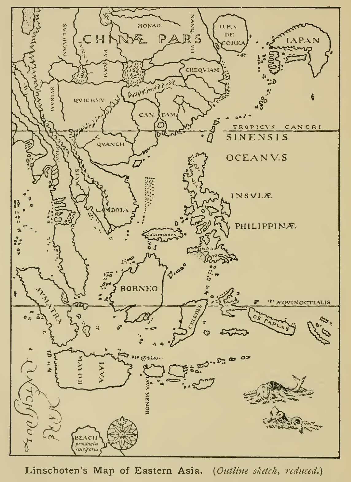
Linschoten's Map of Eastern Asia. (Outline sketch,
reduced.)
Click on the map to enlarge it.
Fleets now sailed in quick succession from the various Dutch ports, whose merchants vied with each other in their efforts to secure a share in the new trade. In 1598 a number of expeditions sailed under different commanders. The merchants of Amsterdam and Rotterdam despatched a fleet of eight ships under J. van Neck and W. van Warwijck, which reached Banda, Amboina, and the Moluccas, besides visiting Java. A part of the fleet, including van Warwijck's vessel, touched on the voyage at Mauritius, which then first received that name. No inhabitants were seen, but the island proved a convenient halting-place, and a garden was fenced in and planted for the benefit of future voyagers. The merchants of Middelburg and Veere, headed by the family of the Moucherons, fitted out two ships (the Lion and Lioness), which they placed under the command of the brothers Cornelis and Frederik Houtman. This expedition is of interest from the fact that the great Arctic navigator, John Davis, was engaged to act as chief pilot, and the account of the voyage written by him is the only one extant. Ill-luck attended the expedition, which reached Atjeh in Sumatra after touching at Fernando Noronha, Table Bay (then called Saldanha Bay), Madagascar, the Comoros, Maldivhs, and the coast of India near Cochin. Davis's narrative contains interesting particulars respecting the countries visited, mentioning among other points the peculiar clicking sounds of the Hottentot language, which are likened to the clucking of a brood-hen. It appears that the fame of Queen Elizabeth as the successful rival of Spain had already reached the East, and the Raja of Atjeh was particularly anxious to see Davis and to learn about the English nation, but the Dutch commander did all he could to keep him in the background. During the stay there a treacherous attack was made upon the expedition, during which Cornelis Houtman was killed and the ship only saved by the gallantry of Davis and two comrades, one of them an Englishman named Tomkins, who successfully defended the poop.[1] After a vain attempt to make the port of Tennasserim, which Davis speaks of as a place of much trade, a course was shaped for the Nicobars and the homeward voyage soon afterwards commenced. In July 1600 Middelburg was reached and Davis returned to England, where his services were soon secured by the English East India Company for their first voyage.
[1 There appears to be no foundation for the story that the elder Houtman escaped with his life and lived some years among the natives.]
During the year 1598 various Dutch ships were also sent out to attempt the passage to India viâ the Strait of Magellan. On June 27 a fleet of five ships set sail from Rotterdam under the command of Admiral James Mahu. Several Englishmen accompanied the fleet—among them the pilot, William Adams. From the outset the expedition was unfortunate, for soon after leaving the Cape Verde Islands the Admiral died of fever, by which a large proportion of the crews were disabled, while scurvy soon added to their distress. A landing was effected on the coast of Lower Guinea and a camp formed for the sick; but few supplies were available and the fleet sailed for Annobom. Here the Dutch came into collision with the Portuguese and also suffered severely from fever, so it was resolved to steer for the Strait of Magellan. Here the ships encountered very severe weather and, after reaching the Pacific, soon became scattered. Two were forced to re-enter the straits, and of these one eventually crossed the Pacific to the Moluccas, where she fell into the hands of the Portuguese. The other, under Sebald de Weert, fell in with the outward-bound fleet of Olivier van Noort, but returned home after visiting some small islands, probably outliers of the Falklands. A single unsupported document has it that a third ship—that commanded by Dirck Gerritsz—was driven south to 64°, where a snow-clad mountainous land was sighted; and on this insufficient basis some have claimed for her commander the discovery of the South Shetlands. This ship was taken by the Spaniards after reaching Peru.
Meanwhile the rest of the fleet, under the command of Simon de Cordes, and with the English pilot, William Adams, on board, proceeded up the coast of Chile. No full account of the voyage is in existence, but we are able to gather some details as to its occurrences from the letters of Adams, written some years later from Japan, and from the facts gleaned by Van Noort's squadron. Misfortune still attended the voyagers. Landing at the island of La Mocha, de Cordes and a number of his men were slain by the natives,[1] while the same fate befel the other captain and a portion of his crew at Punta de Lavapie, opposite Santa Maria Island. Not venturing to meet the Spaniards in their weakened condition, and having on board a large supply of woollen cloth which they hoped to dispose of in Japan, the newly elected captains resolved to steer for that country (November 1599). After crossing the Line some islands were met with, inhabited by cannibals. They are placed by Adams in 16° N., or three degrees south of the Sandwich group, which might otherwise seem to be indicated. They were no doubt units of the Ladrone or Marianne group, though in this case the length of time occupied by the further voyage to Japan—almost equal to that taken up by the voyage from Chile to the islands—is only to be accounted for by the storms encountered in the Western Pacific. These led to a parting of the ships, and only that in which Adams sailed reached Bungo (the modern Oita) in Japan, the crew being then at the last extremity. Adams was imprisoned for a time, but afterwards rose high in the Emperor's favour, and was largely instrumental in throwing open the trade with Japan to the Dutch. He was never allowed to return to Europe, but died at Firando (Hirado Island) about 1620.
[1 In the account given to Van Noort it was said that Simon de Cordes was slain at the Punta de Lavapie, but Adams gives Mocha Island as the scene of his death.]
The four ships of Van Noort already alluded to sailed from Goeree only three months after the Rotterdam fleet (September 1598). Like the latter they touched at the coast of Lower Guinea and then twice visited the coast of Brazil before proceeding to the Strait of Magellan. Arrived in the South Sea, Van Noort was attended with better success than his predecessors, taking a Spanish ship on the coast of Chile, and then crossing over to the Ladrones and Philippines by a route apparently diverging little from Magellan's. Off the Philippines a Spanish ship was defeated after a hot encounter, and a course was then shaped for Borneo, where a halt was made at Brunei. Van Noort then proceeded to the north coast of Java, and passing through the strait between that island and Sumatra, steered for the Cape of Good Hope. He arrived in Holland with one ship on August 26, 1601, being thus the first Dutch captain to complete the circumnavigation of the globe—a feat which it had taken full three years, to accomplish. Although Van Noort had not passed out of the tracks of previous navigators, his voyage was of service to his countrymen, as much information was collected about countries of the East, including Japan, not visited by his squadron.
The subsequent trading voyages of the Dutch to the East, while of importance as tending to establish the supremacy of that nation in the Archipelago, and so paving the way for the discovery of Australia, lack the interest of novelty which attaches to their earlier efforts. In pursuance of their object the merchant adventurers showed no abatement of energy. Trading companies had been formed at the various Dutch ports, whence fleet after fleet was despatched to the East. In 1602 the various companies were united to form the Dutch East India Company, with an exclusive charter prohibiting other Dutch subjects from trading to the East, either by the Cape or by the Strait of Magellan. The company's fleets engaged in open hostilities with the Portuguese, while trading stations were rapidly established in Java and Ceylon, as well as on the Malabar and Coromandel coasts. By 1607 the Dutch had gained possession of the Spice Islands and had factories in all the countries of the East from Persia to Japan. In 1611 Pieter Both, the first Governor-General, established a post at Jacatra in Java, some distance east of Bantam, giving it the name Batavia; and in 1619 the Residence was transferred by the fourth governor, Jans Pieterszoon Coen, to this site, which thenceforth became the capital of the Dutch possessions. Some of the voyages thus undertaken were of interest from the point of view of geographical discovery, but before speaking of them we must resume the thread of English adventure.
In spite of the ill-success of the first English voyage to the East, the wish to establish a direct trade with India still animated the English merchants, but nothing was done until 1599 when, the Dutch having raised the price of pepper from 3s. to 6s. and 8s. a pound, a memorial was addressed to Queen Elizabeth on the subject of the formation of an association for the object in view. The Queen favoured the proposal, and on December 31, 1600, granted a charter of incorporation to the English East India Company as "The Governor and Company of Merchants of London trading into the East Indies." She also sent Sir J. Mildenhall to the court of the Great Mogul to solicit his favour for the company. Before the signing of the charter preparations for an expedition had been pushed forward, Captain James Lancaster being again placed at its head. Four "tall" ships—the Dragon, Hector, Ascension, and Susan, besides a victualler, the Guest—were employed. As before mentioned, the services of John Davis were secured for the expedition, which left Woolwich on February 13, and Tor Bay on April 18, 1601. After touching at the Canaries and suffering much from scurvy and from adverse winds during the passage across the Atlantic, it put in at Saldanha Bay (Table Bay) on September 9. The great use of lemon-juice as a preventive of scurvy was fully demonstrated on this voyage, as the crew of Lancaster's ship, who were provided with it, suffered far less than those of the others. After a stay at Table Bay, and another on the coast of Madagascar, the ships set sail for India on March 6, 1602, and fell in with an island called Roquepiz, the identification of which is a matter of some difficulty. Then, after passing amongst the Chagos Islands and banks, where the ships were in much danger from sunken reefs, the Nicobar Islands were reached on May 9, and Atjeh on May 29. A letter from the Queen was presented to the King of Atjeh, who gave the voyagers a cordial reception. Some pepper was obtained, but owing to the bad season it was very scarce. More, however, was obtained at Priaman, and at Bantam, whither the ships afterwards proceeded, having first taken a merchant ship, sailing under Portuguese colours, in the straits of Malacca. Agents were left at Bantam and others despatched to the Moluccas, to establish a factory there in readiness for the next arrival of ships from England. On February 20, 1603, the homeward voyage commenced, the ships passing through the Sunda Strait. Before rounding the Cape great storms were encountered, in which the rudder of Lancaster's ship was lost, and the voyagers were driven southwards into the hail and snow of the South Atlantic; but after great exertions a temporary rudder was arranged, and St Helena sighted on June 16, the ships having been three months out of sight of land. Finally they anchored in the Downs on September 11, and the voyage was brought to a successful termination, two and a half years from its commencement.
The second expedition was placed under the command of Captain Henry Middleton, who had accompanied Lancaster in 1601, and the same four ships were again sent out. Again the crews suffered severely from scurvy, and on this account the General put in, contrary to his instructions, at Table Bay, afterwards crossing the Indian Ocean without touching anywhere until the island of Engano, off the south coast of Sumatra, was sighted. From Bantam, where the merchants left on the preceding voyage were established, the Hector and Susan were sent home after loading with a cargo of pepper, while Middleton proceeded (Jan. 1605) with the other two ships to the more eastern parts of the Archipelago. During this time great mortality prevailed among the crews owing to an outbreak of dysentery brought on by drinking the Bantam water. A large Dutch fleet under Van der Hagen had arrived at Bantam two days before the English, and it soon followed them on their eastward voyage. At Amboina, where, owing to the peace lately concluded (1604) between England and Spain, Middleton had established friendly relations with the Portuguese governor, all hope of trade was removed by the arrival of this fleet and the surrender of the Portuguese fort. Middleton therefore resolved, much against the views of his associates, to send the Ascension to Banda, while he himself proceeded to the Moluccas proper, to try for a cargo of cloves. Here too the arrival of the Dutch, followed by the destruction of the Portuguese fort at Tidor, and the surrender of the survivors of its garrison, put many difficulties in his way, but a certain amount of trade was done, and in spite of some rather high-handed proceedings on the part of the Dutch, the English commander was able to remain on fairly friendly terms with both factions. On the return voyage the Hector was found in a disabled condition off the Cape, having lost the greater part of her crew, which it had been necessary to reinforce with a number of Chinamen before leaving Bantam. The Susan had been lost during the passage. The three remaining ships continued the voyage in company, and reached the Downs on May 6, 1606.
By opening a trade with the Moluccas, which had not been visited by Englishmen since Drake's time, Middleton had done more than the company had ventured to expect, and he was knighted for his services immediately on his return. The company now determined to extend their operations, and turned their eyes to the mainland of India, whither one of the ships of the next voyage was commissioned to proceed. The three vessels sent out in 1607 were under the command of Captain Keeling, who had accompanied Sir Henry Middleton in 1604. In the new voyage he sailed in the Dragon, while the Hector and Consent were commanded respectively by Captains Hawkins and David Middleton, the latter of whom, as it turned out, made the voyage independently. The course taken by the Dragon and Hector differed from that followed in previous voyages, for they put in at Sierra Leone for the purpose of watering, and here a stone was set up, engraved with the names of Captains Keeling and Hawkins, near another which bore the names of Drake and Cavendish. After refreshing at Saldanha, and again touching at St Augustine's Bay, Madagascar, they proceeded to Abd-el-Kuri and Sokotra, where valuable information was collected as to the system of the monsoons and currents, and the navigation to Aden, Surat, and Cambay. After leaving Sokotra, the ships parted company, the Hector proceeding to Surat, whence Hawkins sent his ship on to Bantam, and travelled overland to the court of Jehangir; his journey resulting in the acquisition of information, of much value to the company, regarding the state of affairs in India. Keeling proceeded to Priaman and Bantam, and afterwards to Banda; some useful hydrographical observations being made during the voyage. Trade was again hampered by the arbitrary proceedings of the Dutch, who were then at war with the natives. Since Middleton's voyage they had been driven out of Ternate and Tidor (1606), and their admiral, Paul van Caerden, was in 1608 taken prisoner there, remaining in captivity over a year.
The fourth voyage, under Captains Sharpeigh and Rowles, was unfortunate. After visiting Aden, and Mokha on the Red Sea, Sharpeigh proceeded to India, where his ship was wrecked in the Gulf of Cambay. Sharpeigh visited Agra, while others of his crew travelled in various directions, a sailor named Nichols making his way across the peninsula to Masulipatam, while Captain Robert Coverte returned to Europe through India, Persia, and Turkey. The latter wrote an account both of the voyage and of his own travels. The fifth voyage sent out by the East India Company was under the command of Captain David Middleton, who in 1610 obtained a cargo of spice at Pulo Way, being, like Keeling, hindered by the Dutch from loading at Banda. In the sixth voyage Sir Henry Middleton was general, the second in command being Captain Nicholas Downton. The ships proceeded to Aden, which was found to have lost much of its former importance, and to Mokha, where Middleton was made a prisoner, and taken inland to Sanâ. Having at length effected his escape, he sailed for Surat, where many impediments were put in his way by the Portuguese. Subsequently reaching the Archipelago, his ship, the Trade's Increase, the largest English merchant vessel of the time, capsized while being repaired, and Middleton soon afterwards died of grief at the partial failure of the voyage. It was, however, important as leading the way to the English intercourse with Western India, which subsequently attained such great proportions.
Of the subsequent voyages only those can be spoken of which were especially noteworthy as leading in new directions. During the seventh, which sailed in 1611 under Captain Hippon, the Globe visited the Coromandel coast and Siam, where factories were established both at Patani—then an important trade centre—and at Ayuthia, the capital. Two of the factors were even sent inland to Chieng-mai or Zimmé, which had been visited in the previous century by Fernão Mendez Pinto and by Ralph Fitch, and which has come into prominence in modern times in connection with railway projects in Siam. One of these agents, Thomas Samuel, was a year or two later (1615) taken prisoner to Pegu on the capture of Chieng-mai by the king of that country, and died there.
The eighth voyage (1611-13), under Captain John Saris in the Clove, was important as leading further afield than any of the previous ventures, Japan being for the first time reached by an English vessel. After visiting Sokotra and cruising for some time in the Red Sea, where Saris met Sir Henry Middleton, the Clove sailed for Bantam, and thence for the Moluccas, where, after touching at various points, anchor was finally cast in the road of Pelebere (or Poliweri) off Makian. Here, as usual, some opposition was met with from the Dutch, who at the time had forts on Ternate, Tidor, and Makian, though the Spaniards still maintained a footing in Tidor. Continuing his voyage towards the north, and touching to refresh on the northern portion of Jilolo, Saris set sail for Japan, and passing among the Liu-kiu Islands, reached Firando (Hirado) after a month's voyage. Here Saris received a visit from William Adams, and leaving Richard Cocks, the principal merchant of the voyage, to establish a factory, proceeded viâ Osaka and the overland route to Yedo (Tokio) to hand over the presents sent by the Company to the Emperor. His journal gives interesting particulars respecting the Japanese cities, of which Kioto or Miako was then the largest. On Saris's departure Cocks was left at Firando to superintend the factory, which he did for seven years. During this time the establishment of trade between Japan and Siam was kept constantly in view, and Adams more than once sailed for the latter country, but the efforts of the merchants met with slight success. Saris's voyage resulted in a considerable improvement in the knowledge of the navigation of the Eastern seas, and his journal contains instructive remarks on the currents, monsoons, etc., as observed by him. He was able to introduce many corrections into the charts, his latitudes for Cape Comorin, the island of Batjan, and other places, being nearer the truth than those previously accepted. Between Sokotra and Bantam he sailed through the 8° channel between the Maldivhs and Minicoy, and was thus able to define correctly the termination of the Maldivh group towards the north, while Firando in Japan, the terminus of his voyage, is given within 8' of its true latitude.
The only other voyage to which separate allusion can be made is that of Captain Best, which was begun in 1612, and by the victory gained over an overwhelming Portuguese fleet at Swally, the port of Surat, opened up Western India to British enterprise. A result of this victory was the despatch of Sir Thomas Roe, in 1615, as ambassador to Jehangir. To his travels reference will be made presently. A few years later trade was opened with the Persian Gulf, but Bantam in Java still remained the Company's principal factory in the East, until, between 1618 and 1623, the British merchants were expelled from all their posts in the Archipelago by the Dutch, who thus became supreme in that quarter, and were for a long time practically alone in carrying on the work of exploration in the regions beyond.
It remains to speak of the attempts—insignificant compared with those of the Dutch and English—made by the French at this time to open up intercourse with the East. Although this nation was the first to encroach upon the grounds occupied by the Portuguese, the early enterprises of Gonneville, Parmentier, and others, in the first half of the sixteenth century, led to no practical result, and not till the next century had commenced did the French merchants again bestir themselves to secure a share in the eastern trade. A company was then formed by some citizens of St Malo, Laval, and Vitré, and two vessels were fitted out and placed under the command of Michel Frotet de la Bardelière, who sailed in the Croissant. The other ship, the Corbin, was commanded by François Grout, and an Englishman was included among the crew as pilot. The expedition sailed in 1601, but was unfortunate from the first owing to severe attacks of scurvy and want of discipline. The Croissant reached Atjeh in July 1602, but left again without doing much trade. The General died on December 1, and after reaching the Azores the enfeebled remnant of the crew were rescued from their sinking ship by some Dutch vessels. The voyage is principally remarkable for the adventures of François Pyrard, who sailed in the Corbin, and after his return wrote a full account of his experiences, together with valuable information on the countries visited. The Corbin was wrecked on one of the Maldivhs, and the crew made prisoners. Pyrard soon acquired the language and gained favour with the king, but had not obtained leave to depart when at length, after five years, a hostile expedition arrived from Chittagong. The king was slain, and Pyrard with three companions, the sole remnant of the crew, was taken to India. He gives a most valuable account of the Maldivhs, and of the manners and customs of the people; and so few have been European visitors to the islands that this remained practically the standard authority on the subject down to our own times.
Pyrard's stay at Chittagong was brief, but it enabled him to collect a few particulars respecting Bengal and its productions, the river Ganges, etc. On the Malabar coast, whither he then proceeded, he went through many adventures and was for some time kept a prisoner by the Portuguese. After his release he collected much information respecting Western India and its inhabitants, and particularly about Goa and the Portuguese government in India—then hopelessly corrupt—and the growing encroachments of the Dutch. His account is of special value from the fact that this period is little touched upon by Portuguese historians. He accompanied Portuguese expeditions to Cambay and the Moluccas, and gives a full account of the trade of south-eastern Asia, which still centred in the great emporium of Malacca; describing also the Portuguese possessions on the African coasts. At last, in the winter of 1609-10, Pyrard, with other foreigners, whose numbers had become inconvenient to the authorities, was placed on board the homeward-bound fleet, and reached Europe, not without further adventures, after an absence of ten years. The ship in which Pyrard sailed was wrecked on the coast of Brazil, and his sojourn at Bahia, whilst waiting for an opportunity to return to Europe, gave him the means of gathering some information on the Portuguese possessions in that part of the globe.
Two other French travellers, mentioned by Pyrard in his book, may be briefly referred to here. Jean Mocquet, apothecary to Henry IV of France, travelled extensively both in the East and West (West Africa, Guiana, Morocco, India, and the Holy Land) between 1601 and 1611—exactly the period occupied by Pyrard's voyage—and in 1617 published in Paris an account of his travels. He had sailed to Goa as apothecary to the Conde de Feira, and returned in that capacity, in the same fleet as Pyrard, with the great captain Furtado de Mendoça. The other traveller was the Sieur de Feynes, Comte de Montfart, who in 1604 had reached Goa by the overland route via Aleppo, Isfahan, and Ormuz. The first account of his journeys was published in English in 1615 by a French resident in London. Doubt has been thrown on the genuineness of his travels, but the references of Pyrard and Mocquet confirm the general truth of his account.
No further attempt to open up trade with the East was made until 1616, when some merchants of Paris and Rouen formed a company and fitted out two ships for a voyage to India. The command was given to a captain named De Nets, the smaller ship sailing under Augustin de Beaulieu, who had already in 1612 accompanied a French expedition to the Gambia, and had shown himself a skilful seaman. The expedition met with only partial success, one of the ships being abandoned for want of sufficient hands. In 1619 Beaulieu sailed again with three ships, and though the results from a commercial point of view were not great, the voyage has attained a considerable degree of celebrity by reason of the careful observations on the countries visited made by the commander, and contained in his journal, published in Thévenot's celebrated collection of voyages. The variation of the compass engaged the special attention of Beaulieu, who was able to show that the variations were less regular than had been supposed. An accurate description is given of the narwhal, two of which were seen on the voyage. Some time was spent at the Cape on the way out, and an interesting reconnaissance made of the district behind Table Mountain. The modern Table Bay already receives that name in Beaulieu's narrative, although the old name Saldanha Bay is retained by contemporary, and even by some subsequent writers. During a stay of 15 days at St Augustine's Bay, Madagascar, Beaulieu attempted an exploration of the valley of the river which enters the head of the bay; and though hindered by the thickness of the brushwood, he climbed to a certain height and assured himself of the importance of the river, which, he says, seemed as broad as the Seine a league below Rouen. This must have been the Onilahi, the principal river of south Madagascar. After correcting the position on the chart of the Angoche and other small islands on the African coast, Beaulieu sailed for the Comoro Islands, of which he gives a fuller account than is found in most of the early narratives. This is especially the case of Angasija, or Great Comoro, which on account of its want of good anchorages has down to the present day been less visited than the other islands of the group. Having at length reached Sumatra, a long time was spent at Atjeh in wearisome negotiations for a cargo of pepper. Bantam being inaccessible owing to its investment by the Dutch. One of the ships, which had proceeded to Jacatra (Batavia), was burnt, apparently through Dutch treachery, but Beaulieu at length set sail for France with a fair cargo, passing through the Mentawei ("Montabay") Islands off the south-west coast of Sumatra, and introducing some corrections into the charts of that locality. He reached France in December, 1622.
Before continuing the story of maritime discovery in the far East, we may close this chapter by referring to some of the most famous travellers to southern Asia—chiefly by the overland route—during the seventeenth century, although by so doing it will be necessary to anticipate somewhat the progress of events in other quarters. With the opening of maritime trade to the East by the rivals of the Portuguese, the love of adventure led a host of travellers—Dutch, French, English, and German, as well as some of nationalities previously represented—to visit the famous empires of those regions; and as many of them published narratives of their journeys, the result was a decided spread of knowledge respecting those countries, although strictly geographical discoveries could hardly be expected.
Of all the narratives of eastern travel which appeared during the seventeenth century, the first in point of date of the journeys was that of the French adventurer Vincent le Blanc, who during forty years ranged over most of the eastern world, from Syria, Arabia, and Samarkand, to Pegu, Siam, and Java, and in Africa gained acquaintance with Abyssinia, Egypt, and Morocco. But the greater part of his journeys were made before the end of the sixteenth century, while his narrative—first published, after his death, in 1648—shows much ignorance and want of discrimination, even if it be not—as some have thought—largely fictitious. A Portuguese traveller, Pedro Teixeira, whose wanderings were almost as extensive, published his narrative in 1610, but he too started on his travels before the end of the previous century. Of his first journey nothing is known except that after residing for some time in Persia and Ormuz, he found himself at Malacca in 1600, and returned to Portugal by way of the Archipelago (Sumatra, Borneo, the Philippines) and Mexico. He set out again in 1604, and after visiting Maskat and Ormuz returned by Baghdad to Aleppo, and thence through Cyprus, Rhodes, etc., to Venice, and ultimately to Antwerp. The desire of seeing foreign countries led an eccentric Englishman, Thomas Coryat, to the East a few years later. Coryat had held a small post in Prince Henry's establishment, but in 1608 started on a tour through Europe, which he described in a book bearing the quaint title Coryat his Crudities hastily gobled up etc. In spite of the eccentricities of the author, this was of some real value as one of the first detailed descriptions of European countries published in England. In 1612 Coryat started on more extended travels, which took him through Asia Minor, the Holy Land, and Mesopotamia, to Persia and even to Kandahar, whence he reached India in 1616. Here he died the following year, and therefore never wrote a narrative of these journeys, but some of his letters to friends from the East were published, the last being dated from Agra, October, 1616.
Disappointment in a love affair was the cause of the travels, about the same time, of an Italian, Pietro della Valle, who in 1614 left Venice on a pilgrimage to the holy places of the East, taking the title "Il Pellegrino" by which he was afterwards generally known. From Jerusalem he went by Damascus to Aleppo, and on to Baghdad and the ruins of Babylon. At Baghdad he married a beautiful Circassian, who accompanied him on his travels till her death, and whose body was embalmed and taken to Italy. Delia Valle made his way to the court of the Persian Emperor, and in 1621, after a visit to the ruins of Persepolis, reached Shiraz, and Lar on the Persian Gulf, whence he made his way to India. After extensive travels in that country he sailed for Maskat in 1624, and returned to Europe viâ Bassora and Aleppo. His voyages, the publication of which was completed at Rome after his death in 1652, contain many interesting particulars concerning the countries through which he passed.
The above were private adventurers, but others of the number held more or less official positions as envoys to the courts of Eastern monarchs. Such was Sir Thomas Roe, whose embassy to the court of the Great Mogul in the interests of British trade has already been referred to. Roe, who had previously made a voyage up the Amazon and on the coast of Guiana, was one of the most capable agents employed by the East India Company. He arrived at Swally Road in September, 1615, and after much obstruction on the part of the authorities, made his way to the court of Jehangir at Ajmere before the end of the year, passing through Burhanpur, where he suffered a severe attack of fever. He spent nearly three years in wearisome negociations with the Emperor and his ministers, and his journal, first published by Purchas, contains, besides the narrative of his journey, much valuable information as to the events then going forward in India. During Roe's residence in India, Edward Terry, an Oxford graduate—who had sailed in 1616 in one of the East India Company's fleets, and who, after his return to Europe, also wrote an account of his experiences—joined him as chaplain. Another of the Company's servants who travelled in India at this time was William Methold, who in 1622 visited the diamond mines of Golconda, and gave the first account of them ever published by an English writer.
Persia, too, was the goal of various embassies during the early part of the seventeenth century. In 1599 Sir Anthony Shirley, a relative by marriage of the Earl of Essex, had received from the latter an informal mission to that country, whither he proceeded with his brother Robert by the overland route viâ Aleppo so often followed at this time. Sir Anthony soon returned to Europe, where (having fallen into disfavour in England) he wandered from one court to another, sometimes well received but finally discredited.[1] Robert (afterwards Sir Robert) Shirley stayed longer in Persia, and subsequently undertook various embassies, on behalf of the Shah, to the countries of Europe, including Great Britain, where he was well received by James I. He returned to Persia for the last time in 1627 in company with the English agent Sir Dodmore Cotton, but was coldly received on his arrival at Kasvin, and died shortly afterwards. Cotton had another companion on his mission to Persia, whose account of his travels attained considerable celebrity. This was Sir Thomas Herbert, who after reaching Kasvin (where Cotton too died), made extensive journeys in Persia, afterwards visiting India and Ceylon, whence he returned to Europe in 1627, by Mauritius and St Helena. His narrative contains many curious observations on the countries visited, and the objects of interest observed. Among the latter was the dodo, Herbert's quaint account of which is one of the earliest we possess.
[1 The Emperor Rudolf II, by whom he was well received at Prague, despatched him in 1605 on a mission to the court of Morocco, an account of which appeared in 1609.]
The next embassy to Persia which need detain us was that sent through Russia by the Duke of Holstein in 1633, with a view to opening up a trade with the East for his subjects. The secretary to the ambassadors was the celebrated Adam Olearius, while another of the party was J.A. de Mandelslo, an intimate friend of the former and previously page to the Duke. The ambassadors proceeded no further than Persia, but Mandelslo, who had obtained leave to go on to India, embarked at Ormuz in 1638, and landing at Surat, travelled first to Agra, and afterwards made the voyage to Goa and Ceylon, returning to Europe by the Cape. The account of his journeys was published after his death (1644), from his letters, by Olearius, as a supplement to the latter's own description of Russia and Persia. It contained information collected by Mandelslo respecting countries of the East not visited by him personally, and in a subsequent edition was enlarged by the addition of extraneous matter. Both Olearius and Mandelslo were men of education, and made astronomical observations during their journeys. In the second half of the century a Russian embassy to Persia was accompanied by a Spaniard, Don Pedro Cubero, who likewise visited India but returned to Europe by the Philippines and Mexico, publishing an account of his nine years' travels at Madrid in 1680. The Swedish embassy to the same country in 1683, under Louis Fabricius, may also be mentioned here. It is noteworthy through the part taken in it by the celebrated traveller Engelbrecht Kaempfer, a German physician and naturalist, who after crossing Persia to Gombrun joined a Dutch fleet as surgeon (1688), visited north and south India and Batavia, and thence went to Japan, where he remained three years, collecting valuable material for an account of that country. After his return to Europe in 1693 he published an account of his travels under the title Amoenitates Exoticae, which appeared in 1712. His history of Japan, the best known of his works, was published, after his death, from his MSS.
The work of missionary travellers to the far East will be spoken of in another chapter, but the journeys of one of their number, as concerned also with western Asia, may be suitably touched upon here. Père Alexandre de Rhodes, a French Jesuit, started for the Indies in 1618, and a few years later was sent to labour in Cochin China. Here and in Tongking he maintained an uphill fight for many years against difficulties and persecutions, until finally obliged to abandon the country. After visiting the Archipelago he returned to Europe through Persia, Armenia, and Asia Minor, returning in 1660 to Persia, where he died. He published an account of his travels in 1653.
As time went on, travellers to the East became more and more numerous, and only the most famous can be briefly mentioned. Jean Baptiste Tavernier, the son of a Dutch map-seller settled in Paris, began his extensive travels by visiting most of the countries of Europe, and in 1631 joined a caravan to Persia, where his trading ventures met with such success that he devoted himself for the future to eastern commerce, buying diamonds and other precious stones to dispose of in Europe. After various journeys he fell ill on the Volga and died at Moscow in 1689. His Voyages, published in Paris in 1677-79, are a valuable authority on the trade and trade-routes of the East at the time, and especially on the diamond and other mines of India. Another famous French traveller, François Bernier, started for the East in 1654, and after visiting Syria and Egypt made his way to India, where he resided some years as physician to Aurungzeb. His accounts of the political affairs of the Mogul empire, first published in 1670-71, give a valuable insight into the events of the time, while his description of Kashmir, which he visited himself, is the earliest, in any detail, that we possess.
Jean de Thévenot, nephew of the celebrated collector of travels, Melchisedek Thévenot (himself, too, a traveller of some note), made two extensive tours in the East, and died at Tauris in 1667 on his final return from India through Persia. His travels were afterwards published at Paris in 1684. Sir John Chardin, who, like Tavernier, was interested in the diamond trade, was the son of a Paris jeweller. During two separate visits to the East, he resided many years in Persia, and paid some attention to its antiquities and history. He was knighted by Charles II during a residence in London, where he commenced the publication of his memoirs in 1686. The list may be closed with the name of Dr John Fryer, a Cambridge graduate, who between 1672 and 1682 travelled through India and Persia in the interests of the East India Company, and wrote a New account of East India and Persia (1698), one of the most readable descriptions of India in the seventeenth century that we have.
A word or two must be devoted in conclusion to European travellers in Further India during this period. The establishment of English trade in Siam has already been spoken of. The Dutch too devoted some attention to that country as well as to the neighbouring kingdom of Cambodia, and their agents are said even to have made journeys into the Laos countries on the Mekong. After the early attempts of Père de Rhodes to found a mission in Cochin China, these regions were the scene of much missionary enterprise on the part of the French Jesuits. Between 1660 and 1662, three bishops in turn set out for Siam and the first and third of these, Mgr de la Mothe, bishop of Beirut, and Mgr Pallu, bishop of Persepolis, reached their destination in safety, taking the overland route to the Persian Gulf, crossing India to Masulipatam, and the Malay Peninsula near Tenasserim. The overland passage from the Bay of Bengal to Siam viâ Tenasserim, though involving many difficulties, was often used at the time—among others by the servants of the East India Company. It led up the Tenasserim river to Jelunga, whence it crossed the watershed and debouched near the north-west corner of the Gulf of Siam. An account of the journey of Mgr de la Mothe was written by his companion M. de Bourges in 1666 while Pallu, who after returning to France went out again in 1670-73, published an account of his own journeys in 1682. Other missionaries soon made their way to Siam, but French intercourse with the country was not kept up only by these, for various embassies were about this time exchanged between Louis XIV and the king of Siam. The first French mission was headed (1685) by the Chevalier de Chaumont, in whose company various ecclesiastics sailed, including the Jesuit Tachard, and five others of his order destined for China. Two accounts of the embassy were written, one by the Jesuit just mentioned. In 1687-88 another French embassy reached Siam under M. de la Loubère, whose account of the country, published in 1691, is the best that has come down to us from this period. M. Tachard made the voyage a second time with La Loubère, and again published an account of his experiences. After this second embassy, French interest in the affairs of Siam seems to have declined.
For the neighbouring countries on the east coast of Further India the various missionary reports, beginning with those of Pere de Rhodes, contain the best contemporary information. Many of the later accounts of the Jesuits were included in the Lettres Édifiantes et Curieuses of Legobien and Du Halde.
{Page 69}
We have reserved for a separate chapter the continuation of our narrative of Dutch voyages to the East, from the importance which attaches to them as finally setting at rest the question of the existence of a continental land to the south-east of Asia—the last great question of the kind to attain solution if we except the Antarctic problem, still but partially solved in our own day. The rapidly-narrowing limits of the unknown gave, in fact, little room for uncertainty as to the broad distribution of land and water on the globe, except just in the quarter where Australia was soon to be disclosed in its main outlines. We have already referred to the general belief in the existence of a Southern Continent, to which the discovery of the Strait of Magellan—apparently separating South America from another land-mass to the south—seemed to give confirmation, and which led all navigators who lighted upon new lands to the south to connect their discoveries with the same mysterious land. The old notion that Java formed the northern extremity of this supposed continent had not completely died out at the close of the sixteenth century,[1] in spite of the fact that Del Cano, Drake, and Cavendish had all passed to the southward of the island. As we have seen, the first Dutch Eastern voyage, under Houtman in 1595-96, finally set this doubt at rest as regarded Java, but it was not until many years later that the insular character of New Guinea was fully recognised, although the existence of a strait separating it from a larger land to the south had been surmised if not actually proved before the sixteenth century closed, as is seen from maps of Mercator, Hondius, Wytfliet and others. When therefore the Dutch applied themselves to southern discovery soon after their arrival in the East, a practically untouched field lay before them in the direction of Australia, for even conceding the possibility that its coasts had been sighted during the early part of the sixteenth century—and of this no satisfactory proof exists—there is no doubt that geographers generally, and those of Holland in particular, were totally ignorant of any such discovery at the end of the same century.
[1 Thus Linschoten, whose great work was published in 1595-6, still expressed a doubt as to the insular character of Java.]
The point to which attention was first directed was New Guinea. On the despatch of a vessel, the Duifken or "Little Dove", in 1602 for the purpose of opening up trade with Ceram, the Dutch authorities in Banda had already in mind the acquisition of fuller knowledge respecting "Nova Guinea", and although little was then accomplished, more success attended the voyage of the Duifken in 1605.[1] The vessel, commanded by Willem Janszoon of Amsterdam, sailed from Bantam on November 28 of that year, bound for the eastern parts of the Archipelago. After touching at the Ke and Aru groups the Duifken appears to have reached the coast of New Guinea in Lat. 5° S. and to have followed the shores round Prince Frederick Henry Island as far as the beginning of Torres Strait. Then steering south the Dutch vessel traced the eastern shores of the Gulf of Carpentaria, as far as 13° 45' S., having thus—for the first time so far as record exists—sighted the coasts of Australia. The true nature of Torres Strait—owing no doubt to the islands with which it is strewn—was not recognised, but the whole of the land seen was supposed to form part of New Guinea. The greater part was uninhabited, but on one or more occasions natives were seen, who are described as wild and black savages. Nine of the crew were murdered by them while attempting to open up trade. The farthest point reached was named Cape Keerweer ("Turn-again"), while—as we learn from a map of Janssonius first published in 1633, which embodies the results of the voyage—other names were given to points touched at, Prince Frederick Henry Island and the opposite coast being laid down respectively as Tyuri and Modder Eylandt. Some doubt has been thrown on the statement that the Duifken reached the latitude mentioned, and the attempt has been made to prove that the ship did not even reach the entrance to Torres Strait. This is due to the fact that subsequent explorers placed a "Cape Keerweer" in the vicinity of Prince Frederick Henry Island; but as the instructions to Tasman make mention of a chart by the officers of the Duifken showing the Cape in 13° 45' S., while we learn from the journal of a subsequent voyage (that of Carstenszoon in 1623) that the Duifken had at least been in 11° 48' S., the objection has little weight.
[1 The instructions to Tasman for his voyage of 1644, which constitute one of the principal sources of information for previous Dutch voyages to New Guinea and Australia, have been called in to support the opinion that the Duifken sailed on this voyage in 1606. But from entries in Captain Saris's journal, published by Purchas, there is no doubt that 1605 was the year. Saris, using the old style, gives the date November 18.]
The Duifken was back in Banda, as we learn from Saris, before June 15, 1606, and the priority of discovery thus undoubtedly belongs to the Dutch as compared with the Spaniards under Torres, who, as we shall shortly see, was still in the New Hebrides towards the end of June of the same year. It has been supposed, but on hardly sufficient evidence, that a second voyage to New Guinea was made by the Duifken in 1606-7.
We must now turn to the Spanish Expedition, which left Callao in Peru on December 21, 1605, under Pedro Fernandez de Quiros, and formed, it may be said, the closing episode of the great epoch of Spanish maritime discovery.[1] The expedition consisted of two ships and a launch, the second ship being commanded by Luis Vaez de Torres. Quiros had accompanied Alvaro de Mendaña as pilot on his second expedition of 1595, during which, in the search for the Solomon Islands, the Santa Cruz group had been reached. On this voyage his imagination had been fired by the idea of the great southern continent, which he imagined to lie in the neighbourhood of Santa Cruz, and which he thought would offer a magnificent field for colonisation. This idea took so much hold of Quiros that he devoted the rest of his life, though without success, to the task of discovering this land. Among his associates Quiros was regarded more or less as a visionary, and was besides unpopular as a Portuguese, a fact which must have greatly stood in the way of success.
[1 Although in the service of Spain, Quiros, like Magellan, was a Portuguese by birth. His native place is said to have been Evora.]
The object of the expedition of 1605-6 was the colonisation of Santa Cruz as well as the search for the great southern land. By the help of the various accounts which have come down to us [2]—which are in many ways fuller than those of other early Pacific voyages—we are able to trace with some precision the course followed, which brought the voyagers in view of many more islands than had been seen in most previous voyages. For 800 leagues Quiros steered S.W. by W., but on reaching the latitude of 26° began, contrary to the advice of Torres, to reduce his latitude, and thus appears to have passed through the centre of the Low Archipelago. The islets seen were for the most part uninhabited, and afforded no anchorage. On February 10, however, in about 18° 10' S., a "flat island with a point to the south-east full of palm trees" was found to be inhabited, and the people proved friendly, though timid. Two days later the ships ran along an island described by De Leza as sunk in the middle like a piece of sea surrounded by land. It was 25 leagues long and six broad, and lay in 16° 30' S. This latitude is that of the typical atoll Fakarava, with which the description is in striking agreement, though from the length assigned to it it is possible that other atolls running in the same general direction were included in the estimate.[3] Still making northing, the ships reached Lat. 10° 45', and for more than a month the direction varied little from west, the ships passing north of Samoa and the Fiji group. The crew of Quiros's vessel were now inclined to mutiny, and the failure to take prompt measures seems to have ultimately led to the partial failure of the enterprise. Another inhabited island was passed, and in the endeavour to obtain a much needed water-supply some slight collisions occurred. At length the high island of Taumaku, 60 leagues short of Santa Cruz, was reached, and after friendly dealings with the natives a more southerly course was steered, which led past the northern outliers of the New Hebrides to the largest island of the group, traversed by lofty chains of mountains, which received the name of Espiritu Santo. The ships anchored in the bay on the northern coast, which was named after St Philip and St James. Quiros appears to have made plans for the establishment of a settlement, which was to be called New Jerusalem; but being forced during a squall to run out of the bay, and the weather not suffering him to return, he after a few days steered north, and when in the latitude of Guam shaped a course for Acapulco, which was reached on November 23, 1606.
[2 These include, besides the memoirs of Quiros himself, narratives by Torres, by the pilot De Leza, and by the accountant Juan de Iturbe, with some other contemporary documents. The voyage is also described by Torquemada in his Monarquia Indiana.]
[3 The first inhabited island has been identified, by the late Admiral Sir W.J. Wharton, with the atoll of Anaa (or Chain Island), in which case the atoll sighted on February 12 would be one of those to the N.W. of Fakarava.]
This proceeding of Quiros in abandoning the enterprise without a more serious attempt to communicate with his second in command has been much criticised, and the reasons for such a course are by no means obvious. One explanation is found in a letter of Don Diego de Prado, who accompanied Torres on his further voyage and who states that Quiros had virtually been carried a prisoner to Mexico by a mutinous crew. No such reason is given by either De Leza or Juan de Iturbe, which would be intelligible enough if, as is possible, these were inculpated in the mutiny. Quiros returned to Spain and urged on the government, but without success, the desirability of further efforts for the discovery of the southern lands, which he variously names Austr(i)alia del Espiritu Santo, Indias Australes, or by analogous terms. Setting out in 1614 to make a last attempt, independently of government aid, he died without proceeding further than Panama.
Through the return of Quiros from Espiritu Santo it came about that the most important discoveries of the voyage fell to the share of Torres, whose subsequent achievements entitle him to a high place among the navigators of the seventeenth century. They are clearly described in the letter addressed by him from Manila to the Spanish king on July 12, 1607. The separation of the ships occurred on June 11, 1606, after which date Torres waited 15 days in the bay of St Philip and St James, in the expectation of Quiros's return. It was then decided to proceed without the flag-ship, and the island of Espiritu was coasted for some distance, although the strong currents prevented its circumnavigation. Having sailed on a south-west course for a considerable distance without sign of land, Torres turned N.N.W. and fell in with land in 11° 30', which he took for the beginning of New Guinea. In reality it would seem to have been one of the islands of the Louisiade group, possibly Tagula or Sudest.[1] For, from a legend on Don Diego de Prado's chart of the lands about China Strait (named by him Tierra de la Buenaventura) we learn that this strait—at the extreme east of New Guinea—was reached on July 18, after vain endeavours to approach the land during the preceding five days by reason of the dangerous reefs. This shows that land had been previously sighted, as is also indicated by the latitude of the first landfall, and the name applied to the whole country, this being derived from a festival falling on July 14. The further course is somewhat uncertain, as the distances given are exaggerated and the latitudes do not always fit in with any possible course. Torres seems to have sailed along the Louisiade reef and the south coast of New Guinea (where the first navigators to follow him were Bougainville and Cook), as far as 9° S., where shoals compelled him to resume a south-west course as far as 11° S.[2] Here large islands were seen, which must have been in the neighbourhood of Cape York Peninsula—itself possibly sighted. After two months' coasting of the shoal, the latitude of 5° S. was reached, and here the coast trended north-east and could not be followed on account of shoal water. Apart from the latitude this point would agree well with False Cape, the south-west point of Prince Frederick Henry Island, the shoal water recalling the Modder (Mud) Eylandt and Modder Grondt of Dutch navigators in this locality. A northerly course brought the voyagers to another coast running east and west in 4°, which was rightly considered to be still a part of New Guinea. It was followed to the W.N.W., and near its termination clothed "Moors" were met with, who gave information regarding affairs at the Moluccas. Leaving New Guinea and passing through a sea strewn with islands, Torres reached Batjan and proceeded viâ Ternate to Manila, where he seems to have arrived in May, 1607.
[1 Torres uses an ambiguous phrase with regard to the distance sailed on a south-west course, saying that he passed "the latitude" by a degree. He had already spoken of "the order" for the regulation of the voyage, so that the phrase would seem to refer to the latitude fixed upon to be reached towards the south after leaving Santa Cruz. From Quiros's memoirs we know that this was 20°, so that, passing this by a degree, Torres would reach 21°, which is in fact stated to have been the case in the memorial of Arias. A S.W. course to this latitude, followed by a N.N.W. one, would just bring the navigator to Sudest Island.]
[2 Torres's latitudes have caused commentators some difficulty here. He says the shoal which commenced at 9° S. stretched along the coast until 7° 30' S., and "the extremity is 5" [degrees?], whereas the head of the Gulf of Papua is hardly so far north as 7° 30'. The difficulty is removed if we consider that 5° gives the latitude of the final termination of shoal water north of the Aru Islands, and this fits in well with the subsequent statement, that after going along the shoal for two months the voyagers (after the passage of Torres Strait) found themselves in 25 fathoms and in 5° latitude. In this case it would be possible that the head of the Gulf of Papua was not reached.]
By this voyage Torres had conclusively proved the insular character of New Guinea, of the southern portions of which he had taken formal possession in the name of the King of Spain. In the state of decadence into which that empire had now entered, these important discoveries were, however, little heeded, and the world at large remained in total ignorance of them for nearly two centuries. The Dutch still believed in a connection between New Guinea and Australia, or at least regarded the question as still open, even their great navigator Tasman remaining in ignorance on the subject. It was not until the narrative of Torres had fallen into the hands of Alexander Dalrymple after the capture of Manila by the English in 1762, that full justice was done to the merits of Torres, and his name applied to the strait discovered by him.[1]
[1 A map, now lost, showing the results of Torres's discoveries, was prepared by Don Diego de Prado, already alluded to. Plans by the same hand of bays and harbours on the coasts visited have, however, come down to us, and are generally accurate in their delineation. They were first reproduced in the Boletin of the Madrid Geographical Society, Vol. 4, 1878, and subsequently in Collingridge's Discovery of Australia, chapter XLI, and elsewhere.]
Another Pacific voyage, of some importance in the history of discovery, was that of the Dutch navigators Willem Corneliszoon Schouten and Jacob Le Maire, which belongs to the second decade of the seventeenth century. This expedition, which sailed from the Texel on June 14, 1615, was not carried out under the auspices of the Dutch East India Company, although the latter had obtained the monopoly of all trading voyages to the east of the Cape, or through the Strait of Magellan. To elude the restrictions thus imposed on outsiders, a company of merchants headed by Isaac Le Maire (father of Jacob) fitted out two ships, the Eendracht and Hoorn, to search for a passage to the South Sea south of Magellan's Strait. It was regarded as possible that rich countries, with which trade might be opened up, might be found in the supposed Southern Continent beyond Tierra del Fuego. The insular character of the latter had already been virtually proved by the voyages of Drake and others, which had in fact much shaken the grounds for the belief in any continental land immediately to the south of America.[1] The conservatism of geographers, however, had refused to abandon the old idea. On January 24, 1616, the Dutch captains sighted the passage between Tierra del Fuego and the smaller island to the east, and conferred on it the name Le Maire Strait. To the island—not recognised as such at the time—the name Staten Land was given, in honour of the States General of the Netherlands. On January 29, the ships were off Cape Horn, the southernmost point of the Tierra del Fuego archipelago, which received its name from the town of Hoorn, the birthplace of Schouten, and the port where the expedition had been equipped.[2] Soon afterwards the voyagers had before them the wide waters of the South Sea.
[1 So early as 1525, one of the ships of the squadron of Garcia de Loaysa had found an open sea in latitude 55°, and the crew even imagined they discerned the termination of Tierra del Fuego.]
[2 It is possible that Drake had already seen Cape Horn, as he is said by his chronicler to have reached "the uttermost part of those islands."]
Before continuing the narrative of Schouten's voyage, the later explorations in this region may be briefly referred to. In 1618-19 an expedition to examine Le Maire Strait was undertaken by the brothers Bartolomé Garcia and Gonçalo de Nodal, who sailed from Lisbon for the purpose. The strait was also navigated by the Dutch "Nassau" fleet under Jaques l'Heremite (or le Hermite) in 1624. On this occasion, after doubling Cape Horn, the Dutch navigators examined and named Nassau Bay to the north of the Cape Horn group of islands, which seems to have been considered a single island. It was named Le Hermite, a name now borne by the westernmost of the group. The insular character of Staten Land was discovered by Hendrik Brouwer—at one time Governor-General of the Dutch East Indies—during his voyage to Chile in 1643.
To return to Schouten's expedition, the principal objective of which was, as we have seen, the supposed continent to the south of the Pacific Ocean. In accordance with his instructions, therefore, Schouten did not, Hke most of his predecessors, steer a northerly course along the coast of South America, but after refreshing at Juan Fernandez (discovered during the previous century by the Spanish navigator of that name) struck north-west and followed in the main the track of Magellan, crossing the tropic of Capricorn on March 11.[1] The reason for coming northward to this latitude was the necessity for obtaining the help of the trade winds in the voyage across the ocean. By April 3 the navigators had reached 15° 12' S. and found that the compass showed no variation.[2] The first island—one of the northernmost of the Low Archipelago—was here sighted, and named Dog Island. From this point the course for several weeks diverged little from 15° S., and, after some of the large western atolls of the Low Archipelago had been passed, led them for a time south of the tracks of all previous voyagers. Islands were still seen and some of the well-known double canoes of the Polynesians were met with. On May 11, the Samoan group having been left on the north, two small islands were seen in 16° 10'—the one high, being formed of a single mountain, the other somewhat lower, and lying two leagues to the southward. These islands—named by the Dutch Cokos (Coconut) Eiland, and Verraders (Traitor's) Eiland respectively—are the modern Tafahi or Boscawen and Niuatabutabu or Keppel, lying centrally between the Fiji, Tonga, and Samoa groups.
[1 The year before Schouten and Le Maire sailed, another great Dutch expedition under Joris Spilbergen had proceeded to the East by the Pacific route, and thus effected the second Dutch circumnavigation of the globe. Spilbergen sailed up the American coast to Acapulco before crossing the Pacific, and his voyage brought little addition to geographical knowledge. It is interesting, however, as supplying the first record of an eruption of the great volcano Mayon ("Albaca" or Albay) in the Philippines.]
[2 The Dutch voyages supply the means of reconstructing the isogonic chart for the period, which has been done by Prof. W. van Bemmelen in an appendix to Tasman's journal, edited in 1898 by Prof. J.E. Heeres. The passage from westerly declination (which seems to have prevailed throughout a closed area in the Eastern Pacific) to easterly had been recorded, at a point a little to the south-west of that here reached, during the voyage of Quiros and Torres. The latter found the variation to be nil on the south coast of New Guinea, this marking the commencement of the great area of westerly declination occurring in the Indian Ocean.]
Having held to the south of west to the latitude named without finding any signs of a continent, Schouten now sailed north and north-west so as to make the north coast of New Guinea. Several other small islands having been passed, the coast of New Ireland, never before visited, was struck, and taken to be the termination of New Guinea. Passing to the northward of this island and New Hanover, the ships made the coast of New Guinea near Vulcan Island, and followed it westward to its termination, finally, after being tossed about by contrary winds, anchoring off Jilolo on September 5. On the north coast of New Guinea the Dutch had of course been preceded by the Spaniards and Portuguese (Jorge de Meneses in 1526-27, Saavedra in 1528, and Ynigo Ortiz de Retes in 1545), but some additions were made to the knowledge of its geography, and the nomenclature of our maps still bears traces of the voyage in Vulcan and Schouten Islands, and in the Cape of Good Hope, the north-west point of the main island. On reaching Jacatra (Batavia) the Eendracht and her cargo (the Hoorn having previously been burnt) were arbitrarily seized by the Governor Jans Pieterszoon Coen on the ground of infringement of the Company's monopoly. Jacob le Maire died—of vexation it is said—during the homeward voyage with Spilbergen.
The next Dutch voyage of circumnavigation—that of the "Nassau" fleet under Le Hermite in 1623-26—accomplished little in the way of geographical discovery. After an attempt, attended with little success on the Spanish possessions in Peru, the fleet proceeded to Acapulco after Le Hermite's death, and crossed the Pacific in about 17° N. Observations for magnetic declination were made during the voyage.
The expedition of Schouten and Le Maire had been unsuccessful with regard to the discovery of the Southern Continent. Nor did more success attend another scheme for the examination of the supposed continental lands to the south of the Atlantic. Either in 1615 or quite early in 1616 a Dutch ship, the Mauritius de Nassau, appears to have sailed for Angola under the command of one Jan Remmetszoon, with the ultimate aim of exploring the Terra Australis westward, and if possible discovering a new passage to the South Sea. Nothing is known, however, of the voyage of this ship.
We have seen that the first part of the shores of Australia to be visited by the Dutch was the eastern shore of the Gulf of Carpentaria, reached by the Duifken in 1606. It was some years before exploration was carried farther in this direction, and meanwhile other discoveries had been made in a totally different quarter of the island continent. In 1616 the Directors of the Dutch East India Company, wishing to find a better route to Java than that usually followed, had given orders to captains sailing to the east by the Cape route to take a more southerly course across the Indian Ocean than had hitherto been the custom. In following these directions the Eendracht, commanded by Dirk Hartogszoon of Amsterdam, unexpectedly fell in (October, 1616) with the west coast of Australia, or rather with the adjacent island, in Lat. 26° S., still known as Dirk Hartog Island. During the further voyage to Bantam the neighbouring coast was examined in a northerly direction and soon received the name Eendrachtsland after the ship which made the discovery, being at once regarded as part of the long-sought Southern Continent. Further discoveries along the same coast were soon made. In 1617 the Zeewolf, with Haevick Claeszoon as skipper and Pieter Dirkszoon as supercargo, sailed east in 39° N. and, turning north, struck land in about 21° 20' S., which was thought to be probably a mainland coast. A year later Lenaert Jacobszoon in the Mauritius reached the same coast in about 22° S., but took it for an island. He seems to have discovered a river, which was named Willems Revier (sic). Again in 1619 the Dordrecht and Amsterdam, two of the ships of the fleet of Frederik Houtman (who sailed in the Dordrecht) struck the south land in 32° 20' S. on July 19. Steering north and sighting various points along the coast until 27° was reached, the commanders came to the conclusion that all the land seen formed part of the mainland discovered by Dirk Hartogszoon. The rocks subsequently known as Houtman's Abrolhos were discovered on this voyage, while the land first seen received the name Dedelsland after the supercargo of the Amsterdam. The most southerly portion of the west coast was discovered in 1622 by the Leeuwin, which name is still borne by the cape which marks the final change of direction of the coast.
Of the subsequent voyages to this western coast, which continued to be made during another decade and more, we can refer to two only—that of Gerrit de Witt in 1628, and that of François Pelsaert in 1629. The former, during the homeward voyage from Java, was carried southward and reached that part of the coast (at the beginning of the north-west section) afterwards known as De Witt's land. The latter in 1629 lost his ship, the Batavia, on the Houtman's Abrolhos, and, during a voyage to Batavia in one of the boats, surveyed the coast from 28° 13' to 22° 17'. After many attempts, rendered ineffectual by the precipitous nature of the coast, and the breakers which beat against it, a landing was at last effected. The land was utterly barren, but natives were seen, though no communication could be opened with them. Pelsaert returned from Batavia to rescue those of the crew left at the Abrolhos, but discovering a plot, executed some of the conspirators and abandoned two others on the mainland. In the space of 13 years almost the whole western coast had thus been visited from Cape Leeuwin to about 21°, and the results of most of the voyages are well shown in the chart of Hessel Gerritz, cartographer to the East India Company, compiled in 1627 from the journals and drawings of the pilots.
Meanwhile the voyage of a single ship, the Gulden Zeepaard, had in 1627 resulted in a knowledge of the whole southern coast as far east as 133°—a distance exceeding that covered by the whole series of voyages to the west coast already described. Unfortunately, hardly anything is known of the details of this voyage. The Zeepaard, commanded by François Thijszoon, and having on board Pieter Nuyts, member of the Indian Council, appears to have been separated from the rest of an eastward bound fleet which sailed in 1626, and to have surveyed the south coast of Australia between January and April 1627, arriving at Batavia on the loth of the latter month. Of the reality of the discovery there can be no doubt, from the comparative accuracy of the delineation of the coast visited, on charts of a slightly later date, before any other vessel had followed in the track of the Zeepaard. These show in their proper places both the Recherche Archipelago and that still known by the name of Pieter Nuyts, which formed the eastern limit of discovery. The islands of St Peter and St Francis, which still figure in our maps as the principal units of the latter group, received their names on this occasion, while the land to the north of the Great Australian Bight was long known as that of Pieter Nuyts.
While these discoveries were being made—more by accident than design—in the south and west, exploration had already been resumed in the extreme north. On January 21, 1623, Herman van Speult, Governor of Amboina, despatched two ships, the Arnhem and Pera, under the chief command of Jan Carstenszoon, to continue the work of the Duifken on the Gulf of Carpentaria. New Guinea was reached in 4° 17' S. and the coast followed in an easterly direction. A collision—fatal to several Dutchmen—again took place with the natives.[1] On February 16, high mountains, streaked with snow, were seen in the interior—evidently the central snowy chain of Western New Guinea, the exploration of which, entirely neglected down to our own day, has been taken up energetically since the beginning of the present century. Its highest known peak—over 15,000 feet in height—has been named Mount Carstensz, after the old Dutch navigator now claiming our attention. On reaching 7° S. the coast was found to trend to the S.W.,[2] and on this account a point of land was named Cape Keerweer—not to be confounded with the cape of the same name on the Gulf of Carpentaria, reached by the Duifken. The shallows in Torres Strait—mistaken for a bay—again proved a hindrance to eastward progress, and the ships turned south along the Australian coast, supposed to be still part of New Guinea. On reaching 17° 8', where the Staten river was discovered and named, it was resolved to turn back and explore the coast more carefully. The two ships became separated, and Carstenszoon in the Pera, after discovering and naming other rivers on the coast of the Cape York Peninsula, made his way back by way of the Aru islands. Of the proceedings of the Arnhem after the separation, little certain information is available. However, from the instructions drawn up for the next voyage in this direction it appears that that vessel had, between 9° and 13°, discovered new lands, not recognised as forming part of the mainland, which received the names Arnhem's and Speult's lands. Although these cannot be strictly identified, there can be little doubt that they were projecting points (or possibly islands) of that part of the Northern Territory of Australia which still bears the name Arnhem Land.[3]
[1 It will be remembered that nine of the crew of the Duifken lost their lives in a similar way.]
[2 Prince Frederick Henry Island was taken for a part of the mainland, though its insular character had been recognised during the voyage of the Duifken.]
[3 The question has been discussed by Prof. Heeres in the editorial portion of his edition of Tasman's Journal, pp. 101-2. The position generally assigned to Arnhem Land is confirmed by the facts connected with Pool's voyage, and by contemporary charts.]
It was not until 1636 that further steps were taken to extend the discoveries in this direction. In that year Gerrit Thomaszoon Pool and Pieter Pieterszoon sailed from Banda for New Guinea, which was struck at a point more to the west than had been the case in the previous expeditions. The islands and bays of a part of the western peninsula of the island were thus explored.[1] As on the former voyages, the natives proved treacherous, and Pool and several of his crew lost their lives at or near the scene of the former disaster. Pieterszoon, who succeeded to the command, soon proceeded to the Aru and Ke islands, whence, standing south, he advanced as far as 11° 8', discovering two stretches of coast, east and west of each other, and separated by a channel. These can be no other than Melville Island and a part of the adjacent mainland. The new coastline received the names of Van Diemen's and Maria's land—the former name being still applied to the north-west point of Melville Island—though the conjecture was made by the Dutch authorities that it was identical with Arnhem's or Speult's islands already discovered.[2]
[1 This coast had already been visited by Torres, as is shown by De Prado's charts. But the Dutch were in ignorance of the results of his voyage.]
[2 Prof. Heeres (loc. cit.), after showing that Speult's land must have lain to the east of Arnhem's land, throws out the suggestion that the former may possibly have been the Groote Eylandt on the west side of the Gulf of Carpentaria. This, however, is considerably south of 13°, while, in view of the way in which the northern coast of Arnhem's land is broken by bays, it is unnecessary to go far to find two apparently distinct lands which might have borne the names in question.]
The voyages of Carstenszoon and Pool had thus resulted in some new discoveries, but had not succeeded in clearing up the relations to each other of the various coasts discovered, nor to the more western lands of Eendracht, De Witt, etc. They had also rather strengthened than weakened the belief in a connection between New Guinea and the South Land. To clear up the former point was reserved for the great navigator Tasman, whose career of discovery was now opening.
Although Tasman's fame rests chiefly on his Australian discoveries, his earlier work was concerned with more northern parts of the Eastern Seas, so that we must glance briefly at the course of discovery in the region to the north before continuing the story in its bearing on Australia. In the archipelago west of New Guinea little of course remained to be done in the way of maritime discovery after the close of the sixteenth century. Yet, owing to the fact that ships followed fixed routes from one part to another, certain restricted areas had remained almost unvisited. One of these was the sea to the north of Ceram, which lay off the main routes connecting the most important positions in the Archipelago.
To bring about a better knowledge of this sea was, as it happened, the first important task in which Tasman took part after his arrival in the East. Born about 1603 in the small village of Lutjegast, Abel Janszoon Tasman, after being twice married, seems to have entered the service of the East India Company in 1632 or 1633. In 1634 he sailed as skipper of the Mocha, on the Ceram voyage just referred to. Owing to the stormy nature of the seas south of Ceram during the eastern monsoon, it was thought that a better though circuitous route from Amboina to Banda at this season might be found by the north of the island; and the verification of this conjecture, which formed the object of the voyage, was fully attained, though Tasman's crew came into collision with the natives on the south-east coast of Ceram. A chart—still in existence—showing the whole north coast of Ceram, was prepared as a result of the voyage.
For some time after this Tasman was engaged in unexciting operations in the archipelago, and it was not till 1639, after a brief visit to the Netherlands, that he was again employed on a voyage of discovery. He had meanwhile become expert in the art of navigation, his skill and experience being spoken of in high terms by the authorities in 1638.
The scene of the new explorations was to be in the western part of the northern Pacific, which, although regularly traversed by the Spanish ships sailing from the Philippines to Mexico, gave free scope, by reason of its huge expanse, to stories of all sorts regarding the existence of rich countries still awaiting the advent of merchants. The eastward route generally followed across the Pacific is described in De Morga's Philippines (1609) as varying between east and north, until, after sighting the Ladrones and passing between certain islands rarely seen in 38° N., the ships eventually reached a latitude of 42°. During the latter part of the voyage the course was south-east, the coast of America being struck between 40° and 36° and followed southward to Acapulco.[1] The islands supposed to lie in 38° had for some unexplained reason acquired the names Rica de Oro and Rica de Plata (Rich in Gold and Rich in Silver). In addition to these, two rich well-peopled islands were said to have been discovered before 1584, between 35° and 40°, by a Portuguese ship carried by storms for nine days to the east of Japan. Unsuccessful attempts were made by the Spaniards to discover these islands, especially by the voyage of Sebastian Vizcaino, who reached Japan from Mexico in 1611. In 1635 accounts of these mysterious islands, said to abound in gold and silver, and to be inhabited by a white race of fine physique and gentle manners, reached the Dutch authorities in the Eastern Archipelago through an agent in Japan named Verstegen, and after some delay it was decided in 1639 to despatch an expedition in search of them.[2]
[1 The reason for this circuitous route was, of course, the avoidance of the trade-winds and the utilisation of the south-westerly winds of more northern latitudes.]
[2 Verstegen apparently based his information on the reports of the Portuguese ship above alluded to, although he ascribes the discovery to a Spanish ship. It seems possible that the Portuguese ship, if such it was, really struck the coast of Japan near 40° N. after being driven hither and thither by storms.]
Two ships, the Engel and Graft, were fitted out, and the chief command was entrusted to Matthijs Hendricxsen Quast, a captain of much experience in the Japanese and other Eastern trade, while Tasman, captain of the Graft, was second in command. The ships proved in bad condition, and sickness soon broke out among the crews, so that the whole voyage was carried out in the face of great difficulties. In spite of these, however, and the necessary failure to find the non-existent lands of which they were in search, Quast and Tasman did valuable work in charting a portion of the eastern seas of which the previous maps seem to have been very faulty, their observations being made with surprising accuracy, considering the instruments then in use.
Passing to the north of Bangka, where islands not previously marked were placed on the chart, the ships, after recruiting at Pulo Aur near the southern extremity of the Malay Peninsula, steered for the island of Luzon, which was found to lie more to the east than it had hitherto been placed. Passing round the north end of that island (the south-west wind being unfavourable for the proposed course to the south of it), and continuing their survey, the commanders steered east and north-east, and after a time fell in with the Bonin Islands, of which they made the first recorded discovery. A wearisome cruise through the seas east of Japan now ensued, during which, after the Japanese coast had been sighted through fog in about 37° N., the ships advanced eastward without sight of land to about 170° E. It was now proposed to return and survey the coasts of Tartary, Korea, and China—a task which formed part of the two captains' commission—but the wretched state of the ships made it imperative to return to port as quickly as possible. After reaching the latitude of 42°, the coast of Nippon seems to have been struck near its south-east point, a very high mountain, answering to Fujiyama, being sighted. The east coast of Kiusiu was next reached, proving to lie farther west than the charts had led the explorers to expect; and, after its southern point had been doubled, a course was laid for Formosa, where, on November 24, the ships anchored, none too soon, before the Dutch fortress of Zeelandia.
During the next few years Tasman was pretty constantly engaged on trading voyages for the Dutch to Japan, Formosa, Cambodia, and elsewhere.[1] The authorities had not, however, been permanently discouraged by the failure of the expedition of 1639, and in 1643 it was resolved to make yet another attempt, the objects in view being again the exploration of the coasts of Tartary and the search for the gold and silver islands. The command was this time entrusted to Marten Gerritszoon Vries, with Hendrik Corneliszoon Schaep as second in command, the ships being the Kastrikom and Breskens. The unknown regions of the north practically began at the island of Yezo, for though this had already been visited (1620) by the Jesuit missionaries De Angelis and Carvalho, it was still doubted by geographers, and even by the Dutch in Japan, whether it were really an independent island, or joined either to Nippon on the south,[2] or to the mainland of Asia on the west. This voyage of Vries failed to solve the question completely, though it considerably extended the bounds of knowledge. The two ships, which sailed from Batavia on February 3, 1643, narrowly escaped wreck on a small island south of the outer point of Nippon, and becoming separated, continued the voyage independently. Vries himself in the Kastrikom sailed up the east coast of Nippon and reached Yezo without definitely proving the existence of an intervening strait. Coasting the latter island with high snowy mountains now and then in sight, the voyagers reached its eastern point near a summit which they called Piek Anthonij. Friendly relations were maintained with the inhabitants, who possessed many ornaments of silver, which led the Dutch to conclude that mines existed in their country. Still sailing north-east they discovered an island—apparently Iturup—and beyond it a strait dividing it from another land to the east. The former was named Staten Island, while the supposed large land to the east received the name "Compagnies Landt." Both were filled with bare shining mountains. Passing through the strait, still named after the Dutch commander, the voyagers entered a stormy sea, in which they advanced as far north as 48°. Then, driven back by adverse winds, they made the coast of Sakhalin, which they took to be still a part of Yezo. This was explored from Cape Patience (in about 49°) almost to its southern point, the ship afterwards returning through Vries Strait to the south coast of Yezo. Interesting information as to the land and its people was here obtained, especially from a Japanese sailor, who declared that Yezo was an island. The hairy inhabitants (Ainus) were described, the women's custom of marking their lips with blue being mentioned. Vries afterwards sailed eastward in 37° 30' in search of the gold and silver islands, but of course without success.
[1 The relations of the Dutch with Cambodia commenced in 1601, and in 1636 they obtained permission to build a factory there. Tasman in 1641 sailed up the Bassak, or eastern mouth of the Mekong.]
[2 It was known that a visit to Yezo from Nippon entailed a sea voyage, but this was sometimes ascribed to the difficult nature of the supposed land journey.]

Dutch chart showing results of Vries's voyage. (Outline
sketch.)
Click on the map to enlarge it.
The voyage of the Breskens also resulted in some discoveries. Passing the entrance to the strait between Nippon and Yezo, Schaep sailed along the coast of the latter, but, instead of sailing through Vries Strait, continued on the outer side of the Kurile chain, reaching the latitude 47° 8', twelve degrees east of the east point of Nippon. Touching at the Japanese coast on his return voyage, he was arrested and taken to the capital, but ultimately released. The Breskens meanwhile also made an unavailing search for the fabulous islands.
The discoveries of Vries and his comrades were not followed up by new voyages, and it was not till a century later that the geography of the Japanese islands was finally made clear by the voyage of La Pérouse.
We now come to the great expedition which was for the first time to shed light on the true relations of the southern lands hitherto discovered by the Dutch. It had long been wished by the Government in the Archipelago, no less than by the authorities at home, that the uncertainties which enveloped the mysterious southern continent might be cleared away, and at length on August 1, 1642, a resolution was arrived at to despatch two ships, the Heemskerk and Zeehaen, for that object. Tasman was chosen as Commander-in-chief, while the captains of the vessels were, respectively, Yde Holman and Gerrit Janszoon. The most responsible officer next to Tasman was, however, the pilot-major Frans Jacobszoon Visscher, already alluded to in connection with surveying work in the East, who was perhaps the most experienced and trusted pilot in the service of the Dutch at the time. The principal objects which the authorities had in view were the exploration (as far south as 54°) of the Southern Indian Ocean, whose broad expanse had never yet been traversed by a European ship much beyond 40°,[1] and the discovery of a passage—which they confidently expected to exist—between Eendrachtsland and other known parts of Australia, and the main mass of the southern continent. It was hoped that in this direction a convenient route might be found by which to open up trade with the remote shores of Chile. The solution of the problem of the connection or non-connection of New Guinea with the more southern lands also formed part of the programme, and Tasman was instructed to sail along the whole northern coasts of the latter, if possible as far as Willems River in 21° N.
[1 As we have seen, from 1616 onwards, outward-bound ships often steered east, after passing the Cape, in latitudes of 38° and 39°. The governor. Van Diemen, in 1633 seems to have passed 40°.]
The ships sailed from Batavia in Java on August 14, 1642, and passing through the Straits of Sunda, proceeded first to Mauritius, where some defects in the equipment were made good. On October 8, a new start was made, a general southerly course being steered until almost 40° had been reached, after which the direction was changed to south-east. In about the longitude of Kerguelen Land—although according to the reckoning some 4½° north of its true position (i.e. in 44° 47' S.)—dark foggy weather was experienced, and as apparent signs of land were seen in the form of floating weed, grass, and leaves, it was deemed prudent on account of the fog to change the course again for a more easterly one. The highest latitude was reached in about 97° E., and though only 49° 4' according to Tasman's computation, even this was full 10° south of any point hitherto reached in that longitude. At length on November 4, at 4 p.m., very high land never before reached by European navigators was sighted, the position at noon the same day being estimated as in Lat. 42° 25' S., and in a longitude corresponding to 145° 52' east of Greenwich.[2]
[2 Tasman's longitudes were no doubt calculated from the Peak of Tenerife, through which passed the initial meridian generally used by the Dutch at the time. That of Ferro—considered to be exactly 20° west of Paris—had been formally adopted in France in 1634, and were this the zero line used by Tasman, his results would be still more accurate than on the former supposition. His pilot-major Visscher is known, however, to have reckoned from Tenerife.]
This new land was the south-west coast of the island now known as Tasmania, but named by Tasman "Anthony Van Diemens Landt", in honour of the famous governor of the Dutch East Indies. It was found that the needle here pointed due north, the last 4° of westerly variation having fallen off very abruptly. This, Tasman says, is a useful sign of the approach to the land. From November 4 to December 5 the ships were cruising off the coast, surveying when possible its bays, capes, and islands, which were duly set down on a chart. Stormy weather was experienced, and it was not till December 2 that a landing could be effected. According to the report of the pilot-major, the land was high but level, covered with wild vegetation, the trees standing apart and not choked with undergrowth. Signs of the presence of natives were seen, two trees having notches made in the bark at five feet intervals to enable the natives to climb to their tops. From this the sailors concluded that the people must be of immense stature. Foot-prints of animals not unlike those made by a tiger's claws were also seen. The following day Tasman himself landed, but on a second attempt the pinnace was unable to reach the shore on account of the surf; the carpenter therefore swam ashore with a pole marked with the Company's mark, which he set up as a symbol of possession.[1] The voyage was continued past the islands of the east coast, but on reaching the point now known as Freycinet Peninsula it was found no longer possible to steer near the coast, so the voyage was resumed in an easterly direction.
[1 This was on the shore of Frederick Henry ("Henricx") Bay on the east coast, to the south of Maria's Island.]
This course had been held for eight days only, when, on December 13, another hitherto undiscovered land appeared in sight. It lay to the south-east and was extensive and high, but desolate, consisting, as was afterwards found to be the case, of a double mountain range, compared by Tasman with those of Formosa. This was the west coast of the south island of New Zealand, and the part first sighted lay in about 42° 10' S. Believing this to be part of the South Land and to be connected with the Staten Land of Schouten and Le Maire, the navigators called this also Staten Land. Sailing northward along the coast in view of the surf breaking on the shore, the voyagers passed the rocks of Cape Foulwind, known to this day as the Steeples, to which objects they were likened by Tasman. Then rounding Cape Farewell, they entered the broad bight (Zeehaen's Bocht) between the two islands. Natives were now encountered and a collision occurred in which four Dutchmen lost their lives. The people were of ordinary height, between brown and yellow in colour, and naked from the waist upward. They wore tufts of black hair on the top of their heads, surmounted by white feathers. Their voices were harsh and they blew on an instrument with a sound like that of a trumpet. Their canoes—of which Tasman gives a drawing in his journal—were double, with planking between. The bay in which this encounter took place—the first within the north point of the South Island—was named by the Dutch "Murderer's Bay".[1] The ships now tacked up and down the broad expanse (Zeehaen's Bocht), leading to Cook Strait, without however discovering the latter, though hopes were at first entertained of finding a passage through to the South Seas.[2] The sea ran so strong into the bay that the ships could make no headway against it, and, the wind also rising, they were with difficulty held to their anchors in Tasman's Bay, the second on the coast of the South Island.
[1 It now bears the name Massacre Bay on our maps.]
[2 In a rough chart drawn by Visscher, the coast line shows a gap just where the narrow part of the strait really occurs. Even after the unsuccessful attempt to find the strait, Tasman still thought that such might exist, by reason that the tide ran from the south-east.]
On December 26, the voyage was resumed in a northerly direction along the west coast of the North Island, and on January 4, 1643, the cape at its northern extremity was sighted, receiving the name Maria Van Diemen, while an island lying off it was named Three Kings Island, as the ships were there on the eve of the Epiphany. A heavy sea was found to run from the north-east, which gave renewed hopes of a passage eastwards. An attempt to replenish the water casks at the island—where natives of tall stature were seen—having failed, it was resolved to sail east and north in order to reach the Cocos and Hoorn Islands discovered by Schouten, the instructions having laid down that at least the longitude of the Solomon Islands was to be reached before a homeward course were steered round the north of New Guinea. A small island was sighted on January 19 and named Hooge Pijlstaerts (Arrowtail, i.e. Tropic bird) Eylandt, and on the 21st the ships came to anchor off the north-west coast of Tongatabu, the principal island of the Tonga group (Friendly Islands). This was named Amsterdam by the voyagers, while the smaller island to the south was called Middelburg.
The natives proved peaceably disposed, and already justified the name subsequently bestowed on the group by Captain Cook. After obtaining a good supply of hogs and poultry the ships sailed north-east, and the water casks were filled at Namuka (Anamocka or Rotterdam of the Dutch) from a small fresh-water lake on the island. Passing Tofoa and Kao, the latter of which was likened to Krakatau in the Sunda Straits, the navigators became involved in the reefs in the north-east of the Fiji group, but, finding a passage, sailed among the islands [1] off the north-west of Vanua Levu without suspecting the considerable size of the latter, its projecting headlands being taken for separate islands. The weather being stormy it was resolved to steer north and west for New Guinea, and on April 1 the ships were off the north extremity of New Ireland, which, like Schouten, Tasman considered to form part of the larger island. This error was not rectified even during the subsequent voyage round the western shores of the New Britain group, neither of the straits separating the islands from New Guinea and from each other being noticed, although the navigators were in hopes of discovering a passage through to Cape Keerweer. Beyond Vulkan Island, Schouten's track along the northern shores of New Guinea was followed, but after reaching the extremity of Waigiu the ships turned south through the passage between that island and Jilolo, which till then had been unknown to the Dutch. On May 26 Ceram was sighted, and the ships finally anchored off Batavia, during the night of May 14, 1643.
[1 Prinz Wyllem's Eylanden of Tasman's chart.]
In this great voyage of discovery Tasman had done more than all his predecessors to shed light on the broad geographical questions relating to the southern parts of the globe. Once for all the absence of any connection between Australia and any possible south polar continent had been demonstrated, and though all questions connected with the former were far from being cleared up,[1] the possibilities with regard to it were now brought within comparatively narrow limits, while by the discovery of New Zealand the last land area of any size outside the polar regions was made known to the world. In latitudes never before reached in this quarter of the globe the voyage had led for more than five thousand miles through a hitherto trackless ocean,[2] while two thousand more remained before known regions were again entered. The nature of the achievement is also shown by the fact that over a century elapsed before the example thus set was followed. The success of the voyage was no doubt due in part to the ability and experience of the pilot-major Visscher, whose advice was constantly sought by the commander, and who, it may be supposed, had much to do with the excellence of the results as regards the charting of the newly found regions. That these were not further explored was due largely to the nature of Tasman's instructions, which laid the principal stress on the discovery of a sea route by the south, while to his judicious exercise of discretion in the choice of the latitude followed was due the discovery of both Tasmania and New Zealand.[3]
[1 Tasman himself regarded both Tasmania and New Guinea as joined to Australia, and he imagined that the latter extended much farther eastward than it does, possibly to about 160° E.]
[2 Between 40° and 50° it extended through 115° of longitude.]
[3 Tasman's conclusions, based on the direction of the oceanic swell, that no large land lay to the south and south-east, no doubt had much to do with the selection of the route.]
The final portion of Tasman's commission in 1642—that relating to the south coast of New Guinea, and the north and north-west of Australia—was not carried out during this voyage. It was therefore determined early in 1644 to fit out a new expedition in order to supply the deficiency. Three ships were chosen, the Limmen, Zeemeeuw, and the galiot Bracq, the first-named having Visscher as captain, while Tasman also sailed in her as commander-in-chief. Full instructions were drawn up, the principal objects in view being (1) the search for a passage in the locality now known as Torres Strait; (2) the exploration of the northern parts of Australia beyond the point reached by Carstensz, in order to prove whether they were connected with De Witt's Land in the west. Should this not prove to be the case, the explorers were to proceed through the passage between the two lands to the newly discovered Van Diemen's Land (Tasmania), and afterwards complete the circumnavigation of the discovered South Land by the east. We have unfortunately no detailed account of this voyage, and our knowledge of its results is almost entirely based on maps, on which the course is laid down with great accuracy. The most authentic of these is one prepared under Tasman's supervision, probably with the co-operation of Visscher. From this it is seen that for some reason or other—possibly owing to adverse winds—the exploration of Torres Strait was not effected, but Tasman made the same mistake as his predecessors in considering New Guinea and Australia to form one continuous land mass. The second part of the programme—the verification of the continuity of the land from the Gulf of Carpentaria to the north-west point of Australia—was however carried out successfully.

Dutch Chart of Tasman's Discoveries. (Outline
sketch.)
Click on the map to enlarge it.
The Gulf of Carpentaria was circumnavigated, the ships passing between Groote Eylandt and the mainland, and the whole north-western coasts were then followed as far as the Tropic of Capricorn. Soundings were taken along all the coasts explored and are inserted on the chart which has come down to us.[1] From a minute by the Dutch authorities at Batavia, we find that the voyagers learnt nothing of the interior of the country, having merely sailed along its shores. Apparently, however, they had encountered natives, who are described as miserably poor and of a bad disposition.
[1 They are also given in a chart in the British Museum ascribed to Captain T. Bowrey, and supposed to be based on a chart of Visscher's, but the two versions do not agree.]
The northern, western, and the greater part of the southern coasts of Australia (which now took the name of Company's New Netherlands, soon altered to Nova Hollandia) [2] were thus tolerably well known as regards their outline. The eastern shores were destined to remain unexplored until over a century later. Although the Dutch authorities professed the intention of further examining the resources of the newly-found lands, little was accomplished, and Tasman's discoveries were the culminating achievement of that nation in the field of geographical exploration.
[2 Staten Land soon became known as Nova Zeelandia.]
{Page 97}
It has been seen that the French navigators played but a subordinate part in the voyages to the East Indies in the early part of the sixteenth century. We now turn to a quarter of the globe where all the great names that stand out as pioneers in geographical discovery during the same period are those of Frenchmen. Even in the previous century Frenchmen had many times turned their thoughts to North America as a promising field for colonisation, and before 1550 fruit had been borne in the voyages of Verrazzano and Cartier, while not much later the religious troubles in France led to persevering but unsuccessful attempts by the Huguenots under Villegagnon, Ribaut, and Laudonnière. But the wars of Francis the First had turned men's minds from these distant enterprises, and although Norman and Breton sailors still frequented the fisheries of the Newfoundland banks, nothing had been done before the close of the century to extend the knowledge gained by Cartier in his voyages to the St Lawrence. A new era began with the accession of Henry IV (1593) so that, as has been before observed, the opening of our period forms an important turning-point in the history of North American discovery.
The name which stands out above all others in connection with the resumption of discovery is that of Samuel de Champlain. Born in 1567, this ardent pioneer had fought as a naval captain on the side of Henry, and after the conclusion of peace undertook a voyage to the West Indies and Mexico (1599-1602). Champlain's narrative of this voyage, illustrated by quaint drawings, is important as showing the condition of the West Indies and Mexico under Spanish rule three centuries ago, and it is a special point of interest that, during a visit to Panama, Champlain conceived the idea of a ship canal across the isthmus.[1] Soon after his return, his aid in a new Canadian enterprise was sought by Aymar de Chastes, who had obtained a patent from the king for the purpose. In 1603, Champlain sailed for the St Lawrence in company with a merchant of St Malo named Pontgravé, who had had some experience in the country, and ascending the river reached the site of Hochelaga, the Indian village visited by Cartier nearly seventy years before. Only a few wandering Algonquins were met with on the spot, and an attempt to pass the rapids above with their aid proved unsuccessful. The explorer was fain to content himself with obtaining from his native guides some account of the great lakes and rivers which form the system of the St Lawrence, and returned to France to find De Chastes dead. The enterprise was soon taken up by the Sieur de Monts, a Calvinist, who, obtaining the grant of a monopoly of the fur trade, sailed from Havre de Grace in April 1604. Champlain again joined the expedition, in which another adventurer, the Baron de Poutrincourt, also took part, while Calvinist ministers and Catholic priests swelled the numbers of the party. Striking the coast of Nova Scotia, De Monts resolved to proceed southwards, and doubling Cape Sable explored the shores of the Bay of Fundy, named by the voyagers La Baie Françoise. An islet in a river discovered by Champlain was chosen as the site for a colony and named Ste Croix,[2] while Poutrincourt obtained from De Monts the grant of Port Royal, the modern Annapolis Basin, as his domain. De Monts's colony was attacked during the winter by scurvy, and on the approach of summer (1605) the leader sailed with Champlain, who during the previous autumn had examined the coasts of Maine, to search for a better site. The voyagers followed the coast west and south, examining its rivers and harbours, until, after passing Cape Cod, they were forced to bring their explorations to an end for that year.[3] De Monts returned to France, whence, in May 1606, Poutrincourt sailed again for Port Royal (whither the colony had been moved) with a new ally. Marc Lescarbot, to whose pen we owe one of the fullest accounts of early French enterprise in America. Further attempts made by Poutrincourt were hampered by Jesuit intrigue, and a final blow was struck by the attack of an English vessel acting under the orders of the governor of Virginia, who considered the French settlement an invasion of British territory.
[1 Champlain was not the first to entertain this idea, Gomara having made a similar proposition in 1552.]
[2 The name is now borne by the river, which here forms the boundary between the United States and Canada.]
[3 This coast had been frequented by French fur traders during the previous century, though little definite knowledge had been gained of its geography. It had also been visited in 1602-3 by Gosnold and Pring. It has even been held that the French knew the Hudson under the name of Norumbega, and had a fort on its banks. Others have considered that the Norumbega was the Penobscot. One or other of these streams had been thought to communicate with the St Lawrence, while Champlain also heard of a route to the latter by the Penobscot.]
Meanwhile Champlain had once more turned his attention to the St Lawrence, whither he was despatched by De Monts in 1608. This expedition is memorable for the founding of Quebec, at the point where a rocky promontory narrows the St Lawrence to a mile, and at the same time affords a site intended by nature for a fortress. Here the winter was spent, and on the approach of spring (1609) Champlain prepared for a long-meditated journey of exploration through the unknown wilds that bordered the river. Joining a war-party of the Hurons and Algonquins he made his way southwards with two followers up the Richelieu into the picturesque lake which now bears his name, and which was thus for the first time seen and navigated by a European. Following the western shore, the party of Indians soon came upon the camp of their enemies, the Iroquois, whose five confederate tribes occupied a part of the modern state of New York. The consternation caused by the French firearms secured the victory for Champlain's companions, who thereupon returned to their homes on the Ottawa, which they invited the explorer to visit on a future occasion. During the two succeeding summers Champlain again visited New France, his most important work being the establishment in 1611 of a post for trade with the Indians at Mont Royal, since known as Montreal.
Not till 1613 was Champlain able to resume his explorations, but on May 27 of that year he set out with four companions on a voyage up the Ottawa, the great northern tributary of the St Lawrence. The impulse to this journey was given by the fictitious story of an adventurer named Vignan, who had visited the Algonquins and pretended to have discovered a river flowing to the northern sea. Struggling against the current of the Ottawa, past its furious rapids, and through the tangled forests on its banks, the little band of explorers at length reached the settlements of the Ottawa branch of the Algonquins near the head of Lake Coulange, where, the imposture being discovered, Champlain was forced for the time to give up further exploration. His work was resumed however in 1615, when his Indian allies, the Hurons, sought his aid against their enemies, the Iroquois, and Champlain again set out up the Ottawa to proceed to their country on the great lake of the same name. In this journey he was preceded by a few days by a Recollet friar, Joseph Le Caron, one of a band of four brought from France the same year to evangelise the natives of Canada. Passing his turning-point of 1613, Champlain ascended the mountain-girt upper course of the Ottawa to the mouth of its tributary, the Mattawa; then, ascending this stream, he crossed the narrow divide which separates it from Lake Nipissing, and made his way by this lake and the French River to the great Georgian Bay of Lake Huron, the first of the great American series to meet the eye of a European. Turning south-eastwards along its shores, he seems to have landed near Matchedash Bay, whence he reached the Huron towns, finding Le Caron already installed there as a teacher. The Huron warriors set out on their meditated expedition early in September, and Champlain threaded in their company the network of streams and lakes leading to Lake Ontario, which was crossed at its eastern end. The attack on the Iroquois stronghold was unsuccessful. Champlain was wounded and, following the Hurons in their retreat, was forced to spend the winter with his allies, joining them in their hunting expeditions, in one of which he was lost for some days in the woods. His interpreter, Étienne Brulé, who had previously started on a mission to the Eries, south of Lake Ontario, likewise spent the winter among the Indians, and in the course of his adventures is even said to have descended the Susquehanna to the sea and to have reached the shores of Lake Superior. In the following spring Champlain returned by the Ottawa route to Quebec and thus terminated his exploring labours, the rest of his work being concerned with guiding the young colony through a troublous period, during which Quebec was taken by an English fleet under David and Thomas Kirk (1629), only to be restored to France three years later. Champlain again took the command in 1633, but died on Christmas Day, 1635, at the age of 68. To him belongs the honour of opening the path of discovery in the northern interior of North America, where the bounds of knowledge were thenceforth slowly but steadily extended.
Before Champlain's death the way had been paved for further progress by the introduction of Jesuit missionaries to supplement the work of the Franciscans in the conversion of the Indians; and to their adventurous journeys in the fulfilment of their vocation an important part of the future exploration of Canada was due. In 1634 two of their number, Brébeuf and Daniel, started westward to establish a mission among the Hurons, and they were soon followed by a hardy adventurer, Jean Nicollet, whose explorations were almost as fertile in discovery as those of Champlain himself, under whose orders he acted, and who lived long enough to learn the results of his journey, from which he returned in 1635.
During a lengthened residence among the Algonquins and Nipissings, Nicollet had become well versed in the art of travel through the Canadian wilds, while the stories he had heard among the Nipissings of a western people without hair or beards, supposed by the French to be Chinese or Japanese, seem to have supplied the incentive for his despatch on a more extended journey. Proceeding by the usual route to the Georgian Bay and the villages of the Hurons, Nicollet obtained guides for his further journey from among this tribe, and launching his canoe on the lake, reached the Sault Ste Marie at the outlet of Lake Superior. He seems to have proceeded no further in the direction of this lake but made his way round the projecting point of land which divides Lakes Superior and Michigan until he reached the Strait of Mackinaw, the connecting channel between the latter lake and Lake Huron. Continuing his explorations on Lake Michigan, Nicollet advanced to the southern end of Green Bay, where he came in contact for the first time with Indians of the Dakota stock, represented here by the Winnebagoes. Thence he continued his way up the Fox, the river which debouches into Green Bay, until he reached the villages of the Mascontins. Beyond this his route is uncertain, some holding that he reached the Wisconsin and descended it to within three days of the Mississippi, others that he went due south to the country of the Iroquois. In either case he seems to have returned by the west shore of Lake Michigan, where he became acquainted with the Potawattamies, a tribe which figures largely in the story of subsequent exploration in this region. Thus before Champlain's death, three of the five great American lakes had been at least partially explored, though the knowledge of the other two, Erie and Superior, remained quite indefinite.
Before continuing the story of French discovery in Canada it will be well briefly to look at the state of affairs at this time in other parts of the Continent. While the French were battling against the rigours of the climate on the St Lawrence and in Acadia, English settlements had sprung up on the more favoured coasts further south. The spirited attempts of Ralegh to found a colony in Virginia in 1585 and 1587 had proved a failure, but public attention was still directed to North America as a field for such enterprises. In 1602 Bartholomew Gosnold, sailing under the orders of the Earl of Southampton and others, for the first time made the direct voyage across the Atlantic to Massachusetts Bay, afterwards doubling Cape Cod and obtaining a cargo of sassafras root from the natives. The following year Martin Bring made a voyage on behalf of the merchants of Bristol, urged thereto by Richard Hakluyt, the enthusiastic supporter of American colonisation. Reaching the coast of Maine he explored its rivers and harbours and then proceeded southwards as far as Martha's Vineyard. The Penobscot, the principal river of Maine, was explored by Captain Waymouth in 1605. In 1606, two companies were formed to carry out the colonisation of North America under patents from King James, and in 1607 the London Company succeeded for the first time in establishing a permanent colony in Virginia, at Jamestown, on a river also called after King James. The Plymouth Company was less successful in a similar enterprise on the Kennebec in Maine, the coasts of which had been again explored by Pring in 1606.
Among the first settlers in Virginia, the most influential was John Smith, who, though less than thirty years old, had already had a remarkable career of adventure in Europe and North Africa. To his energy and hopefulness the success of the enterprise was mainly due, and it was his explorations which for the first time threw light on the geography of the surrounding country. In 1607 he penetrated some distance into the interior by way of the Chickahominy, a tributary of York River, but was captured by the natives and remained some time a prisoner, being only saved by the intervention of Pocahontas, the daughter of the Chief Powhattan. The next summer he explored, in an open boat, the great inlet known as Chesapeake Bay, noting the mouths of the tributary streams, including the Potomac, and preparing a map of the country. On his return he wrote an account of the colony and of his own adventures, which was published in London the same year.
In 1614 Smith joined with some merchants of London and made a voyage to the coasts north of the Virginian settlement, examining the shores between Cape Cod and the Penobscot, and embodying his observations in a map. It was at this time that Smith bestowed on the country the name, New England, which was destined to attain such renown in the future. He subsequently (1624) wrote a general history of Virginia, New England, and the Somers (Bermudas) Islands, afterwards carrying on the account to 1629. Before this, a further step in the settlement of America had been taken in 1620 by the voyage of the Mayflower, carrying the Pilgrim Fathers, when the site of New Plymouth in Massachusetts was chosen for a colony, destined shortly to expand into a flourishing community.
In 1632 Lord Baltimore, who had before attempted with little success to plant a colony in Newfoundland, obtained from Charles I the grant of the country north of Virginia, which he named Maryland in honour of the queen, and four years later a settlement was made on the shores of the Potomac. Before this settlements had also been made—in spite of the rival claims of the French—on the coasts of Maine.
Meanwhile the Dutch, not content with the brilliant results of their enterprises in the east, had entered the field as competitors of the French and English in America also. In 1609 Henry Hudson, the English Arctic navigator, had sailed on behalf of the Dutch East India Company in search of a north-east passage. Finding the attempt hopeless he turned westwards, and after visiting Davis Strait sailed along the coast of America in search of a passage to the west. Ever since Verrazzano's time the idea had been current that a sea existed to the west of the coasts discovered by that navigator, and that this might prove the nearest way to China, many subsequent journeys being made with a view to reaching it. It is said that Hudson had been induced to undertake the search by a communication from John Smith of Virginia, who had suggested the possibility of finding a passage to the north of that colony. Hudson entered the river which now bears his name, then known as Grande Rivière (the mouth of which had been discovered by Verrazzano), and ascended it for 150 miles, entering into communication with the Mohawks who dwelt on its banks. He had before visited the Delaware, and the two important streams (Delaware and Hudson) were named by the explorer Rivers of the South and North respectively. He proposed to call the Hudson the Maurice after the Prince of Nassau, Stadhouder of Holland, but his own name was soon afterwards applied, and was in time universally accepted as the designation of the stream, though the Dutch often called it merely De Groote Rivier. The country bordering on the Hudson was represented, as early as 1614, in a map presented to the States General of the Netherlands by merchants desiring a charter for trade with that region.
A Dutch post had already (1613) been established at the river's mouth, and in 1614 a fort was built on Manhattan Island. The Dutch West India Company, incorporated in 1621, founded in the following year the city of New Amsterdam (now New York), while settlements were also established both at the site of Albany on the Hudson and on the Delaware, where for a short time the Swedes also had a colony.
From these various colonies on the Atlantic seaboard the bounds of geographical knowledge were gradually pushed towards the interior, though with less energy than was shown by the French in Canada. The hostility of the native tribes often proved a serious obstacle, and it was long before the most enterprising of the settlers ventured beyond the Alleghanies. Thus it happened that the French in Canada soon completely shut in the English and other colonies in their rear, as we shall see presently. Still, explorations were carried out within British territory, the most important at this time being those of Thomas Dermer, who in 1620 sought a passage to the Western Ocean by the inlets of the New England coast, and those of Captain Thomas Young, who sailed up the Delaware in 1633 in hopes of reaching the rumoured interior sea, which, as in the case of that supposed in the nineteenth century to exist in Central Africa, exercised an important influence on the minds of explorers.
But although the English settlers were behind the French in exploring activity in the more southern regions, in the far north, bordering on the Arctic wilds, Englishmen (as has already been seen in the chapter on the Arctic regions) played a preponderating part in pushing back the bounds of the unknown. The voyages of the Elizabethan navigators at the end of the previous century had brought to light the wide gulf between Greenland and the Continent, with many of its inlets—the entrance to the vast interior basin of Hudson's Bay having been seen by Davis in 1587. In the new century the work was continued first by Waymouth, who appears to have passed within the entrance in 1602, and afterwards by Henry Hudson, who sailed in 1610 (the year following his voyage to the Hudson River) on his last and fatal voyage to the bay which has since borne his name. The voyages of Button (1612-13), Bylot and Baffin (1615), and of the Dane, Jens Munk (1619-20), did much to improve the knowledge of the shores of the bay and of the strait leading to it, though they did not finally disprove the existence of the supposed passage to the Pacific Ocean. Foxe and James however, in 1631-32, showed the extreme improbability that any such passage could be found, though they did not absolutely dispose of the question.
This advance of the English to a point so near, comparatively speaking, to the French settlements in Canada, was bound to lead to rivalry between the two nations. Some knowledge of the interior basin reached the French at an early date, and in 1656 an expedition was despatched from Quebec under Jean Bourdon to take possession of the country bordering on the bay in the name of France. Only 13 years later, after a successful trading voyage had been carried out in 1668 under the auspices of Prince Rupert, the Hudson Bay Company was incorporated by Charter of King Charles I, and a prolonged conflict of jurisdiction between the two nations was the natural result.[1]
[1 The exact title of the Company, as employed in its charter, was "The Governor and Company of Adventurers of England, trading with Hudson Bay."]
We must now return to the history of exploration in Canada after the death of Champlain. Although for some years after that event no very important discoveries were made, the bounds of knowledge were steadily extended, thanks to the restless energy of two very different classes of men—the Jesuit missionaries and the fur traders. The latter, in their constant search for new collecting grounds for the much-prized beaver skins, led the way into distant and hitherto untrodden countries, while the Jesuits were hardly, if at all, behind them in opening up new stations among the outlying tribes of Indians. More is known of the labours of the Jesuits than of the traders, as their journeys were for the most part recorded in the Relations published under the auspices of their Order in Paris. In 1641 two of their number, Raymbault and Jogues, following in the footsteps of Nicollet, reached the Sault Ste Marie, soon to become the base for further discovery towards the west. Here they encountered a large body of Indians, and from them learnt of the existence of the Mississippi (though not by name) and of the Sioux dwelling on its banks. In 1642 Jogues was captured by a band of Iroquois and taken south by Lake Champlain and its continuation Lake George, of which, after his release, he was able to give a more correct idea than had before prevailed. The fear inspired by the invincible Iroquois confederacy still stood in the way of a better knowledge of the two lowest of the Great Lakes, and only after a peace had been patched up with them in 1653 was the south shore of Ontario explored by Father Poncet, who had undertaken the work of evangelisation among that warlike race.
In the following year Father Le Moyne penetrated farther into their country by way of the Oswego River, hearing vague but stimulating reports of the countries to the south-west. An advance was also made about this time in the work of western discovery. In 1654 two traders are said to have visited the country beyond Lake Michigan, and in 1658 the field was taken by an enterprising pioneer named Groseilliers, who reached Lake Superior, and, returning the following year with his brother-in-law Radisson, explored the southern shores of that lake. In their further wanderings they may even have reached the Mississippi itself In 1660 Groseilliers was accompanied by a Jesuit named Ménard, who, after a winter on Lake Superior, started southward to seek the scattered Hurons who had fled to this remote district after the destruction of their nation by the Iroquois in 1649. Ménard never returned and his fate is involved in uncertainty. In 1665 an important step was taken in the founding of a mission station at La Pointe near the west extremity of Lake Superior. This was accomplished by Father Allouez, who for the first time heard of the great western river as the "Missipi", obtaining also vague accounts of the western plains from bands of Sioux with whom he came in contact. A few years later Allouez transferred his labours to the neighbourhood of Green Bay on Lake Michigan, and in 1670 penetrated to the Wisconsin, which, he heard, led to the Mississippi, a great river more than a league wide. His place had been taken on Lake Superior by Father Marquette, whose name occupies an important place in subsequent discovery, and who also collected information as to the mysterious countries to the south-west, through which he believed the great river to flow to the Pacific.
Meanwhile important changes had taken place in the government of New France, which in 1663 had reverted to the French crown. Supported by the great minister Colbert, the new officials, especially the Intendant, Talon, displayed much energy in extending French influence into the outlying districts. In 1669 Talon sent Joliet—soon to take a prominent place in the history of exploration—to search for the copper mines of Lake Superior. Although unsuccessful in his search, Joliet did good work by opening up, on his return journey, a new route to the west, viâ Lake Erie and the channel connecting it with Lake Huron. Again, in 1671, Talon despatched a great expedition under St Lusson to the Sault Ste Marie to take formal possession of the country thereabouts in presence of the assembled Indians. With St Lusson were associated both Joliet and Nicholas Perrot, the latter one of the most enterprising of the French adventurers at the time.
About the same time explorers were also busy in the districts bordering on the colony to the north. In 1660 Fathers Dablon and Druillettes [1] had reached the sources of the Saguenay, while much further west Groseilliers and Radisson had reached Lake Nipigon, and one of their followers named Péré [2] had crossed the divide separating Lake Superior from Hudson Bay.
[1 Druillettes had already (1651) come into notice as envoy from the French to the English at Boston, whither he had journeyed down one or other of the rivers of Maine.]
[2 Péré also accompanied Joliet in his expedition to Lake Superior in 1669.]
Subsequent differences with the authorities induced Groseilliers to enter into association with the English, and in 1664 and 1668 he made voyages with Captain Gillam to Hudson Bay, the promising results of which led to the foundation of the Hudson Bay Company. In 1671 Talon entrusted Father Albanel with a mission to the north by way of the Saguenay, and in 1672 the Jesuit reached the shores of the northern basin, which were taken over in the name of the French king.
But already a new actor had appeared on the scene, who though relying mainly on his own resources was to surpass the achievements of all his contemporaries. This was Robert Cavelier de la Salle, who in 1666 reached Canada, bent on seeking his fortune. His elder brother was already in the country, and the seminary of St Sulpice, to which he belonged, was at the time in possession of seignioral rights over Montreal and the lands in its neighbourhood. The future explorer obtained from the seminary the grant of a large tract of land at La Chine, a few miles from Montreal. While resident here his enthusiasm was excited by stories brought by Indians of the unexplored lands to the south-west, and he resolved to undertake an exploring journey in that direction. Having sold his concession at La Chine, La Salle started in 1669 in company with the Sulpicians, Dollier and Galivée, and, navigating Lake Ontario, reached the Niagara river, where they heard for the first time the roar of the great cataract. Meeting with Joliet on his way from the Upper Lakes, the priests were induced to take a route in that direction, while La Salle, whose thoughts were turned towards the south, determined to carry out his explorations separately. The priests reached the Sault Ste Marie by Joliet's route, but returned by the Ottawa, the principal result of the journey being the improved knowledge of Lake Erie, and its position in the great Laurentian system, supplied by Galivée's journal and map. La Salle's proceedings after he left the priests are involved in much obscurity, and have been the subject of conflicting views on the part of historians. On the authority of a somewhat questionable document it has been claimed that either in 1669-70 or in 1671 he actually reached the Mississippi, but this is almost certainly incorrect. It seems probable that the traveller discovered the Ohio in 1669 and descended it for some distance, perhaps to the rapids at Louisville. It may also be the case that in 1671 he explored the southern part of Lake Michigan and reached the Illinois. That he reached the Mississippi on this occasion is negatived by the absence of all claim to this discovery on his behalf until some years after the authenticated journey of Marquette and Joliet, with which we have now to deal.
The energetic Talon was recalled soon after the arrival of the Comte de Frontenac as Governor in 1672. Before his departure he had entrusted to Joliet the work of discovering the great western river of which so much had been heard, and tracing it to its mouth either in the Gulf of Mexico or the Pacific Ocean. The new governor lent his support to the proposed expedition, which started in the summer of 1672, proceeding first to the Strait of Mackinaw (then known as Michillimackinac) at the entrance to Lake Michigan. Here he was joined by the Jesuit Marquette, who had for two years been in charge of a mission station on the north side of the strait. On reaching the head of Green Bay the two explorers ascended the Fox past Lake Winnebago and, obtaining guides from the Mi'amis, crossed the divide and reached the waters of the Wisconsin. Floating down this stream they reached the Mississippi in a week, and the great stream which had been the subject of so many speculations was at last seen by Europeans. Passing on through an uninhabited tract, they reached the great prairies roamed over by herds of "buffalo." Still floating down the great river they entered into friendly relations with the Illinois, passed the river of the same name, and soon afterwards the rocky cliffs then decorated with painted monsters representing the Indian gods. The farthest point reached was near the mouth of the Arkansas, where they narrowly escaped an attack from the tribe of that name. Hence they retraced their course, having done enough to prove that the great river must enter the Gulf of Mexico, though many miles of its winding channel still lay between them and its mouth. Ascending the Illinois the voyagers crossed over to the south end of Lake Michigan and reached Green Bay at the end of September, 1673.
Although much weakened by dysentery, Marquette returned in 1674 to the Illinois to establish a mission on its banks, but succumbed to his malady on the shores of Lake Michigan when retracing his steps in 1675. Joliet subsequently did good work in other directions, journeying to Hudson Bay in 1679, and while engaged in the fisheries acquiring a close knowledge of the St Lawrence and the coasts of Labrador, which gained him the post of Royal pilot and hydrographer.
To Joliet and Marquette belongs the merit of the first discovery of the Mississippi, but the opening up of its valley to French enterprise was due to the ambitious and far-sighted views of La Salle, who saw in these vast and fertile regions a field far surpassing in promise the frost-bound shores of the St Lawrence.
Thwarted throughout by the jealousy and dislike of his fellow colonists. La Salle found a supporter in the Governor Frontenac, himself far from popular in the colony. A fort having been established by the governor on Lake Ontario, La Salle obtained a grant of the fort and the surrounding lands, and thus secured to himself the important trade which it commanded. Here he matured his schemes, which aimed at nothing less than the colonisation of the fertile plains of the Mississippi valley, and the conversion of the Indian tribes and their transformation into peaceful subjects of the French crown. Obtaining a patent from the king, by which he was authorised to continue his discoveries towards the south, and to secure the country explored by the construction of forts. La Salle obtained the co-operation of an Italian officer then in France named Henri de Tonty, whose unswerving loyalty proved of priceless value amid the general opposition and treachery which beset the enterprise. Another coadjutor who played a prominent part in it and became the chronicler of the expedition was the Recollet friar Louis Hennepin, a Fleming by birth, who, already stationed at Fort Frontenac, now obtained permission to accompany the expedition. Hennepin, though not lacking in courage, was of a vain and boastful disposition, and grave doubts exist as to the trustworthiness of his account, which is, however, of some value as supplementing the other records.
With the aid of his associates—one of whom, La Motte by name, took part in the early stages only of the expedition—La Salle in the autumn of 1678 transported his supplies to the Niagara river, where a fort was established and a small vessel built above the cataract, of which a minute account is given for the first time in Hennepin's journal. After a winter of great hardship the vessel—named the Griffin, in allusion to the arms of Frontenac—was ready for launching, and the navigation of the upper lakes began.
The party had now been increased by the arrival of two more Recollet friars. Fathers Membré and Ribourde. Harassed by intrigue and desertions, as well as by anxiety in regard to his creditors in the colony. La Salle slowly made his way past the Strait of Mackinaw and along the shores of Lake Michigan, encountering constant storms, and meeting with some difficulties from the Indians. The Griffin had meanwhile been sent back with a cargo of furs, while Tonty, who had been sent to the Sault Ste Marie, only arrived after much delay at the fort of the Mi'amis built by La Salle at the mouth of the St Joseph. It was not till December, 1679, that a start could be made up the St Joseph for the portage to the Kankakee, down which river the voyage was pursued to the Illinois, until an encampment of that nation was reached. Still pursued by intrigue and desertion, and threatened with ruin by the loss of the Griffin either by storm or treachery. La Salle returned for fresh succour, leaving his small force under Tonty with instructions to commence the building of another vessel at a newly-constructed fort which he named Crèvecœur in token of the low ebb of his fortunes.

The Bison as figured by Hennepin.
(From his Nouvelle Découverte of 1697.)
After a winter journey of incredible hardships La Salle reached the French settlements and raised funds for the renewal of his undertaking, only to learn of the desertion of the greater part of the men left with Tonty. That officer with two or three faithful followers became involved in an invasion of the Illinois country by the Iroquois, and only after great sufferings made their way back by the west shores of Michigan, just when La Salle was bringing aid to them by the opposite side. After a vain search for his followers, during which the Illinois was descended to the Mississippi, La Salle wintered at Fort Mi'ami, engaged in the re-organisation of his enterprise, which had now to start afresh from the beginning. Meanwhile Hennepin, who with two companions, Accault and Du Gay, had been despatched from Fort Crèvecœur on an exploring trip down the Illinois, had ascended the Upper Mississippi and undergone many adventures among the Sioux, by whom he was captured. The exact extent of his journeys cannot be determined owing to the suspicion which attaches to his veracity. In a second edition of his work, published after La Salle's death, he made the fraudulent claim to the discovery of the whole Mississippi to the sea, but his pretended descriptions are known to have been borrowed from the journal of Father Membré, who accompanied La Salle on his successful journey of 1681. While on the Upper Mississippi Hennepin fell in with an enterprising French pioneer, Du Luth (or Du Lhut) by name, who had for two years been exploring near the head of Lake Superior and the head-waters of the Mississippi. He had thus preceded Hennepin in his visit to the Sioux towns, and it is apparently from one of his companions that Lake Pepin derives its name. In his company Hennepin made his way to Green Bay and Mackinac, and thence to Montreal, his connection with La Salle now finally ceasing.
Having guarded against danger from the Iroquois by forming a defensive alliance between the Mi'amis and Illinois, La Salle returned to Canada to complete his arrangements for a final attempt to descend the Mississippi to the sea. At Mackinac he met with Tonty and Membré, who again joined him, whereupon, in December 1681, the re-organised expedition once more set out from Fort Mi'ami, and, descending the Illinois in canoes, entered the Mississippi in the following February. Floating on past the mouth of the turbid Missouri, the explorers, this time blessed with better fortune, soon reached the Ohio, and on March 13 heard, through the fog which enveloped the stream, the war drums of the Arkansas tribe near the river which now bears their name. Friendly relations were however established and the voyagers passed on, visiting the great town of the Taensas and meeting with a cordial reception from other riverine tribes. Avoiding a hostile demonstration of the Quinipissas, on April 6 they reached the beginning of the great delta, and, dividing their forces, descended the three main channels into which the river divided, uniting again on the shores of the Gulf of Mexico. Here a ceremony was enacted by which La Salle took possession of the whole Mississippi valley in the name of the French king, in honour of whom the vast region received the name of Louisiana.
A great triumph had been won, but a toilsome voyage up the great river still awaited the explorers. During this some fighting occurred, and the leader was prostrated by illness, but travelling by slow degrees was able to reach Mackinac before the end of September. In order to develop the resources of his new domain La Salle proposed to found two colonies, one on the Illinois as a centre of the fur trade of that region, and one at the mouth of the Mississippi to secure an outlet in that direction. The former first engaged his attention, and a fort was built on a rock overhanging the Illinois, which received the name of Fort St Louis; around it a large body of Indians soon assembled, seeking protection against the Iroquois foe.
During La Salle's absence a new governor—La Barre—had arrived in Canada, and the explorer soon found cause to lament the loss of his protector Frontenac. Thwarted on all hands he returned to France, and finding favour at court, obtained the support of the king for a new enterprise on the Gulf of Mexico. By undertaking to break the Spanish monopoly on the waters of the gulf he secured the equipment of an expedition of four ships, two of them manned with a force of soldiers and a body of colonists and artificers. Three Recollet friars, Membré, Douay, and Le Clerc, joined the expedition, as well as La Salle's brother already alluded to and two other Sulpicians. The command of the vessels was given to a naval officer, Beaujeu, an unfortunate decision, as the divided command soon led to friction which boded ill for the success of the enterprise. Misfortunes indeed pursued the adventurers from the outset. Delays occurred in the preparations, and when in July, 1684, the expedition sailed, disputes soon broke out between the commanders. During the stay in the West Indies, La Salle was seized with severe illness, which for a time totally incapacitated him. Arrived at length in the gulf, a search was made in vain for the mouth of the Mississippi, of the longitude of which La Salle was ignorant. By an unfortunate mistake he landed his men among the lagoons on the north-western shore of the gulf, over 400 miles from the object of his search, while to add to his distress the ship laden with all the stores for the colony was wrecked on attempting to enter a neighbouring bay.
A temporary station was established, but disaster still attended the party. The natives were hostile, the crops soon proved a failure, and the one small vessel which remained to La Salle after the departure of Beaujeu suffered the fate of the store-ship. Returning to the temporary fort after a vain attempt to make his way overland to the Mississippi, the leader formed the desperate resolution of leading his party overland to Canada, leaving a few men only to represent him on the gulf. Crossing the prairies, roamed over by herds of buffalo, which occupy the basins of the Brazos, Trinity, and other Texan streams, the expedition had not yet passed into the Mississippi valley, when a tragedy occurred which finally broke up the ill-starred expedition. Discontent had for some time prevailed in the party, and it reached a climax (March, 1687) in the murder, first of La Salle's nephew Moranget and two subordinates, and finally of La Salle himself. The loyal remnant of the party now consisted only of Joutel, a gardener's son, who had throughout shown himself one of the leader's most efficient and trusty lieutenants, with two priests and three youths, one of whom was nephew to La Salle. These were helpless to avenge the murders, but, after some time had been spent among the Cenis Indians, the ringleaders fell at the hands of their own followers and Joutel was able to make his way with a small party to the Arkansas, where he met with two of Tonty's subordinates, left by that officer during a descent of the Mississippi in search of his missing chief. Tonty had even reached the mouth of the great river a second time while La Salle was engaged in his weary search for it on the plains of Texas. Joutel now made his way with his companions to the fort on the Illinois (1687), and it is to his pen that we owe the best account of the fatal expedition. The memoirs published by Tonty are a valuable authority for both of La Salle's expeditions in which he took part, while the results of the discoveries are well shown on the great map of Franquelin, hydrographer at Quebec, published in 1684.
Two expeditions, undertaken about the time of La Salle's death, deserve mention. The one, led by Nicholas Perrot, somewhat extended the bounds of knowledge in the region of the Upper Mississippi, the other, under De Troyes and Iberville, was directed against the English on the shores of Hudson Bay. Iberville was soon to take a prominent place in the history of the French in America.

Hennepin's Map [of North America], 1697. (Lower
portion.)
Click on the map to enlarge it.
La Salle's death forms a fitting conclusion to the first great period of geographical discovery in the interior of North America. Although some have tried to disparage his services, while his proud and reserved nature in some degree unfitted him to be a successful leader of men, there can be nothing but admiration for the indomitable will which helped him to persevere in the face of untold difficulties in the task which he had set himself Although not crowned with success during his lifetime, his schemes had far-reaching effects on the future of the Mississippi basin, where his steps were soon followed by his compatriots, and where, for a time at least, French influence was secure from the encroachments of rivals. The period which now ensued—ushered in by the revolution in England—was marked by political rivalries with that nation and gave little scope for great pioneering journeys, so that the vast regions of the far west were not thrown open till a much later date.
Throughout the century now closing, the brilliant geographical achievements in North America were all the work of Frenchmen. For the very reason which made them more successful as colonists, the English settlers were less given to the wandering life which carried the French fur-traders into the remote wilds of the continent; and though attempts have been made to prove that English explorers entered the Mississippi basin at an early date, the accounts of their journeys rest on too insecure a basis to be definitely accepted as facts.
{Page 118}
As in other parts of the world, so in Northern and Central Asia, the opening of the seventeenth century marks the beginning of a rapid advance in geographical knowledge; an advance so effectual that, before the century closed, the geography of the whole northern zone of the continent, till then wrapped in almost complete obscurity, was already known in its broad outlines. Even the history of American discovery records no instance of an equally vast land area brought to light within so short a space of time, while the physical obstacles encountered add to the greatness of the achievement, and to our wonder at the hardihood of the agents by whom it was performed. It is all the more striking that in the whole story of early Siberian discovery no one name stands out as worthy of a place in the roll of the world's great explorers, but that the work was mainly accomplished by a host of obscure adventurers, who, in the ardent pursuit of the fur-trade, or in the role of freebooters, added a new empire to the dominions of the Russian Czar.
It was, however, considerably before the end of the sixteenth century that a knowledge of Western Siberia began to be acquired by those of the Russians whose attention was turned in this direction. Even in the eleventh century some of the bolder spirits had pushed beyond the Ural, reaching the lower Ob early in the twelfth. A fairly continuous intercourse with this region was thenceforth maintained, and during the fifteenth century raids of a quasi-military character strengthened the connection still further. During the sixteenth century the commercial enterprise of the Strogonoffs directed attention to this quarter, and the maps of Münster and Herberstein, with the commentaries of the latter, show that some accurate knowledge had already been gained.[1] In 1556 troops were sent across the Urals by Ivan the Terrible, who two years later took the title of "Lord of Obdoria Ugria and Sibir." [2] It was, however, the campaign of the famous Cossack leader Yermak Timofeief which first prepared the way for permanent occupation. During this campaign (1579-1582) Sibir, then the residence of the Tartar chief Kuchum Khan, was taken, and though Yermak soon afterwards perished, his conquests were prosecuted by the Russian government. In 1687 the fortress of Tobolsk was erected a few miles from the site of Sibir, and this became the capital of the Russian Asiatic dominions, which now extended to the Ob. Thus before the close of the sixteenth century the Czar had already established a firm footing east of the Urals.
[1 Herberstein's map of 1550 marks the "Oby" with a river "Sibur" as its tributary. The details are of course inaccurate, e.g. the Ob is made to issue from a lake Kythay, near a city Chumbalyk, derived apparently from the accounts of the medieval travellers to China. The Samoyedes, who are mentioned in Herberstein's account, had already figured in Waldseemüller's map of 1516.]
[2 Sibir, from which the whole of northern Asia was eventually named, was a fort near the junction of the Tobol with the Irtish.]
Little resistance was now encountered in the further advance eastward, which took place with extreme rapidity. In 1604 Tomsk was founded, and expeditions were pushed forward from this as a base. Meanwhile the fur-traders, who directed their attention chiefly to the more northern regions, were pushing beyond the lower Ob, discovering the Taz, and in 1610 reaching the Yenesei, where the town of Turukhansk was soon afterwards founded. The Yenesei was soon passed and the Piasina discovered; the whole coast of Asia as far as the latter river being shown on the map of Isaac Massa published in Holland in 1612. An attempt to advance eastward by sea from the Yenesei mouth having failed, a more southerly route was adopted by way of the Lower Tunguska, which led the adventurers into the Lena basin. At the same time a second line of advance brought the Cossacks from Tomsk to the Upper Yenesei, where Yeneseisk was founded in 1619 and Krasnoiarsk in 1627. On reaching the Angara the Russian pioneers met with some resistance from the warlike Buriats, but this was overcome, and the shores of Lake Baikal were for the first time trodden by European foot. The Lena basin was approached from this direction also, and before long the adventurous hunters had extended their operations over a large part of its area, levying tribute, as was their wont, from the native tribes with which they came in contact. In this direction they encountered the Yakuts, who had already fallen back before the Buriats from their original home near Lake Baikal, and who now, unable to withstand the Russian freebooters, continued their northward migration towards the shores of the Arctic ocean. In 1632 the town of Yakutsk, now the capital of the largest province of the Russian Empire, was founded in the Yakut territory, and became the base for further explorations towards the north and east. In 1617 the Cossack Elisei Busa reached an arm of the Lena delta, and turning westward, discovered the Olenek, where he wintered. The following year he returned to the Lena, which he descended in boats to the sea. He then followed the coast eastward to the mouth of the Yana, which river he ascended for some distance, continuing his explorations in this region for over two years.
Meanwhile others had pushed on eastward from Yakutsk, crossing the range which bounds the Lena basin to the east, and descending its eastern slopes to the sea of Okhotsk, where in 1638 a station was founded on the site of the modern town of Okhotsk. The whole breadth of the continent had thus been crossed in little over half a century since the capture of Sibir by Yermak. Further north the Indigirka was discovered by Ivanof Postnik, whose followers built boats and traced the river downwards to its mouth, afterwards continuing their course eastward to the Alaseya. About the same time the Kolyma, the last important river of the northern Asiatic coast, was discovered, and on its banks a station was founded in 1644 by Mikhailo Stadukhin on the site of Nijne Kolymsk. Stadukhin heard here for the first time of the Chukches, who inhabit the remote north-eastern corner of Asia, and seems also to have gained some intelligence of the New Siberian Islands and Wrangel Land, though the two were confounded. Another great river was said to enter the sea further east, but this proved eventually to have an easterly and not a northerly course. The Chukches were visited in 1646 by Isai Ignatief, and in the following year an expedition was prepared on a more important scale and placed under the command of Feodot Alexeief. It proved unsuccessful, but is noteworthy from the fact that in it took part the Cossack Simeon Deshnef, who though long unknown to fame, in course of time acquired some celebrity as the first (if his claim is to be believed) actually to prove the existence of a strait between Asia and America.
The history of the notions then current with respect to such a strait deserves some attention. During the greater part of the fifteenth century one of the problems which chiefly exercised the minds of geographers was the so-called Strait of Anian, supposed in some way to connect the Atlantic and Pacific, though the origin of the name is lost in obscurity. The idea is said to date from the voyage of Cortereal to Labrador in 1500, which seemed to indicate the existence of a passage to the north of America. But it is remarkable that none of the early maps place the strait of Anian in this locality, but in the position of Bering Strait as now known. It appears thus in the map of Zaltieri (1566) and in various other maps, some anonymous, of the latter half of the same century, including that of Frobisher (1578). Anian also appears as the name of the country on one or the other side of the strait. The discovery of such a passage more than once engaged the attention of the Spanish authorities in Mexico, and was the principal motive of the voyage of Vizcaino in 1596. A note on the famous map of 1600 ascribed to Edward Wright throws doubt on the existence of any narrow strait, the voyage of Francisco de Gali in 1583 having been supposed to show that its place was occupied by a wide sea. After the voyage of Martin Vries described in the third chapter, the Dutch believed in the existence of a large land (Compagnies Landt) to the east of Yezo, occupying a large part of the Pacific north of 40"; but the strait of Anian still appeared in some maps as separating this land from America, the strait on the western side being named after Vries. These ideas continued to hold their own for many years after the date of the Russian voyage now to be described, the results of which long remained unnoticed by the rest of the world. Those results were indeed not incompatible with the old notions, as Compagnies Landt might have lain entirely to the east of the seas navigated by Deshnef.
As stated above, the first attempt at exploration, in 1647, was unsuccessful, but in the following year a new expedition, originally consisting of seven boats, was fitted out, three of the boats, which alone persevered in the enterprise, being commanded respectively by Deshnef, Alexeief, and another Cossack named Ankudinof.[1] The mouth of the Kolyma was left in June, and an easterly course steered until the eastern extremity of Asia had been rounded. This seems to have been the great cape of the Chukches (Chukutskoi-nos) of Deshnef, though the name is now more usually applied to the point at the north-eastern extremity of the gulf of Anadyr.[2] Two islands lay off the Cape, which pointed between north and north-east, while beyond it the coast was rounded off towards the Anadyr—the principal object of search on the part of the expedition. Hereabouts Ankudinof's boat was wrecked, the crews being distributed between the other boats, which afterwards became separated. That of Deshnef was driven about by contrary winds until it was finally cast ashore at the mouth of the Olutorsk, near the northern extremity of Kamchatka. Hence the Cossack and his men made their way overland to the Anadyr, where they wintered, founding a station on the site of the future Anadyrsk. This remained their headquarters for several years, during which other parties arrived from the Kolyma, the chief men among them being Simeon Motora, Stadukhin,[3] and Selivestrof. The Anadyr region was thus more or less thoroughly explored, while the natives after some fighting were compelled to pay tribute. The fate of the rest of the party which had rounded the eastern extremity of Asia with Deshnef is involved in uncertainty. According to intelligence obtained by Deshnef among the Koriaks, many died either from disease or at the hands of the natives, but some escaped in their boats. A tradition was afterwards current in Kamchatka that some of the party had reached that country and even doubled its southern point. If this was really the case, they preceded by almost fifty years the eventual conqueror of Kamchatka, Vladimir Atlassof.
[1 The account of the voyage brought to light in the 18th century by G.F. Müller (see p. 261 infra) is here followed; but it should be noted that the trustworthiness of this has been questioned (Geog. Journal, Vol. 36, p. 81).]
[2 The eastern point of Asia, long known as East Cape, was in 1898 renamed Cape Deshnef, in honour of the old Cossack voyager.]
[3 Stadukhin had previously (1647-49) sought for the Anadyr along the northern coast of Siberia, but only advanced seven days' journey beyond the mouth of the Kolyma.]
As a result of these various voyages the coasts of Siberia east of the Lena were now known almost throughout their whole extent, and the few remaining gaps were soon filled up.[1] From the Lena to the Kolyma the coasts were much frequented by traders in their "kotches" or flat-bottomed boats. The sea route to the Anadyr taken by Deshnef was not used, however, after the discovery of the shorter overland passage. West of the Lena the coast was little explored until the next century.
[1 Sviatoi cape, the nearest point to the New Siberian Islands, seems to have been first rounded in 1650 by Andrei Goreloi, but the island opposite (Liakhof) is not known to have been visited until some years later. Reference may be made to the sketch-maps in Chapter x.]
While the adventurous hunters and traders were thus pushing their explorations towards the extreme north-east, others were extending the bounds of knowledge in the south-east of Siberia also, with the result that in less than fifty years the general features of the Amur system became known, while settlements sprang up at various points. In 1639 a party of Cossacks built a station on the shores of the Sea of Okhotsk, near the mouth of the Ulya, and gained from the Tunguses some intelligence respecting the countries to the south. Reports of the Shilka, one of the upper branches of the Amur, were also heard by a party which reached the Vitim daring the same year. To discover this river an expedition was despatched from Yakutsk in 1643 under the command of a Cossack named Poyarkof, who ascended the Aldan and its southern feeders the Uchur and Konam, leaving a part of his men in winter quarters on the north side of the divide, while with the rest he crossed the mountains and reached the Brianta, a tributary of the Zeya. Pushing on down this stream Poyarkof encountered a Tungus tribe, and afterwards came to a Daurian village at the mouth of the Umlekan. Here food ran short, while the overbearing conduct of the Russians led to fights with the natives, and only half the advance guard remained alive when help was brought by the party left on the Konam. The journey down the Zeya was now continued, and in five days the Amur was reached. Descending in turn the main stream of the Amur, Poyarkof passed the Zungari and the territory of the Natki, reaching the mouth of the Amur after a voyage of nearly three months. Here he wintered, and during the summer of 1645 made his way by sea to the mouth of the Ulya, not reaching Yakutsk till June 1646. The last of the great Siberian rivers had thus been discovered and navigated for nearly half its length. The Russian discoveries from the west had also approached within a short distance of those of the Dutch from the south, though it was some time longer before a connecting link was established between the work of the two nations.

Sketch-map of the Upper Amur Region.
Click on the map to enlarge it.
The route followed by Poyarkof was long and difficult, but information was soon obtained of a better way by the Olekma, whose upper basin closely approaches that of the Shilka. In 1648 a small party entered the Upper Amur basin by way of the Urka, striking the main river a little below that tributary's mouth. Here they obtained intelligence of a chief named Lavkai, whose fame had already reached the Russian authorities from other directions. In 1649 an adventurer named Khabarof undertook a new expedition, which wintered on the Tungir, one of the upper branches of the Olekma, and proceeded onwards towards the Amur in January, 1650, the divide being crossed on sledges. On reaching Lavkai's country negociations were carried on unsuccessfully with the Daurians, who fled, abandoning their forts. Leaving the greater number of his men here, Khabarof returned to Yakutsk for reinforcements, with which he again reached the Daurian country in 1651. In June he set out on a voyage down the Amur, capturing en route an important Daurian stronghold.[1] After an attack on a Daurian village below the mouth of the Zeya, the chiefs acknowledged the Czar's authority, but, the people soon deserting their village, a forward move was necessary. Passing down the river to the territory of the Achani (the Natki of Poyarkof) Khabarof decided to go into winter quarters. Here again the exactions of the Russians led to fighting, in which the natives were aided, but to no purpose, by the Manchus. In the following spring Khabarof reascended the Amur, and after passing the defile of the Bureya mountains met with reinforcements under Chechegin and Petrillofskoi. But a mutiny among his men put a check on his schemes of conquest, and all that he could effect was the occupation of a post above the mouth of the Zeya, subsequently known as Kumarsk from the stream which there enters the Amur. On his reascent of the Amur from the Achani country Khabarof had missed a party of men descending to meet him under one Nagiba, who continued his journey to the mouth of the Amur, defeating the Giliaks who opposed him, and, after various adventures on the shores of the Sea of Okhotsk, eventually made his way overland to the Aldan and thence to Yakutsk.
[1 The tribes on the Amur acknowledged in some measure the authority of the Manchus who now reigned in China.]
So far the work had been left to irresponsible adventurers whose brutality towards the natives had ruined the prospects of peaceful settlement. The government now resolved to intervene, and in 1652 despatched Dmitri Simoviof to prepare the way for further explorations by way of the Olekma and Tungir. In 1653 he arrived on the Amur, sending Khabarof to Moscow to report to the Czar, while future operations were entrusted to Onufrei Stepanof. This officer visited various parts of the Amur, and on one occasion ascended the Zungari for three days, but did not effect much. Establishing himself at Kumarsk for the winter of 1654-55, he was besieged by a large Chinese army, which however at last withdrew. Subsequently Stepanof was joined by a force under Feodor Pushkin, which had established a post at the mouth of the Argun (Upper Amur), and the two commanders went to the lower river, where they built a fort in the Giliak country. Stepanof was slain in 1658 in a great battle with the Manchus near the mouth of the Zungari, and the greater part of the Amur basin was for a time withdrawn from Russian authority.
Before this, however, other explorations had been effected in the upper basin of the river, where parties from Yeneseisk had reached the Shilka. In 1652 an expedition under the Cossack Beketof, with Maximof as lieutenant, crossed Lake Baikal, and after wintering at the mouth of the Selenga, ascended that stream to the Khilok and Lake Ilgen. In 1654 the divide was crossed to the Ingoda, and the latter river descended to the Shilka, a fort being built opposite the mouth of the Nercha. But things soon went badly, and Beketof, with a part of his men, was forced to join Stepanof on the lower Amur. In 1656 a new expedition under Pashkof started from Yeneseisk, following in Beketofs steps, but not reaching the Shilka till early in 1658. The town of Nerchinsk was founded at the mouth of the Nercha, and though Pashkof met with no great success in his endeavours to establish Russian authority, the town in time acquired some importance under his successors. In 1669 a band of adventurers under a Polish exile Chernigofski reached the Amur by way of the Tungir, and founded a settlement at Albazin opposite the mouth of the Albazikha, which enters the Amur from the south a little below the junction of the Shilka and Argun. Albazin soon became the most important Russian settlement in the Amur region, cultivation being carried on with some success. In the region of the Zeya also, stations soon sprang up, including one at Aigun a little below that river's mouth, and in 1681 the country in this direction was further explored by Ignati Milovanof, who soon afterwards established, by order of the government, a fortified post at Selimbinsk on the Selimja (Silinji) river. About this time two of the northern tributaries of the lower Amur, the Bureya and Amgun, came within the sphere of Russian activity, and a station was founded on the latter by Gavrilo Feolof. Thus, after various fluctuations, Russian supremacy seemed at last established over the whole northern and central basin of the Amur, but it was not destined to last long.
As has been already mentioned, the Manchu rulers of China claimed a sort of jurisdiction over the tribes of the Amur basin, and, being now represented by the great Emperor Kang-hi, were not disposed to look quietly on at these proceedings of the Russians. As early as 1653, after the first collision with the Manchus, a Russian envoy had been despatched to Peking to come to some arrangement, but was slain on the way by his guides. In 1676, however, an embassy headed by Nicolas Spafarik, a Greek, succeeded in making its way across Manchuria to Peking by way of Tsitsikhar, and as a result of the negotiations orders had been given to the authorities on the Amur to abstain from action on the lower river; but they had remained a dead letter. The Chinese now resolved to eject the Russians by force, and soon drove them from the lower river, while in 1684 the garrison of Albazin was forced after a siege to evacuate the place. Its reoccupation was followed by a second siege, but meanwhile negotiations were commenced, which finally resulted in the evacuation by Russia, for over a century and a half, of the whole eastern part of the Amur basin. The treaty by which this was arranged was negotiated at Nerchinsk, where, in 1689, the Russian envoy Golovin met the Chinese plenipotentiaries, accompanied as interpreters by the Jesuits, Gerbillon and Pereyra. Of the extensive travels of Gerbillon we shall speak in a subsequent section.
Three years later (1692), an embassy was despatched by the Czar to the Emperor of China by way of Siberia and Manchuria. The envoy, Everard Ysbrantz Ides, who was a Dane by birth, subsequently wrote an account of his travels, which found a place in several of the old collections, and thus did much to spread a knowledge of the newly-acquired possessions of the Russian crown. Ides describes the Ostiaks, Tunguses, Buriats, and other peoples of Siberia, besides giving particulars respecting the country. In speaking of the mammoth—which some of the natives believed to live underground, though the Russians regarded it as an antediluvian inhabitant of the country—he gives a good description of the breaking up of the ice in the Siberian rivers, by which the banks are washed away, and the carcases exposed. The embassy travelled viâ Irkutsk (recently rebuilt and already becoming a town of some importance) to Nerchinsk, and thence through Manchuria to Peking. From Nerchinsk the route led first to the Argun, where the Russians had a fort, and then across the mountains to the valleys of the Yalo and Nonni, thus just missing Tsitsikhar. Ides was the first European traveller to give an account of this country, though the southern part of Manchuria had already been visited by the Jesuits from Peking.
Although, as we have seen, Russian enterprise was now cut short on the Amur, it had already made known the geographical features of the whole of that region, while the diplomatic relations with China had drawn a connecting link across the obscure region of Manchuria. The chief area of unknown ground still remaining in north-eastern Asia lay between the Sea of Okhotsk and the farthest outposts of the Russian traders on the Anadyr; and even this was in part brought within the bounds of European knowledge before the close of the century.
In 1696 Atlassof, commanding the post of Anadyrsk, sent the Cossack Moroskoi to extend Russian influence towards the south.[1] Moroskoi reached the neighbourhood of the Kamchatka river on the east side of the peninsula, finding, in a native fort which he took, traces of the previous arrival of Japanese castaways. In the following year (1697) Atlassof himself proceeded south and built a fort on the Kamchatka river, which subsequently became the centre whence the whole country was subjugated. The completion of the work was not, however, effected till the next century, while it was long before the true relations of Kamchatka with other lands to the south were understood, some even taking that peninsula to be continuous with Yezo. The first discovery of the west coast of Kamchatka of which certain information exists took place in 1716, when a vessel commanded by the Cossack Sokolof, aided by Swedish prisoners of war, who had been sent to eastern Siberia on account of their skill in shipbuilding and navigation, made the voyage from Okhotsk to the Tigil river, and down the coast to the Kompakova.[2] The first authenticated rounding of the southern extremity of the peninsula belongs rather to a new period of exploration, which will be dealt with in a subsequent chapter.
[1 The dates of Moroskoi's and Atlassof's expeditions are here given on the authority of G.F. Müller, but it should be noted that Krasheninikof, in his History of Kamchatka (see p. 262, infra), places them both two years later, i.e. in 1698 and 1699.]
[2 Reports of an earlier voyage down the east coast of Kamchatka, and round its southern extremity, may have some basis of fact, but in any case nothing certain is known about it (cf. p. 123, ante).]
Before proceeding to speak of the extension of geographical knowledge during the seventeenth century from the side of China, two journeys undertaken from India during the early part of that century may be described. The first is that of Bento (Benedict) de Goes, a lay member of the Jesuit order, who in 1603 set out from India in search of the Great Empire of Cathay, of which the fame had long before been noised abroad by the medieval travellers. During the two centuries and a half which had elapsed since the days of the Franciscan missionaries and other early visitors to China, no European had reached that Empire by the land route followed, for the last time of which we have any knowledge, by John de Marignolli, envoy from Pope Benedict XII to the Great Khan in 1338. Some intelligence had, it is true, come through by native agency, while even after the sea route had been opened up by the Portuguese, information respecting Cathay was obtained during the journey to Bokhara of Anthony Jenkinson and his companions in 1558-9. But so vague were the current ideas respecting Central Asian geography that it was far from generally recognised that Cathay and China were but different names for one and the same empire. The arrival at the court of Akbar, just before the end of the sixteenth century, of a Mohammedan merchant from China (Cathay), which he had reached by way of Kashgar, turned the attention of the Jesuits in India to that empire as a field for missionary labour, and Goes, with other missionaries, was chosen to carry out a journey of exploration in that direction.[1]
[1 Goes was a native of San Miguel in the Azores, and had apparently reached India as a soldier on board a Portuguese fleet.]
The journey—which ended fatally for the traveller, though not before he had reached the borders of the land he sought—was a very remarkable one, leading as it did through countries not again visited by Europeans until the nineteenth century; but the details which we possess about it are unfortunately of a very fragmentary character. Goes left Agra, where Akbar then held his court, in 1602 or early in 1603, choosing the route, most used by merchants, round the western extremity of the Himalayas and by the cities of Eastern Turkestan. His track cannot be followed with precision even in the light of recent discovery, but the general direction was as follows. Crossing the Indus at Attok he reached Kabul by way of Peshawur, and crossed the Hindu Kush ("very lofty mountains") by a pass to the north or north-west of the former city. Reaching Talikhan he passed on through a district in which civil war was raging, and traversing some exceedingly difficult country, entered the "defile of Badakshan", in which the road ran above a river, possibly the Panj or Upper Oxus, or perhaps one of its tributaries. An open desolate tract (one or other of the various Pamirs) was then crossed, and after it a steep mountain, beyond which lay the province of Sarikol. Hence the meridional range which culminates in Mustagh-ata was crossed by the Chichiklik pass, and the route continued viâ Tangitar to Yarkand. After waiting a year, during which he paid a visit to Khotan, Goes, in November 1604, joined a new caravan, bound for China, which took the route across a corner of the desert to Aksu, and then east along the southern foot of the Tian Shan by Kucha and Turfan to Kamil or Hami. Before this our traveller had learnt from merchants travelling on the return journey that Cathay was indeed China, as the Jesuits in Peking had conjectured even before Goes set out on his search. Crossing the steppes infested by roving bands of "Tartars", and passing through the Great Wall, Goes arrived at Suchou, whence, after some difficulty, he communicated with his co-religionists at Peking. A native Christian was sent to escort him, but on arriving at Suchou in March, 1607, found Goes prostrated by illness, which ended fatally eleven days later. Some suspicion was entertained that the traveller was poisoned by the Mohammedans, who at Suchou had given him constant trouble, and who after his death seized all his goods. Among these was a carefully kept journal, which, had it come down to us, would have given most valuable information on a route not again traversed by a European for some 250 years.
The second traveller above referred to was also a Jesuit, Antonio de Andrade by name, who went to India as a missionary early in the seventeenth century, and in 1624 started, like Goes, from Agra on an adventurous journey into the unknown lands beyond the Himalayas. The journey was a remarkable one, being the first recorded instance of the passage by a European of the mountain barrier which shuts in India on the north, while it was also the first made by a European into Tibet since that of Friar Odoric early in the fourteenth century. Joining a party of pilgrims, Andrade ascended the head-stream of the Ganges, by the sacred shrine of Badrinath, to its source in a small glacier lake on the Mana pass (18,000 ft). Pushing on, he reached the then important centre of Chaprang on the Upper Satlej, in the elevated region often known as Little Tibet, returning thence to India before the end of the year. On this first journey he was accompanied by Emmanuel Marques, and on returning to Chaprang in 1625, by Gonzales de Sousa as well.[1] This was the beginning of a long intercourse of Europeans with Tibet—one which lasted, with breaks of greater or less duration, till the beginning of the nineteenth century. The next important journey after that of Andrade was undertaken from the direction of China, to which we must now turn our attention.
[1 For further note on Andrade's journeys see Appendix.]
Although during the thirteenth and fourteenth centuries China had been made more or less known to Europe by the travels of Marco Polo and others, and the missionary labours of the devoted Franciscan Friars, headed by John of Montecorvino, an almost complete break in the intercourse between east and west had supervened, for more than a century before the Portuguese ships made their way for trading purposes to the coasts of the far east. Their intercourse with China—confined to one or two ports—did little to improve the knowledge of the interior, and it was not until the arrival of a new band of missionaries that any great advance was made in this respect. Already, towards the close of the sixteenth century, a first step had been made by the labours of Juan Gonzalez de Mendoza, a Spanish missionary, who published an account of the Chinese Empire in 1585.
In 1578 the Jesuit Valignan visited Macao, and recommended the despatch from India of one or more priests to commence work in southern China. Three Italians were soon afterwards sent, among them being Matthew Ricci, who had studied geography in Rome under the celebrated Jesuit mathematician, Clavius. After a few years the missionaries were permitted to establish themselves on the mainland of Kwangtung, and in 1595 Ricci set out overland on a journey to Peking, where he hoped to gain influence at court; but on this occasion he failed to obtain an audience, and was obliged to retire to Nanking. Hence he again proceeded to Peking in 1600, being this time well received, and allowed to establish himself in the capital, whence, as we have already seen, he despatched a native adherent to meet Goes on the interior frontier of China in 1606. Ricci and his associates found favour with the Chinese on account of their scientific attainments, and their services were called in for the reform of the Chinese calendar.
After the death of Ricci in 1610, his papers, which gave a full account of the establishment of the mission, were edited by Father Nicolas Trigault and published at Augsburg in 1615, while his work was continued in China by Johann Adam Schall, and afterwards by Ferdinand Verbiest, a Fleming.[1] But no great additions to geographical knowledge were made for some years, the first important contribution being the publication of the Atlas Sinensis of Father Martini (1655). This was based entirely on Chinese sources, and is one among many proofs that the knowledge possessed by the Chinese of their own country was far from despicable, however crude were their ideas as to the rest of the world.
[1 Ricci's Comentari and Lettere were first printed in full in 1910-11, after being long lost sight of.]
About this time the Dutch began to scheme for the establishment of trade with China, and for this purpose sent several embassies to Peking and elsewhere, but with little result as far as their chief object was concerned. They led, however, to some increase in European knowledge of China, for the envoys travelled overland, and full accounts of their routes were afterwards published. In 1655 Pieter van Goyer and Jacob van Keyser started from Canton by the great water-route to the north, crossing the mountains which separate the basins of the Si-kiang and Yangtse, and journeying down the Kia-kiang, the southern tributary of the latter; then descending the Yangtse to the Grand Canal, by which they continued their journey north. The account of the journey was written by Jan Nieuhoff (known also for his travels in Brazil and elsewhere), who embellished his narrative with a large number of views and plans of cities, drawings of animals, and the like. Another embassy was headed in 1666 by Pieter van Hoorn, who, making Fuchou in Fokien his point of departure, ascended the Min or Si-ho, crossed the divide into Chekiang, and descended the Tsientang to Hangchou; finally, like his predecessors, following the course of the Grand Canal. The account of this journey, compiled by Arnold Montanus, was published at Amsterdam in 1670, with other narratives of the Dutch proceedings in China. To the same period belong the travels of the Spanish Dominican Navarette, who, after spending some years in the Malay Archipelago, passed over in 1658 to China, making his way from Macao through the coast provinces to Peking. He afterwards published (Madrid, 1676) a diffuse account of the Empire of China, with the narrative of his travels through Mexico, thence to the Philippines and China, and home by India, Madagascar, and the Cape of Good Hope.
We now come to the second great journey through Tibet—that of Fathers Grueber and Dorville. Johann Grueber was born at Linz in Austria in 1623, and started for China as a missionary in 1656, travelling through Armenia and Persia to Surat in India. Here he was delayed some time, and only reached Macao in 1659, afterwards proceeding to Peking. Being directed to return to Rome, and the sea route being closed by a Dutch fleet, he set out with Dorville by the overland route in April, 1661, travelling viâ Singan-fu to Sining in Kansu, near the borders of Koko Nor.[1] The latitude of this important mart was determined, and the great wall was seen and described, as well as the steppe or desert to the north, roamed over by wild beasts, and inhabited by Tartar tribes, known to Grueber as Kalmucks. Passing the Koko Nor the travellers must have traversed the salt plain of Tsaidam and then crossed the high ranges and plateaux about the sources of the Yangtse-kiang; this being described, under the name Toktokai,[2] as a very fine river as large as the Danube, though shallow. The kingdom of Lhasa, said to be called Barontala [3] by the Tartars, and also styled Tangut in the narrative, was then entered. Grueber describes the Grand Lama, or supreme head of Buddhism in Tibet, as the Lama Konju,[4] and the secular king or regent as Deva or Teva.[5] He drew a portrait of the former, and also made a picture of his palace or monastery at Potala. During his stay he fixed the latitude of Lhasa by astronomical observations. Resuming their journey, the travellers crossed a very high pass—where they experienced difficulty in breathing on account of the rarefied air—subsequently turning south and crossing the main Himalayan chain into Nepal, near the frontier town of Kuthi or Nilam. Here they visited the city of Khatmandu, and another which Grueber names Baddan, and which must stand either for Bhatgaon or Patan, both of which were important towns in the Khatmandu valley. Finally, passing through Morung, a district of the Tarai, they made their way to Patna on the Ganges, and thence by Benares to Agra, eleven months after leaving China.
[1 The only accounts of the journey extant are an anonymous "Relation" in Italian, and fragmentary notices derived from Grueber's letters. They give signs of much confusion, doubtless due to imperfect memory. Thus the Hwang-ho is said to have been twice crossed between Singan-fu and Sining, and the latter town to be situated at the Great Wall.]
[2 The Toktonai-ulan-muren, still imperfectly known in our own day, is one of the branches of the Mur-ussu or Upper Yangtse, but, being much smaller than the latter, can hardly be the river spoken of by Grueber.]
[3 Barontala is said to signify the country on the right, Dzungaria is similarly said to be derived from jion kai, "left-hand." Another Mongol name for Lhasa is Barun-tsu, which is translated "Western Sanctuary."]
[4 The Dalai Lama had only recently attained supreme power at Lhasa. The holder of the title at the time of Grueber's visit had originally been Grand Lama at Tashi Lhunpo in southern Tibet. He rebuilt the monastery of Potala at Lhasa in 1643, and was recognised as Dalai (ocean) Lama by the Emperor of China in 1653.]
[5 Although depa or tepa was in later times the title given to a special functionary who conducted the civil government for the Dalai Lama, Grueber seems to allude to one of the Mongol kings of the line of Guchi Khan, prince of Koko Nor, who are said to have held office about this time as military defenders of the kingdom. He says that the Deva was descended from an ancient race of Tangut Tartars.]
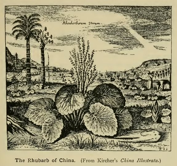
The Rhubarb of China. (From Kircher's China
Illustrata.)
At Agra Dorville died, but Grueber continued his journey through Persia and Asiatic Turkey to Europe. Being again ordered to China he thought to open a road through Russia, but his plans were frustrated owing to an invasion of that country by the King of Poland. He was attacked by dysentery and seems to have turned back without getting much beyond Constantinople dying in Germany in 1684. Some of Grueber's letters were published in the China Illustrata of Athanasius Kircher (Amsterdam, 1676),[1] and others in a small volume published at Florence in 1687, all being reproduced by Thévenot in his well-known collection of travels.
[1 Kircher was a German Jesuit of great learning, who held the post of Professor of Oriental languages at Wurzburg. The China Illustrata gives a general description of the country, with an account of the early explorations of the Jesuits.]
The next Jesuit journey to Tibet was made early in the next century for the purpose of establishing a mission at Lhasa. Meanwhile much had been done to improve the knowledge of China proper, the chief workers being now a body of French Jesuits, the first of whom left France in 1685 in the suite of M. de Chaumont, ambassador from Louis XIV to the King of Siam. They had been chosen for their knowledge of mathematics and kindred sciences, this being the most useful credential in the eyes of the Chinese emperor, now the famous Kang-hi of the Manchu dynasty. Of the party which left France, five, viz., Gerbillon, Bouvet, Le Comte, Fontaney, and Visdelou,[2] were destined for China, where in 1688 they were received by the Emperor on the recommendation of Verbiest.[3] The journey to Peking was made overland from Ningpo, through the provinces of Kiangnan and Shantung, and the route (as well as others subsequently followed) was fully described in the great work of Du Halde, to which reference will be made later. The French missionaries found favour at the court of Kang-hi, and one of their number, Jean François Gerbillon, was, as we have seen, despatched with the embassy to Siberia in 1688-89, subsequently accompanying the emperor on various expeditions to the Mongol countries north of the Great Wall. His journals, afterwards published by Du Halde, contain much information respecting those regions.[4]
[2 The sixth Jesuit was Père Tachard, who afterwards wrote the account of the embassy to Siam. The mission to the latter country included other ecclesiastics.]
[3 During the minority of Kang-hi most of the missionaries had been banished from Peking to Macao, but Verbiest had subsequently been employed as astronomer, and had persuaded the Emperor to relax the stringency of the decree.]
[4 Two journeys in the Emperor's train to Manchuria and Mongolia had already been made by Verbiest, but his accounts of them are but brief. On the first occasion (1682), Kirin on the Upper Zungari was reached, and Verbiest heard of the famous Chang-pei-Shan, in which that river rises.]
In 1688 Gerbillon proceeded north-west and west, crossing both branches of the Great Wall, to Kuku Khoto, and turning north across the steppes and sandy deserts inhabited by the Khalkas, then being attacked by the Eleuths. Great numbers of partridges and some deer were seen. Owing to the war, the Chinese embassy was recalled by the emperor, messengers being sent to acquaint the Russians with the reason, but it set out again the following year. This time the envoys took a nearly northerly course, passing the wall by the great gate near Kiu-pi-kiu. Then ascending the valley of the Lan-ho, past hills clad in oaks and pines, they crossed the desert with its hills of shifting sand, and passed the "Karu" or limits of the empire a little south of the Chona rivulet.[1] Beyond the desert they came upon the Kerlun or Kerulen, some eighty miles above Lake Kulun or Dalai Nor. It was not more than fifteen paces wide and three deep. They soon entered a region partly covered with forest and intersected with many streams running west to the "Saghalien" or Shilka. Their banks were much incommoded with quagmires. The Shilka itself was finally reached opposite Nip-chu or Nerchinsk, being there over seven hundred yards wide, and deep throughout. Nerchinsk is placed by Gerbillon in 51° 56' N., which is approximately correct.
[1 In about 46° 30' N. according to Stieler's Handatlas.]
The negotiations having been brought to an end, the Chinese envoys returned by the same route for the greater part of the way. The Kerlun was now so swollen by rains that the horses could only cross by swimming. After passing the steppe—where, in October, sharp frosts are experienced—they took a more easterly route by Mount Pe-cha, reaching Peking on October 22. Gerbillon subsequently made various journeys with the emperor through eastern Mongolia. In 1696 he accompanied the force which Kang-hi led against the Eleuths to the head waters of the Kerlun, and late in the year took part in a visit to the Ordos country within the bend of the Hwang-ho. In 1697 a more extended journey was made somewhat in the same direction, the Hwang-ho being crossed at Pao-te, the Great Wall skirted within Chinese territory, and the river again crossed to Ning-hia. On the return march the expedition proceeded north along the Alashan range and followed the course of the Hwang-ho, more or less closely, round its great northern bend to the point where it again turns south. Over forty observations for latitude were made during this journey.
The next year, 1698, Gerbillon made a still more extensive journey, this time in company with three Chinese officials sent by the emperor to hold assemblies of the Khalkas of Eastern Mongolia. The expedition left Peking in a N.N.E. direction, crossing the wooded ranges of Northern Pechili, and proceeding northwards across the western basin of the Liau-ho. The Khingan mountains, mentioned by Gerbillon as separating the streams flowing to the northern and southern oceans, were then crossed, and the first place of assembly was reached a little north of Pwir Nor, the effluent of which, the Urson, flows to Lake Kulun or Dalai Nor. Starting afresh in a northerly direction the expedition struck the south-western shore of Dalai Nor, where Gerbillon collected information respecting the lake and surrounding mountains, and then ascended the valley of the Kerlun, crossing and recrossing the stream as it swept to the south or north, and passing the ruins of Kara-hotun, built in the time of the Yuen dynasty. Near the point where the Kerlun first assumes its easterly direction that river was left, and the Tula, the first stream belonging to the Yenesei system, was struck. Both the Kerlun and Tula were correctly described to Gerbillon as rising in the Kentei mountains to the north. The country now became more agreeable, the Tula—considerably larger than the Kerlun—forming many tree-clad islands, and flowing rapidly through pleasant meadows and woods. Crossing the mountains to the north-west of the Tula, amid woods carpeted with wild strawberries, the expedition finally camped on the angle of ground between the Tula and Orkhon, where the second assembly was held. Here Russian merchants were encountered, from whom, and from a Khalka in their service, Gerbillon obtained much geographical information regarding the southern borders of Siberia. Among other points he learnt of the existence of the Altai, Khangai, Tannu, and other chains which give rise to the great Siberian rivers; obtaining besides a correct account of Lake Baikal from a Russian who had traversed it from end to end on the ice, as well as of the Jabkan and Kobdo rivers of northern Mongolia and the lakes in which they terminate. The camp near the Orkhon formed the turning point of the expedition, which made its way from the Kerlun across the Gobi desert to Kuku Khoto near the Hwang-ho, and thence to Peking. A large number of latitudes were again observed, which for the first time supplied the means of mapping with some accuracy a tract of country till then almost entirely unknown.
The mapping of the Chinese Empire was soon, however, undertaken on a more systematic plan. As we have seen, the Chinese maps of the nearer portions of the empire gave a fairly correct idea of its geography, but could not, of course, equal those based on astronomical observations. To revise and extend the existing maps was the task entrusted by Kang-hi to the French Jesuits, who in 1699 received a large accession to their numbers. In that year Bouvet returned from a visit to Europe with nine new missionaries, among them being Jean Baptiste Régis, whose name is above all associated with the great survey soon to be carried out. Already before 1705 the Jesuits had been commissioned to execute a survey of the plain south of Peking, where the emperor wished to restore the works of defence against inundations, and in 1708 they began a more extended survey in the neighbourhood of the Great Wall. In 1709 Régis, assisted by Jartoux and Fridelli, surveyed Manchuria from May to December, passing beyond the Amur, and also visiting the Ussuri region. The account of the journey contains a correct description of the Chang-pei Shan or Ever-white Mountain, which was found to owe its whiteness, not to snow, but to the loose gravel of which it is in part composed. It is not quite certain whether the Fathers actually visited the mountain, the time at their disposal having been scanty considering the great area with which they had to deal. They were near enough, however, to obtain some knowledge of northern Korea, and to prove once for all that that country formed part of the continent, as indeed had been shown in the best maps previously published. The interior of Korea remained outside the sphere of operations, but Régis afterwards gained some knowledge of the country from an ambassador sent there by Kang-hi.
On their return from Manchuria the Fathers surveyed the province of Pechili, the work being finished in 1710. The next year Régis turned his attention to Shantung, and subsequently, assisted by De Mailla and Henderer, to the other eastern provinces from Honan to Fokien. Finally, in 1715, after the death of Bonjour, who had begun the survey of Yunnan, the work was completed by Régis, who had then material for the whole map of the empire with the exception of Tibet.[1] For the astronomical survey of that country two lamas, who had received a mathematical training from the Jesuits, were despatched thither by the emperor, and in 1717 the results of their labours were placed in the hands of Régis. Though imperfect in many ways,[2] owing in part to the invasion of the Eleuths, the map, supplemented by information collected by Gerbillon and others, was a great advance on any which had been made previously, and until recent times was almost the sole basis for our knowledge of Tibetan geography. The courses of the Tibetan rivers, including the Sanpo, were laid down, and though their lower portions remained unknown, they were rightly considered to form the head-waters of the Yangtse, and of the great rivers of the Indo-Chinese peninsula. The information collected by the missionaries was eventually (1735) published in Paris by the Jesuit, Du Halde, accompanied by an atlas of maps by the celebrated geographer d'Anville; a second edition, with supplementary matter, being issued in 1736 at the Hague. Many interesting letters of the Jesuits were also published in the Lettres Édifiantes et Curieuses, edited first by Legobien and afterwards by Du Halde.
[1 Others of the missionaries who by their letters did much to increase the knowledge of China were Parennin, Premaire, Jartoux, and Gaubil.]
[2 Parts of the map were laid down merely from information derived from the lamas.]

D'Anville's Map of the Chinese Empire (Outline
sketch.)
Click on the map to enlarge it.
Brief mention must be made of the European journeys to Tibet made during the first half of the eighteenth century. In 1707 a party of Capuchins (Montecchio, De Fano, etc.) reached Lhasa. In 1715 Hippolito Desideri, a Jesuit, was directed to establish a mission at Lhasa, and succeeded in making his way, with Manoel Freyre, through Kashmir over high passes to Leh, and thence in 1716 to Lhasa, where the Fathers remained till 1729. Desideri gave a vivid account of the horrors of the mountain passes, the bare remembrance of which, he said, caused him to shudder. Soon after Desideri's arrival at Lhasa, a large party of Capuchin missionaries headed by Orazio della Penna, an Italian, made their way (1719) to the same city, travelling through Nepal. The mission established by Delia Penna laboured at Lhasa for over twenty years, having been reinforced in 1740 by a new party of friars taken out by the founder after a visit to Rome in 1735-38.[1] During this time a journey through Tibet, from India to China and back, was made by an adventurous Dutch traveller, Samuel van de Putte, who reached India in 1624 viâ Aleppo and Persia, and after travelling for several years in the dress of a native, arrived at Lhasa, where he dwelt for some years. His journey to China was made in company with a Tibetan embassy, and led him across the Upper Yangtse ("Bichu", i.e. the Di-chu of modern maps) which, being probably in a state of flood, it took him over a day to cross. The remaining route was probably that by Koko Nor and Southern Mongolia, but little definite information exists as to Van de Putte's travels, his voluminous papers having been destroyed, by his orders, after his death at Batavia in 1745.
[1 The party included Cassiano Beligatti, whose account of the journey to Lhasa was printed in Italy for the first time in 1901-2.]
With the decline of the influence of the Roman Catholic missionaries after the death of Kang-hi, the forward steps in geographical knowledge ceased for a time, China becoming once more closed to European travellers. The Jesuit accounts remained the principal authorities on the geography of the country, and not till the middle of the nineteenth century did explorers again visit the remoter regions of the interior.
{Page 143}
The greatest advance in geographical knowledge during the seventeenth century occurred in those quarters of the globe which, in the great discoveries of the previous period, had remained comparatively untouched by the explorer. In Australasia, in Northern Asia, and in North America, new lands were brought to light of which only the vaguest ideas were current during the Spanish and Portuguese period. Those regions, on the contrary, which had formed the special spheres of activity of early explorers, now entered upon a period of stagnation, and though some slight additions continued to be made to the general knowledge, these bear a relatively unimportant part in the history of geographical discovery. This is particularly the case with Africa, the continent which in the time of Prince Henry of Portugal saw the first systematic attempts to disperse the mists of obscurity which during the middle ages had enveloped more than half the surface of the globe. As has been often pointed out, Africa long felt the effects of a position on the road to the more attractive regions of the east and west, to the development of which all the resources of the conquering and trading nations of Europe were devoted. Whatever posts were established on the African coasts were regarded either as ports of call on the routes to the East or West Indies, or as stations for the supply of slaves to the plantations of the latter. Deprived thus of her labour-supply for the benefit of other newly opened lands, Africa was for over two centuries condemned to remain all but stationary both as regards the development of her resources and the prosecution of geographical discovery.
It was chiefly in the portion of the continent which lay nearest to Asia and was thus most in touch with events in the East Indies that the bounds of knowledge were extended, and here too, as in so many parts of the world at the time, the progress effected was mainly the work of Jesuit missionaries. Attention had long been directed to Abyssinia through the fame of its Christian potentate erroneously identified with the "Prester John" of earlier times, who was in reality an Asiatic prince. Even in the middle of the fifteenth century the famous world map of the Venetian Fra Mauro, constructed for King Alfonso V of Portugal, exhibited a surprising acquaintance with the geography of Abyssinia and the Galla countries to the south, though its author was naturally ignorant of the true relation of these countries to the rest of the continent.[1]
[1 Fra Mauro's map (1457-59) showed, among other features, the Abai with Lake Dembea, the Hawash, Lake Zuai, the Gibie (Xebe), Mount Zukwala (Xiquala), and the provinces of Amhara, Gojam, and Shoa (Saba) in fairly correct relation, though pushed far too much to the southward.]
The embassies of Payva and Covilhão (begun in 1487), of Alvarez (1520—27), and of Diaz and Rodriguez (1555), as well as the military expedition of Don Christopher da Gama in 1541, gave the Portuguese a personal acquaintance with the country and paved the way for the arrival of the Jesuits. The first party, headed by Bishop André de Oviedo, landed at Arkiko on the Red Sea in March, 1557, and though the reception accorded was not altogether favourable, the mission was maintained for 40 years without a break, the chief centre of activity being at Fremona in the province of Tigre. In 1597 the last representative of the first mission died, and work was in abeyance for several years.[2] An attempt to reach Abyssinia had been made in 1588 by Fathers Antonio de Monserrate and Pedro Paez, but being taken prisoners at Dhofar they were sent to Sanâ, the capital of Yemen, passing on the way the ruins of the ancient Melkis. Returning to India after seven years' captivity, Paez again set out for Abyssinia, which he reached in safety in 1603, being favourably received by the Emperor Asnaf Segued (or Za Donghel) in 1604. Paez resided in the country until his death in 1622, travelling, generally in the emperor's retinue, through its various provinces, and becoming acquainted with its geography and history. He wrote an account of the country and of its early rulers which after his death was placed in the hands of another missionary, Manoel d'Almeida, who embodied it in his Historia de Ethiopia a Alta, a volume which remained in manuscript down to the present day.[3] It seems, however, to have been utilised in the compilations of Balthasar Tellez, Kircher, and Ludolf, which present a general account of the history of the Jesuit mission in Abyssinia. Paez seems to have visited the source of the Blue Nile in 1613 (not 1618 as given by some authors), and his description, as given by d'Almeida and the historians just mentioned, is wonderfully accurate. He describes the course of the Abai through Lake Dembea and the rugged mountains of Gojam, with the cataracts of Alata, whose noise was said to make the inhabitants in their neighbourhood deaf. Paez also gives the correct explanation of the inundations of the Nile which had puzzled so many of the ancients, attributing them to the excess of rain which falls during the wet season in the Abyssinian highlands.
[2 The Jesuits are said to have been represented during this period by a secular priest, a native of India, Da Sylva by name.]
[3 It was printed in 1905-6 by Beccari in his Rerum Æthiopicariun Scriptores. Either the original or a copy is now in the British Museum.]
But the most adventurous journey undertaken by any of the Jesuits was that of Antonio Fernandez, who in 1613-14 penetrated far into the Galla countries south of Shoa. This missionary reached Fremona, by way of Suakin and Massaua, in July, 1604, in company with F.A. de Angelis. The Emperor Sultan Segued (or Socinios), who after some opposition finally established himself on the throne in 1607, showed much favour to the missionaries, who were settled near his Court on the shores of Lake Dembea. Being desirous of sending an embassy to the King of Portugal, and fearing the machinations of the Turks at Massaua, the emperor thought it preferable to despatch the expedition southwards towards Melinde. The Jesuits having been asked to send one of their number with the envoy, the lot fell upon Fernandez, who, though fully conscious of the difficulties of the route chosen, set out from Dembea in March, 1613. His journey, which is described by Tellez in his History of Ethiopia, led, in fact, through countries not again traversed until the latter part of the nineteenth century, but can by the help of modern maps be followed without difficulty for the greater part of the way. The most obscure part of the outward route is the first section, which led in a south-west direction through the country of the pagan Gongas to the Blue Nile at a place called Mina or Mine.[1] This was said to lie in 12° N., nearly due west of the source of the river, at the point where it begins to turn north, but as the centre of the province of Dembea was placed in 13° 30', or a degree too far north, we may look for the crossing point somewhere about 11°. This would place it in a region still very imperfectly known at the present day. Hence the journey was continued due south through the country of the Gallas to Narea or Enarea, next visited over two centuries later by the French traveller d'Abbadie; a large stream named Maleg (probably the Didessa or one of its tributaries) being crossed on the way. The people of Enarea (which is correctly placed in 8° N.) made an excellent impression on the traveller, no less for the sincerity of their character than for their fine physique. They carried on an active trade with their Negro neighbours in gold and other commodities.
[1 Mina is shown on some modern maps just north of the Blue Nile, in about 36° E., but on what authority does not appear.]
The ruler of Enarea put obstacles in the way of a further advance southward, insisting that the ambassador should take the easterly road through Bali, a district bordering on the Danakil country.[2] In this direction the first country passed through was that of Gingiro (Janjero of modern maps) which formed a sort of peninsula encompassed by the River Zebee (Gibie).[3] This had therefore to be crossed twice, on each occasion with some difficulty and danger. Fernandez learnt that Gingiro signifies monkey and considered that the name suited the king well in regard to both his personal appearance and habits. The travellers now entered the kingdom of Kambat and thence after a long detention proceeded to Alaba.[4] Still pursued by intrigues, the ambassador and his Portuguese companion were unable to advance further, but made their way back, with many adventures, by a new route apparently leading nearly due north from Alaba. Coming at last to an Amba or mountain inhabited by Christians, they received orders to repair to the Court, which was reached in September, 1614.
[2 Near the Hawash according to ancient (and some modern) maps.]
[3 There are two streams of this name, each starting in a northerly direction before turning south, and therefore forming a kind of peninsula as described. The district of Janjero is placed by modern travellers in the angle between the southern Gibie and the river of which the northern Gibie is the headstream.]
[4 Both these districts are to be found on modern maps, information respecting them having been first obtained, in modern times, by the Italian travellers Cecchi and Chiarini.]

Western portion of Ludolf's Map.
Click on the map to enlarge it.
Another Jesuit traveller, better known to English readers than either Paez or Fernandez through the translation of his narrative by Dr Samuel Johnson, was Father Jerome Lobo. This missionary embarked for Goa in 1622 in the fleet of Count Vidigueira, and being chosen soon afterwards for the Abyssinian mission, sailed from India in January, 1624, with the intention of finding an overland route from Melinde secure from Turkish interference.[1] Landing at Patta or Pate on the island of the same name, Lobo left his companion there and proceeded north along the coast in a native bark to the neighbourhood of the Juba river. Here he came in contact with the Gallas, who gave him no hope of finding a practicable route to Abyssinia, telling him of the constant wars that raged among the various nations on the way. The two missionaries therefore made their way back to India, where they found the Patriarch Alfonso Mendez about to set out for the mission. In his company Lobo reached the Red Sea, the various ports of which he accurately describes. The name of the sea he derives from the presence of a reddish seaweed growing in the shallow waters. A landing was effected at Bailur or Bailul, one of the less frequented ports just within the straits of Babel-Mandeb, and the missionaries made their way across the burning sands of the Danakil country, incurring some danger from the predatory bands which infested the country, but arriving safely at the mission station of Fremona after ascending the plateau escarpment. During his lengthened residence in the country Lobo became well acquainted with its various provinces. He frequently visited Gojam, the Agau countries, and other districts adjoining the Blue Nile, of which he gives a detailed description so far as it flows within the borders of Abyssinia.[2] He knew little of the countries beyond those borders to the west except that they were inhabited by Negroes with curled hair, whom the Abyssinians had been unable to subdue. The district of Fazokl near the point where the Blue Nile leaves the mountains was, however, known to him under the form Fazulo. Being assigned by his superior to the mission in Damot, Lobo crossed the Blue Nile and gained some knowledge of the southern portion of Damot, which then lay to the south of that river, though since overrun by the Gallas. The district of Ligonus, in which his work lay, is described by him as one of the most beautiful and agreeable places in the world, the air being healthful and temperate, and the hills shaded with cedars.
[1 Four of the party of missionaries who set out about this time for Abyssinia arrived in safety by the Red Sea route. Two others, however, after landing at Zeila, were beheaded by the native ruler. Another accompanied Lobo.]
[2 One journey was undertaken for the purpose of searching for the remains of the chivalrous but unfortunate Don Christopher da Gama, in which, to his great joy, he was successful.]
After the death of Sultan Segued a persecution arose, and some of the Jesuits were obliged to flee the country, while others suffered martyrdom. The same fate befel a party of Capuchins who thought to re-establish a mission in Abyssinia, and though an attempt was again made by the Jesuit Charles de Brevedent at the close of the seventeenth century and by German Franciscans early in the eighteenth, practically no addition was made to our knowledge during the century and a half after Lobo's time.
The work of the Portuguese Jesuits, recorded by the historians already alluded to, rendered Abyssinia the best known part of Africa during the period with which we have to do. In 1683 Ludolf constructed a map, based to some extent on one by Tellez, which is surprisingly correct in its general outlines. A photographic reproduction of its western half is given on p. 147. The former writer, who acquired much of his information at first hand from a native of Abyssinia named Gregorius Abba, severely criticises the maps of Africa produced by the Dutch or Flemish school of cartographers (Mercator, Ortelius, Janssonius, Blaeu, etc.) which were quite incorrect in their delineation of Abyssinian geography. Unfortunately these Flemish maps attained a wider currency than the more correct maps based on the Jesuits' accounts, and thus contributed to the maintenance of erroneous ideas respecting Central African geography. The manner in which they had been gradually evolved by stay-at-home geographers, on a Ptolemaic basis, has been spoken of in the introductory chapter, and is illustrated by the accompanying sketch-maps.

Evolution of Central African Cartography in the 16th
century.
Note. Waldseemüller's map of 1516 was preceded by that of 1507, in which the general idea was the same, though less developed. Mercator's of 1569 was similarly preceded by his globe of 1541, on the same general lines. Gastaldi's map of 1564 was the one most closely followed by Dapper and other compilers of the succeeding century.
One or two of the later journeys to Abyssinia, made about the close of the seventeenth century, deserve special notice on account of the different route adopted—that by Egypt and the Nile Valley. Father de Brevedent set out from Cairo in June, 1698, accompanied by a French doctor, Charles Poncet, whose narrative is our only authority for the events of the journey.[1] Beyond Siut, where the Nile was crossed by a stone bridge, the travellers took the route across the desert, by way of the oases, then usually followed by trading caravans bound for the Sudan. Poncet states that the Sudan lay to the west of Sennar, and that merchants went there in quest of gold and slaves. He mentions the great oasis—the last territory subject to the Grand Seignior—under the name Helawe—no doubt a corruption of El Wah, "the oasis." At Shabbe (Esh Shebb) the kingdom of Dongola was entered, and after the Selimeh oasis had been passed the Nile was again struck in the vicinity of the third cataract. After a halt at Dongola, the travellers entered the kingdom of Sennar, leaving the Nile at Korti and crossing the Bahiuda ("Bihouda") steppe to Derrera just below the sixth cataract. They did not see the confluence of the White and Blue Niles, as they crossed to the east bank and struck across to the Blue Nile above the confluence, this being still considered by Poncet as the main stream. On March 21, 1699, they were in the town of Sennar, the latitude of which is given as 13° on the authority of an observation by Father de Brevedent.[2] The heat was here found to be almost insupportable. The place was populous but ill-built; goods of all sorts were cheap, and a large trade with the East by way of Suakin was carried on by its merchants. Leaving Sennar, the travellers recrossed the Blue Nile and continued their route to the south-east, passing by Debarke (on the Dinder) to Giesim, half-way between Sennar and Abyssinia, wrongly placed by the father in 10° N., if Poncet's statement is to be trusted.[3] Subsequently crossing the Gandwa (Gundwa), the head-stream of the Atbara, Poncet and his companion reached the borders of Abyssinia, where, on the threshold of the hoped-for scene of his labours, the Jesuit father succumbed to a malady from which he had long been suffering. Poncet continued his journey to Gondar, where he claims to have been warmly received by the emperor, but some doubts have been thrown on the accuracy of this part of his narrative. His descriptions of the outward route are evidently faithful, and supply an interesting view of the political state of the country at the time, as well as details of its natural history. He says a good deal about Abyssinia, also describing the source of the Nile and Lake Dembea, to which last he gives the greatly exaggerated length of 100 leagues. After some stay in Abyssinia, his health compelled him, early in 1700, to turn his steps homewards, which he did through the provinces of Wogera ("Ogara"), Shire ("Siry"), and Adna, crossing the Takazze ("Tekessel") and Mareb ("Moraba"), and finally reaching Massaua, where he was well received by the Turkish governor. The English were at the time attempting to open a trade with Abyssinia, and an English vessel arrived at Massaua during Poncet's stay.
[1 An abridged version of Poncet's narrative was published in the Lettres Édifiantes et Curieuses. From the statements of Father Krump, whose journey will be mentioned later, it appears that three Franciscans also accompanied Brevedent.]
[2 The true latitude is 13° 36'.]
[3 Giesim is placed in some maps near the source of the Dinder in 12° N.]
The journey to Abyssinia by the Nile route was again undertaken more than once within a few years of Poncet's return.[1] In 1700 the Minorite Friar, Theodore Krump, received a commission from his superiors to join the expedition to Abyssinia then being organised by Pope Innocent XII. From Rome he went to Tunis, where he visited the town of Susa as well as the capital, and thence took ship for Alexandria. From Rosetta he went by boat to Cairo, and eventually to Siut, where he joined the bulk of the expedition. Six other fathers started with him for Abyssinia, the party including the Jesuits Grenier and Paullet, as well as four of his own order. From Siut the caravan took a somewhat different route from Poncet's, keeping to the river as far as Girgeh and then striking across the desert to the Ruins of Thebes. At Esneh the desert was again entered, and Poncet's route was joined at the oasis of Esh Shebb, beyond which it was followed pretty closely as far as Sennar. The desert routes from Girgeh to Thebes and from Esneh to Esh Shebb were not again followed, or at least not described by any European traveller, until recent years. At Sennar Krump remained behind to place his medical knowledge at the disposal of the ruler, while the rest of the party made their way to Abyssinia, accompanied by Paschalis, who had before resided at Sennar. So far as can be judged from Krump's account, they took a somewhat different route from Poncet's, but the party finally reached Gondar with the loss, through death, of one of their number. Having, after much opposition, obtained the adhesion of the emperor to the Roman Church, the survivors of the party started homewards. By this time several had succumbed to illness, and others fell victims to the climate during the return. Krump likewise started homewards from Sennar (June, 1702), and the journey was made by the already-followed route as far as Selimeh. Beyond this a new course was adopted, which took the caravan by an oasis called Luach by Krump, the identity of which seems doubtful. Krump published in 1710 a lengthy account of his journey, which contains detailed descriptions of the places visited in Egypt and Nubia. Like Poncet's narrative, with which it generally agrees, it emphasises the trade importance of Siut and Sennar.
[1 Poncet himself is said to have started again in 1703, accompanied by Father Du Bernat, but, on arriving at Jidda on the Red Sea, to have absconded into the interior of Yemen with the presents intended for the king, afterwards proceeding to Surat and Isfahan.]
Some geographical results were obtained by travellers on the west coast of Africa during the seventeenth century, but they were of much less importance than those gained in Abyssinia. In Senegambia and Upper Guinea the chief activity was displayed by the agents of trading corporations, which, though generally confining their activity to the coasts, made some attempts to penetrate to the supposed rich regions of the interior. Further south, in the old kingdom of Congo, some journeys were made by missionaries, but none of these extended to a great distance, though they did something to diffuse a knowledge of the countries visited.
The Portuguese monopoly of trade to West Africa had been challenged long before any voyages to the East Indies had been ventured on by the rivals of that nation. During the sixteenth century various trading voyages had been made to West Africa, particularly by the French from Dieppe, who directed their attention chiefly to the Senegal. From 1550 onwards English adventurers followed in their track in fairly quick succession, and in 1588 the first English Company for West African trade obtained a charter from Queen Elizabeth. In 1618 a more serious undertaking was set on foot, chiefly at the initiative of Sir Robert Rich, which led to the incorporation of the "Company of Adventurers of London trading into Africa." This company turned its attention to the Gambia, by which river it was hoped that a road might be found to the famous city of Timbuktu and the gold-producing regions of the Western Sudan.[1] A vessel of a hundred and twenty tons was despatched in 1618, under the command of George Thompson, who ascended the Gambia with the ship as far as a place named Kassan in 15° W. Proceeding to explore the river further in boats he made his way for some distance, but on his return found that the ship had been seized, and the crew murdered, by a party of Portuguese. The following year he again ascended the river, passing the Barrakonda falls and reaching Tinda, 25 or 30 leagues beyond. During this journey he learnt particulars of the caravan trade of those parts, and was already meditating the establishment of fortified posts on the river when his overbearing conduct led to his death at the hands of one of his men.
[1 A story is told by Barros to the effect that Timbuktu was reached by two Portuguese envoys towards the close of the fifteenth century, but the correctness of this is extremely doubtful.]
In 1620 two ships were fitted out and placed under the command of Captain Richard Jobson, who likewise ascended the Gambia as far as Tinda, and made enquiries relative to trade; but want of suitable goods for barter made the venture a failure. On his return Jobson wrote a full record of his proceedings, entitled The Golden Trade, with some account of Thompson's also and a description of the country and its inhabitants, so that the voyage led to some increase of knowledge. A fort seems to have been built on the Gambia in 1618, but it was afterwards abandoned, and Fort James was not finally established until many years later. On the Gold Coast, too, a fortified post was established in 1618 by the British Company.
It was to this latter coast that the Dutch turned their chief attention during this period. The formation, in 1621, of the Dutch West India Company, with a sphere of operations extending likewise to West Africa, was quickly followed by the establishment of posts on the shores of the Gulf of Guinea, where Fort Nassau, a little to the east of Cape Coast Castle, was founded in 1624. Before long the Dutch possessed no fewer than 16 stations on the Gold Coast, Elmina, wrested from the Portuguese in 1637, being the chief. Before the end of the century both the Danes and Brandenburgers also established themselves on the same coast, the former retaining their settlements until the middle of the nineteenth century. This commercial activity, though not leading to any journeys of exploration into the interior, did much to bring about a better acquaintance with the coast lands, which had its outcome in the careful descriptions of Dutch writers, such as Bosman and Barbot. The former lived 14 years on the coast, and, as most of his information is at first hand, his work is the most valuable early authority we possess on the Guinea coast. It includes also two letters written to him by other factors of the Company, the one, by J. Snoek, describing the Ivory and the Grain Coast, the other, by David van Nyendael, of special importance as one of the few original accounts of the country of Benin down to quite recent years.
The relations of the Dutch and other nations with the Guinea Coast extended round the head of the Gulf to at least as far as Cape Lopez, the numerous estuaries of the rivers being constantly visited for the purpose of obtaining cargoes of slaves. The Non and other branches of the Niger delta were known (though not suspected to be the mouths of a great river), as well as the Old and New Calabar, and many other streams. The account is extant of voyages to New Calabar and Bonny by James Barbot, brother of John Barbot, author of the Description of Guinea.
Meanwhile the French, as already stated, confined their attention almost entirely to the region of the Senegal, where they continued to trade, though for many years their posts were limited to the vicinity of the coast. The first French company seems to have been formed a little before 1626 among the merchants of Dieppe and Rouen, and not many years afterwards the first voyage up the Senegal of which we have any account took place. It is described by an adventurer who took part in it, Claud Jannequin, Sieur de Rochefort. The expedition, under the command of Captain Lambert, made the coast of Barbary and coasted down to Cape Blanco, where the adventurers landed to build a small vessel for the exploration of the Senegal. The country was found to be barren and waterless and the inhabitants wretchedly poor, living chiefly on fish. On reaching the Senegal the ship was left outside the bar, which was with difficulty crossed in the boat. Within the mouth of the river a small fort was built—apparently near the village of Biyurt on the east bank, not on the site of St Louis—and the voyage up stream commenced. The furthest point reached, "Terrier Rouge", is said to have been 70 leagues from the mouth and is placed on old maps in 15° W. During the ascent, trade was carried on with the Negroes for hides, ivory, gum arable, ostrich feathers, etc., but the season—the beginning of the rains—being unfavourable, it became necessary to return. The inundations of the Lower Senegal are accurately described by Jannequin, who, however, accepts the popular belief of the time that that river was the lower course of the Niger, or rather one branch of it, two others being supposed to enter the sea north and south of the Senegal respectively.
The Rouen Company was in 1664 merged into the French West India Company, which soon joined in the slave trade for the supply of the West Indian plantations. This turned its attention, like that of other European nations, to the Slave Coast and adjoining regions. One of the first voyages made on behalf of the West India Company was that of Villault de Bellefond (1666), who sailed along the Guinea Coast from the Senegal to the Gold Coast, touching at many points. An account of his voyage, with descriptions of the places visited, was published on his return, and soon afterwards translated into English. The account is also extant of a voyage by the Sieur d'Elbée to Ardrah or Jakin on the Slave Coast in 1670. It contains an account of the kingdom of Ardrah, which then occupied a large part of the present Dahomé. On the Senegal [1] operations were not attended with great success until the arrival of an energetic and capable Director-general in the person of André Brue (1697), who during his period of administration greatly extended the knowledge of the Senegal river.[2] In July, 1697, Brue set out on his first voyage, which had for its object the regulation of the trade with the Fuli (Fulas) on the north bank of the river, then ruled by a chief named the Siratik, whose residence was in about 13° W. The Senegal was full at this season, and with its wooded banks afforded a scene of great beauty. Owing to the strength of the current the boats were towed by Negroes, who worked often up to their waists in the water. The ledge of rocks called Platon de Donghel, which obstructs the river at low water in about 14° W., was passed without difficulty and, soon after, the furthest point previously reached by the French was passed. Brue did not himself advance beyond the Siratik's district, but sent on some agents, who reached the frontiers of Galam near the mouth of the Faleme, where they opened a trade in slaves, gold, and cotton cloths.[3] The Fulas were found to be of a distinct race from the Negroes, being tawny instead of black. They carried on a trade in gold and ivory with the "Moors" of the neighbouring countries.
[1 Some information respecting the countries adjoining the Lower Senegal was given by Le Maire, a French surgeon, who made the voyage there in 1682.]
[2 Before this the West India Company had made over its rights as regards the Senegal to a subsidiary association, in whose service Brue went out, succeeding the Sieur Bourgignon as Director. It should be noted that at least one journey, attributed by Labat to Brue, has been shown to have really been made by his predecessor La Courbe.]
[3 Barbot says that the Chevalier des Marchais ascended the Senegal to Galam about this time, and it is suggested by the editor of Astley's Voyages that the French traveller had been with Brue on this occasion. This is improbable, as Des Marchais himself says nothing about such a circumstance.]
Brue's second voyage up the Senegal was undertaken in 1698, when Galam was successfully reached, and Fort St Joseph established near the town of Dramanet, a little above the mouth of the Faleme. The inhabitants were for the most part Mohammedans, and the merchants traded as far as Timbuktu, said to be 500 leagues beyond. Brue obtained here some information respecting the intervening kingdom of Bambara, whence slaves were brought to Dramanet. After building the fort, he continued his ascent of the river as far as the rock Felu, which, stretching across the channel, formed a fall entirely obstructing navigation. This fall was examined by Brue on foot, the boat having been left two leagues below. It had been his intention to proceed as far as the Guina ("Govina") falls, but a sudden drop in the level of the river, amounting in 24 hours to no less than 18 feet, warned him to begin the return journey. During this expedition information was obtained of the gold-yielding country of Bambuk, and of the trade carried on by the Mandingos in those regions. Brue also made enquiries regarding Timbuktu, and was told that the city was not, as had been supposed, on the Niger, but at some distance from it. The accounts, however, were somewhat conflicting and threw some doubt on the identity of the Niger with the Senegal. Some years later Brue sent some of his men to push the discovery further, and these succeeded in reaching the Guina Falls (32 days' journey from the head of navigation on the Senegal), but advanced no further. One of Brue's agents named Apollinaire was stationed at Dramanet (Fort St Joseph) after the Director's return, in the hope of being able to make his way to Bambuk. In this he was unsuccessful, though he ascended the Faleme to the first rapids above its mouth and entered into friendly relations with the native chief of Kaynura. Things soon went badly, however, at Fort St Joseph, which had to be evacuated in 1702.
Brue does not seem again to have ascended the Senegal to so high a point as in 1698, though active in visiting other parts of Senegambia in the endeavour to stimulate trade. After negotiations with the English on the Gambia in 1700, he is said by Labat to have made his way overland to Cacheo, but this journey is now attributed to La Courbe. During a second tenure of office as Director-general he made an unsuccessful attempt (1714) to reach the lake of Kayor, to the north of the Lower Senegal, and in 1715 visited the country north of the mouth of the river, gleaning information respecting the gum trade, and the country which produced that commodity.

African Elephant. (From Labat.)
On his return to the Senegal Brue had at once taken steps to re-establish a trade on the upper river, where, in addition to Fort St Joseph, a station (Fort St Pierre) was now established on the Faleme. In 1716 the Sieur Compagnon, a chivalrous and enterprising pioneer, made his way to Bambuk, and his various journeys threw much light on the district between the Senegal and the Faleme. Campagnon first made his way across from Fort St Joseph to Fort St Pierre, afterwards following the east bank of the Faleme for a considerable distance, and striking across country to the gold district of Tambaura. He met with much opposition, but his affability and liberality finally overcame all obstacles, and he was able to examine the principal so-called "mines" in the country. The gold was found in alluvial deposits, but though the native methods of washing were very primitive, a considerable amount was obtained. Compagnon made a good map of the country between the Senegal and the Faleme, marking on it the positions of all the gold-yielding localities. He also collected information as to the plants and animals of the country, including a bird called the "Monoceros", which seems to have been a species of hornbill. Compagnon's explorations were not followed up for many years, and Bambuk formed the limit of the French acquaintance with the interior at this time.
The accounts of Brue and other officers of the French company were utilised by the Dominican editor of travels, J.B. Labat, in his Nouvelle relation de l'Afrique Occidentale, published in 1728, which contains a general description of the West African coast lands from the Senegal to Sierra Leone. Labat subsequently (1731) published an account of the voyage of the Chevalier des Marchais to the coasts beyond Sierra Leone in 1725-27. Des Marchais had made previous voyages to the same coasts, and Labat's work, which seems to have embodied other material collected by him, is one of the best authorities on the state of those countries at the time. It was illustrated by many maps and cuts—the former the work of the great French geographer d'Anville.[1]
[1 Only the first half of the work relates to Guinea, the latter part dealing with Cayenne, the ultimate destination of Des Marchais's voyage.]
We must now return to English enterprise on the Gambia, which, after the early voyages of Thompson and Jobson, was in abeyance for some years. In 1663, the year after the incorporation of a third English African Company named the "Company of Royal Adventurers of England trading to Africa", Captain Holmes, who had been sent to protect British trade in West Africa, founded Fort James on an island 20 miles from the mouth of the Gambia, and this soon became one of the most important trading stations of the English in the whole of Guinea. The Royal African Company, which in 1672 took the place of the Company of Royal Adventurers, endeavoured early in the eighteenth century to extend its operations inland, and attempts were made to explore the upper course of the Gambia in the hope of discovering gold mines in that direction. In December, 1723, Captain Bartholomew Stibbs started from Fort James on a voyage up the river with the ship Despatch, a sloop, and five canoes, the whites of the party numbering eighteen. The Despatch was left at Kuttejar (in about 14° 35' W.) and the sloop at Barrakonda, the voyage being continued in the canoes. The time of year was unfavourable, the start having been delayed, contrary to Captain Stibbs's wishes, until too late in the dry season, and much difficulty was experienced from the lowness of the river. The first fall occurred about three leagues from Barrakonda, and extended right across the stream, so that almost a whole day was occupied in getting the canoes past it. Shallows became numerous above, and, after passing two more rocky falls, progress was completely stopped by the shoals at a point about 59 miles above Barrakonda. Stibbs sent one of his men to search for the reported York River, said to be situated 17 leagues above Barrakonda, but he returned without success, having, during a day's journey, found only dry channels entering the main stream. This was so shallow that it had several times been forded. The result of this voyage was to induce Stibbs to doubt the correctness of the current idea that the Gambia formed one of the mouths of the Niger, for he had heard from the natives that it came from the gold mines, twelve days' journey from Barrakonda, and that it had no connection with lakes or any other river. He was also correct in supposing that the Senegal also was independent of the Niger, rising comparatively near the coast; but his views did not meet with general acceptance, and the old idea maintained its ground many years longer.
One of the fullest accounts of the countries on the Gambia at this time is that of Francis Moore, who went out at an early age, in 1730, as factor under the Royal African Company, and during his residence in the country made many journeys up and down the river. His book, published in 1738, is in the form of a journal, but contains many descriptions of places on the river and the state of trade at the time. It includes the account of Captain Stibbs's voyage, and some particulars respecting Job ben Solomon, a native of Futa Jallon, who had been taken as a slave to Maryland, but had been redeemed and sent back to his country. During his stay in England, an account of his life and adventures had been drawn up by a Mr Bluet, and this contains some information respecting the then unvisited country of Futa Jallon. Moore's book contains, in addition to various cuts, a map of the Gambia as far as Barrakonda, based on a survey by Captain John Leach, which a comparison with modern maps shows to have been remarkably accurate.
Passing now to the more southern parts of West Africa—Congo, Angola, and neighbouring regions—we have again to do principally with the work of missionaries, who were now the most energetic travellers in the Portuguese colonies. The Congo river and the kingdom of the same name were, it is true, visited by Dutch traders before the end of the seventeenth century, but they added little to the geographical knowledge of those countries. The missionaries who laboured in Congo and Angola during the seventeenth century belonged to the order of Capuchins, whereas in the sixteenth the work had been carried on by Dominicans and Franciscans. The best authority on the travels of the Capuchins and on the geography of the region in question, as known towards the end of the seventeenth century, is the work of G.A. Cavazzi da Montecuccolo, who himself laboured and travelled in those countries. It is entitled Istorica descrizzione del tre regni Congo Matamba e Angola (1687). This work formed the basis of a description of the country by Labat, who, after publishing the accounts of Upper Guinea to which reference has been made above, turned his attention to the more southern regions with a view to completing his account of the whole west coast. His Relation Historique de l'Ethiopie Occidentale which is the title of the third of the series, was published in 1732 and, like the former works, contains maps by the great French geographer d'Anville. The journeys of some of the Capuchin missionaries extended a considerable distance into the interior—in some cases through districts hardly visited by Europeans since their time. Their routes cannot be laid down with precision, but the approximate direction followed by each can be guessed at with some confidence, confirmation being supplied in some cases by the light of recent discoveries. One of the most important journeys from a geographical point of view was that of Girolamo de Montesarchio, who in 1657 is said to have made his way from San Salvador—the capital of Congo—to Sundi on the Congo (evidently the country of the Basundi tribe) and thence along the north bank of the river to a place named Concobella, supposed to lie on the borders of the kingdom of Makoko. One of Dapper's names for the inhabitants of the kingdom (Meticas) enables us to identify it with the land of the Bateke north of Stanley Pool. The return journey was made by a more easterly route by the "sacred tree" at Gimbo Amburi. This would seem to be not a solitary instance of penetration to so high a point on the Congo, for, in the account by the Capuchin Merolla of a voyage to Congo, etc., in 1682, we are told that a certain missioner travelled into the country of Makoko and died there after baptising 50,000 souls. The country, however, remained practically a terra incognita until Stanley's great journey of 1877.
Another important journey seems to have been made beyond San Salvador on the south side of the Congo as far as the Kwango, its first great southern tributary. Nothing appears to be known of the name of the traveller who made this journey, but from the fact that the route is laid down with considerable detail in the map accompanying Dapper's Africa, and reproduced by Delisle, d'Anville, and other cartographers of the first half of the eighteenth century, there seems little doubt that such a journey was made. On the map alluded to, the route is shown as running generally parallel with the lower Congo at a little distance to the south, but this probably is due to accident, as it does not touch the river at any point, and our present knowledge enables us to trace the general direction of the march at an average distance of perhaps 100 miles from the river. From San Salvador it led almost due north-east, finally striking the Kwango at a place called Condi, with Canga on the further bank.[1] Now, apart from the correct name given to the river, these two places can be identified as representing the town of Muene Kundi or some other centre of the land of the Bakundi, which lies on the Kwango at just the point where it was most likely to be struck; and the adjoining country of the Bokange or Bocanga. The places inserted on the earlier part of the route cannot be positively identified, but in general form and the prefixes employed they agree well with those of the country which would be passed through.
[1 The Condi country was also known to Dapper from the reports of the Dutchman, Jan van Herder, who had heard that beyond the Kwango dwelt a race of men of light complexion and long hair.]
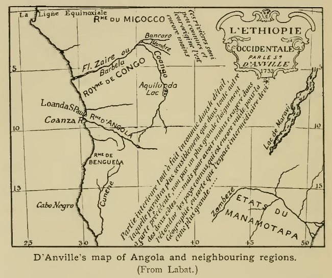
D'Anville's map of Angola and neighbouring regions. (From
Labat.)
From Dapper's time onwards the Kwango figured in maps of Africa, either correctly as a southern branch of the Congo (representing the Barbela of previous writers) or, as in Delisle's map, as the main stream of the river. The fact that Delisle and others who followed him pushed the upper course of the Kwango much too far to the east, coupled with the similarity of names, has led some to the incorrect conclusion that the central course of the Congo was known to the Portuguese. That this was not the case is further shown by the fact that the upper courses of the Kwanza and Kunene are pushed as far to the east as that of the Kwango, all being placed near together between Lat. 6° and to° S. In Delisle's map the large Lake Aquiluna of Pigafetta, which was retained by Dapper, is shown merely as a swamp of comparatively small extent.[1] It was the merit of the great geographer d'Anville to reduce the mapping of the known regions adjoining the African coasts to fairly correct proportions, bringing out clearly the extent of quite unknown country in the interior. His justification for this course is well stated on the map in Labat's work on Congo and Angola, of which an outline sketch is here given.
[1 The Lake is named "Chilande" (Kilande) or Aquilonda by Cavazzi da Montecuccolo, and is said to be situated in Sissama, a part of Matamba (see next page). It is probably represented by one of the small lakes recently found to the north of Matamba. The effluent of the lake "Barbola" is said by the same writer to be a tributary of the Kwango, not, as Dapper thought, the Kwango itself.]
Another missionary journey which deserves mention is that of Fathers Bonaventura and François van Batta from San Salvador to the east and south-east in 1649. Passing the district of Zombo (the Zombo plateau of modern maps) these travellers reached a place called Inkussu, which name may possibly represent the Lukussu, a branch of the Inkissi, which joins the Congo below Stanley Pool. Further south, the upper course of the Kwango was reached by more than one missionary, including Cavazzi da Montecuccolo himself. This traveller, as we learn from Labat, made his way from the Kwanza to the camp of the Jaggas near Kassanje.[1] He seems to have crossed the Tala Mungongo range by a pass considerably to the south of Kassanje, for the last three days of his journey led north through rich and well-cultivated plains. Dapper, who published his work in 1668, had of course no knowledge of the results of this journey, which were however utilised by Delisle, who marks Kassanje and the Jagga country on the left bank of the Kwango. Kassanje was also reached (before 1667) by Jean Baptiste de Sallizan, who, as we learn from Angelo and Carli's account of their journeys, likewise meditated a visit to the country of Matamba to the north. This district, which appears on Pigafetta's map and on most maps of the period, seems to have been fairly well known to the Portuguese, for its queen was said to have adopted the Roman Catholic religion.[2]
[1 The Jaggas were a warlike tribe which came from the east and devastated this part of West Africa during the seventeenth century.]
[2 Carli calls the country Malemba or Mattemba, while Dapper, following Pigafetta (map of Congo), gives Matemba and Matama, though the latter in the map of Africa has Matemba only. There is possibly a confusion with the district of Malemba south of the Kwanza. Matamba of modern explorers is a district west of the middle Kwango.]
Several other accounts of the country were written by members of the Capuchin missions, though as a rule they deal little with geography. The best account of the earlier stages of the Congo mission is that of Fragio (1648). Better known—by reason of their having been translated into English—are those of Angelo and Carli (1672) and of Merolla de Sorrento (1692) already referred to; while, still later, an account of travels principally to the coastland south of the Congo was published by a missionary named Zuchelli (1712).
In South and South-east Africa very little advance was made during the seventeenth century. The establishment of a settlement by the Dutch at the Cape (1652) brought little addition to geographical knowledge until much later. A short description of the Hottentots was published by a Dutch traveller, William Ten Rhyne, who visited the Cape in 1673; but a fuller and more reliable account was that of Peter Kolbe, a German savant sent out at the beginning of the next century to make astronomical observations at the Cape. His work also gives an account of the Dutch settlements, limited at the time to the extreme south-west corner of the present Cape Colony, and it is illustrated by maps and plans and contains numerous observations. His general map shows the usual tendency to exaggerate the distances of interior places from the coast.[1] The Portuguese territories on the east coast were already verging on decadence at the beginning of the seventeenth century, and although the Monomotapa's kingdom was still frequented for a time, both by adventurers and missionaries, hardly any additions to geographical knowledge were made. A single exception is perhaps the journey of Bocarro to the north of the Zambezi in 1616. Bocarro seems to have reached the neighbourhood of Lake Nyasa, of which thenceforward some vague notions were current among the Portuguese settlers. It was not, however, till early in the eighteenth century that cartographical representations of the lake gave any indication of its actual form.[2]
[1 The beginnings of exploration in the latter part of the seventeenth century are spoken of in Chapter xv.]
[2 D'Anville's map (see p. 164) shows a long and narrow lake, named Maravi, in the position of Nyasa.]
In Madagascar and the neighbouring islands the seventeenth century brought some additions to knowledge, through the endeavours made by the French to establish settlements in them The first steps for this end were taken in 1642 by the inauguration of the Société de l'Orient, which soon sent out agents who took possession, in the first place of Antongil Bay and the small island of Sainte Marie, and subsequently of other places on the east coast of Madagascar. The chief station was founded near the south end of this coast, and named Fort Dauphin.
In 1648 an energetic governor arrived in the person of Étienne de Flacourt, who established French influence over a considerable area and explored some of the interior. After his return to France he published (1648) an account of Madagascar which marked an important advance in knowledge respecting the island. In 1664 the French settlements passed to the newly-formed East India Company, but little was effected, and only six years later they became the property of the French Crown. During the Company's connection with the island the Governors were respectively MM. de Rennefort and Mondevergue, the former of whom wrote an account of his voyage to Fort Dauphin. Between 1669 and 1672 Madagascar (then known as Dauphiné) and Réunion (Bourbon or Mascarenne) were visited by a M. Dubois, who in 1674 published an account of his voyages, with descriptions of the remarkable fauna of Réunion, including the dodo and the gigantic land tortoises. A most interesting account of Rodriguez and its equally strange fauna—which modern research has shown to be very accurate—was written some years later by François Leguat, one of a party of Huguenot exiles who attempted in 1691 to found a colony in the island. Réunion had been the original destination of the party, but the plans were changed when it became known that the more fertile island had been annexed for the French East India Company. After many hardships, including an imprisonment by the Dutch, Leguat reached Europe in 1698, but his MS. was not printed until 1708. In Madagascar no geographical results of importance were achieved after the time of Flacourt until past the middle of the eighteenth century.
{Page 168}
The course of discovery in South America during the seventeenth century presents many analogies with that in Africa, and may be suitably spoken of in this chapter. The two continents had both been the scene of important events during the century or more which had preceded the opening of our period, and in both cases this was followed by a time of relative standstill, in which no sensational discoveries were made, though the work of a multitude of lesser men gradually added to the accumulated stock of knowledge. In both continents the work of missionaries, especially of the Jesuits, played an important part in the process, though in South America, more than in Africa, this was supplemented by the quest for gold and other minerals, and the raiding for slaves, especially in eastern and southern Brazil. In South America far more had been done than in Africa during the sixteenth century, and the farther advance was therefore made from more forward bases. The extent of country of which a more or less accurate knowledge had been acquired before the beginning or middle of the 18th century was thus far greater in the western continent, and while at the close of our period the greater part of inner Africa remained a complete blank, it was only the most remote recesses of South America that were still quite unknown at the same point of time.
The advance in South America was carried on from three main quarters,—the Spanish settlements in the La Plata region; the Portuguese settlements in the eastern and southern parts of Brazil; and Peru. In the region of the La Plata, and the various great rivers which pour their waters into its estuary, it was to the Jesuits that the results achieved were especially due. While the principal government stations were on the sea-board or in the lower basin of the great rivers, the missionaries pushed farther afield, and during the seventeenth century brought into existence a vast system of "Reductions", as the settlements of converted Indians were then called. From the older centres they kept spreading their influence over the more remote districts, and a good deal of new country was thus brought within civilised ken.
In the early decades of the century one of the most active among the Jesuits of this region was Father Roque Gonzales de Santa Cruz, who, after being for some time at the head of the reductions of the Paraná, in 1620 founded a new centre on the Uruguay. In 1623, the governor of Buenos Aires, Don Luiz de Cespedes, sent the Jesuit Romero to explore the latter river from mouth to source, and the journey, though only in part successful, brought the traveller to the first Guarani tribes, 100 leagues from the starting point. In 1626 Gonzales attempted the exploration of the Sierra de Tape, a beautiful mountainous district east of the Paraguay province, drained in part by the Ybicui, a tributary of the Uruguay. It was his great desire to open a direct road to the sea from the Paraná missions, and with this view he now explored the country of the Caaroans, near the Uruguay. But misfortunes awaited these promising endeavours, Gonzales being murdered by natives in 1628, while in 1630 the Spanish missions had to suffer from the incursions of lawless adventurers from the Portuguese province of São Paulo, whose inhabitants had shown particular activity in pushing west into the unknown interior. Attacking the mission stations, they carried off numbers of the converts into slavery, and caused such general havoc that the Jesuits found it necessary to evacuate the whole of the Guayra district, and embark on the Paraná and seek a home less exposed to attacks from the north. Further misfortunes overtook the fugitives during this arduous journey. Some new attempts to open settlements were made in the Sierra de Tape and in the district of the Itatines tribe east of the Paraguay, but the Paulistas again attacked and devastated the missions, and the fathers were forced to remove to the narrowest part of the tract between the Paraná and the Uruguay. The missions thus entered upon a period of retrogression, and though some advance was again made before the close of the century, it was rather from the side of Peru that subsequent forward movements were initiated.
From the side of Brazil, although considerable activity was displayed by Jesuit missionaries, it is rather to the journeys of lay adventurers in quest of slaves and minerals that the breaking of most new ground is to be credited. The daring enterprises of the Paulistas or settlers in the province of São Paulo have already been referred to. Although slave-hunting was the motive of many of their raids, they also turned their energies to the search for mines, though in this they met with rivals from other provinces, with whom they eventually came into open conflict. It was only after many years of arduous endeavour that the rich mineral deposits, both of gold and precious stones, were at last brought to light. About the middle of the seventeenth century, one Marcos de Azevedo pushed his way up the Rio Doce and Rio das Caravellas, bringing back specimens both of silver and emeralds. His refusal to divulge the locality in which they occurred brought him into conflict with the authorities, and he died a prisoner. The search was taken up some years later by the government, but with little success until an enterprising prospector came forward in the person of Fernando Diaz, a veteran of 80, but possessed of such energy that within a few years he explored almost the whole of the future province of Minas Geraes, opening up settlements and prosecuting his journeys amid great difficulties and hardships. He was rewarded by the discovery of emeralds, but soon afterwards died of a fever. The next adventurer deserving mention is Bartolomeu Bueno de Sequeira, who carried on a successful search for gold during the last decade of the seventeenth century. Early in the eighteenth, a great influx to the mines took place, and the province of Minas Geraes became thoroughly opened up. That of Goyaz, another of the provinces rich in minerals, had to wait longer for its development, although certain adventurous spirits had penetrated to this remote region before the close of the seventeenth century. The first of these is said to have been one Manoel Correa, a Paulista, who was followed by Bartolomeu Bueno—the elder of two individuals, father and son, bearing that name. The exact routes followed by this adventurer cannot now be laid down, but he seems to have found gold in the basin of the Araguaya (the great western branch of the Tocantins or Pará river) and to have possibly entered the neighbouring basin of the Xingu, one of the great southern tributaries of the Amazon. It was not till the third decade of the eighteenth century that these discoveries were followed up, Bartolomeu Bueno the son being then one of the first to form a regular settlement at the site of the future mines.
In northern and north-eastern Brazil we again find Jesuits among the most active agents in the opening up of new districts, though some notable journeys were made in quest of the mythical realm of "El Dorado" (the "golden" monarch). Thus in the first few years of the seventeenth century Gabriel Soares undertook this quest, making his way to the head of the Rio São Francisco and beyond; but he was forced to return, though not before he had done something to extend the bounds of knowledge. Two separate expeditions were undertaken about this time by Pedro Coelho de Sousa, who in the second of them, accompanied by a large party of adventurers, went overland from Maranhão to Ceará, and thence reached a point not far from the Serra de Ibiapaba, separating the basin of the northern Paranahiba from some of the western tributaries of the São Francisco. The Jesuits, too, took up the attempt to reclaim the Tapuyas of this range, though it was not until some time later that any great progress was achieved. From Pernambuco, where, during the war with Spain and Portugal, the Dutch had established themselves in 1631,[1] some journeys were likewise made into the interior for the purpose of searching for mines. Two Dutch deputies are said to have made their way across country as far as Cuyaba, a journey of some 1500 miles in a direct line, through country then but imperfectly known. Among the Dutch officials who added to the general stock of knowledge was Jan Nieuhoff, whose journeys were described in an illustrated work which was long one of the standard sources of information on Brazil.
[1 Bahia, then the capital of Brazil, had been captured by the Dutch in 1624, but had been retaken in 1625.]
An event which proved of much importance for the opening up of the Amazon valley was the founding, in 1616, of the city of Pará, or, to give it its full name, Santa Maria de Belem de Gran Pará. This took place while Caspar de Sousa was governor of Maranhão, the officer entrusted with the task being Francisco de Caldeira. Although the actual site of the settlement was ill-chosen, its position relative to the two great river systems of the Amazon and Tocantins (the latter named, like so many of the Brazilian rivers, from the tribe on its banks) gave it particular advantages as a starting point for expeditions into the interior, though for some time those in charge signalised their periods of office chiefly by carrying devastation into the neighbouring districts. The impulse towards more extended exploration came from the side of Peru, and the fact that since 1580 the Spanish and Portuguese dominions had been united under one crown was of importance as encouraging co-operation between the Spanish and Portuguese authorities on the opposite sides of the continent. The progress of missionary enterprise from the side of Peru will be spoken of presently, but it must be mentioned here that a party of Franciscans had been despatched from Quito in 1635 to evangelise the Indians on the Aguarico, a tributary of the Napo, and that they were escorted by an officer, Juan de Palacios, who had previously been in charge of a fort in the upper basin of that river. Palacios founded a settlement near the mouth of the Aguarico, among a tribe of Indians known to the Spaniards as "Los Encabellados", in reference to their long hair, but was attacked and killed by these people, most of his companions making their escape to Quito. Two friars, however (Domingo de Brieba and Andres de Toledo), with six soldiers, happening to be away at the time of the attack, did not return with the rest, but launching a canoe on the Napo (June, 1637) committed themselves to its waters and those of the main Amazon, and after an adventurous voyage finally reached Pará in safety. This was but the third time, so far as is known, that the descent of the Amazon had been accomplished, the two previous voyages being those of Orellana and of the "tyrant" Aguirre, both in the sixteenth century.
This event naturally directed attention to the possibility of navigating the Amazon, and an expedition was at once organised at Pará under Pedro de Teixeira to explore the river route to Quito. This officer had already been employed on important undertakings, having been with Caldeira at the founding of Pará, of which settlement he became governor, for a time, in 1618. He had also fought successfully against the Dutch, and had ascended the Amazon and its tributary, the Tapajos, in quest of slaves. He started on his new mission towards the end of 1637. The ascent of the great river was naturally a more arduous undertaking than its descent by the two friars, and though these accompanied him on the journey, their voyage had been too hurried to permit of surveys which might have helped the Portuguese explorer to trace his upward route. Sending forward his associate, Colonel Bento Oliveira, a man known and respected by the Indians, to reconnoitre, Teixeira followed with the main body, and thus little by little accomplished the tedious journey, until territory under the jurisdiction of Quito was at last reached.[1] Here the main body was left behind under Pedro da Costa, while the commander pushed on to Quito, which he reached in safety in the autumn of 1638.
[1 After leaving the main Amazon, the party does not seem to have ascended the Napo, but another stream named by the voyagers Quijos, from the tribe living on its banks.]
But his task was not yet ended, for he was ordered by the authorities to return to Pará by the same route, in order to perfect his survey of the rivers. Two Jesuit priests, Cristoval d'Acuña and Andres de Artieda, were assigned to him as companions, and were instructed to note down all that was of interest regarding the country and peoples passed on the way. The account published by Acuña in 1641 contains the observations of the fathers, and forms one of the most important early documents on the Amazon and its tribes that we possess. The voyage was carried out in 1639, being begun in February of that year, and this time the route down the Napo was the one adopted. During the further voyage the mouths of all the great tributaries of the main river were noted, and they are mentioned by Acuña under names differing little from those still in use. We find the Portuguese names for the two greatest tributaries—Rio Negro and Madeira—already established, the former given on account of the clear black water,[1] the latter in reference to the amount of driftwood brought down by the current. Information was likewise obtained of the connection between the systems of the Amazon and Orinoco by means of the Cassiquiari, though Acuña refused to admit that the northern river he heard of was the Orinoco. A project was set on foot by some of the party to ascend the Rio Negro in quest of slaves, but it was frustrated through the influence of the priests. Lower down, however, Teixeira found slave-hunting operations in full swing on the part of the Portuguese from Pará.[2] Like other travellers nearer our own time, Acuña gave credit to the accounts of tribes of Amazons (female warriors) living in the interior districts, and he narrates the usual fanciful details about them. Finally the expedition reached Pará on December 12, 1639, the double journey across the continent having thus occupied just two years.
[1 The black water of many of the South American rivers, especially those which flow through the forest-clad regions, is a remarkable phenomenon, which has long engaged the attention of geographers.]
[2 Intercourse with the region of the lower Amazon and its tributaries had been maintained for some years before this, on the part not only of the Portuguese but of the Dutch and English. Between 1614 and 1625 the Dutch had forts both on the main Amazon and on the Xingu. Acuña heard a story of an English vessel which had ascended the lower course of the Tapajos.]
About the middle of the century a new turn was given to affairs in northern Brazil by the association of two men of high character who laboured with single aim for the improvement of the lot of the natives, whom the rapacity of the settlers had too often reduced to a state of misery. These were Vidal, governor of Maranhão, and the Jesuit Vieyra, who both worked zealously for the freeing of slaves and the civilisation of the Indians of the interior. Two Jesuits were despatched up the Tocantins to "reduce" the Topinambazes of that region, while a little later Father Manoel de Sousa made his way to the Xingu and Tapajos rivers and the country of the Juruunas. About the same time expeditions were undertaken in search of minerals to the Serra dos Pacajas, but they met with no success.
One of the chief preoccupations at this time, both of the civil government and of the Jesuits, was the opening of an overland route from Maranhão to the south-east, or towards Pernambuco. After several vain attempts had been made, the Jesuit Ribeiro succeeded in reaching the Serra de Ibiapaba, already mentioned. Here a mission was established, and the desired overland communication with Pernambuco at last opened. Ascents of the Amazon and its tributaries continued to be made. In 1656 Francisco Velloso and Manoel Pires brought back slaves from the mouth of the Rio Negro, and soon afterwards Pires, accompanied by Father Francisco Gonçalves, ascended that river and returned to its mouth with over 600 ransomed captives. The father, however, soon afterwards died. A military expedition, also accompanied by Jesuits, ascended the Tocantins, the fathers reaching a point in 6° S. The interior thus gradually became better known, and, with the eventual advance on Goyaz from the south, there remained but a small part of eastern Brazil altogether untouched by Portuguese enterprise. Large tracts within the Amazon basin still remained unknown, both north and south of the main river, and some portions remain unexplored at the present day.
From the side of Peru by far the greater part of the advance during the seventeenth century was due to the missionaries. From Quito, the Jesuit Rafael Ferrer went in 1602 into the country of the Cofanes Indians, where he established a mission, afterwards (1605) pushing on down the Napo to the Marañon. He was murdered, however, in 1611. In 1616 some Spanish soldiers made their way into the country of the Maynas, in the valley of the Marañon, where a settlement was soon afterwards founded by Don Diego de Vaca y Vega. In 1638 a Jesuit mission was established in this district by Fathers Cueva and Cujia, who with some others also explored some of the neighbouring regions. Somewhat later, much exploring activity was shown by Father Raymundo de Santa Cruz, who from his station among the Cocomas of the lower Huallaga opened up a route to Quito by way of the Marañon and Napo. He was attempting the ascent of the Pastaza in 1662 when he was drowned by the upsetting of his canoe in a rapid. Still later, from 1684 onwards, the names of two Germans, Henry Richter and Samuel Fritz, were notable among the many missionaries who laboured in the region of the Marañon and made journeys on the various rivers, or through the dense forests. Fritz in particular descended the whole course of the Amazon to Pará and wrote a valuable account of the great river, besides compiling a map.
Meanwhile other missionaries, from a more southern starting-point, had pushed east into the valleys of the south-western tributaries of the Amazon, including the various branches of the Ucayali, which has some claim to be considered the real headstream of the great river. Here it was the Franciscans who did the chief pioneer work. In 1631 Father Felipe de Lugano set out from Huanuco and, after pushing east to the valley of the Huallaga, established a mission. In 1637 Jeronimo Ximenes and Cristoval de Larios descended the Perene, but both were murdered by Indians. Others, however, followed in their steps and founded stations on the Chanchamayu, but, pushing on by the Perene to the Ucayali, they too fell victims to their zeal, being murdered by the Setebos Indians. Though many others ventured into these pathless wilds, the missions in this region encountered unusual obstacles, and many were the vicissitudes they passed through.
The head-waters of the great Madeira, largest of all the Amazon tributaries, were also reached from Peru both by missionaries and by lay adventurers. About the middle of the seventeenth century, some advance was made into and beyond the province of Carabaya, south-east of Cuzco, towards the country watered on the north-west by the great river known to the Spaniards as Madre de Dios,[1] and on the east and south by the Beni. The people of this region were known to the missionaries as Chunchos. One of the first to undertake the conquest of this country was Don Pedro de Allegui Urquizo, who, among other posts, founded that of Apolobamba. He had with him some Augustinian friars, but these do not seem to have done much in the way of missionary work among the Indians, and it was to the Franciscans that the results achieved somewhat later were principally due. On the lay side, a special incitement to exploration was supplied by legends of a remnant of the old Inca dominion, supposed to have maintained itself in the vast forests to the east, when Inca rule on the Andean table-land was brought to an end by the Spanish conquerors. A ruler named Paytiti was so constantly spoken of as holding sway in these regions that some, even in modern times, have thought that a real foundation for the story must have existed. Be this as it may, several expeditions were undertaken in quest of this supposed kingdom, one of the most important being that carried out under the orders of Don Benito Quiroga in 1670. Crossing the eastern range of the Andes, and launching a fleet of canoes on one of the great rivers (apparently the Beni), the expedition pushed down stream for some distance, but was compelled to beat a toilsome retreat. In 1680 a party of Franciscans, including Fathers Sumeta, Corso, and De la Peña, began their labours in the district of Apolobamba, where they and their successors in time established a number of stations, besides pushing a considerable distance into the wilds beyond.
[1 If the account of the adventurous journey of Maldonado (sixteenth century) is to be trusted, this "conquistador" had then made his way down the course of the Madre de Dios, but this advance was not followed up at the time.]
A more easterly headstream of the Madeira—the Guapay or Mamore—was the scene of an important Jesuit mission, which laboured among the Moxos or Mojos Indians.[1] The first attempt on the part of the Jesuits to convert these people seems to have been made about 1668, by Fathers José Bermudo, Julian de Aller, and others. A few years later Brother José del Castillo made his way to the Moxo country, and it was through his influence that Father Cypriano Baraze, the most devoted of all the missionaries to this tribe, was induced to offer himself for the work. During his many years' labours among the Moxos (in which his first coadjutor was Father Pedro Marban), Baraze made extensive journeys into the surrounding regions, descending the Mamore a long distance, and extending the work of evangelisation among the tribes beyond the Moxos. One of his most arduous journeys was that in which, after previous vain attempts, he succeeded in tracing a direct route across the mountains from the Moxo country to Lima. This is said to have been in part the same as that followed by Quiroga (see above) a few years previously. Like so many others of these daring pioneers, Baraze lost his life through the excess of his missionary zeal, being murdered in 1702 by the Baures, a tribe dwelling to the north-east of the Moxos, into whose territory he had penetrated in the course of his wanderings.
[1 Belonging strictly to a tribe on the banks of the Mamore, the term Moxos was often used at the time in an extended sense to include the various peoples of this part of the Amazon basin. Thus some of the tribes among whom the Franciscans worked in the district of Apolobamba are also spoken of as Moxos.]
Another tribe of this region, the Chiquitos, dwelling to the east of the upper Mamore, was also brought under the influence of the Jesuits about this time, though from the side of Paraguay, not Peru. Even in the sixteenth century the Chiquitos had been brought into relations with the Spaniards during the expeditions of Nuflo de Chaves, the founder of Santa Cruz de la Sierra. But it was only in the last decade of the seventeenth century that any serious attempt to evangelise the tribe was made, the pioneer in the work being Father de Arce, who after a preliminary reconnaissance in the country of the Chiriguanas, founded several stations among the Chiquitos in 1691.
With the close of the seventeenth century the advance of the missions into the unknown lands east of the Andes entered upon a less active phase, and though the work was continued in the districts already occupied, not much more was done to bring new lands within the ken of civilisation. By about 1700 the Portuguese from the east and the Spaniards from the west had met at more than one point in the centre of the continent, the superior activity of the Portuguese (at least of the lay element among them) giving them the larger share of the newly opened territories.[1] It was not, however, till 1777 that the mutual frontiers of the two nations were finally fixed by formal agreement, which gave to Brazil, broadly speaking, the limits which she has to-day.
[1 The Portuguese adventurers from southern Brazil had already, at this time, made their way as far as the head-waters of the Madeira, where the Spanish missions, like those on the Paraná, had to suffer from their incursions. A party which attacked the missions among the Chiquitos suffered a defeat, however, at the hands of a Spanish force from Santa Cruz de la Sierra. These Portuguese raiders had made their way from São Paulo across the region of the upper Paraná and Paraguay.]
{Page 179}
With the two voyages of Tasman described in Chapter iii, the great period of discovery ushered in by the labours of Prince Henry of Portugal ("the Navigator") and the discovery of America may be said to have closed. The great highways of intercourse between the continents were now well known to navigators, and the European nations were too much absorbed in the fierce competition for the trade of the East and West Indies to be inclined to devote much time or attention to voyages for purely geographical discovery. In saying this we allude primarily to the course of maritime discovery, for on land, as we have seen in previous chapters, an advance continued to be made in the wide areas of Asia and North America (especially the latter), which in the middle of the seventeenth century still offered a virgin field to the pioneers of the nations owning settlements on their borders. But by sea it was otherwise, and the hundred years from 1650 to 1750 formed on the whole a period of relative barrenness as regards important discoveries. Voyages were made, it is true, but the navigators of the period kept in the main to the beaten tracks, and any additions to knowledge were due rather to accident than to a settled purpose of solving the geographical problems which still remained obscure. Some few exceptions of course there were, notably in the case of William Dampier's voyage of 1699-71 [sic], and it is this name—with one or two others—that most deserves to be remembered in connection with the history of maritime discovery during the period dealt with in this chapter.
Many of the best-known voyages of the latter part of the seventeenth and first half of the eighteenth century were of a piratical or privateering character, but in spite of the small amount of positive discovery that resulted from them, they deserve some attention from the indirect influence they exercised on the course of maritime history. Of those who took part in them many were intelligent observers, and left behind narratives which did much to familiarise the English people with the remote parts of the world, and to keep alive a spirit of enterprise, which subsequently had its outcome in more valuable contributions to geographical knowledge. It will be well to depart somewhat from strict chronological order in speaking of the voyages, and group together those of each one of the several nations concerned.
Of the English voyages to the South Seas during the period in question the first in point of time was that of Sir John Narborough, who in 1669 was despatched by the British Admiralty with the double object of trade and discovery. From the latter point of view the aims of the promoters seem to have been somewhat ambitious, as they included the survey of the north-west coast of America from California northward with a view to the discovery of a passage to Europe by the far north, if we may credit the statement of Captain Grenville Collins, who when a young man sailed with Narborough on this voyage. If such were the case the results fell far short of the expectations, for the expedition advanced no farther than Valdivia in Chile. The reason of this is said to have been the abandonment of the voyage by the second of the two ships which originally sailed—the pink Batchelour—which turned back before the Strait of Magellan had been reached. Narborough himself in H.M.S. Sweepstakes spent some time on the eastern coast of Patagonia and did not enter the Straits till October 1670. Reaching the Pacific in the following month the Commander went viâ Chiloe Island to Valdivia, whence, difficulties having arisen with the Spaniards, he sailed on the return voyage on December 21, leaving behind four men who had been seized by the authorities. The second object of the expedition, that of opening trade with Chile, thus failed equally with the geographical one. Narborough seems to have been a good seaman, and his chart of the Strait of Magellan, first published in 1694, showed a considerable improvement on those previously in use. His journal also contains sensible observations on the places visited, so that the voyage was not entirely without result.
A few years after Narborough's return in 1674, a trading voyage to Peru, through the Strait of Le Maire to the east of Tierra del Fuego, is said to have been made by one Antoine de la Roche, a London merchant of French parentage. Some doubt attaches to the circumstances of this voyage, as it is mentioned by only one authority—the Spanish writer Seixas y Lovera, quoted by Burney. We know however that other trading voyages by this route were undertaken about this time, and there seems no valid reason to doubt the fact of the voyage having been made. It is of interest on account of the statement that during the return voyage, being carried by winds and currents from Le Maire Strait and Staten Island, La Roche lighted upon certain lands to the east, the existence of which had not previously been known. He would seem to have passed round the south and east coasts of a small island with snow-capped mountains, from which other high snow-covered land was visible to the south-east; and then, after sailing four days to the north-west and north, to have come upon land (also supposed to be an island) in 45°. As no island exists in this latitude in the South Atlantic it is natural to suppose, with Burney, that this land was really a point on the east coast of Patagonia,[1] but with regard to the lands first seen it is not so easy to find an explanation. The Falklands and South Georgia have both been suggested as the lands seen by La Roche, but in neither case is the description of a passage between the high lands, occupying but a short space of time, borne out. Such a passage exists further south between the South Shetlands and the still more southern lands, but it would perhaps be hazardous to conclude that so high a latitude as this (62°—63°) had been reached, although the name of Dirck Gerritsz still given to a portion of this archipelago testifies to the belief of some that a still earlier navigator had made his way into these seas.
[1 This would not be an isolated instance of a point on the coast being mistaken for an island, if the theory of Commander Chambers (Geog. Journal, XVII. 421) is correct, that the Maiden Land of Hawkins and the Pepys Island of Cowley (to which we shall refer presently) were in reality parts of the mainland.]
We may here depart from strict chronological sequence in order to mention a somewhat similar voyage made in 1689-90 by Captain John Strong to the coast of Chile and Peru, It is noteworthy for the discovery, during the outward voyage, of the sound or passage between the two main islands of the Falkland group—a name which likewise owes its origin to this voyage. The commander sailed from the Downs on October 12th in the Welfare, and on January 27th, 1690, came in sight of the Falklands—then known as John Davis's South Land. Steering east, Strong reached, on the 28th, the northern end of the sound, through which he sailed, emerging at the south-west end on February 1st. The passage is said to have been much impeded by floating weeds, and foxes were seen on the land, the existence of which led the commander to make the shrewd suggestion (shrewd for the time in which he lived) that a connection had once existed between the group and the mainland of South America. Strong named the passage Falkland Sound, and the name has since been transferred to the group as a whole. The rest of the voyage was without important incidents.
We must now go back somewhat in time to the first irruption of the buccaneers of the West Indies across the Isthmus of Panama, which led eventually to many adventurous voyages in the South Seas, and some geographical discoveries. The daring exploits of Drake and other Elizabethan seamen in the West Indies were in later times emulated by a host of English and French adventurers, who set at naught the exclusive policy of Spain and carried on a clandestine trade with the Spanish settlements in Hispaniola and elsewhere. Like the Spanish "matadores" they frequently occupied themselves with the hunting of cattle, both for the provisioning of their ships and for the purpose of trading with the hides, tallow, etc. The meat was cured after the Carib fashion by being dried on a grate or barbecu over a slow fire, and to it was applied the Carib term boucan. From their use of this commodity the adventurers came in time to be called by the French boucaniers, a term which was englished as buccaneers, the name by which these daring sea-rovers have been most generally known. By their bold and reckless hardihood, the buccaneers became a terror to the peaceable inhabitants of the West Indian seas, and deeds of almost incredible cruelty and violence were perpetrated by them, though a few names stand out in more pleasing light and relieve the general gloom of the picture.
Encouraged by the attempts at settlement inaugurated by the French and British Governments, the buccaneers extended their aggressive operations against the Spanish settlements, and in 1670, in spite of the treaty concluded in that year between Great Britain and Spain, went so far as to plan an expedition against the city of Panama, which, under their famous leader Morgan, they took and pillaged after a fierce fight in 1671. This seems to have turned their thoughts to the South Seas as a promising field for their lawless doings, and in 1680 they again crossed the isthmus, descending the river of Santa Maria in boats, and capturing Spanish ships, in which they carried out their piratical cruises. Among this band of adventurers the most noted leaders were John Coxon, Peter Harris, Richard Sawkins, and Bartholomew Sharp, while it also included William Dampier [1] (afterwards famous for his more legitimate voyages of discovery) and Basil Ringrose, who, like Sharp, wrote a narrative of the doings of his associates.
[1 Dampier had already had a varied and adventurous career, having made voyages to Newfoundland and Java; served under Sir Edward Spragge and taken part in two engagements with the Dutch; lived over a year in Jamaica, and worked among the log-wood cutters of Campeachy.]
After carrying on their lawless operations for some time on the western coasts of Central and South America, a party of these buccaneers, including Dampier and Lionel Wafer (the latter of whom subsequently wrote an account of his adventures among the Darien Indians), returned across the isthmus, while another band, headed by Sharp, made the voyage round the southern extremity of the continent, exploring en route some of the intricate sounds and channels on the west coast of Patagonia. The island still known as Duke of York's Island was so named during the voyage. South of Cape Horn, land is said to have been seen in 57° 50' S., but this was probably a mass of floating ice, other masses of which were afterwards seen in 58° 30'. A course was now steered for the West Indies, where the crew dispersed. Sharp and some others returning to England.
The second and still more important undertaking of the buccaneers in the South Seas, which has acquired celebrity from the narratives of Dampier and Cowley, who both took part in it, had its origin in this wise. One John Cook, who like Dampier had returned from the first expedition across the Isthmus of Darien, had taken service with a Dutch privateer, and, a prize having been taken, was given the command of her, Dampier forming one of the crew. Subsequently, after various adventures. Cook sailed to Virginia and there fitted out another captured vessel for a cruise to the South Sea. Among the crew, besides Dampier, were such well-known characters as Ambrose Cowley, Edward Davis, and Lionel Wafer. Sailing on August 23rd, 1683, they made their way to the coast of Guinea, where they took a large Danish ship and transferred themselves into her, naming her the Batchelor's Delight. During the passage across the South Atlantic land was seen, according to Cowley in 47° or 47° 40',[1] and was named by him (or by Hacke, the editor of his journal) Pepys Island, in honour of the celebrated Secretary of the Admiralty. According to Dampier and also Cowley's MS. journal, the land seen was the Sebald de Wert or Falkland Islands, and this has generally been accepted as the fact; but as the latitude does not agree it is probable that instead of an island they really sighted a projecting headland of the Patagonian coast. Owing to the statement in Cowley's journal an imaginary Pepys Island long figured in the maps in 47° S.
[1 The first latitude is given in the printed Journal, the latter in the MS.]
After rounding Cape Horn out of sight of land, they touched at Juan Fernandez and, having been joined by a second ship under John Eaton, visited the Galapagos group. Of this the captains drew the first fairly accurate chart, which was published with Cowley's journal and long remained the standard authority on the group. A copy, taken from Hacke's collection, is here given. The buccaneers stayed some time in the islands, and gave names to all the principal of them, most of which have held their own to the present day. Dampier's and Cowley's journals also give good descriptions of the islands, and of the gigantic turtles from which they obtained their Spanish name.

The Galapagos, by Eaton and Cowley.
(From Hacke's Collection of Original Voyages.)
From the Galapagos the buccaneers sailed for the coast of New Spain (Mexico), where John Cook died, his place being taken by Edward Davis. Other parties of buccaneers (including one Townley, who had crossed the isthmus) as well as a trading ship from London, the Cygnet, Captain Swan, associated themselves from time to time with Davis, and many piratical cruises were made on the coasts of Peru, New Spain, and Central America, into the particulars of which it is unnecessary to enter. Meanwhile Cowley, who had transferred himself to Eaton's ship, sailed away with that commander to the East Indies, stopping on the way at Guam in the Ladrones, where the natives were treated with much barbarity, and proceeding thence to Canton and Batavia. Nothing of geographical importance occurred, and Cowley finally completed the circumnavigation of the globe on a Dutch ship.
Davis joined, for a time, a band of French adventurers, among whom the best known are Le Picard, Grogniet, and Raveneau de Lussan, the last as the author of a journal describing his various adventures. The buccaneers now had a fleet of ten vessels, and were able to defy a Spanish fleet which came across them in the Bay of Panama. Davis afterwards attacked and burnt the city of Leon in Nicaragua, and among other exploits of himself and of his confederates were the taking and ransoming of the city of Guayaquil, and the successful fight with two Spanish ships in the gulf of the same name. Before finally leaving the South Seas Davis paid two more visits to the Galapagos for the purpose of refitting and provisioning his ship, apparently visiting different islands from those touched at during his first stay. On the third occasion it has been supposed that he put in at the modern Charles or Floriana Island, which is either omitted or incorrectly placed in Cowley's chart. Hence Davis sailed south, and in 27° or 27° 20' S. came upon a small low sandy island with higher ground visible to the west. It was said by Wafer, who wrote an account of his voyages with Davis, to lie 500 leagues from Copiapo and 600 from the Galapagos. It was concluded by Burney, whose ideas have been adopted by many other writers, that the distance from the coast of South America was under-estimated and that the island was in reality Easter Island and was thus a new discovery by Davis. There are several difficulties in the way of this identification. The buccaneers were bound for Juan Fernandez, at which they subsequently touched, and, even allowing for the influence of the south-east trades, it is hardly likely that they would be carried so far out of their course as to sight Easter Island, especially as we are told that they had in the meanwhile, when in 12° 30' S., approached to about 150 leagues from the mainland of America, and that the course was afterwards east of south. Again, if Easter Island were the high land seen to the west, there is nothing to represent the island actually reached. The small islands of San Ambrosio and San Felix (discovered in 1574 by Juan Fernandez) are just in the position in which we should expect to find Davis's island, apart from the statement (made it is true both by Wafer and Dam pier) that the distance from South America was 500 leagues; while the respective positions of these islands agree well with the statements of the two writers. Neither, however, could be spoken of as a low sandy island, San Ambrosio reaching 930 feet, with precipitous cliffs, and San Felix 600 feet; so that the difficulties in the way of this identification would be, perhaps, as great as in the case of Easter Island. We must therefore be content to leave the question unsolved.
From Juan Fernandez, after touching at Mocha and Santa Maria Islands, the buccaneers rounded Cape Horn without sighting land, though they fell in with many islands of ice, and sailed east so far that it was necessary afterwards to steer west 450 leagues (according to Wafer's account) in order to make the South American coast in the latitude of the Rio de la Plata. They arrived in the West Indies early in 1688, Davis afterwards returning to England.
Dampier had not been with Davis during the cruises just related, having transferred himself to Swan's ship when off the coast of Nicaragua in 1685. This captain, accompanied for a time by Townley, remained cruising off the Mexican coast for some months longer, and Dampier's account contains a detailed description of many of the features of the coast as far as the entrance to the Gulf of California. The buccaneers had hopes of intercepting the Manila galleon, and for this purpose cruised for a time off Cape Corrientes, but without success. Other points visited, during the various expeditions undertaken in hopes of plunder or of obtaining supplies of provisions, were the Bay of Band eras, the Tres Marias Islands, and the rivers and towns of Mazatlan and Santiago, near the latter of which they experienced a disastrous defeat. On March 31st they finally left the American coast on the voyage across the Pacific, first steering south of west to 13°, and afterwards keeping on west along that parallel in order to make the island of Guam, according to the general custom of those crossing the Pacific westward in those days. Here they learnt of the arrival of the Spanish Acapulco ship, but Swan hesitated to make any attempt upon it. Continuing their voyage, they reached the island of Mindanao, where they were well received by the Sultan of the southern part of the island. A mutiny eventually broke out, and a part of the crew, among whom was Dampier, sailed away leaving the captain behind. Passing round the south and west coast of Mindanao they went to Pulo Condore and made various cruises in the southern Chinese seas, afterwards visiting the Bashi Islands between Formosa and Luzon, and again cruising among the Philippines, and making their way to Celebes and Timor.
So far the wanderings of this party of buccaneers had led them little off the beaten tracks, although Dampier's full descriptions of the countries and people visited contributed much to improve the knowledge of his countrymen respecting them. From Timor, however, they struck out a new line for themselves by determining to visit the coasts of New Holland, hitherto almost the exclusive preserve of Dutch navigators. On December 27, 1687, they passed the island of Rotti and stood south-south-west across the open sea lying before them towards the south.
In the third chapter we have sketched the early voyages of the Dutch to the west coast of Australia, but before following Dampier and his companions thither we must briefly refer to the further relations maintained by the Dutch with that coast after the second great voyage of Tasman (1644).
We have seen that the voyage just mentioned had for the first time completed the knowledge of the coasts of Australia from the north-west point of the continent to the Gulf of Carpentaria, so far as their main outline was concerned. Subsequent voyagers could therefore make no new geographical discovery of importance in these quarters, but on the other hand could do much to increase the knowledge of the country and its inhabitants, especially as no narrative of the 1644 voyage has come down to us. Four years after this, in 1648, a successful voyage along the north-west coast was made by Jan Janszoon Zeeuw in the yacht Leeuwerik ("Lark"), with the object of testing the possibility of carrying supplies from Batavia to Banda by a course which should avoid the strong head winds of the direct route. A journal of the voyage was kept and a chart made by the skipper, but both have been lost. However, from the instructions laid down beforehand, and the letter sent home by the Governor-General in the following January, we may conclude that the ship sailed (June 28) south from the Strait of Sunda to about 32° or 33° S. and then, after turning east, coasted along the shores of New Holland until the most suitable point was reached for turning north for the Aru group. The voyage occupied two months and twenty-three days. Fuller details have been preserved of the voyages to the Southland undertaken in search of the survivors of the merchant ship Vergulde Draak, which sailed for the East Indies in 1655 with a rich cargo, and was lost on April 28, 1656, off the Australian coast, in 30° 40' S. The news was brought to Batavia by one of the ship's boats, and two small vessels—the Witte Valk and the Goede Hoop—were at once despatched for the purpose of rescuing the remainder of the survivors. Both vessels reached the South land—the Goede Hoop at the very spot where the wreck was said to have taken place—but, meeting with bad weather, returned without effecting anything. Early in the following year instructions were given to the skipper of the Vink to touch at the Southland on the voyage from the Cape of Good Hope, but after sighting the land he was compelled by violent storms to desist from the search. In January, 1658, the ships Wakende Boei said Emeloord were sent from Batavia to make further search, and also to execute a survey of the coast. The journals of the skippers, Samuel Volkersen and Aucke Pieterszoon Jonck, have been preserved, as well as various charts of the coast of Eendrachtsland made during the voyage. The ships were separated, but both reached the scene of the disaster independently, and sent boats ashore, firing shots also as signals. The only trace discovered either of men or wreck was in the form of planks, etc., evidently derived from the lost ship. Thus ended the further search, but in the same year, 1658, the South-land was again struck—in 31½° S.—by the flute Elburgh, J.P. Peereboom master, natives being subsequently seen near Cape Leeuwin and specimens procured of a hammer used by them and of a red gum employed in fixing its head. Twenty years later (1678) a further examination of a portion of the north-west coast was made by Jan van der Wall during a voyage from Ternate to Batavia. Apart from a reference to the voyage in a despatch by the Governor-General of the Dutch East Indies, the only evidence respecting it is the chart made during the voyage, which lays down the coast line from a point due south of Rotti (? Cape Levêque) to the modern Exmouth Gulf. This was the last of the Dutch voyages prior to the first visit of Dampier to the coast of New Holland, to which we must now return.
Sailing due south from the west end of Timor, the Cygnet passed a shoal in about 13° 50' S. and fell in with the land of New Holland in 16° 50', on January 4, 1688, afterwards running along the coast to the east and north-east. Dampier considered that New Holland was placed in the then existing charts some 40 leagues too near the Archipelago, but he admits the bare possibility that the ship had been carried westward by currents. While off the New Holland coast, he had several opportunities of observing the natives, of whom he gives some account, calling them the "miserablest people in the world", poorer even than the "Hodmadods" (Hottentots). The country was found to be all low land with sand-hills by the sea-side, and woods—not particularly thick—further inland. Good water was procured from wells dug in the sand, but no stream or springs were seen. The ship was taken into a small sandy cove, where at the neap tides it was left high and dry, and it was therefore possible to clean it, the sails being also mended and a supply of water taken in.
Early in March they set sail for Cape Comorin, intending to visit the Cocos or Keeling Islands in 12° 12' S., but passed that latitude without sighting them, though in 10° 30' they came upon a small island, Christmas Island, of which the existence was then not generally known and of which Dampier's scanty account was for long the only one extant.[1] A boat was sent to look for water, but, though a stream was seen, the high sea prevented the crew from reaching it, though a landing was effected elsewhere, for a tree was cut down and a number of land crabs (which still swarm on the island) were caught.
[1 Documents brought to light in 1911 prove that the discovery and naming of Christmas Island were due to Captain William Minors, in 1643 (see Geogr. Journal, Vol. XXXVII. p. 281).]
After sailing along the south-west coast of Sumatra the Cygnet reached the Nicobars, where Dampier, at his own desire, was put ashore with two others, Messrs Hall and Ambrose. During the passage to Atjeh in a native canoe they were nearly lost in a storm, and reached the land half dead with fatigue. After various other adventures, in the course of which he visited, among other places, Tongking, Dampier reached the English factory at Bencoolen, and served there as a gunner in the fort. In January, 1691, he sailed for England, and arrived in the Downs on September 16 of that year, more than 12 years after he had last left his native country, and eight since he had sailed from Virginia with Cook.
Dampier's narrative, first published in 1697, is noteworthy for the fullness and general accuracy of its information, and it brought him into considerable notice in England, so that, having formed the design of sailing on a new voyage of discovery, he gained the support of the Earl of Pembroke, then Lord High Admiral, and was placed in command of His Majesty's ship Roebuck, provisioned for a voyage of 20 months. The voyage, therefore, supplies one of the earliest examples of a government expedition sent out purely for purposes of discovery. The Roebuck sailed from the Downs on January 14, 1699, and, having touched at the Canaries and Cape Verdes, made the coast of Brazil at Bahia on March 25. Thence, after a stay of over a week, which gave Dampier an opportunity of learning something of the country, its products and trade, the voyagers sailed for the coast of New Holland without attempting to touch at the Cape, the extent of ocean crossed without sight of land covering, according to Dampier's reckoning, 114° of longitude. Signs of land were seen early in July, in the form of floating weeds, at about 90 leagues distance, and kept increasing until land was finally sighted on August 1st in about 26° S.[1] Not till the 7th was a suitable anchorage found, this being near the mouth of the principal opening on the west coast of Australia, named by Dampier Shark's Bay—a name which it still continues to bear. His reckoning placed the longitude of the mouth of the bay in about 87° E. of the Cape of Good Hope, which led him to suppose that the charts then in use placed the coast line some 195 leagues too far east. In this, however, he was mistaken, for the actual difference in longitude is about 94½°.
[1 During the interval which had elapsed since Dampier's first visit, the Dutch expedition under Willem de Vlamingh had surveyed this coast, including the Shark's Bay of Dampier. It will be spoken of later.]
The serious work of the voyage now began, for the commander had proposed to himself to make an accurate survey of the coast with its various shoals and rocks, hoping also to come upon some fertile land which might be a suitable field for English enterprise. For some weeks he cruised along the coast, occasionally meeting with natives, but disappointed in his hopes of meeting with a good water supply. The barren nature of the country lent little attraction to the voyage, apart from the pleasure derived from exploring a new country, however uninviting.[1] As usual, Dampier's journal contains an accurate picture of the nature of the country and its productions, both vegetable and animal. The most attractive objects observed were the flowers—of various colours, especially blue, and some of them fragrant. Among other vegetable products were the seeds of Abrus precatorius, the "ratti" of India, where Dampier had seen them used for weighing gold.
[1 In the interval between Dampier's two visits, Willem de Vlamingh had examined the same coast (see p. 208).]
The voyage was rendered difficult and dangerous by the numerous rocks and shoals, and by the strong tides, but in spite of this a fairly accurate knowledge was obtained of the coast for a distance of 300 leagues, and Tasman's chart corrected in many particulars. Dampier had an idea that a passage eastward into the Great South Sea might exist hereabouts, but he was forced to defer further exploration owing to the need of proceeding to some more hospitable coast; his men—who throughout were half-hearted as regards the geographical objects of the voyage—being much in need of fresh provisions and water. He therefore left New Holland and early in September sailed northward for Timor.
After sailing round the greater part of Timor, and filling up his water casks in spite of the suspicious attitude of the Dutch Governor, Dampier proceeded on his voyage (December 12, 1699) in the execution of the second principal item of his programme—the exploration of the north coast of New Guinea and the lands adjoining. On New Year's Day the coast of New Guinea was sighted at a point due east of Ceram, and several weeks were spent in navigating the shoal waters off the north-west end of the great island. On February 4 the Roebuck was off the supposed north-west point of New Guinea (really part of a small independent island) and then passed through the strait between New Guinea and Waigiu, since known from its discoverer as Dampier Strait. After passing near the Schouten Islands the voyagers stood out to sea, sailing nearly due east and sighting no land until February 24, when an island was seen to the southward and named Matthias, it being that saint's day. The island does not seem to have been sighted by former navigators and the name given by Dampier is still retained. Dampier did not land on the island, and it has remained until quite recent years one of the least known of the whole Archipelago east of New Guinea. Steering south-east, Dampier put into a bay on the still imperfectly known north-east coast of New Ireland, named by him Slinger's Bay from an assault made by the natives with stones, and then sailed past the various islands lying off the main island to the east, until the latter was seen to fall away to the southward. In this direction no previous navigator had traced the coast line, so that Dampier had now an opportunity, of which he was not slow to avail himself, of making some new discoveries. Passing the south point of New Ireland, which he named Cape St George, he entered the mouth of the strait between New Ireland and New Britain, but not far enough to recognise it as a strait. He therefore gave it the name St George's Bay. Continuing his voyage, he for the first time traced the south coast of New Britain, on which Capes Dampier and Roebuck on either side of Montague Bay still record his visit. In Montague Bay (so named by Dampier in honour of his patron) the voyagers were able to hold some intercourse with the natives, and to obtain a supply of wood and water as well as some hogs. The land was mountainous and woody, full of rich valleys, and the soil promised excellently for plantations. Sailing hence on March 22, and witnessing a terrific volcanic eruption on an island off the coast, Dampier entered the strait between New Britain and New Guinea, and thus for the first time proved the former to be an independent island, which he named Nova Britannia, calling the most prominent point on the coast of New Guinea opposite. King William's Cape. He did not pass through the main channel of the strait, but turned north between the west end of New Britain and the island of Umboi, to which he gave the name of Sir George Rook. The further course lay among the chain of islands which adjoins the north coast of New Guinea, some of which contained other active volcanoes, but after passing these no attempt at further discovery was made, the homeward voyage being now commenced.

Dampier's Discoveries in the New Guinea Region, from his
Travels. (The western end of the chart is
omitted.)
Click on the map to enlarge it.
Again passing between New Guinea and Jilolo, the Roebuck took the route to Timor between Ceram and Buru, and then proceeded to Batavia. After touching at the Cape and St Helena, the Roebuck made the island of Ascension, but here sprung a leak, which resisted all attempts to stop it, so that it was found necessary to abandon the ship, the crew being eventually taken by three English men-of-war to Barbados (May 8, 1701), whence Dampier returned home on board the Canterbury, East Indiaman.
The voyage, though it did not lead directly to the advantages to the British nation hoped for by Dampier by the opening of a profitable trade with the tropical countries visited, had been far from fruitless in results from a geographical point of view. The discovery of the insular character of New Britain was perhaps the most important of these, although by joining New Britain and New Ireland, the inner sides of which still remained unknown, Dampier retained one error in regard to these islands which was not finally swept away till many years afterwards, no effort being made at the time by the British Government to follow up his discoveries in far eastern waters.
Dampier's next voyage was undertaken under different circumstances, which rendered it of much less importance from the point of view of discovery. War had broken out between England and Spain, and the opportunity was seized by British merchants for a privateering venture into the South Seas, from which they expected to derive much profit at the expense of the enemy. Two ships were fitted out, the St George, under Dampier's command, and the Fame, under Captain Pulling. A disagreement between the captains led to the withdrawal of the latter with his ship, but at the last moment a small vessel, the Cinque Ports, took its place. The expedition left the Downs on April 7, 1703, and sailed round Cape Horn to Juan Fernandez. The ships then cruised for some months on the American coast, taking a few prizes; but the operations seem to have been badly planned, while Dampier's violent temper caused a quarrel between himself and Captain Stradling of the Cinque Ports, which led to their separation in the Bay of Panama (May 7, 1704). Stradling's ship was ill prepared for the lengthy voyage home, and after touching at Juan Fernandez, where the famous Alexander Selkirk—the original of Robinson Crusoe—was put on shore, she foundered off the American coast, only the Captain and six or seven men being saved. In spite of the alleged unseaworthiness of his ship Dampier persisted in remaining in the Pacific, and his obstinacy caused him to be left by two other parties of his men, who severally made their way across the Pacific, one under his mate, afterwards Captain Clipperton, the other under William Funnell, who wrote an interesting account of the voyage—the only full narrative published, and therefore our principal authority respecting the whole course of the undertaking. Clipperton made his way to the Philippines, and ultimately to Macao, where his company dispersed, while Dampier, after plundering the small town of Puna and taking a Spanish vessel, sailed in this for the East Indies, where the vessel was seized by the Dutch, and the crew were forced to shift for themselves. Funnell's narrative allows us to follow the doings of his party in greater detail. On February 3, 1[7]05, they sailed from Amapalla Bay on the coast of Central America, and, standing somewhat south of west until 10° N. was reached, then bore away west-north-west with the help of the trade wind in order to make the island of Guam. The crew were on short rations throughout and endured much misery, but at last (April 11) sighted an island in 13° N. to which the name Magon is given. Guam was sighted but not touched at, and a course was then shaped for New Guinea, a group of inhabited islands not marked on the existing charts being passed on the way. In passing between New Guinea and Jilolo Funnell missed the usual passage, but after some trouble found one further west among a multitude of islands, naming it St John's Strait. At Amboina, which was reached on May 31, the ship and all the effects of the party were seized, and after some detention the men were sent to Batavia, whence they obtained a passage home viâ the Cape in the Dutch East India Fleet.
Funnell's narrative contains a large amount of information on the countries visited and their animal and vegetable productions. His stay at Amboina enabled him to collect a good many details respecting that island, and, among other points, he refers to the bird-of-paradise skins which there formed an article of trade, but of the country of origin of which he was ignorant.
Dampier's conduct of this expedition was not such as to encourage the merchants to put him again in command, although he was once more employed on a similar venture, this time in the capacity of pilot, for which his long experience of navigation in the South Seas eminently fitted him. In June, 1708, a company of Bristol merchants placed two ships, the Duke and Dutchess, under the orders of Captain Woodes Rogers (who sailed in the Duke) for the purpose of cruising against the Queen's enemies on the coasts of Peru and Mexico. The Dutchess was commanded by Captain Stephen Courtney. The expedition was more successful than many from the point of view of plunder, but the scheme of the voyage was too similar to others of its class for any decided gain to geography to result from it. The chief exploits were the taking of Guayaquil in Peru, and of the smaller Acapulco galleon off the coast of Mexico.
On touching at Juan Fernandez, Alexander Selkirk was rescued from his life of solitude, which had then lasted over four years, and some account of his experiences is given in Woodes Rogers's narrative. The Galapagos were twice visited, and Rogers obtained some information from a Spanish prisoner regarding the island known to the Spaniards as Santa Maria de la Aguada, which he identified with that visited by Davis the buccaneer, and which, as we have seen above, was probably the modern Charles Island. The northernmost point reached was on the coast of California, whence the Pacific was crossed to Guam and the Dutch East Indies, the circumnavigation of the globe being completed (1711) by the Cape of Good Hope.
The next of the British voyages of circumnavigation were those of Captains Clipperton and Shelvocke, which were undertaken after an interval of eight years, with similar objects to the last. The Speedwell and Success were fitted out in 1718, it being at first intended that they should sail under the Emperor's commission, with crews in part composed of Flemish sailors. War, however, again breaking out between Great Britain and Spain, the expedition eventually sailed (1719) under a commission from King George. Shelvocke had been intended for the chief command, but was replaced by Clipperton—a slight which naturally caused some soreness in his colleague.
The ships soon separated in a gale, and only met again—and that accidentally—after reaching the South Seas, so that the voyages were really quite independent. Captain Clipperton sailed in the Success, and during the passage through the Strait of Magellan made some attempt to discover a passage southward into the South Sea through Tierra del Fuego, but without success. After taking many prizes in South American waters he proceeded to the coast of Mexico, where he fell in with Shelvocke, and crossed the Pacific viâ Guam to China. At Amoy the crew mutinied, and soon afterwards dispersed, the Success having been condemned and sold at Macao through their machinations. Clipperton look passage in his old ship to Batavia, and thence sailed for Europe, reaching Galway in Ireland in June, 1722, in broken health, and only surviving his return a week. His death was said to be due in part to distress at the failure of the enterprise, though his owners were in some measure recompensed for their outlay by a portion of the prize-money which he had sent home from China.
Shelvocke's voyage was in some ways more adventurous, but still more unsuccessful than Clipperton's. Disagreements broke out among his crew, leading at times almost to open mutiny, and his conduct of the voyage met with severe censure from one at least of his associates, though the charges made against him by personal enemies cannot be regarded as fully proved, while his own account must likewise be accepted with caution. After a stay of some days on the coast of Brazil the Speedwell had a stormy passage through Le Maire Strait and was carried south to 61° 30'.[1] Returning north, an unsuccessful attempt was made on the island of Chiloe, then but little known to English sailors. After cruising on the American coast for some time, Shelvocke proceeded to Juan Fernandez, where he lost his ship, but, in spite of the mutinous conduct of his crew, in time succeeded in building a small vessel, in which he made a perilous voyage to the mainland. Attacks were made on various Spanish settlements, and prizes taken, which enabled the voyagers to make good the loss of their ship. After the meeting with Clipperton on the Mexican coast, negotiations took place with a view to joining company, but they came to nothing. Further hardships and adventures awaited the diminished crew, but the taking of a large Spanish ship at last put them in better circumstances, and it was resolved to sail for Canton, the coast of California being first visited. Here friendly intercourse was opened with the natives, of whom Shelvocke gives a very favourable description. On this coast a deposit was discovered containing grains which strongly resembled gold-dust, but as the sample taken was subsequently lost, the truth of the matter was never made clear. At no leagues from Cape San Lucas an island was sighted, which is spoken of by Shelvocke as a "discovery", but it was afterwards shown by Burney to be the Roca Partida seen by Villalobos and, later, by Spilbergen. On the voyage and at Canton further troubles were experienced, and, having sold the ship at the latter port, Shelvocke took passage home in one of the East Indiamen then about to return from China, landing at Dover in July, 1722. He was prosecuted by his employers for alleged fraud, but eventually compounded with them. His narrative of the voyage, published in 1726, was written with a view to presenting his case in a favourable light.
[1 A noteworthy incident in this part of the voyage was the shooting of an albatross by Simon Hatley—an occurrence which supplied Coleridge with the groundwork of the "Rime of the Ancient Mariner."]
During Shelvocke's first cruises on the Pacific coast of South America several of his crew, including two of the superior officers Hatley and Betagh, were taken prisoners by the Spaniards. Betagh returned to England after two years' captivity, during which he was able to collect information as to Shelvocke's proceedings, and in 1728 published a book which traverses the latter's statements in almost every particular. It also contains much information on the then state of Peru and Chile, their trade, and the manner of working the mines; a striking account being given of the overland trade from Buenos Aires and of the activity of French interlopers from St Malo on the coast of Chile, which had led to the despatch against them by the Spanish king of a squadron under their compatriot Martinet.
With this voyage the despatch of English expeditions to the South Seas ceased for a time, some twenty years elapsing before the most famous voyage of the whole series—that of Commodore Anson—took place. It will be noticed that for a number of years all the voyages to this part of the world were of a privateering character, no enterprise being undertaken in the South Seas for purposes of legitimate trade. This was in part due to the formation, in 1711, of the famous South Sea Company, to which was injudiciously granted the exclusive privilege, among British subjects, of carrying out voyages to those seas. The Company consisted not of merchants, but of financiers who had taken over a large part of the public debt of the nation, in part return for which these extravagant privileges were granted. They were thus little fitted or disposed to carry out commercial enterprises in distant regions, and while debarring their countrymen from the benefit of such undertakings, made absolutely no use of the monopoly granted to them. It was therefore only the existence of a state of war which gave an opportunity for South Sea voyages, which were thus, as we have said, commonly at this time undertaken for the sake of plunder.
Anson's expedition, of which we have now to speak, was one of this class, war having been again declared with Spain in 1739; though it differed in being a Government expedition carried out with ships of the Royal Navy, under the command of regular officers. Geographically, like so many of the voyages of the period, it added little in the way of positive knowledge, but it acquired celebrity by reason of the high qualities of its commander (who possessed an unusual influence over his inferior officers and crews), by the great difficulties and dangers surmounted, and by the vast amount of treasure which was captured from the enemy. As originally fitted out, the expedition consisted of six ships and two tenders, the flagship being the Centurion, of 60 guns, which carried a crew of 513. The squadron sailed from the Isle of Wight on September 18, 1740, and in March, 1741, was off the coast of Tierra del Fuego, having touched, among other places, at Port St Julian on the coast of Patagonia. Le Maire Strait was passed without difficulty, but disasters now followed fast upon one another. Heavy gales were experienced which severely tried the rigging and equipment of the ships, while scurvy, that bane of seamen in those days, raged among the crews. Of the seven ships which passed through the strait, only four—the Centurion, the Gloucester, the Trial sloop, and the Anne pink—reached Juan Fernandez, the first appointed rendezvous in the Pacific, and these in the most miserable condition. Some had been driven back through the strait, while the Wager, whose commander had incautiously ventured near a lee shore, was wrecked between two small islands five miles from the mainland. The adventures of the crew, a part of whom made their way back amid great hardships to the coast of Brazil, have been rendered famous by the narrative of the Hon. John Byron, afterwards commodore and commander of an expedition round the world, who sailed in the Wager as a midshipman. An account was also given by Bulkeley and Cummins, the ship's gunner and carpenter respectively.
The stay at Juan Fernandez enabled the voyagers to recruit to some extent, and the main object of the expedition, the raiding of the Spanish settlements, commenced. The Trial and Anne were soon condemned, and the Centurion and Gloucester alone remained of the original squadron. After taking and plundering Payta, Anson proceeded to Acapulco, where, however, nothing was to be had in the way of plunder, as the annual fair, held on the arrival of the Manila galleon, was then over. The two ships sailed for China on April 30, 1742, but both were in a rotten condition, and the Gloucester became so leaky that she had to be abandoned and destroyed. Sickness had played havoc with the crews before the Centurion reached Tinian in the Ladrones or Mariannes, the course sailed having brought the voyagers somewhat north of Guam, At Tinian they again refreshed, but came near a serious disaster, the ship, with a portion of the crew only on board, being carried out to sea by a gale. The narrative of the voyage contains many particulars respecting the nature and production of the Ladrone group, from which they finally sailed on October 22, 1742, sighting Formosa en route for Macao. Here Anson's firmness procured him from the authorities at Canton the necessary facilities for a thorough refit, and enabled him to carry out his long-formed design of cruising for the Acapulco galleon. At length the vessel, N.S. de Covadonga, was encountered off the Philippines on June 21, 1743, and, having been taken after an obstinate fight, in spite of the overwhelming superiority of the Spaniards both in men and armament, was found to contain a vast amount of treasure in coin and bullion. It again proved necessary to proceed to a friendly port in order to refit, and this time Anson took the much-battered Centurion up the Canton river to the Bocca Tigris, successfully resisting the claim of the authorities for port dues on the ground that his ship was a man-of-war.
The homeward voyage was begun on December 7, the ship passing between Bangka and Sumatra on the 29th, and through the Sunda Straits on January 3, 1744. Christmas Island was sighted on the 15th, and Table Bay reached on March 12, the Centurion finally anchoring at St Helen's in the Isle of Wight on June 16, after a voyage which had lasted four years.
The celebrity which has always attached to Anson's voyage arose largely from its success from the point of view of plunder; from the perils and hardships successfully overcome during four years' incessant battling with adverse circumstances; and in part no doubt from the unusually full and informing accounts of the voyage which were published after its completion.
We must now glance rapidly at the South Sea voyages of other nations during the same period—less numerous, it is true, and less important than those of the British adventurers, though in many cases their failure to attain the celebrity of the latter was no doubt due to the want of capable chroniclers. In the case of the French, the most important voyages were again the indirect outcome of the hardy exploits of the Buccaneers, which turned the attention of more responsible persons at home to the South Seas as a field for enterprise. The first passage of the French freebooters into the Pacific by the Straits of Magellan took place in 1684, and for some years from this date these men continued their depredations on the coasts of Chile and Peru. Some at length made their way back to France with tales of the rich booty to be made in those seas, and as France was then at war with Spain, the idea of a French Government expedition against the Spanish South American colonies soon took shape. The command was given to the Comte de Gennes, who sailed from La Rochelle on June 3, 1695, with a squadron consisting in all of six vessels, of which the two largest were the Faucon and the Soleil d'Afrique. On the outward voyage De Gennes touched at the coast of West Africa, where various French commercial companies had been at work for many years, and he there effected the capture from the English of Fort James on the Gambia, although it was shortly afterwards restored by the Peace of Ryswick. Proceeding on the voyage by the Cape Verdes and Ascension, the squadron touched at Rio, and finally entered the Strait of Magellan on February it, 1696. Cape Froward was doubled on February 26, but contrary winds prevented further progress, so that after returning to take shelter in a bay which they named Baie Française, and making another ineffectual effort to advance, it was at last determined to give up the attempt. The straits were left early in April and the return voyage made by way of Cayenne and the West Indies, the voyage thus proving an entire failure so far as its main object was concerned.
In spite of the small success of this venture, projects were soon set on foot for a renewed attempt, a company being formed (the "Compagnie Royale de la Mer Pacifique") and a squadron fitted out, of which the command was again offered to De Gennes. He at first accepted, but difficulties and delays occurred which led him to resign his commission, and the command was then given to an experienced captain in the merchant service, the celebrated Beauchêne Gouin (or Gouin de Beauchêne) who had a few years before (1693) commanded one of the French frigates despatched by the Government to attack the Dutch whaling fleet in Spitsbergen waters. The number of ships was also reduced to three, the commander sailing in the Phélipaux, while the Maurepas was commanded by Lieut, de Terville.
This expedition, which sailed from La Rochelle in December, 1698, met with better success than the preceding. During the passage of the straits, which was not made without the usual difficulties and delays, Beauchêne entered into friendly relations with the natives of Tierra del Fuego, and while at Elizabeth Bay, beyond the furthest point reached by De Gennes, sent his boats to explore a channel opening off the main strait to the south. He gave French names to various islands, bays, and waterways, and took possession of the island of Louis le Grand (south-west of Tierra del Fuego), and the neighbouring Baie Dauphine. At length, after more than seven months' difficult navigation within the straits, the South Sea was reached on January 21, 1700. The French were received with suspicion by the Spaniards along the coast, and at Valdivia the Maurepas was treacherously fired on, but at Arica some small amount of trade was done. The Galapagos were visited, but in view of the bad condition of the ships it was then determined to begin the homeward voyage. Being carried south of the western entrance of the straits by currents, Beauchêne made the passage round Cape Horn, which he proved to He in a lower latitude than that (58° 30' or 59°) then shown on the charts. He passed near the Falklands, giving his name to one of the south-eastern islands of the group, which appeared to be not marked on the maps. Finally, after touching at the coast of Brazil, he reached La Rochelle on August 6, 1701, after an absence of nearly three years.
Soon after this, French ships began to frequent the coasts of South America in large numbers, the Spanish throne being now occupied by a grandson of Louis XVI, so that the rivalry of the two nations was for a time checked. The port of St Malo took the lead in sending out these ships, several of which touched at the Falkland Islands, still imperfectly known, which from this circumstance began to be called by the French name "Malouines", which they bore for some time. Besides the ships which made their way to the Pacific through the straits or round Cape Horn, there were many which crossed the Pacific on the return voyage from China, without however adding much to the knowledge of that ocean. The commercial activity displayed by the French at this time had led, in the last years of the seventeenth century, to the formation of a "Compagnie de la Chine", on whose behalf the Amphitrite had made a pioneer voyage to China in 1698.[1]
[1 The voyage of the Amphitrite is the first of the French voyages to China of which definite information exists, but it is probable that others had been made previously. In 1667 Jean Baptiste de la Feuillade, captain of a Rouen ship, seems to have made a voyage to the far east, afterwards crossing the Pacific, and in spite of the wreck of his ship near the Strait of Magellan, appears to have continued his voyage across the Atlantic in a small vessel made out of the remains of his own.]
The relations thus inaugurated were kept up with vigour for some years, and the Pacific route was often adopted for the homeward voyage. Thus in 1709 the St Antoine, commanded by M. Frondac, crossed from China by a more northerly route than was then usual, striking the coast of California. Of the voyages by the south of South America some account is to be found in the works of Père Louis Feuillée and of Amédée François Frézier. The former went out in 1707 in the capacity of mathematician and botanist to the French king, and between that year and 1712 made scientific observations on the coasts of Chile and Peru, which he published after his return to France. Frézier was an engineer officer who sailed in 1712 in the St Joseph, a ship of St Malo commanded by M. Duchêne Battas. He seems to have been commissioned to collect information on the places he visited, and his narrative, published in Paris in 1716, contains much of interest on the natural features and inhabitants of Chile and Peru, besides giving a map and plans of the coasts and harbours touched at. In particular he describes the Chonos of Chiloe Island and its neighbourhood, and a supposed race of giants dwelling further inland. From information collected from various French captains, Frézier made a chart of the southern extremity of South America and its archipelago of islands, which was in many ways an improvement on those previously existing. In 1714 Frézier sailed for France in the Mariane, and during the passage of the Atlantic touched at the small island of Trinidad, which, however, he designates Ascençao, as he imagined, like others of his time, that there were two separate islands in this part of the Atlantic, and that the one touched at was not the real Trinidad. The fact that but one island exists in reality had been previously recognised by Dr Edmund Halley, who had touched there during his voyage for magnetic research in 1698-1700.
Among the French voyages, that of M. Marcand in the Sainte Barbe deserves mention from the fact that a new exit from Magellan Strait to the Pacific was discovered, to the south of the ordinary channel. This was in 1713, and an account of the discovery is given by Frézier in his book. In the following year a voyage round Cape Horn to Peru and across the Pacific to Guam and China was made by a French ship, name and captain unknown, in which one Le Gentil de la Barbinais went, probably in a mercantile capacity. He wrote an account of the voyage in the form of letters, but these do not contain anything of much value. He refers to the large number of French ships then frequenting the coasts of South America and mentions that La Découverte, commanded by M. du Bocage of Havre, had during the voyage to China discovered in 4° N. an isolated rock surrounded by a sandbank, and had named it Isle de la Passion. This would seem to be the islet touched at in 1787 by Mr Charles Duncan, which appears in some maps as Duncan Island.
The most noteworthy French voyage of this period, however, was that of Lozier Bouvet, not so much on account of the actual results at the time, as from the influence which it exerted on subsequent explorations in the Southern Ocean. Bouvet was a captain in the service of the French Compagnie des Indes, who, moved by the recollection of the reputed discovery of land by Gonneville south of the Atlantic or Indian Ocean in the early part of the 16th century, pressed to be entrusted with an expedition for its re-discovery, pointing out the use that might be made of such a land as a point of call on the way to India. His project was an ambitious one, as it also embraced exploration in the Southern Pacific Ocean and an eventual circumnavigation of the globe, much on the lines afterwards followed by Captain Cook. Gonneville's land was supposed to He south or south-west of the Cape of Good Hope, where the maps of the day showed a "Terre de Vue", based, it is true, on no better foundation than the hypothetical representation of the Southern Continent in 16th century maps, on some of which a "Terra de Vista" figured in this position. Bouvet's plea at last prevailed, and he was granted the use of two ships, the Aigle and the Marie, a second captain, Hay by name, being associated in the command. They left Lorient in July, 1738, and after touching at the Brazilian coast, reached the scene of their search in November. Much hindrance was caused by fog as well as by dense masses of sea-weed. Although summer in those latitudes, the weather was cold, and on reaching 48° S. the first ice was met with, icebergs of vast size and in large numbers, as well as fields of broken ice, rendering navigation dangerous. On January 1, 1739, a high, snow-clad land was sighted, and to its most prominent point, in honour of the day, Bouvet gave the name Cape Circumcision. It afforded no chance of landing, and, as the fog and ice continued to impede navigation, the ships sailed north-east, giving up the search for more land when 43° S. had been reached. The Aigle proceeded to Réunion, while the Marie returned to France, reaching Lorient on June 24, 1739. There is little doubt that the land discovered in the South Atlantic was that re-discovered in our own time by the German expedition in the Valdivia—a quite small island to which Bouvet's name has fitly been given. The reports brought back by Bouvet had an important influence on the plans of Cook's second voyage.
It remains to speak of two or three Dutch voyages of this period, particularly that under Commodore Roggeveen in 1721-22. Before dealing with this we must touch upon two voyages, later than those mentioned on pp. 189-90, by which some further addition to the knowledge of the Australian coasts was made. The first was that of Willem de Vlamingh, which sailed for the East Indies in 1696, viâ Tristan da Cunha, the islands of Amsterdam and St Paul, and the west coast of Australia. The commander sailed in the Geelvink (a name which has attained almost equal celebrity with his own), while, of the two other ships, one had as skipper Gerrit Collaert, the other Cornelis de Vlamingh, son of the commodore. Sketches were made both of the islands and of various points of the South-land visited, and a survey of the whole western coast of Australia—more accurate than any previously in existence—was executed. This showed for the first time the belt of islands enclosing Shark Bay—itself discovered by De Vlamingh—and various other features, while the Swan river, destined later to give its name to the first British settlement on this coast, was visited, three of the black swans to which it owed its appellation being captured alive. Excellent charts showing the results of the voyage were made after its completion by Isaac de Graaf, the cartographer to the Dutch East India Company. An interesting point connected with this voyage was the discovery of the pewter plate affixed to a pole, which had been set up in 1616 in commemoration of Dirck Hartog's visit to this coast (see p. 79, ante). It was brought away as a curiosity, but another was left bearing a copy of the original inscription with a statement of the circumstances of De Vlamingh's visit.[1]
[1 De Vlamingh's record was found, half buried in sand, by Captain Hamelin of the French Expedition of 1801, and was by him fixed to a new post. In 1818 it was brought away by Louis de Freycinet. The posts now (or till lately) existing on the island, as described in the Adelaide Register of June 15,1907, seem to be of later date.]
The next Dutch voyage of importance to this part of the world was that of Maarten van Delft, commanding the Vossenbosch, with which sailed two other vessels with skippers hailing from Hamburg. These ships sailed from Batavia to Timor, which was left on March 2nd, 1705. Land was struck near Cape van Diemen (the north-west point of Melville Island) and the coast of this island and of the Coburg peninsula was examined with some care, the resulting map being in many ways an improvement on Tasman's chart of this coast. One of the vessels penetrated some distance into Dundas Strait, and the idea was entertained that this inlet might run right through to the south side of New Holland, the treacherous character of the natives seen being considered an indication that they might be islanders. The comparatively small size of Melville Island was not however recognised, for on the chart of the voyage it is shown as continuous for a long distance with the land to the south-west. The examination of the coast was continued until July, when, owing to the increasing sickness among the crews, the return voyage was commenced. Before the Vossenbosch reached Macassar the skipper and several officers had died.
The famous voyage of Jacob Roggeveen,[1] the last of the great Dutch voyages of circumnavigation, was, like that of Schouten and Le Maire, undertaken independently of the Dutch East India Company, standing apart from most of the voyages of that realm in this respect, as well as in the considerable interval which had elapsed since the last previous undertaking of similar magnitude. The Dutch had in fact long devoted their energies to their well-established commerce with the East and West Indies, and had little inclination, at this time, for voyages of discovery pure and simple to other parts of the world. It was the monopoly held by the East India Company of the trade by the Cape route which led to the adoption once more of the western route across the Pacific, so often followed by Dutch expeditions a century or so earlier. The proposal for the voyage was made to the West India Company by Jacob Roggeveen, who had previously been in the service of the East India Company in a legal capacity, and whose father, some fifty years earlier, had put forward a similar scheme. One of the objects, as in so many other Pacific voyages, was the search for the great southern continent in the part of the ocean where land had been seen by the buccaneer Edward Davis. The proposal was accepted, and on August 21, 1721, Roggeveen sailed from the Texel with three ships—the Arend (Eagle), Thienhoven, and African Galley. For many years no trustworthy account of the voyage was available, and though two narratives existed, neither could be entirely relied on, and there were serious discrepancies between the two in respect of the positions assigned to the islands touched at and other matters.[2] But after long search Roggeveen's original journal was brought to fight during the first half of the nineteenth century, and was printed at Middelburg in 1838.
[1 The correct spelling seems to be Roggeveen, as here used, though the form Roggewein has become more or less established in English writings about him.]
[2 One of these narratives, in Dutch, is anonymous, the other, written in German and afterwards translated into French, was by Carl Friedrich Behrens, commander of the troops of the expedition.]
After touching at the coast of Brazil and looking in vain for Hawkins's Maiden land, Roggeveen passed with two ships through the strait of Le Maire, while the Thienhoven, which had been separated in a tempest, made the passage of the Strait of Magellan, and was rejoined by the others at Juan Fernandez. Hence, with the aid of the south-east trade, the ships sailed west-north-west, and though the track followed did not greatly diverge from those of former navigators, Roggeveen was fortunate in bringing to light several islands that had not previously been touched at. The first and perhaps most interesting discovery was that of Easter Island (made on April 6, 1722), for, as we have seen above, the idea that this had been reached in the previous century by the buccaneer Edward Davis rests upon insufficient foundation. The natives were friendly though timid, but, as on other occasions during the voyage, Roggeveen assumed a threatening attitude unjustified by the circumstances, and a fatal collision resulted.
During their stay the voyagers gained a knowledge of the remarkable stone figures, which are still the most noteworthy features of the island, and which were described for the first time in the narratives of the voyage. Proceeding on their course, after some delay through adverse winds, the voyagers sighted another island named by them Carlshof—which seems to have been Aratika in the Low Archipelago—and soon afterwards fell in with a group of islands and rocks amid which the African Galley was wrecked. They were named from this event the Schaadelyk or Harmful islands and were probably the Palliser group. Other islands met with soon after were named Dageraad ("Daybreak") and Avondstond ("Eventide"),[1] the latter being thought to be the Vliegen of Schouten (Rairoa in the Low Archipelago), but no stay was made until the arrival at an elevated island which has been identified with Raiotea in the Society group. It was named Verquikking, from the refreshment gained in the form of herb for those sick with scurvy. A collision with the natives ensued, again owing to the inconsiderate conduct of the Dutch, who lost several of their number. The next group visited was named the Bouman islands from the Captain of the Thienhoven, and, from the descriptions given, it seems probable that these were some of the Samoa group. The crews were now suffering severely from sickness and also becoming discontented at their hardships, so that Roggeveen resolved to make for the East Indies with as little delay as possible. Several islands were sighted, and after touching at the coast of New Britain, and Arimoa off the north coast of New Guinea, the ships sailed between the latter and Jilolo, finally (after a stay at Japara in Java) reaching Batavia, where they were seized on the score of having made the voyage without a licence from the East India Company. The crews returned in homeward-bound ships and an appeal to the States-General resulted in full restitution being made by the East India Company.
[1 The names are sometimes given under the German forms Dageroth and Abendroth.]
{Page 212}
With the years of profound peace ushered in by the Treaty of Paris in 1763 a new period of geographical discovery may be said to have begun, marked by a more systematic investigation of those parts of the world which still remained unvisited by Europeans. In no part was this change for the better more marked than in the Pacific Ocean, where, as we have seen, the work so far accomplished, at any rate during the century which preceded, had been mainly incidental to voyages undertaken by private adventurers for the sake of plunder or warlike operations. We now reach a period when distant voyages were undertaken by European governments or scientific bodies with the direct object of extending the bounds of knowledge. In this new movement Great Britain led the way by the despatch of Commodore Byron in 1764 to explore the vast area which still remained unknown in the Southern Pacific, and in which there still seemed a possibility that large land masses suitable for European settlement might exist. It must not be supposed that no expedition for purely scientific objects had hitherto been sent out from Europe, for even in the seventeenth century France, as represented by the Academy of Sciences, had shown great enterprise in despatching her foremost savants to distant regions for the purpose of making observations to determine the figure of the earth and the exact position of places on its surface. But the remoteness of the Pacific, and the difficulty of replenishing supplies at a distance from any permanent settlement, naturally caused it to remain long outside the field of such labours, and even when, in the latter part of the eighteenth century, attention was turned to it, the actual results of each voyage were for some lime small in proportion to the distances covered; for, even when new routes were adopted, it was frequently necessary to follow a more or less direct course and leave the areas on either side unexamined. The discovery of the few small islands which happened to lie on such a course was therefore all the positive result, though the negative result gained by the elimination of new areas from the possible sites of a southern continent was not without value. The story of the voyages is therefore marked by a certain sameness, the usual incidents being the discovery of verdure-clad islands inhabited either by truculent savages or by a simple confiding folk; too often followed, even in the latter case, by misunderstandings leading to bloodshed and disaster to one side or the other.
Commodore John Byron, who a quarter of a century earlier had taken part in Anson's voyage, sailed from the Downs on June 21, 1764, in command of the Dolphin and Tamar; the former a sixth-rate man-of-war, the latter a frigate commanded by Captain Mouat. After touching at Rio, the expedition put into Port Desire towards the end of November, and after making a survey of the harbour set out in search of the supposed Pepys Island—said by Cowley to lie in 47° S. and so placed in the chart of the great astronomer Halley—the correct location of which was named in Byron's instructions as one of the objects of the expedition. As has been stated in an earlier chapter, it is probable that the land seen by Cowley was really the coast of South America, but as no such island as he had reported has any existence, the search was of course fruitless. Byron next entered the Strait of Magellan, where he held friendly intercourse with the Patagonians, many of whom seemed to him to approach a height of seven feet. After visiting Port Famine and taking in wood and water, he sailed, on January 4, 1765, for the Falklands. While examining the north coast he discovered a fine harbour, which he named Port Egmont after the first Lord of the Admiralty. Although, as we shall see shortly, a French expedition under Bougainville had settled a French colony not far from Port Egmont in the early part of the preceding year, Byron took possession of the group for King George III, under the name Falkland Islands.[1] He came to the conclusion, though hardly on good grounds, that it was the Pepys Island of Cowley. Leaving Port Egmont, Byron completely circumnavigated the group, making a more accurate chart of its coasts (to which he assigned the exaggerated circuit of 700 miles) than previously existed. He also ascertained that the islands were quite devoid of trees; what had previously been taken for such, when seen from a distance, being merely tall reeds. The fauna included sea-lions and foxes, as well as geese which the men knocked down with stones.
[1 Strong had already named the passage between the two main islands "Falkland Sound."]
On February 17, 1765, the Strait of Magellan was once more entered, and soon afterwards a French ship was sighted, which proved to be the Aigle under Bougainville. The passage through the strait was slow and dangerous, but Byron still considered it preferable to the route round Cape Horn, if only for the scurvy-grass and other vegetables there procurable, to which he attributed the excellent health of his crew at this time. After touching at Masafuera, Byron attempted to sail west in about 27° 30' S., in search of the land called in the charts Davis's Land, and supposed to have been reached by the buccaneer Edward Davis. Failing, however, to pick up the trade wind, he was obliged to decrease his latitude considerably. On May 15 and 16 indications of land to the south were noticed, and on various occasions large birds were seen, but the swell from the south made it necessary to haul more to the north. A serious outbreak of scurvy made it imperative to find land, but none was sighted until June 7, when, on approaching some islands, they were found bordered by steep coral rock which rendered landing impossible. The position obtained was 14° 5' S., 145° 4' W., and the group was named Islands of Disappointment. They lie in the extreme north of the Low Archipelago, though considerably east of the position assigned to them by Byron. About 200 miles farther west two more islands were met with, but still no anchorage could be found, though a landing was effected, and some coconuts, scurvy-grass, etc., were obtained, which gave some relief to the sick. The islands, which were named King George's Islands, were inhabited, but only at the second visit could friendly relations be established. At the first visit the carved head of the rudder of a Dutch longboat, and other relics, were seen. As they proceeded westward, vast flocks of birds and other indications of land to the southward were seen, and if wind had not failed in higher latitudes Byron felt sure that he should have fallen in with it.[1] As it was, the course led past a few more small islands only, some of which (named Danger Islands from the rocks and breakers with which they were surrounded) belonged to the Tokelau or Union Group. Another was Nukunau or Byron, in the group since named the Gilbert Islands, a more northerly course having now been adopted with a view to obtaining refreshments at Tinian. This was sighted on July 30, a landing being effected at the spot where Anson had put in in the Centurion. Here the voyagers suffered considerably from fever and flies, but some supplies were obtained, while the Tamar examined the island of Saypan. The voyage was resumed on October 10, and early in November the ships reached the island of Tioman off the east coast of the Malay Peninsula, having passed between Formosa and the Bashi Islands. Batavia was reached on November 27 and left again on December 10, the voyage being brought to a close at Deal on May 9, 1766, having occupied 22 months in all.
[1 No land larger than the island of Tahiti would, however, have been met with.]
Only three months after Byron's return the Dolphin was again despatched, this time under the command of Captain Samuel Wallis, to prosecute further discoveries. She was accompanied by the Swallow, a sloop commanded by Captain Philip Carteret, and by the Prince Frederick store-ship, whose part in the expedition was to cease at the Strait of Magellan. The passage of the strait was again a tedious affair, and occupied four months. On meeting the Patagonians, Wallis for the first time caused exact measurements of the people to be taken, with the result that the tallest individual was found to have a height of 5 ft 7 in. only. When at Port Gallant, about mid-way, a high mountain was climbed by the master of the Swallow, who left a record in a bottle which, in the opinion of the writer of the narrative, might "possibly remain there as long as the world endures." At the exit from the strait, the Dolphin and Swallow parted company, owing to the bad sailing qualities of the latter, never again to come together, so that, as it turned out, each completed an independent circumnavigation of the globe, making separate discoveries en route. The Dolphin was again forced by unfavourable weather to go north, and thus lost the chance of searching for land in a high latitude. In spite of all precautions—scrupulous attention to cleanliness, and the use of supposed curatives such as wort made of malt, pickled cabbage, vinegar, etc.—scurvy attacked the crew, and an anxious look-out was kept for land. The first seen was in the south of the Low Archipelago, and was named Whitsun by Wallis. Other small islands were named Queen Charlotte, Egmont, Gloucester, Cumberland, and Prince William Henry. At the first of these some coconuts, scurvy-grass, and water were procured. The Commander, however, had by this time fallen seriously ill, and remained so for a considerable time, though continuing to give orders to his officers. Some of these were also incapacitated, and much of the work devolved on the second lieutenant, Furneaux by name. After passing a small island named Osnaburgh in honour of Prince Frederick, who was bishop of the see of that name, Wallis lighted upon an island, of considerable size and rising into high mountains, which proved to be Otaheite (Tahiti), the most important in Eastern Polynesia. The credit of the first discovery of Tahiti seems undoubtedly to belong to Wallis, the idea that this island was the La Sagittaria of Quiros having been shown by the late Admiral Wharton to be without foundation. A long stay was made here, intimate relations being at last established with the inhabitants, in spite of some preliminary difficulties leading on two occasions to hostilities. Another danger arose from the ship striking a reef of sharp rock, from which, however, she was got off with little damage. Supplies were obtained in exchange for various objects, especially nails, which were greatly prized by the natives, though the market was spoilt for a time by the behaviour of the sailors, who drew the nails out of various parts of the ship to carry on traffic on their own account. During the stay Wallis sent a party into the interior of the island, which made its way to a considerable height among the mountains and brought back an enticing account of the fertility and verdure everywhere to be seen. Eventually the friendship of an important chieftainess was secured, who conceived such a partiality to the Commander as to evince the utmost distress when the time came for the ship to sail. This took place on July 27, 1767, the harbour in which the Dolphin had stayed being named Port Royal Harbour. The health of the crew benefited greatly during the stay, there being now no invalid on board except Captain Wallis and the two lieutenants, and even these were recovering. The island struck the voyagers as one of the most healthy and delightful spots in the world, and no sign of disease was seen among the inhabitants—a state of things too soon to give place to one less satisfactory. The name King George III Island, given by Wallis to Tahiti, never came into general use.
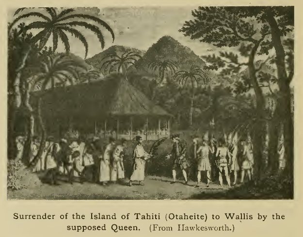
Surrender of the Island of Tahiti (Otaheite) to Wallis by
the supposed Queen. (From Hawkesworth.)
Passing in sight of Eimeo, Moörea, or Duke of York's Island, the Dolphin held a nearly west course till about 175° W., when, like Byron, Wallis steered for Tinian. Only a few small islands were sighted en route, among them Uea or Wallis to the north of the Tonga group, and Rongelap in the northern part of the Marshall Islands of modern maps. At Tinian refreshments were obtained in the form of beef (procured by hunting the almost wild cattle), pork, and fruits of various kinds, including limes, by means of which the sick were greatly benefited. Observations for latitude and longitude were taken, those for longitude giving a result within two or three miles of the true position. The rest of the voyage, made by the usual route, calls for no detailed description. At Batavia, where a vain attempt was made to procure anchors and cables, many of the men fell sick, and it was not till they had been landed at the Cape (reached on February 4, 1768) that their health was re-established. Frequent astronomical observations were again made here, the longitude obtained being 18° 8' E., or about 4 less than it is in reality. Finally, on May 20, the Dolphin arrived in the Downs, 637 days, or the best part of two years, from the date on which she sailed out of Plymouth Sound.
The route followed by Carteret in the Swallow lay on the whole to the south of that of Wallis, but not far enough in this direction to throw much additional light on the important groups, hitherto but slightly known from the voyages of Quiros and Tasman, lying in the Western Pacific to the south of 10° S. Important discoveries were made, but not until the confines of the Australasian region in the neighbourhood of New Guinea were reached. After taking in water during stormy weather at Masafuera, Carteret sailed west in about 28° S.—a course which Wallis had found impossible—searching in vain for the islands of St Ambrose and St Felix laid down to the west or north-west of Juan Fernandez in some of the charts and works of navigation of the time. He also sailed across the supposed position of Davis Land without finding it, and only when 130° W. had been reached was land discovered in the form of the small isolated Pitcairn Island (so named from the youth who first sighted it) to the south of the Low Archipelago. Gales and dark cold weather had been experienced, and, as in Wallis's case, it was found impossible to keep in a high southern latitude. The ship, however, took a course to the south of Tahiti, and only one or two of the small isles in this direction were sighted. One of these received the name Osnaburgh, already given by Wallis to a more northerly one. The ravages of scurvy made it necessary, for the sake of procuring refreshments, to still further diminish the latitude, hopes of discovering continental land to the south being for the present abandoned. Carteret was surprised at finding no trace of the Solomon Islands, which, misled by the erroneous maps then current, he expected to find east of 177° W. Early in August the current was for the first time observed to set to the south, and he deduced therefrom the existence of a passage between New Zealand and New Holland. On August 12, 1767, the Santa Cruz group (named by Carteret Queen Charlotte's Islands) was reached. Although discovered by Mendaña a century before, and the scene of that navigator's death, the position of the group had been very imperfectly known, and Carteret may be credited with its re-discovery. The largest island—Santa Cruz—he named Lord Egmont's Island, or New Guernsey. Hostilities occurred here, and the master and others were wounded. The voyage was continued to the north of the main islands of the Solomon group, but, a current having set the ship to the southward, Gower was sighted on the 20th, and Malaita (named Carteret) on the 21st. The former was afterwards visited, and coconuts were obtained from a body of natives with whom some hostilities took place. The next land seen was the "Nine Islands" (since known as the Carteret group), which Carteret wrongly identified with the Ontong Java of Tasman. After passing between the Green Islands and Buka, which were named respectively Sir Charles Hardy and Winchelsea, the south point of New Ireland was sighted.
Carteret's most important discovery now awaited him. The strait between New Ireland and New Britain, it will be remembered, had been taken by Dampier for a deep bay only (St George's Bay). But when, after refreshing in a sheltered cove just within the supposed bay (described as much the best that had been met with since leaving the Strait of Magellan), Carteret attempted to continue his voyage by the route followed by Dampier, he found himself carried to the north-west into a deep gulf, which proved to be a strait between two separate islands. The channel, which was divided in two by an island (Duke of York's Island), received the name St George's Channel, and the land to the east that of New Ireland—the old name, New Britain, being kept for the more westerly land. At the northern extremity of the latter land were sighted the remarkable peaks, still known by the names given them by Carteret, the Mother and Daughters. A strong westerly current carried the ship along the inner coast of New Ireland, and between this and the populous Sandwich Island, with whose black woolly-headed inhabitants some intercourse was held. The name New Hanover was bestowed on the high tree-covered island which continues the trend of New Ireland to the north-west, and that of Byron Strait on the intervening channel. The passage thus effected, involuntarily in the first instance, proved to be much better and shorter than that outside the islands. The Captain, however, was much dispirited by sickness—so much so as to be almost ready to sink under the arduous duties devolving upon him.

Carteret's Discoveries east of New Guinea. (From the chart
in Hawkesworth's Collection.)
(Note. The darker outlines are those of coasts discovered
by Carteret.)
Click on the map to enlarge it.
The further voyage led past the south side of the Admiralty Islands—the name bestowed by Carteret, though the group had been discovered in 1616 by Schouten and Le Maire—where hostilities with the unfriendly natives occurred. The small islands of Durour and Matty, the latter named after a friend of Carteret, were afterwards discovered. Friendly intercourse was held with the inhabitants of Pegan or Free Will—the latter name being given from the readiness with which one of the natives accompanied the voyagers—and Carteret then sailed on a N.W. by N. course, which took him north of the equator. After one or two other small islands had been passed, the island of Mindanao was reached on October 26. The southern coast of this island was examined, but no refreshments being procurable a course was laid for Celebes, where, after some difficulty, supplies were obtained at Bonthein in the southern extremity of the island. Batavia was reached on June 3, 1768, and the Cape on November 28. The Swallow finally anchored at Spithead on March 20, 1769, having, soon after leaving Ascension, met with the French navigator Bougainville, then also returning from his voyage of circumnavigation.
It was but a few months after the last two of these British expeditions set out, and while both were still absent, that Louis Antoine de Bougainville, the first of the great French circumnavigators, though not the first seaman of his nation to complete a voyage round the world, embarked on an undertaking very similar to theirs, and one which took him over a route in the main corresponding with those of the English voyagers. Destined for the law by his parents and educated at the University of Paris, Bougainville felt himself drawn instead to the military profession, albeit fond of scientific studies and author of a treatise on the integral calculus. He took part in the campaign in Canada which ended so disastrously for the French power in North America, and after the conclusion of the Treaty of Paris entered on a naval career, though he still retained his military rank. At his suggestion, the project for the colonisation of the Malouines or Falkland Islands was undertaken in 1763, and on September 15 of that year he sailed for those parts with the Aigle and Sphinx, repeating the voyage, with supplies for the colonists, in 1765. But the rival claims of the English and Spaniards soon caused the enterprise to be abandoned, and on December 5, 1766, he sailed south, for the third time, in the frigate La Boudeuse, charged with the commission of ceding the settlement to Spain, and continuing his way across the Pacific. The second in command of this famous expedition, to which in 1767 was attached the store-ship Étoile, was Duclos Guyot. On the outward voyage Bougainville examined the Salvages, dangerous rocks between Madeira and the Canaries, and visited Rio de Janeiro and the estuary of the La Plata, whence, on November 14, 1767, he finally sailed from Montevideo for the Strait of Magellan. After the usual experiences in the strait, he entered the South Sea at the end of January, 1768. Two months later he sighted various islands of the Tuamotu group, which he named Dangerous Archipelago. Early in April the ships anchored off the coast of Tahiti, discovered by Wall is eight months before, one of its high peaks receiving the name Le Boudoir or Peak of La Boudeuse. The luxuriant aspect of nature in this island struck the navigators with delight, while the mild and peaceful disposition of the inhabitants, contrasting strongly with those of some of the other Pacific groups, accorded well with their surroundings. The reception given to the French was a most cordial one, and though the intercourse was for a time marred by the murder of several of the islanders by the sailors, friendly relations were again established. Bougainville waited, however, only until the necessary supplies of wood and water had been obtained and the health of the sick somewhat re-established to continue the voyage. To the group of which Tahiti formed one unit he gave the name Bomba Archipelago, though this soon gave place to Cook's designation, the Society Islands.
Continuing the voyage early in May, 1768, Bougainville next discovered several islands of the Samoa group, to which he gave the name Navigators' Islands, which, concurrently with the native name, it still bears. The absence of roadsteads prevented him from landing, though some intercourse was maintained with the people, who showed little of the good faith and confiding disposition, and little too of the artistic skill, of the Tahitians. Still less pleasing were the inhabitants of the next islands visited—certain of the New Hebrides, called by Bougainville the Grand Cyclades—a collision with whom took place during an attempt to obtain refreshments. The inhabitants were of the thick-lipped black type common to the islands of this part of the Pacific, from which it has gained the name "Melanesia." An outbreak of scurvy had now assumed serious proportions, and as the food supplies were running short much distress was experienced.
In spite of his wish to verify his belief that he had reached the "Austrialia del Espiritu Santo" of Quiros, the commander found himself compelled to continue his westerly course in order to reach the Moluccas as soon as possible. But in so doing he continued to make discoveries, soon becoming entangled among the islands and channels lying off the eastern extremity of New Guinea, among which he had to submit to an enforced detention. To the gulf in which he found himself he gave the name Louisiade, which has since been applied to the whole archipelago. On at last finding a passage round the cape named by him Cape Deliverance, he sighted further islands not previously visited, and passed through the strait since known by his name, touching at Choiseul in the Solomon group. Hostilities with the cannibal natives ensued, and the river, which was the scene of attack, was called Rivière des Guerriers, the island receiving the name which it has since retained. Bougainville and Buka Islands, in the same group, were next sighted, the latter name being a word constantly repeated by the natives during their intercourse with the French. The winds and currents then made it necessary to continue the voyage to New Britain. Coming to anchor in a supposed bay near the east end of that island, the navigator found traces of the recent visit of Carteret, who, as already related, had proved that a wide strait separated New Britain from New Ireland. The stopping place was named by Bougainville Port Praslin. No supplies being obtainable, famine stared the navigators in the face as they continued their voyage to the north-west, and matters grew worse as time went on. The islands named by Bougainville Île des Anachorètes and Échiquier were sighted, as also the coast of New Guinea, the end of which island was rounded. Finally, after approaching Ceram to no purpose, refreshment was at last found at Kajeli in Buru, whence the ships made their way to Batavia. Here, as far as geographical discovery was concerned, the voyage was over, the return being made by Mauritius and the Cape to Ascension, the Boudeuse finally casting anchor at St Malo on March 16, 1769, after an absence of two and a half years. The Étoile returned later, having been left behind at Mauritius to refit.
This voyage of circumnavigation was one of the first in which the interests of science were provided for by the inclusion, among the staff, of scientific experts, namely the botanist Commerçon and the astronomer Verra, both of whom stayed at Mauritius on the homeward voyage to complete their work. The example thus set was followed throughout a long series of important voyages, French and English, the results of which were proportionately enhanced in value.
This is perhaps the most suitable place in which to refer to one or two voyages made about this time to the eastern parts of the Malayo-Papuan Archipelago, though being more or less isolated undertakings they do not quite fall into line with the other voyages dealt with in this chapter. As just stated, the botanist Commerçon, of Bougainville's expedition, had remained behind at Mauritius for further research in that region, and in the execution of this task he had the aid of a French official of the marine department, Pierre Sonnerat, who was presently to make himself a name for natural history researches of his own. An expedition was soon afterwards fitted out at Mauritius under the Chevalier de Coetivi, having among its objects an examination of the products of the Eastern Archipelago, especially the Philippines and the islands to the south-east of them. A start was made on June 29, 1771, Sonnerat sailing with Coetivi in the Isle de France, which was accompanied by the corvette Nécessaire. The voyage resulted in valuable additions to the knowledge of the zoology and botany of the region visited, which included some of the western outliers of the Papuan islands, though the mainland of New Guinea itself was not visited. In 1766 Sonnerat published a narrative of the voyage under the somewhat misleading title Voyage à la Nouvelle Guinée. The small island of Coetivi, in the Indian Ocean south of the Seychelles group, was discovered and named during the outward voyage.
Shortly after this an English voyage to the same part of the Eastern seas was carried out by Captain Thomas Forrest, on behalf of the East India Company. The Company had at this time an establishment at Balambangan, a small island off the northern end of Borneo, and as the authorities here received reports of the occurrence of nutmegs and other spices in Western New Guinea, outside the Dutch jurisdiction, Forrest offered to undertake a voyage thither to ascertain whether a profitable trade in these commodities could be opened. Sailing in November, 1774, in the Tartar galley, a prau or native craft of ten tons burden, he visited the Moluccas, and eventually, in 1775, reached Dorey harbour, on the north coast of Western New Guinea.[1] He spent some time in an examination of the neighbourhood, and after much search the nutmeg tree was found growing wild. But the hopes of establishing a trade were not realised, and Forrest returned to the English factory in Borneo, which he reached, after some stay in Mindanao and other islands en route, in February, 1776.[2] Forrest published an interesting account of the voyage in 1780.
[1 This locality became noteworthy in more recent times from the visit paid to it by the naturalist-traveller Alfred Russel Wallace.]
[2 Balambangan had by this time been evacuated.]
The interest in Pacific discovery was now thoroughly aroused, and expeditions followed each other so fast that two if not three were sometimes in the field in one and the same year. Even before the return of Wallis, and while both Carteret and Bougainville were still at the opposite side of the globe, preparations were already on foot for a new British voyage, which was to usher in a period of more rapid progress than had been seen since—more than a century earlier—Tasman's voyage brought to a close the great discoveries of the sixteenth and early seventeenth centuries. The immediate inducement to the voyage was not purely geographical, being supplied by the calculation of astronomers that a passage of the planet Venus across the sun's disc would take place in 1769, and that the transit could best be observed in some part or other of the Pacific Ocean. The Royal Society was foremost in urging on the Government the desirability of despatching an expedition to that region, to be accompanied by a competent astronomical observer, and its representations proved successful. But geographical research was not left out of sight by the promoters. Among the Fellows of the Royal Society at the time was Alexander Dalrymple, an enthusiastic believer in the existence of a great Southern Continent, who by his writings did much to bring the question before the public, and who, being well versed also in astronomy, was at first selected to take charge of the observations, though his refusal to serve in a position subordinate to a naval officer made it necessary to arrange otherwise. The choice of commander fell on Lieutenant James Cook, and proved in every respect a most fortunate one. In his three voyages of discovery, occupying the greater part of ten years. Cook showed himself the most successful navigator produced by this or probably any other country, the extent of unknown seas traversed rendering those years one of the decisive turning points in the progress of geographical discovery.
The son of a Yorkshire farm-labourer, Cook's passion for the sea was first gratified at the age of eighteen. After passing some years in the merchant service with credit, he entered the royal navy on the outbreak of war in 1755, and did important service in Canadian waters under Captain (afterwards Sir Hugh) Palliser, afterwards carrying out valuable surveys in the same quarter of the globe. He had but lately returned when the preparations for the proposed expedition were set on foot, and he was appointed to command the Endeavour, a stout Whitby ship built for the coal trade, but chosen for the voyage by Sir Hugh Palliser. An astronomical observer was found in the person of Mr Charles Green, assistant to the Astronomer Royal, while permission was given to Mr (afterwards Sir Joseph) Banks, who had lately been elected an F.R.S., to accompany the expedition, with his friend Dr Solander and several assistants, for the purpose of making researches in natural history. The association of such a competent scientific observer with the commander was of the utmost advantage, and to Banks's enthusiasm and loyal co-operation a large part of the success of the expedition was due. A further point of superiority in this over previous similar undertakings, consisted in the measures taken to combat the dreaded scurvy—which so often played havoc with the crews of ships engaged in lengthened voyages—by the supply of lime-juice and other remedies.
The Endeavour sailed from Deptford on July 30, 1768, and in the following January successfully doubled Cape Horn without experiencing any of the storms for which that region is famous.[1] While in its neighbourhood a serious misadventure befel a party which had gone inland to examine the country and was forced to camp out during a night of such piercing cold that two Negro servants of Mr Banks succumbed. The charts of this region proved very incorrect, and the surveys effected were thus of much value. The voyage to Tahiti, which from the experience gained during Wallis's voyage had been chosen as the locality in which to observe the Transit, passed without important incidents, only a few small islands being sighted en route. On April 13 the Endeavour entered Port Royal Harbour, and intercourse with the natives was quickly established. During the three months' stay, thanks to the strict discipline maintained by Cook, the relations with the people were on the whole thoroughly friendly, although their pilfering habits once or twice threatened difficulties. The Transit was successfully observed at two or three different localities, and excursions inland and along the coast to the eastward of the main station added to the explorers' knowledge of the island. On leaving, a native named Tupia was taken on board at his own desire, and proved of much service during the further course of the voyage. From the point of view of geography, the chief interest was now only beginning, for a serious attempt was to be made to solve the problems presented by the unknown area in the south-west of the Pacific Ocean, which had baffled the efforts of so many previous voyagers. With the exception of Tasman in his famous voyage of 1642, none of the navigators who had traversed the Southern Pacific during the previous centuries had passed to the south of 30° between 100° west of Greenwich and the coasts of New Holland, so that a vast virgin field lay open to the voyagers in the Endeavour when they set out in 1768. Even on the route from Cape Horn to Tahiti Cook had followed a more southerly course than his predecessors, and so had pushed outward the possible limits of land in this direction. But the results after leaving Tahiti were to be still more important. Cook first visited several of the other islands lying to the west of Tahiti, giving to the whole group the name of Society Islands, after the scientific body which had inspired the voyage. He then boldly steered for the unknown south, discovering on the way the small island of Rurutu, in the Austral group (spoken of by Tupia as Oheteroa), but seeing no other land until, on September 1, the furthest south was reached in a little south of 40°. Birds, however, were seen, sometimes in great numbers.
[1 A chart showing Cook's routes on his three expeditions is given opposite p. 254. It has been based, by permission, on the chart (on a larger scale) given by Mr Kitson in his recent work, Captain James Cook, the "Circumnavigator."]
A more or less westerly course was now sailed, and on October 8, 1769, the coast of New Zealand—hitherto visited only by Tasman, in 1642—was struck between latitudes 38° and 39° S. It formed white chalk-like cliffs on either side of an open bay, with low land between, backed by ranges of mountains. This locality, which was named Poverty Bay, lay in about 38° 40' S. on the east side of the North Island—the side opposite to that visited by Tasman. After sailing southwards past Hawke's Bay to a point named Cape Turnagain, the ship's head was put in the opposite direction, and the coast followed north of Poverty Bay, communication being frequently opened with the natives, who were in general friendly, though one or two hostile collisions occurred. As usual, they showed thieving propensities, and proofs were more than once seen of their cannibalism. Mr Banks and Dr Solander constantly added to their botanical collections, and a transit of Mercury was successfully observed by Mr Green. After reaching the most northern point, the Endeavour turned south and followed down the west side of the North Island, afterwards passing through Cook Strait and so definitely proving the division of the main body of New Zealand into two distinct islands. Valuable observations of the country and people were made. The latter on the west coast were frequently found dwelling in forts placed in strong situations and called Hippahs. Cape Turnagain having been once more sighted, the ship's head was put south and the circuit of the South Island made in the reverse direction from that in which the North had been circumnavigated. Few incidents of importance occurred, no native being seen during the whole passage. The track led round the south end of Stewart Island (the insular character of which was not discovered), and during the voyage up the west coast the great snowy range of the New Zealand Alps was kept constantly in sight. Reaching Cape Farewell and once more entering the mouth of Cook Strait, the navigators disproved once for all the idea that New Zealand formed part of a great continental mass. Such might nevertheless exist more to the south, and, had the condition of the ship permitted, an attempt would have been made to solve this question by taking the Cape Horn route and keeping in high southern latitudes. This was felt to be impossible. Still, as provisions for six months yet remained, it was determined to attempt further geographical work by steering westward for the east coast of New Holland, then quite unknown, and following it northward as far as possible. Apart from the question of the Southern Continent, this was undoubtedly the most important piece of geographical work remaining to be done, and its successful accomplishment, after so long a time had been already spent on the voyage, bears witness to the keenness for discovery animating the navigators. In the end they were put to some straits before reaching a port at which they could renew their supplies, the length of time during which fresh provisions had been scarce causing some of the crew, as well as the Tahitian Tupia, to be attacked by scurvy.
The Endeavour sailed from Cape Farewell on March 31, 1770, and on April 19, after premonitory signs had been noticed during several days, land was sighted by the first lieutenant, Mr Hicks, a prominent point receiving his name in consequence. This was a little south of 37° on the coast of New South Wales. By thus making the first authentic discovery on this side of the great island Cook achieved a success which was destined in time to decide the fortunes of the whole of Australia. Landings were soon made and natives encountered, but it was with difficulty that they were induced to put aside their suspicions. At one place the botanical labours of Banks and Solander met with such a rich reward that the bay there formed between two green headlands received the name of Botany Bay, which it has ever since borne. Soon afterwards, on May 6, Port Jackson, the site of the future city of Sydney, was discovered and named. The voyagers were now approaching a region exceedingly dangerous by reason of the shoals and coral reefs, which there attain an extent unsurpassed in any part of the globe. The utmost vigilance was therefore necessary. Passing Cleveland Bay, Rockingham Bay, Trinity Bay, and other coast features which still bear the names then assigned them, the voyagers used every opportunity of observing the nature of the country inland. On the 10th a disaster befel them which, but for the utmost good fortune, might well have proved fatal to the whole crew. After successfully passing some dangerous shoals and reaching, as it seemed, deeper water, the Endeavour, with hardly any warning, struck on an invisible rock and remained immoveable at a distance of eight leagues from land, which, even were it possible to reach it, could not afford more than temporary sustenance to so large a body of men.[1] All depended on the chance of saving the ship, and the amount of damage caused by the sharp coral rock rendered such chance extremely slight. The men worked incessantly at the pumps, and by throwing overboard everything that could possibly be spared, the ship was at length so far lightened as to float at the second high tide after striking. That she did not now sink was due only to the happy chance that the largest hole had been plugged by a portion of the rock remaining fixed within it. By passing an old sail covered with wool and oakum under the damaged portion of the hull, the leak was further checked, and it became possible to navigate the vessel to a sheltered harbour which was found not far off, within the mouth of the Endeavour River (still so named). Here the ship was brought to the shore, and by hard work the damage to her bottom was at last repaired. During the stay the country inland was examined, and the kangaroo, the largest Australian mammal, was here for the first time seen and secured.
[1 The point of land abreast of the reef on which the ship struck received the name Cape Tribulation, in reference to the misfortune experienced.]

Cook's chart of the East coast of Australia. (Outline
sketch.)
Click on the map to enlarge it.
The voyage was resumed on August 4, and the intricate and difficult navigation through the reefs which fringe the coast was successfully accomplished, though the ship was again more than once in a position of great danger. Cape York, the northern extremity of the north-east peninsula, was reached on the 21st, and by sailing between this and the islands to the north, Cook demonstrated once more the separation of New Guinea from New Holland—a fact which had been proved by the voyage of Torres more than a century and a half before, but was not a matter of general knowledge at the time. The name Endeavour Strait was given to the channel nearest the mainland, through which the ship sailed. Having passed through this, Cook steered north for the almost unknown south coast of New Guinea; but the shallowness of the sea off the latter, and the uncertain character of the inhabitants, made it impossible to do much towards its examination. On landing, Mr Banks found the vegetation, though luxuriant in growth, by no means rich in species. The natives that were seen assumed a threatening attitude: as had been observed by Tasman long before, they made use of fire to throw at their enemies for the purpose of blinding them, though without much effect. Continuing the voyage, the navigators passed Timor and Rotti, and reached the small island of Savu, where was a Dutch resident and where with some difficulty they obtained fresh provisions for the sick. Thence the Endeavour sailed for Batavia, where extensive repairs were found necessary, and during the delay thus occasioned many of the officers and crew fell ill with fevers and other ailments, to which both Tupia and his boy Tayeto succumbed. On December 27, 1770, the Endeavour sailed from Batavia, and after a ten days' stay at Prince's Island, steered for the Cape. There was now more sickness than at any other time throughout the voyage, and deaths occurred frequently, Mr Green the astronomer and Mr Parkinson, who had accompanied Mr Banks as draughtsman, being among the victims. After a month's stay at the Cape, in March and April, the voyage was continued, and after touching at St Helena en route the Endeavour cast anchor in the Downs on May 12, 1771, having been absent a little over two years and nine months.
Fruitful as this voyage had been—for, besides proving that no continental land occupied any part of the south-western Pacific north of 40° S., Cook had for the first time circumnavigated New Zealand, and explored almost the whole of the eastern coast of Australia—it was only the beginning of a long series of equally important discoveries. Recognising the unusual qualifications of the commander, which consisted not only in his zeal for discovery but also in the excellent discipline he maintained and the constant care he evinced for the welfare of his crew, the Government at once decided to send him out again, this time with the sole object of geographical discovery. Although on the former voyage he had proved that no continental land existed in the Southern Pacific between Tahiti and New Zealand, there still remained a vast area encircling the South Pole and reaching in many parts as far north as 40°, which was still absolutely unknown, and which might contain a continent rivalling in extent those of the known world. To throw light on this great unknown area was the primary object of the new voyage, and we shall see that it met with a degree of success which cast into the shade all previous efforts in this direction. Two practically new ships, built like the Endeavour at Whitby, with a tonnage of 462 and 336 tons respectively, were purchased; the larger, the Resolution, being placed under Cook's own command, while the command of the smaller, the Adventure, was given to Tobias Furneaux, who had done good service under Wallis as second lieutenant. Banks, who had so large a share in the success of the former voyage, seems to have entertained the idea of once more accompanying the commander, but it was not carried out. Instead, a naturalist of German extraction, Johann Reinhold Forster, was chosen to go in that capacity, and was accompanied by his son. Immense pains were taken in the fitting out of the expedition, which was probably better equipped than any previous one had been. The ships were ready by the middle of 1772, and left Plymouth on July 13. In the instructions given to him, dated June 25, Cook was directed to proceed to the Cape, and after refreshing there to apply himself first to the search for land in the almost untraversed ocean to the south. It will be remembered that early in the century the French navigator, Lozier Bouvet, had sighted land in this region and given to it the name Cape Circumcision. The search fox this land had just now been taken up in France, and it is necessary to speak of one or two French voyages before following Cook in his new undertaking.
Ives Joseph de Kerguelen-Trémarec, an enterprising navigator, though a man of somewhat imperious temper, had prevailed on the Government to despatch him on the quest above referred to. He had sailed in 1771, and returned to France in the very month in which Cook sailed on his second voyage. From Mauritius he had sailed south in January, 1772, and in February had discovered the island which has ever since borne the name Kerguelen Land—the largest of the scattered islands in the Southern Indian Ocean. Though in reality one of the most dreary and inhospitable spots on the surface of the globe, Kerguelen had formed the most extravagant ideas of its value, and, as he had seen but a part of the island, he imagined it to be merely an advanced outpost of the long-sought southern continent. Being sent out again in 1773 to make further examination of this supposed south land, he realised the mistake he had made, and gave to the land he had discovered the appropriate title, Land of Desolation.
Meanwhile another enterprising French navigator, Marion-Dufresne, with Crozet as second in command, had undertaken a somewhat similar voyage. On his return to France Bougainville had brought with him a young native of Tahiti, whom it was necessary to take back to his home, and Marion, eager to distinguish himself by geographical discovery, volunteered for the task, offering to provide one ship and to bear the expenses of another. The young Tahitian had been sent to Mauritius, and Marion sailed thence in October, 1771. His charge was, however, attacked by smallpox at the isle of Réunion and died, so that it became possible at once to undertake the search for new lands. His own vessel was named the Mascareigne, while the second ship, the Marquis de Castries, was commanded by the Chevalier Duclesmeur. After visiting the Cape, Marion sailed south at the close of 1771, or before Kerguelen had effected his discovery, the early part of his voyage having been devoted to the more northern parts of the Indian Ocean. On January 13, 1772, Marion discovered a snow-clad mountainous land in 46° 45' S., and, like so many others in like case, flattered himself that it was part of the supposed southern continent. It consisted, however, merely of two small islands, with other islets near them, being identical with the group afterwards named Prince Edward Islands by Cook. The larger and more southern was named by Marion Terre d'Espérance, while the more northern received the name Île de la Caverne. The former is now known, from its discoverer, as Marion Island. This land was not identical with that seen by Bouvet, as its latitude was less, while it lay a long way to the east of the longitude assigned by that navigator, though even this eventually proved to have been too easterly. Fearing to become entangled in the ice if he went further south, Marion steered east, and sighted the group now known as the Crozet Islands on January 22-23. He ordered Crozet to land on the largest and take possession in the name of the King of France, a circumstance from which it still bears the name Possession Island. It supported neither tree nor shrub, but rose into high snow-clad peaks. The search for the continent was now abandoned, and the ships steered for Van Diem en's Land, which had not been touched at since discovered by Tasman in 1642. Here difficulties arose with the natives, and the ships sailed for New Zealand. Friendly intercourse with the natives was there maintained for some time, but it ended in a catastrophe, the commander and some sixteen others being murdered during a visit to a chief on the shores of Cook's Bay of Islands. Crozet and Duclesmeur therefore sailed away for the islands of St Paul and Amsterdam, the remainder of the voyage yielding no result in the way of discoveries.
We must now return to Cook and his comrades, who, after touching at Madeira and the Cape Verdes, sighted land in the vicinity of Table Bay on September 29. The Dutch authorities obligingly gave the necessary facilities for making up their supplies, and on November 22 the southward voyage was commenced, warm clothing being distributed in view of the meditated approach to the cold and stormy regions in this direction.
Difficulties soon began, a violent gale driving the ships to the eastward, while, after the winds moderated, they were frequently in danger from fog and ice, the first iceberg being seen on December 10. Arrived at the latitude in which Cape Circumcision had been placed by Bouvet, a keen look-out was kept for land, for although they were some degrees to the east of the assigned longitude, the idea that the cape formed but the most prominent point of a larger mass encouraged the expectation that such land might be found to extend some distance to the east. No land was, however, sighted, and the constant fog, rain, and snow made navigation dangerous in a sea encumbered with ice. An attempt to go west proved unsuccessful, but on sailing south the Antarctic Circle was crossed, for the first time in the history of Man, on January 17, 1773. This alone would have been an achievement sufficient to make the voyage memorable, and it clearly proved that the ocean extended, in this quarter of the globe at least, far to the south of the position in which land had hitherto been imagined to exist. Although the sea was fairly open, Cook thought it unwise to venture beyond 67° 15', but determined to sail east for the lands discovered by Marion-Dufresne and Kerguelen, of which he had had tidings while at the Cape. On February 4 those in the Resolution had the misfortune to part company with the Adventure during a dense fog, and every effort to regain sight of her was unavailing. It was decided to sail for New Zealand, which had been named as a rendezvous in case of separation. It was reached without accident on March 26, on which day they entered Dusky Bay, near the south-west extremity. Some time was spent here examining the shores of the bay and the forest-covered country behind it, intercourse being opened with the natives. Sailing north on May 4, they entered Queen Charlotte's Sound, and soon saw the Adventure at anchor. After the separation Captain Furneaux had been prevented by a severe storm from returning to the spot where the Resolution had been last seen, and after cruising about for some time made sail for Van Diemen's Land, where he hoped to effect some repairs before making for the rendezvous in New Zealand. On March 11, the Adventure came to anchor in an excellent harbour, but, on sailing with a view to testing the continuity of Van Diemen's Land with New Holland, encountered a gale which thwarted this purpose. Furneaux went north along the east coast, and, passing near the end of this, sighted the islands in the south of Bass Strait since known by his name. He seems to have been by this time convinced that no strait existed here; so, turning east, he steered for New Zealand, arriving in Queen Charlotte's Sound early in April. The natives, who before Cook's arrival seem to have meditated an attempt to get possession of the Adventure, subsequently became friendly. and Cook planted a garden with European vegetables for their benefit. The voyage was resumed on June 7, the first task undertaken being the search for the southern continent to the east of New Zealand.
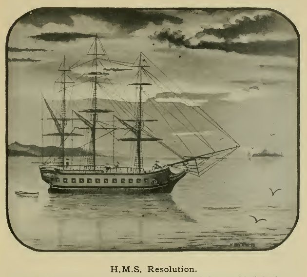
H.M.S. Resolution.
(From a drawing in the possession of the Royal Geographical
Society.)
By enforcing the use of wild celery and scurvy grass, Cook kept the crew of the Resolution in good health, but scurvy prevailed for a time on board the Adventure. No land being found between New Zealand and 133° W., the ships turned north, and after passing near Pitcairn Island and crossing 20° S., steered for Tahiti, which was reached on August 16, 1773. A good many changes had taken place since the Endeavour left the island in 1769. The voyagers, however, were again well received and visited various parts of the coast; but finding it difficult to obtain the needed supplies, they sailed on September 2 for Huahine. Here Cook saw again his old friend Oree, and obtained a large number of pigs, afterwards passing over to Ulietea, and thence sailing west for the islands discovered by Tasman in 1643 and named by him Middelburg and Amsterdam. During the voyage thither the Hervey Islands were discovered, on September 23, 1773. The native name's of Tasman's islands were found to be Eua and Tongatabu, the latter being the largest of the group known as Tonga, and by Cook designated the Friendly Islands, from the harmony that seemed to reign among the natives and their courteous reception of their visitors. Their double canoes were much admired for their workmanship and sailing qualities.
Before resuming his exploration of the ocean to the south, Cook decided to return to New Zealand for wood and water, as also for the purpose of visiting the natives on the east coast of the North Island. On October 21 they reached the neighbourhood of Cape Kidnappers, and, having left with the natives some of the pigs, seeds, etc., they had on board, sailed south, but, encountering stormy weather, lost sight of the Adventure on the 30th. They made their way through Cook Strait to Queen Charlotte Sound, but having searched the whole of this part of the coast without finding a trace of their consort, and repaired the ship as far as possible, they sailed for further exploration on November 25, steering this time more south than east, and thus extending their search for land into latitudes never before approached on this side of the globe. On December 14 islands of ice were seen, and for the next six weeks antarctic conditions of sea and weather prevailed, the Antarctic Circle being twice crossed, in the neighbourhood of 140° W. and 106° W. respectively. In the latter longitude the parallel of 70° S. was crossed for the first time in the world's history, and on January 30, 1774, they reached the edge of the solid ice-field, rising into ridges like ranges of mountains. To have attempted to push farther south would have been a rash undertaking, and Cook resolved to go north, having ascertained beyond a doubt that no continent existed unless far to the south.

The Resolution among Icebergs.
(From the narrative of Cook's Second Voyage.)
Instead, however, of returning at once to the islands already visited, he steered somewhat east of north, and on again turning west the first land reached was the small Easter Island in the Eastern Pacific. During the passage thither Cook became seriously ill, and had only partially recovered when the island was reached on March 11. After endeavouring, without much success, to obtain fresh provisions, and examining the gigantic statues for which the island is famous, the voyagers returned west, touching at Hiwaoa of the Marquesas group (La Dominica of the Spanish discoverers) and afterwards at Tiokea (Takaroa), discovered by Byron in 1765, before reaching Tahiti. During their stay here they had a sight of an imposing fleet of war canoes and transports which had been got together to operate against the island of Eimeo, the aggregate of the crews being estimated at over 7000 men. Here, as well as at Huahine and Ulietea, they met with the usual hospitable reception, and, sailing from the last-named, left behind the native Oedidee, who had been with them since their visit to the group in 1773. Steering nearly due west, they sighted, on June 16, an atoll composed of several rocky islets, and named it Palmerston, after one of the Lords of the Admiralty. Niue, to the south of the Samoa group, was next reached, and named Savage Island, from the character of the inhabitants. They then proceeded to Namuka (Rotterdam of Tasman) to procure water and fresh fruits, and on leaving this sighted the volcanic peak of the island of Tiafu (Amatafu), guessing at its character from its appearance. Cook next visited the important group lying west of the Fiji Islands, which has ever since retained the name bestowed by him on this occasion—the New Hebrides. Its northern portion had been discovered by Quiros over a century and a half previously, but the southern islands were quite unknown until visited by Cook. The first islands he touched at were in the north—Lepers', Aurora, and Whitsuntide or Pentecost; but, leaving these, he anchored in a harbour on the north-east side of Mallicolo, which he named after the Earl of Sandwich. Steering south, he sighted in turn the volcanic islands of Ambrym; Api, and a small island near it; and Efat (which he also named Sandwich). At the last of these some hostilities occurred, and no long stay was made. The people seemed to be of a different race from those of Mallicolo, and spoke a different language. Sailing on, the voyagers passed the island of Erromango, and soon afterwards sighted a volcano pouring forth fire and smoke, which proved to be on the island of Tanna, which was accordingly visited. Showing suspicion at first, the natives became in time more friendly, and some attempt was made to examine the geography of the island. A party made its way for some distance inland in the hope of getting a nearer view of the volcano, which continued to show activity, but the broken nature of the ground and the thickness of the woods forced them to desist.
Cook had now explored almost the whole of the group—one of the most important for the number and size of its islands in the whole of the Western Pacific, though, owing to international rivalries, it has been the last of all to be brought under definite European control. But before leaving it, he returned up the west side of the several islands and surveyed the coasts of the largest and longest-known island, the Tierra del Espiritu Santo of Quiros. Leaving this on August 31, he sailed south-west, and was rewarded by the discovery of the largest of the Pacific islands proper, which was struck near its north-west end. Here a landing was effected and friendly relations established with the natives. An eclipse of the sun was observed and a portion of the coast surveyed, while a party pushed some little distance among the hills and obtained a view across the island. No native name could be found for it as a whole, and Cook therefore bestowed upon it that of New Caledonia, which it bears to this day. Off its south-east end he made the circuit of the Isle of Pines, and landed on a small island which he named Botany Island, from the interest its vegetation afforded to the botanists who accompanied him.
It was now time to think of commencing the homeward voyage, but before doing this Cook once more put the ship's head for New Zealand, with the purpose of obtaining some refreshment before launching out on the watery expanse of the Southern Pacific. For, not content with his previous work in these high latitudes, he still proposed, instead of taking a frequented route homewards, to prosecute the main object of the voyage by once more crossing a part of the ocean first traversed by the Resolution in the previous year. On the way to New Zealand he made the discovery of a small island lying in the broad ocean and only some five miles in length. It was named Norfolk Island and was found to be covered to a great extent with a large coniferous tree, since generally known as the Norfolk Island pine, though botanically not a true pine. Some of the birds resembled those of New Zealand. Arrived once more at Queen Charlotte Sound, the voyagers found evident signs that the Adventure had been there since their last visit, evidence confirmed also by the natives. On November 10 they once more sailed, steering south-east until about the latitude of Cape Horn, and then keeping on nearly due east until the coast of Tierra del Fuego was reached, on December 17, not far from the western end of the Strait of Magellan. In the whole of this course no land whatever was seen, and the last remaining chance that land of any extent might reach a latitude of from 50° to 60° to the south of the Pacific Ocean thus disappeared. But the indefatigable navigator had not yet done with discovery, for after doubling Cape Horn and passing through Le Maire Strait he continued to steer east, and in about 39° W. came upon one of the bleak and inhospitable lands which mark the approach to the Antarctic region. It was named Isle of Georgia in honour of the King, and bears the name (in the form South Georgia) to this day. The Resolution skirted the north-east coast of this island, which was much cut up with bays and harbours, though rendered inaccessible by ice for the greater part of the year. Continuing towards the south-east through a sea strewn with loose ice and icebergs, Cook sighted still another new land, calling the high promontory which came to view on February 1. Cape Montague, while the group of islands of which it forms a part was named Sandwich Land, the southernmost receiving the name Southern Thule. The easterly course was maintained until February 22, when they had almost reached the longitude in which they had searched for Bouvet's land while on the outward voyage. As therefore it was impossible that any extensive land could exist in this region, the commander at last turned the ship's head north and made his way to the Cape, anchoring in Table Bay on March 21st, after first speaking a Dutch and an English East Indiaman and obtaining news of the Adventure. They learnt that this ship, which had parted company off the coast of New Zealand towards the end of 1773, had reached the Cape twelve months previously by a somewhat similar route across the South Pacific after the crew of one of her boats had been murdered and eaten by the people of New Zealand. During the homeward voyage from the Cape, Cook was still mindful of the cause of geographical science, for on touching at the Azores he stopped long enough to permit of observations for the better determination of the longitude of the group. Finally the Resolution anchored at Spithead on July 30, after an absence from England of a little over three years. The Adventure, which during the voyage across the South Pacific had reached the latitude of 61° S., and had afterwards searched in vain for Bouvet's Cape Circumcision in the South Atlantic, had completed the voyage just over a year earlier, anchoring at Spithead on July 14, 1774.
Thus ended one of the most fruitful voyages of discovery in the whole history of maritime enterprise. Its happy results were in great measure due to the precautions taken to preserve the health of the crews, precautions so successful that only one man had been lost by sickness during the whole three years. It had been possible to return again and again to the task in hand, which was not finally abandoned until the general character of the vast area lying around the South Polar region had been fully demonstrated, while the knowledge of the island groups of the Pacific had been no less materially advanced.
Cook's experiences while battling with the ice of the southern regions had convinced him that any further advance in this direction would be impracticable, and the home authorities were content with what had been already done, making for the time being no attempt to penetrate the mysteries of the Antarctic. But at the opposite or northern extremity of the Pacific there still remained a large region very imperfectly known, although the labours of the Russians, since the beginning of the century, had thrown much light on the relations of Asia and North America, to the latter of which several Russian explorers (including Bering and Chirikof) had penetrated. In 1767 a government expedition under Lieutenant Synd had visited the American coast, and, during the decade immediately preceding Cook's return from his second voyage, hunters were active in the same region. But the results of these enterprises were little known to the outside world, and the British Government, which had already displayed its interest in northern discovery by the despatch of Captain Phipps in 1773 to the sea east of Greenland, considered the geographical problems awaiting solution in the far north-east as worthy of the despatch of a new expedition. Although lately appointed Governor of Greenwich Hospital, Cook once more expressed his readiness to take command. The sloops Resolution and Discovery having been fitted out for the proposed voyage, Cook received his instructions from the Earl of Sandwich and his colleagues of the Admiralty. He once more sailed in the Resolution, while the Discovery was placed under the orders of Captain Charles Clerke, who had been both with Byron and with Cook on his two previous voyages. Lieutenant King, who sailed in the Resolution, undertook the necessary astronomical observations on that ship, while Mr William Bailey was to perform a similar task on board the Discovery. Mr Webber was engaged as draughtsman, and Mr Anderson (surgeon on board the Resolution), who had already taken part in Cook's second voyage, undertook the researches in natural history, as also in matters connected with the manners, customs, and languages of the natives who should be met with. Mr W. Bligh, master of the Resolution, who had already served under Cook in the second voyage, became afterwards known as commander of the ill-fated Bounty. Lieutenant Burney, of the Discovery, subsequently made a name as chronicler of voyages to the Pacific and the far North-east, while one of the midshipmen was Mr G. Vancouver, who lived to command in a subsequent voyage of discovery. Omai, a Society Islander who had been brought to Europe by Furneaux in the second voyage, accompanied the expedition, and proved of great service in dealing with the peoples visited, down to the time when he was finally left behind in his South Sea home. A number of domestic animals were also taken in the hope that they might become established in the countries visited.
On June 25, 1776, Cook sailed from the Nore in the Resolution, finally leaving Plymouth on July 12, the Discovery following on August I. The island of Tahiti was once more chosen as the place of refreshment whence the final start for the northern region should be made, and to reach this destination the route viâ the Cape and New Zealand was again adopted. It is unnecessary to dwell upon the outward voyage, during which, in December, the ships touched land at Adventure Sound, Tasmania, holding some intercourse with the natives, who were found to differ from those seen on the first voyage on the east coast of Australia. The stay here lasted from January 26 to 30, 1777. On the latter date the voyagers sailed for New Zealand, arriving at Queen Charlotte Sound on February 10, and resuming the voyage on the 25th, taking with them two of the natives. Before reaching Tahiti they touched at several hitherto undiscovered islands, besides others previously visited by them. The first touched was known to the natives as Mangea, and at the second Omai found some of his countrymen who had been carried out of their course during a voyage and had arrived there after suffering great hardships. At Watiu (Atiu) as also at the Hervey (since known also as Cook's) Islands, which had been discovered in 1773, the natives were found to speak a tongue closely resembling that of Tahiti, though physically the Hervey islanders recalled the New Zealanders in their fierce and rugged aspect. Diverging somewhat to the north, Cook reached Palmerston (discovered in 1774) on April 13, and spent some time examining the nine or ten low islets of which it is composed. After passing Savage Island (also visited in 1774), he put in at Namuka and thence visited Hapai, as also the islands of the Friendly group which had not before been examined, cordial relations being maintained throughout with the natives. A lengthened stay was made at Tongatabu, where an eclipse was observed on July 5, and soon afterwards final leave was taken of the Friendly Islands, after a total visit of nearly three months.
On August 8, land was again seen and proved to be the island known to its inhabitants as Tubuai, of the group since called the Austral Islands. Tahiti was reached on the 12th, and the experiences of the voyagers during their stay in the neighbourhood of this island were in the main a repetition of those of the former visit. Intelligence was obtained of the recent visit of Spanish ships to Tahiti, but it was ascertained from individuals who had been left behind that they had already taken their departure. Before finally leaving, the remaining domestic animals were landed, and Omai was left at Huahine, where a small house was built for his use, and an inscription with the names of the ships and their commanders cut upon its outside. Cook left the island on November 2, 1777, and, after a month's stay at Ulietea and a shorter stay at Borabora, sailed away to begin the real purpose of the voyage—the examination of the Northern Pacific and the possibility of a route thither viâ the Arctic Ocean. On December 22, the equator was crossed (in 156° 45' W.), and two days later a low-lying atoll with a few clumps of coconuts was discovered in the midst of the ocean. Here an eclipse of the sun was observed on December 30, and the voyage was resumed on January 2, the name Christmas Island having been given to the atoll from the fact that the voyagers had there spent their Christmas. The land next sighted (January 18) was an island belonging to the important Sandwich group, now known by the native name of Hawaii. These islands had almost certainly been visited by the Spaniards in the sixteenth century, but no practical result had ensued, and the group was to all intents and purposes unknown until Cook's visit. In spite of the distance from other Pacific groups the language of the islanders was found to be closely akin to that of Tahiti, so that intercourse could be easily established. Captain Cook stayed some days at Atui (Kauai), the people proving friendly, and made an excursion into the interior. The ships subsequently touched at Niihau, and on February 2 stood away to the north, having laid in a fair supply of fresh provisions and water. Five separate islands had been seen, all lying towards the north-west end of the group, and of these only three, viz. Oahu, Atui (Kauai) and Oneehow (Niihau), were of any size. The group received the name by which it was long afterwards known in honour of the Earl of Sandwich, to whom recourse had already been had more than once as sponsor for new lands discovered by Cook. The natives had made a good impression by their frank and friendly nature as well as by their excellent physique and expertness as swimmers.
On March 7, the north-west coast of North America, here known at the time as New Albion, was reached. An important field for discovery now lay before the voyagers, for this coast from about 40° northwards was perhaps the least known of any of the continental outlines outside the polar regions. Some slight results, it is true, had been attained by the Spaniards, and we may here pause to consider the various efforts made by them, down to 1778, to extend their knowledge of the coast line north of their settlements in Western Mexico.
During the sixteenth century several voyages had been made, the most important being that of Cabrillo and Ferrelo (1542), who reached the outer bay of which the modern bay of San Francisco is an inlet. Early in the seventeenth century Vizcaino had sailed along the coast and claimed to have discovered an excellent port in 37° N., to which he gave the name Monterey. From the date of his voyage (1603), practically nothing further was done for over a century and a half, but in 1768 a movement was set on foot for the resumption of discovery, and it resulted in the despatch of expeditions both in 1769 and 1770 under Don Gaspar de Portola, who in the former year made his way by land to a point not far south of the Golden Gate or entrance to San Francisco Bay, while the southern part of that bay was for the first time examined. The chief result of the expedition of 1770 was the founding of the "Presidio" or government station of Monterey. In 1772 a land expedition under Don Pedro Fagés explored the country round San Francisco Bay, and in 1775-6 a presidio and mission were founded on the site of the modern city of San Francisco. Meanwhile the work of exploration was being pushed further north by the naval expeditions of Juan Perez in 1774, and of Heceta and Quadra in 1775. Perez sailed from Monterey in the Santiago on June 11, 1774, and reached the latitude of 55°, though without finding any good port on the part of the coast examined. But on the return voyage he touched at the harbour afterwards known as Nootka Sound, in 49° 35', naming it San Lorenzo. In 48° 10' he saw a snow-white mountain, which he named Santa Rosalia, but which subsequently became known as Mount Olympus. In 1775 the chief command was given to Don Bruno Heceta, who sailed in the Santiago, while the Sonora had as captain Don Juan Francisco de la Bodega y Quadra, of whom more will be heard later. These voyagers went as far as 56° 47' N., touching at various points (including, possibly, the mouth of the Columbia River), but without making a precise survey of the coast.
Such was the state of knowledge when Cook took up the task, much still remaining to be done before the Spanish surveys in the south could be satisfactorily linked with those of the Russians in the north.
The point at which the American coast was struck by Cook was in about 44½° N., where the land was found to be well-wooded and diversified with hills and valleys. After coasting along, hindered by contrary winds, until March 29, the ships came to anchor near an inlet in which a snug cove was found, offering a good opportunity for overhauling the ships and for the supply of the wants of the crews. This was at Nootka Sound on the western side of Vancouver Island, though the insular character of this was not recognised, the strait at its southern end having been passed unobserved. The neighbourhood was inhabited, and friendly intercommunication with the natives prevailed during the whole stay, much interesting information being obtained as to their habits and mode of life. The masts of the ships having been refitted by the help of trees cut down near by, and other necessaries completed. Cook sailed on April 26, in spite of threatening weather which compelled him to seek the open sea. Partly on this account and partly from the wish to press on to the scene of the contemplated exploration in the north, no attempt was made to follow the coast line, which Cook would otherwise have done, in order to clear up the question of the strait supposed to have been discovered by Admiral Fonte. The next place sighted (May 1) was Mount Edgecumbe, soon afterwards followed by the Bay of Islands and Mount Fairweather near Cross Sound, and, a week later, by Mount St Elias. Cape Suckling, Bering's Bay, and Kaye Island were seen and named, the last in honour of Dr Kaye, afterwards Dean of Lincoln, who had shown much interest in the voyage. Arrived at the inlet to the east of the Kenai Peninsula, which he named Prince William's Sound, Cook explored it with a view to finding a passage to the north. Unsuccessful in this—after passing, among other points, one which he identified with the Cape Hermogenes of Bering—he made his way, west of the same peninsula, to the still larger inlet which has since borne his own name. Although very doubtful of the existence of a passage in this direction, he determined to settle the question by a thorough examination. By ascending both the main and the eastern arm (the latter named Turnagain) until they became narrow and nearly fresh, he conclusively proved that no passage either to Baffin or Hudson Bay was to be found in this locality. Returning to the open sea, he followed the coast round the Alaska peninsula, frequently in sight of high rugged mountains, some volcanic, and, passing Unalaska and others of the Aleutian Islands, went up the east side of the Bering Sea to the westernmost extremity of the continent, separated from Asia only by Bering Strait. To this he gave the name Cape Prince of Wales. Although the strait had been brought to light by Russian travellers many years before, the results of their labours were so little known in Western Europe that no accurate representation had found its way into the maps, and some at least of these had placed the extremity of America much to the east of its true position.[1] Before reaching this point, various traces of the presence of the Russians had been seen, while the natives had been found to differ much from those encountered further south. The sea-otter, the much-prized fur of which was soon to offer so powerful an incentive to voyagers to this coast (as it had already begun to do in the case of the Russians), had been observed by the naturalists during the voyage, and a drawing, here reproduced, had been made by the artist.
[1 Müller's map (see p. 268) had erred in the opposite direction.]

The Sea-Otter.
(Drawing by J. Webber in the narrative of Cook's Third
Voyage.)
Crossing the strait to a bay on the Asiatic side Cook made acquaintance with the Chukches of this region, and then returning to the American side endeavoured to push northwards, reaching Cape Lisburne, where the coast bends decidedly to the east. The sea was however so encumbered with ice that further advance proved impossible, and the same difficulties were encountered both in the open sea and on the Asiatic coast, which was followed to Cape North. The season was so far advanced that it seemed unwise to continue the search for a passage to the Atlantic, and it was resolved to defer the attempt till the next summer. Returning south through the strait, Cook examined the deep bay on the American coast which has ever since retained the name Norton Sound, given by him in honour of the Speaker of the House of Commons. Proof was obtained of the non-existence of the large island shown on some maps as lying between Asia and America,[1] though one or two small islands in the northern part of the Bering Sea were touched at. The largest of these received the name Clerke's Island, though since better known by the name St Lawrence given it by the Russians, Hence the voyagers made their way back to Unalaska, where the ships were once more overhauled. During the stay several Russians were met with, the principal of whom, named Ismaelof, was well acquainted with the geography of these regions, and supplied Cook with information about it, and with charts. He also took charge of a report (with chart) from the English Captain to the Lords of the Admiralty. Cook's own observations enabled him to lay down the positions of several of the Aleutian Islands, and the latitude of the harbour in Unalaska in which he stayed was accurately determined. From the information given by Ismaelof, it appeared that the Russians had not yet succeeded in extending their settlements to the American mainland.
[1 The belief in the existence of such an island had evidently originated in the idea that the western part of Alaska was separated from the Continent.]
It was now necessary to return south to suitable winter quarters, and Cook considered that the Sandwich group would in every way be most suitable for this purpose. The first island to be sighted was Maui, which had not been visited on the former occasion, and soon after the ships approached Hawaii, the largest island and the one situated most to the south-west of the whole group. The voyagers were surprised to see the summits covered with snow. They brought the vessels to anchor in the bay on the west side of the island, soon to be the scene of the tragedy which deprived the expedition of its commander. The reception given to the voyagers was remarkably cordial, Cook being regarded with an almost superstitious reverence and all the wants of the crews supplied with the utmost liberality. After some stay the ships took their departure, the natives remaining still the best of friends. But the ships had hardly sailed any distance before the Resolution's mast was found to be urgently in need of repair, and Cook, after some hesitation, decided, with lamentable consequences to himself, to complete the refit in the bay which had just been left. The beginning of troubles came, as was so often the case in such voyages, from the pilfering habits of the people, which forced the crew to have recourse to reprisals. All might still have gone well, but for some unfortunate misunderstandings which turned the once hospitable people into temporary foes. While on shore with a small party Cook was attacked by an excited crowd and almost immediately received a fatal wound. The whole of the ships' companies were for a time in imminent danger, for, flushed with their success and mistaking the pacific overtures of the English for cowardice, they assumed a contemptuous and threatening attitude, which made reprisals necessary, deeply as they were regretted by Captain Clerke, who had now assumed command. The result was an eventual resumption of friendly relations, which proved the essentially pacific disposition of the islanders, or at any rate of most of their chiefs. The fatal occurrence was in fact all the more melancholy from the circumstance that it was the result of no premeditated hostility, but of one of the sudden misunderstandings which had so often before been successfully smoothed over.
Thus perished, to the profound sorrow of all his associates, to whom he had become endeared by his thoughtful consideration for their welfare, the most distinguished navigator Great Britain has ever produced. His fame could hardly have been increased had he lived to complete the voyage, for the task to which he had devoted himself, the filling in of the broad outlines of the geography of the Pacific and Southern Oceans, had already been achieved. Although a new attempt to return by a northern route was to be made, it could, under the conditions then prevailing, lead to no other result than the negative one already obtained.
The loss of their beloved commander in no way deterred the survivors from prosecuting the task committed to them, and, after brief visits to some of the other islands, Captain Clerke resolved to sail for Kamchatka, there to prepare for the northward voyage in the ensuing summer. As his route would cross an almost unvisited part of the Pacific Ocean, he hoped to be rewarded with the discovery of some new island, though, as it turned out, this ambition was not gratified. During the passage to Kamchatka difficulties were experienced owing to bad weather, and to a leak which had showed itself in the Resolution. The snow-covered land was however sighted on April 23, soon after which the ships entered Avacha Bay, and the needed supplies were obtained through the courtesy of the Russian Commander of Bolcheretsk. Bering Strait was reached on July 5, but the ice immediately afterwards encountered diminished the hope of advancing further to the north. The difficulties were in fact not a whit less than in the previous year, and after tacking in various directions amid the ice and attempting in vain to push along both the American and the Asiatic coasts, Captain Clerke was at last obliged to fall back upon the circuitous route viâ the Cape of Good Hope, the highest latitude attained having been 70° 33'. But he did not live to complete much of the homeward voyage, for his health, which under the attacks of consumption had for some time been gradually declining, now became rapidly worse, and he expired on August 22, 1779, the day before the ships reached Petropaulovsk. Here he was buried, a monument (still to be seen) being erected over his grave. The end had no doubt been hastened by the rigorous climate and the anxieties to which he had lately been subjected, but which he had cheerfully encountered in the determination to do all in his power to carry out the object of the voyage. The chief command now fell on Captain Gore, who had commanded the Discovery since Cook's death, and who now removed to the Resolution, while Lieutenant King, whose journal supplied the official narrative of the voyage after the death of Cook, was promoted to the command of the Discovery. The return was successfully accomplished by way of Macao, the Straits of Sunda, and the Cape, and although war had now broken out with France, Spain, and the revolted American Colonies, the orders given by the respective governments to refrain from molesting the voyagers enabled them to escape all hostilities en route. The west coast of Ireland was sighted on August 12, 1780, and on October 4 the ships arrived safely at the Nore after an absence of over four years. Only five men had been lost by sickness during the whole of that period.
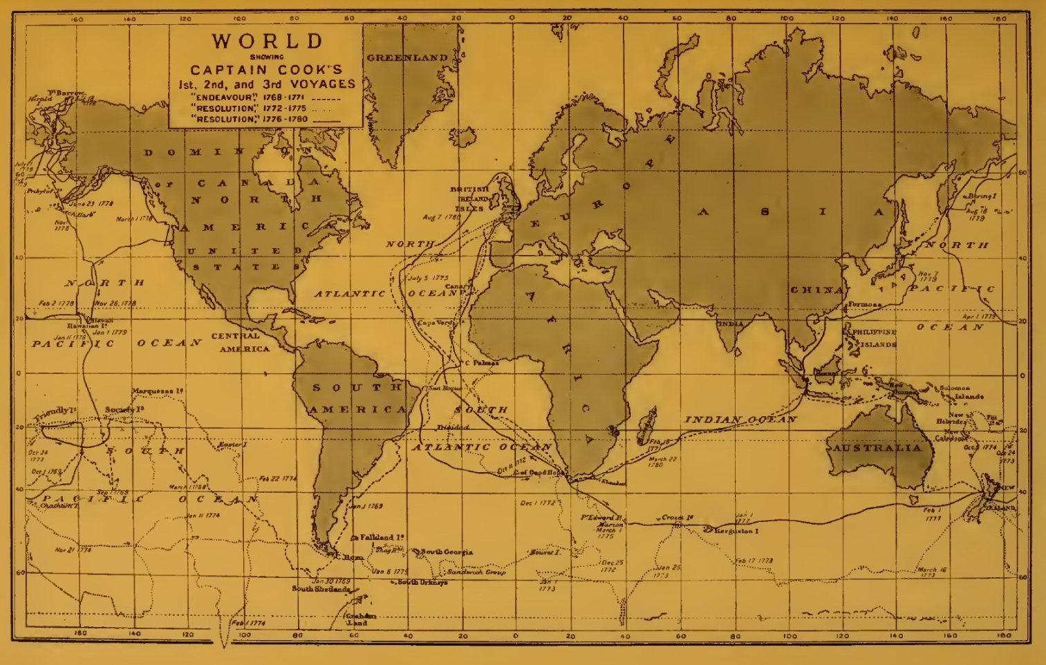
Routes of Captain Cook's 1st, 2nd and 3rd Voyages.
Click on the map to enlarge it.
The conclusion of the last of Cook's great voyages of discovery forms a fitting close to the present chapter, and before continuing the narrative of Pacific exploration it will be desirable to look back at the course of discovery by the Russians during the eighteenth century in Northern and North-Eastern Asia, with which the work of Pacific navigators had begun, as we have seen, to show points of contact.
{Page 256}
It has been seen in a former chapter that the journeys of the Russian adventurers who had spread over Siberia during the seventeenth century had brought about a general knowledge of that vast region as far as the shores of the Pacific. The extremity of the Old World had, it is claimed, been rounded by the Cossack Deshnef, while the remote shores of Kamchatka had been brought within the cognisance of the Russian authorities. But the results of these journeys had never become widely known, and there was much vagueness in the information acquired by the travellers themselves. In the eighteenth century these rough and ready methods began, here as elsewhere, to give place to more precise and scientific procedure, leading to results not entirely to be dispensed with at the opening of the twentieth century. The impulse towards further effort was due to Peter the Great, who during the latter part of his life showed a keen interest in the acquisition of a better knowledge of these remote parts of his Empire, especially as regarded the relations of Asia to America. He did not live to see much of the work accomplished, but a good beginning, at least, had been made before his death.
About 1710, attention was called to reports of the existence of islands in the frozen sea to the north of the Siberian coast, and in the following year two separate expeditions were equipped for the purpose of settling the question. The first, destined for the coast east of the Yana, was entrusted to the Cossack Merkurei Vagin, and he was accompanied as guide by Jacob Permakof, who had deposed to having once seen an island on the far side of the Sviatoi Nos. The explorers reached this cape, and, sailing north, discovered (so it was said) an island 9 to 12 days in circumference, beyond which they thought they saw another large land. On the return the party suffered so much that both Vagin and Permakof were murdered by their men, in revenge for having involved them in such hardships, and great doubt exists as to the reality of the supposed discovery. The second expedition, under Vasilei Stadukhin, reached a promontory running east from the mouth of the Kolyma, but the way was stopped by ice, and no island could be seen. In 1715, Alexei Markof went north from the mouth of the Yana, travelling over the ice with sledges, but he too saw no trace of islands. In 1724, one Feodot Amossof searched for islands, first sailing east from the mouth of the Kolyma and afterwards going over the ice with sledges. He reported the discovery of land, on which were huts covered with earth, but it was of no great size and only distant a day's journey from the coast, so that in any case the discovery was of slight importance, while some have altogether doubted the truth of Amossof's statements. Thus the efforts in this direction led for a time to exceedingly slight results, and even if the island said to have been seen by Vagin was one of the New Siberia group, it was not until many years later that the discovery was effectively followed up.

Sketch-map of North-eastern Siberia.
In an easterly direction, the newly awakened enterprise of the Russians was decidedly more successful. We have seen in a former chapter that Kamchatka had been reached by Atlassof about 1697, and that Russian influence soon began to extend over the greater part of the country. The enquiries here made elicited some vague information about the islands beyond, and some indications of a large land to the east—probably the American continent—seem also to have been gathered. In 1706 the southernmost point of Kamchatka was reached, and the nearest of the Kurile Islands sighted. In 1710, some shipwrecked Japanese fell into the hands of the Russians, and supplied information on the geography of the lands to the south. In 1712 and 1713, two expeditions to the Kuriles were conducted by the Cossack Ivan Kosirevski, who collected some fairly precise information and put down the results in a series of charts. With regard to the Japanese islands, the enquiries led to the belief that Yezo really consisted of several distinct islands, though it had been shown correctly as one by the Dutch navigator Vries in the Kastrikom, whose voyage has been spoken of in a former chapter. The route hitherto followed to this remote region was the difficult northern one by the Anadyr, but about this time efforts were made to open up a shorter and more southerly route across the Sea of Okhotsk. In 1712 and 1713, two parties of Cossacks explored the shores of that sea and examined the Shantar group of islands lying in about 55° N. In 1714, orders came from the Czar Peter to attempt the voyage to Kamchatka, and the Cossack Sokolof was sent with some sailors and ship's carpenters for this purpose. Among the sailors was a Dutchman from the town of Hoorn, Henry Busch by name. A vessel was built and a first voyage undertaken in 1716. The navigators at first followed the coast in an easterly direction, but encountering an adverse wind were driven across to the west coast of Kamchatka just north of the Tigil. The coast was examined as far as the mouth of the Kompakova, where they wintered, returning to Okhotsk the next year after a tedious voyage, owing to obstructions caused by ice.
In 1719, the Czar himself issued instructions to the surveyors Evreinof and Lushin for an expedition across Siberia to Kamchatka, and thence to the region where the two continents were expected to approach most closely. The text of this document—still in existence—was annotated by the Emperor's own hand. The venture was not successful, for the farthest point reached seems to have been one of the Kurile Islands. But the project was not allowed to lapse, and before his death in 1725, the Emperor once more drew up instructions for an expedition, this time placed under the command of Vitus Bering, then a captain in the Russian navy. The choice was a fortunate one, for Bering, by his skill and determination, achieved results which place him in the front rank of explorers of the far North-East. With his coadjutors Lieutenants Martin Spangberg and Alexei Chirikof, he set out from St Petersburg in February, 1725, and, after some time had been spent in the tedious work of transporting the stores across the whole length of Siberia, the party was at length reunited at Okhotsk in July, 1727. Even then there was much to be done before the real work of discovery began. A new vessel had been built at Okhotsk, and in this the expedition crossed over to Kamchatka, which was crossed by means of sledges during the winter. At the Nishne Kamchatka fort, the principal settlement on the east coast, another vessel was built and named the Gabriel. In this the explorers set sail on July 20, 1728, following the coast to the north-east and carefully charting it. On August 10 they sighted the island which still bears the name St Lawrence, given to it on this occasion from the Saint associated with that date in the calendar, and on the 15th reached a point (in 67° 18' N. according to their observations), where the coast bent decidedly to the west, and Bering correctly concluded that he had passed the farthest extremity of Asia. The point seems to have been that known to the Russians as Serdze Kamen (in 67° N., according to Nordenskiöld), and Bering had therefore followed the northern coast of the continent beyond the point where it approaches nearest to America. He for the first time laid down the coast-line accurately in a map, and though the voyage of Deshnef had, many years earlier, shown to those acquainted with its results that the continents were separated, the intervening strait deservedly bears the name of the later and more scientific explorer.[1] Bering now turned, as he feared he might be entangled in the ice, but did not give up the hope of effecting some discovery to the east. After reaching the Kamchatka river on September 20 (old style), and spending the winter in that region, he set out again in June, 1729. But adverse winds prevented him from reaching any land, so turning back, and rounding the south point of Kamchatka, he reached Okhotsk on July 23. One useful result of this voyage was the determination of the exact position of the south end of Kamchatka, for many false ideas were current in Europe at the time, some supposing (and the idea held its ground to some extent even after Bering's voyage) that this peninsula and Yezo formed one continuous land, as may be seen delineated in some maps of the period.
[1 Within recent years Deshnef's name has been given to the easternmost point of Asia.]
Some time now elapsed before Bering renewed his efforts at exploration to the east of Kamchatka, but meanwhile Afanasei Shestakof, commander of the Cossacks at Yakutsk, came forward with proposals for a new attempt. He was successful in his application, and a large expedition was set on foot, the command being given jointly to himself and to Dmitri Paulutzki, a captain of dragoons, while among the subordinate members was Michael Gvosdef, a surveyor. The two leaders separated (apparently owing to a dispute), each prosecuting the enterprise independently. Shestakof reached Okhotsk in 1729, and sent his cousin, Ivan Shestakof, in the Gabriel (Bering's ship) to map the islands between Okhotsk and Kamchatka. He himself followed in the Fortuna, but met with shipwreck, and, though then escaping the fate of most of his men, subsequently lost his life in an engagement with the Chukches. At the same time a voyage seems to have been made independently, under his orders, and in it Gvosdef apparently took part, for it is recorded that in 1730 he reached a land opposite the Chukche country in 65° 66' N., which must, it seems, have been the American continent.
Paulutzki had meanwhile made his way overland to the posts on the Kolyma, and in 1731 proceeded against the Chukches, his march helping to a somewhat better knowledge of the region of the Upper Anadyr. Several engagements were fought, and the force made its way along the north coast beyond the "Chukotskoi Nos", apparently as far as Bering's turning point. The geographical results of the whole undertaking were, however, by no means striking.
It was in the following year that, largely through Bering's initiative, but with the warm support of Kirilof, secretary of the Senate, a series of expeditions was planned, which proved of the greatest importance for the geography of north-east Asia. A comprehensive scheme was drawn up and preparations were made with the greatest thoroughness. The aid of the Academy of Sciences was invoked, and some of its members—Gmelin the naturalist, De la Croyere the astronomer, and the historian G.F. Müller—volunteered to take part in the enterprise for purposes of research, while a number of naval officers were appointed to command the several expeditions contemplated. The objects in view were not only the exploration of the still unknown area between Asia and America, but the complete survey of the northern coasts of Siberia, as well as explorations within the vast interior of that country.
The work to which the greatest importance was attached was the prosecution of discovery east of Kamchatka, this being entrusted to Bering himself (appointed Commodore), and his associates Spangberg and Chirikof. Spangberg was sent forward with the heaviest materials in February 1733, and proceeded to Okhotsk to superintend the building of ships. A start was made during the same year by Bering and by the members of the Academy, Chirikof bringing up the rear still later. A good deal of delay occurred in the preparations for the eastern voyage, and the interval was utilised by the Academicians in surveys and scientific researches on land. De la Croyère accompanied Chirikof to the mouth of the Ilim and thence went viâ Irkutsk to Lake Baikal and the Upper Amur. Gmelin and Müller ascended the Irtish, and proceeding by Tomsk to Yeneseisk, spent the summer of 1735 examining the region east of Baikal, while in 1736 they turned their attention to the upper basin of the Lena. Unfortunately a fire at Yakutsk caused the loss of all Gmelin's itineraries, and he therefore returned in 1737 to the Upper Lena, while De la Croyère went to the lower parts of the same river and thence to the Olenek. Meanwhile Müller, as his health had broken down, gave up the idea of proceeding on the eastern voyage, but was commissioned to stay in Siberia and extend his knowledge of that country by further travel. Gmelin also obtained his recall, but the loss of these helpers was made good by the arrival, in 1738, of the naturalist George William Steller, who eventually took part in the main expedition. A student named Krasheninikof had already been sent forward to Kamchatka, and it is to him we owe the first scientific account of the country.
By these several journeys a scientific basis was for the first time supplied for the mapping of Siberia in its broad outlines, though large gaps of course remained, and have only been partially filled in in our own day. During the same period several voyages were undertaken on the north coast with a view to testing the possibility of a passage by sea, such as had been the dream of so many of the early navigators in the sixteenth and early seventeenth centuries. The first of these was devoted to an examination of the most westerly part of the route, from Arkhangel to the Ob. This voyage was under the command of Lieutenants Pavlof and Muravief, who sailed in 1734 and entered the Kara Sea, but returned to winter at Pustozersk on the Pechora. In 1735 they again passed through the Yugor Shar into the Kara Sea and followed the coast as far as 77° 30' (by their reckoning), but then turned back without reaching the Ob. In 1736 and 1737 the quest was taken up by Lieutenants Mlyagin and Skuratof, who passed the Yamal (Yalmal) peninsula and sailed up the gulf into which the Ob debouches. The next section of the passage, between the Ob and the Yenesei, was successfully accomplished in 1737, after three previous failures, by Lieutenant Owzin, accompanied by Ivan Koshelef. During Owzin's four voyages the shores of the gulfs of Ob and Taz were carefully mapped. In 1738 the work was continued by Minin (who had previously been with Owzin and Koshelef), with Sterlegof as mate. During the first two summers little advance was made, but in the winter of 1739-40 Sterlegof pushed on with sledges along the west coast of the Taimur peninsula as far as 75° 26', and in the following summer the ship was taken almost as far, the voyagers then returning on account of snow-blindness. They had done a creditable piece of work, for the coast beyond the Yenesei, almost as far as the Lena, was till then virtually unknown; the great northward projection of the peninsula terminating in Cape Chelyuskin, and the remoteness of this part of the coast from the main centres of Russian occupation in Siberia, rendering it the least accessible of all. Meanwhile exploration of the section east of the Taimur was being carried out from the Lena as a base, whence voyages were made both to the west and east. Setting out from Yakutsk in 1735, Lieutenant Prontchishchef, with the mate Chelyuskin, wintered on the Olenek, and during the next summer passed the mouths of the Anabara and Khatanga. But he found his way barred by islands and ice-bound channels before reaching the extremity of the Taimur peninsula, though he reached the latitude of 77° 25' (or 29' according to one account) in the endeavour to turn these obstacles. He died soon after his return, and his young wife, who had accompanied him, two days later. The task was taken up in 1739 by Lieutenant Khariton Laptef, assisted by Chelyuskin and Chekin. After reaching Cape Thaddeus, on the east side of the Taimur peninsula, during the first summer, Laptef took his ship back to winter-quarters on the Khatanga, but lost it in 1740 while attempting to return. The rest of the journeys had therefore to be carried out by land, but they were successful in affording surveys of the greater part of the coast of this northern extremity of Siberia as far as the Yenesei. In one of his journeys, carried out in 1742, Chelyuskin seems to have rounded the northern extremity of the Old World—the cape which now bears his name.

Sketch-map of North-western Siberia.
From the Lena eastward the sea had frequently been navigated, as we have already seen, though the vessels employed had been little fitted for successful voyages in such seas. Small success likewise attended the newer efforts. In 1735 Lieutenant Lassinius, who had started from Yakutsk with Khariton Laptef, advanced hardly 100 miles east of the Lena delta, and on wintering in this region his party was attacked by scurvy, and the leader and many of his men died. The attempt was renewed in 1736 by Dmitri Laptef, who, however, hesitated to risk an advance through the ice, and returned without effecting anything. In 1739 he succeeded in rounding the capes east of the Lena (Borkhaya and Sviatoi)—which had seemed impossible on the former voyage—but was then frozen in. During the winter some good survey work was done. In 1740 Laptef sailed past the Bear Islands, but was brought up by the ice off Great Cape Baranof. He remained in this region till 1742, and, his efforts to advance by sea being still frustrated, went overland to the Anadyr and made a survey of the route. This closed the attempts at exploration on the north coast for a time.
While superintending the general progress of the whole series of expeditions, Bering's own preparations for his eastern voyage advanced but slowly, and he had seen all the subordinate undertakings well under way before finally setting out himself. The last of those expeditions to be spoken of is that of Bering's old associate Spangberg, to whom was committed the task of exploring the region between Kamchatka and Japan, about which, as already mentioned, much uncertainty still prevailed. Three vessels in all took part in the voyage—the Archangel Michael under Spangberg himself, the Hope under Lieutenant Walton, and the Gabriel, previously used for the first Kamchatka expedition, under Midshipman Sheltinga. The start was made from Okhotsk in June, 1738, the sea having till then been blocked by ice. After making arrangements for wintering in Kamchatka, Spangberg undertook a preliminary reconnaissance of a part of the Kuriles (as far as 46° N.), postponing the main voyage till 1739. In May of that year the explorers again sailed for the Kuriles, but in the following month the commander and Lieutenant Walton became separated in a gale, and continued the voyage independently, both reaching Japanese territory and opening up friendly intercourse with the inhabitants. Spangberg, accompanied by Sheltinga, struck the coast of the main island (according to his reckoning) in 38° 41' N., and advanced south to 38° 25'. On the return voyage he touched at a part of the island of Yezo, placed by him in 43° 50' N., and here made the acquaintance of the hairy Ainus. He continued his explorations in this region, and again sighted land (Matsumai) in 41° 22' N., apparently taking it to be a different island from that already visited, though it must really have been the southern extremity of Yezo. He thus failed to set at rest all the uncertainties about the lands north of Hondo, though he did good service in determining the position of Japan relatively to Kamchatka. He was back at Okhotsk early in September.
Walton touched at various points on the Japanese coasts, reaching a town of some size in the neighbourhood of 33° 48' N., and seeing a large number of Japanese vessels. Before beginning the return voyage he stretched eastward with a view to ascertaining if more land existed in that direction, but, not finding any, made his way to Kamchatka and Okhotsk, reaching the latter more than a week before Spangberg. For the purpose of verifying and completing his surveys, Spangberg undertook a second expedition in 1741-42, but as he hardly advanced beyond the most northern of the Kuriles, it was entirely without result.
The preparations for the eastern voyage under Bering himself had meanwhile at last been completed, and the two vessels St Paul and St Peter left Okhotsk September 4, 1740, under the respective commands of Bering and Chirikof. The winter was spent at the port in Avacha Bay which has ever since been known as Petropavlovsk from the names of the two ships. The real voyage of discovery—the most important yet made in these seas—commenced June 4, 1741, the scientific experts, Steller [1] and De la Croyère, having meanwhile joined the ships. The expedition sailed at first a little east of south, but finding no land in this direction, stood to the north-east and soon encountered a severe storm, in which the ships became separated, never to meet again during the whole voyage. On July 29 (new style) Bering sighted the great peak of Mount St Elias, which received its name on this occasion. It was taken to be a volcano—erroneously, as we now know. Hence he endeavoured to follow the coast to the north-west, but was hampered by constant fog. It is somewhat difficult to trace his movements in detail, but he is known to have passed close to the outer side of Kadiak Island, to have sighted a portion of the Alaska peninsula, and to have spent some days at the Shumagin Islands, afterwards passing south of the line of the Aleutian Islands. Some of the volcanoes in these were sighted from a distance, and thus for the first time brought to light. Meanwhile Chirikof had reached the American coast considerably more to the south and east (in about 56° N.), and a few days earlier than Bering. A disaster occurred almost immediately, for two boats' crews, which had been sent on shore in succession, were never again heard of, having in all probability been killed by the natives. The loss of the boats was a great calamity, for it was now impossible to land, though the coast was followed for some distance. About the middle of August the two ships seem to have been simultaneously in about the same locality (south-east of the Shumagin Islands), but they did not sight each other. Like Bering, Chirikof was much delayed by adverse winds and fog, and, water falling short, the crews suffered greatly, and their case was rendered worse by the appearance of scurvy, the astronomer De la Croyère being one of the victims to this disease when actually in sight of land. Avacha Bay was, however, reached by the scanty remnant of the original crew on October 11, 1741.
[1 This naturalist had come out with a view to taking part in Spangberg's second voyage, but was persuaded by Bering to change his plans.]
Bering was not so fortunate, being himself attacked by scurvy, while so many of his men were disabled that the ship could not be navigated among the many dangers of these unknown seas. The chief responsibility now devolved on Lieutenant Waxel, whose efforts were zealously seconded by the naturalist Steller. But the ship drifted about at the mercy of the elements, and, on reaching the island which has since borne Bering's name, it was almost by a miracle, in the enfeebled state of the crew, that it found its way into a sheltered basin, nearly surrounded by rocks, on November 15, 1741. The island, which was at first supposed to be a part of the mainland, was a new discovery, and the enforced stay during the winter of 1741-42 produced valuable additions to knowledge through Steller's admirable descriptions of the animal life and the general character of the region. The now extinct marine mammal known as Steller's sea-cow (Rhytina gigas) was here observed for the first time. The island was devoid of trees and human habitations and the only means of obtaining shelter was by enlarging some pits found in the sandhills and covering them with the ship's sails. Bering was already greatly enfeebled at the time of his arrival, and he died on December 19, only a month after being carried on shore. Many of the crew, of whom the scurvy had taken too firm hold to permit them to benefit by the stay, also died, among them the pilot Hasselberg, aged 70, and the mate Chitaingof. Steller alone maintained his health, and he was untiring in his efforts to better the condition of the men, of whom 45 lived to see the advent of spring. They supported life on the flesh of various marine animals, including sea-otters, whose skins formed likewise a valuable commodity. During the winter the vessel was stranded and became a total wreck, so that the only means of safety left was to build a new vessel with the material saved from the old one. This work was successfully accomplished under the direction of a Cossack named Starodubzof, who had been employed in a subordinate capacity in ship-building at Okhotsk. The vessel was launched on August 21, 1742, and the voyage to Petropavlovsk was accomplished without mishap, that port being reached on September 5. Thus ended this unfortunate voyage, which had nevertheless done much to improve the knowledge of the coasts of North-West America and of their relation with those of Asia. With Bering's previous voyages, it entitles the Danish captain to a high place among the world's navigators.

The Bering Strait region, according to the map prepared
for the St Petersburg Academy of Sciences. (Outline
sketch.)
A large part of the results attained had been due, as we have seen, to the energy of the naturalist Steller, who unfortunately met with a fate little in accordance with his merits. Having stayed in Kamchatka for purposes of research, he became embroiled with the authorities and was called to Yakutsk to answer for his conduct. He made so good a defence that he was allowed to start homewards, but was recalled through orders from St Petersburg, and died—of a fever according to Müller—at Tiumen in November, 1746. Müller and Gmelin had completed their researches and reached St Petersburg early in 1743, with which year the vast efforts put forth by the Russian Government to increase the knowledge of Siberia and neighbouring regions reached, for the time, its conclusion. Something was, however, done, largely by private individuals, to extend the knowledge thus gained.
The conception current about this time of the geography of this region, and particularly of the relations between Asia and America in the far north, is well shown by the map published by Müller in 1754 (and in a revised form in 1758) under the auspices of the St Petersburg Academy of Sciences. An outline sketch of this, as reproduced by the French cartographer Bellin in 1766 (and soon afterwards by Thomas Jefferys in this country) is given on the opposite page.
Russian hunters and trappers now began to push over to the American side of Bering Sea, and the numerous islands of the Aleutian Archipelago began gradually to appear, though but vaguely, on the charts. Among the names most deserving of mention in the ranks of these early pioneers are those of Nevodsikof, who in 1745 first examined the Fox Islands (as the eastern section of the Aleutian Archipelago was then called); and Stephen Glottof, who, with the Andrean and Natalia, in 1762 sailed beyond the Fox Islands to Kadiak, of which he gave the first definite account. In 1764 Lieutenant Synd undertook a voyage to the more northern parts, near Bering Strait, but it was only in 1767 that he made any great advance. After visiting certain islands in the Bering Sea (said to be between 61° and 62° N.) he reached a land which he considered to be the American continent between 64° and 66° N., but made no effort to survey it, and soon afterwards began the return voyage. In 1768 and 1769 a government expedition under Krenitzin and Levashef resumed the examination of the Fox Islands and coast of Alaska, on which last Krenitzin wintered. This brings us to the position of affairs at the time of Cook's third voyage, spoken of in the last chapter, which did more to shed a clear light on the geography of this region than al] the voyages since Bering's time. By this date a Russian company had been formed for the exploitation of the fur trade on the American side, and an important step was taken by Shelekof, between 1783 and 1787, in the founding of a station on Kadiak Island, which served as a base for operations on the coasts beyond. Meanwhile, aroused by the brilliant results of Cook's voyages, other nations came forward to take part in the work, and the exploration of this same region was part of the programme of the celebrated French voyage under La Pérouse. From the English side, too, the work was continued by a series of voyages which, like the French voyage just alluded to, will be spoken of in the next chapter. They were to a large extent contemporaneous with the Russian voyages now to be mentioned, so that in considering these it must be remembered that the results achieved had in many cases been anticipated by the rival claimants. for the profits of the fur trade.
Almost immediately after the station on Kadiak had been established, an important voyage was undertaken by the pilots Ismaelof [1] and Becharof, under the orders of the Governor-General at Irkhutsk. Sailing from Kadiak in 1788, in the galiot called the Three Holy Fathers, they explored the neighbourhood of the Bay of Chugatsk—the Prince William Sound of Cook—and afterwards examined portions of the coast to the east and south-east, including Yakutat Bay, already visited by the English Captains Portlock and Dixon. The farthest point reached seems to have been in about 57° or 58° N., where a bay was examined which was probably that discovered by Portlock in the previous year, and since known as Portlock Bay. Scurvy now made its appearance, and the voyagers turned their vessel homewards, postponing further attempts at discovery.
[1 Met by Cook and by him called Smyloff (see p. 252).]
The only other Russian expedition to this region, undertaken before the close of the century, which need be mentioned here, is that entrusted to Captain Billings, an officer in the Russian service who had taken part in Cook's last voyage and who had made an abortive attempt to push east by sea from the mouth of the Kolyma in 1781, The proposal for this expedition was made by Dr William Coxe, the English historian of these Russian voyages, through the well-known naturalist Pallas. Billings had with him as secretary Martin Sauer, to whom we are indebted for the fullest account of the voyage. Nothing of great importance was effected. In 1785 the explorers started from St Petersburg and proceeded to Okhotsk, where two vessels—the Glory of Russia and Good Intent—had meanwhile been built. Billings sailed in the first of these in October, 1789, and after wintering at Petropavlovsk, started thence in May, 1790. He visited Shelekof's settlement in Kadiak Island, then under the charge of Delaref, and touched at Montague Island, Prince William Sound, and Kaye's Island, from the last of which he sighted Mount St Elias in the north-east early in August. But his stock of provisions was now failing, and he sailed back to Kamchatka, reaching Petropavlovsk at the end of October, after considerable sufferings from want of food and water. The Good Intent had been wrecked at the outset of the voyage, but as a second attempt was to be made in 1791, another vessel was built during the winter under the direction of Captain Hall, who was to command her. Billings sailed first in the Glory of Russia, but after reaching Unalaska early in July he gave up the idea of further exploration eastward, and quitted the ship, hoping to survey the Siberian coast during a land march to the Kolyma. But the veiled hostility of the Chukches frustrated this design, and no results of importance were gained by a six months' journey, during which the party suffered much from cold and want. The command of the Glory of Russia had meanwhile been taken over by Captain Sarychef, who joined Hall at Unalaska. The crews passed a miserable winter at Illuluk Bay, returning to Kamchatka in the following spring. Little had therefore been gained, in spite of the elaborate preparations; the principal result being the observations on the countries and people visited, which were put down by Sauer in his narrative. Thus ended, for the time, the Russian enterprises for the exploration of the American coasts opposite Eastern Siberia.
During the latter half of the eighteenth century some attempts were once more made to throw light on the northern coasts and islands. A Yakutsk merchant, Shalaurof, made an expedition at his own expense in 1760-62, but though he rounded the Sviatoi Nos and sighted Liakhof Island, he seems neither on this nor on a subsequent expedition in 1766, which proved fatal to his whole party, to have rounded the north-eastern point of Asia. In 1763 a sergeant, Andreief, was sent on a journey northward over the ice, and is said to have reached some islands, but these cannot be identified with certainty. Three surveyors—Leontief, Lussof, and Pushkaref—continued the search in 1769-71, but accomplished nothing. In 1770 a beginning of exploration of the New Siberia Islands was made by Liakhof, whose name has since been attached to the most southern island of the group. He also discovered Maloi and Kotelnoi islands. The work was prosecuted by various adventurers, among them Sannikof, who in 1805 discovered two more islands, and Hedenström, an exile who executed a partial survey of the group under government orders, in 1809-10. Sannikof also continued his explorations, and reported that he had seen land to the north-east from New Siberia, the existence of which remained still a subject of discussion nearly a century later. But these and subsequent journeys belong rather to a later period than that dealt with in the present work.
{Page 273}
We now resume the story of exploration in the Pacific, as pursued by the nations of Western Europe. The unequalled success attained by Cook in his three voyages drew universal attention to this field of research, and it was but a few years after his death that a new French expedition was organised to continue the work of the English navigator. During the war between Great Britain and her revolted colonies, in which France had intervened on the side of the latter, King Louis XVI had shown sufficient enlightenment and interest in scientific discovery to order that the French war-ships should in no way molest the English navigators, should they be encountered; and when peace was at last concluded in 1783, he took a personal interest in the preparations for a French expedition, the command of which was entrusted to François Galaup de la Pérouse, an officer who had distinguished himself during the war by several successful actions against the British. In particular, he had been in command of the daring expedition to Hudson Bay in 1782, during which, after successfully overcoming the risks of navigation through the ice and fogs of that region, he had taken and destroyed the British posts at the south end of the bay, distinguishing himself no less by humanity to the vanquished than by intrepidity and resolution in carrying out his task. Two frigates, the Boussole and Astrolabe (in which names the scientific aims of the expedition were shadowed forth, and one at least of which was to become particularly famous in the annals of exploration), were placed under his command, the captain of the Astrolabe being the Chevalier de Langle. The personnel included various scientific experts, among others Bernizet, Lepaute-Dagelet, De Lamanon, De la Martinière, and Dufresne. Cook's last voyage had called attention to the work still to be done on the shores of the Northern Pacific, on which, during the last two decades of the eighteenth century, the efforts of maritime discovery were largely concentrated, and this region was chosen as one of the special fields of activity of the French expedition.
The ships sailed from Brest on August 1, 1785, and early in the following year the passage round Cape Horn was effected without difficulty. After touching at the coast of Chile and at Easter Island, La Pérouse steered at once for the Sandwich group, sighting Hawaii on May 28, 1786, and coming to anchor off Maui the following day. No long stay was made in the group, but after obtaining some refreshments, the voyagers stood over for the American coast, which was reached near Mount St Elias. Following the coast to the east with a view to finding shelter for the ships. La Pérouse passed Cape Fairweather on July 2, and found a nearly land-locked bay, which received the name Port des Français. Its latitude was found to be 58° 37' N. and it was therefore situated a little south of Mount Fairweather. Some dealings were had with the natives, who made but a poor impression on the voyagers, nor did their country arouse much enthusiasm. It was on preparing to leave this bay, where some refreshment had been obtained, that the first misfortune, of the many which overtook the expedition, was experienced. Three boats had been sent to buoy the channels of the bay, and of these, two became caught by the strong current, and their occupants, 21 in all, were drowned. Continuing his voyage on August 1, 1786, La Pérouse traced the coast southwards, and came to the correct conclusion that it was fringed by an archipelago of islands, though only the outer side of these was examined. A fine bay was named after the Russian navigator Chirikof, and a group of islands after his associate, the French savant De la Croyère. Arriving at a projecting headland, which he named Cape Hector (the southern point of the group since known as the Queen Charlotte Islands), he partially examined the inlet running up behind it, which received the name Fleurieu Gulf. Passing and naming the Sartine and Necker Islands, he finally put in at Monterey Bay in California, having examined the greater part of the North American coast south of Mount St Elias. Part of his survey was a duplication of the work of the Russians and English about the same time, but even here it was of value as supplying an independent and trustworthy delineation of this little-known coast-line.
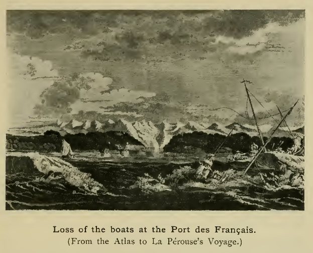
Loss of the boats at the Port des Français.
(From the Atlas to La Pérouse's Voyage.)
The expedition made a stay of some weeks in Monterey Bay, and then, in November 1786, sailed for China, passing north of the main islands of the Sandwich group, and narrowly escaping disaster on a reef which was named Basse des Frégates Français. The volcanic island of Assomption (Asuncion) in the Ladrones, and the Bashi islands, were afterwards sighted, and Macao was reached at the beginning of January, 1787. Finding no despatches here, the commander decided to refit in the Philippines, and while in the port of Manila received a visit from the frigate La Subtile, under De Castries, which had just taken part in a voyage with D'Entrecasteaux by an unusual route (unusual at least for the time of year) from Batavia to Canton, east of the Philippines. This was the first geographical achievement of D'Entrecasteaux, who was destined to distinguish himself in the search for the ill-fated expedition now being described. Two officers and eight men were received from La Subtile to partly replace those that had been lost.

La Pérouse's routes in the seas north of Japan.
(Outline sketch of his chart.)
La Pérouse now began the second part of his programme—the examination of the coasts of North-eastern Asia between Japan and Kamchatka. In spite of all the Russian enterprise in this region, and in particular the creditable results of Spangberg's voyage, a good deal remained to be done to elucidate its geography. It was still quite uncertain whether Sakhalin was, or was not, a part of the mainland, while the exact relations of the island of Yezo were equally obscure. Setting sail on April 9, 1787, the ships passed Formosa and the Liu-kiu group, and though much impeded by fog, sighted the island of Quelpart on May 19, and passed through the strait between Japan and Korea, hugging the coast of the latter. Making a zigzag course through the Sea of Japan, and then sailing along the coast of Manchuria, the navigators were deceived by a strange optical illusion, caused by a thick bank of fog, which presented all the appearance of a mountainous coast line to the south, seamed by ravines and seeming to be separated from the continent by a narrow strait. On June 23, the ships anchored in a bay on the coast of Manchuria which received the name of Ternay. On the 27th they proceeded along the coast and soon sighted the opposite coast of Sakhalin, where La Pérouse entered into friendly intercourse with the natives and gained intelligence as to the geography of the surrounding region. He advanced north almost to the narrowest part of the strait separating Sakhalin from the mainland, but then found progress stopped by a submarine bank stretching across the channel. He therefore put into a bay on the side of the mainland, which he named De Castries, and on August 2 turned south in order to round the southern point of the island. This he did successfully, naming the point Cape Crillon. By thus passing between Sakhalin and Yezo, by the strait which now bears his name, La Pérouse did a useful piece of work, showing that the two islands were entirely separated. With these discoveries he was for the time satisfied, and made his way through the Kuriles, by La Boussole Strait, to Kamchatka, reaching Avacha Bay on September 7. Here news from home at last reached the wanderers. La Pérouse receiving intimation of his promotion to the rank of "Chef d'Escadre." At Petropavlovsk, M. Lesseps was left behind for the purpose of taking home despatches by the overland route through Siberia, a task which he successfully accomplished. The ships sailed south on September 30, and in the following December reached the Navigators' Islands of Bougainville, anchoring off Manua. The reception by the islanders was at first friendly, but an unfortunate occurrence marred these good relations. Captain De Langle and a number of his men, including the naturalist Lamanon, being massacred during a visit to the shore. Magnanimously refusing to make reprisals, the commander sailed away to the south-east, reaching the Friendly Islands before the end of the year, and making his way, by the end of January, 1788, to the coast of New South Wales, where he found the English busy with their new settlement at Port Jackson, and met with a friendly reception. He sailed away in February and no direct news of his expedition was ever again received. The search carried out by D'Entrecasteaux led to but negative results, and it was only about 30 years later that some light was accidentally thrown on the closing scenes of the voyage by the English Captain Dillon.
While touching at the island of Tucopia (north of the New Hebrides) in 1826, Captain Dillon found European objects among the natives, including a sword-hilt of French manufacture, and learnt that two European ships had many years before been lost off the coast of Manicolo or Vanikoro in the Santa Cruz group (sometimes considered part of the New Hebrides), and that these articles had been derived from the wrecks. On reaching Calcutta, he prevailed upon the Indian government to despatch him for the purpose of clearing up the mystery, and rescuing any possible survivors. The voyage was accomplished in spite of many difficulties, and the enquiries made at Vanikoro left no doubt that the ships wrecked had been the Boussole and Astrolabe. Many other articles, undoubtedly once belonging to their equipment, were obtained, and Captain Dillon learnt by careful enquiry that the ships had struck on the reefs on the west side of the island, one being lost immediately; that the crew of this ship escaped to the shore, but were murdered by the natives; and that those on board the other, which did not break up at once, built a smaller vessel out of her timbers, and eventually sailed away. Even if the latter information was correct, there can be no doubt that these too ultimately perished, though their exact fate must for ever remain a mystery, as no further traces of the expedition have ever been met with.[1]
[1 An attempt has lately been made in Australia to connect a wreck found in 1861 on the Queensland coast with the vessel built by the survivors of La Pérouse's voyage; but the evidence in favour of the theory seems quite insufficient.]
While the French government had thus taken up the work of Captain Cook with a single eye to the enlargement of geographical knowledge, a number of other undertakings were set on foot at the same time with a view to commercial profit through the exploitation of the fur trade on the north-west coast of America.[1] These too contributed not a little, incidentally, to a better knowledge of that complicated coast, with its archipelagos and labyrinths of channels. In 1785 a ship named the Sea Otter was fitted out by English merchants in China, and sailed under Captain Hanna, who visited Nootka or King George's Sound and examined various bays and islands on the neighbouring coast. Among the former was Fitzhugh's Sound, a little north of Vancouver Island, which still retains the name given it on this occasion. Hanna returned to the same coast in 1786, which year saw the arrival in these parts of three other British expeditions, each of two ships, in addition to that of La Pérouse. One had been fitted out in England in 1785 by a body of merchants (among them Richard C. Etches) who obtained from the South Sea Company licence to trade on the coast of North-West America for a term of years. It was commanded by Captains Portlock and Dixon, both of whom had taken part in Cook's last voyage, and who sailed in the King George and Queen Charlotte respectively. In 1786, the Bengal merchants fitted out the Nootka and Sea Otter, commanded respectively by Captain Meares and Lieutenant Tipping; while those of Bombay despatched Captains Lowrie and Guise in the Captain Cook and Experiment, the commercial operations being in the hands of Mr James Strange.
[1 It was the sea-otter, abundant at the time on this coast, which supplied the bulk of the skins. A drawing of it made during Cook's third voyage is reproduced on p. 251.]
Portlock and Dixon made their way to Cook's River, but went south to winter in the Sandwich Islands without accomplishing much. In the spring of 1787 they returned to the American coast, visiting Prince William Sound to the east of Cook's River. In this neighbourhood they encountered Captain Meares, who had wintered not far off His crew had suffered severely from scurvy, and Portlock was able to render him some assistance, though on terms with which Meares saw little cause to be satisfied. In May, Portlock and Dixon separated, both afterwards touching at various points on the coast. The former discovered a harbour just south of Cross Sound, to which he gave his own name. Here he had some intercourse with the natives and sent a party to explore eastward, but, on leaving, sailed for the Sandwich Islands and China without making further discoveries. Dixon did somewhat more, for after touching at Yakutat Bay (which he named Port Mulgrave) and other points on the coast, he entered the channels both to the north and to the south of the Queen Charlotte group of islands (to which he gave the name of his ship), and thus virtually proved its separation from the continent, though without actually traversing the whole intervening space. The northern end of the dividing channel has ever since borne his name (Dixon Entrance). The hardships endured by Meares and his men prevented them from making discoveries, while though Lowrie and Guise seem to have traced a considerable stretch of coast-line in 1786, they failed to make the results widely known. They seem however to have touched at the outer side of the Queen Charlotte group, and it was during the voyage of the Experiment that the northern entrance to the strait which separates Vancouver Island from the mainland received its name Queen Charlotte's Sound. During 1787 another ship, the Imperial Eagle, sailed from England for North-west America under Captain Barclay, who examined the opening south of Nootka Sound which is still known after him as Barclay Sound. He is also said to have entered Juan de Fuca Strait, at the south end of Vancouver Island.
In 1788 a number of ships again visited this coast. Captain Meares joined with other merchants in fitting out two vessels—the Félice and Iphigenia—giving the command of the latter to Captain Douglas, who had already had some experience on the west coast of America. The ships sailed from China in January, taking the route down the west side of the Philippines and almost touching the equator near the west end of New Guinea before making any northing. Hence they continued the voyage independently, the Félice steering for Nootka, the Iphigenia for Cook's River and Prince William Sound. The former returned to China before the end of the year viâ the Sandwich group (some natives of which had been brought by Meares from China), after exploring the coast to the south of Nootka Sound. Here Meares examined both the entrance to Juan de Fuca Strait, and also the mainland to the south of it, a high mountain on this receiving from him the name Mount Olympus.[1] A little north of 46° he noticed an opening where the mouth of the Columbia really is, but, failing to recognise its true character, gave it the name Deception Bay, and the point to the north that of Cape Disappointment. The Iphigenia carried out a larger programme, tracing the whole coast from Cook's River to Nootka Sound, and for the first time sailing through the whole length of the channel on the inner side of the Queen Charlotte group. After wintering at the Sandwich Islands, Douglas returned in 1789, and made a further examination of the Queen Charlotte group and the islands abreast of it, nearer the mainland. Some useful work was also done by Captain Duncan, who had arrived in the Princess Royal in 1788, and who laid down the results of his surveys in a chart. The Calvert Islands, to the north of Queen Charlotte Sound, were so named by him. Among other vessels engaged on this coast in 1788, were the Prince of Wales under Captain James Colnett (belonging, like the Princess Royal, to the firm of Etches and Co.), and two American sloops, the Washington and Columbia, under Captains Gray and Kendrick, of whom we shall have to say more shortly.
[1 It seems to have been first observed by the Spanish commander Perez, in 1774. No ascent of the mountain was made till 1907, when a party from Seattle reached the summit for the first time.]
The year 1789 was noteworthy for events of a political nature, which eventually, however, had an important bearing on the further exploration of this region. Mention has already been made of the renewal of Spanish activity on the west coast of North America a little before the date of Cook's last voyage, and the expeditions of Juan Perez, and of Heceta and Quadra, in 1774 and 1775. In 1779, the examination of the coast was continued by Don Ignacio de Arteaga (Quadra once more sailing as second in command), and the latitude of 61° was reached. Not unnaturally, therefore, the Spanish government viewed with jealousy the English activity at Nootka Sound, and early in 1789 a ship of war was sent north from San Bias, under Don Esteban Josef Martinez, with a view to establishing Spanish sovereignty in that neighbourhood. Several English ships were again on the north-west coast, including, in addition to the Iphigenia and North-West America (the latter a vessel which had been built by Meares before his departure), the Princess Royal and Argonaut, which had been despatched from China by a partnership formed between Meares and the Etches. Don Martinez proceeded to carry out his instructions by high-handed action against the English captains, whose vessels were seized, while first Douglas and afterwards Colnett were put under arrest, and part at least of their cargoes confiscated. Meares was not the man to submit tamely to this treatment, and in 1790 he and his partners submitted a memorial to parliament, which resulted in the fitting out of a powerful fleet in support of a claim for redress on the part of the British government. Relations were very strained for some time, but the Spanish government eventually yielded, recognising the British rights at Nootka Sound, and agreeing to the despatch by either party of a duly accredited representative to carry out the formal transfer of the territory. The result was the famous expedition of Vancouver—the British representative—which did more than all its predecessors to bring about an accurate knowledge of the geography of the coast in question.
The Spaniards had meanwhile not been idle, but had endeavoured in various ways to consolidate their political and commercial interests in the Pacific. One result of the new spirit of enterprise (favoured too by the peace concluded in 1783) was the great expedition of Alessandro Malaspina—perhaps the most important from a scientific point of view that ever left the shores of Spain—which may fittingly be spoken of here, even though its bearing on the dispute on the north-west coast of America was not very direct. Malaspina came of a noble Italian family, but finding scant scope for his energies in his own country, entered the naval service of Spain, and distinguished himself in several sea-fights during the war with England in 1779-83. After the conclusion of peace his energies found an outlet in schemes for the commercial development of the Spanish colonies. He twice sailed to the Philippines with this object, and did much to improve the knowledge of the hydrography of that archipelago, whilst on the second voyage he completed the circumnavigation of the globe. In 1789—the year in which the above described events at Nootka took place—he was placed in command of a still more important expedition—one in which the furtherance of Spanish commerce was combined with an extensive scientific programme. This embraced not only careful surveys of the coasts to be visited, but researches into other branches of science, this part of the work being entrusted to a staff of experts. Exploration pure and simple was kept in view, in so far as stress was laid on the search for the long-talked-of strait, supposed to lead from the North Pacific to Hudson Bay—the idea of which still continued to exercise the minds of geographers. It was the portion of the south coast of Alaska between 58° and 60°, and extending roughly from Yakutat Bay to Prince William Sound, that was thought to offer especial hopes of success in this connection, and the examination of this coast-line was laid down as one of the tasks of the expedition. Apart from this, attention was to be given rather to accurate surveys of previously known coasts than to actual discovery.
Two ships, the Descubierta and Atrevida, were fitted out, the command of the second being given to Captain J. de Bustamante. Starting in the summer of 1789, they proceeded to the Rio de la Plata, which was surveyed, and thence to the coast of Patagonia and the Falklands. Both here, and throughout the voyage up the west coast of South America, every opportunity, both for hydrographical work and scientific observations, was seized. From Guayaquil the ships proceeded (October, 1790) to the Galapagos, and thence to Panama, both finally reaching Acapulco, after separating for a time in the spring of 1791. The coast survey was now abandoned for a time, and a course laid for Alaska in order to carry out the search for the strait. Yakutat Bay was examined and the coast followed past Mount St Elias. The great glaciers descending from this mountain were observed, and Malaspina's account of this region has been generally confirmed by modern investigators. The largest glacier, with which many of the others unite before reaching the sea, and which is perhaps the vastest glacier existing anywhere outside the Polar regions, has received the navigator's name (Malaspina glacier). Finding no evidence of a strait in the latitudes mentioned in his instructions, Malaspina sailed down the coast, touching at Nootka and Monterey (August and September, 1791), and once more reaching Acapulco during the autumn of that year. This concluded the work on the coast of North America, and Malaspina now crossed over to the Philippines, devoting a good part of 1792 to a further survey of this group. Early in 1793 he cruised through the South-western Pacific, passing the New Hebrides and Norfolk Island, and touching at points on the coasts of New Zealand and New South Wales. From the newly-established British settlement at Port Jackson he started once more to cross the Pacific, and during the passage made a somewhat detailed examination of the Tonga group. Spain was finally reached in September, 1794, the whole voyage having occupied rather over four years.
An immense amount of scientific material was brought home by the voyagers, but unfortunately this was never fully utilised. Malaspina fell a victim to political intrigues before he had done more than make preliminary arrangements for its publication, and, when at last released from a long captivity, he left Spain and spent the last years of his life in retirement in his native country. His papers were long lost, and it was not until 1885 that any considerable part of them was made accessible to the public, though a few special memoirs had been issued earlier.
During the years occupied by Malaspina's great voyage, something was also done by the Spanish authorities on the west coast of North America to continue the work of exploration. Thus early in 1790 an expedition had been sent north under Francisco Elisa, Salvador Fidalgo, and Manuel Quimper, the last of whom partially explored the Strait of Juan de Fuca during the summer. Again, in 1791, the year in which Malaspina examined the Alaska coast, Elisa and others continued the examination of the interior waters, as well as of the outer coast of Vancouver Island. One other French expedition, too, visited North-west America about the same time, though the geographical results were not great. It was commanded by Étienne Marchand, a captain in the merchant service, who sailed from Marseilles in December 1790, hoping to secure a share in the profits of the fur trade. His ship was named La Solide, and among his companions were Captains Masse and Chanal, whose names, like his own, are commemorated by discoveries made during the voyage across the Pacific. Making a wide circuit to the south of Cape Horn, Marchand steered for the Marquesas, of which only the southern portion, discovered by Mendaña at the end of the sixteenth century, had hitherto been visited. After touching at the Santa Cristina of that navigator, he continued his voyage to the north-west and lighted upon other islands in this direction, to the three principal of which his own name, and those of Masse and Chanal, were given.[1] Hence the voyage was continued to Norfolk Bay, on the north-west coast of America, whence the Queen Charlotte Islands were visited. But little of importance was effected, and Marchand soon decided to sail for China with the few furs which had been obtained. Hawaii was touched at on the way, the further route leading by the Mariannes and Formosa to Macao. Here the captain found that the sale of furs at the southern ports of the empire had been prohibited, and therefore returned to France by way of Mauritius, reaching Toulon on August 14, 1792. This voyage found a chronicler in the French hydrographer Fleurieu, and thus obtained greater notoriety than might otherwise have been the case. The narrative was accompanied by a comprehensive dissertation on the history of voyages to the Pacific.
[1 These islands were surveyed only a year later by Lieut. Hergest (see p. 292), without knowledge of Marchand's voyage.]
It is now time to speak of Vancouver's voyage, to the circumstances of which reference has already been made. It should be premised that in England, as in Spain, a belief in the existence of a passage connecting the Pacific with Hudson Bay still held its own in some quarters, and that Meares in the narrative of his voyages, published in 1790, endeavoured by various arguments to show the likelihood that the so-called Juan de Fuca Strait—into which, as already stated, he had himself entered some distance—was the portal to an inland sea or archipelago occupying a great part of the northern interior of the continent. In particular he declared that the American sloop Washington had in 1789 traced a considerable part of this supposed inland navigation, and even went so far as to show the course of the vessel on a map. Although this proved to be a mistake—for the Washington had really advanced no great distance within the strait—the views of Meares and others had an important bearing on the geographical side of Vancouver's task, which was carried out with a thoroughness rarely equalled in the history of maritime exploration.
Like others of the navigators of this time, Vancouver had served his apprenticeship to maritime discovery under Cook, to whose example he no doubt owed many of the qualities to which his success was due. Already in 1789 a new expedition for maritime research had been planned, but its field of action was to have been the south, not the north. Preparations had so far advanced that the commander was named, the choice falling on Captain Henry Roberts, likewise one of Cook's officers, with whom Vancouver was associated as second in command. A new vessel, bearing once more the honoured name of the Discovery, was chosen, and its equipment was being pressed forward when the Spanish difficulty caused the preparations to be abandoned, and on its eventual settlement the Discovery was assigned to Vancouver for the purposes of the expedition to North-West America, to which he was appointed. As the second ship of the expedition, the choice fell on the Chatham, with Lieut. W.B. Broughton as commander, and among the other officers of the two ships (who one and all proved zealous coadjutors in the survey work and whose names were honoured by being given to many of the features of the coasts of North-West America) were Lieutenants Zachariah Mudge, Peter Puget, Joseph Baker, James Hanson, with the respective Masters, Joseph Whidbey and James Johnstone. Vancouver received his commission on December 15, 1790, and at once joined the Discovery at Deptford, where he pressed forward the equipment so energetically that the ship was ready to proceed down the river on January 7, 1791. After some detention at Portsmouth, the Chatham being not yet ready, the Discovery proceeded to Falmouth, whence both ships finally sailed on April 1.
For the outward route Vancouver chose that by the Cape of Good Hope, whence, after stopping to complete his supplies, he sailed on the voyage across the Indian Ocean on August 17, purposing to devote what time could be spared to an examination of the south-west coasts of New Holland. Throughout the voyage observations were carried out with much assiduity for the determination of longitude, chiefly by the method of lunar distances, and the rates of the chronometers were checked whenever opportunity offered. Much stormy weather was encountered after leaving the Cape, and an attempted search for shoals thought to exist near the line of route had to be abandoned. Vancouver also failed to sight the islands of St Paul and Amsterdam (which he had been anxious to do in order to clear up a discrepancy in the charts as to their relative positions), though the reckoning showed the course to lie between the two islands. Sailing over a little frequented part of the ocean, he passed the position assigned in the charts to Lyon's land without meeting with it; but on September 24 soundings of 70 fathoms were obtained, and on the 26th the Australian coast was at last sighted, a conspicuous headland being named Cape Chatham, after the President of the Board of Admiralty. The coast was now explored eastwards and a spacious inlet was discovered to which the name King George's Sound was given, and of which formal possession was taken on September 29. The country in general presented a desolate appearance, and the signs of human habitation were of the most wretched description. Over a wide area the trees and other vegetation bore signs of the ravages of fire, the cause of which was difficult to account for. The examination was continued past Doubtful Island Bay to a little beyond Termination Island, in 122° 8' 30" E., when the advance of the season rendered it prudent to sail for the Pacific without further delay. A stretch of coast extending over some 300 nautical miles had, however, been carefully surveyed for the first time, though some idea of it had been obtained as far back as 1627 by the voyage of the Gulden Zeepaard.
The coast of Tasmania was sighted on October 26, but the ships held on their course for Dusky Bay in New Zealand, where, in spite of some severe storms, the northern arms of the inlet, which had not been examined by Cook, were surveyed. The crews having benefited much by their stay, the voyage to Tahiti was resumed, the ships soon becoming separated. The Discovery placed on the chart for the first time the group of rocky islets south of New Zealand, called by Vancouver The Snares, and subsequently lighted on the inhabited mountainous island of Oparo, in 27° 36' S., 144° 1' 30" W. The Chatham discovered Knight Island (48° 15' S., 166° 42' E.) and the Chatham group east of New Zealand.
The ships eventually joined company once more at Tahiti, where some stay was made, and it was not until January 24, 1792, that they left for the Sandwich group, Hawaii being sighted on March 1. Visiting in turn Oahu, Atui and Niihau, Vancouver noticed considerable changes since his visit with Cook, and deplored especially the introduction of firearms by the fur-traders. Putting to sea on March 17, the voyagers sighted the coast of "New Albion" on April 17, in about 39° 30' N., and the real work of the expedition now began, the whole coast being carefully examined from this point northwards. Its course was generally straight, and sheltered inlets were searched for in vain, though the country behind was pleasant—often tree-clad and mountainous. Cape Mendocino, where the high interior country approaches the coast and forms a pronounced headland, was passed, and beyond Cape Orford (a name bestowed by Vancouver) some of the few inhabitants seen on this part of the coast were encountered, their honesty and friendliness making a favourable impression. The northernmost point seen by Cook was passed, and the Cape Disappointment of Meares was soon afterwards reached. Hereabouts the sea took the colour of river-water, but Vancouver was unfortunate in not recognising the mouth of the Columbia river (probably, with the exception of the Yukon, the largest river draining the whole Pacific slope of America), to which this discoloration was no doubt due. Before reaching the entrance to Juan de Fuca Strait, while abreast of the high mountain named Olympus by Meares, Vancouver spoke the American ship Columbia, of Boston, commanded by Captain Robert Gray, the same whom Meares supposed to have carried out an extensive inland navigation in the Washington. It was found, however, that he had really advanced no great distance within the strait, so the English voyagers had not been forestalled in their task. Gray had, however, seen the mouth of the Columbia, to which he subsequently gave the name of his ship, and his priority in this respect was to prove of much importance when the disputed sovereignty of this coast had eventually to be settled.[1]
[1 The actual discoverer of the mouth of the Columbia seems to have been Captain Bruno de Heceta, of the Spanish expedition of 1775.]
The entrance to the much talked-of strait of Juan de Fuca was reached on April 29, and the ships entered the passage the same evening. The voyagers now began a systematic survey of the whole complicated series of channels and inlets which are such a characteristic feature of this coast—a survey hardly to be matched for thoroughness in the whole history of pioneer voyages. Vancouver was determined to leave unexamined no portion of the coast-line which might conceal a possible passage towards the Atlantic Ocean, and owing to the intricate labyrinth of channels which here run far into the land, an extraordinary extent of ground had to be traversed in carrying out this task. His plan was to find from time to time a secure anchorage for the ships, and from this to send out boat expeditions to trace the ramifications of the channels, especially on the continental side, where the passage, if any, would be found. Some of these parties were placed in charge of one or other of the officers, while the commander also took an active part in the work himself In the course of these operations abundant information was collected on the physical character of the country, its productions and inhabitants, and Vancouver's remarks as to its future possibilities are of great interest in view of the high degree of development it has since reached.
One of the first stations for the ships was Port Discovery, on the south side of the inlet. From this point, and from a subsequent station further to the south-east, the various southern branches of these inland fjords were examined, one and all proving to end more or less abruptly, after running many miles into the interior. The most important arm received the name, under which it has since become so widely known, of Puget Sound, after the second lieutenant of the Discovery, afterwards Admiral Peter Puget. The extreme beauty of the landscape—forests interspersed with pleasant lawns—made a great impression, though much of it was then an uninhabited wilderness, the former inhabitants having to all appearance migrated no long time before. The scarcity of running streams was, notwithstanding, somewhat remarkable, and the great depth of the channels, which presented, like all those of this region, a typical fjord-like character, made it difficult to meet with good anchorages. High snowy mountains were seen in the interior, the most prominent being the fine peak to which the name Rainier was given, after a naval officer who eventually attained the rank of admiral.
No passage having been found in this direction, the explorers gradually felt their way northwards, continuing the same tactics and examining the many inlets running east from the main gulf. which was named Gulf of Georgia in honour of the king, while successive portions of the mainland received the since discarded names of New Georgia and New Hanover. Before proceeding far up the strait separating Vancouver Island from the mainland to the east, the commander experienced some degree of mortification in finding that he had been preceded here by rival explorers—Dionisio Galiano and Gaetano Valdes—in command, respectively, of a brig and a schooner belonging to the Spanish navy. These vessels had been previously attached to the expedition of Malaspina, whose visit to North-west America in 1791 has already been mentioned. While he was employed at the Philippines, they had sailed from Acapulco on March 8, and after a stay at Nootka had started on June 5 to explore the inland passage. The means at their disposal were, however, not great, and Vancouver had the satisfaction of finding that they had not traced the inlet to its termination or junction with the ocean, so that this piece of work was still to be done. Cordial relations were kept up while the ships were in the same neighbourhood, and on separating the English continued their survey towards the north, finding the channel trending more and more westwards, while the country became, in their eyes, more desolate and forbidding. The mountains showed much bare rock—which, however, still gave a footing for forests of conifers—while cataracts poured down their sides in many places. The great mountain range continued to be seen occasionally, and appeared for a time to block all passage to the east, though to the northward it either receded from the sea or became lower. The survey party which traced the channel through its narrowest portion, sufficiently far to render its junction with the ocean north of Nootka a certainty, was in charge of Mr Johnstone, master of the Chatham, whose name the strait still bears. Natives who had had dealings with the Europeans at Nootka were at last met with, and, in spite of the dangers of the navigation, which placed both ships temporarily in a perilous position, both in turn running on the rocks, Queen Charlotte Sound was safely reached, and the ocean sighted on August 9. Vancouver's exhaustive surveys had proved that no channel leading across to Hudson Bay could possibly exist in these latitudes.
The season was still early enough to permit of further work, so the voyagers turned their attention to the coast to the north, attempts being made, by the agency of boat parties, to trace the inlets running inland from Fitzhugh Sound. But having met with a trading vessel from Bengal, Vancouver learnt that the Daedalus store ship had arrived at Nootka without her commander—Lieutenant Hergest—who with the astronomer Mr Green and a seaman had been murdered at Oahu, in the Sandwich Islands.[1] Hearing also that Señor Quadra, the Spanish commissioner, was awaiting his arrival, the English commander decided to defer further surveys to the north until the next year, and sailed for Nootka, where the two ships arrived on August 28, 1792. A friendly intercourse was soon established between Vancouver and Quadra, but in spite of protracted negotiations it was found impossible to come to an agreement respecting the manner in which the terms of the treaty were to be carried out. It was therefore decided to refer the matter to the home governments, Vancouver sending his first lieutenant home with despatches, in which the state of affairs was explained to his superiors in England. He himself remained at Nootka refitting until October 12, when, with the Chatham and Daedalus, the Discovery sailed south for the coast of California. During his stay. Lieutenant Jacinto Caamano had arrived from the north, where he had been surveying some of the channels beyond the point reached by Vancouver, though he had left much to be done by the latter when he returned to the task in 1793.
[1 The Daedalus had made the voyage by the Falklands and Marquesas, to the north-west of which latter group Lieutenant Hergest had discovered a small cluster of islands to which his name was given.]
A piece of work which the English commander hoped to accomplish during his southward voyage was the examination of the river spoken of by the American, Robert Gray (who since meeting with Vancouver early in the year had succeeded in entering its mouth), as well as of the harbour reported to exist to the northward of it. On reaching Cape Disappointment the Chatham led the way into the mouth of the Columbia, through the breakers which almost closed it; but, bad weather threatening, it was quite impossible for the Discovery to follow. Vancouver therefore continued his voyage to San Francisco, while Lieutenant Broughton made his way for some distance up the river. Leaving his ship at the mouth, he proceeded with the boats, and by seven days' hard work against the strong current reached a point 84 miles from the entrance, sounding the various channels, and noting the characteristics of the country and people, the latter proving very friendly. At and near the farthest point reached, a fine snowy mountain was seen a little south of east, and it received the name Mount Hood—after the distinguished sailor, Lord Hood—which it still bears.[1] The result of the exploration was to show that the Columbia could hardly be pronounced navigable by ships, and Broughton came to the conclusion that Gray had not advanced more than 15 miles from Cape Disappointment, his examination having been confined to the outer bay into which the river proper debouches. Mr Whidbey, now master of the Daedalus, had meanwhile been engaged in examining Gray's harbour north of the Columbia, which he found to be of little importance. The two ships now proceeded south, and the whole expedition was once more united at Monterey about the end of November.
[1 Mount Hood, one of the highest summits of the Cascade range, has a height of over 12,000 feet.]
After staying at Monterey until the middle of January, Vancouver sailed for the Sandwich Islands, leaving Lieutenant Broughton to proceed to Europe with despatches, and giving the command of the Chatham to Mr Puget. A search made en route for islands laid down in the Spanish charts between 19° and 21° N., 135° and 139° W., proved their non-existence, while during the stay in the Sandwich group some surveys were effected. On March 30, 1793, the expedition sailed once more for the American coast, to resume the survey where it had been broken off the previous autumn. The intricacies of the coast made the task an arduous one, but it was carried out with the usual thoroughness, and by the close of the summer the various channels and inlets as far north as 56° 44' had been carefully examined either by Vancouver or by his officers, Messrs Whidbey and Johnstone in particular taking a large share in the work. The farthest point reached on the open ocean was that on the western side of the entrance to Clarence Strait, and this received the name Cape Decision, as up to it the extent of the possible navigation towards the interior of the continent had once for all been decided. Other names, among many, applied during this season's work were Chatham Sound, Portland Canal, Prince of Wales Archipelago, and Observatory Inlet, while some at least of the Spanish names bestowed the previous year by Caamano were retained. Such was that of the Canal de Revilla Gigedo (commemorating the Viceroy of New Spain); and in acknowledgment of the help given to the expedition by his orders Vancouver extended the name to the large island on its northern side.
While returning south, Vancouver paid special attention to the examination of the external coast-line, particularly that of the Queen Charlotte group, which, he had reason to think, had been erroneously shown on the published charts. After coasting along the precipitous western shores of this group, the ships passed its southern extremity, Cape St James of Dixon, and, after some delay from adverse weather, reached Nootka on October 5, 1793.
At Nootka, Vancouver stayed only long enough to effect some necessary repairs, sailing on October 8 for the coast of California, which he wished to examine to the south of the part already visited. After touching at San Francisco, the ships proceeded to Monterey, where they were joined by the Daedalus, returned from a voyage to New South Wales. At Monterey their reception was far from cordial, so Vancouver decided to refresh once more at the Sandwich Islands, first continuing his voyage along the American coast, which he examined as far as San Diego. While at the Sandwich Islands he made use of the opportunity of completing the survey of such parts as had not already been accurately mapped, while friendly negotiations with Tamaahmaah, the most influential native chief, resulted in the declaration of a British Protectorate—a proceeding, however, which led to no practical result.
On March 14, 1794, the Discovery and Chatham sailed for a third summer's work on the American coast, the plan being to begin the season's survey at Cook's River in the north-west and work down the coast to the south-east, so as to connect the new work with that of the previous year, which had terminated at Cape Decision. During the passage the Chatham fell behind, the Discovery reaching Cook's River first, and beginning the survey independently. The weather was still bitterly cold, and the ice and shoals in the sound added to the difficulties of the work. For a time Vancouver entertained the idea that the inlet would lead him far into the interior, but after each of the several arms had been examined, all alike proved to end more or less abruptly. During the survey, friendly intercourse was kept up both with the natives and with the Russians established on the shores of the sound, but the latter proved so ignorant of geography that little information of value could be obtained from them. Meanwhile Mr Puget, in the Chatham, had also reached the inlet and had been carrying out a part of the survey previously allotted to him, so that on the meeting of the ships the full extent of the sound was accurately known. In accordance with its true character, its name was altered from Cook's River to Cook's Sound. Hence the ships proceeded east to Prince William Sound, the shores of which were in turn surveyed by boat parties, Messrs Whidbey and Johnstone as usual taking a leading part in the work. Before leaving the neighbourhood Vancouver sent on the Chatham to survey the outer coast to the eastward, himself following a little later.
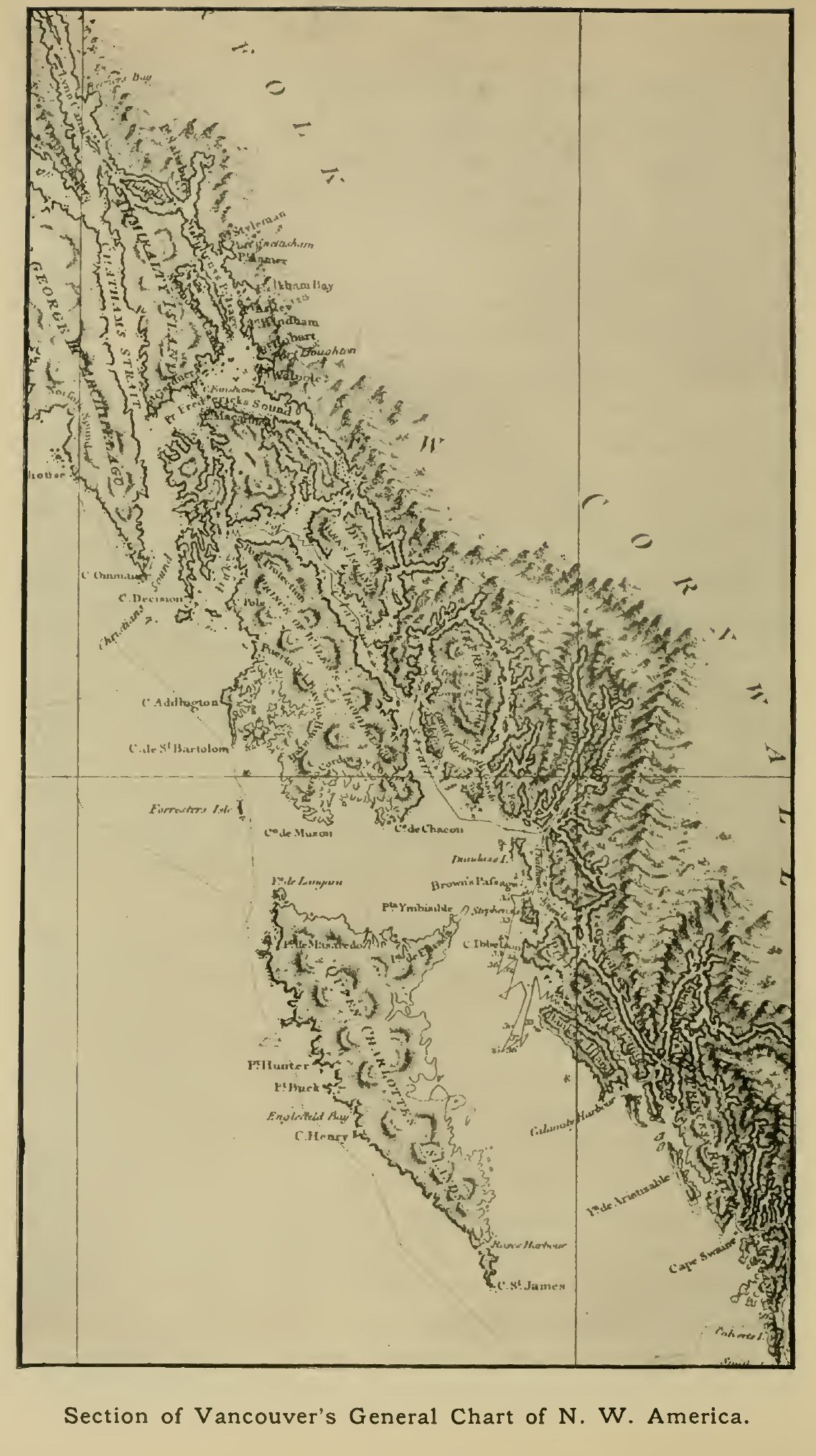
Section of Vancouver's General Chart of N.W. America.
Click on the map to enlarge it.
It is unnecessary to describe in detail the surveys by which the rest of this intricate coast-line was accurately mapped down to the point at which the work had ceased in 1793. On reaching Port Mulgrave (Yakutat bay) Vancouver found that Puget had finished the examination of the coast up to and including this inlet, which was pronounced to be almost certainly identical with the bay visited by Bering, whose name Vancouver therefore applied to it; the supposed bay further west, called Bering Bay by Cook, having proved non-existent.[1] During the whole voyage down the coast the majestic range of snowy mountains made a great impression on the navigators, and Vancouver correctly concluded that it formed a continuous barrier, precluding the possibility of a water-passage into the interior of the continent. On reaching Cross Sound, the northern entrance to the labyrinth of channels partly explored in the previous seasons, Mr Whidbey was once more sent on a boat expedition, which led him north to the head of Lynn Canal (so named by Vancouver from his birthplace in Norfolk), and south almost to Cape Decision, reached in 1793. The work was rendered arduous by cold and wet weather, and some of the natives also proved hostile. At the end of a fortnight—the period for which the party had been provisioned—it became imperative to return to the ship, leaving some of the more eastern channels to be explored later. The ships therefore sailed south along the outer coast as far as Cape Ommaney, which forms with Cape Decision the southern entrance to the waters lately explored, and had been examined and named a few years previously by Colnett. A secure harbour was found on the inner side of the island terminated by this cape, and hence the last remaining inlets were surveyed by boat parties under Whidbey and Johnstone. On effecting a fortunate meeting on the conclusion of their work, these officers marked the successful termination of the task by formally proclaiming British sovereignty over all the coasts and islands examined.[2] Their return to the ships, some time after the date to which the parties had been provisioned, relieved Vancouver of much anxiety, and the happy occasion was celebrated in fitting fashion by the whole of the crews.
[1 The late Prof. G. Davidson, however, who closely studied the question of the course sailed by Bering, did not suppose that he visited Yakutat Bay.]
[2 This did not avail, however, in the sequel, to secure the more northern part of the coast region, now part of Alaska, for Great Britain.]
The geographical work of the expedition was now accomplished. With great determination and perseverance Vancouver had completed perhaps the most arduous survey that it had fallen to any navigator to undertake, and this in spite of serious ill health during the latter part of the voyage. He now directed his course to Nootka—still keeping an eye, en route, to the improvement of the map, whenever possible—and on arrival learnt of the death of his friend Quadra, and of the appointment, as governor, of Brigadier-General José Alava, who had arrived only the day before, but was still without the requisite authority for the settlement of the pending questions. Vancouver occupied the time until the middle of October in refitting the ships, carrying out astronomical observations to serve as a check on the recent survey, and in a visit to the chief Maquinna. He then determined to sail southward, and after touching at Monterey and one or two points off the coast of Lower California, made his way to Chile by the Galapagos Islands, still putting additional touches to his astronomical work. In May, 1795, the voyage was resumed, Cape Horn being rounded (at some distance) in stormy weather, and St Helena reached after a brief and ineffectual search for the supposed Ilha Grande in 45° S. At St Helena the day which had been gained during the eastward passage round the world was dropped. War was now in progress between Great Britain and France and Holland, and Vancouver was able to give some slight assistance to the expedition then being organised against the Cape. The Chatham, which had arrived late at St Helena after a trying voyage, was sent with despatches to the coast of Brazil and made her way home thence, while the Discovery sailed direct in company with a convoy, reaching the Shannon in safety on September 12, and the Thames on October 20, 1795. Only one man of her crew had died of disease during the 4½ years the voyage had lasted, though five had been lost by accident; while the Chatham had lost not a single man during the same period.
Vancouver did not long survive the completion of his important task, but after writing the official narrative of the voyage, died in May, 1798, at the early age of 40, while on a visit to Richmond in Surrey, and was buried in Petersham Churchyard.
One more English voyage to the Northern Pacific, which may be regarded as in some way an outcome of Vancouver's great achievement, remains to be spoken of in this chapter. It was carried out by Captain W.R. Broughton, who, as will be remembered, had commanded the Chatham during the early part of Vancouver's voyage, and had only relinquished his post in order to carry home his leader's despatches. Anxious to further distinguish himself, he applied for a new command, and was sent out in the Providence sloop to complete the outline of the North Pacific coasts by surveys on the Asiatic side, where much remained to be done in spite of the good work performed by La Pérouse. His first lieutenant was Zachary Mudge, who had also been with Vancouver. The Providence, which had lately returned from a voyage to the West Indies under Captain Bligh (see p. 314, infra), was fitted out with every requisite, and sailed from Plymouth Sound in February, 1795, in company, at starting, with a convoy of merchantmen.
After touching at Rio, Broughton decided to take the eastward route viâ Van Diemen's Land and New Holland. He endeavoured, on the way, to fix the position of Gough Island in the South Atlantic, but was hindered by bad weather. Nootka Sound having been reached by way of Tahiti and the Sandwich Islands on March 17, 1796, intelligence was obtained of Vancouver's departure for England more than 15 months before. At length, early in August, 1796, Broughton sailed from the Sandwich Islands for Japan to begin the serious part of his task. His plan was to keep to the latitude of 28½° N., thereby crossing an unvisited part of the ocean, but though a look-out was kept for reported islands, none was discovered. After losing her sails in a gale, the Providence sighted Japan on September 7, a little south of the strait between the main island and Yezo, called by Broughton the Straits of Matsmai or Sangaar (Tsugaru), the name Insu being applied by him to Yezo. The outline and true character of this island was still largely a matter of conjecture, though, apart from the Dutch voyage of Vries with the Kastrikom and Breskens in the seventeenth century, its coasts had been touched at various points both by La Pérouse and by the Russian Spangberg earlier in the eighteenth century.
Crossing the entrance to the strait, Broughton examined Volcano Bay on its northern side, coming across natives who were found to be in strict subjection to the Japanese. He then followed the east coast of Yezo and touched at several of the Kuriles before turning south again, on the approach of winter, in about 48° 50' N. Rough weather making it impossible to pass through the Strait of Sangaar, he went south along the east coast of Japan (getting a good view of Mount Fujiyama), and after passing down the outer side of the Liu-kiu group, reached Macao on December 13, 1796. During the 22 months' absence from England only one man had so far been lost by sickness.
Some time was now spent in preparing for the resumption of exploration towards the north in 1797, and a schooner was purchased and made ready to accompany the Providence. A new start was made in April, and after some delay Formosa was passed and the vessels skirted the south-west portion of the Liu-kiu group, keeping this time on the inner or northern side. Several islands had been passed when, on May 17, the Providence struck on a coral reef, and, the wind freshening, the situation quickly became so serious that it was necessary to take to the boats. All reached the schooner in safety, though with the loss of everything they possessed. The ship now became a total wreck and few stores could be saved, but the condition of the crew was alleviated somewhat by the ungrudging hospitality of the natives of Taipinsan Island. It was now necessary to return to Macao for supplies to permit a continuance of the voyage in the schooner. When the start was once more made the season was so far advanced as to give no great hopes of accomplishing much, and considering this and other disadvantages, the amount that was done was most praiseworthy. Running north along the outer coast of Nippon, the schooner refitted at Endermo in Southern Yezo, and then passed through the Strait of Sangaar to the town of Matsumai. Passing the western entrance to La Pérouse Strait, Broughton coasted the island of Sakhalin to nearly 52° N., but, like La Pérouse, turned south without traversing the narrowest part of the strait between it and the mainland, or reaching the mouth of the Amur. Returning south, he followed the mainland coast, with few intermissions, to the southern extremity of Korea, thus filling in some parts that had been missed by La Pérouse. Few natives were seen until, after approaching the island of Tsusima, the schooner crossed the channel since known by Broughton's name to the port of Chosan on the Korean coast, where some intercourse was had with the inhabitants. After passing through a cluster of small islands Quelpart was visited and its coasts partially examined. Hence the schooner cruised westward, but was prevented by thick weather and adverse winds from making the coast of China or Korea. Broughton therefore gave up all attempt at further discovery and made his way once more to Macao (November 27, 1797). He did not finally reach England till February, 1799.
With the voyages described in this chapter, the period of pioneer exploration in the Northern Pacific may be said to have closed.
{Page 302}
While the work of Cook had thus been actively followed up in the Northern Pacific, it led to no less immediate and important results in the southern parts of the same ocean. Here, too, the objects in view were rather economic than purely geographical, but in their prosecution fresh light was incidentally shed on the seas and lands of that remote region. In 1786 a step destined to lead to the most far-reaching results was taken in the decision of the British government to found a penal settlement on the east coast of Australia; Botany Bay, one of the points at which Cook and his companions had landed during the first exploration of this coast, being selected as its site. The command of the expedition equipped for this object was given to Captain Arthur Phillip, an officer who had seen a good deal of naval service during the late war with France, who sailed with a small fleet of transports and store-ships, supported by two armed vessels, in March, 1787. Among his subordinates, several of whom did useful geographical work in the course of their duties, were Captain John Hunter (who commanded the frigate Sirius), Lieuts. Ball, King, and Shortland (the first in command of the armed tender Supply), and Captains Marshall and Gilbert, in charge of two of the transports. After touching at the Canaries, Rio, and the Cape, Governor Phillip went forward in the Supply, and sighted the coast of New South Wales on January 3, 1788, Botany Bay being reached on the 18th. After the whole fleet had arrived, an examination was made of the neighbouring inlet of Port Jackson, which was found to possess great advantages over Botany Bay, and was therefore chosen as the site of the settlement. Among the many minor indentations of this wonderful harbour the choice fell on one on the southern shore, which received the name Sydney Cove, and on which arose in time the city of Sydney. A thorough survey was made of the ramifications of Port Jackson, and something was done as opportunity offered to examine the region around, though no great extent of country was covered by the earliest expeditions undertaken with this object.
The governor soon decided to form a subsidiary settlement on Norfolk Island—a solitary point of land discovered by Cook in the ocean to the east—with a view to the cultivation of flax and other crops. He entrusted the founding of this settlement to Lieutenant Philip Gidley King, who with a party of marines and convicts was conveyed thither by Lieutenant Ball in the Supply. The latter discovered en route the small, but high and rocky, uninhabited island to which he gave the name of Lord Howe. It was examined more carefully on the return voyage. Meanwhile the transports had landed their stores, and preparations began to be made for their departure. The first to sail (May 5, 1788) was the Lady Penrhyn, Captain Lever, which had on board Lieutenant Watts—an old officer of Cook's—to whom we owe a short account of the voyage. An easterly route was at first adopted, and it led to the discovery, on May 31, of the small volcanic islands of Curtis and Macaulay of the Kermadec group (so named a year or two later by D'Entrecasteaux), a landing being effected on Macaulay—the larger—in spite of the precipitous cliffs which surround it. Before Tahiti could be reached scurvy had reduced the crew to a nearly helpless condition, but the refreshments there obtained soon improved matters. A friendly welcome was received from Cook's old friends Otoo and Oedidee, but news was obtained of the death of Omai. On the further voyage to Macao a low flat island was discovered some distance north of the Society group, which under the name Penrhyn still records the name of the ship. The Scarborough, Captain Marshall, left Port Jackson only a day later than the Lady Penrhyn (May 6, 1788), her destination being likewise Macao. After touching at Lord Howe Island, Marshall was joined by Captain Gilbert in the Charlotte, and most of the voyage was made in company. After passing Norfolk Island, and sighting a small rocky island (Matthew's Island) in 22° 22' S., 170° 41' E., the voyagers traversed the little-known part of the Pacific occupied by the groups of small islands to which their names have since been attached. A number of these islands, which were found to rise abruptly out of a deep sea, were sighted and named, among them Lord Mulgrave's Islands towards the south end of the Marshall group. The natives were as a rule shy, and little intercourse was had with them. Finally, after passing Saypan and Tinian in the Ladrones, the ships reached Macao roads on September 7, 1788.
Early in July four of the transports were got ready to return to England, Lieutenant John Shortland, who had sailed as agent for the transports, being placed in command of the Alexander, and entrusted with despatches for the Home government. Only one of the other ships—the Friendship—kept company with the Alexander, these two making the voyage by a new route to the north of New Guinea, which led to some geographical discoveries. The ships were ill prepared for the difficulties of the voyage, having no surgeon on board, nor any means of combating disease, which in course of time played havoc with the crews. After passing and naming Middleton Shoal, Shortland lighted on a high island with a remarkable peak, which he named Sir Charles Middleton's Island. Continuing to sail nearly due north, he sighted land on July 31, and coasted along it to the north-west. It was a part of San Cristobal, the most southerly of the main islands of the Solomon Islands, the geography of which group was still very imperfectly known. Shortland pursued his voyage along its southern border, sighting land repeatedly and believing it to form one continuous island, to which he gave the name New Georgia—a name still retained for the central cluster of the southern chain of islands, which had been till then practically unknown, and which has been very imperfectly charted down to the present day. While passing along the south coast of Guadalcanar he had sighted the high peak, his name for which—Mount Lammas—is still retained, as are also those given during this voyage to many of the prominent headlands of the several islands. Shortland had failed to find the passages between the more eastern islands, supposing them to be merely lowlands intervening between the higher lands visible, although at two points he had felt some doubt as to the continuity of the land-mass. After passing the westernmost of the New Georgia group—where friendly natives were met with, who called their land Simbu—he was successful in his endeavour to push north, making his way through the strait between Choiseul and Bougainville Islands already discovered by the French navigator Bougainville. While passing through this strait, to which his name is sometimes given, Shortland kept to the eastern side, but sighted the various small islands which block its western half, giving them the name Treasury Islands, though the largest (Alu), with its immediate satellites, is now generally known as Shortland.
Misfortunes now began, scurvy making its appearance, and, in the absence of fresh provisions and other remedies, running its course unchecked. At the Pelew group a first attempt to obtain supplies was unsuccessful, but the commander hesitated to delay the voyage further, thus losing an opportunity which he had deep cause to regret. The crews became more and more enfeebled, and after the ships had narrowly escaped disaster among the reefs and currents between Mindanao and Borneo it was found necessary to evacuate and sink the Friendship. At Batavia help was obtained from the Dutch, but on resuming the voyage only four of the original crews were capable of duty. The Alexander reached the Cape on February 18, 1789, and Shortland found Captain Hunter there in the Sirius. He also learnt that the two other transports had made the voyage by the southern route, and had been heard of at Rio. England was finally reached on May 28, 1789.

The island groups of the Western Pacific.
Click on the map to enlarge it.
The voyages of Captain John Hunter, commander of the frigate Sirius, also deserve mention. On October 2, 1788, he sailed to the Cape for supplies by the Cape Horn route, making a vain search on the way for the island of Diego Ramirez, supposed to lie to the south-south-west of Cape Horn. Returning to Port Jackson in 1789 he carried out surveys of Broken Bay, Botany Bay, and other parts of the coast of New South Wales, also making a voyage to Norfolk Island, where the Sirius was unfortunately lost, early in 1790. On March 27, 1791, he sailed for Batavia in the Waaksamheyd transport, taking, like Shortland, a route to the north of New Guinea, which resulted in some few gains to geography. After sighting the Isle of Pines, at the south end of New Caledonia, and escaping with difficulty from the dangerous reefs in its neighbourhood, he held on a course calculated to take him to the east of the Solomon Islands, between these and the Queen Charlotte group. No trace of the latter could be seen, and Hunter concluded that it must lie further east than had been shown on the charts. On May 10, in 8° 27' S., 163° 18' E. according to his observations, he came upon five small islands, well covered with trees, which he named Stewart's Islands, correctly judging by their position that they must be distinct from Carteret's Islands, though in the same latitude. On May 14 an archipelago of small islands was reached, 32 being visible from the masthead. The natives had canoes with triangular sails. This group, along the southern side of which Hunter sailed, received the name of Lord Howe—an instance of the inconvenient way in which names were duplicated by the sailors of this period, the island between Australia and Norfolk Island having received the same name only three years before. It was the same group as that named Ontong Java by Tasman. Passing other islands, probably identical with some of those seen by Carteret, Shortland and others. Hunter approached New Ireland, and, after many difficulties caused by calms and currents, landed at Duke of York's Island for the purpose of obtaining water. An attack by the natives was followed by a reconciliation, and after passing the Admiralty group and a double island to which Hunter gave the name of his chief (Phillip Island), the voyage was continued through the Malay Archipelago, Batavia being reached on September 27, 1791. Thence, after purchasing the Waaksamheyd from the Dutch authorities. Hunter continued the voyage to England, which was reached on April 22, 1792.
Meanwhile, the voyage to Batavia had also been made by Lieutenant Ball, in the Supply; Lieutenant King, who had been ordered to return to England with despatches, taking passage with him so far. During the voyage, which was begun in April, 1790, Ball was able to add a few additional features to the chart. A shoal was found in 21° 24' S., and was named Booby Shoal, from the stupidity of the look-out man in taking it for the reflection of the setting sun, though bearing east. On May 3, when nearing the position in which Shortland had found land, birds and floating trees were seen, and on the morning of the 5th land was sighted stretching from north-north-west to west-north-west. It proved to be the eastern part of the Solomon group, and a small island at its extremity was named Sirius Island. The land, which was high and well wooded, was kept in view for several days, but at a distance too great to allow the several islands to be distinguished. Like Shortland, who had followed a parallel route on the south-west side of the group, Ball seems to have regarded the land seen as forming one continuous mass, to the north-east coast of which he gave the name Ball's Maiden Land. On the 19th an inhabited island (Tench's Island) was met with in 1° 39' S., 150° 31' E. The naked, copper-coloured natives were remarkably stout and healthy. A little later another island was reached, and it was named, at King's suggestion, Prince William Henry Island, after the third son of George III (afterwards William IV), though better known by Dampier's name, St Matthias. A high mountain in its centre received the name Mount Phillip. The voyage through the Archipelago led past the islands of Karkelang and Karkarolang, through the passage between Gilolo and Celebes and the Strait of Salayer, and so to Batavia. Here King secured a passage home in the Dutch ship Snellheid, but his experiences were far from pleasant, a malignant fever breaking out among the crew and causing many deaths. Ball sailed home by the Cape Horn route in November, 1791, having on board a live kangaroo—the first which any navigator had attempted to take to England. The voyage was more fortunate than others, being finished in a shorter time than any yet made by the Cape Horn route; but it did not result in any new discoveries.
These various voyages, though not individually of the first importance from the geographical point of view, had, in the aggregate, results far from insignificant. Of these, the traverse by Marshall and Gilbert of the hitherto almost unknown portion of Micronesia which now bears their names, and the additions to the knowledge of the Solomon group made by Shortland, were no doubt the most important.
Voyages to the South Seas now followed in such quick succession that many of them can be only briefly mentioned. Another project of the British government which, though of minor importance, led incidentally to the addition of various small islands to the map, was that of the introduction of the bread-fruit tree into the West Indian colonies. Three separate voyages were made in connection with this scheme, and they were to a large extent simultaneous with the Australian voyages above described. At the instance of various merchants and planters interested in the British West Indian Islands, a ship was fitted out during the latter half of 1787, Sir Joseph Banks warmly aiding with his experienced advice. It was named the Bounty, and placed under the command of Lieutenant William Bligh, another of Cook's old officers, who in course of time acquired a good deal of notoriety in connection with the settlement of New South Wales. He was an energetic and capable officer, but somewhat overbearing and not always happy in his relations with his subordinates. This first voyage for the transport of the breadfruit tree was notable chiefly for the mutiny among the crew, which frustrated its object and entailed some harrowing experiences on the commander and those who stood by him. The voyage was to have been made by the Cape Horn route, but the tempestuous weather experienced in the neighbourhood of that cape determined Bligh to bear away for the Cape of Good Hope, whence the voyage to Tahiti was completed by way of St Paul Island (in the Indian Ocean) and Van Diemen's Land. Beyond the latter the Bounty took the route to the south of New Zealand, lighting upon the group of islets and rocks which have since borne the ship's name.
A long stay was made at Tahiti and a large number of breadfruit trees were procured, after which, in accordance with Bligh's instructions, the Bounty sailed for Java. In the north of the Cook or Hervey group the island of Aitutaki was discovered, but though the natives were friendly no stay was made, as Bligh had decided to put in for refreshments at Anamuka in the Friendly group. It was shortly after leaving the latter island that the mutiny broke out, without the least warning, the ringleader being Fletcher Christian, one of the master's mates. Its main motive seems to have been the desire to enjoy a life of ease in one of the island paradises of the South Seas.[1] Bligh and 18 others (including the master, surgeon, gunner, boatswain, etc.) were cast adrift in the small ship's launch, with no firearms and but a scanty stock of provisions and water. In this over-laden boat, the unfortunate men made the long and dangerous voyage to Timor in the archipelago, suffering intensely from hunger and thirst. At Tofoa, the first island touched at, they narrowly escaped disaster from a treacherous attack by the natives. Steering without the aid of a chart, they passed various islands in the Fiji group and northern New Hebrides, and at last made the coast of New Holland, by good fortune finding a passage through the Great Barrier Reef in about 13° S. A small island off the coast was named Restoration Island, in allusion both to the date (May 29, 1789) and to the encouragement offered by their progress so far on their journey. Some small relief in the form of oysters, boobies, etc., was obtained during the six days' coasting voyage which followed, and Torres Strait was successfully passed by the channel north of Prince of Wales Island. In spite of increasing weakness from the hardships and starvation undergone, the voyagers sighted Timor on June 12, 41 days after leaving Tofoa, having covered a distance of over 3600 miles. That this was accomplished without the loss of a fife is a striking proof of Bligh's resource and determination. At the Dutch settlement of Kupang they were received with great humanity, and Bligh was able to purchase a small schooner in which the voyage to Batavia, and eventually to England, was successfully carried out. Several of the party succumbed, however, after Kupang had been reached, among them Mr Nelson, the botanist, who had taken part in Cook's last voyage, and while in the Bounty had devoted unremitting attention to the object of the enterprise.
[1 The mutineers, or some of them, settled at Pitcairn Island; which is still peopled by their descendants.]
An indirect result of the same scheme as had occasioned the despatch of the Bounty was the voyage of the Pandora, Captain Edwards, in 1790-92. This was undertaken partly with a view to bringing the mutineers to justice, and partly for the purpose of effecting a survey of Endeavour Strait, between the northern point of Queensland and Prince of Wales Island, in the interest of navigation to Botany Bay. It likewise proved unfortunate, though some discoveries were made. Cape Horn was successfully passed, and after sighting Easter Island on March 4, 1791, Edwards discovered some small islands in the Low Archipelago, which were named respectively Ducie, Lord Hood, and Carysfort. The two latter have been identified with those known by the native names of Marutea and Tureia.
After a considerable stay at Tahiti, during which some of the mutineers were captured, the Pandora resumed the voyage in the direction of Endeavour Strait, touching at other islands of the Society group and making a search for traces of the Bounty's men at Aitutaki (May 19) and the Palmerston Islands (May 22). At the latter the jolly-boat and her crew were lost, and all search proved unavailing. In his further search for the missing mutineers, Edwards now cruised over a considerable extent of latitude, geography thus benefiting by the discovery of several new islands. Steering at first north-west, he lighted (June 6) on one of the islands of the Tokelau or Union group, which he named Duke of York Island, though it seems to have been identical with Atafu, discovered by Byron in 1765. Turning south he next touched at Nukunono, which he named Duke of Clarence Island, and passing rapidly through the Samoa or Navigators' Islands made his way to Namuka in the Friendly group. Further cruises took the Pandora north, past various northern islands of this same archipelago, to Tutuila of the Samoan group (where the ship's tender unfortunately parted company and could not be found in spite of a careful search), and south as far as Pylstaart in 22°23'S.
Resuming his voyage to the west, Edwards discovered Onooafow (Niuafu), which he named Proby's Island, and after touching at Wallis Island, in 13° 22' S., 176° 15' 45" W., came upon the hitherto undiscovered island of Rotumah, which he christened Grenville, though the native name has since held its own. It was well peopled and the hills were cultivated to the top, but the inhabitants, who were perfectly ignorant of firearms, showed some inclination to hostility, and were great thieves. They are described as uncommonly athletic and strong. A dangerous coral reef in 171° 52' E. received the name of the ship, while a little further to the north-west the islands of Fataka and Anuda were discovered, and named respectively Mitre and Cherry—the latter after the Commissioner of the Victualling Office, in gratitude for the various luxuries provided by him. Another island, to which the name Pitt was applied, seems to have been Vanikoro in the Santa Cruz group, the scene of the shipwreck of La Pérouse, though, as no landing was effected, no light was thrown on this still mysterious catastrophe. Having reached the dangerous neighbourhood of Endeavour and Torres Straits, the Pandora became involved in the reefs, and, striking, at once began to fill rapidly. A night of intense anxiety was spent, and the ship went down about dawn, a number of the crew being drowned. The rest saved themselves in the boats, and, after sufferings fully equalling those of Bligh and his men, though somewhat less prolonged, made their way to Timor, where, like their predecessors, they received a warm welcome from the Dutch at Kupang. On reaching Samarang in Java, they had the satisfaction of finding their tender, which had been navigated by the young officer in command, Mr Oliver. The sufferings of her crew had, if possible, exceeded those of the wrecked crew of the Pandora, and it had been necessary, in the absence of a passage, to beat the boat over the reefs in Torres Strait. Meeting with a small Dutch vessel, they were at first taken for the mutineers of the Bounty, and were sent under escort to Samarang, where their true character was satisfactorily established. The survivors of the expedition eventually took passage to Holland, and the Cape, afterwards crossing over to England, where three of the captured mutineers were executed.
In 1791-92 Bligh made his way once more to the Pacific in the Providence sloop, accompanied by a second vessel, the Assistant. He succeeded in conveying a supply of bread-fruit trees to the West Indies, but the voyage was not important from the point of view of discovery. Perhaps the most noteworthy performance in this respect was the survey carried out on the eastern coast of Tasmania just two months before the first visit of the French navigator next to be spoken of. A MS. chart by Lieutenant Bond, one of Bligh's officers, shows that a part at least of the enclosed waters of D'Entrecasteaux Strait was reconnoitred on this occasion.[1]
[1 See Geographical Journal, Vol. XXXVIII., 1911, p. 582, with reproduction of Bond's chart.]
Simultaneously with these English enterprises, the French expedition under Bruni d'Entrecasteaux was busy in the Western Pacific, though with no political aims. As has already been mentioned, its main object was the search for the missing expedition of La Pérouse, whose mysterious disappearance had now given rise to serious concern for his safety. Two ships, named the Recherche and Espérance in reference to the objects of the voyage, were placed at the disposal of D'Entrecasteaux, who sailed from Brest on September 28, 1791. The Espérance was commanded by Huon de Kermadec—who is doubly commemorated in the nomenclature of the South Seas—and various scientific experts also took part in the voyage, among them being the naturalist Labillardière, who eventually wrote a narrative of the voyage, and the hydrographers Rossel and Beautemps-Beaupré, who were concerned respectively with the publication of D'Entrecasteaux's own journal after his unfortunate death, and of the charts of the coasts visited.
On October 13 the ships reached Santa Cruz in Tenerife, some of the naturalists making the ascent of the peak during their stay. The Cape was reached in January, 1792, and here information was obtained to the effect that Capt. Hunter, in his voyage to Batavia after the loss of the Sirius, had seen uniforms of French officers at the Admiralty Islands, north of New Guinea, to which group it was therefore decided to direct the ship's course. The voyage across the Indian Ocean commenced on February 16, but progress was so slow that it became evident that the proposed destination could not be reached by the route to the north of New Holland, and a course was therefore steered for Van Diemen's Land (the modern Tasmania). This course led the ships between the islands of Amsterdam and St Paul, which, as mentioned already, Vancouver had missed on his outward voyage in 1791; the position of the former being determined with a close approach to accuracy. After a passage of 64 days from the Cape the ships reached Van Diemen's Land on April 21, putting by mistake into a bay to the west of Adventure Bay, which seems to have been wrongly identified with the Storm Bay of Tasman.[1] In it an excellent anchorage was discovered, to which the name Port D'Entrecasteaux was given. Here a stay of some length was made, the naturalists employing the time to advantage by excursions into the country. The enormous size of the gum trees (Eucalyptus) made a great impression, and specimens of the black swan and kangaroo were seen and some natives encountered. Surveys of the coasts revealed the existence of a strait leading east, and affording an interior passage towards Adventure Bay, and this was successfully navigated by the ships. It, too, received the name of the commander, who was also commemorated in the name Bruni given to the island which it separates from the mainland.
[1 In the charts accompanying the official narrative of the voyage, published some years later, the name Storm Bay is rightly assigned to the large bay east of Adventure Bay.]
Having once more reached the open sea, the voyagers quickly rounded Cape Pillar, and shaped a course for New Caledonia. This island was sighted on June 16. Its south-west coast had not been surveyed, Cook on his second voyage having confined his examination to the opposite side. Like Hunter in the previous year (see p. 306) D'Entrecasteaux and his comrades with difficulty surmounted the dangers of navigation among the reefs which fringe the coast, and which became still more formidable towards the north. The examination of this side of the island was nevertheless successfully carried out, its general form being thus laid down with fair accuracy. The chain of mountains which form its backbone were reckoned to extend about 80 nautical leagues from south-east to north-west. Still hampered by reefs and sighting various small islands, the voyagers approached the strait between Choiseul and Bougainville of the Solomon group, but after passing near the Eddystone rock and Treasury Islands of Shortland held on a course to the south of Bougainville, which was now examined for the first time on this side, as was also the neighbouring island of Buka. Passing through St George's Channel between New Britain and New Ireland, and putting in at Carteret's Harbour, they eventually reached the Admiralty group, which was examined without yielding any traces of the missing voyagers. The natives proved friendly, though here as elsewhere much caution was observed by the visitors. The Hermit and Échiquier groups were next visited, and after sailing along the north coast of New Guinea, the expedition made its way to Amboina to replenish supplies.
After more than a month's stay at Amboina, the productions of which were examined by the naturalists, D'Entrecasteaux once more set sail, making a circuit to the west and south so as to strike the coast of New Holland near its south-west point. The voyage along this coast was to some extent a repetition of that of Vancouver in 1791, but it extended farther to the east, though not sufficiently far to clear up the question of the separation of Van Diemen's Land from New Holland. The ships took refuge from a storm in an anchorage discovered by Legrand, whose name was given to it. Excursions were made on the land and its botany and zoology studied. The roadstead was in the neighbourhood of the archipelago of small islands at which the Dutch discoveries of Pieter Nuyts had terminated, and the French voyagers were surprised to find how accurately that navigator had determined his latitudes on this coast. During a visit to the mainland, one of the naturalists—Riche by name—lost his way and wandered almost without food for more than two days, the search made by his companions being almost abandoned as hopeless.
In their efforts to advance eastward the voyagers were much hindered by easterly winds, and on January 5, 1793, the water-supply having fallen very low, it was decided not to attempt to trace the coast further, but to steer once more for the southern part of Van Diemen's Land. The longitude reached, according to the observations made, was 129° 10' east of Paris, or 131° 30' east of Greenwich. The strength of the current flowing west along the coast led D'Entrecasteaux to conjecture that a channel existed between Van Diemen's Land and New Holland, as was proved to be the case a few years later. On reaching Van Diemen's Land the mountains were found to be much less covered with snow than on the previous visit. An anchorage was found in a bay which received the name Bay of Rocks, and here the ships stayed some time, the voyagers entering into friendly relations with the inhabitants, who, in spite of the coolness of the weather, were almost entirely unclothed. An interesting account of their manners and customs is given by Labillardière. Coal was observed to exist in the neighbouring country. On February 15, the ships set sail in order to pass through D'Entrecasteaux Strait into Adventure Bay, which latter was left on March 1. Passing near the north end of New Zealand, D'Entrecasteaux steered for Tongatabu, discovering several small islands on the way. From the Friendly Islands, where the ships stayed till April, the course was due west to the northern part of New Caledonia. Several of the southern islands of the New Hebrides were sighted en route, and while passing Tanna, pillars of smoke were seen to issue from its volcano, illumined at night by the incandescent matter within the crater.
Some stay was made at New Caledonia, and advantage was taken of this opportunity of making some exploration of the interior of the island, excursions being made into the mountains and a view obtained on one occasion of the sea on the opposite or south-western side. The natives were on the whole friendly, though some collisions occurred and unmistakable signs of their cannibalism were seen. No traces of La Pérouse could be found, nor were the natives in possession of any of the objects presented by Cook, though a trace of his visit was seen in the form of the rusty base of an iron candlestick. Before leaving the island, the expedition had the misfortune to lose the Captain of the Esperance, Huon de Kermadec, who was buried on shore, his place being filled by the promotion of Lieut. Dauribeau of the Recherche.
The ships now sailed nearly north to Santa Cruz, where they met with some hostility on the part of the natives. On May 22, the Volcano Island of Carteret was sighted, but no signs of activity were noticed. Once more steering west, the easternmost of the Solomon group was soon sighted, and after coasting along the small group of the Three Sisters, the ships passed between San Cristobal and Guadalcanar, passing along the south side of the last-named and of New Georgia, and then steering for the Louisiades of Bougainville. This part of the voyage—through the labyrinth of islands east of the east end of New Guinea—was perhaps the most important of all, for this area had been but imperfectly known as a result of Bougainville's voyage, and many new islands were brought to light, the names of several of the officers (Rossel, Joannet, Renard, St Aignan, Trobriand) being still found on our maps as alternative names for islands now sighted, while the group of larger islands nearest to New Guinea bears the name of D'Entrecasteaux himself. The ships were frequently in danger from the many reefs of those seas, but a passage was always found in the end. On May 25, the coast of New Guinea itself was made, and the deep bay which has since borne the name of Huon Gulf in honour of the deceased Captain of the Espérance was entered for the first time. It was bounded, especially to the north, by high mountains, terminating in the Cape King William of Dampier, the western portal of Dampier Strait. Through the eastern branch of this the French voyagers now passed, as had the English navigator to whom it owes its name. But instead of at once taking a westerly course parallel to the north coast of New Guinea, D'Entrecasteaux sailed east along the north coast of New Britain, the approximate form of which he was thus the first to lay down. He did not, however, keep near enough to the land to trace all the indentations of the coast, and left it uncertain whether the group of peaks lying to the north of the main mass were islands or portions of a peninsula—an uncertainty which was not cleared up until a century later. Having reached the north-eastern extremity of the island he steered west for the archipelago, but on August 21 died after only two days' illness, leaving the command to Dauribeau, who, as already mentioned, had been lately made Captain of the Espérance. D'Entrecasteaux had shown himself an energetic and capable commander, and his loss was seriously felt by the survivors. Disease now began to spread among the crews, who were much weakened by it before reaching Java. On arriving at Surabaya in October, 1793, war was found to have broken out between France and Holland, and several prominent members of the expedition were made prisoners of war, Dauribeau having apparently secured favourable terms for himself at the expense of his companions. He died soon after his arrival at Samarang, and after long delays the prisoners (among whom was Labillardière) found their way in 1795 to Mauritius, and thence, a year later, to France.
Although without result as regards the search for La Pérouse, the expedition had made some useful additions to geographical knowledge, and the researches of the naturalists into the little-known productions of the countries visited were of special value. Labillardière's collections, which had been seized and taken to England, were restored to him through the good offices of Sir Joseph Banks.
A voyage which corresponded very closely with the latter part of this of D'Entrecasteaux was that of Captain, afterwards Commodore Sir John, Hayes of the Bombay Marine, who, obtaining leave of absence, persuaded some Calcutta merchants to join him in a venture for the purpose of bringing back nutmegs and other spices from the western parts of New Guinea, thus repeating the project of Captain Forrest, spoken of in Chapter IX. Sailing from Calcutta on February 6, 1793, with two ships—the Duke of Clarence and the Duchess—Hayes found the winds unfavourable for the direct voyage to New Guinea, and he therefore decided, after reaching Timor, to proceed first to Tasmania and thus approach his destination from the east after a wide circuit through the Western Pacific. He was on the Tasmanian coast only a couple of months after D'Entrecasteaux's second visit, of which he was completely ignorant, and his surveys there had been anticipated by the French Admiral as well as by Bligh. The further voyage also led him more or less in the tracks of D'Entrecasteaux. He visited New Caledonia, and ventured closer to land than his predecessor among the dangerous reefs which fringe the south-west coast. Thence he sailed north-west, and reached the Louisiade Archipelago, cruising in various directions among these islands. Here he seems to have been in advance of his French rival, and was the first white man to land on Rossel Island, which D'Entrecasteaux merely named in passing. Reaching the scene of the proposed commercial enterprise, he found the nutmeg and other spice-producing trees growing as he had expected, and he built a fort on which he hoisted the British flag, taking possession of the country under the name New Albion. He then sailed for Calcutta, but failing to obtain support, was obliged to abandon the scheme. The journal which he kept during the voyage was never published, though it still exists in manuscript.
Voyages to the Pacific had now become a matter of yearly occurrence, and although small islands, previously unvisited, continued to be brought to light, the discoveries were not of sufficient importance to call for a description of each separate voyage. A few of those to which the discovery and naming of such islands were due may, however, be briefly mentioned. In 1793, Capt. James Mortlock added to the map the small group in the Caroline Archipelago which still bears his name. Captain Butler, who made several voyages between 1794 and 1803, lighted upon one of the islands of the Loyalty group, which had not been seen by Cook at the time of the discovery of New Caledonia, as well as one or two others in other parts of the Pacific. Captain Fearn (in the Hunter), and the American Captain Fanning, also made some new discoveries, including the small islands which now commemorate their names. In 1796, Captain Wilson, who had already had considerable experience of Pacific navigation, was sent out in the Duff on behalf of a newly-formed missionary society, which had chosen as its field of action Tahiti, the Friendly Islands, Marquesas, Sandwich Islands, and others. In 1797, the Duff reached Tahiti by a route south of Van Diemen's Land and New Zealand, afterwards making several cruises, in the course of which she visited the Marquesas, traversed the Low Archipelago, and from Tongatabu made the voyage to Canton through the Fiji and Caroline groups. Some results were gained in the way of a more precise knowledge of some of the islands visited, especially in the eastern part of the Fiji group, of which, as of the island of Tongatabu, Captain Wilson gave a chart in his published narrative. Although not entirely a new discovery, the small Duff group, to the north of the Santa Cruz Islands, has its name from Wilson's ship.
By the close of the eighteenth century the general outlines of Pacific geography had at last been completed, the last four decades of the century having yielded greater results than the whole time which had previously elapsed since the first track across that ocean had been drawn by Magellan. Future work, in the performance of which such navigators as Lütke, D'Urville, Krusenstern, Wilkes, and others did useful service, consisted chiefly in the filling in of small details. The island continent of Australia was now to form the principal field for pioneering work in the southern hemisphere.
{Page 322}
I. The Great North-west.
We have seen in a former chapter how, under the energetic leadership of men like Champlain and La Salle, the French adventurers in Canada had, during the seventeenth century, pushed steadily westward until the whole region of the Great Lakes, with a large stretch of country to the south, had been brought within their sphere of action; Jesuit missionaries having likewise played no inconsiderable part in the work of exploration. Farther north the still earlier voyages, principally English, to Hudson Bay had revealed the whole outline of that interior sea, though practically no progress had been made towards a knowledge of the vast regions lying inland from its shores. We have now to take up the story and show how, in the course of the eighteenth century, the westward advance was continued until, in the closing years of the century, the boldest pioneers had succeeded in reaching the long-desired goal of the western sea. During the first half of the century the French still bore the burden of the day, the chief advance being effected in the more southern zone, due west from Lake Superior, towards which restless spirits like Greysolon, Sieur Du Lhut (or Du Luth), had begun to push their enterprises, even before the close of the seventeenth century. Some few attempts were made from the northern base on Hudson Bay, by agents of the Hudson Bay Company, but these remained more or less isolated episodes until, after the middle of the century, the competition of their southern rivals showed the company the need of more energetic action. With the transfer of Canada to the English as a result of Wolfe's victorious campaign, the French pioneers disappeared from the scene, and both in the north and south the work was carried on by men of British origin, though displaying for a time a still keener rivalry among themselves than had been maintained between the French and English at an earlier date.
We must go back to the eighties of the seventeenth century for the first beginnings of an advance into the unknown region west of Lake Superior. The Kaministikwia River, which enters that lake on its north-west shore, and at the mouth of which Du Lhut had built a fort, was ascended about 1688 by Jacques de Noyon, who reached the "lake of the Cristinaux", since known as Rainy Lake, and wintered at the mouth of the Uchichig or Rainy River, which enters the lake at its western end. His farther route is somewhat obscure, but he seems to have gone by the Rainy River to the Lake of the Woods, which he knew by the names Lac des Assiniboiles (Assiniboines) or Lac aux lies. It has been held that the Lac des Cristinaux was really the Lake of the Woods, and the farthest lake reached, Winnipeg, but for this belief there hardly seem sufficient grounds. After this, little was done until the second decade of the next century, when, in 1716, the governor De Vaudreuil and the Intendant Begon drew up a report suggesting steps for western discovery. As a result, Lieutenant Zachary de la Noue was sent in 1717 to establish a post on the Kaministikwia River, which he did, possibly also founding a post on Rainy Lake. In 1718, a detailed memoir was drawn up by Father Bobé, in which various possible routes to the west were discussed. Although containing some judicious remarks, many of the ideas put forward in this memoir were quite the reverse. Bobé greatly under-estimated the difficulties to be encountered in the exploration of a route to the Western Ocean, which he thought could be reached with comparative ease. A few years later the historian Charlevoix was sent to make enquiries on the spot, and he also put down his conclusions in a report to the Government. He suggested two possible courses, one to push west by way of the Upper Missouri, the other to establish a mission amongst the Sioux as a base for a farther advance. Though he was himself inclined to favour the first of these plans, the second was adopted, as involving a smaller amount of trouble and expense. With this object, an expedition went, in 1727, across Lake Michigan to Green Bay and by the Fox and Wisconsin rivers to the Missouri, but it was without result as regards western discovery.
About this time, however, there came on the scene a pioneer worthy to be ranked with a La Salle for his whole-hearted devotion to the cause of discovery. This was Pierre Gaultier de Varennes, Sieur de la Vérendrye, generally known to posterity by the last name. Born at Three Rivers in 1685, he went to Europe in search of a more active career than offered itself in Canada, and, entering the French army, fought and was wounded at the battle of Malplaquet. Returning to Canada, he took to the adventurous life of a "courreur des bois", and in 1726 we find him in command of the trading post of Nipigon, on the northern shore of Lake Superior. His thoughts were turned towards western discovery by the reports of an Indian chief, Ochagach by name, who came from Kaministikwia with accounts of a great water that ebbed and flowed, and which La Vérendrye was sanguine enough to take for the Western Ocean, though if the report had any foundation it probably referred to Lake Winnipeg, whose waters have been known to rise and fall locally under the influence of the wind. Fired with the ambition of making his way to this sea, La Vérendrye went to Quebec and submitted a scheme for western discovery to the governor, the Marquis Le Beauharnois. Although personally favourable, all the support the governor could obtain for the would-be explorer was the grant of a trading monopoly, armed with which the latter succeeded in persuading certain merchants of Montreal to supply funds for the venture, and returned to his post to make preparations.
It was in the summer of 1731, that, accompanied by his nephew De la Jemeraye and three of his sons, La Vérendrye started from Grand Portage at the mouth of the Pigeon River, near the west end of Lake Superior, for a first advance westward. In this year he reached Rainy Lake, and after building Fort St Pierre at the Rainy River exit, returned to winter at Kaministikwia. In June, 1732, his party was again at Fort St Pierre, whence the Rainy River was descended to the Lake of the Woods (Minitie or Ministik, meaning really "lake of islands "). Here, on the south-west side of the lake, another fort, Fort St Charles, was built. From this as a base, Jean Baptiste, the explorer's eldest son, descended the Winnipeg River (named Maurepas in honour of the French Minister) to the lake of the same name, being the first who is known with certainty to have reached its shores. La Vérendrye's supplies were now exhausted, and he once more went down to Montreal, where he with difficulty persuaded the merchants to equip a new expedition. Returning to Fort St Charles in 1736, he found the garrison in straits for supplies, while his son arrived from Fort Maurepas—which had been built at the mouth of the Winnipeg River—with the unfortunate news of the death of La Jemeraye. Another disaster soon followed, for his eldest son, Jean Baptiste, having started to meet the supplies, was attacked by Sioux and himself and his whole party massacred. La Vérendrye's other two sons had, however, done some good work in the exploration of Lake Winnipeg, and of the Assiniboine River as far as the site of the future Portage la Prairie, where a new post, Fort la Reine, was soon to serve as a starting point for still more extended journeys. The future highway west of Winnipeg, followed eventually by the Canadian Pacific Railway, was thus already being opened up by slow degrees.
The year 1737 was partly occupied by a journey to Montreal, and it was not until October, 1738, that La Vérendrye found himself able to undertake further explorations, which now took a direction well to the south of west. He then set out, with his two sons and a party of Canadians and Assiniboines, for the country of the Mandans who dwelt on the Upper Missouri, within the modern state of North Dakota. Following an Indian trail across the prairie, the explorers reached on December 3 one of the Mandan villages, whose chief had met them on the way. The 100th meridian west of Greenwich had now been crossed for the first time in this latitude, and considerably more than half the distance between Montreal and the shores of the Pacific had been traversed; but though some farther advance was shortly afterwards made by this route, it was not by it that the Western Ocean was first to be reached.
The desertion of the Assiniboine interpreters prevented the explorers from making satisfactory enquiries of the Mandans, and although it was the depth of winter, La Vérendrye decided to return to his base. His own severe illness, and the freezing winds encountered on the bleak and snow-covered prairie, made the journey one of the most trying imaginable, but by dogged determination the party at length reached Fort la Reine on February 19, 1739. The state of the leader's health put it out of the question for him to continue the task of exploration, which now devolved on his sons. In the autumn of 1739, two men, who had been left with the Mandans, returned with news of the arrival among that tribe of strange Indians who told of bearded white men living by the shores of the sea. La Vérendrye at once sent his son Pierre to renew the attempt in that direction, but he was unable to procure guides at the Mandan villages, and therefore returned unsuccessful.
During the next two years nothing further was attempted, but in 1742 La Vérendrye's two sons set out on what proved to be their most important expedition. Reaching the Mandan villages once more, they waited some time expecting the arrival of Indians from the country in front (spoken of as "Gens des Chevaux"), but being disappointed of this they set out with Mandan guides. Passing the Little Missouri, and noticing the many-coloured earths of that region, they reached the country of the "Beaux Hommes", who seem to have been Indians of the Crow family. Continuing on a south-west course they eventually reached a village of the "Gens de l'Arc" or Bow Indians, and joined a war-party proceeding westward against the dreaded "Snake" Indians. In the company of this party the French explorers came to the foot of a range of mountains with snow-clad peaks, and sides covered with firs and pines. Here they found a deserted camp of their enemies, and suspecting that its recent occupiers were making a raid on their own villages, the "Bows" beat a hasty retreat, much to the chagrin of the Frenchmen, who had hoped to find the ocean on the other side of the mountains. It is not certain how far west the La Vérendryes had penetrated, some historians thinking that they pushed almost to the source of the Missouri, at the foot of the main chain of the Rocky Mountains, others that the Bighorn Mountains, further east and south, formed the limit of the adventurous journey. In any case it was only an isolated episode, and for a number of years no further advance in the same direction took place.
The return journey was made by a somewhat different route. The Missouri was struck either above or below the Mandan villages, to which the travellers then followed its banks. They were once more at their starting-point at Fort St Pierre on July 2, 1743.
Meanwhile some progress had also been made by a more northern route. Before 1738, the La Vérendryes had discovered Lake Manitoba (called on their maps Lac des Prairies), on the shore of which Fort Dauphin was soon afterwards established. Before long one of the sons seems to have reached the Saskatchewan, though no particulars of the journey are known. Before 1749, it had been explored to the junction of the two main branches, while a fort (Fort Bourbon) had been built on its lower course, and another (Fort Paskoia) at the point since known as Le Pas. These several achievements mark the close of the exploring activity of La Vérendrye and his sons. A tardy recognition of the value of their work was forthcoming in the bestowal on the father of the rank of Captain, and his decoration with the Cross of St Louis. But though proposals for a new expedition were entertained and La Vérendrye set about the necessary preparations, the final break-down of his health frustrated his hopes, and he died at the end of the same year (1749). With little outside help or encouragement he had accomplished work which entitles him to be regarded as one of the most meritorious of the pioneers of Western discovery in North America.
After La Vérendrye's death an act of great injustice was committed by the new governor. La Jonquière, who not only refused permission to the explorer's sons to continue their father's work, but made over all their posts and effects to one Jacques de St Pierre, who was ordered to continue the search for a way to the west. In 1750 he started for Fort la Reine, and sent on the Chevalier de Niverville to continue the exploration of the Saskatchewan. The journey was made in winter, and the upper fort on the Saskatchewan was reached with great difficulty. In the spring of 1751 De Niverville, being himself ill, sent on some of his men to ascend the Saskatchewan beyond the La Vérendryes' farthest, and they are said to have reached a spot not far from the Rocky Mountains, and to have built a fort. Opinions differ as to whether this was on the North or the South Saskatchewan, but the probability seems slightly in favour of the latter. At this fort, which was named after La Jonquière, accounts were given by the Indians of white men living on an island near the west coast, with whom trade was carried on, but it is doubtful whether these had any real foundation.
This was the only exploring achievement effected during the term of office of St Pierre, who seems to have been injudicious in his dealings with the Indians, making them little disposed to aid in the task. His successor, De la Corne, also did little or nothing, and no further progress had been made when the cession of Canada to Great Britain in 1763, as a result of Wolfe's victorious campaign, changed the whole course of future exploration in this region.
Before continuing the story of the advance by this southern route, it will be necessary to consider briefly the progress made by British explorers towards a better knowledge of the interior from the base afforded by Hudson Bay, where, it will be remembered, the agents of the Hudson Bay Company had been at work since the sixties of the seventeenth century; suffering, however, many checks from the aggressions of the French. The first half-century of the Company's existence was marked by practically no step forward from the point of view of exploration, the Company's activity being almost entirely confined to the shores of the bay. A single exception is formed by the journeys of Henry Kellsey, a young man in the service of the Company, who associated himself with the Indians, and in their company ventured some distance into the interior, though much uncertainty exists as to the extent and precise direction of his travels. The most important journey seems to have been made in 1690-92, when he is said to have reached the country of the Assiniboines (whether on his own account or under orders from his superiors is not quite certain), his object being to persuade the Indians of the interior to trade. The probability is that he pushed north-west to the borders of the "Barren Lands", though some have supposed his route to have been rather west or south-west. An interesting fact is his meeting with herds of "buffalo" (properly bison). In any case he was the first to explore any part of the interior from the Hudson Bay base, though the accounts he gave were too vague to be of much practical value, and it was long before this small beginning of exploration was followed up.
Some attempt to explore the coasts of Hudson Bay, with a view to finally settling the question of a sea passage to the west, were made in the first half of the next century, though they led to little more than negative results. In 1719, Captain James Knight, a veteran of nearly 80, had sailed with the Albany and Discovery, in the hope of discovering the long talked of strait of Anian. But he met with disaster at Marble Island, where he wintered, and where the entire expedition died eventually from disease and starvation. Captain Scroggs made a vain search for the lost expedition in 1721-22, and not until 1767 was its fate ascertained by the discovery of relics at Marble Island. While the Company appears to have been lukewarm in its efforts to find a passage, an energetic advocate of more vigorous action appeared in the person of Arthur Dobbs, a fierce critic of the Company's methods, who, in 1741, after agitating for some years, persuaded the British Admiralty to fit out an expedition, which was placed under the command of Captain Christopher Middleton. Sailing with the Furnace and Discovery, Middleton reached Churchill in September, 1741, and started for the north in July, 1742. He discovered Roe's Welcome, Wager Bay, Repulse Bay, and Frozen Strait, but proved that no passage to the west led out of this part of Hudson Bay. He landed to the south of Cape Frigid, on an island which he took to be part of Southampton Island, but which has since proved to be separate. This voyage was valuable as bringing to light the largest previously unknown portion of the western shores of the bay, and so completing the work of Bylot, Foxe, and James, more than a century earlier. A still later voyage, carried out by Captain Charles Duncan in 1790, had no result of importance.[1]
[1 For Duncan's work on this coast in 1791-2 see Appendix.]
It was not until after the middle of the eighteenth century that the first journey of real importance into the interior west of Hudson Bay was made. It was carried out by Anthony Hendry, of whose earlier history, as in the case of so many of the successful adventurers of the time, little is now known. It appears that he had been outlawed in 1748 for smuggling, but only six years later we find him sufficiently trusted by the Hudson Bay Company to be employed as leader of the important expedition now to be described. In June, 1754, he left York Factory for the interior with a party of Indians. His route has not been ascertained with certainty, but in the opinion of the most competent writers it was probably as follows. Ascending first the Hayes, and then the Steel River, Hendry entered the woods, and after effecting various portages necessitated by rapids and shallows, reached a lake which he spoke of as Deer Lake, but which seems to have been that now known as Oxford. Hence he reached a lake which he called Christianaux, but which can hardly be Winnipeg, to which the French had previously applied that name; the route taken being probably that by Cross Lake, Pine River, and Moose Lake to the Saskatchewan, which river Hendry was the first Englishman to set eyes on. He ascended it to one of the forts already established by the French, the officer in charge of which, though polite, was inclined to oppose his advance. But he did not venture to use force, and Hendry continued his journey to the south-west, passing Saskeran Lake and Carrot River. Leaving his canoe, he struck out across the plains—finding plenty of game, and coming in touch with the Assiniboines—and for the first time explored the country between the north and south branches of the Saskatchewan.
Going south-west across the Pasquia hills, on August 15, Hendry came upon the first "buffalo." Touching first the South and afterwards the North Saskatchewan, he advanced over a pleasant country, abounding in game, and early in September met with a party of Indians, whom he names Archithinue, but who without doubt belonged to the tribe afterwards widely known as the Blackfeet, with whom he was soon to form an intimate acquaintance. On October 11 he crossed a river, which seems to have been the Red Deer, and three days later came up with the main body of the Blackfeet. On November 21 he reached his farthest west, probably not far short of 114° W. and a little south of 52° N. Hendry spent the winter in the Blackfeet country, travelling in various directions, and pushing north as far as Devil's Pine Lake. On April 28, 1755, he embarked on the Red Deer river, and began his homeward journey. The French fort below the forks of the Saskatchewan was passed, as well as that visited the year before, and, keeping to the route followed in the outward journey, Hendry reached York Fort in safety on June 20, 1755, having performed a most creditable piece of work.
Thus even before the British conquest of Canada, an English explorer had equalled, if not outdone, the French in western discovery, and though for a few years the latter continued their westward advance, it was under the new political régime that the great object of ambition, the attainment of the western ocean, was at last achieved. It was to the agents of the future North-West Company, the great rival of the Hudson Bay Company, that most of the honours subsequently fell, but some later journeys by agents of the older company may here be spoken of.
The first in point of time, that of Samuel Hearne in 1770, covered a different field, far to the north, and before speaking of this another journey in the basin of the Saskatchewan, carried out by Matthew Cocking in 1772, must be mentioned, as it was in many ways a counterpart of that of Hendry. Cocking was "second factor" under the Hudson Bay Company at Fort York, and the object of the journey was "to take a view of the inland country, and to promote the Hudson Bay Company's interests, whose trade is diminishing by the Canadians yearly intercepting natives on their way to the settlements." (This refers to the activity of the British traders from Montreal, to be spoken of later.) Cocking started on June 27, 1772, and, ascending the Hayes River, made his way by various other rivers and portages, including part of the Nelson River, to the lower Saskatchewan; his route probably differing somewhat, though to no great extent, from that of Hendry. From a point near the French Fort à la Corne he went south-west, again by a different route from Hendry's, into the country between the north and south branches of the Saskatchewan. His farthest was by no means so remote as Hendry's, for he seems to have turned before reaching 110° W., making his way back to Fort a la Corne by a route somewhat to the north of his outward one. He added considerably to the knowledge of the country within the two branches of the Saskatchewan (which he found already being overrun by rival traders from Canada) and saw a good deal of the Blackfeet Indians, of whom he has much to tell in his journal. But he can hardly rank among the great explorers of Canada, either French or English.
Samuel Hearne, the explorer of the north referred to in the last paragraph, was perhaps the most meritorious, as he is the best known, of all the agents of the Hudson Bay Company who devoted themselves to the task of exploration before the amalgamation of that company with its great rival, the North-West Company, in the early part of the nineteenth century. Again we have to be content with somewhat meagre details regarding his earlier career, and we only know that, having been left an orphan at an early age, he entered the navy as a midshipman under the future Lord Hood, but after a few years left the service and obtained employment under the Hudson Bay Company, serving as mate in a schooner trading with the Eskimo on the shores of the bay. It is in 1769 that he first comes on the scene as an explorer, being then commissioned to go north-west in search of a river spoken of by the natives as flowing through a country abounding in copper ore, while he was also instructed to aim at a solution of the question of a passage westward out of Hudson Bay. Attempts in the same direction may possibly have been made before, for we know that tales of rich copper mines had engaged the attention of the Company's officers for some time, and the Indians of the north-west are said to have been visited before Hearne's time, both by Richard and by Moses Norton, the latter of whom, as governor of Fort Prince of Wales, near the mouth of the Churchill, was largely instrumental in sending Hearne on his present quest.
The explorer started on his first journey on November 6, 1769, with two Englishmen and a party of Indians, but before long the latter began to give trouble, and eventually deserted, so that Hearne was forced to return. He soon set out again (February 23, 1770), this time with five Indians only, going west up Seal River to Lake Shethani, where he waited till the rigour of winter should be past. Starting again, he turned north, and on June 30 reached the Kathawachaga or Kazan river, at a spot which he placed in 63° 4' N., but which seems to have really been more than a degree further south. By the end of July he seems to have reached the north end of Dubawnt Lake, but, having the misfortune to break his quadrant on August 11, decided to return. Travelling by a somewhat different route, he once more reached Fort Prince of Wales on November 25, the journey having been a failure as regards its main objects, though a certain amount of new ground had been covered.
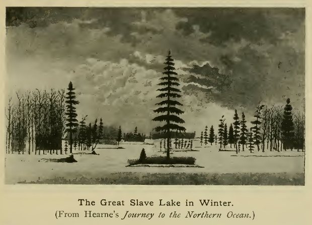
The Great Slave Lake in Winter.
(From Hearne's Journey to the Northern Ocean.)
During the return march Hearne had been joined by an Indian chief, Matonabi, who gave as one cause of his failure the omission to take the wives of the Indians to help with the transport, etc. It was therefore arranged that this chief and his followers, with their women, should accompany the explorer on a third venture, and a renewed start was made on December 7, 1770. A more southerly route than had been followed earlier in the year brought the explorer to Nueltin or Bland Lake on December 31, and on February 6, 1771, the Kazan was once more crossed. In May the party was joined by a band of Chipewyans, bent on attacking the Eskimo of the country to the north, and the rate of progress was increased by leaving behind the women and the heavier baggage. Journeying north, and crossing the Arctic circle, the party encountered the Copper Indians towards the end of June, and reached the Coppermine river on July 13, pushing on to its mouth on the 18th, after a heartless massacre of the Eskimo had been perpetrated—without Hearne's connivance—by the Indian allies. The Arctic Ocean had for the first time been reached in this quarter of the globe.
The position assigned by Hearne to the mouth of the river (nearly 72° N.)is something like 4° too far north, and his mapping generally seems to have been loose and inaccurate, but he had performed a notable exploit in traversing so great an extent of hitherto unknown country, some of which has hardly been visited since his time. His examination of the copper deposits, however, proved very disappointing.
On the return march Hearne adopted a new route, to the west of south, which led him through more new country and resulted in the discovery (December 24, 1771) of one of the great lakes of the Canadian North-West. It is spoken of by him as the Great Athapuscow, and has therefore naturally been identified with Lake Athabasca, though from the general direction of Hearne's route it is practically certain that it was really the Great Slave Lake. After crossing the lake—to which he assigns the fairly correct length of 120 leagues—he ascended the river which enters it from the south for 40 leagues, and then went east, through a country still little known, to the Kazan, and so to Fort Prince of Wales.
It is on this adventurous journey that Hearne's fame mainly rests, but he continued for some time to take an active part in the affairs of the company. Two years later, being sent to form a post inland, he chose a site on Cumberland Lake, just north of the lower Saskatchewan, and there built Cumberland House, long important as a rendezvous of the fur traders. In 1775 he was governor of Fort Prince of Wales, and was in command of this at the time of the hostile descent of La Pérouse in 1782 (see Chapter XI), when, being quite unprepared for resistance, he submitted to the unpleasant necessity of surrendering both the fort and its contents to the French commander. La Pérouse courteously allowed him to keep the journals of his northern journeys, urging him to publish them, which he did after some delay.
From this time onward exploration from the side of Hudson Bay is so interwoven with that from Canada—the two series overlapping both in time and place—that it is not always easy to determine to which side the priority in any particular discovery belongs. After Hearne's journey, the northern company was content to rest on its laurels for some years, while the keen British traders who had succeeded to the heritage of the French in Canada pushed not only west, but north, into the field already to some extent exploited by their rivals. It will therefore be necessary, the better to preserve chronological sequence, to speak of the doings of these southerners during the decades immediately following the English conquest of Canada.
Before anything had yet been achieved by the Canadian traders, an ambitious scheme of exploration had been proposed to himself by an outsider, one Jonathan Carver, of Connecticut, whose idea was to push west to the Pacific from the Upper Mississippi. He started in 1766, and, according to his own statement, ascended the St Pierre (Minnesota) river to the country of the Sioux; but, finding it impossible to advance farther, returned to the Mississippi and thence to Lake Superior, hoping to make his way westward from that base. Unable to obtain supplies, he abandoned the attempt and returned to Boston (October, 1768). He published a volume of travels, illustrated by a map—neither entirely trustworthy—and he cannot be said to have made any important contribution to geographical knowledge.
Among the first British traders to push west from Canada into the region of the Saskatchewan were, according to the scanty indications we possess, James Finlay and Thomas Curry, who were already in the country when Matthew Cocking, the agent of the Hudson Bay Company, made the journey already spoken of. Other traders were Peter Pond, a native of Connecticut, who seems to have entered this country in 1768, and Thomas and Joseph Frobisher, the last of whom pushed north to the Churchill in 1774. After them came Alexander Henry (the elder of that name), who in 1775 reached Cumberland House, the post built by Hearne in 1774, by way of Grand Portage, Lake of the Woods, and Lake Winnipeg. He was accompanied during the latter part of the way by Pond and the Frobishers. Further journeys in various directions were made by these men, either independently or in company. In 1776, Henry and the Frobishers went by Frog Portage to the Churchill and Île à la Crosse Lake, in the country of the Chipewyans, from whom Henry obtained some information regarding the geography of the country, being told of Lake Athabasca, Slave River and Lake, the Peace River, and the Rocky Mountains. A fort—destined to be of great importance—was soon afterwards built by Thomas Frobisher on Île a la Crosse Lake.
In 1778, Pond started on a more extended journey, which resulted in the exploration of a good deal of new country. Having reached Lake lie a la Crosse, he continued his route north-west to Lakes Clear, Buffalo, and La Loche, and across the "Height of Land" (as the water-parting was called) to the Clearwater river. The portage across the divide, known as Portage La Loche or Methye portage, was soon to become the universally frequented route from the Saskatchewan to Lake Athabasca and the region beyond. By the Clearwater he descended to the Athabasca, and, at a point not far from its entry into the lake of the same name, built a fort, in which he and his men spent the winter. Hence, in course of time, he made his way to Lake Athabasca and possibly as far as the Peace River, though much uncertainty has hitherto prevailed as to his exact movements.[1]
[1 Pond's journals have lately been brought to light and printed in America.]
It was about this time, namely in the winter of 1783-84, that the various Montreal merchants, chief among whom was Simon McTavish, decided to unite their forces and form a trading company, which received the name of the "North-West Company." Pond and some others, however, held aloof, forming themselves into a rival association, the most energetic member of which was Alexander Mackenzie, a young Scotsman destined to become the most famous of all the adventurers in the far north-west. His cousin, Roderick Mackenzie, was another partner, and likewise played an important part in western enterprise. After three years of rivalry the two bodies united in 1787, though dissensions arose later and led once more to disruption.
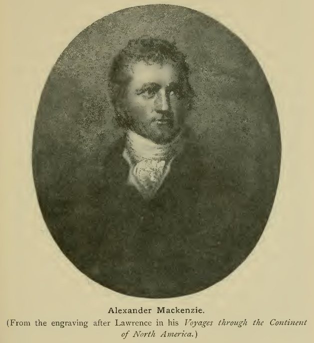
Alexander Mackenzie.
(From the engraving after Lawrence in his Voyages through the
Continent of North America.)
Pond—who, after leading the opposition for a time, seems to have soon gone over to the North-West Company—continued to be active in its behalf until 1788, when he retired, returning to New England in 1790. He was of a somewhat intractable disposition, and was implicated in more than one affray which resulted in the death of a fellow-trader. He was the author of several maps, in which his explorations were laid down, but, as he was not an expert in surveying, his representation of the geography is far from accurate as regards the positions assigned to the various features. Lake Athabasca, for example, is placed far too near the shores of the Pacific.
Alexander Mackenzie, who in 1785 had taken charge of the Churchill River district on behalf of his partners, soon began to look farther afield, and to make plans for an expedition to the shores of the Arctic Ocean. His cousin Roderick having, in 1788, founded Fort Chipewyan on Lake Athabasca for the purpose of trade with the Chipewyan Indians, he proceeded thither and set about the preparations for his proposed journey, which was to take him north by way of the Great Slave Lake, to which region traders had already begun to penetrate. One of the first to make his way thither after Hearne's discovery of the lake in 1772 was Laurent Leroux, who was now to accompany Mackenzie thus far on his journey and build a fort on the lake shore. The party, which included also a German named Steinbrück and several Canadian voyageurs and Indians, left Fort Chipewyan on June 3, 1789, and soon entered the Slave River at the western end of Athabasca. Passing the mouth of the strongly-flowing Peace River, they descended the broad stream, making portages past its dangerous rapids to the Great Slave Lake, beyond which all was virtually unknown ground. The weather was still very severe and the lake in great part still covered with ice, so that the crossing was only with difficulty effected, halts being several times necessary at islands on the route. Approaching the northern shore, and coasting to the westward, the voyagers proceeded up the North Arm of the Great Slave Lake, where they met a number of Red Knife or Copper Indians, with whom trade was opened. On June 25 Mackenzie once more started onwards, leaving Leroux to establish a post among the Copper Indians, while he returned down the western side of the north arm to the main body of the lake. After some days spent in coasting to the south-west, the wished-for outlet of the lake was at last reached. This river, to which Mackenzie's own name has fittingly been given, gradually narrowed, while its current increased in rapidity. The Horn Mountains, on the right bank, and the mouth of the Liard River, on the left, were passed in succession. Indians were seen, but most of them fled at the voyagers' approach, while others, by magnifying the dangers ahead, terrified Mackenzie's Indians, and much firmness was needed to prevent their deserting. On July 3, mountains were seen near the left bank, and Mackenzie ascended a hill which rose almost perpendicularly from the river, gaining an extensive view.
Warm weather now gave place to great cold, but the explorer pushed on with great determination, passing the mouth of the clear-flowing Great Bear River (coming from Great Bear Lake), and occasionally meeting Indians, who still preserved a shy and suspicious attitude. After passing the rapids since known as Sans Sault, which presented but trifling difficulties, the voyagers entered the narrow defile in which the river passes for some distance between perpendicular limestone cliffs, now known as the Ramparts. Beyond these, on entering the lowland which borders the Arctic coast of the continent, the river widened out and split into many different channels. From a new tribe of Indians now met with, intelligence of the Arctic Ocean was at last obtained. Supplies were by this time almost exhausted, but though his Indians became discontented at the continuance of the voyage, Mackenzie was determined to persevere. At last, on July 12, having passed the 69th parallel of north latitude, his little flotilla reached a point where the river widened out into a lake-like expanse, across which it proceeded to a high island, whence a wide view was obtained. This was evidently at the mouth of the river, and the object for which the leader had been striving had thus been attained, but he seems to have been hardly convinced that he had really reached the ocean. An observation taken on the 13th gave the latitude as 69° 14' N. Numbers of small whales were seen, and the island on which the party had landed was named Whale Island. On it a post was erected with a record of the visit, and, a search for Eskimos among the neighbouring islands having proved fruitless, on July 16 Mackenzie reluctantly began his return voyage. He had traced the great river which bears his name for a distance, by the windings of its course, of over 1000 miles from its exit from Great Slave Lake.
The re-ascent of the Mackenzie, above the apex of its delta, involved severe labour owing to the strength of the current. From the inhabitants of an Indian village Mackenzie heard some vague accounts of the sea to the west, and of visits to it by white men (probably the fur-traders on the coast of Alaska), as also of a great river which seems to have been the Yukon. A little above Bear River the right bank of the Mackenzie was noticed to be burning, as it has by more recent explorers, this being due to the seams of lignite which there crop out. On reaching Great Slave Lake, August 22, Leroux was met, returning with Indians from a hunting expedition, and at his house Mackenzie dismissed his Indians. He was once more back at Fort Chipewyan on September 12, having been absent on his expedition some three months and a half.
This journey, important as it was from a geographical point of view, seems to have attracted but little notice at the time, but Mackenzie's exploring ardour was not thus to be checked. For a time he was content to wait, quietly maturing his plans for a new venture, and in 1791-2 paid a visit to England for the purpose of procuring instruments, and otherwise qualifying himself for the task before him. This time his plan was to ascend the Peace River (the main feeder of the Mackenzie, which it joins shortly after the latter's exit from Lake Athabasca) towards the Rocky Mountains, and push west across these until the Western Ocean should be gained. Having made his final preparations at Fort Chipewyan, he left that post in October 1792, and proceeded by canoe across the western end of Lake Athabasca, and by its emissary to the Peace River. Pushing rapidly up this, as winter was now approaching, he passed the highest posts previously established on its course, and, after reaching the mouth of the Smoky River, decided to go into quarters for the winter. A fort was built at a point between 17° and 18° W., and here he and his men stopped until the spring was advanced enough to permit the continuance of the journey. During the stay Mackenzie was visited by Indians who told him of the lake (belonging to the basin of the Athabasca River) now known as the Lesser Slave Lake, and also of a river flowing west beyond the mountains. Having secured the services of two Indians as guides, Mackenzie set out in a newly-built canoe on May 9, 1793, accompanied, in addition to the Indians, by Alexander Mackay and six French Canadians. Continuing to ascend the Peace, through hitherto unexplored country abounding in game and displaying much beautiful scenery, the explorers found the river constantly broken by rapids during its passage through the Rocky Mountains, and only with great difficulty was the advance carried out, the canoe being often within an ace of destruction in the foaming waters. The men grew discontented, and urged a return, but Mackenzie would listen to no such proposal, but decided to cut a road through the bush on the mountain side so as to transport the canoe and goods to the smoother water above the gorge. This was accomplished by heroic efforts, and they at length reached the point of junction of the two upper branches of the Peace, since known as the Parsnip and the Finlay—the latter named after its first explorer some years later.

Western part of Mackenzie's Map, showing his routes.
(Outline sketch.)
Click on the map to enlarge it.
Somewhat against his own inclination, Mackenzie decided to follow the advice of the Indians and ascend the southern branch—the Parsnip. This river was in flood and its violent current could only be stemmed by immense exertion. Meeting at last with Indians who had never before seen a white man, Mackenzie obtained somewhat vague reports of the westward-flowing river of which he was in search. He soon afterwards reached the source of the Parsnip, and had thus in his two journeys followed the whole course of the Mackenzie, from the source of one of its principal head-streams to its mouth in the Arctic Ocean. Dragging the canoe across the continental divide, Mackenzie was the first white man to reach, by an overland route, a stream flowing west to the Pacific in the northern half of North America. It was a rapid mountain river, a tributary of the important stream afterwards known as the Fraser, from its explorer a few years later. Its descent nearly led to irretrievable disaster, the canoe being almost dashed to pieces on the rocks of a cataract. The men were ready to mutiny, but once more the leader, by sheer force of character, prevailed on them to go on, and at length, after incredible difficulties, the more easily navigable waters of the Fraser—thought by Mackenzie to be identical with the Columbia of Pacific navigators—were gained. The explorers' struggles were still not over, for rapids again necessitated a portage, and on meeting with Indians it was only by the exercise of the utmost patience and tact that they could be induced to lay aside their suspicions and open a friendly intercourse.
The accounts now received of the difficult navigation of the Fraser, and the report of an easier route west across the mountains, decided Mackenzie to abandon the attempt to trace the river seawards. To find the Indian trail it was necessary to re-ascend it some distance, and to build a new canoe. Meanwhile the Indians again proved suspicious, and it was with great difficulty that a guide could be induced to accompany the party. The march was begun on July 4, the men being heavily laden, while short rations and the inclemency of the weather added to their troubles. They were cheered, however, by reports of the sea and of white men frequenting the coast. The travellers ascended the valley of the Blackwater, a right-bank tributary of the Fraser, and after crossing a secondary divide, came upon a friendly tribe of coast Indians, dwelling on the banks of the Bella Coola River. From them canoes were obtained, and the descent of the Bella Coola was continued until, on July 20, its mouth was reached, and the western coast—the object of so many ardent aspirations—was thus at last gained. The point at which it was struck had been visited a little time before by Vancouver, and the surveys of explorers from east and west were thus for the first time linked together.
The Indians here proved unfriendly, so, after fixing his position as about 52° 21' north latitude, and painting on a rock the simple but pregnant inscription, "Alexander Mackenzie, from Canada, by land, the twenty-second of July, one thousand seven hundred and ninety-three," the traveller at once began his homeward journey. The Indians on the Bella Coola caused some trouble, but were overawed by Mackenzie's resolute attitude, and the march was continued with all speed, the supplies being by this time nearly exhausted. By August 14 the party had already reached the Fraser, and by the 17th, the Parsnip. The descent of the latter and of the Peace was effected at a very different rate of progress from that maintained during their toilsome ascent, and on August 24 the fort on the Peace River was gained and the toils and dangers of the expedition were at an end. The return from the Pacific had occupied little more than a month.
This second expedition of Mackenzie was one of the most important ever carried out in this part of North America, and its ultimate results were of a far-reaching character. The determination with which he overcame the most serious obstacles places him in the front rank of pioneer explorers. After he had thus shown the way to the Western Ocean, others soon followed in his footsteps, and it was not long before the general features of the Rocky Mountain zone and Pacific slope in the modern province of British Columbia were disclosed to the world. But the story of the future exploration of this region—associated above all with the names of David Thompson, Alexander Henry the younger, and Simon Fraser—belongs almost entirely to the next century and thus lies outside the limits of our period.
A new period of exploration in the far west was ushered in by Mackenzie's epoch-making journey, but a good deal remained to be done before even the pioneer work in the region east of the mountains could be said to be finished. At the period at which we have now arrived some tardy steps were taken by the Hudson Bay Company to do its share in the exploration of the western interior. At the instance of the Colonial Office in London, the Company commissioned a surveyor, Philip Turner by name, who had been for some time in its service, to explore the country between Cumberland House and the Great Slave Lake. He travelled over this country in 1790-92, and the resulting map gave for the first time an approximately correct representation of Lake Athabasca, with the river system of the southern part of the Mackenzie basin, while other details were filled in from information collected. He was succeeded by Peter Fidler, who seems to have assisted him in a part of his work, and who executed important surveys for the Company, though the full details of his explorations—which appear to have begun in 1792—are not now known. From the map which he constructed, and a few other indications, it appears that his journeys covered a very wide area, both in the basin of the Saskatchewan and, further north, in those of the Mackenzie, Churchill, and other rivers emptying themselves into Hudson Bay. In the west they extended to the Lesser Slave Lake and the lower course of the Peace River, and in the east they resulted in the first map of the lower Churchill, and in an improved representation of various other rivers and lakes between Athabasca and the shores of Hudson Bay. Fidler continued his labours till well into the next century, and though a good deal of the ground covered was not entirely new, his surveys were a valuable contribution to the knowledge of the geography of this region.
During the same period, equally extensive journeys, in part over the same field, were made by David Thompson, one of the most active and determined explorers produced either by the Hudson Bay Company or its great rival. Few, in fact, of the world's explorers by land have covered such a great extent of unknown or imperfectly-known country, or continued their activity through so long a period as did David Thompson. The first part of his career was spent in the service of the Hudson Bay Company, and though much of his time was necessarily given up to trading and the founding of stations, he showed throughout the greatest zeal in laying down his routes, and in fixing his positions by astronomical observations. In 1797, after his wanderings had taken him over the length and breadth of the region between Hudson Bay and the Rocky Mountains, he left the Hudson Bay Company's service, in which his passion for exploration no longer found sufficient scope, and joined the North-West Company, which was more ready to encourage such enterprise as Thompson had at heart. In its service a wide field for exploration opened before him in the almost unknown wildernesses stretching from the Rocky Mountains to the Pacific, but, as has been said above, this part of the history falls within the nineteenth century and cannot be dealt with here.
By the close of the eighteenth century the broad outlines of the geography of the vast region between Hudson Bay, the Great Lakes, the Arctic Ocean, and the Rocky Mountains had thus been sketched in, while the pioneer journey of Mackenzie to the Pacific had already paved the way for the opening up of the region still farther west. Political events had brought it about that the work during the latter part of the century had fallen entirely to British subjects, while British traders and surveyors, working independently from the side of the Pacific, had likewise secured an undisputed position on its more northern coasts, and thus helped to lay the foundation of a British Dominion from shore to shore of the continent.
II. The Mississippi Basin.
While the latter part of the eighteenth century was thus a period of rapid advance into the far north-west of Canada, nothing at all comparable to these achievements took place in the more southern region of the continent, now occupied by the United States. As in the earlier period, when the French were rapidly pushing outwards in Canada and on the Mississippi, the English settlers on the Atlantic seaboard were long content with a more gradual and steady expansion. The nearly continuous range of the Alleghanies formed a natural barrier to the growth of the Eastern colonies, and long marked the extreme limit of knowledge from the east, though, as we have seen in an earlier chapter, the French, as represented by La Salle and his coadjutors, had by their descent of the Mississippi drawn a band of known ground round the hinterland of the British colonies. No such unlimited field was therefore open here to touch the imagination and fire the ardour of explorers as in the Canadian West, though an important and arduous task awaited them in the opening up of the rough wilderness between the Alleghanies and the Mississippi. A few figures stand out amid the host of nameless pioneers as having contributed to a knowledge of this region. About the middle of the eighteenth century many journeys to the region of the Ohio were made by agents employed to negotiate with the Indians both before and during the French wars.[1] Conrad Wieser, a Würtemberger who had settled in Pennsylvania and became a noted interpreter, was sent to negotiate with the Indians in 1748. George Croghan, an Irish settler in Pennsylvania, also noted as an Indian agent, made a number of journeys to the Ohio between 1747 and 1765, in which last year he carried out a rough survey of the river during a tour down it towards Illinois. In 1758-59 a Moravian missionary, Christian Frederick Post, undertook embassies to the Indians on the Ohio, whose neutrality he secured at a critical juncture. He afterwards founded a mission within the limits of the modern State of Ohio. Kentucky also began to be systematically explored only about this time, though it had been reached by individual adventurers much earlier.[2] The first to do much with a special view to exploration was Dr Thomas Walker of Virginia, who in 1748 discovered the pass near the southern end of the Alleghany system, destined to play so important a part in the future history of the region, and ever since known by Walker's name of Cumberland Gap. The Cumberland Mountains and River were also named by Walker, who two years later made a more extended exploration, with five companions, to the headwaters of the Kentucky. Between 1751 and 1767 adventurers spread themselves in increasing numbers over these great hunting grounds, names deserving mention being those of Christopher Gist, Wallen, James Smith, Harrod, and Finly. But among the host of "backwoodsmen", who made their order famous for determination and hardihood, few stood out as markedly more meritorious than their fellows, and for a time little practical result ensued.
[1 The French on the Great Lakes had long known the general course of the Ohio, at least in its upper portions, the river being used as a line of approach to the region beyond. But neither they nor the early English pioneers had gone far into the wildernesses on the south side.]
[2 Among these were Colonel Wood, who penetrated into the country soon after the middle of the 17th century; and, some years later, traders named Doherty and Adair.]
It was to a farmer of North Carolina, Daniel Boon by name, that the first real impetus towards the opening up of the great central basin of the modern United States was due. A typical backwoodsman, passionately devoted to the wandering life of the hunter and explorer, Boon exhibited the daring, fortitude, and self-reliance of his class in a peculiar degree, coupled with other qualities which inspired confidence and enabled him to play a leading part among his associates. Leaving his home, with five others, on May 1, 1769, and crossing the mountains by difficult paths. Boon descended westward into the fertile and forest-clad plain of Kentucky. During his wanderings here he had the misfortune to be captured by Indians, but, effecting his escape, joined his brother, who had followed him across the mountains. In 1773, he decided to move with his family into this new and promising region, and the first step towards the settlement of Kentucky was thus taken. Various survey parties soon visited the country. One of the most active leaders was John Floyd, who in 1774 led a party down the Kanawha and Ohio to the Kentucky River and beyond, traversing the country in various directions as far as the Falls of the Ohio. Floyd made his way back amid considerable hardships by way of the Cumberland Gap. About the same time settlements began to be made in the upper basin of the Tennessee River, between the Cumberland Mountains on the north-west and the Great Smoky Mountains on the south-east; the most active pioneers in this direction being two young men named John Sevier and James Robertson.
The war between the colonists and Indians which took place in 1774, and is known as Lord Dunmore's War from the English Governor of Virginia who carried it through, led to a temporary withdrawal from Kentucky, though by weakening the power of the Indians it helped in no small degree to make possible the further opening up of this central region. In 1775 settlement on a more extended scale was inaugurated by an enterprising pioneer named Nathaniel Henderson, who had raised himself by his personal qualities from a low station. Securing the cooperation of Boon and others, he obtained a concession from the Indians and for a time formed a semi-independent republic in the wilderness. During the troublous time of the revolution, from 1775 onwards, operations were extended into the country north of the Ohio, then occupied by scattered French settlements under British suzerainty. The daring scheme of the conquest, for the revolted colonies, of this important tract (lying between the Great Lakes, the Ohio, and the Mississippi) was due to the enterprising Kentucky pioneer George Rogers Clark, who in 1778 descended the Ohio almost to its mouth with a small force of frontiersmen, and made a bold march north into the heart of this region, taking Vincennes on the Wabash by surprise, and even holding his own against the English Governor Hamilton who marched against him from Detroit. In this way an immense tract of territory, first opened up from the side of Canada, passed eventually into the possession of the United States. By the end of the century most of the country east of the Mississippi had thus been brought within the ken of civilisation. The lands beyond the Mississippi had, for the most part, to wait their turn till the new century had begun.
{Page 350}
I. North America.
Besides the maritime efforts spoken of in a previous chapter, a certain amount of land exploration was effected during the eighteenth century on the western side of North America from the base afforded by the Spanish settlements in Northern Mexico. It will be remembered that, quite in the early days of the Conquest, Spanish adventurers like Coronado had pushed north into the basin of the Colorado, but their achievements had to a large extent fallen into oblivion, and the later explorers had virtually to begin afresh in this direction. As in other parts of the Spanish dominions at this epoch, most of the advance was due to the zeal of the missionaries, particularly the Jesuits, who extended the bounds of knowledge either by journeys with the special object of exploration, or incidentally to the prosecution of their more special work. Some attempts were also made on the part of the Spanish Government, but the want of energy and settled plan with which they were prosecuted rendered them in great part fruitless. It had long been a desired object with the Mexican authorities to discover a harbour or harbours on the coast of California at which the ships from the Philippines might refresh on first striking the coast of North America, and it was with this purpose that the voyages of Vizcaino in 1596 and 1602 had been undertaken. Somewhat later, a special object of investigation was the ascertainment of the true character of the peninsula of Lower California, for though in the early maps based on Spanish voyages during the sixteenth century (among others, that of Sebastian Cabot in 1544) it had been correctly shown as a peninsula, an error was subsequently introduced and persisted throughout the next century, by which California was held to be an island.[1]
[1 This was due to a false report that ships had sailed out into the ocean from the northern end of the Gulf of California.]
Among the Government expeditions during the latter part of the seventeenth century the most important was that of Don Isidro Otondo, in 1683-85, in which three Jesuits, Fathers Kühn (Kino in Spanish), Copart, and Goni took part. In the person of the first-named an actor appeared on the scene who was to play an important part in the opening up of this region. Attempts were made to found settlements on the eastern side of the peninsula, and parties were also sent into the interior. But the barrenness and rugged nature of the country stood in the way of success, and, difficulties with the natives also arising, Otondo eventually found it necessary to reembark the whole of the intending settlers and sail back to Mexico. The work of nearly three years was thus without any direct result. But the expedition was not without its influence on future events. Kühn's interest in California was not allowed to slumber. Having obtained an appointment in the Sonora Missions on the opposite mainland, he succeeded in communicating his own enthusiasm to another Jesuit, Father Juan Salvatierra, during a visit of inspection by the latter. After many rebuffs Salvatierra was authorised to establish a mission in the peninsula, and he set out for that purpose in October, 1697. In spite of many difficulties, both from the nature of the country and the fickleness of the natives, he succeeded in establishing the mission on a more or less solid foundation, aided by Father Piccolo and others. From the mission of Loreto, on the inner side of the peninsula, expeditions were made into the interior, and on one of these a sight of the Pacific was obtained. Meanwhile Father Kühn had not been idle. With untiring energy he traversed the length and breadth of Sonora, opening up new missions towards the north, and using every opportunity of extending geographical knowledge. On some of his journeys he was accompanied by an officer, Juan Mateo Mange, whose diaries supply a detailed account of their experiences. In 1694 Kühn went north as far as the Gila (the last important tributary of the Colorado), and in 1697 accompanied a military expedition to that river. He again made his way to the Gila in 1698, and thence reached the coast of the gulf, where he found a good port with fresh water and wood. Determined if possible to settle the question of the junction of California with the mainland, he set out again in September, 1700, accompanied by Indians of various tribes. Reaching the Gila once more, he descended it to its junction with the Colorado, in the country of the Yuma Indians. Failing to reach the sea, he turned back and, climbing a high mountain, obtained a distant view of the mountains of California and the mouth of the Colorado.
Kühn was now convinced of the peninsular character of California, though he had not actually proved its connection with the mainland. Before the end of 1700 Salvatierra paid a visit to Sonora and in March, 1701, Kühn and he undertook a new journey in concert. They at first tried to cross the wide expanse of sands near the head of the gulf, but without success, though Kühn climbed a hill and gained a view of the opposite coast and the Californian mountains. Trying again by a more inland route they obtained another distant view, but were then forced to retrace their steps. In November of the same year Kühn went north again, and, after crossing and recrossing the Gila, followed the Colorado through the country of the Yumas and Quinquimas, and crossed to its western bank on a "balsa" constructed of trees. He found great numbers of Indians inhabiting a level and partially wooded country, with a good soil, and learned that the South Sea could be reached in ten days. But having no means of taking his animals across the Colorado, there a stream 200 yards in width, he had once more to retrace his steps. Finally in February, 1702, he made a last attempt, accompanied by Father Gonzales. This time he followed the Colorado to its mouth, but the serious illness of his companion once more necessitated a return, the latter succumbing to the fatigues of the journey on reaching the first mission station.
By these journeys Kühn virtually solved the problem which had so long exercised the minds of his contemporaries, though it was left to another of the missionaries to finally set at rest all doubts on the subject.
Other workers had now joined Father Salvatierra in the peninsula, the most active among them being Father Ugarte, who from his station on the mainland had already done much to help by collecting and forwarding supplies to the advanced posts in California. In 1703, among other journeys, Salvatierra made one across the peninsula to its outer coast. Three years later Ugarte, accompanied by Father Bravo, carried out a further examination of that coast, but found it barren and unpromising. His party was reduced to serious straits for want of water and only made its way back to the gulf after suffering severe hardships. In 1719 Father Guillen likewise made an attempt in the same direction, but though he reached the Magdalena Bay of Vizcaino, near the southern end of the outer coast, he too found the scarcity of water an insuperable obstacle. A more successful expedition on the gulf side of the peninsula was carried out in 1721 by Ugarte, who sailed from the port of Loreto in May of that year to survey the coasts to the north. Besides a larger vessel, he had at his disposal a pinnace and boat, which permitted the survey of the shallower waters adjoining the coast. After following the west coast of the gulf for some days, the expedition crossed over to the mainland side and opened communication with the mission of Caborca, one of those founded by Kühn. Ugarte now became seriously ill, but resolutely stuck to his task. Crossing to the west side of the gulf in three days, the party experienced much difficulty on account of the violent tidal currents. The sea also changed its colour, becoming generally reddish from the effect of the Colorado water. The vessels anchored at last near the eastern mouth of the river, which was in flood and carried down large quantities of grass, leaves, tree-trunks, etc. The junction of the peninsula with the mainland was ascertained by a distant view, and the height of the tides was also regarded as indicating that the gulf was completely closed in to the north. On July 16 Ugarte turned south, but the troubles of the expedition were not yet over. Scurvy made its appearance, and with their reduced strength the voyagers had to combat a succession of storms, which so impeded their progress that it was not till September that they were once more back at their starting point.

The Jesuit Map of Southern California.
(From Venegas's History of California.)
Click on the map to enlarge it.
The general contours of the gulf were now ascertained with more or less accuracy, and much credit is due to Ugarte for the determined way in which he carried out his task in the face of many obstacles. His work was somewhat improved upon a quarter of a century later by Father Consag, who, in view of the contemplated completion of the conquest of California, was commissioned to make a survey of the coasts of the gulf as far as the Colorado River. This he did in 1746, making besides a fruitless effort to ascend the Colorado; the result being, however, to confirm the general correctness of Ugarte's statements. Consag afterwards (1751-53) made journeys on the outer coast of the peninsula, towards the north, while in 1756 Father Wenzel (Wenceslaus) Link partially explored the northern peninsula by land.
Further attempts had been made a little before this to extend the Spanish influence northwards from the side of the mainland, though little had been added to the knowledge previously acquired. One of the objects in view was the establishment of missions among the Moqui Indians, to the north-east of Sonora, in a region towards which some advance had already been made by the Franciscans. In 1743 Father Keler set out on a journey to the north, but he had but an insufficient escort, and was forced to turn back after proceeding some days' journey beyond the Gila. In 1744 Father Sedelmayer made an attempt in the same direction, but though he visited the Yuma Indians, he shed no new light on the geography of the region. A more important journey was made some years later by Father Garcés, a Franciscan who had been in charge of the mission of San Xavier del Bac in Sonora;[1] for, since the expulsion of the Jesuits from all the Spanish dominions in 1767, their place in these missions had been taken by the Franciscans.
[1 The province of Sonora then extended beyond the limits of the modern Mexico, and San Xavier was in what is now Arizona, a little south of Tucson.]
From 1768 onwards Garcés made various expeditions for missionary purposes, partly to discover new routes between the widely-scattered stations in Sonora and California. The first two, in 1768 and 1770, were of no great importance. In 1771 he descended the Rio Gila to the Colorado, and crossed the latter to its western bank in the country of the Yumas. His wanderings are not easy to trace, but he seems to have almost reached the mouth of the Colorado before returning to the Gila, and so south to Caborca. About this time more serious efforts were being made by the Spanish authorities to extend their settlements along the coast of Upper California, as has already been mentioned in the chapter dealing with Pacific voyages; and it was felt to be particularly desirable to open up an overland route to the port of Monterey on that coast (occupied in 1770), while the extension of the missions in this direction was also taken in hand. In 1774 Captain Juan Bautista de Anza was commissioned to find a way overland from Mexico to Upper California, and Garcés accompanied him as chaplain. The party made its way, by the Gila and Colorado, to the mission of San Gabriel, which had been established near the coast of Upper California in about 34° N., not far from the modern town of Los Angeles. The main body returned by the same route, while Garcés turned aside to visit one of the Yuma tribes on the Colorado. In 1775 Anza was sent on a more important errand—for the establishment of a mission and government station at San Francisco—and Garcés again started with him. On arriving at the Yuma country, however, he once more went exploring on his own account. From the Colorado mouth he ascended the river to Mojave in lat. 35° N., proceeding thence west by a new route across country to San Gabriel. Once more setting out from this station, he made a trip north to the Tulare valley, afterwards returning to Mojave, and continuing his journey eastward to the Moqui country, which, it will be remembered, had been an objective of several of the Jesuit missionaries in the closing years of their regime. This was his farthest towards the north-east, and he now retraced his steps by Mojave to the Yuma country and returned by the Gila to his station of Bac, which was reached on September 17, 1776.
This journey of Garcés had broken a certain amount of new ground, and it was quite the most important of his entradas, as these pioneer journeys of the missionaries were styled at the time. Three years later it was decided to found a mission among the Yumas, several coadjutors being assigned to Garcés for the purpose. The attempt led to disaster, the measures adopted being injudicious. Some of the best lands of the Yumas were appropriated by the settlers, and the discontent naturally fostered by this proceeding led to a wholesale massacre of the Spaniards, Garcés and his fellow-workers falling victims among the rest.
A still more important journey was made at this time by two other Franciscan friars, Fathers Escalante and Dominguez, still with the object of opening up an overland route from Northern Mexico to the Pacific seaboard. The starting point was the city of Santa Fe, long before established on the northern frontier of the Spanish dominions, and as this lay far to the east of Sonora, a correspondingly longer journey was involved than in the case of attempts from the western province. The friars did not actually accomplish their purpose, but they traversed a large extent of new country, and their journey constituted the most important exploration achieved before the beginning of the nineteenth century in the south-west of the modern United States. Setting out from Santa Fe in July, 1776, with two officers and five soldiers, they took a north-westerly course, crossing the Upper Rio Grande and entering the basin of the Colorado. On reaching the head-waters of the San Juan, its eastern tributary, the party seems for a time to have turned to the west, but again took a more northerly course across the plateau region between the San Juan and the Upper Colorado, following for a time the course of the Rio Dolores. After visiting an encampment of Yuta (Utah) Indians the travellers crossed the Grand River or Colorado early in September, and continuing on a north-west course soon afterwards came to the Green River, the second main head-stream of the Colorado, before reaching which a buffalo was killed. On crossing the Green River they were in the country raided by the dreaded Comanche Indians, but they do not seem to have encountered any of these. A difficult route across the mountains brought them to a stream flowing south-west into a lake, known to the natives as Timpanogos, but which has since received the name Utah—the small lake which discharges north into the Great Salt Lake, the hydrographical centre of the vast tract of inland drainage now known as the Great Basin. The natives hereabout (Yutas or Utahs) lived in primitive fashion, and the fathers found no towns like those of the Moquis and Zuñis as they had hoped. At first timid, these people soon became friendly and expressed their willingness that a mission should be established among them. They also gave a good deal of information on the geography of the surrounding region, telling in particular of a larger lake to the north (the Great Salt Lake of later days), whose saline waters were very injurious to those who bathed in them.
The fathers had now pushed considerably north of the direct route to Monterey, whether from a desire to find out as much as possible about this northern terra incognita, or because the difficulty of crossing the region of canons about the middle course of the Colorado had necessitated their making a circuit. It was therefore necessary, in view of the advancing season, to turn their steps southwards, a direction which led them by the valley of the Sevier River (which they called Santa Isabel) and past the lake of the same name. When in the valley now known as Escalante they enquired in vain for the sea or the Spanish settlements, and after a difference of opinion had been settled by casting lots, they turned eastward for the Colorado, which was reached on October 26. Some days were occupied in the search for a ford, which was at last found in 37° N. The first settlements of the Moquis were reached on November 16, but though these people expressed a readiness to live in friendship with the Spaniards, they declined to allow the establishment of a mission. Zuni was passed towards the end of the month and on January 2, 1777, the party was once more back in Santa Fé. The fathers had achieved an important piece of exploration, and Escalante's narrative of the journey contains a good deal of information on the features of the country, its climate, products, and people.
This journey marks the farthest advance of the Spaniards in the interior of North America. It was not followed up, and it was half a century later that fur hunters and other adventurers from the United States first made their way to the region of the Great Salt Lake.
II. South America.
Like the century which preceded it, the eighteenth century was in South America a period of strong missionary activity, the Jesuits and other orders continuing to push their posts farther and farther afield, until, at the time of their greatest extension, there were few parts of the continent in which their influence was not to some extent felt. The quest of mineral wealth and slaves was accountable, too, for a good deal of exploring activity, especially in the Portuguese possessions. Some of the first purely scientific work in South America was also done during the century, but this was but a beginning, though an important one, and it can hardly be said to affect the general character of the century's output.
To begin with the part of the interior longest open to European influence—that of the upper basin of the La Plata—we have seen in a previous chapter how various attempts were made in the seventeenth century to establish missions among the tribes known by the general names of Chiriguanas and Chiquitos, towards the frontiers of Bolivia, and how the Spanish missions to the latter had begun, at the close of the century, to feel the encroachments of Portuguese adventurers from the side of Brazil. The Chiriguanas proved so intractable that the attempt to convert them was soon abandoned, efforts being concentrated on the more amenable Chiquitos. The desire to open up a shorter and easier route from the more eastern missions to the Chiquitos country led to various journeys which did something to improve the knowledge of the upper basin of the Paraguay. In 1702 Fathers Francisco Hervas and Miguel de Yegros went east from the Chiquitos mission of San Rafael, reaching a river which they thought to be the Paraguay or a branch of it, and setting up a cross as a landmark. In 1703 Hervas, with Father de Arce and several others, was sent up the Paraguay in order to reach the same spot. In spite of the treacherous behaviour of the Payaguas dwelling on the river's banks, they pushed on, but searched in vain for the mark set up the year before. It became necessary to turn back, and the return journey was only accomplished with much hardship. In 1704-5 Yegros made a new attempt from the Chiquitos country, and ascertained that the river reached in 1702 had no connection with the Paraguay. In 1715 Fathers de Arce and Blende tried once more from the side of the Paraguay, but failed to effect the desired junction, and on their return were both murdered by the natives, in revenge for wrongs done by Spanish adventurers. The attempt by the Paraguay was now given up, and attention turned to the Pilcomayo, its most important western tributary. In 1721 it was arranged that parties should start from both sides simultaneously, Fathers Patiño and Rodriguez ascending the river, while a party from Tucuman endeavoured to meet them. The latter advanced no great distance before turning back, but Patiño and his companion did a notable piece of work, which no traveller improved upon for many years. The labyrinth of channels and the extensive swamps which characterise the middle course of the Pilcomayo make both its navigation and travel along its banks a matter of great difficulty—so much so that a portion remained imperfectly known at the beginning of the twentieth century. Having ascended the river for 60 leagues in a vessel of some size, the fathers went on in boats a distance which they estimated at 1000 miles, and their turning point was said to have been only some 60 miles below Santa Barbara. A treacherous attack by the Toba Indians necessitated a retreat, the return being accomplished in safety, though the main object of the journey remained unfulfilled. Twenty years later, in 1741, a renewed attempt to ascend the Pilcomayo was made by Father Castañares, but he too was forced to turn back. The next year he went to Bolivia, and, starting from Tarija, began the descent of the Pilcomayo, hoping to find the difficulties less in this direction. But on reaching the neighbourhood of Santa Barbara he was attacked and murdered by Indians—the Mataguayos—and this, like all previous attempts to open the Pilcomayo route, thus ended in failure. The explorations of the Jesuits in this region were finally brought to a close by the expulsion of the order from all the Spanish dominions by the decree of 1767. The extent of the Jesuit knowledge of this part of South America is well shown by the maps of Matthew Seutter, D'Anville and others. D'Anville's version, prepared for the Lettres Édifiantes et Curieuses, is here reproduced in outline.

The Jesuit Map of Paraguay as shown by D'Anville.
(Outline sketch.)
The missions to the tribes known to the Spaniards by the general designation Moxos were gradually extended farther afield during this century, but with no great results from a geographical standpoint. A greater extension of knowledge was due to the Portuguese adventurers in Mato Grosso, that vast and thinly peopled wilderness, most difficult of access of all the Brazilian provinces. In 1734 mines were discovered in this region by Antonio Fernandez de Abreu, and adventurers soon began to flock in in the hope of making a speedy fortune. Among these was Manoel Felix de Lima, one of the original companions of Abreu, who, failing to make profit out of the mines, turned his energies to an exploring venture still farther afield, in the direction of the great Madeira tributary of the Amazon. Although the Moxo missions had been long established on the head-waters of the Madeira system, the middle course of the great river was still but little known, though some attempts to push upwards from its lower basin had been made from the side of Pará. Thus some twenty years before the date of Manoel Felix's venture, an expedition under Francisco de Mello, acting under the orders of the governor of Pará, had ascended as far as the Mamore. The Spanish authorities had put obstacles in his way and he had been forced to return, no practical result being gained by his journey.
Manoel Felix was a native of Portugal, and, though superstitious, of a somewhat higher class than many of the adventurers of the time; but his companions were in great part men of broken fortunes, who joined him with a view to escaping their creditors. A start was made in 1742. After following down the Sarare to the Guapore, and beginning the descent of the latter, the party divided, some of the adventurers being dismayed at the difficulties in store. Manoel and the rest continued the voyage, and with some difficulty found their way to a mission on the Baures, in charge of a German Jesuit who had adopted the half-Spanish name of Gaspar de Prado. This was the most recent establishment of the Moxo missions, and the Mura Indians among whom the father was working were under very partial control. Both here and at a settlement on the Ubay (under Joseph Reiter, a Hungarian) the voyagers were well received until orders came from the Provincial of the missions that they were to be dismissed. Re-entering the Guapore, they soon reached its junction with the Mamore, and continuing the voyage, passed the mouth of the Beni, the third great head-stream of the Madeira. They now encountered dangerous falls and rapids, while their troubles were increased by the shortness of their food-supply and the constant plague of flies. The canoe struck on a rock and was lost, but another was providentially discovered caught between two rocks near an island. The last fall having been passed, traces were seen of an abandoned settlement of the Portuguese from Pará. Hunger began to press severely on the party, but they at last obtained relief at a Portuguese mission station, and, passing two others, eventually entered the main stream of the Amazon, having traced down its largest tributary from almost the very head of one of its main branches.
On reaching Pará Manoel was sent to Lisbon to report on his journey, which the authorities regarded as of considerable importance. He had himself formed an inordinate idea of the value of his services and made correspondingly excessive claims. He frequented the court for some years in the vain hope of getting them recognised, and died in extreme poverty. Some of his comrades, after returning to Mato Grosso, made a second expedition under Francisco Leme, but it was without important result.
Somewhat further east, one João de Sousa e Azevedo made an adventurous journey about this time in the borderlands between the Paraguay and Amazon basins, through country that has remained but imperfectly known down to our own times. From Cuyaba in south-east Mato Grosso he descended the Cuyaba River to the Paraguay, ascended the latter river and one of its tributaries to the water-parting, and made his way across this to the basin of the Tapajos, one of the great southern tributaries of the Amazon.
The Portuguese and Spaniards had now come in contact in the very centre of the continent, and efforts were made on both sides to secure control of the debateable ground forming the frontier zone. In 1749 an expedition was organised from Pará for the purpose of repeating Manoel Felix's journey in the reverse direction by ascending the Madeira to Mato Grosso; and it was placed under the leadership of Francisco Leme and his brother. Though the object in view was eventually attained, the expedition underwent many dangers and hardships on the way. About three weeks up the Madeira it was attacked by a band of Muras, but they were repulsed. Light canoes were built for the passage of the rapids, but these were surmounted only with great labour, frequent portages being necessary. On reaching the first Spanish mission near the mouth of the Mamore, the travellers were agreeably surprised at receiving a friendly welcome, the accession of Ferdinand VI to the throne of Spain having, through the influence of his Portuguese queen, greatly improved the relations between the two kingdoms. But their troubles were not yet over. It was now the most unfavourable season of the year for travel: all the rivers were rising, and the retreat of animal life from the banks made it almost impossible to procure food-supplies from the woods. Some help was obtained from Father Gaspar at San Miguel, but difficulties in the shape of flooded lands, disease, and want of food, still pursued the party. It became necessary to send on the most fit in canoes, to bring supplies from the nearest Portuguese settlements, and with this aid they at last reached the Sarare, and three days later the post of Pescaria, having spent nine months on the journey. The water-route thus opened up now became fairly frequented.
Further south, exploration was carried on little by little in the western parts of the La Plata basin, and on the coasts of Northern Patagonia, though the wild region known as the Gran Chaco long remained almost untraversed by white men, except on its outer borders. Political events had much to do with the increase of activity displayed during the second half of the eighteenth century. It had become eminently desirable that the possessions of Spain and Portugal should be more clearly delimited in the centre of the continent than had hitherto been the case, and the improved relations now prevailing between the two crowns soon had their outcome in a treaty, concluded in 1750, by which the entire mutual frontier in South America was defined in detail, so far as geographical knowledge permitted. The information recently gained made it possible to draw the line of partition with some regard to geographical facts, though in certain parts, especially along the extreme north-west borders of Brazil, it was perforce left extremely vague pending further examination of the country. This treaty is noteworthy for its recognition of accomplished facts and the setting aside of old claims based on the Pope's division of the newly-discovered lands between Spain and Portugal at the time of the discovery of America. But it was not destined to come into force, for the threatened transfer to Portugal of some of the Spanish missions among the Guaranis, and eviction of these from their homes, led to a revolt of that people, and before this had been finally quelled, both parties to the treaty had become dissatisfied with its terms. By mutual consent it was allowed to lapse, to be replaced nearly thirty years later (1777) by a new treaty, which has ever since formed the basis of the political partition of South America, though its ambiguities gave rise to many disputes in after times.
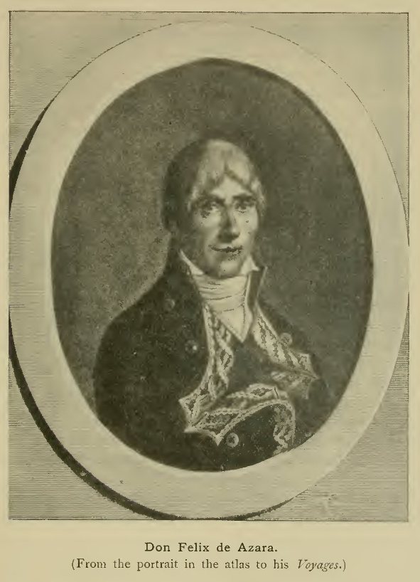
Don Felix de Azara.
(From the portrait in the atlas to his
Voyages.)
This treaty was the means of bringing on the scene one of the greatest travellers in South America during the eighteenth century, whose activities in the southern half of the continent were, however, soon to be matched and even surpassed by those of Humboldt in the northern half. This was Don Felix de Azara, a Spanish officer born in 1746, who, after receiving a severe wound in the campaign against the Algerian pirates in 1775, was in 1780 appointed one of the Spanish commissioners for the delimitation of the boundary between Brazil and the Spanish provinces in the basin of the La Plata. Azara, who received the naval rank of captain in connection with this appointment, was one of several commissioners who set sail for South America in 1781. The boundary to be laid down extended from the sea in the south-east, to the Madeira below the junction of the Mamore and Guapore in the north-west. It was divided into five sections, the second pair of which, starting from the sea, were assigned to Azara as his share of the work on hand.[1] Proceeding at once to Asuncion, the capital of Paraguay, he began operations, but soon found that the Portuguese commissioners, dissatisfied with the course assigned by the treaty to the boundary, were in no haste to complete their task, The delays thus occasioned were utilised by Azara in extensive journeys on his own account through various parts of Paraguay (which then extended much beyond the limits of the modern state of that name), it being his ambition to map the province for the first time in accordance with the new standards of his day. From his description of the methods he employed it is evident with what care and efficiency his work was performed, and the result was the acquisition of a knowledge of the Paraguay region far in advance of anything previously available, though Azara was obliged to supplement his own work with the most trustworthy of previous data. Not content with a mere topographical survey, he devoted himself with untiring energy to the investigation of the natural history of the region—a task which he took up under serious disadvantages as he had had no previous training in these branches of study. But this want was in part at least made up for by the extreme care with which his descriptions were written down, so that his works on the natural history of Paraguay were long drawn upon as standard authorities.
[1 The two nearest the sea were assigned to Azara's colleague Varela.]
After 13 years' work in the northern interior, Azara received a new commission, being placed in charge of the whole southern border, where the authorities were desirous of extending Spanish influence in the regions of the Pampas Indians. The desert nature of much of the country, and the risks of attack by the wild inhabitants, rendered the task a difficult one, but here too a greatly improved knowledge resulted from Azara's labours. After completing this mission, he turned his attention to the region of the lower Paraná (which was surveyed in conjunction with two assistants, Cerviño and Ynciarte) and the district of Santa Fé. After this he was sent to the eastern frontier, which he surveyed and mapped, and his last service was the settlement of colonists in this part of the country near the sources of the Ybicui. These various labours occupied him till the beginning of the new century, and it was only in 1801, after twenty years' arduous work, that he received permission to return to Spain. He had suffered much from the jealousy of the authorities in South America—one viceroy even making the attempt to palm off Azara's natural history memoirs as his own—and everything had been done to prejudice him with the home government. That he persevered with his (in part at least) self-imposed tasks in spite of these drawbacks is one of his most cogent claims to our admiration.[1]
[1 Owing to the obstacles put in his way by his superiors, only a part of the voluminous results of Azara's researches was published during his life-time, and at least one important memoir did not see the light till our own times.]
We must now go back somewhat in time, and consider the advance effected during the eighteenth century in the northern half of South America, where also some progress was made, though hardly so much as further south, until a new era was opened by the masterly labours of Humboldt begun in the last years of the century. As mentioned in a previous chapter, the expeditions of Teixeira and his colleagues on the main stream of the Amazon were followed by inroads of Portuguese adventurers into the regions watered by its various tributaries. Their main object was the quest of slaves, which they procured by the detestable practice of stirring up wars among the native tribes, and then "ransoming" the captives taken by one side or the other. In this way, during the first half of this century, they had begun to frequent the region of the upper Rio Negro, and so to approach the Spanish settlements pushed south from Venezuela by way of the Orinoco. As usual, the most advanced posts were those established by the missionaries, who had already settled in the region of the falls on the middle course of the Orinoco. In order to gain a knowledge of existing conditions in the frontier zone, Father Ramon set out early in 1744 from the highest Spanish mission, and making his way towards the upper river, encountered a party of Portuguese slave-traders at the confluence of the two main upper branches—the Guaviare from the west, and the shorter branch conventionally known as the Upper Orinoco, from the east. He accompanied them by way of the Cassiquiari—the stream which connects the basins of the Orinoco and Amazon and of which, till then, little precise information had been obtained—to the Portuguese settlements on the Rio Negro, where, after waiting some time, he met the Portuguese Jesuit Avogadro. He returned by the same route, the existence of which he was thus the first to make generally known, though its true character remained for some time imperfectly understood by geographers in Europe.[1] Further work was done in the same region 12 years later by a Government expedition under Iturriaga and Solano—the latter acting as geographer—organised a few years after the boundary treaty of 1750 spoken of above, and generally known as the "expedition of the boundaries." Solano founded a mission station at the confluence of the Guaviare and Upper Orinoco, and this received the name San Fernando de Atabapo, the Atabapo being a third stream which comes in from the south at the same spot. The new settlement had many difficulties to contend against and was forced to draw supplies from so distant a base as Colombia, by way of the rivers Meta and Vichada—a fact which is of interest as showing that a certain amount of intercommunication across the still little-known area east of the Andes of Colombia was possible even at this date.[2] A little later a renewal of interest in the fabled El Dorado, with the city of Manoa and the great lake Parime, then located by geographers to the south of the Guianas, led to some journeys to the more easterly parts of the borderland between the Orinoco and Amazon basins. The Spanish governor of Angostura on the Lower Orinoco—Don Centurion—was ambitious of effecting the long-dreamt-of discovery, and various attempts were made, some by way of the Caura and Paragua, but they either ended in disaster, or were at least without practical result. The most important expeditions were those of Nicolas Rodriguez and Antonio Santos (1775-1780), the latter of whom is said to have made his way south by the Caroni and Paragua Rivers and across the Pacaraima Mountains as far as the Rio Branco in the north of the Amazon basin. But these efforts were soon relaxed and no further light was thrown on this part of South America until many years later.
[1 Some information regarding Ramon's journey was brought to Europe by the French scientific traveller La Condamine, whose descent of the Amazon from Peru to the Atlantic, to be spoken of shortly, took place about this time.]
[2 This region had been the scene of several adventurous journeys in quest of El Dorado as early as the 16th century (see introductory chapter), though these had not been followed up.]
One other great undertaking in the northern half of South America, of a character which places it in a category apart from the pioneer work already dealt with, remains to be spoken of in this chapter. This was the geodetic measurement for the determination of the length of a degree of the meridian in the equatorial region, carried out on the Andean tableland under the auspices of the Paris Academy. It was the first great operation of the kind ever undertaken, though carried out simultaneously with a similar piece of work, taken up under the same auspices, in the north of Europe; the object being to determine the figure of the earth by a comparison of the length of the degree in different latitudes.[1] The work near the equator was entrusted to Bouguer, Godin, and La Condamine, who sailed from La Rochelle in May, 1735, accompanied by the physician Joseph de Jussieu and others. After some stay at the island of San Domingo, the party went to Carthagena, where they were met by the Spanish officers Jorge Juan and Antonio de Ulloa, who had been appointed by the King of Spain to aid the French savants in their labours. The coast of Peru was sighted in March, 1736, and here Bouguer and La Condamine stayed behind for scientific observations, all the party being once more reunited at Quito by June of the same year. The geodetic operations were carried out with the greatest precision then attainable, and owing to the difficulties of the ground, the nature of the climate, and other obstacles, occupied in all several years, much valuable information on the nature and productions of the Andean tableland being also collected. The final operations were completed in March, 1743, Bouguer and La Condamine then returning to Europe, while Godin, who had been joined in Peru by his wife, remained some years longer. Bouguer, who returned by the sea route, reached Europe first and presented the preliminary results of the undertaking to the Academy, while La Condamine decided to take the route of the Amazon across the entire breadth of South America before embarking for France. His voyage down the great river, though not actually opening up any unknown ground, was of value as being the first descent of the Amazon by a trained man of science, and his narrative did much to elucidate the geography and ethnography of the region passed through en route.
[1 The northern arc was measured in Lapland, in the vicinity of the Arctic Circle. The French savants in charge were Maupertuis, Clairaut, Camus, Monnier and the Abbé Outhier, while they also had the cooperation of the Swedish astronomer Celsius. These observers started in 1736, a year later than the American party, but as the difficulties were considerably less, the measurement was completed in a shorter time than the other.]
Before finally returning to France Godin and his wife were destined to experience the most distressing reverses of fortune. Family affairs compelled the husband to proceed down the Amazon in advance in 1749, and the war then in progress for years frustrated all his efforts to return to fetch his wife. When arrangements were at last made in 1766, his illness necessitated the employment of an agent, who proved untrustworthy, and it was not till 1769 that Madame Godin, accompanied by her two brothers, at length set out by the route down the Pastaza for Loreto on the Amazon, where a Portuguese vessel was awaiting her. The journey was attended by the most harrowing experiences. Abandoned by their native escort, and left destitute by the upsetting of their canoe, the small party wandered through the pathless forests, exposed to every kind of privation, to which all Madame Godin's companions succumbed, leaving her to struggle on alone until providentially succoured by Indians. Eventually she completed the voyage to Pará, and thence rejoined her husband in Guiana after a separation of over 20 years. Her experiences form one of the most remarkable episodes in the whole history of travel.
It was in the closing year of the century that the most famous scientific explorer of northern South America, Alexander von Humboldt, began his epoch-making journeys, during the course of which a flood of new light was thrown on the physical and human geography of the Spanish territories now forming the Republics of Venezuela, Colombia, and Ecuador. But the story of these travels belongs rather to the nineteenth than to the eighteenth century—to the modern period of detailed scientific research rather than to the pioneer stage with which we are here mainly concerned.
{Page 372}
We have seen in the last few chapters how, in the latter part of the eighteenth century, vast tracts of land and sea had been for the first time added to the known parts of the world, particularly in the Pacific and Southern Oceans and in the northern half of North America, in both of which regions a beginning of scientific exploration and survey had been made. In other parts of the world the progress was slower, and though some important journeys are to be placed to the credit of this period, they were rather of the nature of disconnected episodes than stages in a continued course of progress, though to some extent preparing the way for the more rapid advance which marked the nineteenth century. This quickened activity set in in certain regions, it is true, during the latter years of the previous century, but as these first beginnings of methodical exploration, particularly in Africa, belong more properly to the new period then opening, which lies outside the scope of this volume, it will be sufficient here to allude to them very briefly.
I. Asia.
Beginning with Asia—the more eastern parts of which, as explored by the Russians in the far north, and by Jesuit and other missionaries within the limits of the Chinese Empire, have been already dealt with in previous chapters—one or two important journeys in the western and central parts, from the side both of Russia and of India, remain to be mentioned. The reign of Peter the Great, whose interest in the extension of knowledge in the extreme east of his dominions has been spoken of in the tenth chapter, saw the first beginnings of Russian enterprise in the region to which the name Central Asia has been more particularly applied—that of the vast steppes to the east of the Caspian and the Khanates of Khiva and Bokhara along the course of the Oxus. With a view to curbing the incursions of the nomads of the steppes and opening up commercial intercourse with the countries beyond, the Czar decided on steps for the establishment of Russian influence in this region. In 1714 a young Circassian, who had obtained a commission in the Russian army and had taken the name Bekovich Cherkaski, was entrusted with an embassy to the Khan of Khiva (who had offered to become a vassal of the Czar) and was at the same time instructed to carry out explorations in the country to be crossed en route. In 1715, Bekovich embarked on the Caspian, and followed its east coast southward until he found a spot suitable for the erection of a fort. Thence he went east into the desert and examined the old bed of the Amu Darya or Oxus, the Czar being anxious to ascertain whether it might be possible to bring back that river into its ancient course towards the Caspian. Bekovich returned from this expedition and made preparations for a renewal of the enterprise with a stronger force. He set out again in 1717, with a small army, numbering about 4000 in all, and this time proceeded by land from the mouth of the Ural across the inhospitable Ust Urt desert between the Caspian and the Sea of Aral. At the lake known as Barsa Kilmas, near the south end of Aral, he built a fort, the remains of which are still to be seen. But he soon afterwards met with disaster at the hands of the new Khan of Khiva, who viewed the Russian advance with suspicion, and taking Bekovich's forces in detail, completely annihilated them. Thus ended for a time the attempt to extend the Russian dominion in this direction, though before the middle of the century a portion of the Kirghiz hordes to the north had accepted the rule of the then reigning empress, and the limits of the empire were pushed forward to a line running roughly from the north end of the Caspian to the head-waters of the Irtish.
In Siberia, the eighteenth century saw the first acquisition of scientific knowledge, both in the field of geography, and in those of ethnology and natural history. Between 1720 and 1726, extensive journeys were made by the Prussian naturalist Messerschmidt, who had taken service under the Russian Emperor. Starting in 1720, and spending the first winter at Tobolsk, he was joined by the Swedish prisoner Philipp Johann Tabbert, better known by the name Strahlenberg which he adopted on being subsequently ennobled by the King of Sweden.[1] The two travellers set out in March, 1721, and explored portions of the Obi and Yenesei systems. Strahlenberg then returned to Sweden, where in 1730 he brought out a description of the whole of Northern Asia, accompanied by a large map, which was long a source of information on this part of the world. After his departure, Messerschmidt descended the Yenesei almost to 66° N., but failed to reach the Arctic Ocean. Re-ascending the river he started for Eastern Siberia, and having reached Nerchinsk by water, crossed the steppes to the mines on the Argun and went thence to the Dalai Nor. In 1725 he returned west and explored portions of the Obi and Irtish, wintering on the latter river and returning to St Petersburg in 1726. His labours meeting with scant recognition, he sailed for his home at Danzig, but had the misfortune to lose all his collections, and thereupon returned once more to St Petersburg. But he still failed to secure due recognition, and died in want in that city in 1735.
[1 The various Swedes who went as prisoners to Siberia at this time had been in the retinue of King Charles XII in his ill-fated expedition to Russia.]
Another of the band of Swedes whom fortune carried to Siberia after the disastrous campaign of Charles XII was Johann Gustaf Renat, whose wanderings, according to documents brought to light within recent years, seem to have extended to some of the inmost recesses of Asia. He spent some years (1716-1733) among the Kalmucks, and learnt much about the geography of those regions, partly by enquiry and partly, it seems, by actual travel; some supposing that he even visited Lop Nor. A map by his hand, based no doubt to some extent on native information, represents the general features of the central core of Asia—Dzungaria, the Tarim basin and neighbouring districts—with considerable accuracy, as is shown by the accompanying sketch of a contemporary copy by Benzelstiern in 1738.[2]
[2 A facsimile reproduction of the map was published by the Russian Geographical Society in 1880; another, on a smaller scale, in Petermanns Mitteilungen for February, 1911.]
The labours of Müller, Gmelin the elder, and other savants employed on land in connection with the great exploring projects of Peter the Great have already been touched upon. Later in the century, another series of important journeys was undertaken under the orders of the Empress Catherine, and led to valuable results. It having been decided to despatch a party of astronomers to observe the transit of Venus in 1769—the same which gave occasion for the first of Cook's great voyages—the St Petersburg Academy was instructed to name various experts capable of making a thorough examination of the products and resources of the remoter parts of the empire.

Renat's Map of Central Asia.
(From Benzelstiern's copy of 1738.) Outline
sketch.
Among the savants thus named the best known for the extent of his travels and the value of his observations was Peter Simon Pallas, who left St Petersburg on June 21, 1768, on a series of journeys which was to occupy fully six years. He devoted the first two seasons to investigations in South European Russia and the region of the Caspian, wintering first at Simbirsk and secondly at Ufa. After the first winter he went south, in March, 1769, by Samara and Orenburg to Gurief at the mouth of the Ural, whence he examined the shores of the Caspian to the south. The summer of 1770 was spent in investigations of the geology and mineralogy of the Ural range, especially in the mining districts near Ekaterinburg. Towards the end of the year he turned his steps eastward towards the remoter parts of Siberia, and after wintering at Tobolsk made his way in 1771 to the then little-known region of the Altai Mountains and the Upper Irtish, where he again carried out fruitful researches concerning the structure and conformation of the region. Continuing his eastward progress he fixed his next winter quarters at Krasnoiarsk, and in March, 1772, started for Irkhutsk, whence he crossed Lake Baikal and visited the frontier town of Kiakhta and the region of the Upper Amur. After another winter at Krasnoiarsk, where intense cold was experienced, Pallas returned to Europe, devoting the latter part of 1773 to further researches in the region of the Lower Volga. Finally, after new journeys in the spring of 1774, he once more reached St Petersburg on July 30 of that year. Besides gathering much new information on the plants and animals of the countries visited, he had made valuable observations in regard to the origin of mountain ranges, and had carried out careful enquiries into the conditions of commercial intercourse between the Russian Empire and the territories adjoining it on the south.
Another of the savants employed under the same scheme was Samuel Gottlieb (or Theophilus) Gmelin, nephew of the elder traveller of that name. He had made the acquaintance of Pallas when studying at Leyden, and had subsequently, while at Paris, secured the interest of the French botanist Adanson, eventually becoming Professor of Botany at St Petersburg. Starting on his travels, like Pallas, in June, 1768, he first visited the Valdai hills and after wintering at Voronesh made his way south to the shores of the Caspian. After a stay at Astrakhan, where he met Guldenstaedt, another of the same band of investigators, he embarked in June, 1770, on the waters of the Caspian. Touching at Derbent and Baku he made his way to the Persian province of Ghilan, on the south-western shore of the Caspian, where he wintered at Enzeli. In 1771 he continued his journey in an easterly direction, parallel to the southern coast of the Caspian, and had reached the province of Mazandaran when he found it impossible to advance further. Returning westward, he reached Barfrush but was thrown into prison as a spy. Making his escape, however, he once more reached Astrakhan in the spring of 1772, and thence explored the steppes to the south. After a meeting with Pallas, who had then completed his Siberian journeys, he made a new start in 1773, this time taking the route to the east of the Caspian, in the hope of continuing his researches in Northern Persia. But the farthest point reached was Astrabad, near the northern frontier of that kingdom, whence he found himself compelled to retrace his steps to the Caspian. Crossing that sea to Enzeli he went by land to Derbent (January, 1774), but, difficulties arising with the native ruler, he was ordered to leave and started north for the Terek. Even so, he failed to elude his enemies, and was thrown into prison at Ahmetkent in the Caucasus, where he died of disease in June of the same year. His notes were afterwards published under Pallas's supervision, and the results of his journeys were thus not entirely lost. They consisted chiefly in an improved knowledge of the steppes on both sides of the Caspian and of the wandering hordes inhabiting them, as well as of the mountainous regions of Northern Persia, then almost a terra incognita in Europe.
Meanwhile the neighbouring and equally obscure region of the Caucasus had been explored, apart from its snowy central fastnesses, by a third member of the same association of experts—Johann Anton Guldenstaedt—a native of Riga, who after completing his education at Berlin and Frankfort-on-Oder was summoned to St Petersburg to take his part in the great exploration. Having wintered at Moscow, he set out for the south in March, 1769. At Astrakhan, as already mentioned, he met Gmelin, and in January, 1771, he reached the Terek, on the threshold of the region assigned to him as his field of work. During the next two years, he traversed the Caucasus in various directions, making observations on the natural history, and on the languages of the peoples inhabiting that region. During the first season he attached himself to the suite of the Prince of Georgia (south of the main chain), and thus visited Tiflis and the districts to the south of that town. In 1772 he visited the petty kingdom of Imeritia, still south of the range, but west of Georgia, near the shores of the Black Sea. Thence he crossed the range and devoted the next year to researches in the region to the north of the Elburz group, including the district of Great Kabarda and the country watered by the Kuma River. Turning his steps homewards, he investigated the region of the Lower Don and other parts of Southern Russia, and was on his way to the Crimea when he was recalled to St Petersburg on the outbreak of war, arriving there in March of 1773. The preparation of his material for publication occupied some years, and he was carried off by fever before any of the results of his journeys saw the light. They were, however, eventually published, first by Pallas, and subsequently in a corrected form by the Prussian savant Klaproth, himself an explorer of the Caucasus early in the next century.
Another of the same fraternity was the Swedish physician John Peter Falk, who after taking his degree at the University of Upsala, became Professor at St Petersburg, and received a commission to travel in Siberia in 1768. In 1771-72 he studied the countries watered by the Obi and Irtish, but suffering from ever-increasing hypochondria, was forced to relinquish his task, and in 1774 committed suicide. By these several explorations a large amount of new information was gained on the detailed geography of the Russian Empire in Asia, though as a general knowledge of its outstanding features had been acquired previously, no striking discovery on a large scale was possible.
From the side of India some advance was also made into the central core of the continent in the latter part of the eighteenth century, though here too the field was not entirely new, for the intercourse with Lhasa maintained by the various missions in the seventeenth and early eighteenth centuries had already spread some knowledge of Tibet among European nations. But until the time we are speaking of no share in the work had been claimed by Englishmen. It was under the enlightened administration of Warren Hastings that the first British dealings with Tibet took place. The immediate impulse to this intercourse arose from the encroachments of the ruler of Bhutan—the semi-independent state occupying the eastern part of the Himalayan range—who in 1772 invaded the small state of Kuch Behar to the north of Bengal. Military operations under Captain John Jones, carried out in 1772-73, resulted in the expulsion of the Bhutanese, followed by the intervention, as peacemaker, of the Teshu (or Tashi) Lama—the head of one of the principal sects in Tibet. This led to the organisation of a British mission, which was instituted to carry on negotiations both with the Deb Raja (the ruler of Bhutan) and with the Tashi Lama, whose residence was at Tashi Lhunpo on the south side of the valley of the Sanpo or upper Brahmaputra. The head of the mission was George Bogle, an energetic and capable member of the Bengal civil service, who was supported by Dr Alexander Hamilton, also a man of considerable ability. The expedition set out in May, 1774, proceeding through Kuch Behar and entering Bhutan by the Buxa Duar route. At Tassisudon, the capital, negotiations with the new Deb Raja were entered upon, and though difficulties were at first put in the way of an advance into Tibet, permission was at last given for the mission to proceed. The route led by Pari Jong (near the head of the Chumbi valley between Bhutan and Sikkim) and thence nearly due north until the valley of the Sanpo or upper Brahmaputra was reached. The Tashi Lama was at the time at a place called Desheripge to the north of that river, and thither the mission proceeded. Bogle succeeded in establishing most cordial relations with the Lama, who showed himself well disposed to further the Governor-General's views of friendly intercourse between India and Tibet.
A counter-influence was, however, at work at Lhasa, where the Chinese agent did all he could to put obstacles in the way, and this to some extent neutralised the efforts of the mission, a firm refusal being given to the further entry of foreigners into Tibet. Bogle returned with the Lama to his residence at Tashi Lhunpo, on the southern side of the Sanpo valley, and, after some stay there, set out on the return journey through Bhutan, where further negotiations resulted in the Deb Raja's consenting to the passage of merchandise through his country to and from India and Tibet, though all efforts to obtain permission for English merchants to enter the country proved unavailing.
In 1775 Bogle's companion, Dr Hamilton, was entrusted with a second mission to Bhutan, for the purpose of discussing further questions between the two countries, and, entering again by the Buxa Duar route (as the shorter route by Lakhi Duar proved not feasible), visited the Deb Raja at his winter residence at Punakha. He returned in 1776 and was sent in 1777 on a third mission to offer the Governor-General's compliments 10 a new Deb Raja. In 1779, a new attempt to gain entrance into Tibet was organised, and Bogle was again appointed to lead an expedition, but this was abandoned on receipt of intelligence that the Tashi Lama had undertaken a journey to Peking. He died there before the close of 1780, Bogle himself also dying less than six months later.
The Governor-General, however, still kept his object in view, and in 1782 decided to send yet another mission to Tibet, the occasion being offered by the supposed re-incarnation of the Tashi Lama, who, according to the customary belief of the Tibetans, was thought to have returned to this world in the person of an infant. A young officer related to Warren Hastings—Captain Samuel Turner—was placed in command, two other Europeans, Lieutenant Samuel Davis and Dr Robert Saunders, being appointed to accompany him. The mission, like Bogle's, proceeded first to Bhutan, and the Raja's summer palace at Tassisudon was reached in June, 1783. An insurrection against the Raja caused some delay, but, this having been put down, Turner and his companions paid a visit to the winter palace at Punakha, as well as to the fort of Wandipore lower down the valley in which Punakha is placed. Resuming their journey to Tibet, they reached Tashi Lhunpo on Sept. 22 and stayed there some time, holding intercourse with the Regent—a brother of the late Tashi Lama. Early in December, Turner visited the infant Tashi Lama at a monastery two days' journey to the south, and then set out homewards, passing once more through Bhutan and reaching Patna in March, 1784.
The observations made by Bogle and Turner during these missions added much to the knowledge of Bhutan and Tibet possessed by the English, although it was not till nearly a century later that Bogle's journals and notes were made generally available by being printed under the care of Sir Clements Markham. The removal of Warren Hastings from the head of affairs in India, in 1785, brought this intercourse to a close, and with the exception of a single episode early in the nineteenth century, when Thomas Manning—Charles Lamb's friend—made his way to Lhasa in an unofficial capacity, no further advance was made towards the opening of Central Tibet till the beginning of the present century.

View of Punakha.
(Sketch by Lieutenant Davis in Turner's
Embassy.)
From one other corner of Asia we have to record the beginning of scientific research before the close of the eighteenth century, namely from Yemen in South-West Arabia—one of the original homes of the coffee shrub, whence some trade in coffee had already been developed by Dutch and English merchants trading to the East. As the one productive portion of the vast peninsula of Arabia, it was natural that it should early attract the attention of investigators. The work to be done here was not strictly of a pioneer character, for Yemen had several times previously been visited by European travellers, from Varthema, in the quite early days of European intercourse with the East, to Englishmen like Sharpeigh, Middleton, and Jourdain, of the early voyages of the English East India Company. The work now taken in hand was therefore of a more detailed and scientific character, attention being directed to such matters as the natural resources—especially botanical—of the country, the economic conditions of the people, and the fixing of positions with the degree of accuracy attainable by the methods and instruments of the time.
Like the Russian enterprises already spoken of, the scheme for exploration in Arabia had the advantage of Royal patronage. The enlightened monarch who supported it, and who himself drew up the instructions for the participants, was Frederick V of Denmark, to whom it seems to have been suggested by the learned Michaelis of Göttingen, principally with a view to the elucidation of Biblical questions. Five savants were appointed to take part in the expedition, each an expert in some particular branch of research—viz. Peter Forskall, a Swede (as botanist), Frederick von Haven (linguist), Carsten Niebuhr (surveyor), C.C. Cramer (zoologist), and W. Baurenfeind (artist)—no one of these taking a decided precedence over the rest. A Danish ship of war was placed at their disposal, and the party, having sailed early in 1761, and having visited Constantinople and Egypt, proceeded in the autumn of 1762 in a pilgrim ship to Jidda, on the Arabian coast of the Red Sea. The fanatical hatred of Europeans which has been as a rule one of the greatest obstacles to the exploration of Arabia, was little in evidence at this particular time, and the travellers found no great difficulties placed in their way. From Jidda they coasted down to Loheia, and there began their more special labours by carrying out excursions through the Tehama, a lowland strip intervening between the Yemen highlands and the Red Sea; touching also on the outer fringe of the higher ground. Little by little they made their way south and reached Mokha before the end of April, 1763. They had been travelling in the hot weather and their health had suffered seriously. Von Haven was the first to succumb, and was buried at Mokha, the rest then deciding to move inland away from the unhealthy coastlands. They went first to Tais, on the outer step of the highlands, and were summoned thence by the Imam to Sana, the capital of Yemen. Before reaching this a second of the party, Forskall, fell a victim to the climate. At Sana, which was reached about the middle of July, the three survivors were well received, and during their short stay were able—particularly Niebuhr—to make some useful observations. They were now impatient to leave the country and hastened back to Beit-el-Fakih (the chief coffee-mart) and thence to Mokha, where they found a friend in an English merchant, Francis Scott, who gave them a passage to Bombay. On the way Baurenfeind died, and Cramer too succumbed after reaching India. The one survivor, Niebuhr, returned home by the Persian Gulf, Persia, and Asiatic Turkey, taking with him the copious notes and observations secured by himself and his colleagues, all of which were eventually utilised in the preparation of his great Description of Arabia—one of the most important geographical works produced during the eighteenth century, embodying not only the results of actual observation in regard to Yemen, but a fund of information which Niebuhr had been at pains to gather from the natives of the country and others. It long remained the standard authority on Arabia, and has not been entirely superseded at the present day.

Carsten Niebuhr.
(From the portrait in his Reisebeschreibung, Vol. III,
1837.)
No further progress in the exploration of Arabia took place until the next century.
II. Africa.
In Africa the eighteenth century was, broadly speaking, a period of stagnation as regards geographical discovery until its closing years, when a new start, destined to lead to almost uninterrupted progress down to our own times, was made. And though the beginnings of this movement fell within the period now under consideration, they were so closely interwoven with later developments that they cannot suitably be described here. Less closely connected with the modern period was the famous journey of the Scottish traveller, James Bruce, through Abyssinia to the source of the Blue Nile, but this forms a more or less isolated episode, somewhat in advance of its time, and little in touch with the work of the century as a whole. As a bold achievement, marking the first important step towards the British exploration of the African interior, Bruce's journey occupies a high place, though its actual results from a geographical point of view have sometimes been overrated—just as they were underrated by many of the traveller's contemporaries. They were rather a re-opening to European view of ground that had been temporarily neglected than an actual unveiling of the unknown. As has been narrated in an earlier chapter, the work of the Portuguese Jesuits in the seventeenth century, and the relations sent home by them to their superiors in Europe, had at the time made Abyssinia almost the best known part of the African interior, and the maps drawn in that century were not materially to be improved upon until quite modern times. Bruce was himself aware of the labours of the Jesuits, and, in particular, of the travels and writings of Paez—the first white man to visit and describe the source of the Blue Nile. But in his own narrative he somewhat unfairly disparaged the work of his predecessors, with the conscious or unconscious object of heightening the value of his own achievements. He has been accused of actual dishonesty in denying that the Jesuits had ever reached the sources, and it seems almost certain that he might, had he taken the trouble, have made himself better acquainted with what had previously been accomplished. But considering the strenuous fight against difficulties of all kinds that he maintained in his efforts to grasp the coveted prize, there can hardly be a doubt that, at least at the time of the journey, he honestly believed that he was the first white man to have traced the Blue Nile to its source. The far greater remoteness of the source of the White Nile was then hardly suspected, the reaction against the earlier hypothetic cartography of the African interior, encouraged by the work of Delisle and D'Anville in France, having swept from the map the representations of the Upper Nile lakes based on the interpretation of Ptolemy's geographical account by the cartographers of the Renaissance.
After engaging for a time in the wine trade, Bruce had succeeded to his father's estate of Kinnaird, Stirlingshire, in 1758. He had a natural bent towards travel and adventure, and, the problem of the Nile sources having been a subject of discussion with his friends, became fired with the ambition of solving it himself. As a step likely to open possibilities in the desired direction he in 1763 accepted the post of Consul-General at Algiers, and on leaving for that destination took with him various scientific instruments, in the use of which he had acquired some proficiency, for the purpose of observing the transit of Venus then looked forward to by astronomers. He had also acquired some slight knowledge of medicine—a qualification which proved of much use during his travels. After some residence in Algiers, he visited various parts of North Africa, examining the antiquarian remains, and on one occasion narrowly escaped with his life from a shipwreck on the coast of Tripoli. Passing over to Crete and Asia Minor he eventually made his way to Syria (where he visited the ruins at Palmyra and Baalbek) and thence to Egypt, hoping there to find the means of carrying his great design into execution, his correspondents in Europe having now despatched to Alexandria the last of the instruments necessary for the fixing of positions on his proposed journey.
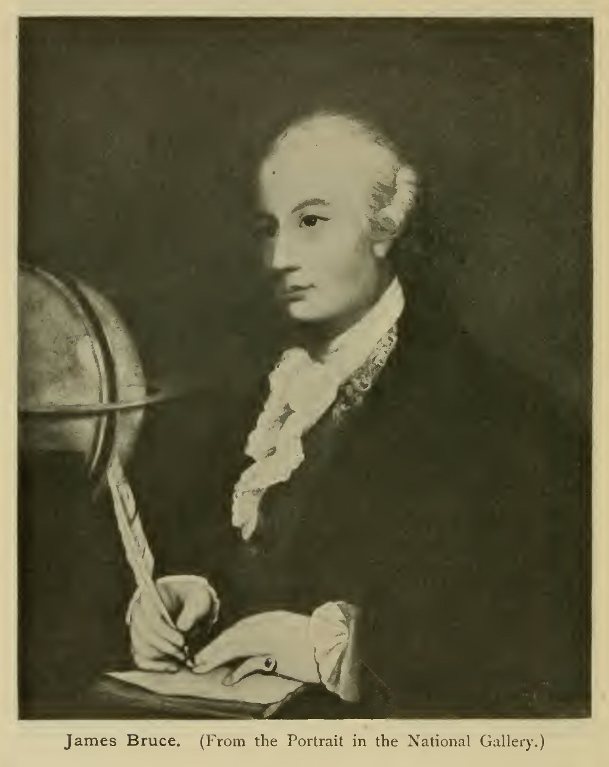
James Bruce. (From the Portrait in the National
Gallery.)
At Cairo, Bruce secured the countenance of Ali Bey, lately restored to power after many vicissitudes of fortune, and obtained letters of recommendation to the authorities in Upper Egypt, as also from the Greek patriarch to the Greek Christians in Abyssinia. Having completed his preparations he procured a Nile boat of the kind known as canja, and set out to ascend the river on December 12, 1768. A successful voyage, during which he noted the various antiquities passed en route, brought him to Syene (Assuan), whence, after fixing the latitude and visiting the first cataract, he returned to Keneh in order to take the desert route to the Red Sea at Kosseir. This journey was made in company with a mixed and disorderly caravan. At Kosseir, besides fixing the latitude, he obtained a longitude by observations of Jupiter's satellites, and, after a coasting trip to the "Mountain of Emeralds" (without finding any trace of these gems), hired a vessel to convey him down the Red Sea to Massaua, the final starting-point for the journey into the interior.
The voyage in this native craft was by no means a luxurious one. It began with a circuit of the northern end of the Red Sea, and a visit to Tor on the south-west coast of the Sinai peninsula, after which the vessel coasted down the Arabian side, touching at various points en route. At Jidda Bruce found a number of English merchantmen, and though his poverty-stricken appearance secured him but a doubtful reception at first, the merchants made up for the mistake, and on leaving he was honoured with a salute from all the ships. During his stay he obtained valuable letters of recommendation from the Sharif of Mecca, and from his chief Minister, Metical Aga—himself a native of Abyssinia, and a man of considerable influence on both sides of the Red Sea. The support of this ally proved invaluable in the sequel. From Loheia, further down the coast—after a trip to the Strait of Bab-el-Mandeb—the voyagers crossed over by the Dhalak archipelago to Massaua on the African side of the Red Sea, the passage being signalised by the supposed appearance of a ghost on board, by which the crew were much terrified, and by the running of the vessel on a reef, from which however it was happily got off without serious damage. Massaua was reached on September 19, 1769, and Bruce thus found himself on the threshold of the most serious part of his enterprise.
In the further prosecution of his task Bruce was faced by many obstacles. The rapacious and overbearing character of the petty chief of Massaua more than once threatened a catastrophe, and the difficulties were by no means over when he was at last fairly started for Gondar. The steep ascents of the plateau escarpments, first by the pass of Taranta to the highlands of Tigre, and afterwards by that of Lamalmon to the still higher plateau on which Gondar is placed, were exceedingly arduous, the transport of the large quadrant for astronomical work proving especially troublesome. As the strongest of the party the traveller took a personal share in the labour. The country too was in a disturbed state owing to the campaign then in progress between the old General Ras Michael (acting on behalf of the young King Tecla Haimanout, whom he had set up after deposing two others) and the insurgent Fasil. Arrived in safety at the capital, Bruce was favourably received by the Queen-mother, and his services as physician were soon requisitioned, several members of the Royal household being ill with small-pox. The success of his treatment procured him her patronage throughout his stay in Abyssinia. On the return of the King and Ras Michael, he was received in audience, and, according to his own account, as a step towards the execution of his task, was granted the governorship of the province of Ras-el-Fil, containing the source of the Blue Nile of which he was in quest. But a favourable opportunity for travelling thither was long in coming. The traveller's health declined, and he retired for a time to Emfras, on a hill overlooking Lake Tsana, whence he paid a visit to the cataract of Alata—on the Blue Nile below its exit from the lake—which had already been described by the Jesuits. He afterwards joined the King and Ras Michael during an expedition across the Nile against Fasil, but this proved disastrous and ended in a disorderly retreat. By a sudden volte-face, however, Fasil made his peace with the King, and this gave the traveller the chance he had been waiting for so long, as the insurgent chief dominated the country about the Nile source. After witnessing the retirement of the King and Michael to Tigre, he set out once more from Gondar on October 28, 1770, proceeding at once to Fasil's camp with letters of recommendation. His reception was at first anything but satisfactory, but his bold front impressed the chief, who became suddenly gracious, and gave him the facilities he required, binding his Galla subordinates by a solemn obligation to forward the traveller's wishes in every possible way, and giving him his own horse as a token of his protection.
Starting on November 2, and passing through a beautiful country, Bruce once more crossed the Nile above its entrance into Lake Tsana, finding it a rapid stream nearly 100 yards wide, and four feet deep in the centre. It forms a cataract in this neighbourhood, but this was found to have a height of barely 15 feet. The route now led towards a gently rising hill, near the top of which was the church of St Michael of Geesh. From this spot the traveller's eyes were at last gratified by the sight of the fountains, whence, beside a hillock, of green sod, the Blue Nile has its first small beginnings. Casting off his shoes in deference to the feelings of the natives, who regarded the spot as possessing a special sanctity, he rushed down the flowery slope and, standing by the principal fountain, indulged the feelings of rapture induced by the thought that he had at last gained the prize for which he had laboured so long.
Bruce flattered himself that he had thus solved the ancient mystery of the Nile sources, though on the one hand he was not the first European to visit the fountains of the Blue Nile, and on the other he had done nothing at all to unveil the far more remote sources of the White Nile. But in once more describing to the world the hydrography of a portion of the Nile system which plays a part of prime importance in the general regime of the river and its inundations, he had performed a service of distinct value, if not of the unique importance he was inclined to claim for it. Now that his task was accomplished his one wish was to set out on his homeward journey, but on returning to Gondar he found himself condemned to weary waiting owing to the continued political disturbances. At last, in December, 1771, over a year after his return from the Nile source, he was able to set out by the land-route to Egypt through Sennar.
Descending the western escarpment of the Abyssinian highland, through a thickly wooded country, the traveller joined in a grand battue held by one of the royal princes, and was treated to a display of the methods of elephant-hunting of the Arab swordsmen known as Agagir. Reaching Sennar after some adventures, he found himself surrounded by enemies, whose intrigues thwarted him at every turn, and it was only by selling a good part of the gold chain given him by the Abyssinian king that he at last procured the means of continuing his journey. The passage of the dreaded Nubian desert proved well-nigh disastrous, the small party coming near suffocation by the parching simoom, being overwhelmed by moving pillars of sand, or perishing of thirst after the water-supply had given out. They struggled into Assuan (Syene) after abandoning most of their impedimenta, but by sending back a party Bruce was able to rescue the precious notes and observations made during his extensive journeyings. The further journey to Cairo was accomplished without serious difficulty, the Egyptian capital being reached on January 10, 1773.
Although Bruce had made few if any positive geographical discoveries, his journey was important, by reason of the general attention it attracted in Europe, as a stimulus to further interest in African exploration, to be seriously taken in hand not many years later. And his narrative, published some time after his return, in spite of occasional exaggerations and embellishments, has remained one of the most striking pictures of exploration that have come down to us. The strangeness of some of the details caused the whole, quite undeservedly, to be viewed with suspicion by his contemporaries, whose verdict has however been reversed by later generations. The five bulky volumes in which it originally appeared embody, if in somewhat undigested form, a large amount of information on the history and manners of the Abyssinians, as well as on the geography of their country.
The only other part of Africa where exploration made any great headway during the eighteenth century was the extreme south. Here, after long forming merely a port of call for Portuguese, English, and Dutch ships en route for the East Indies, the Cape had at last begun to be settled by the Dutch about the middle of the previous century, farms being established for the supply of provisions to the ships. The arrival of the French Huguenots in 1688 had an important effect in necessitating the occupation of new land, while the desire to escape the exactions of the Dutch East India Company's officials led the "burghers" (as the settlers were termed in distinction from the officials) to push farther afield than at first. Even in the seventeenth century some attention had been paid to exploration pure and simple. In 1655 Jan Wintervogel had carried out an expedition to the north, and the work was continued by Gabbema and others in 1657-8. In 1660 the governor Van Riebeck sent out a party to seek for the empire of Monomotapa, which previous maps had so misplaced as to encourage the belief that it lay at no great distance from the Cape. The expedition, which was headed by Jan Danckert, passed the Olifants River, but returned without advancing any great distance beyond. A somewhat greater advance northward was made in 1661 by two parties under Pieter Cruythof and Pieter van Meerhof, and both of these went on a second expedition in 1662, during the course of which they came upon representatives of the Bushmen—that wandering race from whose treacherous attacks the colonists had afterwards to suffer so much. Another noteworthy expedition was that of Lieutenant Hieronymus Cruse, eastward to Mossel Bay, in 1668. But the most famous journey was that of the governor Simon van der Stell in 1685. It occupied five months and the European personnel amounted to over 50, with native followers in proportion. The principal object was the discovery of the copper district of Little Namaqualand, which it succeeded in reaching, returning by a different route along the west coast.
In spite of these efforts, the greater part of the South African interior, even south of the Orange River, remained virtually unknown at the opening of the new century, during the course of which a more decided advance was to be made.
Quite early in the eighteenth century some attention was turned to the south-east coast, as offering a possible field for settlement, and especially for the supply of timber to the more sparsely-wooded west. An expedition was sent to Natal by sea in 1705 in the Postlooper, with Theunis van der Schelling as master, but it accomplished little. In 1720 a Dutch fort was established on the coast of Delagoa Bay, which had been abandoned by the Portuguese some years before. The bay was sounded and charted, and some attempt made to explore the neighbourhood, but the settlers had to encounter many obstacles. In the hope of finding a way to the reported gold fields of the interior, an expedition under one Jan Mona started inland in 1725, but it was attacked by the natives and forced to return without penetrating any great distance. Of land expeditions from the Cape during the early part of the century one deserving mention is that of Hermanus Hubner, who in 1736 led a strong party of elephant-hunters eastward towards the Kafir country on the south-east coast. It was important as one of the first which brought the Dutch into contact with the Bantu tribes of the east, their previous intercourse having been almost entirely with the Hottentots. The party seems to have reached the lands of the Xosas, Tembus, and Pondos,[1] by whom they were at first received with friendliness, but on reaching the Xosas on the return journey a treacherous attack was made on Hubner's section of the expedition, and he and all with him were massacred, and the waggons burnt. The rest, though pursued, succeeded in making their escape, and on reaching Cape Town gave the authorities an account of their journey.
[1 The last are spoken of as "Nomotis." Among them three Englishmen were found living like natives.]
Although this expedition had advanced farther east than any previous one, it was of an unofficial character, and the geographical information it brought back was far from precise. But under the energetic administration of Governor Tulbagh, which began in 1651, exploration was more actively supported by the government, and some important results were gained. An elaborately organised expedition was despatched eastward early in 1752 under August Frederik Beutler, supported by an escort of soldiers, as well as by two surveyors, a botanist, various artificers, and others. It was in all respects the best-equipped expedition that had left the Cape down to that time. The Gouritz River was crossed, Mossel Bay passed, and on April 5 the last settlement towards the east, a short distance beyond the Little Brak River, was reached. Crossing the mountains, the expedition traversed the valley known as the Long Kloof, running east between two ranges, and reached the sea at the present St Francis Bay. The party now kept more or less close to the sea, examining the shores of Algoa Bay and crossing the Great Fish and other rivers. Early in June, the boundary between the Hottentots and Bantu, at the Keiskama River, was passed, and the country became more thickly peopled. The scene of Hubner's massacre was passed, but the force was sufficiently strong to command respect. The Kei was crossed on July 3, and friendly intercourse established with the Tembu chief Tzeba. The fatigues experienced now began to tell, both on the men and the oxen, so after advancing a few days longer in a north-easterly direction, it was decided, on July 10, to turn back.
During the return journey, a somewhat more inland route was adopted, for a part of the way, than on the outward march, and some new country, inhabited by Bushmen, was passed through. The Fish River valley was ascended for some distance, but the country here was suffering from a severe drought, and both grass and trees were burnt up. The explorers therefore turned once more towards the sea, and while some took a direct route to the Cape, the leader, according to instructions, endeavoured to find a bay reported to exist in the neighbourhood where Knysna lagoon has since been found. He did not reach its shores, but gave up the attempt and was back in Cape Town early in November.
This achievement marks the farthest advance eastward for many years, and subsequent efforts were for some time directed rather to the north and north-east. It is not certain when the largest South African river—the Orange—was first reached, but at any rate it seems to have been first crossed in 1760, by a settler named Jacobus Coetsee, who went north with a party of Hottentots to hunt elephants, and gained intelligence of the black-skinned Damaras ("Damroquas", as he heard them called) some distance beyond his turning-point. This adventure led the way to further advance in the same direction, for, Coetsee's story having come to the ears of a militia officer, Hendrik Hop, the latter made a successful application for the command of an exploring expedition, which included the surveyor Brink, the botanist Auge and the surgeon Rykvoet, the last also taking charge of the mineralogical work. A start was made on August 16, 1761, from a point near the mouth of the Olifants River, the whole caravan numbering over 80 persons, including 13 who accompanied the party as settlers. Passing the Copper Mountains, visited by the great expedition of Van der Stell in 1685, the expedition reached the Orange River at the end of September, and, crossing it, held on a northerly course between 18° and 19° E. long, and reached a point probably in about S. lat. 26°. The heat and scarcity of water then made it necessary to turn back, and some time was spent on the banks of the Orange, where a sudden flood during the night of January 11, 1762, placed the party in some danger. While among the "Great" Namaquas north of the river enquiries were made as to the peoples of the region beyond, and intelligence seems to have been gained, under the name "Briquas", of a section of the great Bechuana tribe. Giraffes were seen to the north of the Orange, and the skin of one was brought back.[1] The expedition was back in April, having achieved a considerable measure of success.
[1 It was sent to the Museum at Leyden by the Governor, and was the first to find its way to Europe.]
The expedition of Governor Van Plettenberg to the north-east and east in 1778 had political rather than geographical aims, though it led through some of the less-known border districts in the directions specified. The next important contributions to geographical knowledge were due to British travellers—Captain (afterwards Colonel) Robert J. Gordon, a Scottish officer who had taken service with the Dutch, and Lieutenant William Paterson, who came to the Cape in order to satisfy his bent for travel and natural history studies in a new country. Their journeys were made partly in company, though some of the more important results were due to Gordon alone. Both arrived at the Cape during 1777—Gordon (who, according to Paterson, had already travelled a good deal in the interior) as second in command of the Cape garrison. They left Cape Town in company on October 6, and went somewhat north of east up the valley of the (eastern) Olifants River—the upper course of the Gouritz. Arrived near its source, Paterson, who was suffering from ill-health, decided to stay behind, while Gordon proceeded north-east, through the Bushmen's country, towards the Sneeuwberg. In this, as in his subsequent journeys, Paterson paid especial attention to the botany, getting together a valuable collection of South African plants, but also securing specimens of the birds, etc. Gordon crossed the Sneeuwberg and reached the Orange River near the junction of its upper course with the second main branch—the Vaal—which he seems to have been the first to locate on the map. He was unable, however, to find a ford, and so returned without crossing to the northern bank.
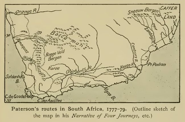
Paterson's routes in South Africa, 1777-79. (Outline
sketch of the map in his Narrative of Four Journeys,
etc.)
Paterson set out again in May, 1778, and this time had the company of a young Dutch gentleman, Mr Van Reenen, member of a family which owned several farms in the interior, and which subsequently showed considerable enterprise in the way of exploration. The two travellers experienced some difficulty from the snow-covering of the mountains, but by making a circuit to the east across the Karroo reached the Roggeveld, and then went somewhat west of north till they struck the Orange in its lower course, after experiencing a trying time in crossing the sandy desert south of it. They crossed the river by swimming, and Paterson, besides engaging in his usual botanical researches, secured a number of beautiful birds, while Mr Van Reenen shot a giraffe. The return was in a generally southward direction through the copper district already well known to the Dutch, Cape Town being reached on November 20. A month later Paterson again set out, intending now to visit the Kafir country on the extreme eastern borders of the Colony. He was again accompanied by Van Reenen, and succeeded in advancing some distance beyond the Great Fish River, though the waggon could not be taken on during the last stages owing to the thickness of the bush. Paterson claims to have been the first European to have penetrated into the Kafir country, meaning, no doubt, the first of European birth, as the colonists had already gone a good deal beyond his turning-point.[1] The return journey calls for no special remark.
[1 Dr Andrew Sparrman, the Swedish naturalist who accompanied Capt. Cook during the first voyage of the Resolution, had also visited the borders of Kafir-land, and his general account of his South African travels, before and after that voyage (1772 and 1775-6), forms one of the most important items in the literature of South African travel in the eighteenth century, though he did little actual exploration.]
After three months, i.e. towards the end of June, 1779, Paterson was ready to set out again accompanied by Sebastiaan Van Reenen,[2] a brother of whom, Jacobus by name, subsequently joined the party too. This fourth journey led nearly due north and was made for the most part in company with Colonel Gordon (as he now was), whom Paterson joined on the banks of the Green River, near the Kamisberg. The usual difficulties from want of water and grass were encountered, and various members of the party had unpleasant experiences through losing their way in the desert, but they came safely through in the end. The Orange River was at last reached on August 17, the unwonted greenery and abundant water-supply making it seem to the travellers a new creation after their nine days' transit across an arid and sultry desert. Colonel Gordon had brought a boat, which he launched the same evening at the river's mouth, hoisting Dutch colours and giving the river the name which it has since generally borne in Europe, in honour of the Prince of Orange. Excursions were made in the neighbourhood, and on the 25th the party set out eastwards, ascending the valley of the Orange for some distance through a barren hilly country. On the 29th they left the river, returning southward to recruit at a Dutch homestead, but again going north to examine a part of the river above that previously visited. Paterson and Gordon soon separated, the latter going east, while Paterson and Van Reenen crossed the Orange and went north-east, through a country still barren and hilly, in which a specimen of the giraffe was secured. On October 21 they re-crossed the river, and Paterson made the homeward journey in leisurely fashion, investigating the botany of the country. He was back at Cape Town on December 21.
[2 It does not appear from Paterson's narrative whether this was the same member of the family as had been his companion previously.]
By these several journeys a fair general knowledge of the lower course of the Orange, for a considerable distance from the sea, had been gained.
Another traveller from Europe—the French naturalist Le Vaillant—visited the Cape the year after the journey just described, and travelled extensively in the interior. He made a first journey in 1780-82, visiting the borders of the Kafir country and returning from the Sneeuwberg across the Great Karroo; and a second in 1783-85, during which he went north across the Lower Orange.[1] His graphic narratives are perhaps the best known of all the similar works on South Africa which appeared during the eighteenth century, but they have been generally regarded as not entirely trustworthy in matters of detail. The Dutch, whose exploring activity (if we except the work of Colonel Gordon, a Scotsman by birth) had been somewhat in abeyance during the 'seventies and 'eighties, again showed some enterprise during the last decade of the century. One of the Van Reenens, Willem by name, who owned a farm on the Olifants River, came forward in 1791 and undertook an expedition to the north with a view of testing the truth of the idea that gold was to be found in the desert region north of the Orange River. With several Dutch companions, including one Pieter Brand, he started in September, 1791, crossed the Orange in November, and pushed on beyond the farthest point reached by Hop 30 years earlier. At a mountain occupied by Namaqua Hottentots, with whom a collision took place, a camp was formed, and exploring trips in the surrounding country were undertaken. The mountain, which Van Reenen named Rhenius after the then Governor at the Cape, seems to have been somewhere near the latitude of Walvisch Bay. Brand went 15 days farther north, through country occupied by a branch of the Damaras (dark-skinned Bantu people) who had been subjected by the Namaquas, and seems to have met with representatives of the wild tribe since known as Hill Damaras. The camp at Mount Rhenius was shifted in March, 1792, but a further halt of some weeks was made not far off, in a locality where game was abundant. The waggons having been loaded with ore—in reality copper, but thought at the time to contain gold—the return march was begun, and, further investigations having been made on the way, Van Reenen's farm was safely reached in June, 1792.
[1 In the map accompanying Le Vaillant's narrative of his travels, the distances traversed were greatly exaggerated. Thus the route followed on the first journey is extended to the neighbourhood of Natal, and that on the second to the tropic of Capricorn, though Barrow (see below) showed reason for believing that he had not advanced beyond the Orange River. Not content with finding many new species of birds, Le Vaillant brought back a number of "faked" species—tail of one kind, wings of another, etc. Many of these were found out long after his death on being remounted.]
This expedition had done more than any previous one to throw light on the country and peoples north of the Orange River, but, not content with what they had accomplished, the Van Reenens applied to the authorities for aid in a new venture. Two of the family, Sebastiaan and Dirk Gijsbert van Reenen, obtained a passage in the government vessel Meermin, commissioned to take possession, on behalf of the Dutch East India Company, of various points on the coast of Great Namaqualand, north of the Orange—a coast hitherto unclaimed, though for some time frequented by whalers. Before the Meermin sailed, a land party had been despatched under Barend Freyn, who had taken part in Willem van Reenen's expedition, and had heard of the existence of a friendly Hottentot chief named Ynemand. He set out before the end of 1792 with orders to try to reach this chief's residence; the Van Reenens' plan being to land on the south-west coast, and, pushing inland, to effect a junction with Freyn. The first point touched at by the Meermin was the island since known as Possession. Here the Company's flag was hoisted, and the ship proceeded to the neighbourhood of Angra Pequeña (a locality which came into prominence a century later in connection with the German occupation of this coast). where explorations were carried out without any trace of Freyn being met with. The voyage was therefore continued to Walvisch Bay, where Pieter Pienaar, a member of the Van Reenens' party, was sent to explore inland. He returned after three weeks with no tidings of the land expedition, which, as it afterwards turned out, had found the excessive drought an insuperable obstacle to an advance. It was therefore decided to return, and beyond a partial examination of this inhospitable strip of coast, whose moving dunes have stood in the way of thorough exploration down to our own day, no very important geographical results were gained.
This was the last serious attempt at northern exploration under the Dutch regime, for the political events at the close of the century, which ended in the British occupation of the colony, engrossed the attention of the government. After the surrender to the British, a journey of considerable extent through the interior was made by Mr (afterwards Sir John) Barrow, who had been sent out officially in connection with the establishment of the new government. Barrow's narrative, published in two parts in 1801 and 1804, long remained one of the most used sources of information on South Africa, though the ground traversed by him had already, for the most part, been made known by previous travellers. His farthest in the interior was at a point on the Upper Orange River, beyond the Sneeuwberg, and above the junction with the northern tributary, the Vaal. This was the only portion of his route which led him much beyond the limits of the country settled by the Dutch.
The journeys described in this chapter had resulted in a fair
general knowledge of the interior up to the line of the Orange
River, and had shed some light on the tracts immediately north of
its lower course. They constituted a stage in the progress of
exploration in South Africa, and it was not until well on in the
next century that a further decided step forward was made,
leading to the unveiling of the more distant interior up to and
beyond the Zambezi.
III. Arctic.
In the first chapter of this book we spoke of the great period of Arctic Exploration which began about 1550 and was characterised, firstly by the search for a northern passage to the East Indies, and secondly by the whaling enterprise in the northern seas, chiefly around Spitsbergen. During the whole subsequent period, between the first quarter of the seventeenth and the last quarter of the eighteenth century—i.e. for about a century and a half—a pause in Arctic discovery ensued, and so little had been effected that material for a continuance of the story has been almost entirely lacking. The early activity had been called into play by practical considerations, and when it had been virtually established that no feasible route for trade purposes existed in the far north, the inducement to continue the struggle was in great measure removed. Two or three voyages from this intermediate period must, however, be referred to before touching upon the Arctic occurrences of later date.
Among the voyages of the Dutch whalers and walrus hunters subsequent to 1625, the one which has attained most celebrity is that of Willem de Vlamingh in 1664. According to the statement of Witsen, this bold seaman, during a voyage to Novaya Zemlya, rounded the northern extremity of the group, and passing near the scene of Heemskerk's and Barents's distressful wintering on the east coast, sailed E.S.E. to a point in 74°, where he saw nothing but open water. It is sometimes stated that De Vlamingh visited the winter quarters of the earlier Dutch voyagers, but as no mention is made of the house there erected (which was still standing in the latter half of the nineteenth century), it is probable that no landing was made on this side of Novaya Zemlya. Another statement of Witsen, on which implicit trust cannot be placed, is to the effect that in 1700 Captain Cornelius Roule had sailed north in the longitude of Novaya Zemlya and had sighted a previously undiscovered land. As has been so often the case in Polar voyages, it is probable that a bank of fog had been mistaken for land. Various rumours were also current at this time, in Holland and elsewhere, that ships had either sailed right up to the Pole itself, or had made the voyage from Japan to Europe across the Polar basin, reaching a latitude of 84°. But all such statements, like the similar claim said to have been made by Mandeville three centuries earlier, are obviously purely imaginative.
Partly through trust in these statements, and partly from a study of the voyages of Barents and other early navigators, and from theoretic considerations, an Englishman, Captain John Wood, put forward a scheme for a voyage through the polar sea in search of a passage to Japan and Tartary, which he thought would most probably be found midway between Spitsbergen and Novaya Zemlya, as the ice, in his view, would cause most obstruction near a coast-line. Having obtained the support of the King, the Duke of York, and other influential persons, he sailed in 1676 with two ships—H.M.S. Speedwell and the Prosperous pink—the latter in command of Captain William Flawes. But the voyage was unfortunate. Unbroken ice was found to bar the way wherever a passage was attempted, and the ships could not advance beyond 76° N. Encountering stormy weather and thick fog in the ice off the coast of Novaya Zemlya, the Speedwell ran on a rock on June 29 and was lost, the Prosperous narrowly escaping a like fate thanks to her smaller size. Wood and his men got to land with great difficulty, and found themselves in almost hopeless case until providentially rescued by Captain Flawes. The result was entirely to shatter Wood's belief in the chances of a passage, and to make him brand as intentionally misleading the reports which had seemed to favour such a possibility. Naturally, nothing further was done to prosecute the search.
Another voyage of this period deserving mention is that of the German surgeon Frederik Martens, who in 1671 visited Spitsbergen, and wrote an excellent account of that ice-bound land, on which it long remained the standard authority.
From the early part of the 18th century the only voyage to this part of the Arctic regions which calls for notice is that of the Dutch whaling captain, Cornelis Gillis or Giles, to the north-east of Spitsbergen in 1707. In this year the sea appears to have been particularly free from ice in these parts, for Gillis was able to pass the latitude of 81° to the north of the Seven Islands, and then sailed east in an open sea until, bending his course to the south-east and south, he came, in 80°, to new land that was not again sighted for over a century and a half. It must have been the White Island of modern navigators, lying between Spitsbergen and Franz Josef Land, which forms an inaccessible mass of snow-covered land. Gillis is said to have returned through Hinlopen Strait, and did not therefore complete the circumnavigation of the Spitsbergen group. He seems to have made accurate surveys of its coasts, though little was known of his voyage until, nearly 70 years later, his papers fell into the hands of the English writer, the Hon. Daines Barrington, and so attained publicity.
Of the Arctic voyages during the eighteenth century some have already been spoken of in chapters dealing primarily with other parts of the world. The Russian surveys on the north coast of Siberia have been described in Chapter x, while in dealing with Captain Cook's voyages it was necessary to pass from the Pacific to the Arctic Ocean in telling of the attempt to push north through Bering Strait which formed one of the main tasks laid down in the programme of the third voyage. Again, certain attempts from the side of Hudson Bay have fallen naturally into place when speaking of the exploration of Northern Canada. One or two other efforts at northern discovery during our period remain to be mentioned here. None was in itself of great importance, but one at least—that of Captain Phipps in 1773—marks a new start in Arctic enterprise, and may be regarded as constituting to some extent a preliminary stage of the great Arctic campaign of the nineteenth and early twentieth centuries.
It was once more to the initiative of a private individual that the impulse in this direction was due. The Hon. Daines Barrington, a son of Viscount Barrington and brother of a distinguished admiral and also of a bishop, having turned his attention to the subject of Arctic voyages, collected all the information thereon that he could lay hands on, and placed it before the Royal Society with a view to showing that the attainment of the North Pole itself was quite a feasible project. This was perhaps the first time that this object was held out as something to be striven for in itself, the earlier Arctic ventures having almost invariably been undertaken with some practical and commercial aim in view. The age of scientific exploration was now beginning, and the scheme set on foot by Barrington was but one out of many manifestations of the spirit of enquiry now abroad, which, as we have seen already, found its opportunity during the period of peace ushered in by the Treaty of Paris in 1763. As a matter of fact Barrington's information was far from trustworthy, but he succeeded in interesting the Royal Society in the matter, and, this body having approached the King through the Earl of Sandwich, the despatch of a Government expedition was resolved upon.
The command was entrusted to Captain Constantine Phipps (afterwards Lord Mulgrave), who sailed in the Racehorse, while a second ship, the Carcass, was placed under the command of Commander Lutwidge. Both vessels were of the kind technically known as bombs, and were therefore unusually strong and specially suited for ice-navigation. They were fitted out with great completeness, and, among other appliances, their equipment included the apparatus for distilling water invented by Dr Irving, who sailed in the Racehorse as surgeon.[1] The ships left Deptford towards the end of May, 1773, finally sailing from the Nore on June 10. After some delay from unfavourable winds and fogs, the expedition was off the south part of Spitsbergen before the end of the month, the weather remaining mild. The land was sighted on the 29th in about 77° 59' N., being composed of high black rocks, with snow-filled valleys. Continuing their northerly course past Magdalena Hoek, the navigators reached the ice-field on July 5, and now began a vain attempt to find a passage through it. At first they pushed through the looser ice towards the north-west, but on the 9th, having reached by their reckoning Long. 2° 2' E. in about Latitude 80° 36' N., found the main field to form a compact impenetrable body, and therefore turned eastward once more. After anchoring on the 13th at Vogelsang near the rocky point called the Cloven Cliff, they made successive attempts to push east or north, but in vain. In the former direction the ice joined the land, while to the north, in about Lat. 80° 37' N., it ran in an unbroken line from east to west. Passing in sight of the Seven Islands, the ships reached the mouth of Vaigatz Strait, where one of the boats had an adventure with a number of walruses. The weather was delightful and the sea smooth, but the ice soon began to close round the ships. It was feared that they would not get clear, and preparations were made for abandoning them, but thanks to a favouring wind they were forced through on August 10, and once more reached open water. In view of the lateness of the season, Captain Phipps now decided to return, and after a favourable passage reached the Nore on September 25. The results of the voyage were purely negative the ice having apparently offered an unusually solid barrier, though the weather conditions had been favourable. Little encouragement was therefore forthcoming for a renewal of the attempt, and no further effort to push north by this route was made for some years.

Constantine John Phipps, Earl of Mulgrave.
(From the portrait in the National Gallery.)
[1 Apart from its geographical significance, the expedition is noteworthy from the fact that the future hero, Horatio Nelson, served in it as a midshipman.]
Somewhat farther west, on the south-east coast of Greenland, an isolated attempt at exploration was made before the end of the century by a Danish expedition—one of the many about this time which enjoyed Royal patronage, King Christian VII of Denmark taking a personal interest in it. In spite of this advantage the expedition met with but little success. It was despatched in 1786 under Captain Lowenorn and Lieutenant Egede, with the object, besides other exploration, of searching for the old colony supposed to have existed in Eastern Greenland many years before, but long lost sight of. The voyagers encountered great obstacles in the masses of ice which beset the Greenland coast and which entirely barred access to it in the latitudes within which the attempt was made—roughly between 65° and 67° N. The ships returned to Iceland, whence Egede made a second, equally fruitless, effort to reach the land later in the same summer. He wintered in Iceland and returned to the task, accompanied by Lieutenant Rothe, in May 1787, but was forced to turn back. In June he started once more, but the obstacles still proved too formidable, and he was obliged to abandon the attempt, without accomplishing anything in the way of actual exploration. It was not until well on in the nineteenth century that any real progress towards a knowledge of Eastern Greenland was made. Its coast is perhaps more persistently ice-bound than any other part of the Arctic regions, rendering its exploration a matter of exceptional difficulty.
From the American side of the Arctic regions an abortive attempt at further exploration had been made a few years before this (1776-77) in connection with Cook's third voyage, the intention being to prepare the way for the return of that navigator, should he have been successful in finding a passage from the Pacific to the Atlantic by the far north. In 1776 Lieutenant Richard Pickersgill was sent by the British Admiralty in the armed brig Lion, primarily for the protection of British whalers in Davis Strait, but, this task accomplished, he was instructed to make a survey of Baffin Bay in view of a proposed repetition of the voyage in the following year. The Lion left Deptford on May 25. On June 29 soundings of 320—330 fathoms were struck in the North Atlantic in 57° N., 24° 24' W.—a position roughly corresponding to that in which the imaginary Busse Island of Frobisher had been placed on the charts, and this submarine bank was taken by Pickersgill to represent the remains of that island. On July 7 Cape Farewell was passed, and on the 8th the Lion became entangled in the ice-field off the south-west coast of Greenland. The commander now made the mistake of clinging too closely to this coast, and the ice drifting along it made progress slow. By August 3 he had only reached 65' 37' N., though by moving out into the central channel between the two ice-fields he was able to make much better progress the next day, and reached 68° 37' N. But he now lost heart and decided to turn back, though practically nothing had been done towards carrying out the intended survey.
The Lion was sent out again the next year in command of Lieutenant Walter Young, who was instructed to explore the western coasts of Baffin Bay, searching for inlets which might offer hopes of a passage westward. If any such were found, an attempt was to be made to push on in that direction. Nothing of the kind, however, was accomplished. Cape Farewell was reached early in June, but on entering the ice-pack stormy weather was encountered. In spite of this, the latitude of 72° 42' N.—considerably higher than had been attained the previous year—was reached on June 8, but, the channel between the ice-fields on either side having then become extremely narrow. Young gave up all attempts to prosecute the objects of the expedition, and returned homewards, reaching the Nore on August 26. Thus ended the last serious attempt for many years to push northward by the Baffin Bay route.
{Page 407}
A rapid view may now be taken of the main characteristics and phases of exploration during the period dealt with in this volume. Opening with the retirement of Spain and Portugal from the position of chief actors in the drama, its early stages were marked by the rising activity of the Dutch and English in the maritime struggle for the eastern trade; of the French in the exploitation and partial settlement of northern North America; and of the Russians in the conquest of the wide plains of Siberia. In none of these cases did exploration for its own sake form the ruling motive of the pioneers by whom these conquests were achieved, but incidentally to the quest for commercial advantages much was done to extend the bounds of geographical knowledge. From the point of view of general world-knowledge the most notable achievements during the first half of our period were the voyages of Tasman, which did more than any others to draw back the veil from the previously unknown Australasian area; and the various Arctic voyages of the Dutch and English in search of the north-east and north-west passages.
After about the middle of the seventeenth century maritime discovery entered, temporarily, upon a less active phase, though the doings of the Buccaneers helped to extend acquaintance with the South Seas, though mainly confined to certain definite routes. The name of Dampier stands out among the rest as most meritorious from our point of view. Land exploration owed much at this time to the energy of the Jesuit and other missionaries in various parts of the world, especially in Spanish, Portuguese, and French America, in all of which they showed themselves active as pioneers in the wilds beyond the limits of regular settlement.
About the middle of the eighteenth century may be said to have begun the modern period, par excellence, of geographical discovery, which has continued with no decided break to our own times. Exploration was now first definitely undertaken with scientific, rather than commercial aims. After the conclusion of the Treaty of Paris in 1763, expeditions for research purposes were inaugurated on all hands, investigations into the natural history of the regions visited being combined with survey-work of a more precise character than had previously been undertaken. The transit of Venus in 1769 supplied the incentive for some of the most important exploring work of the century, being the immediate cause of the despatch of the first of Cook's famous expeditions, as well as of the series of research expeditions carried out by Russian savants in Siberia. Elsewhere, too, exploration began to take on a more scientific character, as evidenced in the work of men like David Thompson in the west of Canada.
Glancing now at the regional extension of exploring work during the seventeenth and eighteenth centuries, it may be said that the most marked characteristic of the whole period was the unveiling of the great Pacific Ocean, which down to the end of the sixteenth century had been traversed by one or two routes only, the greater part of the area remaining entirely unknown. By the close of the eighteenth century its waters had been covered with a complete network of routes, and all the important island groups had been laid down on the charts with an approach to accuracy, while the last of the unknown continental coast-lines bounding the same ocean had been surveyed—in some cases, as by the work of Vancouver in North-West America, with a high degree of precision. Land exploration during our period had shown the most decidedly new departures in the case of northern North America and Northern Asia, which, practically unknown to civilised man at its opening, had before its close taken their place among the regions of the world of which at least the major features had been laid down on the maps. In other parts of these continents some extension of previous knowledge had been brought about, though the central core of Asia still remained to a great extent a terra incognita. In Africa only the fringe of the vast interior had been touched before the close of the eighteenth century, while in the case of Australia all but the coast-line remained absolutely unknown. The North and South Polar Regions had also been touched only on their outskirts. The exploration of these, and of the interior of Africa and Australia (and to a smaller extent of Asia), remained as the special tasks of the nineteenth century.
Although, as we have said, the contemporary period may be considered to stretch back, in its opening stages, to considerably before the end of the eighteenth century, yet that point of time, which has been taken as the limit of this volume, does mark a real epoch in the history of geographical exploration. The general distribution of sea and land, and the contours of the great land masses within the habitable portion of the globe, had then first become matters of definitely established knowledge.
{Page 410}
Chapter I. Dutch North-East Voyages (pp. 25, 30). The fame of Barents has so over-shadowed that of his associates in the quest for the North-East Passage that there is perhaps a risk of giving these less than their due of the credit for the results gained. The reputation of Rijp in particular has, in the opinion of some, suffered somewhat unjustly for this reason. While Barents held to the route by Novaya Zemlya, Rijp saw more chance of success by keeping to the open sea, and it was with this idea that he made his determined effort to push north through the Barents Sea east of Spitsbergen. Some, even of Barents' companions, seem to have doubted the wisdom of his course of action, as has been pointed out by the Dutch historian, Dr S. Muller. Rijp's experiences were of some importance in connection with the renewed attempts in 1611-12, under Jan Cornelisz. May, of which mention should have been made in the text. Like so many Arctic voyagers, Rijp had been misled into thinking that he had sighted land (named by him Fish Island) at his farthest north, and it was the verification of this supposed discovery that formedone of the special tasks assigned to May.
This voyager, known to his contemporaries by the sobriquet "Menscheter" (man-eater), has remained less known than he deserves to be, no doubt from the fact that his Arctic journal has only lately been made generally accessible. He had already commanded a ship in Van Neck's voyage to the East Indies in 1598, and was afterwards captain of Spilbergen's ship on his voyage of circumnavigation in 1614-17. The idea that a course through the open Polar sea might meet with less obstruction from ice than one which hugged the land held its ground even after Hudson's failures to find a passage, and it had the influential support of Plancius, among others. It also received some encouragement from a book brought out in 1610 by a German doctor, Helisaeus Röslin, under the title Mitternächtige Schiffarth. The actual project for a new voyage was put forward by two private adventurers, Ernest van de Wall and Pieter Aertsz. de Jonge, who after one or two vain attempts persuaded the States General—urged thereto largely by the representations of Plancius—to fit out two ships for the venture (January 1611). In order to avoid the drift-ice it was urged that the voyage should be made as early in the year as possible, and preparations were therefore hurried forward. The commander was to sail in the Vos, while his colleague, Symon Willemsz. Cat, was appointed to the Craen. The pilots were Pieter Fransz. and Cornelis Jansz. Mes, and the two projectors sailed as factors—Van de Wall in the Vos, De Jonge in the Craen. May's nephew Jan Jacobsz. May also sailed with him. The ships left the Texel on March 28, 1611, passed the North Cape on April 14, and began their search for a passage between Spitsbergen and the supposed Fish Island of Rijp. But the ice offered an insuperable barrier, as was also the case on a second attempt between the supposed Fish Island and Novaya Zemlya. Nor were they more successful on once more trying Barents's old route along the coast of Novaya Zemlya. It was therefore resolved to pass to the second part of the programme, the examination of the coast of North America (Nova Francia). Sighting Newfoundland on October 29 they sailed south along the coast, searching for harbours and entering into some traffic with the natives, though this was marred by a fatal affray. The most southerly point reached seems to have been south of the Hudson, in 40° 35' N., and some of the names given to features on this coast held their ground in later maps.
Early in 1612 it was resolved that the Craen should remain on this coast while May in the Vos renewed the attack on the ice-fields. Conditions were even worse than in 1611 and though on two successive attempts to sail N.W. from Novaya Zemlya latitudes of 77° and over were attained, the voyagers had again to own themselves beaten. The Vos was back in Holland early in October, the Craen having already arrived in July.
A geographical result of the voyage was the elimination from the map of the various lands placed conjecturally in the space between Spitsbergen and Novaya Zemlya—"Willoughby's land", "Matsyn", and "Fish Island." An indirect result was the further prosecution of enterprise by companions of May, both in the Arctic sea and on the American coast. On one of the voyages, carried out in 1614 by the younger May with Joris Carolus (see p. 44) as pilot, the island of Jan Mayen was visited, and it is to the commander on this occasion that the island appears to owe its name, and not, as was once thought, to his uncle. It has been held by some that it was then first discovered, though the belief in the identity of the island with "Hudson's Tutches" (see p. 28) seems a reasonable one, while the island may also have been visited by others before 1614. The voyages to the American coast had an important result in the founding of the Dutch "Compagnie van Nieuw Nederland", the forerunner of the Dutch West India Company.
Chapter V. Early Jesuit Journeys to Tibet (p. 131). A good deal of misconception has hitherto prevailed on the subject of Andrade's journey to Tibet, but the actual facts have been clearly stated by Mr C. Wessels in an article in De Studien (Nijmegen), 1912. Misled by the identity of name between the chief place in Garhwal and Srinagar in Kashmir, some have supposed that the journey led through the latter country, which is quite a mistake. It has also been held that the traveller made his way to Lake Manasarowar, but this seems equally erroneous. The only body of water spoken of by him is a tanque or pool at the source of the Ganges, which, according to the latest information, does actually exist. There is also no foundation for the statement that Andrade continued his journey across Northern Tibet to China. After reaching Chaprang for the second time he spent several years in missionary work there, and after he left his labours were continued by other missionaries. Another Jesuit, father Cacella, appears to have reached Shigatze in south central Tibet in 1627, and to have been succeeded on his death in 1630 by Father Cabral. After 1650, the Jesuit missions in Tibet ceased for over 60 years. Except the above missionaries, no traveller is known to have visited the source of the Ganges or to have crossed the western Himalayas until the nineteenth century.
Chapter VIII. Spanish Discovery of the Caroline Islands, 1686-1733. While, as has been seen in Chapter viii, the English circumnavigators usually held to a more or less definite track across the Pacific, passing one or other of the Ladrone Islands, something was done during the same period by the Spanish authorities to bring to light the small scattered islands to the south of that group, since known as the Carolines. The first discovery is said to have been made in 1686, when a Spanish ship commanded by Don Francisco Lazeano lighted upon a "large island" which he named Carolina in honour of the reigning king of Spain, Carlos 11. The Ladrones had by this time been occupied by Spain, and about 1688 the governor Quiroga sent an expedition to search for this island, but without result. In 1696 the island Faroilep is said to have been discovered by a pilot, Juan Rodriguez, between 10° and 11° N.—a latitude which corresponds better with that of Falalep, considerably further west. Further information was gradually acquired—in part from the reports of natives carried from their homes by storms—and the idea of establishing a mission in the islands took shape among the Jesuits of the Philippines, who gave the name New Philippines to the new discoveries, and sent to Europe information about them which was printed in the Lettres Édifiantes. The first attempts, including one in 1710, under Don Francisco Padilla, accompanied by Fathers Duberron and Cortil, led to no result; but eventually Father Juan Antonio Cantova, a missionary who had previously been stationed at Guam and had thence collected more definite information than had been before available, made his way to the Carolines in 1722; visiting, so far as can be made out, the group east of Yap known as Garbanzos. He returned with a colleague in 1731, but two years later was murdered by the inhabitants of Mogmog, near Falalep.
Chapter IX. French and Spanish Voyages in the Pacific, 1769-74. The English enterprise in the Pacific from 1764 onwards, and the reports of discoveries resulting therefrom, led indirectly to several voyages by navigators of other nations, in addition to those mentioned earlier in this book. One of these, under Jean François de Surville, was organised in 1769 by the French in Bengal in the hope of exploiting for purposes of trade the reported English discovery of a large rich island in the Central Pacific—a report probably based on a distorted version of Byron's or Wallis's discoveries. The voyage, made in the Saint Jean Baptiste, was disastrous. Contrary winds made it impossible to advance far in the required southerly direction, and the voyagers were reduced to great straits by attacks of scurvy and the lack of fresh water. After sighting Juan Fernandez, and at length reaching the coast of Peru, their misfortunes culminated in the loss of their commander by the capsizing of a boat. Just at this time the Spanish authorities were viewing with jealous eye the British doings in the Pacific, and the Viceroy of Peru, Don Manuel de Amat y Junient, had obtained permission to fit out an expedition to search for and occupy the long reported Davis's Land, by some identified with Easter Island, visited by Roggeveen in 1722. Two ships of war were fitted out and placed under the command of Don Felipe Gonzalez, who sailed in the San Lorenzo, while the frigate Santa Rosalia had as captain Don Antonio Domonte. The expedition sailed from Callao on October 10, 1770, reaching Easter Island on November 15, The island was formally annexed to the Crown of Spain under the name San Carlos, and a survey carried out; while, on leaving, a search for other land to the west was made. Only in 1908 was this voyage rescued from oblivion by the care of Dr Bolton Corney, by whose researches several imprinted documents bearing on it had been unearthed.
The Spanish authorities followed up this voyage by others, all with Tahiti as their destination; but little information about them has yet been made public. During Cook's visit to Tahiti in the course of the second voyage, news was obtained of the visit of a Spanish vessel early in 1773, which has been wrongly thought to have been that commanded by Don Cayetano de Langara y Huarto (who did not sail till 1775). In reality the first two voyages were made by Don Domingo Bonechea, who sailed on the first in 1772. Having returned to Peru, he again left Callao in the frigate Santa Maria Magdalena (or Aguila), accompanied by the despatch vessel San Miguel, on September 20, 1774; Tahiti being reached on November 15 of the same year. A considerable stay was made there, and a good deal of information on the island is contained in a journal kept by the interpreter Maximo Rodriguez, of which a MS. copy is in the possession of the Royal Geographical Society. This too Dr Corney hopes shortly to publish for the first time, like that of Gonzalez, under the auspices of the Hakluyt Society. Bonechea died at Tahiti.
Chapter XIII. Exploration on North-West Coast of Hudson Bay, 18th century (pp. 329-330). Some additional details on this subject may here be given. The voyage of Christopher Middleton in search of a western passage by this route has been spoken of on p. 329. Its results were not considered satisfactory by Dobbs, who in a heated controversy with Middleton maintained that the desired passage was still probable. Funds were raised for a new expedition, which sailed in 1746 in the ships Dobbs and California, Captains William Moore and Francis Smith respectively, the former of whom had taken part in Middleton's expedition as Captain of the Discovery. Mr Henry Ellis also sailed with the commission to chart the anticipated discoveries, and he eventually wrote the narrative of the expedition. Having wintered near York Factory, the ships sailed north in 1747 and explored the coast. Moore and Ellis in the Dobbs's long-boat discovered Corbett's Inlet, while Smith in the California attempted to enter Rankin's Inlet (discovered by Lieut. John Rankin of the Furnace in 1742). Subsequently the two long-boats continued the exploration in company and discovered the most important inlet of the whole coast—Chesterfield Inlet—which received its name on this occasion. It was ascended for a long distance, its width fluctuating between three or four and six or seven leagues. But though it seemed to open out at the farthest point reached, the explorers "were discouraged from proceeding farther, because that the water from being salt, transparent, and deep; with steep shores, and strong currents, grew fresher, thicker, and shallower, at that height." After this the ships went north again to examine the so-called Wager Strait; but finding it to be a bay only, they gave up the task and sailed for England.
The main chance of finding a westward passage now lay in the further exploration of Chesterfield and Corbett's Inlets, and for this purpose Captain Christopher was sent north in 1761 in the Churchill. He is said to have ascended Chesterfield Inlet for about 100 miles, but then turned back as the water had become almost fresh. Returning next year accompanied by Mr Norton he pushed on to the freshwater lake into which the Dubawnt river debouches; but without seeing this. The lake received its name. Baker Lake, on this occasion. In 1764 Rankin Inlet was explored by Captain Johnson, whose surveys, like those of Christopher, are embodied in a MS. chart preserved at the Admiralty.
The despatch in 1790 of Captain Charles Duncan—the same whose voyage to N.W. America is referred to on p. 281—was due to the solicitations of Alexander Dalrymple, who urged on the Hudson Bay Company the possibility of still finding a passage by way of Roe's Welcome. Reaching Hudson Bay in 1790 Duncan found so much obstruction put in his way that he returned without doing anything. In 1791 he was sent again in a new ship, the Beaver, but was so delayed by ice in Hudson Strait that he could do nothing beyond carrying out an examination of Corbett's Inlet to its head. In 1792 he went in the Beaver to Chesterfield Inlet, which he then ascended by boat, proceeding on through Baker Lake to the river which enters at its head. It had been part of his commission to trace the supposed connection between this river and the outlet of Dubawnt Lake discovered by Hearne; but finding the river to come for some distance rather from the north than the west, he gave up the attempt after tracing it upwards some 30 miles. With this voyage all efforts to prosecute the search ceased for the time.
Chapter XIV. Dutch Exploration in
Guiana, 18th century. During this century much
enterprise was shown by Dutch traders and prospectors in pushing
into the interior of their colony of Guiana, especially during
the vigorous administration of the Governor Storm van 's
Gravesande, whose despatches were first printed in 1911 by the
Hakluyt Society under the editorship of Messrs Harris and De
Villiers. They show that a considerable knowledge of the
geography and peoples of the interior, up to and beyond the
borders of Brazil, was possessed by the authorities. From about
1740 onwards miners pushed up into the Upper Essequibo region in
search of ores, while a Treatise on the Posts, written by Storm
in 1764, shows that traders regularly made their way by the
Essequibo and Rupununi to the interior savannahs, and that some
had advanced down the Takutu and Rio Branco as far as the
Portuguese Missions. Documentary evidence has lately been brought
to light showing that the journey to the Rio Branco had been made
as early as 1718 by a Jew named Gerrit Jacobs. The claim of a
mining prospector, Salomon Sanders, to have ascended the Corentyn
to its source in 1720, seems not to be trustworthy, though he
probably advanced some distance up that river.
Chapter XV. The French in Madagascar, 18th century. A renewal of French activity in this great island during the latter part of the 18th century brought about some additions to knowledge. In 1750 a concession of the island of Ste Marie off the north-east coast was obtained on behalf of the Compagnie des Indes, and in 1768 Fort Dauphin was re-occupied by M. de Modave for the French government. Among scientific travellers who visited Madagascar about this time, besides Commerçon and Sonnerat (see p. 224), were M. Poivre and the Abbé Rochon. In 1774 the Hungarian adventurer Benyowski, who had gained the countenance of the authorities, established a settlement on Antongil Bay, but, being eventually disavowed, he entered upon a career of lawlessness which ended in his death in 1786. The most important travels in the interior were those of one Mayeur, interpreter at the French establishments, who between 1774 and 1785 traversed the northern part of the island to the Sakalava country, visited the northern extremity, and made two journeys to the Hova province of Imerina. His accounts were not entirely superseded until the end of the nineteenth century.
{Page 417}
Note. Names of Ships are in Italics.
Abai River, Abyssinia, shown on Fra Mauro's map
described by Paez
Abendroth Island, Pacific
Abreu, Antonio Fernandez de, discovers mines in Mato Grosso
Abrus precatorius, seeds of
Abyssinia, Le Blanc's travels in
Jesuit and other intercourse with
Fra Mauro's knowledge of
Jesuits expelled
Capuchins and others try to establish Mission
mistakes of cartographers respecting
journeys to, by Nile
(Krump's)
Bruce's journeys in
anticipated by Jesuits
his descent of western escarpment
his description of
Academy of Sciences, Paris
geodetic operations of
Acapulco, Anson at
Malaspina at
Acapulco Galleon, buccaneers lie in wait for the
smaller, taken by Woodes Rogers
Accault, his journey with Hennepin
Achani tribe, Amur
Acuña, Cristoval d', voyage down Amazon and narrative
Adair, trader to Ohio
Adams, William, takes part in Dutch voyage to Japan
his residence there
meets Saris
voyages to Siam
Adanson, French botanist, patron of Gmelin
Aden, lessened importance of
Admiralty Islands, N. of New Guinea, named by Carteret
Hunter at
French uniforms seen at
D'Entrecasteaux at
Adua, Abyssinia
Adventure, sails on Cook's second voyage
parts company
rejoined by Resolution in New Zealand
scurvy on
again separated
at Queen Charlotte Sound
disaster to boat's crew and voyage home
Adventure Bay or Sound, Tasmania, Cook at
D'Entrecasteaux at
Africa, knowledge of, A.D. 1600
Le Blanc's travels in
17th cent. exploration in
18th cent. exploration in
interior almost unknown in 1800
Africa, North, Bruce's travels in
Africa, South, early travels in
exploration in, 17th and 18th cent.
position in 1800
Africa, West, travel in, 17th cent.
slave trade in
De Gennes touches at coast
(see Gambia, Sierra Leone, Senegal, etc.)
African Galley
wrecked
Agagir elephant hunters
Agau countries, visited by Lobo
Agra, visited by Sharpeigh
by Coryat
by Mandelslo
Goes starts from, for China
Grueber reaches
Aguarico River, Upper Amazon basin
Aguila
Aguirre, descent of Amazon by
Ahmetkent, Gmelin dies at
Aigle, Bouvet's ship
Bougainville's ship
Aigun, station of, Amur
Ainus of Yezo, Vries hears of
Aitutaki Island, S. Pacific
Ajmere, Jehangir's court at
Akbar, Emperor, merchant from China at court of
Aksu, E. Turkestan
Alaba, Galla-land
Alaseya River, Siberia, reached by Russians
Alashan range, Mongolia
Alaska, Cook on coast of
Gvosdef reaches coast of (map)
Bering and Chirikof on coast of
fur-traders in
explorations on coast of, by La Pérouse
by British fur-traders
by Malaspina
British sovereignty proclaimed by Vancouver
white men's visits to, reported to Mackenzie
(see America, N.W.)
Alaska penins., Cook at
Bering at
Alata, cataract of, Blue Nile
Bruce visits
Alava, José, Spanish representative at Nootka
Albaca or Albay, Philippines, eruption of
Albanel, Father, reaches Hudson Bay from South
Albany, voyage to Hudson Bay
Albay volcano, see Albaca
Albazikha River, Upper Amur
Albazin, Upper Amur, founded
sieges of
Aldan River, Siberia
Aleppo, overland route to east from
Aleutian Islands, Cook explores
Russians in
Bering sights volcanoes of
Russian trappers in
Billings and Sarichef in
Alexander, voyage in W. Pacific
Alexeief, Feodot, voyages on N.E. coast of Siberia
Alfred, King, Other's voyage narrated to
Algiers, Bruce consul-general at
Algoa Bay, reached by Beutler
Algonquins of Canada
Ali Bey, ruler of Egypt
Alleghanies, a barrier to advance westward
Walker crosses
Boon crosses
Aller, Julian de, his work among Moxos
Allouez, Father, journeys in Canada
Almeida, Manoel d', History of
Abyssinia
Altai Mts, Gerbillon hears of
Pallas's researches in
Alvarez, embassy of, to Abyssinia
Amapalla Bay, Cent. America
Amatafu Island, see Tiafu
Amat y Junient, Don Manuel de
Amazon River, Roe's visit to
early explorations in basin of
descent by Spanish Missionaries
ascent by Teixeira
Acuña's work on
connection with Orinoco
Dutch and English on
Fritz's account and map
journeys in basin of, 18th cent.
descent by La Condamine
by Madame Godin
Amazons, supposed female warriors
Ambuina, English and Dutch at
Funnell at
D'Entrecasteaux at
Ambrose, —, with Dampier in Cygnet
Ambrym Island, New Hebrides, Cook sights
America, recognised as an independent land-mass
strait between Asia and;
importance of Jesuit journeys in
America, Central, buccaneers in
America, North, knowledge of, A.D. 1600
explorations in, 17th cent.
position of western extremity
Vancouver disproves idea of sea-passage across
land exploration in 18th cent.
French in
exploring activity in
Dutch on N.E. Coast
America, North West, proposed exploration by Narborough
Cook's voyage to ascertain relations with Asia
Spanish voyages to
supposed island off extremity of
Bering's and Chirikof's voyages to
Russian trappers in
Ismaelof and others explore
La Pérouse on coast of
voyages of fur-traders to
Vancouver's surveys
(see Alaska)
America, South, knowledge of, A.D. 1600
discovery in, 17th cent.
black-water rivers of
buccaneers on coasts of
French on west coast of
Malaspina's surveys on coasts
18th cent, explorations in
political boundaries in
Amgun River, Lower Amur
Amoenitates Exoticae, title of work by Kaempfer
Amossof, Feodot, explorations off N. Siberian coast
Amoy, Clipperton at
Amphitrite, voyage to China
Amsterdam, Indian goods distributed from
Arctic ventures of merchants of
Amsterdam, voyage of the
Amsterdam Island, Indian Ocean, De Vlamingh passes
Crozet sails for
Vancouver misses
position fixed by D'Entrecasteaux
Amsterdam Island, Pacific
Amu Darya, old bed examined by Bekovich
Amur River, Russians on
main stream navigated by Poyarkof
Khabarof's voyage
explorations in upper basin of
lower basin evacuated
crossed by Jesuits from China
Academicians on Upper
mouth not reached by La Pérouse or Broughton
Messerschmidt on Upper
Pallas on
Anaa, Low Archipelago
Anabara River, Siberia
Anachorètes, Île des, New Guinea
D'Entrecasteaux at
Anadyr River, Siberia, expedition in search of
reached by Deshnef
sea-route to, not used
Paulutzki on
route to Kamchatka by
reached by Laptef
Anadyrsk station founded
Anamocka or Anamuka Island, see Namuka
Anchorite Island, see Anachorètes
Ancient Mariner, Rime of the
Anderson, Mr, sails with Cook
Andes, geodetic operations in
Andrade, Antonio de, journey through Tibet
Andrean
Andreief, journey of, in Siberian Arctic Sea
Angara River, reached by Russians
Angasija, Comoro Islands, Beaulieu's account of
Angelis, F.A. de, missionary in Abyssinia
Angelis, — de, Jesuit in Japan
Angelo and Carli's journeys in Angola
Angoche Island, S.E. Africa
Angola, Remetszoon's voyage to
Angostura, Orinoco
Angra Pequeña, S.W. Africa, Van Reenens at
Anian, supposed Strait of
Knight's voyage to discover
Anikieffs, Russian merchants
Ankudinof, voyage of, with Deshnef
Annapolis basin
Anne, The, sails under Anson
condemned
Anson, Lord, voyage round world
Antarctic, field for discovery
Cook on borders of
exploration abandoned
Antarctic Circle, first crossed by Cook
further crossings
Antongil bay, Madagascar, French at
Antwerp, Indian goods distributed from
Anuda Island, Pacific, discovered by Edwards
Anville, J.B. d'
see D'Anville
Anza, Juan Bautista de, searches for route
California
Api Island, New Hebrides
Apollinaire, Brue's agent on Senegal
Apolobamba, Peru
Aquiluna or Aquilonda, supposed lake
Arab sword-hunters
Arabia, Middleton in
visited by Le Blanc
early intercourse with
Niebuhr's journeys in S.W.
his work on
Bruce on coast of
Araguaya River, Brazil
Aratika Island, Low Archip.
Arce, Father de, work among Chiquitos
journeys in Paraguay, and death
Archangel Michael, Spangberg's ship
Archithinue (Blackfeet) Indians, Hendry meets
Arctic Circle, crossed by Hearne
Arctic Ocean, early voyages in
suggested route to Pacific through
Cook attempts to navigate
Clerke repeats attempt
islands in, off Siberian coast
Russian voyages in
reached by Hearne
by Mackenzie
Arctic regions, beginnings of exploration of, II
exploration in, 17th and 18th cent.
importance of Dutch and English voyages
Ardrah, W. Africa
Arend, Roggeveen's ship
Argonaut, voyage to N.W. America
Argun River, Upper Amur
fort on
Messerschmidt on
Arimoa Island, New Guinea
Arizona, Spanish Missions in
Arkansas River, Marquette and Joliet near
Joutel reaches
Arkansas tribe, in
Arkiko, Red Sea
Armenia, Père de Rhodes in
Grueber in
Arnhem
Arnhem's Land
Arteaga, Ignacio de, exploration on W. coast of N. America
Artieda, Andres de, descends Amazon with Teixeira
Aru Islands, touched at by Duifken
by Carstensz. and Pieterszoon
Arzina, Lapland, Sir H. Willoughby perishes at
Ascenção Island of Frézier
Ascension Island, Dampier at
De Gennes at
Bougainville at
Ascension
Asia, knowledge of, A.D. 1600
relations of, with N. America
N.E. extremity, Cook at
(see Deshnef, Cape)
Asia, Central, early knowledge of
18th cent, journeys in
Renat's
his map
Asia, Northern, in Mercator's map of 1569
17th cent, advance in
Strahlenberg's map and description of
exploring activity in
Asia, N.E. coasts, Dutch discoveries on
Russian ditto
La Pérouse's exploration of
Broughton's voyage to
(see Kamchatka)
Asia Minor, Coryat visits
Père de Rhodes in
Bruce in
Asnaf Segued, Emperor of Abyssinia
Assiniboiles, Lac des
Assiniboine Indians, with La Vérendrye
Kellsey visits
Hendry among
Assiniboine River, exploration of
Assistant, sails under Bligh
Assomption Island, Ladrones
Assuan, Bruce at
Astrabad, Gmelin at
Astrakhan, Gmelin at
Guldenstaedt at
Astrolabe, sails under La Pérouse
Asuncion, Paraguay
Asuncion Island, Ladrones
Atabapo River, Venezuela
Atafu Island, Pacific, Edwards at
Atbara, head-stream crossed by Brevedent
Athabasca, Lake, not the Athapuscow of Hearne
tidings of
reached by Pond
misplaced by him
fort founded on
crossed by Mackenzie
survey by Turner
Athabasca River, descended by Pond
Athapuscow Lake (Great Slave L.), discovered by Hearne
Atiu Island, see Watiu
Atjeh, Sumatra, Houtman killed at
Lancaster at
Beaulieu at
Dampier at
Atlantic Ocean, supposed connection with Pacific
Atlantic Ocean, South, reports of land in
Bouvet's search for land in
Vancouver's search for Ilha Grande in
(see Circumcision, Cape)
Atlassof, Vladimir, expedition to Kamchatka
Atrevida, voyage of, under Malaspina
Attok, Indus
Atui Island, Sandwich group, Cook at
Vancouver at
Atures, cataract of, Orinoco River
Auge, botanist on Hop's expedition, S. Africa
Augustinians in Peru
Aurora Island, New Hebrides
Aurungzeb, Bernier physician to
Austral Islands, S. Pacific
Cook at
Australia, discovery of, in 16th cent., doubtful
Dutch voyages to
proved an independent land-mass
north-west coast explored by Tasman
later Dutch voyages to
Dampier's visits to
De Vlamingh's voyage to
east coast unknown before Cook
explored by him
Vancouver's survey of S. coast
Broughton touches at
decision to found penal settlement in
Bligh on coast of
D'Entrecasteaux surveys S. coast
interior unknown, 1800
Austrialia del Espiritu Santo, of Quiros
Bougainville identifies
Avacha bay, Kamchatka
La Pérouse at
Avogadro, Jesuit on Rio Negro
Avondstond Island, Pacific
Ayuthia, Siam, English factory at
Azara, Don Felix de. South American traveller, portrait, etc.
surveys Spanish-Portuguese boundary
further work
his Scientific Memoirs
Azevedo, João de Sousa e, journey in S. Brazil
Azevedo, Marcos de, discovers silver and emeralds in Brazil
Azores, longitudes observed by Cook at
Baalbek, Bruce visits ruins of
Bab-el-Mandeb, Strait of, Bruce at
Babylon, ruins visited by Della Valle
Bac, see San Xavier del Bac
"Backwoodsmen" in American Colonies
Badakshan, Goes in
Baddan, Nepal
Badrinath, Andrade passes
Baffin, William, North-West voyages of
voyages to Spitsbergen
takes longitude by lunar distance
death at Ormuz
Baffin Bay, reached by Davis
explored by Baffin
Cook's search for passage from Pacific to
Pickersgill and Young in
Baffin Land, discovered by Frobisher
Baghdad, Delia Valle at
Bahia, Pyrard at
taken by Dutch, and retaken
Dampier at
Bahuida Steppe
Baie Française (Bay of Fundy)
Baie Française, Strait of Magellan
Baikal, Lake, reached by Russians
crossed by Beketof
Gerbillon's information on
De la Croyère at
crossed by Pallas
Bailey, William, astronomer on Cook's third voyage
Bailul, Red Sea
Baker, Joseph, with Vancouver
Baker Lake, Canada, discovered
Baku, Gmelin at
Bakundi tribe, W. Africa
Balambangan Island, Borneo
Balbi, Gasparo
Baltimore, Lord
Ball, Lieut., sails to N.S. Wales with Phillip
voyage to Norfolk Island
to Batavia
Ball's Maiden Land, W. Pacific
Bambara, W. Africa
Bambuk, gold of, W. Africa
attempt to reach
reached by Compagnon
Banda, Keeling at
search for new route to
Banderas, Bay of, Mexico
Banks, Sir Joseph, accompanies Cook
botanical collections in New Zealand
in Australia
in New Guinea
portrait of
intended participation in Cook's second voyage
supports despatch of Bounty
secures restoration of Labillardière's
collections
Bantam, Houtman reaches
Lancaster at
principal English factory
investment by Dutch
Bantu of S. Africa, Dutch contact with
Baranof, Great Cape
Baraze, Cypriano, work and travels among Moxos
murdered
Barbela River, Congo
Barbinais, Le Gentil de la, voyage across Pacific to China
Barbola, Lake
Barbosa, Duarte
Barbot, James, Voyages to Calabar and Bonny
Barbot, John, description of Guinea
Barclay, Capt., voyage to N.W. America
Barclay Sound, Vancouver Island
Bardelière, Michel Frotet de la, Eastern voyage of
Barents, Willem, his map of the North
Hondius's map of his discoveries
a pupil of Peter Plancius
Arctic voyages of
tries to pass Yugor Strait
favours route to north of Novaya Zemlya
wintering there with Heemskerk, and death
winter-quarters passed by De Vlamingh
Barfrush, Persia, Gmelin at
Barker, Andrew, voyage to Greenland
Barontala, Tibet
Barrakonda and falls, Gambia
Barren Lands, Canada, expeditions to
Barrington, Hon. Daines, publishes account of Gillis's voyage
urges Arctic exploration
Barros, João de, on avoidance of South coast of Java
on Portuguese in Timbuktu
Barrow, Sir John, Journeys in S. Africa
Barsa Kilmas Lake, Central Asia
Bashi Islands, China Sea
Bass Strait, Islands in, seen by Furneaux
Basse des Frégates Français
Bassendine, agent of Muscovy company
Bassora, Persian Gulf
Basundi tribe, Congo
Batavia, founded
Dampier at
Funnell at
Roggeveen at
Wallis at
Carteret at
Cook at
new route to Canton from
Shortland at
Hunter at
Ball and King at
(see Jacatra)
Batavia
Batchelor's Delight
Batchelour, sails under Narborough
Bateke country, Congo
Batta, François van, Journey in Congo
Battas, Duchêne, voyage to Chile and Peru
Bauman, —, sails with Roggeveen
Bauman Islands, Pacific, see Bouman
Baurenfeind, W., with Niebuhr in Arabia
death
Baures, Baraze murdered by the
later missions to
Baures River, Brazil
Baxa, see Buxa
Bay of Islands, New Zealand, Marion murdered at
Bay of Islands, N.W. America
Bear Island, discovered by the Dutch
Bear Islands, Siberia
Beauchêne, Gouin de, voyages of
Beaujeu, commands La Salle's ships
Beaulieu, Augustin de, voyages of
Beautemps-Beaupré, hydrographer with D'Entrecasteaux
"Beaux Hommes", N. America
Beaver, trade in skins of
Beaver, voyage of, to Hudson Bay
Beccari, work on Abyssinian History
Becharof, voyage to Alaska
Bechuanas, early reports of
Begon, "Intendant" in Canada
Behrens, Carl Friedrich, with Roggeveen
Beit-el-Fakih, coffee mart, Yemen
Beketof, ascent of Selenga River by
Bekovich Cherkaski, enterprises in Central Asia
Belem, see Pará
Beligatti, Cassiano, his journey to Lhasa
Bell Sound, Spitsbergen
Bella Coola River, British Columbia
Bellefond, Villault de, voyage on Guinea coast
Bellin, Nicholas, map of Bering Strait region
Bemmelen, W. van, chart of magnetic variation
Benares
Bencoolen, Dampier at
Benedict XII, Pope
Bengal, Pyrard's account of
merchants of, and American fur trade
and New Guinea trade
and Pacific exploration
Bhutanese invasion of
Beni River, Amazon basin
mouth passed by De Lima
Benin, knowledge of, A.D. 1600
Nyendael's account of
Bennet, Stephen, names Cherie Island
Benyowski, adventurer in Madagascar
Benzelstiern, copy of Renat's map by
Bering, Vitus
appointed to command exploring expedition
voyage through Bering Strait
fixes S. point of Kamchatka
new expedition
superintends other explorations
begins voyage
shipwreck and death
Bering Bay of Cook
non-existent
Bering Island, Bering's ship wrecked on
Bering Sea, Cook in
Russian hunters in
Bering Strait, early rumours of
said to have been discovered by Deshnef
Cook enters
Clerke in
Bering's exploration of
Bermudo, José, work among Moxos
Bernier, François, journey to India, and work
Bernizet, scientist with La Pérouse
Berrio, Antonio de
Best, Captain, victory of, at Swally
Betagh, William, captured by Spaniards
his account of Peru and Chile
Beutler, August Frederik, expedition in S. Africa
Bhatgaon, Nepal
Bhutan, missions from India to
Bichu River, Tibet
Bighorn Mts, possibly reached by La Vérendryes
Bihouda, see Bahuida
Bileth, Robert, see Byleth
Billings, Capt., expedition to Bering Strait region
Biscayans, employed in Spitsbergen whale fishery
Bison ("Buffalo"), of N. America, seen by Marquette and
Joliet
by Kellsey
by Hendry
by Escalante
Bissagos Islands, W. Africa
Bissao, W. Africa, visited by Brue
Biyurt, Senegal
Black water rivers of S. America
Blackfeet Indians, Canada
Blackwater River, British Columbia
Blaeu, maps of Africa by
Blanc, Vincent le, travels
Blanco, Cape, W. Africa
Bland lake, Canada
Blende, Father, journey in Paraguay, and death
Bligh, William, sails with Cook
voyages in Bounty and Providence to
procure bread-fruit tree
portrait
mutiny of his crew
perilous voyage home
surveys in Tasmania
Bluet, Mr, life of Job ben Solomon by
Bobé, Father, memoir on routes in Canada
Bocage, — du, voyage across Pacific
Bocarro, journey towards L. Nyasa
Bocca Tigris, Canton, Anson at
Bogle, George, mission to Tibet
death
publication of his journals
Bolcheretsk, Kamchatka
Bokange or Bocanga tribe, W. Africa
Bokhara, Russian advance towards
Bolivia, journeys on E. borders of
see Paraguay
Bomba Archipelago
Bombay, merchants of, and American fur trade
Bona Confidentia
Bona Esperanza
Bonaventura, Father, his journey in Congo
Bond, Lieut., surveys in Tasmania by
Bonechea, Don Domingo, voyages of, to Tahiti
Bonin Islands, discovery of
Bonjour, Father, begins survey of Yunnan, but dies
Bonny, Barbot's voyage to
Bonthein, Celebes
Booby shoal. Pacific
Boon, Daniel, crosses Mts into Kentucky
Borabora, Society Islands, Cook at
Borkhaya, cape, Siberia
Borneo, visited by Van Noort
E. India Co.'s establishments in
Bosman, Description of Guinea
Boscawen Island
Botany Bay, discovered and named
site of penal settlement
surveyed by Hunter
navigation to
Botany Island, New Caledonia
Boucan or dried meat
Boudeuse, see La Boudeuse
Boudoir, Le, peak, Tahiti
Bougainville, Louis Antoine de, Byron meets
early life
takes colonists to Falklands
voyage round world
Bougainville Island, Solomons, Bougainville at
Shortland at
D'Entrecasteaux's survey
Bougainville Strait, Solomon Islands
D'Entrecasteaux in
Bouguer, his geodetic work in S. America
Bouman Islands, Pacific
Boundaries, expedition of the, Venezuela
Bounty, voyage of the
mutiny on
Edwards's search for mutineers
their fate
Bounty Islands, Southern Ocean
Bourbon, Fort, Cent. Canada
Bourbon (Réunion) Island
Bourdon, Jean, expedition to Hudson Bay
Bourges, M. de
Boussole, La Pérouse's ship
Bouvet, Jesuit in China
Bouvet, Lozier, voyage to South Seas
its influence
on Cook's plans
Bouvet's South land. Cook's search for
not identical with Prince Edward Islands
Furneaux's search for
Bow Indians, N. America
Bowrey, Capt. T., chart of Tasman's discoveries by
Bracq
Brahmaputra, Upper, see Sanpo
Brak River, Little, S. Africa
Branco, Rio, N. Brazil
reached by Dutch
Brand, Pieter, journey north of Orange River
Brandenburgers in W. Africa
Bravo, Father, journey in California
Brazil, Pyrard wrecked on coast of
extension of knowledge of, 17th cent.
enterprises of the Paulistas in
Jesuit and Dutch journeys in
Nieuhoff's work on
Chatham sent with despatches to
pioneering in Central
boundaries of
Dutch reach, from north
Brazos River, Texas, La Salle on
Bread-fruit, attempt to introduce, into West Indies
Brébeuf, Jesuit Missionary in Canada
Breskens
Brest, La Pérouse sails from
D'Entrecasteaux sails from
Brevedent, Charles de, journey to Abyssinia
death
Brianta River, Siberia
Brieba, Domingo de, descent of Amazon
Brink, surveyor on Hop's expedition, S. Africa
"Briquas", S. Africa
Bristol, James's expedition fitted out at
British exploration in W. Canada
political results
occupation of Cape Colony
(see English)
Broken Bay, N. S. Wales
Broughton, W.B., sails with Vancouver
ascends Columbia, and goes home with despatches
second voyage to N. Pacific
Broughton Channel, Sea of Japan
Brouwer, Hendrik, voyage to Staten Land and Chile
Browne, —, agent of Muscovy Co.
Bruce, James, journeys of
in North Africa and Syria
reaches Egypt
portrait
fixes position of Kosseir and embarks on Red Sea
reaches Massaua
journey to Gondar, residence there, etc.
reaches Nile source, and starts home
perilous journey to Egypt
Brue, André, activity on the Senegal
Brugge, J.S. van der, winters in Spitsbergen
Brulé, Étienne
Brunei, Olivier, Northern voyages of
Bruni Island, Tasmania
Buriats, oppose Russians
Buccaneers, voyages of the
origin of name
narratives of
French
results of voyages of
Buenaventura, Tierra de la. New Guinea
Bueno, Bartolomeu, seeks for precious metals in Brazil
discoveries followed up by his son
Buenos Aires, overland trade of, with Chile
"Buffalo" of N. America, see Bison
Buffalo Lake, W. Canada
Buka, Solomon Islands
Bougainville at
D'Entrecasteaux's survey of
Bulkeley, —, gunner of Wager
Bungo, Japan, reached by Dutch
Bureya Mts, Amur
Bureya River, Lower Amur
Burhanpur, India
Burney, James, on Pacific voyages
sails with Cook
Burning banks of Mackenzie
Burrough, Stephen, Arctic voyage of
Burrough, William, chart by
instructions for Pet and Jackman
Burrough Strait
Buru Island, Malay Archip.
passage between Ceram and
Busa, Elisei, reaches Lena delta and explores Yana etc.
Busch, Henry, Dutch sailor in Siberia
Bushmen, encountered by Dutch explorers
Busse Island, supposed, N. Atlantic
Bustamante, J. de, sails with Malaspina
Butler, Capt., voyages in Pacific
Button, Sir Thomas, voyage to Hudson Bay
Buxa Duar, route to Bhutan by
Byleth or Bylot, Robert, with Hudson in 1610
voyages with Baffin and others
Byron, Commodore John, narrative of loss of Wager
voyage round world
search for Pepys Island
Byron Island, Pacific
Byron Strait, New Zealand
Caamano, Jacinto, surveys coast of N.W. America
Caaroans, Uruguay
Caborca mission station, Sonora
Cabot, Sebastian, voyages of
helps to found mercantile association
Cabral, Father, his mission to Tibet
Cabrillo, voyage on W. coast of N. America
Cacella, Father, missionary in Tibet
Cacheo, Brue's journey to
Cairo, Bruce at
Calabar, Old and New
Calcutta merchants fit out New Guinea Expedition
(see Bengal)
Caldeira, Francisco de, founds Pará
California, Shelvocke visits
Frondac on coast of
Vancouver on coast of
search for harbours in
California, Gulf of, supposed passage from head of
explored by Ugarte
by Consag
California, Lower, peninsular character known in 16th cent.
thought an island
missionary journeys in
Kühn's attempts to prove junction with continent
California
Calvert Islands, N.W. America, named by Duncan
Cambalik, see Chumbalik
Cambay, Gulf of, Sharpeigh at
Cambodia, Dutch in
Campeachy, Dampier in
Camus, geodetic measurement by
Canada, French in, 17th cent.
Cook's survey work in
18th century explorations in
western journeys by southern route
from Hudson Bay
cession to Great Britain
Canada, Western, outlines of geography completed
Canadian Pacific Railway, route of
Candish, Thomas, see Cavendish
Canga, Kwango River
Canja, a Nile boat
Cannibalism in New Zealand
Canoes, War, of Tahiti
Cañons of the Colorado
Canton, Shelvocke at
Anson at
new route from Batavia to
Cantova, Juan Antonio, missionary to Carolines
Cape Colony, beginnings of settlement of
explorations in
British occupation of
Cape of Good Hope, Beaulieu's stay at
Dutch settlement at, and visits to
route to East Indies by
Wallis's longitude of
Cook at
Marion Dufresne at
Vancouver at
British expedition against
Shortland and Hunter at
D'Entrecasteaux at
(see Cape Colony)
Cape Verde Islands
Cook touches at
Cape York Peninsula, see York, Cape
Captain Cook, trading ship, voyage of, to N.W. America
Capuchins in Tibet
in Abyssinia
Carabaya province, Peru
Caravellas, Rio das, Brazil
Carcass, Arctic voyage of
Carib way of drying meat
Carisfort, see Carysfort
Carli, journeys in Angola
Carlsen, Captain, visits Barents's winter quarters
Carlshof Island, Low Archip.
Carolina Island, discovered
Caroline Islands, Mortlock in
Duff's voyage through
Spanish discovery of
Carolus, Joris, explorations of, around Spitsbergen, and map
his voyage to Jan Mayen
Carpentaria, Gulf of, Duifken in
Carstensz in
circumnavigated by Tasman
Carrot River, Canada
Carstensz, Mount, New Guinea
Carstenszoon, Jan, Journal of
voyage to Australia
Carteret, Philip, voyage round world
discovers strait between New Britain and New
Ireland
his chart
Carteret group, Pacific
Carteret Island (Malaita)
Carteret's Harbour, New Ireland
Carthagena, Colombia
Cartier, Jacques
Carvalho, Jesuit in Japan
Carver, Jonathan, attempts western exploration in N. America
Carysfort Island, Pacific
Cassowary, brought home by Houtman
Caspian, journeys on and beyond, 18th cent.
Pallas's
Gmelin's
Cassiquiari River, S. America
Ramon's descent of
Castañares, Father, his exploration of Pilcomayo, and death
Castillo, José del, his work among Moxos
Castricum, see Kastricom
Castries Bay, Manchuria
Cathay (China), shown by Herberstein as "Lake Kythay"
Goes's search for
identical with China
(see China)
Catherine, Empress of Russia, patron of research in Asia
Caucasus, Guldenstaedt explores
Caura River, Venezuela
Cavazzi da Montecuccolo, his travels in W. Africa, and book
Cavendish or Candish, Thomas, route of, south of Java
Caverne, lie de la
Cecchi and Chiarini, their travels in Galla countries
Celebes, Dampier at
Carteret at
Celery, Wild, as preventive of scurvy
Celsius, aids French geodesists
Cenis Indians, Texas
Centurion, Don, search for El Dorado
Ceram, sea north of, unknown
Tasman's voyage to, and chart
passage between Buru and
Cerviño, Azara's assistant
Cespedes, Luiz de
Ceylon, Dutch trade with
Herbert visits
Mandelslo in
Chain Island, Low Archipelago
Chambers, Commander
Champlain, Samuel de, early career
suggests canal across American isthmus
undertakings in Canada
exploring journeys
portrait
death
Champlain, Lake
Jogues's description
Chanal, Capt., sails with Marchand
Chanal Island, Marquesas
Chancellor, Richard, sails with Sir Hugh Willoughby
journey to Moscow
drowned
Chanchamayu River, Peru
Chang-pei-Shan, Mts
Chaprang, Tibet, Andrade at
Chardin, Sir John, visits to the East
Charles II, supports Wood's Arctic voyage
Charles XII of Sweden, his officers sent prisoners to Siberia
Charles, Foxe's ship
Charles Island, Galapagos
Charlevoix, Father, his report on western routes in Canada
Charlotte, voyage from Sydney to China
Chastes, Aymar de
Chatham, sails with Vancouver
homeward voyage
Chatham, Cape W. Australia
Chatham Sound, N. W. America
Chaumont, Chevalier de, his mission to Siam
Chaves, Nuflo de, his expedition in Central S. America
Chechegin, supports Khabarof on Amur
Chekin, his explorations on Siberian coast
Chelyuskin, his explorations on Siberian coast
Chelyuskin, Cape, Siberia
Cherie Island (Bear Island), so named by Stephen Bennet
Chernigofski, founds Albazin
Cherry Island, Pacific
Chesapeake Bay, explored by Smith
Chesterfield Inlet, discovered and explored
Chiarini, see Cecchi
Chichiklik Pass, Central Asia
Chickahominy River
Chidley's Cape, Hudson Strait
Chieng-mai, Siam, English at
Chiloe Island, visited by Narborough
Shelvocke at
Frézier's account of Chonos of
Chilande, Lake, Angola
Chile, Dutch aim at opening a new route to
attempt to open English trade with
Betagh's account of, and of French trade with
French buccaneers on coast of
Beauchêne Gouin's voyage to
Feuillée's and Frézier's accounts of
La Pérouse on coast of
Vancouver ditto
China, attempted discovery of North-Eastern route to
Quast and Tasman to survey coast of
Western route to
land route to
European knowledge of
Mendoza's account of, and work of Jesuits in
Atlas Sinensis of Martini
Dutch Embassies to
Navarette's travels
Jesuits' overland journeys
their survey and map
Clipperton in
Anson in
French trading voyages to
voyages to N.W. America from
(see Great Wall)
China Strait, Torres at
De Prado's chart of
Chinese Calendar, reform of
Chinese Empire, Jesuit survey and map of
Chipewyan, Fort, founded
Mackenzie returns to
Chipewyans, Hearne joined by
Henry and others in country of
Chiquitos of Central S. America
Spanish missions to
search for route to
Chiriguanas of Paraguay
Chirikof, Alexei, Bering's colleague
commands St Peter
reaches American coast and returns
Chirikof Bay, N.W. America
Chitaingof, mate with Bering
Chittagong, Pyrard at
Choiseul Island, Solomons (q.v.)
Chonos, of Chiloe Island, Frézier on
Chosan, Korea, Broughton at
Christian IV of Denmark, patron of voyages
Christian VII, ditto
Christian, Fletcher, leader of mutiny on Bounty
Christianaux Lake, of Hendry, not Winnipeg
(see Cristinaux)
Christmas
Island, Indian Ocean, Minors's and Dampier's visits
Anson sights
Christmas Island, Pacific, Cook at
Chronometer, Vancouver's longitudes by
Chugatsk Bay, Alaska
(see Prince William Sound)
Chukches, N.E. Siberia, first heard of
visited by Ignatief
Cook visits
Shestakof's fatal fight with
Paulutzki's expedition to
Billings opposed by
Chukutskoi-nos, N.E. Siberia
Chumbalyk, shown in Herberstein's map
Chumbi valley, Tibet
Chunchos of Peru
Churchill River, Canada
fort near mouth
reached by Frobishers and Henry
Fidler's map
Churchill
Cinque Ports
Circumcision, Cape, discovered by Bouvet
Cook's search for
not identical with Prince Edward Islands
Furneaux's search for
Circumnavigators, see Chapters VIII, IX
Claaszoon, Haevick, his voyage to Australia
Clairaut, geodetic measurement by
Clarence Strait, N.W. America
Clark, George Rogers, march north of Ohio by
Clavius, Jesuit mathematician
Clavus, Claudius, early map of the North by
Clear Lake, Canada
Clearwater River, Canada
Clerke, Charles, second in command with Cook
assumes chief command
attempt to penetrate Arctic Ocean, and death
Clerke's Island, Bering Sea
Cleveland Bay, E. Australia
Clipperton, Captain, leaves Dampier and crosses Pacific
new voyage
return and death
Clove, voyage to Japan
Cloven Cliff, Spitsbergen
Coal, in Tasmania
Coburg peninsula, N. Australia
Cochin China, Père de Rhodes's labours in
Cocking, Matthew, journey on Saskatchewan by
Cocks, Richard, factor in Japan
Cocomas tribe, Peru
Cocos Islands, discovered
Tasman sails for
(see Kokos)
Cocos (Keeling) Islands, Dampier misses
Cod, Cape
Coen, Jans Pieterszoon, Dutch Governor in East
Coetivi, Chev. de, his voyage to East Indies
Coetivi Island
Coetsee, Jacobus, crosses Orange River
Cofanes Indians, Upper Amazon
Coffee trade in Yemen
Colbert, interests himself in Canada
Coleridge's Ancient Mariner
Collaert, Gerrit
Collingridge, George, reproduction of De Prado's charts
Collins, Grenville, with Narborough
Collins Cape, Spitsbergen
Colnett, James, voyage to N.W. America
put under arrest
Cape Ommaney named by
Colombia, route between Venezuela and
Colorado River, Grand Cañon reached before 1600
lower course reached and crossed by Kühn
mouth reached by Ugarte, effect of its water
Consag's attempted ascent
Garcés on
Escalante's journey across upper basin
river crossed on return
Columbia, American sloop in N.W. America
Columbia River, possibly visited by Heceta and Quadra
mouth seen by Meares
missed by Vancouver, but seen by Gray
examined by Broughton
Fraser identified with
Comanche Indians, W. United States
Commerçon, Botanist with Bougainville
Comorin, Cape, Saris's latitude of
Comoro Islands, touched at by Houtman
by Beaulieu
Compagnies Landt, Japan
Compagnon, Sieur, journeys in W. Africa
his map and descriptions
Companies, Trading and Chartered:
Danish E. India
Dutch W. India
English African
French African and W. Indian
French African
Dutch E. India
French Pacific
China
Russian fur-trading
Dutch New Netherlands
(see East India Co., Hudson Bay Co.,
North-West Co., etc.)
Company's New Netherlands
Compass, variation of
observed by Beaulieu
in Pacific
Concobella, Congo
Concordia, Timor, Dampier at
Condi, Kwango River
Congo, kingdom of, travels in, and literature on
Congo River, early journeys on
central course unknown to Portuguese
Consag, Father, surveys Gulf of California
explores coast of peninsula
Consent
Constantinople, Danish savants in
Continents, last coast-lines made known
Cook, James, chosen to command expedition to Pacific
early career
chart of his routes
reaches Tahiti
explores New Zealand
explores Eastern Australia
his chart of the same
reaches England
second voyage
seeks southern continent, crosses Antarctic
Circle
his second visit to New Zealand
traverses S. Pacific
visits Easter Island, etc. and returns to Tahiti
explores New Hebrides, etc.
discovers New Caledonia
revisits New Zealand and recrosses Pacific
visits South Georgia and Sandwich Land
returns home by the Cape and the Azores
Governor of Greenwich Hospital
new expedition
his voyage viâ Tasmania and New Zealand to
Tahiti
reaches Hawaii
explores coast of N. America
passes through Bering Strait
returns to Sandwich Islands
his death
accompanied by Swedish naturalist
Arctic voyages for purpose of meeting
Cook, John, buccaneer
Cook Islands, S. Pacific, Bligh at
(see Hervey Islands)
Cook, River or Sound, N.W. America
Cook at
Portlock and Dixon at
Douglas at
Vancouver surveys
name changed
Cook Strait, New Zealand, Cook's passages through
Copart, Father, in California
Copper, in N. Canada
in South Africa
ore obtained by Van Reenen
Copper Indians, N. Canada
Copper mountains, Cape Colony
Coppermine River, N. Canada, reached by Hearne
Coral reefs, off E. coast of Australia
Corbett's Inlet, Hudson Bay
Corbin
Cordes, Simon de, in Dutch voyage to Japan
killed
Corentyn River, Guiana
Corne, Fort a la
Corney, Dr Bolton
Coromandel Coast, Dutch trade with
Coronado, North American explorer
Correa, Manoel, penetrates to Goyaz
Corso, Father, in E. Peru
Cortereal, Portuguese voyager, reaches Greenland
Cortil, Father, voyage of, towards Carolines
Coryat, Thomas, travels of, and narrative
Cossack explorers in Siberia
Costa, Pedro da, with Teixeira on Amazon
Costing Sarch, corruption of Kostin Shar (q.v.)
Cotton, Sir Dodmore, English agent in Persia
Coulange, Lake
Coupang, see Kupang
Courtney, Stephen, sails with Woodes Rogers
Covadonga, Nuestra Señora de, taken by Anson
Coverte, Robert, returns overland from India
Covilhão, Pedro de, his embassy to Abyssinia
Cowley, Ambrose, Pepys Island of
voyage to South Seas and chart of Galapagos
Coxe, Dr William, proposes north-eastern voyage
Coxon, John, buccaneer
Craen
Cramer, C.C., researches in Arabia
death
Crete, Bruce in
Crèvecœur, Fort, on Illinois
Crillon, Cape, Sakhalin
Cristinaux, Lake of the, Canada
(see Christianaux)
Croghan, George, journeys to, and survey of, Ohio
Croissant
Cross Lake, Canada
Cross Sound, N.W. America
Vancouver at
Crow Indians, N. America
Crozet, —, sails with Marion
Crozet Islands, Southern Ocean
Cruse, Hieronymus, expedition to Mossel Bay, Cape Colony
Cruythof, Pieter, exploration in S. Africa
Cubero, Don Pedro, travels of
Cueva and Cujia, Fathers, work in Maynas, Peru
Cumberland Gulf, Baffin Land, visited by Davis
Cumberland House, Canada, built by Hearne
Cumberland Islands, Pacific
Cumberland Lake, Canada
Cumberland Mountains and Gap, explored and named by Walker
Cumberland River, Kentucky, named by Walker
Cummins, —, carpenter in Wager
Cunningham, John, commands Danish Greenland Expedition
Curry, Thomas, Canadian trader
Curtis Island, Kermadec group
Cuyaba, reached by Dutch officials
exploration from
Cygnet
voyage of circumnavigation
Cyprus, Teixeira in
D'Abbadie, travels in Abyssinia
Dablon, Father, explores Saguenay
Daedalus, voyage to N.W. America
second ditto
Da Gama, Don Christopher, expedition to Abyssinia
grave found by Lobo
Dagelet, see Lepaute-Dagelet
Dageraad or Dageroth, Pacific
Dahomé, D'Elbée's voyage to
Dakota Indians
Dakota, North, La Vérendrye in
Dalai Lama of Tibet
Dalai Nor, Lake, Upper Amur
reached by Messerschmidt
Dale, François de la, commercial agent in Dutch Arctic
voyages
D'Almeida, Manoel, see Almeida
Dalrymple, Alexander, publishes narrative of Torres's voyage
his interest in Pacific discovery
Damaras of S. Africa, reports of
Brand visits
Damaras, Hill
Damascus, visited by Delia Valle
Damot, Abyssinia, Lobo in
Dampier, William, voyages of, to South Seas
crosses Pacific
his portrait
visits Australia
gunner at Bencoolen, and returns to England
new voyage
discoveries near New Guinea
discovers insular character of New-Britain
his chart
voyage in the St George
pilot with Woodes Rogers
importance of his work
Dampier, Cape, New Britain
Dampier Strait (between New Guinea and New Britain),
discovered
Dampier Strait (between New Guinea and Waigiu), discovery of
D'Entrecasteaux's passage
Damroquas, see Damaras Danakil country
crossed by Mendez and Lobo
Danckert, Jan, exploration in Cape Colony
Danger Islands, Pacific
Dangerous Archipelago
Daniel, missionary among Hurons
Danish East India Company
Danish voyages to north-west
enterprise in W. Africa
research in Arabia
Greenland expeditions, 1786-7
Danube, Upper Yangtse compared to
D'Anville, J.B.B., maps of Chinese Empire by
African maps in Labat's works
map of Paraguay
Danzig, home of Messerschmidt
Dapper, Oliver, on geography of Congo, etc.
Darien Indians, Lionel Wafer among
Da Sylva, in charge of mission in Abyssinia
Daughters, The, peaks in New Britain
Dauphin, Fort, Madagascar
Dauphin, Fort, Central Canada
Dauphiné, name for Madagascar
Dauphine, Baie, Tierra del Fuego
Daurians of Amur
Dauribeau, Lieut., with D'Entrecasteaux
succeeds to command
Davidson, Prof. George, on localities visited by Bering
Davis, Edward, buccaneer, voyage to South Seas
sacks Spanish towns
supposed discovery of island
Byron's search for it
Carteret's
Davis, John, his discoveries shown on Edward Wright's map
"furious overfall" reported by
birth-place of
north-west voyages of
sails to the East with the Houtmans
his gallantry
in first voyage under East India Company
Davis, Lieut. Samuel, member of Turner's mission to Tibet
his sketch of Punakha
Davis's Land, Pacific, search for
Davis's South Land (Falklands)
Davis Strait, crossed by Davis
Daybreak Island, Pacific
Debarke, Nubia
De Barros, see Barros
Deb Raja of Bhutan
De Castries Bay, Manchuria
Deception Bay, N.W. America, named by Meares
Decision, Cape, N.W. America
Dedelsland, W. Australia
Dee, Dr John, instructions to Pet and Jackman
supports north-west voyages
Deer Lake, Canada, so named by Hendry
De Fano, Capuchin missionary to Tibet
Degree
of meridian, measurement of
De la Come, in charge on Saskatchewan
De la Croyère, De Lisle, researches in Siberia
sails with Bering
death
De la Croyère Islands
Delagoa Bay, Dutch at
De la Peña, Father, in E. Peru
Delaref, in charge at Kadiak Island
Delaware River
d'Elbée, Sieur, voyage to W. Africa
Delft, Maarten van, voyage to Australia
Delisle, Guillaume, map of Congo
incorrect mapping of W. African rivers
shows upper Kwango
African cartography of
Deliverance, Cape, Louisiades
Delia Penna, Orazio, mission in Tibet
Dembea or Tsana, Lake, Abyssinia, shown by Fra Mauro
described by Paez
by Poncet
Jesuits on shores of
(see Tsana)
De Mailla, assists Régis in survey of China
De Moucheron, Dutch merchant, patron of north-eastern voyages
in East Indian trade
D'Entrecasteaux, Bruni, voyage from Batavia to Canton
voyage in search of La Pérouse
visits Tasmania, New Caledonia, etc.
refits at Amboina and traces S. coast of
Australia
second visit to Tasmania and cruise in Pacific
explores Louisiades and New Britain
death
D'Entrecasteaux Islands, New Guinea
D'Entrecasteaux, Port, Tasmania
D'Entrecasteaux Strait, Tasmania
Bond's examination of
D'Entrecasteaux's
Deptford, Cook sails from
Vancouver fits out at
Phipps sails from
Pickersgill
Derbent, Gmelin at
Dermer, Thomas, explorations in N. America
Derrera, Nile
Desceliers, Pierre, maps of Jave la Grande
Descubierta, Malaspina's ship
Desheripge, Tibet
Deshnef, Simeon, in N.E. Siberia
said to have discovered Bering Strait
Deshnef, Cape, naming of
Bering rounds
Desideri, Hippolito, journey to and residence in Lhasa
Des Marchais, Chevalier, travels in W. Africa and Guiana
Desolation, Land of (Greenland)
Desolation, Land of (Kerguelen Island)
Detroit, Lake Michigan, Hamilton's march from
De Troyes, expedition to Hudson Bay
Deva, title of ruler of Tibet
De Veer, Gerrit, narrative of Barents's voyages (illustration
from)
Devil's Pine Lake, W. Canada
De Witt's Land, W. Australia
Dhalak Island, Red Sea, Bruce at
Diamond mines, at Golconda
Tavernier's account of Indian
Diamond trade. Eastern, Chardin and
Diaz, embassy of, to Abyssinia
Diaz, Fernando, explores Minas Geraes
Dichu River, Tibet
Didessa River
Diego Ramirez, supposed island in Southern Ocean
Dieppe, trading voyages from, to W. Africa
Digges, Sir Dudley, a patron of north-west voyages
Digges Island, Hudson Strait
Dillon, P., discovers relics of La Pérouse's voyage
Dinder River, Nubia
Dirk Hartog Island, Australia
Dirkszoon, Pieter
Disappointment, Islands of
Disappointment, Cape, N. W. America, named by Meares
Vancouver passes
Discovery, Hudson's ship
subsequent voyages
Discovery, sails under Cook
Discovery, Vancouver's ship
Discovery, voyage to Hudson Bay, with Middleton
Discovery, geographical, modern period of
Distilling apparatus, Irving's
Dixon, George, visit to Yakutat Bay
voyage to N.W. America
Dixon Entrance, N.W. America
Dobbs, Arthur, urges north-west exploration
Dobbs, voyage of the
Doce, Rio, Brazil
Dodo, described by Herbert
by Dubois
Dog Island, Pacific
Doherty, trader to Ohio
Dolgoy Island, Arctic Sea
Dollier, goes with La Salle to Niagara river
Dolores, Rio, Colorado
Dolphin, Byron's ship
Wallis sails in
Domenica, see La Domenica
Dominguez, Father, journey of, to Utah
Dominicans in W. Africa
Domonte, Don Antonio
Don River, Guldenstaedt on
Donghel, Platon de, Senegal River
Dongola
Dordrecht
Doré, New Guinea
Dorville, journey through Tibet
Douay, Recollet friar, with La Salle
Doubtful Island Bay
Douglas, Capt., explorations on N.W. coast of America
under arrest
Downton, Nicholas, voyage to India
Dragon
Drake, Sir Francis, his route south of Java
voyage to T. del Fuego
Dramanet, Senegal
Druillettes, Father, explores Saguenay
goes as envoy to Boston
Dubawnt Lake, Canada, Hearne at
Dubawnt River, Canada
Du Bernat, Father, accompanies Poncet
Duberron, Father, voyage of, towards Carolines
Dubois, Sieur, visits to Madagascar and Réunion and account of
dodo
Duchess, sails with Hayes
see Dutchess
Ducie Island, Pacific
Duclesmeur, Chevalier
Duff, missionary voyage to Pacific
Duff Islands, Pacific
Dufresne, scientist with La Pérouse
Du Gay, his journey with Hennepin
Du Halde, Père, editor of the Lettres Édifiantes
publishes Jesuit narratives
work on China by
Duifken, voyage to Australia
Duke, Woodes Rogers's ship
Duke of Clarence, voyage to Tasmania and Pacific
Duke of Clarence Island, Pacific
Duke of York's Island, Patagonia
Duke of York's Island, New Britain
Hunter at
Duke of York's Island (Eimeo), sighted by Wallis
Duke of York Island, Union group
Du Luth or Du Lhut, explores headwater of Mississippi
activity in Canada
Duncan, Charles, his voyage across Pacific
voyage to N.W. America and chart
voyages to Hudson Bay
Dundas Strait, N. Australia
Dunes in S.W. Africa, hinder exploration
Dunmore, Lord, Governor of Virginia, his Indian war
Durour Island, New Guinea
Dusky Bay, New Zealand, Cook at
Vancouver surveys
Dutch, The, leaders in maritime discovery
north-eastern voyages of
whaling voyages
eastern voyages of
voyages to Australasia
their maps of Africa incorrect
in North America
in S. Africa
in Brazil
forts on Amazon
in Cape Colony
surrender to English
as rivals of Spain and Portugal
in Guiana
Dutch East India Company, Hudson's voyage for
founded
factories in East
voyages for
monopoly of
seizes Roggeveen's ships
Dutch West India Company
activity in W. Africa
supports Roggeveen's scheme
Dutchess, sails under Woodes Rogers
Dzungaria, derivation of name
Renat's map of
Eagle, see Arend
East Cape, see Deshnef
East India Company, Dutch, founded
(see Dutch E.I. Co.)
East India Company, English, founded
voyages for
Forrest's voyage for
East Indies, early voyages to
Dutch trade in
Dutch and English in
Easter Island, Pacific, supposed discovery by Davis
discovered by Roggeveen
stone figures of
Cook at
La Pérouse at
sighted by Edwards
Gonzalez visits
Eaton, John, buccaneer, voyage to South Sea
chart of Galapagos
Échiquier Islands, New Guinea
D'Entrecasteaux at
Eddystone Rock, Solomons
Edge, Thomas, voyages to Spitsbergen
Edge Island, Spitsbergen
Edgecumbe, Mount, N.W. America
Edward VI, King, letters missive to foreign rulers
Edward Bonaventure
makes first English voyage to East Indies
Edwards, Capt., voyage in search of Bounty mutineers
shipwrecked
Eendracht, Schouten's ship
Hartogszoon's
Eendrachtsland, Australia
charts of
Efat Island, New Hebrides
Egede, Lieut., voyages to E. Greenland
Egmont Island, Pacific
of Carteret
Egmont, Port, Falklands
Egypt, Le Blanc in
Krump starts for Abyssinia from
his account of
Niebuhr's party in
Bruce in
Egyptian oases
Eimeo Island, Pacific, Wallis sights
war fleet sails for
Ekaterinburg, Pallas's researches round
Elburgh, voyage to Australia
Elburz, explorations north of
El Dorado, search for
in 18th century
Elephant hunting in Abyssinia
Eleuths of Mongolia
Elisa, Francisco, his exploration on N.W. coast of America
Elizabeth, Davis's ship
Elizabeth Bay, Strait of Magellan
Ellen, Davis's ship
Ellis, Henry, in Hudson Bay
Elmina, taken by Dutch from Portuguese
Emeloord, voyage to Australia
Emeralds, of Brazil
Emeralds, mountain of, Bruce visits
Emfras, Abyssinia, Bruce at
Enarea, Galla country, reached by Fernandez
"Encabellados", Los
Endeavour, Cook's ship
runs on rock
Endeavour River, Australia
Endeavour Strait
Edwards to survey
loss of Pandora near
Endermo, Yezo, Broughton at
Engano Island, Sumatra, Middleton off
Engel
English, The, Eastern enterprise of
(see East India Co.)
in N. America
in W. Africa
voyages to South Seas
in Canada, 18th century
occupation of Cape Colony by
as rivals of Spain and Portugal
English Government Expeditions, Dampier's
Anson's
Byron's
Wallis's and Carteret's
Cook's
Middleton's, to Hudson's Bay
Arctic
Enkhuysen, Holland, enterprise of merchants of
"Entradas" of Spanish missionaries
Entrecasteaux, see D'Entrecasteaux
Enzeli, Caspian, Gmelin at
Erie, Lake, Joliet on
explored and mapped by Dollier and Galivée
Erromango Island, Pacific
Escalante, Father, expedition to Utah
Esh Shebb, Egypt
Eskimo, Hudson Bay Company's trade with
massacre of, during Hearne's journey
not seen by Mackenzie
Esneh, route to Esh Shebb from
Espérance, sails under D'Entrecasteaux
Espérance, Terre de, Southern Ocean
Espiritu Santo, Tierra del. New Hebrides
Cook surveys
(see Austrialia)
Essequibo River, Dutch on
Etches, Richard C., promotes trading voyages to N.W. America
Étoile, sails with Bougainville
Eua Island, Pacific, Cook at
Eucalyptus of Tasmania
Europe, knowledge of, at end of 16th century
Eventide Island, Pacific
Evreinof, his voyage to Kuriles
Exchequer Islands, see Échiquier
Experiment, voyage to N. W. America
Fabricius, Louis, embassy to Persia
Fagés, Pedro, expedition in California
Fairweather, Cape, La Pérouse at
Fairweather, Mt, Cook sights
Fakarava, atoll of
Falalep, Carolines
Faleme River, Senegal
ascent by Apollinaire
Compagnon on
Falk, John Peter, travels in Siberia
Falkland Islands, visited by De Weert
by La Roche?
named
not Pepys Island
Beauchêne at
ships of St Malo at
Byron examines and takes possession
French scheme for colonising
fauna of
Malaspina at
voyage of Daedalus to
Falkland Sound, navigated by Strong
False Cape, New Guinea
Fame
Fanning, Capt., his voyage to Pacific
Fanning Island, Pacific
Farewell, Cape, Greenland
rounded by Davis
Pickersgill and Young off
Farewell, Cape, New Zealand
Cook at
Faroilep, Carolines
Fasil, pretender
to Abyssinian throne
helps Bruce
Fataka Island, Pacific, discovered by Edwards
Faucon
Fearn, Capt., voyage to Pacific
Fearn Island, Pacific
Federmann, Nicholas
Feira, Conde de, voyage to Goa
Félice, Meares's voyage in
Felu, rock in Senegal
Ferdinand VI of Spain, accession of
Fernandez, Antonio, journey south of Abyssinia
Ferrelo, voyage on N.W. coast of N. America
Ferrer, Rafael, mission founded by, and descent of Napo
Ferro, longitude reckoned from
Feuillade, J.B. de la, voyage to the East and round world
Feuillée, Louis, travels in Chile and Peru
Feynes, Sieur de, travels of
Fidalgo, Salvador, exploration in N.W. America
Fidler, Peter, surveys in Central Canada
Fiji Islands, Tasman among
Bligh among
Duff's voyage to, and chart
Finlay, James, Canadian trader
Finlay River, Upper Peace River
Finly, adventurer in Kentucky
Firando, Japan
Fire, used in war by New Guinea natives
Fish Island, of Rijp
Fitch, Ralph, eastern journeys of
Fitzhugh's Sound, N.W. America
Vancouver surveys
Fjord-like inlets, N.W. America
Flacourt, Étienne de, in Madagascar
Flawes, Capt. William, Arctic voyage with Wood
Flemish cartographers, maps of Africa incorrect
Flemish sailors with Clipperton and Shelvocke
Fletcher, Giles, ambassador to the Czar
Fleurieu, C.P.C., account of Marchand's voyage, etc.
Fleurieu Gulf, N.W. America
Floriana Island, Galapagos
Floyd, John, surveys in Kentucky
Fog in Arctic, Phipps impeded by
Fontaney, Jesuit in China
Fonte, Admiral, supposed discovery of Strait by, on N.W. coast of
America
Foreland, The, Spitsbergen
Formosa, Tasman at
mountains of
La Pérouse passes
Marchand touches at
sighted by Broughton
Forrest, Thomas, voyage to New Guinea
Forskall, Peter, researches in Arabia
death
Forster, Johann Reinhold, naturalist with Cook
Fort James, Gambia
importance of
taken by De Gennes
Fort Nassau, Gold Coast
Fortuna, Shestakof's ship
Fotherby, Robert, narrative of voyage to Spitsbergen
Foul wind, Cape, New Zealand
Fox Islands, Aleutians
Fox river, Lake Michigan
expedition to Missouri by
Foxe, Luke, voyage to Hudson Bay
narrative of
map
Fragio, his account of Angola
Fra Mauro's map
Français, Port des, N.W. America
France, war with Holland
(see French)
Franciscans in Canada
in Abyssinia
in W. Africa
in Peru
in S. United States
Franquelin, hydrographer at Quebec, his map
Fransz, Pieter, Dutch pilot
Fraser River, British Columbia, navigated by Mackenzie
Frederick, Prince
Frederick V of Denmark, supports Niebuhr's expedition
Frederick Henricx Bay, Tasmania
Frederick Henry Island, New Guinea
see Prince Frederick Henry
Frederik, Caesar, eastern journeys of
Freewill Island, New Guinea
Fremona, Abyssinia, Jesuit mission at
French, eastern voyages of the
in N. America
in W. Africa
in Madagascar
on W. coasts of S. America
Pacific company formed
China ditto
Compagnie des Indes
scientific voyages
colony in Falklands
southern voyages
exploration in Canada, 18th century
opposition to English on Saskatchewan
activity in N. America
French River, Canada
Freycinet, Louis de, brings away De Vlamingh's record
Freycinet peninsula, Tasmania
Freyn, Barend, journey north of Orange river
Frézier, Amédée François, voyage to Chile and Peru, and chart
visits Trinidad in Atlantic, ibid.
Fridelli, Father, assists in survey of Manchuria
Friendly Islands, Pacific, Cook at
La Pérouse at
Malaspina's survey
Bligh at
Edwards at
D'Entrecasteaux at
mission in
(see Tonga)
Friendship, voyage in W. Pacific
Frigid, Cape, Hudson Bay
Frisland, Greenland taken for
Fritz, Samuel, missionary in Peru, account and map of the
Amazon
Frobisher, Sir Martin
voyages in search of north-west passage
portrait of
his map shows Strait of Anian
Frobisher, Thomas and Joseph, Canadian traders
Frog Portage, Canada
Frondac, —, voyage across Pacific
Frontenac, Comte de. Governor of Canada, no
retirement
Frotet, see Bardelière
Froward, Cape, Strait of Magellan
Frozen Strait, Hudson Bay
Fryer, Dr John, travels in the East and narrative
Fujiyama, mountain, Japan, sighted by Quast and Tasman
sighted by Broughton
Fulas in W. Africa
Fundy, Bay of, explored
Funnell, William, leaves Dampier and crosses Pacific
Furnace, voyage of, to Hudson Bay
Furneaux, Tobias, with Wallis
second in command with Cook
his ship parts company
visits Van Diemen's Land, ibid.
reaches New Zealand and rejoins Cook
again separated
at Queen Charlotte Sound
voyage home
Furneaux Islands, Bass Strait
Fur traders, in Canada
in Siberia
in N.W. America
and in Sandwich Islands
Futa Jallon
Gabbema, exploration in Cape Colony
Gabriel, Frobisher's ship
Bering's ship
Shestakof's voyage in
sails with Spangberg
Gaetano, discoverer of the Sandwich Islands
Gal am, Senegambia
Galapagos Islands, visited and charted by buccaneers
Woodes Rogers at
Beauchêne at
Malaspina at
Vancouver at
Gali, Francisco, voyage in northern Pacific
Galiano, Don Dionisio, exploration in N.W. America
Galivée, goes with La Salle to Niagara River
Galla chiefs, instructed to aid Bruce
Galla countries, European knowledge of
Fernandez visits
Lobo unable to traverse
Gambia, English on the
not a mouth of the Niger
Leach's survey of
Gandwa or Gundwa river, Sudan
Ganges, source of, visited by Andrade
Garbanzos Islands
Garcés, Father, journeys in California, etc.
attempts mission among Yumas
death
Garhwal, Andrade in
Gastaldi, his map of Central Africa
Gatonby, John, narrative of Hall's voyage to Greenland
Geelvink, voyage to Australia
Geesh, Abyssinia, Bruce at
Gennes, Comte de, expedition to S. America
"Gens d'Arc", and "Gens des Chevaux", N. America
Geodetic measurements in S. America and Lapland
George
George, Lake, N. America
Georgia, Caucasus, Guldenstaedt in
Georgia, Gulf of, N.W. America
Georgia, Island of, or South Georgia (q.v.)
Georgian Bay, Lake Huron
Geographical Society, Royal, drawing and MS. owned by
Gerbillon, Jean François, accompanies Chinese envoys to
Nerchinsk
journeys in Manchuria and Mongolia
latitudes observed
Gerritsz, Dirck, supposed discoveries south of Cape Horn
Gerritsz, Hessel, chart of Australia
Ghilan, Persia, Gmelin in
Gibbons, Capt., voyage to Labrador
Gibie, River, Abyssinia, shown in Fra Mauro's map
Fernandez reaches
Giesim, Sudan
Gila River, Colorado, Kühn's journeys to
Garcés's
Gilbert, Adrian, supports north-west voyages
Gilbert, Sir Humphrey, advocates north-west route to India
death of
Gilbert, Capt., sails to N. S. Wales with Phillip
voyage from Sydney to China
Gilbert Islands, Pacific
Marshall and Gilbert's voyage to
Gilbert Sound, Greenland, named by Davis
revisited
Giliaks of Amur
Gilies, Gillis, or Giles, Cornelis, voyage to Spitsbergen and
beyond
Barrington publishes narrative
Gilolo, see Jilolo
Gimbo Amburi, Congo
Gingiro, Galla countries
Giraffe, first skin sent to Europe
specimens shot in S. Africa
Girgeh, Nile
Gist, Christopher, journeys in Kentucky
Glaciers of Mount St Elias, Malaspina's investigation of
Globe, voyage to India and Siam
Glory of Russia, exploring ship
Glottof, Stephen, visits Kadiak Island
Gloucester, sails with Anson
abandoned
Gloucester Island, Pacific
Gmelin, Johann Georg, researches in Siberia
returns to Russia
Gmelin, Samuel Gottlieb, researches on Caspian and in Persian
Goa, Pyrard's account of
Mandelslo at
Gobi desert, crossed by Gerbillon
Godin, geodetic work in S. America
Godin, Madame, adventurous journey of
God's Great Mercies, Bay of
God's Mercy, Island of, Hudson Strait
Goede Hoop, voyage to Australia
Goes, Benedict, journey from India to China
Gojam, Abyssinia, described by Paez
Golconda, Methold's visit to
Gold, quest for, in S. America
trade in and mines, W. Africa
Gold Coast, English on
Dutch, Danes, and Brandenburgers, ibid.
Gold and Silver Islands, N. Pacific
Golden Gate, California
Golden Ti-ade, book by Jobson
Golovin, Russian envoy at Nerchinsk
Gombrun
Gonçalves, Father Francisco, ascent of Rio Negro
Gondar, Abyssinia
Minorites and Jesuits at
Bruce at
Gongas, pagans of Abyssinia
Goni, Father, in California
Gonneville, Paulmier de, supposed discovery of southern land
Gonzales, Father, journey to Colorado, and death
Gonzales de Santa Cruz, Roque, on Paraná and Uruguay
Gonzalez, Don Felipe, his voyage to Easter Island
Good Hope, Hudson's ship
see Goede Hoop
Good Hope, Cape of, see Cape Good Hope, Cape of, New
Guinea
Good Intent, north-eastern voyage of
Gordon, Col. Robert J., journeys in S. Africa
reaches junction of Vaal and Orange
visits lower Orange
Gore, John, in command after deaths of Cook and Clerke
Gosnold, Bartholomew, voyage to N. America
Gough Island, S. Atlantic, Broughton's attempt to locate
Gouin, Beauchêne, voyages of, to Spitsbergen and Pacific
Gouritz River, Cape Colony, passed by Beutler
Upper, see Olifants
Government expeditions, in Arctic, Phipps's
Pickersgill's and Young's
(see English)
Govina, see Guina
Gower Island, Solomons
Goyaz, Brazil, penetration of
Goyer, Pieter van, embassy to Peking
Graaf, Isaac de, chart of W. Australia
Graft
Grain coast, Snoek's account of
Gran Chaco, The
Grand Canal, China
Grand Cyclades, Pacific
Grande del Norte, Rio, Escalante on
Grande Rivière (Hudson)
Grand Lama of Tibet
Grand Portage, Canada, base for western discovery
Grand River, Colorado
Gray, Robert, voyages to N.W. America
finds mouth of
Columbia River
(see Washington)
Great Barrier reef, Bligh's passage of
Great Basin, W. United States
Great Bear River, mouth passed by Mackenzie
Great Fish
River, S. Africa, reached by Beutler
ascent of valley
passed by Paterson
Great Lakes of N. America
(see under respective names)
Great Salt Lake
report of
not reached till 19th century
Great Slave Lake, discovered by Hearne
traders reach
Mackenzie on
north arm of
Great Smoky Mountains, United States
Great Sound, Spitsbergen
Great Wall of China
Greek Christians in Abyssinia
Greek patriarch at Cairo, assists Bruce
Green, Charles, astronomer in Cook's first voyage
observes transit of Mercury
death
Green, Mr, astronomer with Hergest, murdered
Green Bay, Lake Michigan
Allouez on
Green Islands, Solomons
Green River, Cape Colony
Green River, Colorado
Greenland, sighted by Hudson
southern end sighted by Frobisher
by Davis west coast visited
Danish voyages to
Hall's ditto
Danish voyages to S.E. coast
ice off the same
Pickersgill on S.W. coast
Gregorius Abba, communicates information on Abyssinia
Grenier, Jesuit with Krump
Grenville Island (Rotumah), Pacific
Greyhound, commanded by Barents
Greysolon, see Du Lhut
Griffin
La Salle's vessel
Grogniet, French buccaneer
Groote Eylandt, Gulf of Carpentaria
Groote Rivier (Hudson)
Groseilliers, explorations in Canada
goes over to English
Grout, François, eastern voyage of
Grueber, Johann, journey through Tibet
new journey and death
Guadalcanar Island, Solomons, Shortland at
coasted by D'Entrecasteaux
Guam, Ladrones
Woodes Rogers at
Clipperton at
Guapay River, see Mamore
Guapore River, Brazil, De Lima's descent of
Guaranis of S. America
object to transfer to Portugal
Guaviare River, S. America
Guayaquil, taken by buccaneers
by Woodes Rogers
Guayra province, Paraguay
Guerriers, Rivière des, Solomons
Guiana, visited by Mocquet
by Roe
18th century journeys in
Guillen, Father, journey in California
Guina falls, Senegal
Guinea Coast, Europeans on
Labat's works on
Guise, Capt., voyage to N.W. America
Guldenstaedt, Johann Anton, travels in Caucasus
return and death of
Gulden Zeepaard, voyage along south coast of Australia
Gum trade, Senegal
Gum trees of Tasmania
Gurief, Caspian Sea
Guyot, Duclos, sails with Bougainville
Gvosdef, Michael, surveys in Bering Strait region
reaches American coast
Hacke, William, collection of voyages
Hagen, Van der. Eastern voyage of
Haiti, see San Domingo
Hakluyt, Richard, collection of voyages, Wright's map inserted
in
prints commission to Muscovy company's agents
instructions to Pet and Jackman
supporter of American colonisation
Hakluyt Headland, Spitsbergen
Hakluyt Island, Arctic
Hakluyt Society, documents published by
Half Moon, Hudson's ship
Hall, Capt., voyage to Alaska
Hall, James, sails in Danish Greenland expedition
commands English ditto
murdered
Hall, —, with Dampier in Cygnet
Halley, Edmund, voyage to S. Atlantic
shows Pepys Island on chart
Hamburg, skippers from, make voyage to Australia
Hamelin, Capt., finds De Vlamingh's record
Hami, Central Asia
Hamilton, Alexander, journey with Bogle
second mission
Hamilton, Governor, marches from Detroit against Clark
Hang-chou
Hanna, Capt., voyage to N.W. America
Hanson, James, with Vancouver
Hapai Island, Pacific, Cook at
Harmful Islands, Pacific
Harris, C.A., edits work on Guiana
Harris, Peter, buccaneer
Harrod, adventurer in Kentucky
Hartogszoon, Dirk, voyage to Australia
record of visit
Hasselberg, pilot with Bering
Hastings, Warren, encourages intercourse with Tibet
ill-effects of his removal
Hatley, Simon, shoots albatross
captured by Spaniards
Haven, Frederick von, researches in Arabia, and death
Havre, voyage from
Havre de Grace
Hawaii, Cook at
his death
La Pérouse at
Marchand at
see Sandwich Islands
Hawash, River, Abyssinia, shown on Fra Mauro's map
Hawke's Bay, New Zealand, Cook at
Hawkins, Captain, voyage to India
Hawkins's Maiden land
search for, by Roggeveen
Hay, —, sails on the Bouvet
Hayes, Sir John, voyage to Tasmania, Pacific, and New Guinea
Hayes River, Canada
Hearne, Samuel, early career
first Canadian journey
second, and third
reaches Arctic ocean and discovers Great Slave
Lake
surrenders to La Pérouse
Heart's Ease, exploring ship
Heceta, Bruno, voyage on W. coast of N. America
Hector
Hector, Cape, Queen Charlotte Islands
Hedenström, explores New Siberia Islands
Heemskerk, Jacob van, a pupil of Peter Plancius
in command of Arctic voyage
sails with Barents for Novaya Zemlya and winters
there
Heemskerk, Tasman's ship
Heeres, Prof. J.E., editor of Tasman's journal
"Height of Land", Canada, crossed by Pond
Hekla, Mt, seen in eruption
Helawe (Great Oasis)
Heley, Captain, his voyage to Spitsbergen
Heley Sound
Henderer, assists Régis in survey of China
Henderson, Nathaniel, pioneer in Kentucky
Hendry, Anthony, journey inland from Hudson's Bay
Hennepin, Friar Louis, joins La Salle, describes Niagara
picture of a bison
on Upper Mississippi, captured by Sioux
fraudulent claims in his narrative
his map
Henry, Alexander (the elder), Canadian explorer
(the younger)
Herberstein, S. von, work on Russia, and map
Herbert, Sir Thomas, journey to Persia
Herder, Jan van, journey in Congo
Hergest, Lieut., survey of Marquesas
murdered at Oahu
Hergest Islands, Marquesas
Hermit Islands, New Guinea, see Anachorètes
Hermogenes, Cape, N.W. America, identified by Cook
Hervas, Francisco, journeys in Paraguay
Hervey Islands, Pacific, discovered by Cook
again visited
(see Cook Islands)
Hicks, Zachary, Cook's first lieutenant, sights Australia
Hicks, Point, Australia
Himalayas, crossed by Andrade
by Grueber and Dorville
journeys into, 18th cent.
Hindu Kush, crossed by Goes
Hinlopen Strait, Spitsbergen, Gillis's passage through
Hippahs of New Zealand
Hippon, Captain, voyage to India and Siam
Hirado Island, Japan
Hiwaoa Island, Marquesas
Hochelaga, St Lawrence River
"Hodmadods" (Hottentots)
Hokkaido, see Yezo
Hold with Hope, Hudson Strait
Holman, Yde, sails with Tasman
Holmes, Capt., founds Fort James, W. Africa
Holstein, Duke of, sends embassy to Persia
Holy Land, the, Mocquet's travels in
Coryat's
Delia Valle's
Hondius, Henry, map of Barents's discoveries
of Drake's route
Hood, Lord, Hearne serves under
Hood, Mt, N.W. America, named by Broughton
Hooge Pijlstaerts Island
Hoorn, Holland
native of, in Siberia
Hoorn, Pieter van, journey in China
Hoorn, voyage to Pacific
Hop, Hendrik, expedition across Orange River
Hope, Arctic ship
Walton's ship
Hope Island, Spitsbergen
Hope Sanderson, Greenland
Horn, Cape, discovered and named
islands near
supposed land south of
rounded by buccaneers
Beauchêne fixes latitude of
Cook rounds
La Pérouse rounds
Hunter's voyage from Australia to the Cape by
Ball's rapid voyage from Batavia by
route by, abandoned by Bligh
rounded by Edwards
Horn Mts, Mackenzie River
Hornbill, described by Compagnon
Hottentots
Davis's account of
Ten Rhyne's
Houtman, Cornelis de, first Dutch eastern voyage under
second ditto
death
Houtman, Frederik de, eastern voyage of
on west coast of Australia
Houtman's Abrolhos
Huahine Island, Pacific, Cook at
Omai left at
Huallaga River, Peru
Hubbart's Hope, Hudson Bay
Hubner, Hermanus, expedition from Cape to Kafir country
Hudson, Henry, Arctic voyages of
visits E. Greenland and Spitsbergen, and examines
ice-barrier between
third voyage
fourth voyage
fate of
voyage to N. America
Hudson Bay, discovered by Hudson
subsequent exploration
French and English rivalry on
reached by Albanel
Cook's search for passage from Pacific to
La Pérouse's expedition to
supposed passage from Pacific to
exploration inland from
on coasts
Hearne to search for western passage from
Hudson Bay Co. formed
full title
policy in Canada
explorations by agents of
Hudson River, visited by Hudson and named
map of
Hudson Strait
sighted by Davis
probably entered by Weymouth
navigated by Hudson
mapped by Munk
Hudson's Tutches (Jan Mayen?)
Huguenots in America
attempt to colonise Rodriguez Islands
in S. Africa
Humboldt, Alexander von, journeys in S. America
Hunter, John, sails to N. S. Wales with Phillip
voyage to the Cape and back
voyage through W. Pacific, ibid.
sees French uniforms among Admiralty Islanders
Hunter, Fearn's voyage in
Huon Gulf, D'Entrecasteaux in
Huron, Lake, discovered
outlet followed by Joliet
Hurons of Canada
Huten, Philip von
Hwang-ho, Grueber's crossing of
Gerbillon's journeys on
Iberville, Le Moyne d', expedition to Hudson Bay
Ibiapaba, Serra de, Brazil
Ibicui, see Ybicui
Ice in Arctic sea, voyagers obstructed by: Cook
Clerke
Wood
Phipps
Danes on E. coast of Greenland
Pickersgill
how to avoid
in Southern Ocean, Bouvet's navigation among
Cook's
conclusions based on
Ice Fjord, Spitsbergen
Ice Haven, Novaya Zemlya, Barents's and Heemskerk's wintering
place
Icebergs, Bouvet sails among
see Ice
Iceland, Egede in
Ides, Everard Ysbrant, Russian envoy to China
Idol point, Vaigatz
Ignatief, Isai, visits Chukches
Île a la Crosse lake, Canada
fort on, ibid.
Ilgen, Lake
Ilha Grande, Atlantic, Vancouver's search for
Ilim River, Siberia
Illinois River, reached by La Salle
mouth seen by Marquette and Joliet, no
ascended, in
mission founded on
fort built
Illinois tribe
Illuluk Bay, Alaska
"Il Pellegrino"
Imeritia, Caucasus, Guldenstaedt in
Imperial Eagle, voyage to N.W. America
Incas, supposed retirement to Eastern forests
India, Dutch trade with
English ditto
Hawkins's journey in
Pyrard's account of western
various travels in
Indian Ocean, southern route across
Tasman's voyage in
Dampier's
De Vlamingh's
Vancouver's
D'Entrecasteaux's
Indian Ocean, Southern, see Southern Ocean
Indians of Canada, met with by Mackenzie
(see Assiniboines, Chipewyans, Coppers,
Illinois, Iroquois, Sioux, etc.)
Indians of U.S., envoys to
Indias Australes, S. Pacific
Indigirka River, discovered
Indo-China, travels in
Indus, crossed by Goes
Ingoda River, Upper Amur
Ingram, Captain, voyage to Hudson Bay
Inkussu or Inkissi, Congo
Inland sea, supposed, in N. America
Insu, Broughton's name for Yezo
Iphigenia, voyages to N. W. America
Irkutsk, Siberia, rebuilt
Pallas at
Iroquois, confederation of the
Irtish River, Academicians on
Messerschmidt on
Pallas on
Falk in basin of
Irving, Dr, distilling apparatus of
Isle de France, Sonnerat sails in the
Ismaelof, meets Cook at Unalaska
his voyage
Isfahan, Poncet at
Islands, Bay of, New Zealand
Ditto, N. W. America
Itatines tribe, Paraguay
Iturbe, Juan de, narrative of Quiros's voyage
Iturriaga, expedition to Upper Orinoco
Iturup Island, Japan
Ivan the Terrible, sends troops across Urals
Ivan Vassilivich, Emperor of Russia, receives Chancellor
Ivory coast, Snoek's account of
Jabkan River, Mongolia
Jacatra, Java
Dutch fort at
(see Batavia)
Jackman, Charles, northern voyage of
fate of, unknown
Jacobs, Gerrit, in Guiana
Jacobszoon, Lenaert, voyage to Australia
Jaggas, tribe, W. Central Africa
Jakin, W. Africa
James, Thomas, voyage to Hudson Bay
his narrative
James Bay, Hudson Bay, James winters in
James, Fort, see Fort James
Jamestown founded
Janjero, Galla countries
Jan Mayen Island, discovered by Hudson
Jannequin, Claud, travels in W. Africa
Janssonius, map of Australia by
map of Africa
Janszoon, Gerrit, sails with Tasman
Janszoon, Willem, voyage to Australia
Japan, first Dutch voyage to
first English ditto
Kaempfer's visit to, and history of
Quast and Tasman on coasts of
Russian ideas about
Spangberg's and Walton's voyages to, from north
La Pérouse's explorations N. of
Broughton's
supposed voyages to Europe from, by North
Wood's plan for voyage to
Japan, Sea of. La Pérouse in
Japanese, Russians obtain information from
Japara, Java, Roggeveen at
Jartoux, assists Régis in survey of Manchuria
Java, in maps of sixteenth century
Dutch and English voyages to
Houtman follows south coast
Dutch trade with
supposed to be part of southern continent
(see Bantam, Batavia)
Jefferys, Thomas, his map of Bering Strait region
Jehangir, Emperor, Hawkins visits
Roe's embassy to
Jelunga, Malay Peninsula
Jenkinson, Anthony, travels in Russia and Central Asia
Jesuits in Canada
in India, organise expedition to China
their travels in Tibet
survey China
in Abyssinia
(expelled)
in S. America
in N.E. Brazil
in N. Mexico
their map of Lower California
in S. America
map of Paraguay
expelled from Spanish dominions
in Venezuela
importance of their travels
mission of, in Carolines
Jidda, Arabia, Poncet at
Niebuhr, etc., at
Bruce at
Jilolo, Saris refreshes at
strait between Waigiu and, discovered
passage east of
Funnell's passage between New Guinea and
Joannet Island, Louisiades
Jobson, Richard, voyage to West Africa and book
Jogues, Jesuit missionary, reaches Sault Ste Marie
taken by Indians to Lake Champlain, ibid.
Johnson, Capt., surveys Hudson Bay coast
Johnson, Dr Samuel, translator of Lobo's narrative
Johnstone, James, sails with Vancouver
surveys on N.W. coast of America
Johnstone Strait, N.W. America
Joliet, searches for copper mines of Lake Superior
meets La Salle
discovers Mississippi, no
on Hudson Bay and Labrador coast, etc.
Jonck, Aucke Pietersz., voyage to Australia
Jones, Capt. John, expels Bhutanese from Bengal
Jones Sound, discovered
Jonge, Pieter Aertsz. de, Arctic voyage of
Joseph, Benjamin, voyages to Spitsbergen
Jourdain, John, journey in Arabia
Joutel, with La Salle
journey to Illinois and narrative, ibid.
Juan, Jorge, aids French geodesists
Juan de Fuca Strait, not seen by Cook
entered by Barclay?
by Meares
by Quimper
by the Washington
explored by Vancouver
Juan Fernandez Island
Dampier at
Selkirk left at
rescued
Shelvocke at
Anson at
Roggeveen at
sighted by Surville
Juba River, E. Africa, Lobo at
Juet, Robert, mate with Hudson
narrative of Hudson's third voyage by
sails with Hudson on fourth voyage
Jupiter's satellites, Bruce's observations of
Juruunas of Brazil
Jussieu, Joseph de, with La Condamine
Kabarda, Great, Guldenstaedt in
Kabul, Goes passes through
Kadiak Island, Alaska
station on
Kaempfer, Engelbrecht, travels and works of
Kafir country, S. Africa, reached by Dutch
Paterson's journey to
Sparrman's
Le Vaillant's
Kalmucks
Renat's captivity among
Kambat, Gallas countries
Kamchatka, approached by Deshnef
possibly reached by his companions
Moroskoi's and Atlassof's expeditions to
supposed to join Yezo
Clerke's visits to, and burial in
Russians in
Bering's expedition crosses
Bering disproves connection with Yezo
Krasheninikof's researches, and work on
Steller in
Billings in
La Pérouse visits
Kamchatka River, fort built on
Kamil, see Hami
Kaministikwia River, Canada
La Vérendrye at
Kamisberg, Cape Colony
Kanawha River, Kentucky
Kandahar, Coryat visits
Kangaroo, specimen obtained by Cook
taken alive by Ball
seen in Tasmania
Kang-hi, Emperor of China, opposes Russians on Amur
employs Jesuits
Kankakee River, Illinois
Kao Island, Pacific
Kara Sea, chart showing entrances to
entered by Pet and Jackman
Pavlof and Muravief in
Kara Strait, traversed by Burrough
Kara-hotun, ruins of, Mongolia
Karkarolang and Karkelang Islands, Malay Archipelago
Karroo, Paterson crosses
Le Vaillant in
"Karu" or limits of Chinese empire
Kashgar
Kashmir, Bernier describes
Kassan, Gambia
Kassanje, Angola
Kasvin, Persia
Kathawachaga (Kazan) River, Canada
Kauai Island, Sandwich group, Cook at
Kaye, Dr, Dean of Lincoln
Kaye's Island, Alaska
Billings at
Kaynura, Senegal
Kayor, Lake of, Senegal
Kazan River, Canada
Ké Islands, Papuan region
Keeling, Capt., voyage to India
Keeling Islands
Keerweer, Cape, Australia
Keerweer, Cape, New Guinea
Kei River, S. Africa
Keiskama River, Cape Colony
Keler, Father, journey north of Mexico
Kellsey, Henry, journey inland from Hudson Bay
Kendrick, Capt., voyages to N.W. America
Keneh, Egypt, Bruce at
Kennebec River, Maine, attempt at colony at
Kentei Mountains, Mongolia
Kentucky, exploration and settlement of
map of
Boon and others in
Kentucky River, explored by Walker
Keppel Island, Pacific
Kerguelen-Trémarec, Ives Joseph de, search for southern land
by
discovers Kerguelen Land
Kerguelen Land, Tasman passes near
discovery of
Cook sails in search of
Kerlun River, Upper Amur, crossed by Gerbillon
headwaters visited
Kermadec, Huon de, sails with D'Entrecasteaux
death at New Caledonia
Kermadec Islands, discovered by Lever
Kerulen, see Kerlun
Keyser, Jacob van, his embassy to Peking
Khabarof, his expedition to the Amur
Khalkas of Mongolia
Khangai Mountains, Mongolia, Gerbillon hears of
Khatanga River, Siberia, mouth reached
Khatmandu, visited by Grueber
Khilok River, Lake Baikal
Khingan Mountains, Mongolia, Gerbillon's account of
Khiva, Bekovich's embassy to
Khotan, Goes visits
Kiakhta, Pallas at
Kia-kiang, China
Kidnappers, Cape, New Zealand
Kilande, Lake, see Chilande
Kildin, Lapland
Kindersly, Matthew, sails with Frobisher
King, James, sails with Cook
commands Discovery, his journal
King, Philip Gidley, sails to N. S. Wales with Phillip
to found settlement on Norfolk Island
sent home with despatches
King George, Portlock's ship
King George's Islands, Pacific
King George III Island, Wallis's name for Tahiti
King George's Sound, W. Australia, discovered by Vancouver
King George's Sound, Vancouver Island, see Nootka
Sound
King William's Cape, New Guinea
Kinnaird, Bruce's birthplace
Kino, Father, see Kuhn
Kioto, Japan
Kircher, Athanasius, China Illustrata of
on Jesuits' mission in Abyssinia
Kirghiz hordes. Central Asia
Kirilof, supports Bering
Kirin, Manchuria
Kirk, David and Thomas, take Quebec
Kitson, Arthur, Life of Cook
Kiu-pi-kiu, gate in great wall of China near
Knight Island, Southern Ocean
Knight, James, voyage to Hudson Bay
Knight, John, voyages to the north-west
Knysna lagoon, Cape Colony
Kobdo River, Mongolia
Koen, Jan Pieterszoon, founds Batavia
seizes Schouten's ships
Koko Nor, Van de Putte passes
Koko Nor province, China
Kokos Eiland, Pacific
(see Cocos)
Kola, Lapland, Dutch post at
Kolbe, Peter, in S. Africa
Kolguev Island, Arctic voyagers at
Kolmogro, White Sea, English voyages to
Kolyma River, Siberia, discovered
explorations in region of
Paulutzki's march to
Billings's attempted voyage from
Kolymsk, see Nishne Kolymsk
Kompakova River, Kamchatka
Konam River, Siberia
Kong Karl's Land, Spitsbergen
Koon, Jans P., see Koen
Korea, Quast and Tasman to survey coast of
northern parts investigated by Jesuits
La Pérouse on coast of
Broughton's survey of coast
Kosirevski, Ivan, expeditions to Kuriles
Kosseir, Red Sea, Bruce fixes position of
Kostin Shar, Novaya Zemlya
Kotches, or flat-bottomed boats
Kotelnoi Island, New Siberia
Krakatau, Kao Island likened to
Krasheninikof, researches in and account of Kamchatka
Krasnoiarsk, founded
Pallas winters at
cold at
Krenitzin, voyage of, to Alaska
Krump, Theodore
visits Tunis and starts for Abyssinia
Kucha, E. Turkestan
Kuch Behar, Bhutanese invasion of
Kuchum Khan, chief in W. Siberia
Kühn, Father, goes with Otondo to California
journeys in Sonora
to the Colorado
Kuku Khoto, Mongolia
Kulun, Lake, Upper Amur
Kuma River, Caucasus
Kumarsk, post on Amur
Kundi, see Muene Kundi
Kunene River, W. Africa, on Delisle's map
Kupang, Timor, Dutch settlement at
Kurile Islands, coasted by Schaep
Russians reach
Spangberg's reconnaissance
La Pérouse at
Broughton at
Kuttejar, Gambia
Kwango River, Congo, early journeys to
mapping of
Kwangtung, Jesuits in
Kwanza River
on Delisle's map
La Barre, Governor of Canada
Labat, J.B., works on W. Africa
Labillardière, naturalist with D'Entrecasteaux
his narrative
his collections seized but restored
La Boudeuse, Bougainville's ship
La Boudeuse Peak, Tahiti
La Boussole Strait, Kuriles
Labrador, Davis follows coast of
Lac aux Îles, Canada
La Chine, La Salle's grant of land at
La Condamine, account of Ramon's journey by
geodetic work in S. America
descent of Amazon
La Découverte, French ship, voyage to China by
La Dominica Island, Marquesas
Ladrone Islands
touched at by Dutch
sighted in Spanish voyages
Anson at
La Pérouse at
Marshall and Gilbert at
occupied by Spain
Lady Penrhyn, voyage from Botany Bay to Macao
La Jemeraye, La Vérendrye's nephew
death of
La Jonquière, Fort
La Jonquière, governor in Canada
Lakhi Duar route to Bhutan
La Loche, lake and portage, Canada
Lama Konju, Tibet
Lama survey of Tibet
Lamalmon, pass of, Abyssinia, Bruce's passage
Lamanon, — de, sails with La Pérouse
murdered in Samoa Islands
Lamb, Charles
Lammas, Mount, seen and named by Shortland
La Mocha, South America, De Cordes killed at
La Motte, with La Salle
Lancaster, Sir James, Eastern voyages of
to Pernambuco
Lancaster Sound, discovered
Land exploration, chief spheres of work in
Langara y Huarto, Don Cayetano, his voyage to Tahiti
Langle, Chevalier de, sails with La Pérouse
murdered in Samoa Islands
Lan-ho, River, N. China
Laos countries, Dutch in
La Pérouse, François Galaup de, his expedition to N. Pacific
earlier career
voyage to Hawaii and N.W. America
refits at Manila
explores seas and coasts north of Japan
visits Samoa and Friendly Islands
reaches Port Jackson
disaster to expedition and mysterious fate
D'Entrecasteaux's voyage in search of
takes British fort on Hudson Bay
La Pérouse Strait
Broughton passes
Lapland, geodetic measurement in
La Plata, Rio de, region of the
Bougainville in
Malaspina's survey
upper basin of, see Paraguay, Paraná
La Pointe, Lake Superior, station founded at
Laptef, Dmitri, voyages east of the Lena
Laptef, Khariton, explorations on Siberian coasts
Lar, Persian Gulf
La Reine, Fort, Central Canada
Larios, Cristoval de, missionary in Peru
Lark
La Rochelle
La Sagittaria of Quiros, not Tahiti
La Salle, Robert Cavelier de, enterprise and explorations in
Canada
organises expedition to Mississippi, in
starts from Lake Michigan, but returns for
succour
reaches Mississippi
descends it to sea
expedition to Gulf of Mexico
murdered
La Solide, Marchand's ship
Lassinius, Lieut., expedition east of the Lena
La Subtile, voyage under D'Entrecasteaux
Laudonnière
Laval, commercial enterprise of
Lavapie, Punta de
La Vérendrye, Jean Baptiste, reaches Lake Winnipeg
death, ibid.
La Vérendrye, Pierre, journeys to Mandan country and beyond
later work
La Vérendrye, Sieur de (Pierre Gaultier de Varennes), early
career
attempts Western discovery in Canada
journey to Mandans
further explorations, and death
Lavkai, chief on Upper Amur
Lazeano, Don Francisco, discovers Carolines
Leach, John, surveys the Gambia
Le Beauharnois, Marquis, governor of Canada
Le Boudoir Peak, Tahiti
Le Caron, Joseph
Le Clerc, Recollet friar with La Salle
Le Comte, Jesuit in China
Leeuwerik
Leeuwin
Leeuwin, Cape, Australia
Le Gentil, see Barbinais
Legobien, Father
editor of the Lettres Édifiantes
Legrand, officer under D'Entrecasteaux
Leguat, François, account of Rodriguez
Le Hermite, Jacques, see l'Heremite
Le Hermite Island, Cape Horn group
Le Maire, Isaac, mercantile scheme of
promotes voyage of discovery
Le Maire, Jacob, voyage round world
death
Le Maire Strait, discovered
La Roche sails to Peru by
Shelvocke's passage
Anson's
Roggeveen's
Cook's
Leme, Francisco, journeys in Mato Grosso
Le Moyne, Father, journeys in Iroquois country
Lena River, reached by Siberian adventurers
descended by Busa
Gmelin and Muller in upper basin of
De la Croyère on, ibid.
voyages from, on Siberian coasts
Leon, Nicaragua, burnt by Davis
Leontief, his search for islands N. of Siberia
Le Pas, Central Canada
Lepaute Dagelet, sails with La Pérouse
Lepers' Island, New Hebrides
Le Picard, French buccaneer
Leroux, Laurent, Canadian trader, builds fort on Great Slave
Lake
Mackenzie meets
Lescarbot, Marc, sails for Canada
history of French in Canada by
Lesseps, J.B.B., with La Pérouse, his journey across Siberia
Lesser Slave Lake, reports of
reached by Fidler
Lettres Édifiantes et Curieuses
map of Paraguay in
account of Carolines in
Leutholf, see Ludolf
Le Vaillant, travels in S. Africa
Levashef, voyage to Alaska
Lever, Capt., voyage from Sydney to Macao
Leyden, Gmelin and Pallas at University of
Leza, — de, pilot with Quiros
his narrative
Lhasa, visited by Grueber
latitude fixed
Capuchin and Jesuit missions to
Van de Putte in
anti-English intrigues at
Manning's visit to
L'Heremite or Hermite, Jacques, voyage of Nassau fleet under
Liakhof, explores New Siberia Islands
Liakhof Island, New Siberia
Liard River, Canada, mouth seen by Mackenzie
Liau-ho, N. China
Lignite on Mackenzie River
Ligonus, district of, Abyssinia
Lima, Manoel Felix de, pioneer in Central Brazil
descent of Madeira and Amazon by
death
Limits, Treaty of
Limmen
Link, Wenzel, his exploration in California
Linschoten, Jan Hughen van, of Enkhuysen, his long residence in
the East
Arctic voyages of
his map of Eastern Asia
on Java
Lion, Arctic voyages of Pickersgill and Young in
Lion and Lioness, Dutch trading voyage to East
in
Lisbon, entrepot of Indian trade
Lisburne, Cape, Alaska
Liu-kiu Islands, Saris at
La Pérouse passes
Broughton's visits
Lobo, Jerome, travels in Abyssinia
Loheia, Red Sea, Niebuhr, etc., at
Bruce at
Lok, Michael, supporter of Frobisher
London Coast, Greenland
Longitude, Vancouver's observations for
Long Kloof, Cape Colony
Lopez, Duarte
Lop Nor, Central Asia, possibly reached by Renat
Lord Egmont's Island, Pacific
Lord Hood Island, Pacific
Lord Howe Island, S. Pacific
discovered by Ball, visited by Marshall
Lord Howe Island (Ontong Java), named by Hunter
Lord Mulgrave Islands, Marshall group
Loreto, mission of, California
Lorient, Bouvet sails from
Loubère, M. de la, his embassy to Siam
Louis XIV of France, embassies from, to Siam
Louis XVI of France, encourages exploration
Louis le Grand Island
Louisiade Islands, New Guinea, sighted by Torres
Bougainville among
D'Entrecasteaux explores
Hayes at
Louisiana, named after French king.
Low Archipelago, Pacific, traversed by Quiros
by Schouten
by Roggeveen
by Byron
by Wallis
by Bougainville
by Edwards
by the Duff
Lowenorn, Capt., voyage to E. Greenland
Lowrie, Capt., voyage to N.W. America
Loyalty Islands, Butler at
Luach Oasis, Egypt
Ludolf, Job
his map
Lugano, Felipe de, missionary in Peru
Lukussu River, Congo
Lumley's Inlet, possibly Hudson Strait
Lushin, voyage to Kuriles by
Lussan, Raveneau de, French buccaneer
Lussof, his explorations N. of Siberia
Lutwidge, Commander, Arctic voyage with Phipps
Luzon Island, Tasman at
Lynn Canal, N.W. America
Lynn, Norfolk, Vancouver's birthplace
Lyon's Land, reported in Indian Ocean
Macao
visited by Valignan
Success sold at
Anson at
La Pérouse at
Marchand at
Broughton refits at
voyages from Sydney to
Macassar
Macaulay Island, Kermadec group
Mackay, Alexander, with Mackenzie
Mackenzie, Alexander, joins trading association
first great journey
reaches Arctic ocean
second journey
map of his routes
crosses Rockies and descends Fraser
reaches Pacific and returns
importance of his work, ibid.
Mackenzie River, descent of, by A. Mackenzie
ascent of its main feeder by the same
source reached
southern basin mapped by Turner and Fidler
Mackenzie, Roderick, active in W. Canada
founds fort on Athabasca
Mackinaw (Michillimackinac), Strait of
McTavish, Simon, founds N.W. Company
Madagascar, Keeling in
Beaulieu in
French enterprise in
Madeira River, Amazon
journeys from Peru to
Portuguese on Upper
journeys on
De Lima's
Leme's
Madre de Dios River, Peru
Magdalena Bay, California, reached by Guillen
Magdalena Hoek, Spitsbergen
Magellan, Strait of, Dutch voyages by
voyages to
Narborough's chart of
Clipperton in
Beauchêne Gouin in
De Gennes in
new outlet from, discovered by Marchand
Byron in
Wallis and Carteret in
mountain climbed
Bougainville in
Magini's edition of Ptolemy, Porro's map in
Magnetic research, Halley's voyage for
declination, see Compass
Magon Island, Pacific
Mahu, James, sails for the East and dies of fever
Maiden Land, Ball's
Maiden Land, Hawkins's
Roggeveen's search for
Maine, coast of, explored
settlements on
Druillettes's journey through
Makian, Moluccas
Makoko, kingdom of, Congo
Malabar coast, Dutch trade with
Malacca, Pyrard's account of
Malaita Island, Solomons
Malaspina, Alessandro, voyages to Pacific and N.W. America
survey of Philippines
on coast of Alaska
in Southern Pacific
return and captivity
Malaspina glacier
Malay Archipelago, English and Dutch in
English driven out of by Dutch
Père de Rhodes visits
Navarette in
Sonnerat's and Forrest's voyages to
Malay Peninsula, route across
Maldivh Islands, Saris at
Pyrard's shipwreck on, and account of
Maleg River, Abyssinia
Malemba country, Angola
Mallicolo, New Hebrides, Cook at
Maloi Island, New Siberia
Malplaquet, La Vérendrye wounded in battle of
Mammoth, Ides's account of
Mamore River, S. America
Manasarowar Lake, Tibet, not reached by Andrade
Manchuria, journeys across, in 17th century
Gerbillon's and others'
Jesuit survey
La Pérouse on coast of
Broughton on coast of
Manchus on Amur
Mandans, Upper Missouri, La Vérendrye visits
Mandelslo, J.A. de, embassy to Persia and other travels
Mandeville, Sir John, claims to have sailed across N. Polar
basin
Mandingos of W. Africa
Mange, Juan Mateo, journeys in Sonora
Mangea Island, Pacific
Manhattan Islands
Manica, S.E. Africa, Portuguese knowledge of
Manicolo Island, see Vanikoro
Manila, La Pérouse at
Manila galleon, buccaneers lie in wait for
Manitoba Lake, discovered
Manning, Thomas, journey to Lhasa
Manoa, fabled city of, search for
Manua Island, Samoa, death of De Langle at
Maquinna, native chief on Vancouver Island
Maranhão, journeys in interior of
Marañon River, Spaniards on
Marban, Father Pedro, works among Moxos
Marble Island, Hudson Bay, disaster to Knight's expedition at
Marcand, —, voyage to Strait of Magellan
Marchand, Étienne, voyage to Pacific and N.W. America
Marchand Island, Marquesas
Mareb River, Abyssinia
Maria's Island, Tasmania
Maria's Land, N. Australia
Maria van Diemen, Cape
Mariane, Frézier's voyage in
Marianne Islands, see Ladrones
Marie, sails under Bouvet
Marignolli, John de
Marion Island, Southern Ocean
Marion-Dufresne, voyage in search of southern lands
discovers snow-clad island
Maritime discovery, cessation of, 1650-1750
Markham, Sir Clements, publishes Bogle's journals
Markof, Alexei, searches for islands off Siberian coast
Marmaduke, Thomas, voyages of, to Spitsbergen
Marques, Father, crosses Himalayas
Marquesas Islands, Marchand explores
Hergest's passage by
voyage of the Duff to
Marquette, Father, stationed on Lake Superior
joins Joliet's expedition to Mississippi, no
death, in
Marquis de Castries
Marsh, Anthony, agent of Muscovy Company
Marshall, Capt., sails to N. S. Wales with Phillip
voyage from Sydney to China
Marshall Islands, Pacific, Wallis among
Marshall and Gilbert's voyage to
Martens, Frederick, voyage to, and account of, Spitsbergen
Martha's Vineyard
Martinet, his expedition against French interlopers in Chile
Martinez, Esteban Josef, expedition to Nootka Sound
Martini, Father, Atlas Sinensis of
Martinière, De la, scientist with La Pérouse
Marutea Island, Pacific
Maryland, settlement of
Masafuera, E. Pacific, Byron at
Carteret at
Mascareigne
Mascarenne Islands
Mascontin Indians
Maskat, Teixeira at
Delia Valle at
Massa, Isaac, his map of Northern Asia
Massachusetts, colonised
Massachusetts Bay
Massacre Bay, New Zealand
Massaua
Bruce reaches
Masse, Capt., sails with Marchand
Masse Island, Marquesas
Masulipatam, route across India to
"Matadores"
Mataguayos Indians
Matamba or Matemba country, Angola
Matchedash Bay, Lake Huron
Matfloe Island, Arctic Sea
Mato Grosso, pioneer work in
Matonabi, Indian chief, accompanies Hearne
Matotchkin Shar, see Matyuskin
Matsmai or Matsumai, Yezo
Matsmai Strait, see Sangaar
Matsyn, supposed island in Arctic Ocean, existence disproved
Mattawa River, Canada
Matthew's Island, S. Pacific
Matthias Island, Dampier discovers
(see St Matthias)
Matty Island, New Guinea
Matyuskin Shar, known to Russians in 16th cent.
Maui Island, Hawaii
La Pérouse at
Maupertuis, geodetic measurement by
Maurepas
Maurepas River, Canada
Mauritius, visited and named by Dutch
described by Sir T. Herbert
Commerçon's and Sonnerat's researches in
Marchand at
Labillardière, etc., reach
Mauritius
Mauro, Fra, see Fra Mauro
Maximof, journey with Beketof
May, Jan Cornelisz., Arctic voyage of
May, Jan Jacobsz., Arctic voyages of
Mayeur, his journeys in Madagascar
Mayflower, voyage of the
Maynas, Peru
Mayon, Philippines, eruption of
Mazandaran, Persia, Gmelin in
Mazatlan, Mexico
Meares, John, voyages to N.W. America
in Juan de Fuca Strait
memorial to Parliament
views as to N. American inland sea
Mecca, Sharif of, gives letters to Bruce
Meermin, voyage to Walvisch Bay
Meerhof, Pieter van, exploration in S. Africa by
Mekong River, Tasman enters mouth of
Melanesia, origin of name
Melinde, E. Africa
Mello, Francisco de, his ascent of Madeira River
Melville Island, N. Australia
Membré, Father, joins La Salle
Hennepin borrows from his journal
descends Mississippi with La Salle, ibid.
on new expedition
Ménard, Jesuit in Canada
Mendaña, Pacific crossed by
Mendez, Alfonso, missionary to Abyssinia
Mendoça, Furtado de, Portuguese captain
Mendocino, Cape, N.W. America
Mendoza, Juan Gonzalez de, account of China by
Meneses, Jorge de
"Menscheter", sobriquet of May
Mentawei Islands, Sumatra
Mercator, his representation of New Guinea and the Southern
Continent
of Northern Asia
of Central Africa
Mercury, Arctic exploring ship
Mermaid, Hudson's supposed sighting of a
Mermaid, Davis sails in the
Merolla, account of voyage to Congo by
Mes, Cornells Jansz., Dutch pilot
Mesopotamia, Coryat in
Messerschmidt, travels in Siberia
Meta River, Venezuela
Meta Incognita, so named by Queen Elizabeth
Methold, William, travels in India
Methye portage, Canada
Metical Aga, supports Bruce
Meticas, Kingdom of, Congo
Mexico, Navarette's travels in
buccaneers on coast of
Clipperton and Shelvocke, ditto
Spanish advance from, 18th cent.
Mexico, Gulf of. La Salle reaches
his expedition to
Miako, Japan
Mi'ami Fort
Mi'amis, N. America
Michael, sails under Frobisher
Michaelis, urges Arabian exploration
Michigan, Lake, Nicollet's explorations
country beyond visited
Allouez stationed on
explored by La Salle
expedition across, to Missouri
Michillimackinac (Mackinaw) Strait, N. America
Micronesia, Marshall and Gilbert's voyage through
Middelburg Island, S. Pacific
Middleton, Christopher, voyage to Hudson Bay
his controversy with Dobbs
Middleton, David, voyages to India
Middleton, Sir Henry, Eastern voyages of, and death
in Arabia
Middleton Shoal, S. Pacific
Mildenhall, Sir J., sent by Queen Elizabeth to Great Mogul
Milovanof, Ignati, exploration on Amur
Min River, China
Mina or Mine, Blue Nile
Minas Geraes, Brazil, opened up
(see Brazil)
Mindanao, Swan and Dampier at
Carteret at
Forrest in, Mines, search for, in S. America
(see Gold)
Minin, his voyage on Siberian coast
Minitie or Ministik (Lake of the Woods), Canada
Minnesota River, Carver on
Minors, William, discovers Christmas Island
Missions, in Northern Mexico, 18th cent.
in S. America
(see Jesuits, Franciscans, Capuchins,
etc.)
Mississippi, first reports of
possibly reached by Groseilliers and Radisson, and
name heard by Allouez
La Salle and
discovered by Marquette and Joliet
Hennepin ascends
descended by La Salle to sea
new expedition to mouth
Tonty's second descent of
French advance on
reports of English exploration doubtful, ibid.
Carver on
18th cent, explorations in basin of
Missouri River, La Salle passes mouth of
suggested western route by
La Vérendrye's journey to
Missouri, Little
Mitre Island, Pacific
Mlyagin, Lieut., voyage to the Ob
Mocha
Mocha Island, S. America
Mocquet, Jean, travels of
Modder Eylandt, New Guinea
Modern period of exploration
Mogmog Island, Carolines
Mogul Empire, Bernier on
Mohammedans in W. Africa
Mojave, Colorado River
Mojos, see Moxos
Mokha, Arabia, Niebuhr, etc. at
Von Haven buried at
Moluccas, Dutch voyages to
English ditto
Dutch driven out of
Mona, Jan, searches for gold in S.E. Africa
Mondevergue, governor in Madagascar
Mongolia, Gerbillon's journeys in
Van de Putte in
Monnier, geodetic measurement by
"Monoceros", bird of W. Africa
Monomotapa's kingdom, S.E. Africa
Dutch search for
Monserrate, Antonio de, attempts to reach Abyssinia
Montague Bay, New Britain
Montague, Cape, Sandwich Land
Montague Sound, Alaska, Billings at
Montanus, Arnold, on Dutch in China
Montecchio, Capuchin missionary to Tibet
Montecuccolo, Cavazzi da, journeys in Angola
Monterey, California, Vizcaino at
station founded
Vancouver at
overland route from Mexico to, desired
Monterey Bay, La Pérouse at
Montesarchio, Girolamo de, journey in Congo
Montevideo, Bougainville at
Montfart, Comte de, travels of
Montreal, founding of
merchants of, and western discovery, (French)
(British)
Monts, Sieur de, Canadian enterprise of
Moonshine, Davis's ship
Moore, Francis, account of Gambia
Moore, William, explores coast of Hudson Bay
Moörea Island, Pacific, sighted by Wallis
Moose Lake, Canada
Moqui Indians, S.W. United States
Garcés visits
towns of
Escalante visits
Moraba, see Mareb
Moranget, La Salle's nephew, murdered
Morga, Antonio de, work on Philippines
Morgan, Sir Henry, buccaneer
Morocco, visited by Mocquet
by Le Blanc
Shirley's mission to
Moroskoi, expedition to Kamchatka
Mortlock, James, voyage to Pacific
Mortlock Islands, Carolines
Morung, N. India
Moscow, visited by Chancellor
Guldenstaedt at
Mossel Bay, S. Africa, expeditions to
Mothe, Mgr de la, mission in Siam under
Mother, The, peak in New Britain
Motora, Simeon, in N.E. Siberia
Mouat, Capt., sails with Byron
Moucherons, Dutch merchants
(see De Moucheron)
Mountain sickness
Mountains, origin of, Pallas's researches on
Moxos of E. Peru, missions to
Mudge, Zachariah, sails with Vancouver
with Broughton
Muene Kundi, Kwango River
Muijden, Willem van, voyage to Spitsbergen
Mulgrave, Lord, see Phipps
Mulgrave, Port
(see Yakutat Bay)
Müller, G.F., account of Deshnef's voyage
researches in Siberia
returns to Russia
his map
Muller, S., on Dutch Arctic voyages
Munk, Jens, voyage to Hudson Bay
Münster, Sebastian, mapping of W. Siberia by
Mura Indians, Brazil
Muravief, Lieut., attempts to reach Ob
Murderer's Bay, New Zealand
Mur-ussu or Upper Yangtse
Muscat, see Maskat
Muscovy Company, founded
enterprises of
Arctic voyages promoted by
whaling ditto
map of Spitsbergen
Nagiba, descent of Amur by
Nai, Cornelius, a citizen of Enkhuysen
Arctic voyages of
Namaqualand, Great, Hop in
Van Reenens visit
Namaqualand, Little, Van der Stell reaches
Namuka Island, Pacific, Tasman at
Cook at
Bligh at
Edwards at
Napo River, Upper Amazon
Narborough, Sir John, voyage to the Strait of Magellan
Narea, see Enarea
Narwhal, described by Beaulieu
Nassau Bay
Nassau Cape, Novaya Zemlya
Nassau Fleet, voyage of
Nassau Strait, Dutch name for Yugor Shar
Natalia
Natki tribe, Amur
Navarette, travels in Malay Archipelago and China
Navigators' Islands, named by Bougainville
La Pérouse at, death of De Langle
(see Samoa)
Nécessaire, sails under Coetivi
Neck, J. van, voyage to Moluccas
Necker Islands, N.W. America
Negro, Rio, see Rio Negro
Nelson, Horatio, midshipman under Phipps
Nelson, W., botanist with Bligh, dies at Kupang
Nelson River, Hudson Bay
Cocking on
Nepal, entered by Grueber
Delia
Penna passes through
Nercha River, Upper Amur
Nerchinsk, Upper Amur
treaty of
Ides visits
reached by Gerbillon
by Messerschmidt
Nets, — de, voyage to India
Nevodsikof, explores Fox Islands, Alaska
New Albion, N.W. America, Cook on coast of
Spanish visits to
Vancouver's survey of coast
(see America, N.W.)
New Albion, W. New Guinea
New Amsterdam Island, see Amsterdam
New Britain, coasted by Tasman
proved an island by Dampier
touched at by Roggeveen
Carteret at
Bougainville at
D'Entrecasteaux at
north coast explored by him
New Caledonia, discovered by Cook
Hunter among reefs of
D'Entrecasteaux's visits to
Hayes's
New England, name given
Newfoundland, Fisheries of
colonisation attempted
New France, see Canada
New Georgia, N.W. America
New Georgia, Solomons, named by Shortland
coasted by D'Entrecasteaux
New Guernsey, Pacific
New Guinea, on Maps of Mercator, etc.
Wytfliet on
doubts as to insular character
Dutch exploration of
Torres on S. coast of
Schouten and Le Maire on coast of
Carstenszoon's voyage to
Pool's
Tasman on north coast of
Dampier's explorations
Bougainville off eastern end of
Sonnerat's voyage towards
Forrest on north-west coast
Cook sails between Australia and
Banks on vegetation of
D'Entrecasteaux on coasts of
proposal for British trade with
Hayes establishes station in
New Hanover, N.W. America
New Hanover, W. Pacific
named by Carteret
New Hebrides, visited by Quiros
by Bougainville
Cook explores and names
Malaspina at
Bligh among
New Holland, (see Australia)
New Ireland, discovered by Schouten
coasted by Tasman
Dampier at
joined by him to New Britain
Carteret proves separation from New Britain
coasted by him
Hunter at
D'Entrecasteaux at
New Jerusalem, proposed settlement in Pacific
New Netherlands, see Company's N.N., and
Australia
New Philippines
New Plymouth, colony at
New Siberia Islands, heard of by Stadukhin
possibly sighted by Vagin
Shalaurof's voyage to
exploration by Liakhof, Sannikof, etc.
New South Wales, Cook explores coast of
Malaspina visits
voyage of Daedalus to
decision to found penal settlement in
Hunter's surveys in
New Spain, see Mexico
New York, founded
New Zealand, discovery of
natives of
naming of
passage between Australia and
visited by Cook
by Furneaux
Marion murdered by natives of
Hervey Islanders recall natives of
Malaspina visits:
voyages south of: (Vancouver)
(Bligh)
(Duff)
New Zealand Alps, seen by Cook
Niagara Falls, heard by La Salle and Sulpicians
Hennepin's description of
Nichols, —, journey to Masulipatam
Nicobar Islands, touched at on East Indian voyages
Dampier at
Nicollet, Jean, Canadian explorer
Niebuhr, Carsten, journeys in Arabia
his portrait
his great work
Nieuhof, Jan, journeys in Brazil
Niger River, delta of
Senegal thought a branch of
information about
Niihau Island, Hawaii, Vancouver at
(see Oneehow)
Nijne Kolymsk, see Nishne
Nile, sources of, in early maps
flood of, explained by Paez
Nile route to Abyssinia
Bruce's voyage up
Nile, Blue, source visited by Paez
crossed by Fernandez
Lobo's account of
Brevedent on
Poncet describes source
Bruce's journey to source of
Jesuits' visits to
Bruce visits cataract on
and reaches source
(see Abai)
Nile, White, importance of, not realised
Nine Islands, Pacific
Ning-hia, Upper Hwang-ho
Ningpo, Jesuits' overland journey from
Nip-chu, =Nerchinsk, q.v.
Nipigon, trading post, L. Superior
Nipigon, Lake, reached by Groseilliers and Radisson
Nipissing, Lake, Canada
Nipissings of Canada
Nishne Kamchatka fort
Nishne Kolymsk, station founded
Niuafu Island, Pacific
Niuatabutabu Island
Nine Island, Pacific, Cook at
(see Savage Island)
Niverville, Chevalier de, journey on Saskatchewan
Nodal, Brothers de, voyage to Magellan Strait
Nomoti tribe, S. Africa
Non River, Niger delta
Nonni River, Amur
Noort, Olivier van, voyage of circumnavigation
Nootka, voyage of, to N.W. America
Nootka Sound, Vancouver Island, discovered by Perez
Cook at
voyages of fur-traders to
Spanish attempts to take possession
claims withdrawn
Malaspina at
Vancouver at
Spanish governors at
Broughton at
Nordenskiöld, Baron A.E., on Pet's voyage
on latitude of Serdze Kamen
Nore, The, Resolution and Discovery reach
Norfolk Bay, N.W. America
Norfolk Island, Cook discovers
Malaspina at
settlement on
passed by Marshall and Gilbert
visited by Hunter
Norfolk Island pine
Norsemen, voyages of, to Greenland, etc.
North, Cape, N.E. Siberia, Cook at
North East Land, Spitsbergen
North East Passage, see Arctic Ocean
North Pole, supposed voyages to, 17th cent.
Barrington on possibility of reaching
North Star, sails with Davis
North-West America, trading vessel at Nootka
North-West Company, Canada, activity of
founded
Thompson joins
North-West passage, search for
from side of Pacific
by Vancouver
Norton, Richard and Moses, journeys in N. Canada
Norton Sound, Alaska
Noue, Zachary de la, founds post in Canada
Nova Britannia, named by Dampier
(see New Britain)
Nova Francia, Dutch voyages to
Nova Hollandia, Dutch name for Australia
Novaya Zemlya, sighted by Willoughby
by Pet
Dutch voyages to
northern end rounded
De Vlamingh's and Wood's voyages to
Noyon, Jacques de, journeys west of L. Superior
Nubia, Krump's account of
Nubian desert, Bruce's dangerous passage of
Nueltin Lake, Canada
Nuestra Señora de Covadonga
Nukunau Island, Pacific
Nukunono Island, Pacific, Edwards at
Nun River, Niger delta, see Non
Nutmegs, in New Guinea
proposed British trade in
Nuyts, Pieter, voyage on S. coast of Australia
accuracy of his latitudes
Nuyts Archipelago, S. Australia
Nuyts Land, see Pieter Nuyts Land
Nyendael, David van, account of Benin
Oahu Island, Vancouver at
Hergest and Green murdered at
Oatafu Island, Pacific, see Atafu
Ob River, Pet and Jackman to winter in
English vessel lost at
Brunel's voyages towards
reached overland in 12th century
Russian dominions extended to
shown on Herberstein's map
Russian voyages to, in 18th century
shores of gulf explored, ibid.
explorations in basin of
Falk's
Obdoria, W. Siberia
Observatory Inlet, N.W. America
Ochagach, spreads report of tidal water in Central Canada
Odoric, Friar
Oheteroa, S. Pacific
Ohio River, discovered by La Salle
mouth passed
journeys in basin of
descent by Floyd
Clark's march north from
Oita, Japan
Okhotsk, station founded at
Bering's preparations at
vessels built at, for Billings
Okhotsk, Sea of, reached by Russians
station founded on
Nagiba on
Russians in, 18th cent.
Olaus Magnus, his map of Northern Europe
Olearius, Adam, accompanies embassy to Persia
Olekma River, E. Siberia
Olenek River, discovered
later Russian explorers on
Olifants River, Cape Colony, passed by Dankerts
Hop starts from
Olifants River, Eastern
Oliveira, Bento, ascent of Amazon with Teixeira
Oliver, Mr, perilous voyage in Pandora's tender
Olutorsk River, Siberia
Olympus, Mount, Washington, discovered by Perez
named by Meares
first ascent of
Omai, Society Islander, brought to Europe and takes part in
Cook's third voyage
left at Huahine
death
Ommaney, Cape, N.W. America
Oneehow Island, Hawaii, Cook at
(see Niihau)
Onilahi River, Madagascar, visited by Beaulieu
Onooafow, see Niuafu
Ontario, Lake, crossed by Champlain
explored by Poncet
navigated by La Salle, etc.
Ontong Java, Carteret's mistaken identification
Hunter at
Oodidie, Society Islander, with Cook
seen by Lever and Watts
Oparo Island, S. Pacific
Orange Islands, Novaya Zemlya
Orange River, S. Africa, crossed by Coetsee
by Hop
junction with Vaal reached by Gordon
lower course visited by Paterson, Gordon, etc.
named
crossed by Le Vaillant, and by W. Van Reenen
Barrow on upper
Ordos Country, Mongolia, visited by Gerbillon
Oree, native of Huahine
Orellana, his voyage down the Amazon
Orenburg, Russia
Orford, Cape, N.W. America
Orinoco River, knowledge of, in 1600.
connection with Amazon
journeys on, 18th cent.
Orkhon River, Mongolia
Ormuz, Baffin's death at
Teixeira at
Ortelius, his representation of New Guinea and the Southern
Continent
of the Nile sources
Porro's copy of his world-map
shows Varzina River
his map of Africa
Osnaburgh Island, Pacific
Osnaburgh Island, of Carteret
Otaheite, see Tahiti
Other, northern voyage of
Otondo, Isidro, voyage to California
Otoo, native of Society Islands
Ottawa River, explored by Champlain
Outhier, Abbé, geodetic work in Lapland
Oviedo, Bishop André de, establishes Mission in Abyssinia
Owzin, Lieut., voyages on Siberian coast
Oxford Lake, Canada
Oxus, Upper
old bed examined by Bekovich
Pacajas, Serra dos, Brazil
Pacaraima Mountains, Venezuela
Pacific Ocean, knowledge of, in 1600
Spanish route across
voyages to
Clipperton and Funnell cross
French company for trade with
voyages across
Roggeveen's voyage across
Byron's
Wallis's
Carteret's
Bougainville's
Cook's voyages to
their results
involuntary voyage of islanders
Malaspina's voyage to
Marchand's
mission established in
general geography known
tidings of, received by Mackenzie
reached by the same
unveiling of
French and Spanish voyages to
Pacific, North, rumoured islands in
voyage of Tasman and Quast in
Gali's supposed voyage in
Cook's exploration of
explorations in, 1780-1800
Vancouver's search for islands in
Broughton's voyage to, and unsuccessful search for
islands
end of pioneer period in
Pacific, South, indications of land in
Cook's exploration of
exploration in, 1786-1800
(see Southern Ocean)
Padilla, Don Francisco, Expedition of, to Carolines
Paez, Pedro, missionary to Abyssinia
visits source of Blue Nile
Palacios, Juan de, founds settlement in Upper Amazon basin
Pallas, Peter Simon, Coxe suggests voyage of discovery to
journeys in Russia and Siberia
meets Gmelin, 377; edits his notes
Palliser, Sir Hugh, Cook serves under
assists in organising Cook's first voyage
Palliser Islands, Pacific
Pallu, Mgr, mission in Siam under
Palmerston Atoll, Cook at
Palmerston Islands, Pacific
Palmyra, Bruce visits ruins of
Pamirs, crossed by Goes
Pampas, Azara's work on the
Panama, taken by buccaneers
Malaspina at
Panama, Bay of, Dampier in
Panama, Isthmus of, crossed by buccaneers
Pandora, voyage to Pacific
wreck of
Pandora Reef, Pacific
Panj, or Upper Oxus
Pao-te, Hwang-ho
Papua, Gulf of, navigated by Torres
Papuan region, Sonnerat's researches in
Pará, Brazil, founded
expeditions from
Manoel Felix reaches
new expedition starts from
Pará River, Brazil, see Tocantins
Paradise, Bird of, trade in skins
Paragua River, Venezuela
Paraguay, missions in
Jesuits in
their map
Azara in
Paraguay River, ascended by Spaniards before 1600
explored by Jesuits
by Azevedo
Paraná River, reached by Spaniards before 1600
Jesuits on
surveyed by Azara
Paranahiba River, Brazil
Pari Jong, Himalayas
Parime, supposed lake, S. America, 18th cent, search for
Paris, Treaty of
its influence on exploration
Paris Academy, geodetic operations of
Parkinson, Mr, draughtsman with Cook, death
Parsnip River, Upper Peace River
Pashkot, founds Nerchinsk
Paskoia, Fort, Central Canada
Passion, Isle de la, Pacific
Pastaza River, Peru
Patagonia, voyages to
buccaneers in
"Pepys' island" probably a headland of
Anson in
Malaspina in
exploration in Northern
Patagonians, Byron's account of
Wallis's measurements of
Patan, Nepal
Patani, Siam, English factory at
Paterson, Lieut. William, travels andnatural history researches
in S. Africa
crosses Orange River, map of his routes
journey to Kafir country and second
journey to Orange River
Patience, Hall's ship
Patiño, Father, exploration of Pilcomayo River
Patna
Patta Islands, E. Africa, Lobo at
"Paulistas", adventurers from São Paulo
Paullet, Jesuit with Krump
Paulutzki, Dmitri, expedition east of Kamchatka
to Chukche country
Paumotu Islands, see Low Archipelago
Pavlof, Lieut., attempts to reach Ob
Payaguas of Paraguay
Payta, plundered by Anson
Paytiti, supposed ruler in Eastern
Peruvian forests
Payva, embassy of, to Abyssinia
Peace River, tidings of
mouth passed by Mackenzie
ascent of, by him
descent
Fidler's surveys on
Pe-cha Mountain, Mongolia
Pechili province, China
survey of
Pechora River, Brunei loses ship in
Pavlof and Muravief at
Peereboom, J.P., voyage to Australia
Pegan Island, New Guinea
Pegu, visited by Le Blanc
Peking, Ricci visits
Tashi Lama dies at
Pelebere, or Poliwere, Moluccas
Pelew Islands, W. Pacific, Shortland at
Pelham, Edward, winters in Spitsbergen
Pelsaert, François, voyage to Australia
Penang, English voyage to
Penobscot River
Penrhyn Island, Pacific
Pentecost Island, Pacific
Pepin, Lake, how named
Pepys Island of Cowley
Byron's search for
Pera
Péré, journeys in Canada
Perene River, Peru
Pereyra, journey to Nerchinsk
Perez, Juan, voyage on west coast of N. America
Permakof, Jacob, searches for islands off Siberian coast
Pernambuco, Lancaster's voyage to
Dutch in
route from Maranhão to
Pérouse, see La Pérouse
Perrot, Nicholas, adventurer in Canada
on Upper Mississippi
Persepolis, ruins of, visited by Delia Valle
Persia, visited by agents of Muscovy Company
sixteenth century travellers in
Grueber in
Van de Putte's journey through
Gmelin's researches in Northern
Niebuhr's journey through
Persian Gulf, English trade with
Niebuhr in
Peru, base of advance in 17th cent.
explorations from
Betagh's account of
French buccaneers on coasts of
Feuillée's account of
Frézier's
French geodesists in
Pescaria, Central Brazil
Peshawur
Pet, Arthur, northern voyage of
Pet's Strait (Yugor Shar)
Peter the Great, his interest in Asiatic discovery
enterprise in Central Asia
Petrillofskoi, with Khabarof on Amur
Petropavlovsk, Kamchatka
Clerke's burial and monument at
Billings winters at
La Pérouse at
Phélipaux
Philip II of Spain, forbids Amsterdam merchants to trade with
Lisbon
Philippines. Dampier at
Anson captures galleon off
Malaspina's voyages to, and surveys
Philippines, New
Phillip, Governor Arthur, voyage to Botany Bay
portrait
Phillip Island, New Guinea
Phillip Mountain, St Matthias Island
Phipps, Constantine John (Lord Mulgrave), Arctic voyage of
portrait
Piasina River, Siberia, discovered
Piccolo, Father, in California
Pickersgill, Lieut. Richard, Arctic voyage of
Pienaar, Pieter, journey inland from Walvisch Bay
Pieter Nuyts Land
Pieterszoon, Pieter, voyage to Australia by
Pigafetta, Filippo, his map of Africa
Lake Aquiluna of
Pigeon River, Lake Superior
Pilcomayo River, Jesuits on
Pilgrim Fathers
Pillar, Cape, Tasmania
Pine River, Canada
Pines, Island of. New Caledonia
Hunter at
Pinto, Fernão Mendez
Piratical voyages
(sec Buccaneers)
Pires, Manoel, journeys in Amazon basin
Pitcairn Island, discovered by Carteret
mutineers of Bounty settle at
Pitt Island, Pacific
Plancius, Peter, encourages Dutch voyages
recommends route north of Novaya Zemlya
Playse, John, journal of Hudson's first voyage by
Plymouth, company for American colonisation at
Cook sails from
Pocahontas, saves John Smith
Poivre, M., in Madagascar
Polar regions, largely unknown, 1800
Poliwere, see Pelebere
Polo, Marco, his influence on later ideas
Poncet, Charles, journey to Abyssinia
Poncet, Father, explores Lake Ontario
Pond, Peter, Canadian trader
reaches Lake Athabasca
forms trading association, ibid.
retirement, character, and work
Pondos of S. Africa
Pontanus's History of Amsterdam, map in
Pontgravé, French merchant in Canada
Pool, Gerrit Thomaszoon, voyage to New Guinea
Poole, Jonas, voyages to Spitsbergen
Porro, Girolamo, his copy of Ortelius's world-map
Portage la Prairie, site of, reached
Port Desire, Patagonia
Port Discovery, N.W. America
Port Egmont, Falklands
Port Famine, Patagonia
Port Gallant
Port Jackson, discovered and named
Malaspina at
chosen as site for settlement
Portland Canal, N.W. America
Portlock, Nathaniel, visits Yakutat Bay, etc.
his voyage to N.W. America
Portlock Harbour, Alaska
Port Mulgrave, see Yakutat Bay
Portola, Don Caspar de, expeditions in California
Port Praslin, New Britain
Port Royal, Canada
Port Royal harbour, Tahiti
Cook at
Portugal, relations with Spain in S. America
decline of exploring activity
Portuguese, The, their supposed knowledge of Central Africa
decline of power in India
in Abyssinia
Middle Congo not known to
enterprise in South America
meet Spaniards in centre of S. America
on Amazon
Possession Island, Crozet group
Possession Island, S.W. Africa, Dutch flag hoisted at
Post, Christian Frederick, envoy to Indians on Ohio
Postlooper, voyage to Natal
Postnik, Ivanof, discovers Indigirka River
Potala, monastery of, Lhasa
Potawattamies
Potomac River, seen by Smith
site of colony
Poutrincourt, Baron de, expedition to Canada
Poverty Bay, New Zealand, Cook at
Powhatan, Indian chief
Poyarkof, sent to discover Shilka River
descends Amur to its mouth
Prado, Caspar de, missionary in Brazil
Prado, Don Diego de, with Quiros and Torres
charts by
Prairies, Lac des
Praslin, Port, New Britain
Precious stones in Brazil, search for
"Presidios", in California
Prester John, search for
Priaman, Sumatra
Prickett, Abacuk, with Hudson on fourth voyage
Prince's Island, Java
Prince Edward Islands, discovered by Marion-Dufresne
Cook sails in search of
Prince Frederick
Prince Frederick Henry Island
Prince of Wales, voyage to N.W. America
Prince of Wales Archipelago, N.W. America
Prince of Wales Cape, Alaska
Prince of Wales Fort, Hudson Bay
Hearne surrenders to French
Princess Royal, voyages to N.W. America
Prince William Henry Island, Pacific
(see St Matthias)
Prince William Sound, N.W. America, Cook explores
Russian exploration of
Billings at
Portlock, Dixon, and Meares at
Douglas at
Vancouver surveys
Pring, Martin, voyages to N. America
Proby's Island, Pacific
Prontchishchef, Lieut., explorations west of the Lena
Prosperous, Arctic voyage of
Providence, Broughton's voyage in
wrecked among Liu-kiu Islands
Bligh's voyage to Pacific in
Ptolemy's mapping of the Nile
map of Central Africa
map of Upper Nile discarded
Puget, Peter, with Vancouver
Puget Sound named after
commands Chatham
surveys Alaskan coast
Puget Sound, Vancouver explores
Pulling, Captain
Pulo Aur, Malaysia
Pulo Condore, Dampier at
Pulo Way, Middleton at
Puna, plundered by Dampier
Punakha, Bhutan, Hamilton and Turner at
view of
Purchas, Samuel, prints map of Spitsbergen
Pushkaref, exploration north of Siberia
Pustozersk, N.E. Russia
Pwir Nor, Mongolia
Pylstaart Island, Edwards at
(see Hooge Pijlstaerts)
Pyrard, François, travels of
Quadra, J.F. de la Bodega y, voyages on west coast of N.
America
voyage with Arteaga
commissioner for cession of Nootka
death of
Quango River, see Kwango
Quast, Matthijs Hendricxsen, voyage in N. Pacific
Quebec, founding of, 99; taken by Kirks
Queen Charlotte, voyage to N.W. America
Queen Charlotte Islands, N.W. America, La Pérouse at
named by Dixon
Douglas sails between mainland and
Marchand at
Vancouver examines
Queen Charlotte Islands, Pacific
Hunter's search for
Queen Charlotte Sound, New Zealand, Cook and Furneaux at
Cook again at
Vancouver reaches
Queen Charlotte Sound, N.W. America
Quelpart Island, La Pérouse sights
Broughton at
Quesada, Hernan Perez de
Quijos, tribe and river. Upper Amazon
Quimper, Manuel, exploration of Juan de Fuca Strait
Quinipissas tribe, Mississippi
Quinquimas of Colorado
Quiroga, Benito, expedition in E. Peru
Quiroga, Governor of Ladrones
Quiros, Pedro Fernandez de, voyages of
observations of magnetic declination
Quito, Amazon route to
French geodesists at
Racehorse, Phipps's Arctic voyage in
Radisson, explorations in Canada
Rainier Mountain, named by Vancouver
Rainy Lake, Canada, first reached
La Vérendrye at
Rainy River, Canada, French on
Raiotea, Society Islands
Rairoa Island, Pacific
Ralegh, Sir Walter, voyages to Guiana
Ramon, Father, journey from Orinoco to Rio Negro
La Condamine's account of the same
Ramparts, Mackenzie River
Ramusio's map of the Nile sources
Rankin, Lieut. John
Rankin's Inlet, Hudson Bay
Rarefied air, difficulty of breathing caused by
Ras-el-Fil province, Abyssinia
Ras Michael, Abyssinian general
Ratclifif, on the Thames, starting point of expeditions
"Ratti" seeds
Raveneau de Lussan, French buccaneer
Raymbault, Jesuit missionary, reaches Sault Ste Marie
Raymond, Captain, eastern voyage of
Raymundo de Santa Cruz, see Santa Cruz
Recherche, D'Entrecasteaux's ship
Recollet friars
with La Salle
Red Deer River, W. Canada
Red Knife Indians
(see Copper Indians)
Red Sea, Lobo's description of
Niebuhr on east coast
Bruce's voyage on
"Reductions" of Jesuit missions
Regio Patalis, name for a southern land
Régis, Jean Baptiste, survey of China by
Reiter, Joseph, missionary in Brazil
Remetszoon, Jan, supposed voyage in search of southern
continent
Renard Island, Louisiades
Renat, Johann Gustaf, wanderings in Central Asia
his map
Rennefort, Souchu de, voyage to Madagascar
Repulse Bay, Hudson Bay
Research work of explorers
Resolution, Cook's ship
second voyage
Restoration Island, N. Australia
Retes, Ynigo Ortiz de
Réunion, Dubois visits
its extinct fauna
Revilla Gigedo Channel and Island
Rhenius Mountain, Gr. Namaqualand
Rhodes, Alexandre de, his labours in Indo-China, travels, and
death
Rhytina gigas
Ribaut
Ribeiro, Diego
Ribeiro, Jesuit in Brazil
Rica de Oro and Rica de Plata, mythical islands in N. Pacific
Ricci, Matthew, labours in China
Rich, Sir Robert, trading enterprise of, in West Africa
Riche, naturalist with D'Entrecasteaux, his adventure in
Australia
Richelieu River, Canada
Richter, Henry, missionary in Peru
Riebeck, Van, governor at Cape
Rijp, Jan Corneliszoon, Arctic voyage of
separates from Heemskerk
meets survivors of his crew
Ringrose, Basil, buccaneer
Rio Branco, N. Brazil, reached from north
Rio Grande del Norte, Escalante on
Rio Negro, Amazon
ascent by Pires and Gonçalves
Portuguese on
Roberts, Henry, appointed to exploring expedition
Robertson, James, pioneer in Tennessee
Robinson Crusoe
Roca Partida, N. Pacific, sighted by Shelvocke
Roche, Antoine de la, trading voyage to Peru
Rochefort, Sieur de, see Jannequin
Rochon, Abbé, in Madagascar
Rockingham Bay, Australia
Rocks, Bay of, Tasmania
Rocky Mountains, approached by La Vérendryes
by De Niverville's men
Henry hears of
crossed by Mackenzie
subsequent exploration
Rodriguez, embassy of, to Abyssinia
Rodriguez, Father, journey up Pilcomayo
Rodriguez, Juan, discovers Faroilep
Rodriguez, Maximo, journal of, in Tahiti
Rodriguez Island and its fauna
Roe, Sir Thomas, supports Luke Foxe
embassy to Jehangir
previous travels
portrait.
Roebuck, Dampier sails in
abandoned at Ascension
Roebuck, Cape, New Britain
Roe's Welcome, Hudson Bay
Roggeveen or Roggewein, his voyage round world
Roggeveld, Cape Colony, Paterson and Van Reenen in
Romero, explores Uruguay
Rongelap Island, Pacific
Roquepiz Island, touched at by Lancaster
Röslin, Helisaeus, on Dutch Arctic voyages
Rossel, hydrographer with D'Entrecasteaux
Rossel Island, Louisiades
Hayes lands on
Rosetta
Rothe, Lieut., voyage to E. Greenland
Rotterdam Island, Pacific, see Namuka
Rotti Island
Rotumah Island, discovered by Edwards
Rouen, commercial enterprise of
(in W. Africa) 156; voyage from
Roule, Cornelius, Arctic voyage of
Rowles, Captain, voyage to India
Royal patrons of exploration
(see Peter the Great)
Royal Society, urges despatch of Pacific expedition
supports Arctic exploration
Rubruk, Willem de
Rudolf II, Emperor, sends Shirley to Morocco
Rupert, Prince, supports trade to Hudson Bay
Rupununi River, Guiana, Dutch on
Rurutu Island, S. Pacific
Russia, English trade with northern
traversed by embassy to Persia
Grueber's proposed journey through
Guldenstaedt in Southern
Russians, The, pioneers in Asia
on Amur.
negotiations with China
in Alaska, met by Cook
North-East voyages of
Vancouver meets, at Cook's River
in N. and Cent. Asia, 18th cent.
work accomplished in Siberia
Rykvoet, surgeon on Hop's expedition in S. Africa
Ryswick, Peace of
Saavedra, Spanish navigator
Saghalien River
St Aignan Island, Louisiades
St Ambrose Island, S. Pacific, Carteret's search for
St Antoine
St Augustine's Bay, Madagascar, Keeling at
Beaulieu at
St Charles Fort, Central Canada
St Elias Mountain, Cook sights
discovered by Bering
sighted by Billings
by La Pérouse
Malaspina's glacier observations near
St Felix Island, S. Pacific, Carteret's search for
St Francis Island, S. Australia
St Francis Bay, Cape Colony
St George, Dampier's ship
St George, Cape, New Ireland
St George's Bay and Channel, New Britain
St Helena, Dampier touches at
Cook at
Vancouver at
St Helen's, Isle of Wight
St James, Cape, Queen Charlotte Islands
St Jean Baptiste
St John's Strait, Malay Archipelago
St Joseph River, Lake Michigan
St Joseph, Fort, Senegal
evacuated
St Joseph
St Julian, Port
St Lawrence Island, Bering Sea
named by Bering
St Lawrence River, French on the
St Louis, Cross of, bestowed on La Vérendrye
St Louis, Fort, on Illinois
St Lusson, takes possession of country about Sault Ste Marie
St Malo, commercial enterprise of
voyages from, to Chile
to Falklands, etc.
Bougainville reaches
St Matthias Island, discovered by Dampier
touched at by Ball
St Paul, Bering's ship
St Paul Island, Indian Ocean, De Vlamingh passes
Crozet sails for
Vancouver misses
Bligh at
St Peter, Chirikof's ship
St Peter Island, S. Australia
St Petersburg Academy of Sciences, supports Siberian
exploration
map prepared for
directs research in Asia
St Philip and St James, Bay of, New Hebrides
St Pierre, Jacques de, succeeds La Vérendrye
St Pierre, Fort, Faleme River
St Pierre, Fort, Cent. Canada
St Pierre River, Minnesota, Carver on
Ste Croix, French colony of, Canada
Ste Marie Islands, Madagascar, French at
Sakalava country, Madagascar
Sakhalin Island, reached by Vries
La Pérouse's exploration of
Broughton's
Salayer, Strait of, Malay Archipelago
Saldanha Bay, old name for Table Bay
Salisbury Island, Hudson Strait
Sallizan, Jean Baptiste de, journey in Angola
Salvages, Rocks, N. Atlantic
Salvatierra, Juan, founds mission in California
journey with Kühn in Sonora
crosses Lower California
Samara, Russia
Samarang, Java, Edwards at
Dauribeau dies at
Samarcand, visited by Le Blanc
Samoa Islands, Roggeveen among
Bougainville at
La Pérouse at, death of De Langle
Edwards at
Samoyedes, mentioned by Herberstein and Waldseemüller
Samuel, Thomas, English factor in Siam
Sana, Arabia, Middleton at
Niebuhr, etc., at
San Ambrosio, S. Pacific
San Bias, Mexico
San Carlos (Easter Island)
San Cristobal, Solomons, coasted by Shortland
Sanders, Salomon, prospector in Guiana
Sanderson, William, patron of exploring voyages
his Hope, Greenland
San Domingo (Haiti)
Sandridge, Devon, Davis's birthplace
Sandwich, Earl of, promotes Arctic expedition
Sandwich Harbour, New Hebrides
Sandwich Island, New Ireland
Sandwich Island, New Hebrides
Sandwich Islands, visited and named by Cook
Cook's death at
La Pérouse at
Portlock and Dixon at
Meares at
Douglas at
Vancouver at
Hergest and Green murdered at
Vancouver returns to
third visit, British protectorate declared
Broughton at
Sandwich Land, S. Atlantic, Cook at
San Felix, S. Pacific
San Fernando de Atabapo, Venezuela
San Francisco, founding of
Vancouver at
Anza to found station at
San Francisco Bay, Spaniards reach
Sangaar Strait, Broughton at
San Gabriel, mission station, California
San Juan River, Colorado
San Lorenzo Harbour, see Nootka Sound
San Lorenzo
San Miguel, Azores, Goes's birthplace
San Miguel mission station, Brazil
San Miguel, sails under Bonechea
Sannikof, explores New Siberia Islands
Sanpo River, Bogle in valley of
San Rafael Mission, Chiquitos country
San Salvador, Congo
Sans Sault rapids, Mackenzie River
Santa Barbara, S. America
Santa Cristina Island, Marquesas
Santa Cruz, Raymundo de, journeys in Peru
Santa Cruz, Roque Gonzales de
Santa Cruz Islands, Pacific, discovery of
proposed colonisation of
re-discovered by Carteret
La Pérouse wrecked at
D'Entrecasteaux at
Santa Cruz de la Sierra, S. America
Santa Fé, Argentine
Santa Fé, Arizona, Escalante starts from
Santa Isabel River, W. United States
Santa Maria Island, South America
Santa Maria de la Aguada, Galapagos
Santa Maria Magdalena
Santa Rosalia, Mount, western N. America
Santa Rosalia
Santiago, Mexico
Santiago
Santo Island, Pacific, see Austrialia, and Espiritu
Santo
San Xavier del Bac, Arizona
São Francisco, Rio, journey to head of
São Paulo, Brazil, Portuguese adventurers of
Sarare River, Brazil
Sarikol, Pamirs
Saris, John, voyage to Japan
on the voyage of the Duyfken
Sartine Islands, west end of Vancouver Island
Sarychef, Capt., voyage to Alaska
Saskatchewan River, reached by La Vérendrye
De Niverville on
Hendry on
Cocking on
surveyed by Fidler
Saskeran Lake, Canada
Satlej, Upper, Andrade on
Sauer, Martin, account of Billings's voyage
Sault Ste Marie, Lake Superior
French sovereignty declared at
Saunders, Dr Robert, accompanies Turner to Tibet
Savage Island, Pacific, Cook at
Savu Island, Malay Archipelago
Sawkins, Richard, buccaneer
Saypan Island, Pacific, examined during Byron's voyage
Scarborough, voyage from Sydney to China
Schaadelijk Islands, Pacific
Schaep, Hendrik Cornelis, voyage with Vries
Schall, Johann Adam, labours in China
Schelling, Theunis van der, voyage to Natal
Schouten, Willem Corneliszoon, voyage round world
his discovery of Admiralty Islands
Schouten Islands, New Guinea
Scientific methods in exploration
Scott, Francis, merchant at Mokha
Scroggs, Capt., voyage to Hudson Bay
Scurvy, preventives of
Anson's crews suffer from
in Roggeveen's ships
in Byron's
in Wallis's
in Carteret's
in Bougainville's expedition
measures to combat, in Cook's voyages
successful results
outbreak on Endeavour
on Adventure
in Bering's and Chirikof's ships
in Ismaelof's
in Meares's
on the Lady Penrhyn
on Shortiand's ship
in Ugarte's expedition
Scurvy grass, in Strait of Magellan and Pacific Islands
use of, by Cook
Sea, blue-black colour of
Seahorse Point, Hudson Strait
Seal River, N. Canada
Sea-otter
trade in skins of
Sea Otter, voyage to N.W. America
Searchthrift
Sebald de Weert Islands
Sedelmayer, Father, journey north of Mexico
Segued, Sultan, of Abyssinia
Seixas y Lovera, on La Roche's voyage
Selimbinsk, E. Siberia
Selimeh oasis, Egypt
Selimja or Silinji River, Amur
Selivestrof, adventurer in N.E. Siberia
Selkirk, Alexander, left at Juan Fernandez
rescued
Senegal River, French voyages to
supposed to be branch of Niger, ibid.
this doubted
Lambert's ascent of
Brue's voyages up
Senegambia, trading journeys in
Brue in
Sennar, Brevedent at
Krump at
Bruce at
Sequeira, Bartolomeu Bueno de, search for gold in Brazil by
Serdze Kamen, Cape, N.E. Siberia
Setebos Indians, Peru
Seutter, Matthew, map of Paraguay
Seven Islands, Spitsbergen, Gillis sails north of
Phipps sights
Sevier, John, pioneer on Tennessee River
Sevier River, W. United States
Shabbe (Esh' Shebb), Egypt
Shalaurof, expedition to New Siberia Islands
Shantar Islands, Sea of Okhotsk
Shark's Bay, W. Australia, Dampier at
discovered by De Vlamingh
Sharp, Bartholomew, buccaneer, crosses isthmus of Panama
voyage to Patagonia
Sharpeigh, Captain, voyage to India
his visit to Arabia
Shekelof, founds station on Kadiak Island
Sheltinga, voyage with Spangberg
Shelvocke, George, voyage round world
Shestakof, Afanasei, his expedition east of Kamchatka
Shestakof, Ivan, surveys in Sea of Okhotsk
Shethani, Lake, N. Canada
Shetlands, South, see South Shetlands
Shigatze, Tibet, reached by Cacella
Shilka River, Upper Amur
reached by Gerbillon
Shiraz, Persia
Shire, Abyssinia
Shirley, Sir Anthony, his journey to Persia
Shirley, Sir Robert, his residence in Persia, and travels
Shortland, John, sails to N. S. Wales with Phillip
voyage through W. Pacific
Shortland Island, Solomons
Shortland Strait, Solomons
Shumagin Islands, Alaska, Bering at
Siam, English factories in
Le Blanc in
Dutch in
Jesuits in
French embassies to
Siberia, knowledge of, A.D. 1600
17th century advance in.
break-up of ice on rivers of
Swedish prisoners in
18th cent, exploration in
search for islands off coast
sketch maps of Northern
great scheme for exploration of
exploration of sea-route to
Pallas's travels in
Falk's
work of Russians in
Siberia, City of
Sibir, fort in Siberia
Sibur, shown as tributary of Ob
Sierra Leone
stone set up at, by Keeling and Hawkins
Si-ho River, China
Silver, discovered in Brazil
Simbirsk, Pallas winters at
Simbu, Solomons
Simoviof, Dmitri, sent to Amur
Sinai Peninsula, Bruce on coast of
Singan-fu, China
Sining, China
Sioux, met by Allouez
Hennepin among
Du Lhut visits
proposed mission among
massacre of La Vérendrye's party by
Carver visits
Siratik, ruler of Fulas
Sir Charles Hardy Island, Solomons
Sir Charles Middleton's Island, S. Pacific
Sir George Rook Island, New Britain
Sirius, voyage to Botany Bay
later voyages and loss
Sirius Island, Solomons
Sir Thomas Smith's Inlet and Island, Spitsbergen
Sissama, Angola
Siut
Krump starts for Abyssinia from
importance of
Skuratof, Lieut., voyage to the Ob
Slave Coast, D'Elbée's voyage to
Slave Lakes, see Great and Lesser Slave Lakes
Slave River, Canada, descent by Mackenzie
Slaves, trade in, in W. Africa
raiding for, in S. America
Slinger's Bay, New Ireland
Small-pox, Bruce treats patients ill with
Smeerenberg, Spitsbergen
Smith, Francis, his voyage to Hudson Bay
Smith, James, adventurer in Kentucky
Smith, John, Virginian settler, sends reports to Hudson
explorations and writings of
Smith. Sir Thomas, a supporter of north-west voyages
Smith Sound, discovered
Smoky River, W. Canada
Snake Indians, N. America
Snares, The, New Zealand
Sneeuwberg, Cape Colony, Gordon crosses
Le Vaillant in
Barrow passes
Snoek, J., on ivory and grain coasts
Snowy Mountains, N.W. America
Soares, Gabriel, search for El Dorado by
Société de l'Orient
Society Islands, natives of, with Cook
named by Cook
Edwards at
mission in
(see Tahiti, Huahine, Ulietea)
Socinios, Emperor of Abyssinia, embassy to King of Portugal
from
Sokolof, voyage to Kamchatka
examines west coast
Sokotra, Keeling at
Saris at
Solander, Dr, accompanies Cook
botanical work in New Zealand
in Australia
Solano, expedition to Upper Orinoco
Soleil d'Afrique
Solomon, Job ben, adventures of
Solomon Islands, discovery by Mendaña
Carteret at
Bougainville at
Shortland's voyage to
Ball's
D'Entrecasteaux at
Somers Islands (Bermudas), Smith's work on
Sonnerat, Pierre, natural history researches in Mauritius and the
East
Sonora, Mexico
Jesuit mission in
Kühn's journeys
extent of province
Soto, Hernando de
Sousa, Gonzales de, his journey to Tibet
Sousa, Father Manoel de, journey to Xingu and Tapajos
Sousa, Pedro Coelho de, journeys in Northern Brazil
Sousa e Azevedo, see Azevedo
Southampton Island, Hudson Strait
Middleton near
Southern Continent, supposed, a field for investigation
ideas respecting
representation of, in maps
belief in
Quiros's search for
Schouten's and Le Maire's
Remetszoon's
"Terra de Vista" on
Roggeveen's search for
Dalrymple's belief in
Bouvet's search for
Cook instructed to search for
Kerguelen's search
Marion's and Crozet's
Cook finds sea in position assigned to
renewed search by him
Southern Ocean, Bouvet's search for land in
Cook's exploration of
Kerguelen's and Marion-Dufresne's voyages to
Furneaux's search for land in
Vancouver in
Bligh in
Duff in
(see Atlantic, Pacific and Indian Oceans)
South Georgia, seen by La Roche?
Cook at
South Sea Company, monopoly of
gives licence for trading in Northern Pacific
South Seas, voyages to
Narborough's
buccaneers in
results of their voyages
(see Southern Ocean)
South Shetlands, supposed discovery by Dirck Gerritsz
by La Roche
Spafarik, Nicolas, ambassador to Peking viâ Manchuria
Spain, war with England
effects of union with Portugal
relations with Portugal in S. America
decline of exploring activity
(see Spanish)
Spangberg, Martin, colleague of Bering
expeditions to Kuriles and Japan
Spanish settlements in America, buccaneers attack
claims on Falklands
activity and claims in N.W. America
Malaspina's schemes for development of colonies
missions in S. America
(see Spain)
Sparrmann, Andrew, naturalist with Cook, travels in S. Africa
Speedwell, Shelvocke's ship
Speedwell, Wood's Arctic voyage in
Speier, Georg von, adventurer in South America
Speult, Herman van
Speult's Land
Sphinx, voyage to Falklands
Spices, proposed trade with New Guinea in
Spilbergen, Joris van, voyage round world
gives passage to Le Maire
Roca Partida seen by
May sails with
Spithead, Cook anchors at
Spitsbergen, discovered by Dutch
Hudson's voyage to
English and Dutch whaling voyages to
first winterings in
French attack on Dutch whaling fleet at
Martens's account of
Gillis's voyage to
Phipps's
Srinagar, Garhwal
Stadukhin, Mikhailo, in N.E. Siberia
Stadukhin, Vasilei, exploration on N. Siberian coast
Stanley Pool, Congo, early journeys to north of
Starodubzof, Cossack with Bering, builds ship
Staten Island, Japan
Staten Land, first name for New Zealand
Staten Land, Tierra del Fuego, discovered and named
found to be an island
Statues on Easter Island
Steel River, Canada
Steeples, The, rocks off New Zealand coast
Steinbrück, trader in Canada, with Mackenzie
Stell, Simon van der, expedition to Namaqualand
Steller, George William, naturalist with Bering
energy of, and natural history researches
death at Tiumen
Steller's sea-cow
Stepanof, Onufrei, operations on Amur
death, ibid.
Sterlegof, voyage on Siberian coast
Stewart Island, New Zealand
Stewart's Islands, W. Pacific, named by Hunter
Stibbs, Bartholomew, voyage up the Gambia
doubts connection of Senegal and Gambia with
Niger
Stoke Gabriel, Devon, Davis's birthplace
Storm van 's Gravesande, Dutch Governor in Guiana
Storm Bay, Tasmania, wrongly identified by D'Entrecasteaux
Stradling, Capt., sails with Dampier
Strahlenberg, Philipp Johann, travels in Siberia, description and
map
Strange, James, voyage to N.W. America
Strong, John, voyage to Falklands and Peru
Strogonoffs, commercial enterprise of
Suakin
Success, Clipperton's ship
sold at Macao
Suchou, Central Asia, Goes's death at
Suckling, Cape, N.W. America
Sudan, route from Egypt to
Sudest Island, Louisiades
Sulpicians in Canada
Sumeta, Father, in E. Peru
Sunda Straits, Anson passes
Sundi, Congo River
Sunshine, Davis's ship
Superior, Lake, reached by Brulé
by Nicollet
explored by Groseilliers and Radisson
advance westwards from
Supply, voyage to Botany Bay
to Batavia through W. Pacific
Surabaya, D'Entrecasteaux's ships at
Surat, Hawkins at
Best's victory near
Mandelslo lands at
Poncet at
Surville, Jean François de, his voyage across Pacific
Susa, Tunis, visited by Krump
Susan
lost
Susquehanna River
Sviatoi Nos, N. Siberia
rounded by Shalaurof
Swallow, Carteret's ship
Swally, W. India, Best's victory at
Roe at
Swan, black, seen in Tasmania
Swan, Capt., joins buccaneers
joined by Dampier and crosses Pacific
left by mutineers at Mindanao
Swan River, W. Australia, visited and named by De Vlamingh
Swan, Nai's ship
Swarte Klip, Novaya Zemlya
Swedish embassy to Persia
colony on the Delaware
prisoners in Siberia
Sweepstakes, H.M.S., Narborough's ship
Sydney Cove, settlement on
Syene, Bruce at
Synd, Lieut., expedition to N.W. America
Syria, visited by Le Blanc
Bruce's travels in
Tabbert, Philipp Johann, journeys of, in Siberia
Tabin, Cape, on 16th century maps
Table Bay, so named by Beaulieu
Tachard, Père, mission to Siam
Taensas, tribe, Mississippi
Tafahi Island, Pacific
Tagula, Louisiades
Tahiti Island, discovery by Wallis
Bougainville at
Cook reaches
observation of transit of Venus at
other visits to
Spanish ships at
speech akin to that of Hawaii
Vancouver at
Broughton at
voyage of Lady Penrhyn to
Bligh at
Edwards at
Spanish voyages to
Taimur Peninsula, coast explored by Sterlegof
by Prontchishchef and others
Taipinsan, Liu-kiu group, Broughton at
Tais, Vemen, Niebuhr's party at
Takaroa Island, Pacific
Takazze River, Abyssinia
Takutu River, Guiana
Tala Mungongo Mountains, Angola
Talikhan, Central Asia
Talon, Intendant in Canada, extends French influence
Tamar, sails under Byron
Tambaura, Senegal
Tana, Lake, see Tsana
Tangitar, E. Turkestan
Tangut, kingdom of, Tibet
Tanna, Volcanic Island, New Hebrides, eruption witnessed by
Cook
Tannu Mountains, Mongolia, Gerbillon hears of
Tapajos River, Brazil
reached from south
Tape, Sierra de. Paraguay
Tapujas of N. Brazil
Tarai, N. India
Taranta, pass of, Abyssinia, Bruce's passage of
Tarija, Bolivia
Tarim River, Renat's map of
Tartar galley, voyage to New Guinea
Tartary, Quast and Tasman to survey coast of
Vries's voyage to
(see Manchuria)
Tashi Lama of Tibet
Tashi Lhunpo, or Teshi Lumbo, Tibet
Bogle visits
Turner at
Tasman, Abel Janszoon, instructions to
voyage to Ceram
to N.W. Pacific
various trading voyages
first southern voyage
second ditto
chart of his discoveries
importance of his voyages
Tasman's Bay, New Zealand
Tasmania, discovery of
Cook on coast of
sighted by Vancouver
Broughton touches at
Bligh on coast of
D'Entrecasteaux's surveys in
productions of
its separation from Australia conjectured
Hayes's survey
Tassisudon, Bhutan, Bogle at
Turner at
Taumaku, Pacific
Tauris
Tavernier, Jean Baptiste, Eastern travels of, and death
Tayeto, Tahitian native, death of
Taz, Gulf of, Siberia, explored by Owzin
Taz River, Siberia, discovered
Tecla Haimanout, king of Abyssinia
Tehama, The, Arabia, Niebuhr's party in
Teixeira, Pedro, travels of
Teixeira, Pedro de, voyages on Amazon
Tekessel River
see Takazze Tellez, Balthasar, work on
Abyssinia
his map
Tembus of S. Africa
Tenasserim, great trade centre
route across Malay Peninsula viâ
Tench's Island, W. Pacific
Tenerife, Peak of, longitude reckoned from
ascended by naturalists with D'Entrecasteaux
Tennessee River, settlement of basin of
Ten Rhyne, William, account of Hottentots
Terek River, Caucasus
Termination Island, South Australia
Ternate, Dutch in
Ternay Bay, Manchuria
Terra Australis, see Southern Continent
Terra de Vista or Terre de Vue
"Terrier Rouge", Senegal
Terry, Edward, travels in India
Terville, Lieut, de
Teshi Lumbo, see Tashi Lhunpo
Teshu Lama, see Tashi
Teshu Lombo, see Tashi Lhunpo
Tetgales, Brant, Arctic voyages of
Teva, see Deva
Texas, La Salle traverses
Texel, The
Thaddeus, Cape, Siberia
Thebes, ruins of
Thévenot, Jean de, travels in the East
Thévenot, Melchisedek, collector of travels
publishes Grueber's letters
Thienhoven
Thijszoon, François, voyage on S. coast of Australia
Thomasine, whaling voyage of
Thompson, David, explorations in W. Canada
character of his work
Thompson, George, ascent of Gambia by
Thorne, Robert, advocates voyage across North Pole
Three Holy Fathers, voyage to Alaska
Three Kings Island, N.Z.
Three Rivers, Canada, La Vérendrye born at
Three Sisters Islands, Solomons
Thule, Southern, Cook at
Tiafu or Amatafu Island, Pacific, Cook sights
Tian Shan range
Tibet, missionary journeys to
Andrade's
Grueber and Dorville's
Lama survey of
Capuchins in
Desideri, Delia Penna, and others in
English journeys to
Tidor, Dutch in
Tienhoven
Tierra del Fuego, voyages to
Clipperton explores
Anson in
Beauchêne Gouin in
Cook at
(see Magellan, Strait of)
Tiflis, Guldenstaedt at
Tigil River, Kamchatka
Tigre, Abyssinia, Jesuit mission in
Bruce in
Timbuktu, efforts to reach
intelligence of
Timor, Dampier at
Bligh reaches
Edwards in
Timpanogos (Utah) Lake
Tinda, Gambia
Tinian Island, Anson at
Byron at
Wallis at
longitude observed
(see Ladrones)
Tiokea Island, Pacific, Cook at
Tioman Island, Malay Peninsula
Tipping, Lieut., voyage to N.W. America
Tiumen, Siberia
Toba Indians, Pilcomayo
Tobolsk, founded
Messerschmidt at
Pallas at
Tocantins River, Brazil
Jesuits ascend
Tofoa or Tofua Island, S. Pacific
Bligh attacked by natives of
Tokelau Islands, Pacific, Byron at
Edwards at
Toktokai, Upper Yangtse
Tokyo, Saris at
Toledo, Andres de, descent of Amazon
Tomkins, —, gallantry of, at Atjeh
Tomsk, founded
Tonga Islands, Pacific, Tasman at
Wallis near
Malaspina's survey
(see Friendly Islands)
Tongatabu Island, Pacific, Tasman anchors off
Cook at
eclipse observed at
D'Entrecasteaux at
Wilson's chart of
Tongking, Père de Rhodes's labours in
Dampier at
Tonty, Henri de, joins La Salle
sent back with furs
in charge of fort on Illinois, ibid.
descends Mississippi with La Salle
second descent of Mississippi
his memoirs, ibid.
Topinambazes of Brazil
Tor, Sinai Peninsula, Bruce at
Torquemada, account of Quiros's voyage by
Torres, Luiz Vaez de, sails with Quiros
voyage from New Hebrides
observation of magnetic declination by
Torres Strait, visited by Duifken
traversed by Torres
search for, by Tasman
Bligh's passage through
Edwards's and Oliver's
(see Endeavour Strait)
Tortoises, gigantic, of Réunion
Townley, —, buccaneer
Trade, in W. Africa
(see Furs, Gold, Slaves, etc.)
Trade's Increase, largest English merchantman
Trade-winds, avoided by Pacific voyagers going East
Traitors' Island
Transbaikalia, Academicians in
Trappers, see Fur traders
Treasury Islands, Solomons
Treaty of Limits, S. America
Tree, "Sacred", Congo
Tres Marias Islands, Mexico
Trial, sails with Anson
condemned
Tribulation, Cape
Trigault, Nicolas, edits Ricci's papers
Trinidad Island, Atlantic, Frézier at
Trinity Bay, Australia
Trinity River, Texas, La Salle on
Tripoli, Bruce wrecked on coast of
Tristan da Cunha Island
Trobriand Island, Louisiades
Tropic Bird Island
Tsaidam, Tibet, Grueber in
Tsana, Lake, Abyssinia, Bruce at
(see Dembea)
Tsang-po River, see Sanpo
Tsaparang, see Chaprang
Tsien-tang River, China
Tsitsikar, Manchuria
Tsugaru Strait, see Sangaar
Tsusima Island, Broughton at
Tuamotu Islands, Bougainville at
(see Low Archipelago)
Tubuai Islands, Pacific, Cook at
Tucopia Island, Pacific, Dillon discovers La Pérouse relics
at
Tucuman, journey to Pilcomayo from
Tula River, Mongolia
Tulare Valley, California
Tulbagh, Governor of Cape Colony
Tungir River, Siberia
Tunguses, N. E. Siberia
Tunguska, Lower, used as route to the East
Tupia, native of Tahiti, with Cook
suffers from scurvy
death
Tureia Island, Pacific
Turfan, E. Turkestan
Turkestan, Eastern, route to China through
Turkey in Asia, Niebuhr's journey through
Turnagain, Cape, New Zealand
Turnagain, Cape, see Keerweer
Turnagain, Inlet, N.W. America
Turner, Philip, his surveys in Central Canada, and map
Turner, Capt. Samuel, mission to Bhutan and Tibet
Turtles of Galapagos
Turukhansk, founded
Tutuila Island, Pacific
Typinsan, see Taipinsan
Tyuri, New Guinea
Tzeba, Tembu chief
Ubay River, Brazil
Ucayali River, Peru, journeys on
Uchichig River, Canada
Uchur River, Siberia
Uea Island, Pacific, seen by Wallis
Ufa, Russia, Pallas winters at
Ugarte, Father, explorations in California and the Gulf
Ugria, W. Siberia
Ulietea Island, Pacific, Cook at
Ulloa, Antonio de, aids French geodesists
Ulya River, Sea of Okhotsk, station near
Uniboi Island, New Britain
Umlekan River, Amur system
Unalaska Island, Cook at
latitude determined
Ungava Bay
Union Islands, Pacific, Byron at
(see Tokelau)
United States, exploration in, 18th cent.
wars in and their results
Spanish journeys in Southern
(see Mississippi)
Upsala, Falk graduates at
Ural Mountains, crossed in 11th century
Pallas's researches in
Urka River, Amur
Urquizo, Pedro de Allegui
Uruguay, Jesuits on the
Ussuri River, Manchuria, Jesuits on
Ust Urt Desert, Central Asia
Utah, Escalante's journey to
Utah Indians
Utah Lake
Vaal River, junction with Orange reached by Gordon
Vaca y Vega, Diego de
Vagin, Merkurei, his search for islands off Siberian coast
Vaigatz Island, reached by Burrough
mainland taken for, by Pet
Vaigatz Strait, Spitsbergen
Valdai Hills, Gmelin visits
Valdes, Don Gaetano, exploration in N.W. America
Valdivia, Narborough at
Beauchêne Gouin at
Valdivia, re-discovers Bouvet Island
Valignan, Father, visits Macao
Valle, Pietro della, travels of, and narrative
Vancouver, George, sails with Cook
expedition to N.W. America, its objects
sets sail and crosses Indian Ocean
surveys Australian coast
voyages by Tahiti to Sandwich Islands
surveys N.W. coast of America
goes to California and Sandwich Islands
second season's work on American coast
third ditto
task completed
his chart
return voyage and death
his surveys joined with Mackenzie's
character of his work
Vancouver Island, insular character missed by Cook
exploration of coast
(see Nootka Sound)
Van de Putte, Samuel, Dutch traveller in Tibet
Van Diemen, Anthony
Van Diemen, Cape, N. Australia
Van Diemen's Land, N. Australia
Van Diemen's Land (Tasmania), discovered and named
(see Tasmania)
Vanikoro Island, Pacific, La Pérouse's ships lost at
Edwards at
Van Neck, J., see Neck
Van Noort, Olivier, see Noort
Van Plettenberg, Governor, expedition in Cape Colony
Van Reenen, —, journeys with Paterson in S. Africa
Van Reenen, Dirk Gijsbert, voyage to Walvisch Bay
Van Reenen, Jacobus, journey with Paterson
Van Reenen, Sebastiaan, journey with Paterson
voyage to Walvisch Bay
Van Reenen, Willem, journey north Vanua Levu, sighted by
Tasman
Vardoe
Varela, Spanish boundary Commissioner, S. America
Varennes, Pierre Gaultier de, see La Vérendrye
Varthema, his possible knowledge of Australia
visits Arabia
Varzina River, Lapland
Vaudreuil, De, Governor of Canada
Velloso, Francisco, in Brazil
Venegas's History of California, map from
Venezuela, journeys in, 18th cent.
Venus, transit of, 1769
Russian expedition to observe
Bruce proposes to observe
influence on exploration
Verbiest, Ferdinand, labours in China
astronomical work
journeys in Manchuria and Mongolia
Vérendrye, see La Vérendrye
Vergulde Draak, lost off coast of Australia
Verquikking Island, Society Islands
Verra, astronomer with Bougainville
Verraders Eiland, Pacific
Verrazzano
Verstegen, Dutch agent in Japan
Vichada River, Colombia
Vidal, Governor of Maranhão
Vieyra, Jesuit in Brazil
Vignan, Canadian adventurer
Villalobos, Pacific voyager
Roca Partida seen by
Villault, see Bellefond
Villegagnon
Villiers, J.A.J. de, edits work on Guiana
Vincennes, U.S.A., taken by Clark
Vink, her voyage in search of survivors of Vergulde
Draak
Virginia, colonisation of
Smith's History of
exploration from, 18th cent.
Visdelou, Jesuit in China
Visscher, Frans Jacobszoon, chief pilot with Tasman
reckons longitude from Tenerife
charts of
second voyage with Tasman
Vitim River, Siberia
Vitré, enterprise of merchants of
Vizcaino, Sebastian, voyage to California and across Pacific
Vlamingh, Cornelis de
Vlamingh, Willem de, his voyage to Australia, etc.
to Novaya Zemlya
Vliegen Island, Pacific
Vlieland, Holland, Arctic voyage from
Vogel Hoek, Spitsbergen, named
Vogelsang, Spitsbergen
Volcanic eruption, witnessed by Spilbergen
by Dampier
by Cook
by D'Entrecasteaux
Volcano Bay, Yezo
Volcano Island, Pacific, sighted by D'Entrecasteaux
Volcano Island, New Guinea, see Vulcan
Volga, Tavernier on the
Pallas on lower
Volkersen, Samuel, voyage to Australia
Voronetz, Russia
Vos
Vossenbosch, voyage to Australia
Vries, Marten Gerritszoon, voyage north of Japan
cartographical results of voyage
his knowledge of Yezo
Vries' Strait
Vulcan Island, New Guinea
Waaksamheyd, Hunter's voyage in
Wafer, Lionel, buccaneer, adventures in Darien
voyage to Pacific
on Davis's supposed discovery
Wager, wreck of
Wager Bay, Hudson Bay
Wagin, Merkurei, see Vagin
Waigiu Island, New Guinea
Tasman off
Wakende Boei, voyage of, to Australia
Waldseemüller, Martin, his representation of Java
of the Nile sources
map of 1516 shows Samoyedes
mapping of Central Africa
Walfish Bay, see Walvisch
Walker, Thomas, explores Kentucky
Wall, Ernest van de, Arctic voyage of
Wall, Jan van der, voyage to Australia
Wallace, Alfred Russel
Wallen, adventurer in Kentucky
Wallis, Samuel, voyage round world
falls ill
discovers Tahiti
Wallis Island, Pacific
Edwards
Walrus in Arctic seas
boat's adventure with
Walsingham, Sir F., patron of exploring voyages
Walton, Lieut., voyage from Okhotsk to Japan
Walvisch Bay, Van Reenens' expedition to
Wandipore, Bhutan
Wardhouse, The (Vardoe)
Warwijck, W. van, voyage to Moluccas
Washington, American sloop on N.W. coast of America
enters Juan de Fuca Strait
Watiu Island, Pacific, Cook at
Watts, Lieut., voyage from Sydney to Macao
Waxel, Lieut., in charge of Bering's ship
Waymouth, Captain, explores Penobscot
Webber, John, draughtsman with Cook
drawing of sea-otter by
Weert, Sebald de, voyage to Magellan Strait
Welfare
Wessels, C., on Andrade's journey to Tibet
West Indies, buccaneers of
introduction of breadfruit into
Weymouth, George, voyage to Hudson Strait
Whale Island, Mackenzie River
Whale Sound, discovered
Whales in Arctic Seas
seen by Mackenzie
Whales Bay, Spitsbergen
Wharton, Admiral Sir W.J., on islands discovered by Quiros
Whidbey, Joseph, sails with Vancouver
master of Daedalus, examines harbour near
Columbia
his survey work
Whitby, Cook's ships built at
White Island, Arctic, discovered by Gillis
Whitsun Island, Pacific
Whitsuntide Island, Pacific
Wieser, Conrad, envoy to Indians of Ohio
Wijbe Jans Water, Spitsbergen
Wijde Bay, Spitsbergen
Willems Revier, Australia
Willes, Richard, advocates search for north-west passage
William
Willoughby, Sir Hugh, northern voyage of
Willoughby's Land, Arctic Sea
proposed search for, by Hudson
existence disproved
Wilson, Capt., voyages in Pacific
Winchelsea Island (Buka), Pacific
Winnebago, Lake, Canada
Winnebagoes
Winnipeg, Lake, possibly reached by De Noyon
Ochagach report of
reached by J.B. de la Vérendrye
Henry on
Winnipeg River
Wintervogel, Jan, exploration in Cape Colony
Wisconsin River
reached by Allouez
by Marquette and Joliet
expedition to Missouri by
Witche's Island, Spitsbergen
Witsen, account of Arctic voyages
Witt, Gerrit de, voyage to W. Australia
Witte Valk
Wogera, Abyssinia
Wolfe, General, effects of his campaign in Canada
Wolstenholme, Sir John, a patron of north-west voyages
Wolstenholme, Cape, Hudson Strait
Wood, Captain John, his voyage to Novaya Zemlya
Wood, Col., reaches Ohio
Woodcocke, agent of Muscovy Co.
Woods, Lake of the, Canada, first reached
La Vérendrye at
Henry on
Wrangel Land, heard of by Stadukhin
Wright, Edward, his map of the world
discredits strait between Asia and America
Wyche, Sir Peter, member of Muscovy Co., his island
Xebe River, see Gibie
Xiquala, Mount, see Zukwala
Ximenes, Jeronimo, Missionary in Peru
Xingu River, Brazil
Xosas of S. Africa
Yakutat Bay, Alaska, Russian exploration of
Dixon at
Malaspina at
Vancouver and Puget at
possibly visited by Bering
Yakuts, retire before Russians
Yakutsk, founded
fire at
Yalo River, Amur
Yamal or Yalmal Peninsula, Siberia
Yana River, Siberia, ascended by Busa
explorations near
Yangtse-kiang, Upper, Grueber on
Van de Putte on
Yarkand, Goes at
Ybicui River, Uruguay
colonisation of region
Yedo, Japan, Saris at
Yegros, Miguel de, journeys in Paraguay
Yemen, Poncet visits
early intercourse with
Niebuhr's journeys in
Yenesei River, reached by fur traders
by Owzin
explorations in basin of
Yeneseisk, founded
Yermak Timofief, campaign of, in Siberia
Yezo, uncertainties about
reached by Vries
supposed to join Kamchatka
Bering disproves connection
Spangberg's voyage to
La Pérouse proves separation of, from Sakhalin
Broughton's survey of coast
Ynciarte, Azara's assistant
Ynemand, Hottentot chief
York, Duke of, supports Wood's Arctic voyage, 1676
York, Cape, Australia
peninsula of
Cook at
York Factory, Hudson Bay, Hendry starts from
York River, Gambia
Young, Thomas, ascent of Delaware River
Young, Lieut. Walter, Arctic voyage of
Yugor Shar, possibly traversed by Pet
by Nai and Tetgales
blocked by ice
passage of, by Pavlof and Muravief
Yukon River, heard of by Mackenzie
Yuma Indians, Colorado River, visited by Kuhn
by Sedelmayer
by Garcés
massacre by
Yuta Indians, see Utah
Zaltieri, map of, shows Strait of Anian
Zebee River, see Gibie
Zeehaen, sails under Tasman
Zeehaen's Bocht, New Zealand
Zeelandia, Formosa
Zeemeeuw
Zeeuw, Jan Jansz., voyage to Australia
Zeewolf
Zeno, Niccolo and Antonio, fictitious voyages of
Zeya River, Amur system
Zimbabwe, known to the Portuguese
Zombo, district and plateau, Congo
Zuai Lake, Abyssinia, shown by Fra Mauro
Zuchelli, narrative of travels in Angola
Zukwala Mount. Abyssinia, shown by Fra Mauro
Zungari River, Amur
ascended by Stepanof
Verbiest on
Zuñi Indians, towns of
CAMBRIDGE: PRINTED BY JOHN CLAY, M.A., AT THE UNIVERSITY PRESS.
This site is full of FREE ebooks - Project Gutenberg Australia