a treasure-trove of literature
treasure found hidden with no evidence of ownership
(and our other authors) or get HELP Reading, Downloading and Converting files)
or
SEARCH the entire site with Google Site Search
|
Project Gutenberg
Australia a treasure-trove of literature treasure found hidden with no evidence of ownership |
BROWSE the site for other works by this author (and our other authors) or get HELP Reading, Downloading and Converting files) or SEARCH the entire site with Google Site Search |
Title: Major Warburton's Explorations, 1866
Author: Peter Egerton Warburton
* A Project Gutenberg Australia eBook *
eBook No.: 1203421h.html
Language: English
Date first posted: September 2012
Date most recently updated: September 2012

Produced by: Ned Overton

Project Gutenberg Australia eBooks are created from printed editions
which are in the public domain in Australia, unless a copyright notice
is included. We do NOT keep any eBooks in compliance with a particular
paper edition.

Copyright laws are changing all over the world. Be sure to check the
copyright laws for your country before downloading or redistributing this
file.

This eBook is made available at no cost and with almost no restrictions
whatsoever. You may copy it, give it away or re-use it under the terms
of the Project Gutenberg Australia License which may be viewed online at
http://gutenberg.net.au/licence.html
[No. 177.
SOUTH AUSTRALIA.
Ordered by the House of Assembly to be printed, 7th December, 1866.
Adelaide, 4th December, 1866.
Sir—I beg to lay before you a route sketch (which by the kindness of the Surveyor-General has been drawn in the Survey Office) of my late trip into the hush, and to annex a more detailed report of my proceedings than I have before had it in my power to submit.
I begin with my arrival on the Elizabeth. The waterhole at which Mr. Babbage was camped in 1858—the best in the creek—was quite dry, but we found sufficient water in some holes half a mile higher up, on which I had camped eight years before. The finding of this water led me to expect water in the Yarra Wurta Creek.
At the Elizabeth, one of our horses, a large, soft-legged animal, was found to have injured itself so much from the hobbles, that I was obliged to leave it behind, and I subsequently sent instructions to Mr. Roe, at Port Augusta, to recover it.
Proceeding in a course a little westerly of north, we commenced our journey to Yarra Wurta. To those who do not know this country it will be sufficient to say that it is very bad travelling; but as I had before passed over it about ten miles eastward of our present course, where it was far worse, I was not obliged to execrate our position in such forcible language as my companions who had not the like advantage.
Ten miles brought us to a bit of sandhill country dotted with pines. Here an accident befell us. Police Trooper Farquhar got a most severe kick from a pack-horse just below the right knee; fortunately no bones were broken, but his pain was so acute we were obliged to halt at once. Thus we lost a whole day, and to add to our loss one of the canteens was found to have a hole in it.
I rode out to a place, about seven miles, at which I had three rare before found a little water, but there was none now, and the appearance of the country offered no prospect of my finding any. Instead of the country improving in feed and water as I advanced north, according to expectation, it appeared to be getting worse, and worse, and my expectation of water at Yarra Wurta began to be shaken.
Not expecting Farquhar to be able to ride more than ten or twelve miles a day for some time, I decided that our only safe course was to retrace our steps altogether, get to the eastern side of Lake Torrens, and move up northward by the dray track. This was a great disappointment, for, in addition to the loss of time and increased distance of 200 miles for the horses, I had the mortification of misleading my friend Mr. Ferguson, to whom I had held out the certainty of reaching his station by my route earlier than he could have done by the road.
I saw, however, no help for it, without incurring great risk and heavy responsibility.
Next morning, when all were ready to mount, I questioned Farquhar as to his riding powers. He was much better, though very stiff, and not being a man to make difficulties, he declared himself ready to ride all day and all night too if required. Hearing this, I asked Mr. Ferguson which way he would go—north or south? "Any way you like", was the answer. "Well then, don't let us go hack, but take our chance", I replied, and we started. I admit that I did wrong, I set aside a deliberate opinion formed on good grounds, because I did not like to go back, and my companions were willing to go forward.
We travelled over rough and heavy country till past sunset, and camped with little feed and no water.
Next morning our horses had strayed for water, and our start was later than usual, but we made about thirty miles just before sundown, when it became evident that we had no chance of reaching water that night. I observed that the horses were getting uneasy, and showing bad symptoms; it was their third day on scanty, dry food, without water. I well knew that if I once knocked them up, and we should find no water at Yarra Wurta, we should be in evil plight. I therefore unloaded them all, stacked the baggage on a sandhill, and with nothing but a little flour, tea, and sugar, started again, driving the horses bare-backed.
We camped about 8 p.m. on a bare, bleak point, near Lake. Torrens. No fire, no damper, only a little drop of water each into which we threw some meal thicken our supper. It was bitterly cold, and we were short of clothing; the horses also had to be watched all night.
We did not reach Yarra Wurta Creek till about 11 a.m. next day, and we found it dry. One course alone was now open; we knew positively there was water in Chambers Creek, forty miles distant in a direct line, and to that point we had make the best our way as speedily as possible.
It turned out eventually that there was water nearer to us but in a different direction. We did not know then of these holes, but even if I had known of their existence, without also knowing the certainty of finding water in them, I should have been afraid to run the risk the increased distance would have entailed upon us in event of the holes being dry.
We rested a couple of hours at the creek, refreshed ourselves with a little of our muddy water and meal, and gathered what green thistles we could find. Started again at 1 p.m., and rode on steadily till 9.30 p.m., when we calculated we were within fifteen miles of Chambers Creek, and halted for the night. Our horses were in a most pitiable condition, it was painful to look at them, and they would not leave our fire; indeed, some of them went actually into it, and stood there till they burnt themselves. We were all hearty and well, though we had been two days without any food, except a little meal and water, with bits of Parakellia picked up as we crossed the sandhills. We divided equally our last drop of water, each being left to do what he liked with his share; how to make it go furthest was the great question, and various devices were put in operation to attain the desired object. One man put away a portion of his supper that he might have a mouthful in the morning, but the ants got at it in the night and damaged his breakfast. As for my friend Ferguson, his only aim appeared to be how he could most safely and speedily secure his scanty allowance in the place it was intended for, then curl himself up in his saddle-cloth and go to sleep. He effected both these objects in the space of about three minutes, after which he was deaf alike to our jokes and our forebodings—his picturesque outline and an occasional snort being all we either saw or heard of him till next morning.
In the saddle again at daylight, and by 9.30 a.m., on our fifth day without water, we and twelve of our horses reached Chambers Creek, for which I trust we were all thankful.
Had I hesitated to abandon my kit when I did I should have lost most of my horses; had I persisted in keeping it altogether I should have lost them all and thrown away my own life; for whatever my younger and stronger companions might have been able to do, I could as reasonably have expected to fly as to walk fifty or sixty miles over rough, heavy country without food or water. As it was I lost one horse and Mr. Ferguson another, but that was our only loss.
Finding some men mustering cattle at Chambers Creek we got ample compensation in fat beef for our long fast. Mr. Ferguson and two of my party went on the same evening to Mount Hamilton, where Mr. Ferguson kindly lent me some fresh horses.
On Saturday we reached Chambers Creek; on Sunday evening my men returned there with fresh horses. I engaged the services of a man and horse to show my party new waters on a different line, and on Monday morning they started back to fetch the kit, which was eighty miles behind. I took our tired horses up to Mount Hamilton on the Monday, and on the Saturday next, through the activity and intelligence of Police Trooper Farquhar, all our kit was safely brought up—not a strap missing. The men found our knocked-up horse, and recovered the bell off its neck; it was still alive, but unable to walk. Our difficulties had been great, but our loss was trifling, and our goods were not damaged.
I feel pleasure in acknowledging my obligations to Mr. Ferguson, of Mount Hamilton—a pleasant, cheerful, and easily-contented companion in the bush, a most hospitable and obliging host in his own house; he aided me in every way in his power.
On the 11th July we left Mount Hamilton, having made up our losses in horses by the purchase of three fresh ones from Mr. Ferguson. On the 14th we reached the Mount Margaret Station.
Whilst at Mount Margaret, Mr. Jarvis, in charge of the station, kindly gave me all the information he could about a river which had been shown to him some time before by a black. I was strongly impressed with the belief that this river must be the Barcoo, and thought it would be of some geographical interest to South Australia if this point could be decided. I purchased three more horses at this station, and left on the 17th, taking a north-easterly route by the Perry and Primrose Springs to the upper part of the Macumbah Creek, which runs into the western side of Lake Eyre. On the 20th we went down the creek to look for water, which we found at about ten miles, and then struck off in a north-easterly direction, crossed a large and fine plain to some sand ridges, where we camped amongst a number of fresh water lagoons.
After leaving the Macumbah Creek we had a few miles of poor, stony ground, (never good except for a short time after rain), but the large plain and sandhill country had excellent feed. There is neither wood nor stone in this immediate locality; but, in other respects, I can scarcely fancy any finer country for stock.
When I first went through it in July the plain was covered with grass and good saltbush, the sandhills were well clothed with grass and with the herbage and flowers usually found on them, most of the flats had water, and those that were dry were covered with fine geranium, native clover, wild rhubarb, and a creeper of which horses are very fond; there was almost every variety of feed, and yet, as far as I could judge, there had been no rain for many months. On passing through this country a second time in September, many of the shallow lagoons had dried up, but the feed was still finer than before, the sides of the sand ridges were, in places, almost covered with the lilac-colored flower of a creeper, and the flats were fringed with green herbage, the deeper ones still retaining water. Impressions formed from merely riding through a country, as I did, may not be very trustworthy foundations on which to fix a permanent occupancy. I can, however, only say what I saw, and what I believe. I saw magnificent pasture, and I think there need be no fear of want of water.
I halted on the 21st, intending to go myself to the head of Lake Eyre, and return to camp. On looking for our horses in the morning we found the blacks were driving seven of them away over the plain, but on seeing themselves pursued they took to the sandhills and so escaped what they richly deserved—the stockwhip. I got to a northern point of Lake Eyre in time to take the meridian altitude of the sun, latitude 27° 50' 6" S., and returned to my camp for Sunday's halt.
On Monday, the 23rd July, I went first to another northern point of Lake Eyre, and got a second observation, latitude 27° 50' 22" S.; then we proceeded in a north-easterly course, passing some fine lagoons. For about ten miles we had steep sandhills, much broken by the heavy flood of January, also a good deal of boggy ground. Then we opened out to a large plain which had been wholly inundated; here we found a good waterhole, and camped.
Early next morning, travelling E.N.E., we cut a deep salt creek on which we disturbed some pelicans; we were obliged to go round the head of it. This creek frequently forced is out of our course, it ran too much to the north, and was so boggy we could not attempt to cross it. At thirteen miles it swept close under some much broken and precipitous sand cliffs, then turned short round to the eastward. This drove us into the sandhills, where we found a shallow lagoon which was subsequently of some use to us; but, leaving the sandhills as soon as we could, we followed the course of the creek.
The sandhills, flanking the left or northern bank of the creek, were steep and much broken at their ends, with poor feed, but the valley of the creek was that miserable salt, soft dust so generally found in such localities; the travelling was bad and distressing to the horses. In the evening we turned into the sandhills to camp. We had little feed and no water for our horses, and no firewood for ourselves—an inconvenience I fear to some of my party, as we had a sharp frost during the night.
Next morning we went further into the sandhills to look for water, which we soon found, and halted to rest the horses after their hard work on the previous day.
Having observed that the creek opened out into a large saltpan some miles a-head of me, I had intended keeping to the sandhills till I had rounded the salt flat, and then to strike south as soon as I could. The creek was so large and so long that I felt assured it must either empty itself into Lake Eyre, or into the river I was trying to reach, and in either case I must keep outside of it.
Availing myself of our early camping, I rode out to see what my prospects were. The sandhills run nearly north and south—having their eastern slopes very steep, they get worse as they extend towards the north-east. Their average height is about forty-five or fifty feet, but some of them run over 100 feet. I found one very large brackish lagoon, on the edge of which I nearly lost my horse in a quicksand, also a small shallow fresh one, and returned to my camp without having seen much to gratify me.
I this day allowed myself to be over-persuaded by two of my party, who had taken a totally different view from my own of the country we had passed over. They were positive as to having seen a large, heavily-timbered creek, early the previous day, running to the south. They conceived that I was mistaken as to the flow of the salt creek, and that I was on the wrong side of it, so that we should never reach the river on our present course. The men were intelligent, and there was certainly no sign of the river a-head of us. Knowing how often men do make the most extraordinary mistakes in the bush, I never like to be positive about anything that is not under immediate inspection, whilst my companions used more confidence in expressing their opinions, than caution in forming them. Suffice it to say I consented, and began to retrace my steps on the 26th July. I nearly came to grief in trying to cross my horses over the large salt creek at a spot where I could cross on foot. We floundered about for several days amongst a network of boggy salt creeks, not visible till we got on their edges, and over none of which we could cross, found ourselves hopelessly cut off from all chance of getting at the river, and were compelled to return to the lagoon which I had found on the 25th July, from whence I started on the 1st August, to continue the course I had originally fixed upon. Thus six days were added to our journey. I will not call them lost, for exploring is not like ordinary travelling, nothing that is seen, whether good or bad, is lost. I could have reached the river sooner by adhering to my own views, for I had not made any of the mistakes supposed, but then I should never have known the exact character of the country which made that particular course the only practicable one.
Keeping a general course of south-east, on the 1st August we cleared the sandhills, and leaving some large saltpans and creeks to our right, went up a small salt creek till we found a crossing; then taking a southerly course across some more sandhills, we came to the dry bed of a large fresh-water lagoon almost surrounded by low sandhills. Comparing the extent of this lagoon bed with the height of the sandhills, I was convinced that mere drainage could not account for all the water that had at no distant period been accumulated there, and I concluded that the lagoon must be mainly due to an overflow of the river, and that I must at last be approaching the object of my journey. We camped on some nice waterholes in a shallow creek at the eastern edge of the lagoon, our prospects were cheerful, and next morning we struck the river in about four or five miles.
To give each day's work on the river in detail would be of no public interest; I will, therefore, for the present discard dates, and condense such information as it is in my power to offer respecting a river which, though of no commercial value, must rank next to the Murray in geographical importance.
As I firmly believe this river to be the Barcoo, and shall speak of it as such, it may be well that I first state my reasons for so doing.
Sturt discovered that portion of the Barcoo which enters the eastern boundary of South Australia, and having no means of knowing what it really was, called it Cooper's Creek, but Gregory has since proved this to be a misnomer, by connecting it with the Barcoo, or Southern Victoria, first discovered by Sir Thomas Mitchell.
Sturt's map shows—if I may take this dotted course as proof—that, after a due westerly course for some distance, the Barcoo turns abruptly north-north-west, and running a certain length in that direction, suddenly ends. I am under the impression that Sturt, in his work, speaks of unexpectedly losing Cooper's Creek, and of being unable to pick it up again. If I am not mistaken on this point, then I should say, that so sagacious and observant an explorer as Sturt could not have lost a river which continued to cut for itself a distinct and deep channel; and I may also affirm, that a river which rises at so great a distance, and drains in its lengthened course so vast an extent of the interior of Eastern Australia, cannot put an end to its own existence in such a summary manner as that implied on my supposition that a man of Sturt's experience and abilities could not find out what had become of it. Either, then, the Barcoo, where Sturt lost it, ceases to pour its occasional floods down one deeply cut channel, and spreads its waters over an extensive surface (not easily traced in such a very dry season as fell to Sturt's lot), or else it conveys them by some underground channel to some undiscovered basin. I reject this latter supposition as being too improbable; and it must be remembered that, like most other Australian rivers, the Barcoo is not always flowing, for the greater part of the year it has long reaches of still water, and chains of ponds, but when the tropical rains rush in torrents to its bed, then it becomes a mighty river which overflows its banks, and inundates every acre of level land for ten or twelve miles on either side of it.
My belief is that the western end of Sturt's portion of the Barcoo meets a large depressed plain, nearly on a level with its own bed; here it cannot hew out a distinct channel, the water will nowhere rest or rush on any particular line, but spreads itself in every direction as fast as it flows—there is nothing whatever to stop it. Now, if the map of my journey be looked at, it will be seen that I have traced the river I was on till after taking a north north-easterly direction, to meet as it were, Sturt's north-north-westerly course, it ends abruptly. When I tried to make a short cut by a more easterly course, I did not know that the river terminated its cut channel so abruptly, and, for a time, I lost the river as completely as Sturt did; but after riding about twenty miles, and finding no sign of a rivet before me, I turned sharp to the northwest, and entered the plain into which I believe Sturt's portion of the Barcoo flows.
The nearly level country extended for about twenty to twenty-five miles, but that part which alone could be properly called the bed of the Barcoo, was not more than about eight miles wide where I crossed it. Had I then known what I now do, instead of turning to the north-west to pick up the river, I should have ridden on for another thirty miles, which would have put me on Sturt's end of the Barcoo; but it was too late for me to do this afterwards, for when I had gone over all the rest of the country and found that there was no river in any other direction, I had but barely flour enough left to carry me back to the "Peake", travelling by the shortest cut, at a rate of thirty-five to forty miles a day, whilst to do all I should have wished, would have occupied me three weeks longer.
Along one part of the plain over which the Barcoo passes, for a width of about one mile and a-half, ran what appeared in the distance, to be a belt of gum trees, but on close inspection, the trees were found to be far apart from each other. This broken line of scattered gums marked either some slight depression, or a better holding property in the ground, and pointed out where the watercourse would have been cut, had the features of the country admitted of one. The trees were gnarled and stunted, but their being there at all, proved the existence of a watercourse, of which they were the only visible signs, for gum trees are never found in that country, except where water either flows or lodges in holes.
I cannot picture faithfully this plain with the pen. To form a correct idea of it, a man must ride over it, and let him carefully scan the heavens before he does so. To be caught there in a heavy shower (I say nothing of the river flood) would, in all human calculation, be certain death. It is difficult and distressing to ride over it when quite dry, so cracked and rotten is it, but when wet, it must be next to an impossibility for either man or horse to more upon it.
After crossing this bed of the Barcoo, and getting the latitude 26° 54' 34" south, I traced it down south, till the sandhill country gradually closing in upon it on one side, and the ground rising on the other, the water channel was picked up by my branch of the Barcoo, and continued in one cut channel down into Lake Eyre.
The river which I traced begins to cut a distinct channel where the plain ends; it is not then, I think, unreasonable to infer that the ricer Sturt traced, ceases to cut out a distinct channel where the plain begins. The magnitude of the river I traced, and the state of the ground on the plain, cannot be accounted for by local drainage alone. This could not supply sufficient water to produce such results. The soil of the plain would probably absorb more than all the drainage for twenty miles round, and if the river took its rise from the surplus drainage of the plain, it would begin with a small and narrow channel, increasing as its tributary creeks joined it; but this is not the case, it breaks at once into the same deep, wide channel that it carries all the way down, and its flood line is as extended near where it begins as elsewhere.
A river, having its distant course in a mountainous country, is suddenly lost sight of at one end of the plain, and another river suddenly rises at the other end. I think this can only be accounted for on the supposition that they are one and the same river, having a break in the ordinary character of its channel.
Though I now confidently express my opinion that the Barcoo falls into Lake Eyre, and that I have traced it up to where it breaks as described, yet such was not originally my view of the matter. When I first found the river apparently taking its rise in the plain, I concluded that I had missed the true river channel, and had been following a north-easterly tributary. Under this impression I turned back several days' journey to the only place where I could have made this mistake, crossed the river and went up the other bank, but there was nothing to be found beyond a few creeks, all running into the river. One creek, indeed, presented such extraordinarily high flood marks, that I had doubts for a short time whether it might not be the true river. I followed it from where I first struck it up to its source, and subsequently ran down the remainder of it to its junction with the river. When the river changed its course from eastward to the northward of north-east it altered its appearance so much and became so intensely salt that I then thought I was on a branch only. We crossed with some difficulty and ran down the opposite bank, till I had satisfied myself there was no other water channel than the one I had been on.
Sturt describes O'Halloran Creek as one of considerable magnitude, having its termination in a pool of blackish water with fish. I do not believe in any such creek being able to terminate itself; and I atone time thought that O'Halloran Creek, like Cooper's Creek, might be a part of the Barcoo. To settle this doubt I traced O'Halloran Creek from one end to the other, and found it ran into the Barcoo. Having ventured to correct the trifling misapprehension as to the termination of this important creek, I am bound to say it was a mistake any man might easily have fallen into. The course of the creek, below the pool, is most tortuous and quite different to what it is above—nothing but actual inspection could have carried conviction to my own mind. I crossed one part of O'Halloran Creek and could not believe I had done so, though assured of the fact by one of my party, who had then seen more of it than I had; and I feel assured that ninety-nine men out of a hundred would cross the place at which this creek joins the Barcoo and not know it. I should certainly have done so had not my attention been particularly drawn to the spot by my companion, P.T. Farquhar.
I have alluded to some of the doubts and difficulties into which I fell to account in some measure for the time I took over the work. I spared no labor that could help me to avoid mistakes; and after a careful consideration of all the points that came under my observation, I think the Barcoo may now be mapped with approximate (I speak of my own work) accuracy from its source in Queensland to its mouth in Lake Eyre.
The physical geography of Australia differs from that of most other countries. Its rivers have peculiarities of their own. Who would suppose that such a river as the Barcoo was perfectly dry at its mouth? Yet such is the case for the greater part of the year. In latitude 28° 4' 39" the river enters Lake Eyre; for four or five miles up, the bed is waterless, salt, and very boggy—quite impassable. After this a little shallow, but very salt, water appears; this deepens to latitude 27° 53' 19", where a large salt creek meets it. This creek, when I saw it, held as large a body of water as the river, and instead of gliding in and joining the river, it meets it full in the face, and the confluent waters pass off southward at a right angle. A casual observer would suppose that the salt creek was a continuation of the river—there is no flow, no change of direction, no difference either in the color or depth and width of the water, and instead of the recipient river being increased by this affluent, its channel is narrower and less important after the junction than before it.
Ascending the river, it presents some very fine, long reaches of brackish water, 150 to 200 yards wide, covered with pelicans, black shags, and wild fowl. Five or six miles above the junction, the banks begin to get timbered—forests of tall marshmallow stalks, dried up, and dense masses of polygon am fringe the edges, which are in places much scooped out and broken. Where the river runs through low or moderately-elevated country, heavy timber, brush, and all the products of extensive and (as I imagine) annual inundation mark its course. The water is nearly all either salt or too brackish to be pleasant; but good water can be obtained in most places, particularly where rushes are found, by sinking a couple of feet in the sandy bed. The well may be close to the bad water; this makes no difference.
There are also some wide reaches, which not being directly connected with the river during the dry season, are able to hold a good supply of fine, fresh water for the greater part, if not the whole of the year; most of the creeks which fall into the river, have some good holes high up, but they are either quite dry, or give only salt water, where they enter it. The river furnishes both salt and fresh water, but the former far exceeds the latter, and like its tributary creeks, the lower you get down it, the worse the water becomes; its bed is either extremely boggy or dangerous, from quick sands, and care is required in crossing horses over its best fords; sometimes many miles must be traversed before a place can be found on which a horse will put its foot.
It must be remembered, that I speak of this part of the Barcoo as it stands in the driest time of the year; when flooded, I have no doubt, all the water, above the salt creek junction, is quite fresh; at such times, it must present a magnificent sight, supposing a person able to get near it, which I do not think he could do, except at a few elevated spots, for it lays all the rest under water. Fish must be abundant, from the number of places we saw where the blacks had been catching them, but I think we were not in the fishing season, and we had no small net; hooks did not appear to take their fancy; water fowl are to be seen in countless numbers, but they are very shy, and those shot, have a disagreeable trick of falling on the wrong side of the river.
There is plenty of good pastoral country, specially on the left or southern side, but all this useful land must, I think, be cut off from profitable occupation till greater facilities for reaching it are provided.
Leaving, undisputed, the good character given to the blacks of the eastern and middle portion of the Barcoo, by others, I must say, I formed a very unfavorable opinion of those on the western portion; it would be tedious to detail their attempts to get us within their power by deceitful cajoleries, and the rage they exhibited when their disguised fondness for us failed to produce its expected fruits; we were strong enough to meet any open day-light attack, but this, they dared not make; their plan was to lull all suspicion, and with the very effective aid of the lubras, to mob us at night. In this, they would most probably have succeeded, had they been allowed to have the chance, but they made a great mistake in thinking I should give it them. We were but four in all, but then we were well armed, and far too quick in our movements to give them time to mature any scheme against us; the only point upon which I was apprehensive was lest they should ever succeed in chasing our horses away at night. These natives are the men usually called salt water blacks; cannibalism, perhaps, carries with it necessarily cowardice and treachery—they are certainly cannibals, and for the present, at least, the beneficent labors of the Protector of Aborigines, would be entirely thrown away upon them. On one occasion, a man of my party saw a corpse at the fire, in the process of being cooked; and, as our visit was altogether unexpected, the number of men and women collected in the camp, could not have been in honor of us, neither were those present at all chargeable with bearing about "the mockery of woe", as for a deceased friend, though perhaps, their friendship for the deceased had never been stronger than it then was; the funeral and the feast are closely connected. On another occasion, a woman who had picked up a few English words (and most probably a good supply of English oaths), at Lake Hope, could find no stronger excuse for tearing herself away from us, than that she was going to have "tuk out" at the camp, off a blackfellow.
Some of the men are tall, well made and strong, most of them seem—be their food what it may—well fed; the women, for the most part are truly hideous and disgusting; all, old and young, male and female—all strictly and scrupulously avoid clothing.
Extracting briefly from my journal, I will no run through the remainder of my journey.
On the 2nd August, I struck the right bank of the river; on the 3rd, crossed it, and descended to within ten miles of the mouth; having no water for the horses, I went up the riser agar on the 4th, took the latitude of its junction with the salt creek, and fixed my camp on a fine clay water, which we had passed the day before. The 5th was Sunday. On the 6th, leaving my camp standing, I rode with one man twenty miles across the sandhills, and got the latitude of the mouth of the river—the scene was one to look upon with awe. Lake Eyre was dry, terrible in its death-like stillness, and the vast expanse of its unbroken sterility; the weary wanderer, who, when in want of water, should unexpectedly reach its shores, might turn away with a shudder from a scene which shut out all hope—he could hide his head in the sandhills, and meet his fate with calmness and resignation, but to set his foot on Lake Eyre, would be like cutting himself off from the common lot of human beings. I had a cheerful companion, a good horse, and some tea and damper, but I felt a dismal fascination in looking on this lake, hardly knowing whether I saw before me earth, water, or sky; and I could not help thinking what might have been my feelings, had my circumstances been less happy than they were.
Taking the latitude, 28° 4' 39", of the mouth, we returned to our camp that evening. On the 7th we went up the left bank of the river—twenty-one miles, the country inferior, and in parts much broken; but we found some good waters, and camped on one.
On the 8th, twenty-five miles up the river, over some very good country with pretty reaches of water—the trees were larger, the flats more extensive, and the back clay waters more numerous; towards the end of the day the country got worse, and the river narrower.
This night we took it in turns to keep watch, knowing the blacks were not far from us. About ten o'clock I could hear the horses suddenly start off in a hobbled gallop, and supposing that the blacks were driving them, we fired a rifle in that direction; this showed that we were awake, and it had the desired effect, but our horses were so frightened next morning that we could scarcely get them to, or keep them at, our camp to be loaded.
On the 9th we made another twenty-five miles, cutting a creek with fine waterholes, also finding good claypans, and many fiats covered with grass (dry), and excellent saltbush; the creeks and back waters timbered like the river.
On the 10th we made thirty miles, crossing over some very good country with plenty of water. Cut a fine creek with long reaches of fresh water, the "Ferguson", but the water became brackish as it neared the river.
Shortly before camping we crossed, what I then took to be, two large stony-bedded salt creeks running into the river. I could not understand why two such wide watercourses should run close to each other in parallel lines; but, subsequently, I learnt they were the bed of the river itself which forked a little higher up. These mistakes were of constant occurrence, it being often impossible from one side of the river to see the water turns on the other.
Next morning, the 11th, not knowing that I had in reality crossed the river itself, I went northwards in the direction I thought I had last seen it, and in a couple of hours we cut a fine, deep, but not very wide river. I mistook this for my old friend, but being still curious about the stony creeks I had left behind, I steered a middle course, and ascended a moderately high sandhill. I could not trace out the course of the river last found, but I could sec the timbered coarse of the Barcoo running towards the north-east. We went to it, and I then was satisfied that I had crossed the river and found a new tributary. The water last found being better than that of the Barcoo, we returned to our old camp for the Sunday's halt. We had ridden upwards of thirty miles this day, and though we did not progress on our journey, I gained valuable information which I could not have dispensed with.
On Monday the 13th, having cleared up most of our doubts, we resumed our journey up the river, but on its right bank. Found a fine, fresh waterhole in the bed of the river; had we discovered this on Saturday it would have saved us a long ride.
On the 14th, thirty miles over very fair country, part of the river wide and full of water, pretty to look at but bad to drink—we are now getting out of the sandhills into open, stony country.
A few miles after our start on the 14th the river took a sudden turn to the north-west, it's bed continued wide but became stony and broken into channels; the water was much discoloured, shallow, slimy, and very salt. These complete changes led me to think I had left the river and must be following a tributary, I therefore crossed it to ascertain this point, and eventually found that I was still on the river itself. We fell is this day with some tame blacks, and camped near the clayhole on which they were located.
Next morning I went with one man and a native to find a marked tree of which the blacks had told us; we found two trees marked, the one with HD conjoined, the other with GR, from these marks we understood the 15.9.65 spot had been visited by Mr. Henry Dean, of Lake Hope.
We started in the afternoon, north-north-east, over open stony but well-grassed country. At ten miles I observed from the top of a hill a fresh water lagoon bearing south-south-east about three miles, and the river running to the northward and westward about six miles distant.
This lagoon was one at which some trucculent-looking blacks from Perigundee were camped. They had visited us in the morning and done all in their power to induce me to camp and spend the night with them on the lagoon; they accompanied us part of the way, perhaps to make sure that I did not miss the road, but finding I would not alter my course to please them they left us with loud and violent signs of vexation and disappointment: We camped for the night on an excellent flat, but without water.
On the 16th August. North-east-by-east for six miles over undulating, stony plains, broken by isolated stony hills; the prospect from the top of one of them was not encouraging to the eastward, and as I could not distinctly trace the course of the river I turned north-west to strike it again. The feed, though dry, was good; we could find no water even in likely-looking places. We this day came upon a few hundred acres of splendid grass (dry) dotted with shade-giving black accasias and intersected with water channels and holes; a more beautiful spot for a paddock could not be found had there been any surface Water, but there was none.
At 2 p.m., in twenty-one miles we struck the river on two excellent large fresh waterholes; I was most thankful for this good fortune, as the river where I had last left it had nothing but dirty shallow salt water.
We followed the river on the 17th, and in six miles stopped to get the latitude of a point which then appeared to be the furthest northern part of the whole river. The latitude was 27° 14' 46"; but it afterwards turned out not to be the most northern point. In the afternoon We cut a good fresh water creek running into the river from the south-east. Found a native camp; none but ugly old women and children at home: An the blacks in this part of the country appear to have learnt the words "Go on"; and whenever we met women or children, or a man by himself, we were assailed with a volley of "go ons", accompanied by ludicrous gesticulations. The latitude of our camp this night was 27° 9' 11" by Altair.
On the 18th I again tried to make a cut, and started north-north-east. The country was open, fairly grassed—extensive, undulating, stony plains on our right, and an apparent belt of gums on our left, marking, as I supposed, the course of the river; but after a smart ride of about twenty miles I lost sight of the signs of the river on my left, and could see no appearance of it in my front; I was obliged, therefore, to turn a second time to the north-west to recover the lost river. What in the distance had appeared to be a belt of trees, turned out to be only stunted gums scattered over a very bad plain—soft, rotten, full of holes and cracks, showing unmistakeable signs of being often inundated. The travelling was very trying to the horses, but in about eight miles I reached some low sandhills and got a latitude—26° 54'. This was my most northern point.
No sign of creek or river, such as I had been used to, being visible, we turned south-south-west, and shortly came upon a large mob of blacks. Fortunately, they had not expected us, and were unarmed; but they were noisy, troublesome, and a little disposed to make free with us and our property. They were most importunate that we should go to their camp for water and rest. For the first I consented to go; but finding they were located on two little wells at which we could not water our horses, I turned away and resumed our course, much to their displeasure. A six-foot, powerful, but ill-looking savage, was the chief of this tribe. He attached himself to me as we rode to his camp—having perhaps the sense to see that I was the leader, and, doubtless, not overlooking the fact that I was the only one of the party apparently unarmed. He was a bold, swaggering fellow, and kept his eyes open; but with all his cleverness I doubt whether he knew why I rode with my right hand in my coat pocket. Had he been aware that a cocked revolver was in my hand, and within two feet of his head, and that upon the first act of aggression either from man or woman of his tribe a pistol bullet would have gone through his own skull, I think his bearing would have been a little more subdued, and he might, perhaps, not have kept quite so close to my horse. It was here the black corpse was being prepared for supper.
We reached the river in the evening, a few miles above where we had camped the night before—lat. 27° 5', by Vega. Our journey had been nigh forty miles, and I now found myself at the apparent head of the river I had traced all the way up from Lake Eyre.
The 19th was Sunday—a halt day—but, on consideration, I was not satisfied with my position. I was between two native camps, and the fact of my being there was known to both. I never trust blacks further than I can help. They were powerless against us unless I gave them a chance of surprising us, which I should have done had I allowed their combined forces (at least from fifty to sixty men) to catch us quietly reposing, with our horses all loose and perhaps two or three miles away. We could have driven back any number of them in an open attack, but if caught napping we should have had the worst of it; and if they got uninterrupted leisure for twenty-four hours to work upon our horses, we should have been utterly ruined. It was not my duty to court a collision in the manner most favorable to myself, nor was I at all called upon to give the blacks any advantage over me to my own injury, so I moved on fifteen miles and saw no more of them.
I have elsewhere mentioned the reason why I went back down the river at this time; it is, therefore, now only needful to refer to O'Halloran Creek. We cut this creek unexpectedly on the 20th, after riding about thirty miles—lat. 27° 27' 32". It took us three days' hard work to trace it into the Barcoo. O'Halloran Creek is more deserving the name of a river than any I have seen in the settled districts; it contains magnificent sheets of good and very deep water. So far as it goes it is much better than the Barcoo itself, and in some places reminded me strongly of the Murray—particularly in the color of its waters. It runs through a very fair country, and at times inundates a considerable portion of it. I took everywhere on my journey latitudes as opportunity offered; but I was pleased, on taking a meridian altitude at the in O'Halloran Creek, to find my latitude, 27° 32', correspond so exactly with that of the pool in Sturt's map.
The creeks or rivers in this country have some extraordinary features. O'Halloran Creek, seen at one part, is a very fine river for Australia; at another, it is a contemptible, boggy, salt, but waterless ditch. The creek I have tamed after Captain F. Cadell is a fine sheet of water in one part, no water at all where it joins the Barcoo, and intensely salt where it runs round towards O'Halloran Creek.
On the 24th August we again crossed the river, at the only place where it was possible I might have made some mistake as to its course. Travelling eastward for five miles, over easy sandhills and good plains, well covered with saltbush and grass, we cut a deep, timbered creek—the Darwent—coming down from the S.E.
I at first thought this creek might be a portion of the river, from the enormous body of water which it had brought down at no very distant period. The flood-drift was lodged from twenty-five to thirty feet above the level of the bed. We, therefore, traced it up, and found several good and very picturesque waterholes; but, after a ride of thirty-five miles, I was again disappointed—it was only a creek, and drained a large extent of open, stony land. I had now got too much to the south (lat. 27° 56' 47"); but I could not leave it without being first satisfied that the river was not anywhere about. I, therefore, next day, made a thirty-five mile sweep round the country. Red; stony plains, a few small creeks, but no water: and no sign of the river. We this day saw, for the first time, some old cattle tracks going N.W., towards the river. Camped at a beautiful waterhole on the Darwent. Lat. 27° 46' 32" by Vega; and 27° 46' 12", by Altair.
On Monday, 27th August, we started due east, hoping eventually to hit Cooper's Creek. Poor, stony country for eleven miles, then flats with a little grass and saltbush. Six miles farther we cut a large sandy creek, running N.E. Here we saw old cattle tracks. Followed the creek three miles, to look for water in a promising place; but found none. Turned again eastward. In five miles sighted a very large freshwater lagoon, and saw the fresh tracks of a cow and calf, wishing to push on as far as possible, and hoping to find a little water, we completed thirty-two miles, and camped without any. This night a little light rain fell for two or three hours—the only rain we had during our whole journey from Port Augusta, on the 18th June, to the Peake, in the middle of September.
On the 28th we made twenty-five miles, on a general easterly line, but found no water, though we got to a good-sized gum creek. The creeks here have sandy beds, and will not hold surface-water long.
On the 29th, still keeping easterly, we found several little rainwaters on the stony plains. It was much the same as watering a horse out of a soup-plate; but these drops—the fruits of the rain on the 27th—alone enabled me to move further eastward. We now got into a bad sandhill country. The further we went the worse it became. The sandhills ran north and south; red, and very heavy. The west slope was steep enough to try the horses severely; but the eastern one was as nearly perpendicular as the sand could keep itself. So long as I was travelling east I ascended the lesser slope and descended the greater; but, seeing no end of the sandhills in my front, no sign of water anywhere, I had to consider how I should get my horses back to the only water I knew of—more than fifty miles distant—when they had to clamber up the very steep side of the sandhills. There was no feed at all for them, so that at two p.m. I was reluctantly compelled to turn back. My latitude this night was 27° 42' 10", by Achernar; and this being the exact line which ought to have taken me to Cooper's Creek, I was much disappointed at being unable to proceed.
We went a little more to the southward in retracing our steps; and, at eight miles, camped on a spot so beautiful that, had I not seen it, I never could have believed in its existence. Our eyes, used to the sterility of the sandhills, suddenly fell upon a flat (about 150 acres) with verdure as brilliant as any thickly-sown young wheat-field. The flat was surrounded by gum-trees—most of them dead—and it was thickly covered with native clover and wild rhubarb. There was no water; but it was a pleasure to see the horses enjoying themselves after a hard day's work, and after having been nearly forty-eight hours without any feed worth picking up. We completed thirty miles this day over very heavy country.
On the 30th we made twenty-five miles westing, and camped at a muddy hole in a water-course leading into Lake Howitt.
August 31.—Examined Lake Howitt, as far as time permitted. It cannot, I think, be less than thirty-five miles round; it may be nearly as much again. There was plenty of water, but it was exceedingly muddy; the bottom where I rode into it was quite sound. The surface of the water was in many places black with waterfowl, and on the margin of the lake we saw several native companions—birds I have never before seen so far north. We made thirty miles this day.
On the 1st September we made the river, and traced up all that part of the Darwent which I had not before seen, and camped on a waterhole in lat. 27° 39' 30". From here we made the best of our way back to Pelican Plain, cutting off all angles, and we reached our old waterhole on the morning of the 7th September.
On the afternoon of that clay we discovered a very fine feeding country, with abundance of water from late rains—a lagoon lately filled, the water not having quite settled, and a very fine creek, which I have named the Jarvis. To show how difficult it is to calculate upon what one may meet with whilst travelling in Australia, I would say that the waterhole we had just left was lower than it had been in July, when we were first upon it, yet a few miles north-west of it were abundant signs of late heavy rain; the rain had been quite close up to it, but had not run into it.
On the 8th we ran up the Jarvis, which forks—a short branch running up to drain the sandhill and lagoon country, having its rise in a semi-lagoon waterhole, lat. 27° 46', and a long one running more to the north-west, draining an extensive tract of rough, stony, low ranges. It is a very fine and well-timbered creek, inundates a large extent of level country, and finally falls into the Barcoo. We completed forty miles this day, and camped on the upper part of the Macumbah Creek.
Monday, September 10.—Twenty-one miles west-south-west to a fine waterhole, on which sheep had been put during the drought previous to January, 1866. Magnetic bearing, Mount Margaret, S. 21° W.; lat. 27° 59' 35" by Vega, and 28° 0' 12" by Altair.
September 11—Thirty-three miles into the Peake, passing a very fine waterhole, and an old sheepyard. There had been rain lately. Feed and water abundant; but as we got to within fifteen miles of the Peake all signs of rain disappeared. Hungry and empty handed, we reached the Peake. Our sugar had been finished some days before, and of flour we had not an ounce. To Mr. Levi and Mr. Jarvis, his overseer, we are all greatly indebted for food, assistance, and much kindness.
I have taken the liberty of naming some of the best creeks after my friends—P. Ferguson, J. Darwent, Stephen Jarvis, and F. Cadell, Esquires. I have also used the name of A. W. Howitt, Esq., the Victorian explorer, who did such good service in the neighborhood of Cooper's Creek.
"The Peake" is the furthest outstation in the North; its latitude is 28° 6' 26". Resting our horses, revictualling, and repairing damages detained us here till the 24th September, when we went fifteen miles north-north-west to "Archiebuckna". This is the finest waterhole I have seen in the Colony. Lat. 27° 56' by E. Pegasi.
25th. West by north, about eleven miles, to Kadnowie Spring; thence four miles north-north-west to Survey Camp Spring. The country is generally good; but as 6,000 sheep had not long ago been running over it, and no rain had fallen since January, the feed was rather scanty. Lat. 27° 51'.
26th. North-west by west, twenty miles, to a waterhole on the Neales, over open, lightly-stoned country, and crossing several small confluents to the Neales. Want of rain has kept down the feed.
27th. Nearly on the same course, twenty-seven miles, cutting off an angle of the Neales. No water, nor any appearance of rain having fallen for a long time. The day's ride was rough, and the horses show fatigue; they have neither food nor water.
28th. Twenty miles up the Neales, searching carefully for water. No hope of finding any—the country is dried up; the bits of grass, three years old, parched and black. I halted my party, it being evident our horses would not hold out much longer over such a country. Taking one man with me, I rode to a small hill, about five miles distant, to see whether there was any hope of improvement. Could see nothing offering as fair a prospect of water as what we had passed over without finding any.
I believe this country has been called by one explorer "a good country". I can only say that if it ever was so, it has greatly changed. With a heavy fall of rain the bed of the Neales might afford water and feed for some months; but the country on both sides of this part of it is, in my opinion, bad, and never could have anything useful upon it, except for a very short time immediately after rain.
I turned back, and we made the best of our way down the Neales, to the first water we could find. Nineteen hours' riding, out of twenty-four hours, brought us to a waterhole; and it was well for us our horses knew they were heading for water, and not from it, or they would not have travelled half the distance.
I hung about the Neales from the 29th September to the 5th October, hoping for rain, of which there appeared a reasonable prospect, but none fell—it all passed off in wind and dust; and I returned with my party to the Peake, on the 6th October, perfectly satisfied that it was not then possible for me to proceed to the westward.
The Adelaide season has been a good one, and persons residing here may scarcely believe that, leaving on the 11th June, and returning on the 1st November, I have had only two paltry showers—one in the bush and one at the Peake—during my absence; yet such is the case.
There are some peculiarities about the late rains in the Far North which I must endeavor to explain. There have only been two falls—the first in April, 1865, the second in January, 1866.
In April, 1865, though no rain fell at the stations, the lower part of the Neales was flooded. The rain came from the east or north-east, but did not pass westward of the 136th meridian, nor reach on that meridian so far south as latitude 28°. The flooded ground brought forth splendid herbs, geraniums, &c., but no grass.
In January, 1866, an entraordinarily heavy rain fell very generally over the settled parts of the Far North, and did an enormous amount of damage. This rain brought up grass, not herbs. Now, the effects of this tremendous flood are quite visible, even at present; and the good, holding waterholes have yet plenty of that water in them. I have seen abundant signs of this flood as far as 140° east long.; but directly we get westward of the 136th meridian, east long., all appearance of moderate rains, much less of heavy flood, is lost. Indeed, the fact that the Frome, eastward of Lake Torrens, was flooded to five miles wide, whilst the large and good holes on the Elizabeth, westward of the same lake, are quite dry, proves that the rain did not, between the parallels 30° and 32° south, extend so far west as long. 137° 30'.
I went up the western side of Lake Eyre, and can answer for its dryness; I have credible information that there has been no rain, that is, none leaving surface-waters to travel on, at a distance of fifty to seventy miles due west of Mounts Hamilton and Margaret; whilst, by personal examination, I know there has been none to the north-west of Mount Margaret.
The waterhole in the Neales, fifteen miles north of the Peake, is good; the next one immediately to the westward, is not, after the January flood, in such a good state as it was shortly after the rain of the previous April; the two or three holes; which now have water higher up the Neales, speak unmistakeably to the fact that they were very slightly, if at all, affected by the January flood. Had it been otherwise, they would like Archiebuckna have had plenty of water, for a great number of cattle have been watering at the latter hole, none at the former ones. Going fifty miles further to the west, though there are good holes in the creek, there is not a sign of moisture in them; they cannot have held water for some years. Had the rain of April, 1865, or that of January, 1866, reached this part of the country it could not be in its present state. Twenty miles eastward of the Peake the country had been visited with good rain in September, but none had fallen any further west. I observe also by the newspapers that an exploring party from Western Australia, trying to push to their eastward (that is our westward), were obliged to turn back from the total absence of water. All these things put together satisfy me that, up to the present time, the drought under which so many settlers have been so long suffering in the occupied parts of the Province, has not ceased westward of the 136th meridian, and northward of the 30th parallel of south latitude.
Having now closed the last report I shall have the honor of submitting to you upon the subject of exploration, I would beg permission to offer a few words of personal explanation.
I have been publicly blamed, both by the press and in "another place", for going out on these exploring expeditions, as if I had abandoned my proper duties and thrust myself into others for which I was not qualified, and with which I had no business. I should wish in this, my final report, to place the matter in its true light. I have never volunteered nor solicited the appointment of leader of an exploring party. I was on each occasion selected by the Government I served, and I have been taught that it is not creditable to a military man to decline a service which Government nominated him to perform. I have gone out as a duty, and I have done that duty to the best of my ability; my expeditions have not been costly, and they are the only ones (those of Mr. Perry, of the Survey Department perhaps excepted) which have led to the leasing of new country.
I have borne hunger, thirst, fatigue, exposure, and at times much mental anxiety; I have been loudly censured, and have lost £450. I can, therefore, safely say that it is not a source of personal regret to me that I now put my name for the last time to a South Australian exploring report.
I have the honor, &c.,
P. EGERTON WARBURTON,
| The Hon. Commissioner of Crown Lands, &c. | Leader of the Exploring Party. |
C-No. 177.
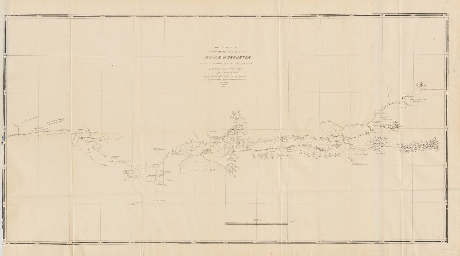
The following map, part of this report, entitled
"Rough Sketch of the Route Followed by Major Warburton"
is shown below
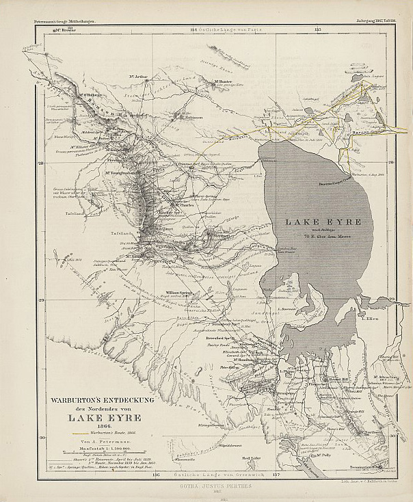
In addition, the map below is provided for a more general overview.
It is sourced from National Library of Australia.
This map is available at http://nla.gov.au/nla.map-rm4174-v
This site is full of FREE ebooks - Project Gutenberg Australia