a treasure-trove of literature
treasure found hidden with no evidence of ownership
(and our other authors) or get HELP Reading, Downloading and Converting files)
or
SEARCH the entire site with Google Site Search
|
Project Gutenberg
Australia a treasure-trove of literature treasure found hidden with no evidence of ownership |
BROWSE the site for other works by this author (and our other authors) or get HELP Reading, Downloading and Converting files) or SEARCH the entire site with Google Site Search |
Title: Early Tasmania
Author: James Backhouse Walker
* A Project Gutenberg Australia eBook *
eBook No.: 1300961h.html
Language: English
Date first posted: March 2013
Date most recently March 2013

Produced by: Ned Overton

Project Gutenberg Australia eBooks are created from printed editions
which are in the public domain in Australia, unless a copyright notice
is included. We do NOT keep any eBooks in compliance with a particular
paper edition.

Copyright laws are changing all over the world. Be sure to check the
copyright laws for your country before downloading or redistributing this
file.

This eBook is made available at no cost and with almost no restrictions
whatsoever. You may copy it, give it away or re-use it under the terms
of the Project Gutenberg Australia Licence which may be viewed online.
GO TO Project Gutenberg Australia HOME PAGE
Production Notes:
The various typographical schemes used in "Early Tasmania" are not consistent from paper to paper; each separate scheme has been retained here.
In this electronic format, the marginal references have been omitted, but a few marginal dates retained [ in ] to assist readers. Each footnote has been placed at the end of the relevant paragraph. The order of Papers 5 and 6 has been reversed so as to group similar topics. In the lists of Aboriginal words, the symbol for "y breve" has been rendered "ŷ". The CONTENTS table has been expanded one level, and the CHARTS labelled below them. Various spellings of names, e.g. "Heemskirk", "Zeehan", etc., stand. A few obvious typographical errors have been corrected.
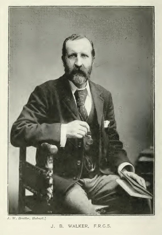
MEMBER OF THE COUNCIL OF THE ROYAL
SOCIETY OF TASMANIA, AND
VICE-CHANCELLOR OF THE TASMANIAN UNIVERSITY.
Tasmania;
JOHN VAIL, GOVERNMENT PRINTER.
—
1902.
(Born 14th Oct., 1841; died 4th Nov., 1899,)
IT is the privilege of the writer to have known the late and much lamented Mr. James Backhouse Walker, F.R.G.S., through all his life, and he has been asked to supply a short memorial preface to the following papers which were read before the Royal Society of Tasmania.
Mr. Walker was born at Hobart in the year 1841. His father, Mr. George Washington Walker, was a well-known and much respected member of the Society of Friends, and transmitted his simple and altruistic ways to his children. In the early years of these Colonies he was deputed, with Mr. Backhouse, by the Society of Friends, to visit the Australian settlements, and to inquire into and report upon their social condition. They did so at much cost of time and labour, and their representations were not without effect on the Colonial Office in Downing-street, which, in the old times, was the most perfunctory of State Institutions, very ignorant, very indifferent, and very contemptuous of communities which they regarded as almost wholly made up of the scum of the Empire. When his mission was fulfilled, Mr. Walker, the elder, came back to Tasmania, took his place as a leader in philanthropic work, and became Manager of the Savings Bank in Hobart, and occupied the position to the time of his death. At an early age the son, James, was sent to school in England, and when he came back to his home was a pupil of the late Rector of the High School, the Rev. E. D. Poulett-Harris. As a scholar, he was steady, bright, and intelligent, and much regarded by his fellows for his simple and genial ways. Even then he was prone to wander in the paths of literature, and cared more for Homer than Euclid. In due time he passed the A.A. Examination of the Council of Education, and when he left school he was put on the staff of the Savings Bank, under the charge of his father. No doubt the discipline of his work as an accountant was of great service to him through all his subsequent career, but it was very irksome, and made no appeal to his ambition. He determined to give it up, and to qualify himself for the legal profession, though it might involve the patience of years. Through all his routine work he drank deeply from the wells of general literature, and passionately studied many of the masters of immortal memory. He knew, though he never made a parade of his knowledge. In the practise of his profession he took a high stand, and won the confidence and esteem of his brethren for his sound judgment, integrity, and honour, and they have shown their appreciation of his work by contributing to the foundation of a scholarship in his memory in the University of Tasmania.
Mr. Walker, as might be expected from his bringing up, was very sympathetic with all movements for the uplifting of our social and moral condition, though sufficiently alive to the futility of many well-meant but ill-considered schemes of doing good. He had a singular power of winning the affection and confidence of young people, who believed in his judgment, and trusted in his good will. He took boys one by one with a due consideration for their personal equation, and many a Tasmanian lad owes much of his success in life to the wise and sympathetic counsels of their friend. Little children gathered round him as they did about Lewis Carroll, and clung to him with perfect trust and joy. He was, at any rate, very lovable to them all.
Mr. Walker was a broad-minded man, and he took an intelligent and sympathetic interest in scientific research of every kind, though he never claimed to be an expert in many questions discussed at the meetings of the Royal Society. The special bent of his mind was towards literature and history. The story of our earliest Australian days was to him a theme deserving the most careful study, and that ought to be rightly told and thoroughly sifted. To know about Tasman and the first discoverers he thought worth painstaking labour; and to correct the legends that have gathered round the fact as it was, seemed to him almost a religious duty. He would take nothing at second hand if he could help it, but went back to the original sources, even to ransacking the archives of Holland for anything that would throw light on Tasman and his career. And so it was all through, and his papers show how hard he worked to secure accuracy where accuracy was possible.
Next, if next, to Mr. Walker's interest in the Royal Society, was his interest in the cause of higher education, though, indeed, it was as a branch of higher education that he set so much value on the work of scientific research, which the Royal Society was designed to promote. He had much to do with starting the University of Tasmania, and guiding and supporting it through the difficulties of its earliest years. He was, perhaps, the hardest worker in the Council, and certainly he was second to no one in wise and loyal service to the Institution. His colleagues in the University know best the loss that they have suffered by Mr. Walker's passing from among us.
In conclusion, there are sacred things on which one can hardly touch in a paper like this, but, perhaps, in the circumstances, I may be allowed to say that my dear friend seemed to me to be a man who tried to pitch his life to the old Hebrew oracle, "He hath shewed thee, O man, what is good; and what doth the Lord require of thee, but to do justly, and to love mercy, and to walk humbly with thy God."
GEORGE CLARKE.
BY JAMES BACKHOUSE WALKER.
(Read November, 1888.)
As the subject of the present Paper may appear to be scarcely within the scope of the objects of the Royal Society, it seems, proper to state briefly the occasion of its being written and submitted to the consideration of the Fellows.
Some two years ago, the Tasmanian Government—of which the Hon. James Wilson Agnew, Honorary Secretary of the Royal Society, was Premier—following the good example set by the Governments of New South Wales, Victoria, South Australia, Queensland, and New Zealand, directed search to be made in the English State Record Office for papers relating to the settlement and early history of this Colony. The idea originated in a suggestion from Mr. James Bonwick, F.R.G.S., the well-known writer on the Tasmanian Aborigines, who had been employed for years on similar work for various Colonial Governments, and to him the task was entrusted by Dr. Agnew. Mr. Bonwick searched, not only the Record Office, but the papers of the Admiralty, the Foreign Office, the Privy Council, and the British Museum, and discovered and copied a large mass of documents relating to the early days of Tasmania. In the early part of this year, these copies, extending over some 640 foolscap pages, were received in Hobart, and the present Premier—the Hon. Philip Oakley Fysh—obligingly allowed me to peruse them. I found them to be of great interest. They threw quite a new light on the causes which led to the first occupation of this Island; gave a complete history of Bowen's first settlement at Risdon Cove; and supplied materials for other hitherto unwritten chapters of Tasmanian history. Upon informing Mr. Fysh of the result of my examination, he entered warmly into my proposal to put before the public in a narrative form the information acquired, and placed the documents at my disposal for that purpose. It is at Mr. Fysh's suggestion that this first paper on the subject is now submitted to the Royal Society. The introductory sketch of the operations of the French in Tasmania has been compiled from the original published narratives of the expeditions. Some history of preceding events seemed necessary for a proper understanding of the transactions referred to in the documents under notice. My object has been, not to give a history of the discovery and early exploration of our Island, but merely such an outline of the rivalries of the French and English in these seas as would suffice for a better apprehension of the motives which prompted the first occupation of the Derwent.
The story of the first settlement of Tasmania, and of Lieutenant Bowen's little colony at Risdon Cove, has never yet been told, so far as I can discover. West, Fenton, and other authors give meagre, inaccurate, and contradictory particulars. No writer records even the date of Bowen's landing. Mr. Bonwick's researches now, for the first time, enable us to give this missing first chapter of Tasmanian history.
The Cambridge Professor of Modern History, in a recent remarkable book, has shown that the great English event of the 18th century, indeed, the greatest fact of modern English History, has been the expansion of England into lands beyond the seas—the foundation and growth of a Greater Britain. Professor Seeley holds that the great hundred years' struggle between England and France, lasting from the time of Louis XIV. to the days of Napoleon, was, in the main, a duel between the two nations for the possession of the New World. Even in the English conquest of India the Professor traces, not so much the ambition of conquest and the lust of empire, as fear of the French and rivalry with them. By the close of the last century the issue of the strife was no longer doubtful. In India, Wellesley had annihilated French influence, and was rapidly consolidating the English dominion. France had lost for ever her finest possessions in America, though she, on her side, had dealt us a return blow in assisting to tear from England her North American Colonies.
But the struggle was not over, and it was destined to yield yet wider triumphs for the English race. The very humiliation which, France had helped to inflict on her rival was to prove a potent factor in the further expansion of "Greater Britain". It is probably no exaggeration to say that it is to the hostility of France, and her action in America, that we owe in no small measure the British colonisation of Australia—a work which must ever stand as the most momentous event of our century.
The secession of her North American provinces had well nigh left England without a colonial empire. Englishmen straightway set themselves to search for a compensation for their lost possessions, and to And a new outlet for their energies and for their surplus population. A new world lay ready to their hand. As David Livingstone, in our own days, has called into existence a new realm in the dark continent of Africa, so in the days of our great grandfathers, the genius of Captain Cook, England's greatest circumnavigator, had opened up a new realm in the unknown and mysterious seas of the South. But in these Southern seas, as formerly in America and India, England and France were, and indeed still are, rivals. In exploration each nation can boast of distinguished names. The English navigators, Anson, Vancouver, Cook, Furneaux, and Flinders, had active competitors in the Frenchmen, Bougainville, Marion, Surville, La Pérouse, D'Entrecasteaux, and Baudin. Nor were the English the first to entertain the design of colonising the new lands. So far back as the year 1756, an eminent and learned French advocate, M. le President Charles de Brosses, in his Histoire des Navigations aux Terres Australes, had strongly urged upon the Government of France the wisdom of establishing a French colony in the South seas. In the work cited the author passes in review the relative advantages of various portions of the Southern world, and concludes that some part of Australasia * offers the best prospects for settlement, the country being favourable, and access easy, with Pondicherry as a base of operations.** He rejects New Zealand and Van Diemen's Land as too remote; and after hesitating for a while over Quiros' Terre du St. Esprit (the coast between Cooktown and Townsville), finally inclines to New Britain as the most suitable locality. With a sagacious foresight, since amply justified by events, he declares that any colony planted in these regions would hold Ariadne's clew for the whole Southern world. From such a centre, every part of this new realm could in time be explored and conquered, from the Equator to the Antarctic Circle. He elaborately discusses the best means of forming such a settlement, and recommends that after its first establishment a certain number of convicts, male and female, should be sent to it every year to supply the necessary labour, and to be in time transformed from a danger and burden to the State into industrious and useful citizens.*** Still further to strengthen the new colony, he would deport to it, as free citizens, numbers of foundlings, who are in a sense the property of the State which has reared them, and can therefore dispose of them at its pleasure. He warns his countrymen against the danger of waiting until some other nation had proved the practicability of a colony by trying the experiment; for when once any nation has gained a foothold it will not suffer another to share the territory to which it has thus acquired a right by conquest.**** Although various discovery expeditions were despatched from France to the South Seas after the days of De Brosses, the President's warning remained unheeded. France missed her opportunity, and it was left to England to take the first step, and found a new empire in these southern seas, from which—justifying the Frenchman's forecast—she did not scruple from the very first peremptorily to warn off all intruders.
[* De Brosses was President of the Parliament of Dijon. To him we owe the invention of the name Australasia. Nav. aux Terres Aus., i., 80.]
[** Nav. aux Terres Aust., ii., 367, et seq.]
[*** Ibid., i., 28, et seq.]
[**** Ibid., ii., 408.]
It was probably due to the fact of the coincidence of Captain Cook's discoveries with the loss of the American colonies, quite as much as to her naval supremacy, that England chanced to be beforehand with her rival. It takes an effort of imagination to realise the New World which Cook revealed, and how he opened up to men's minds the possibilities and promise of the new field for enterprise. Until his time, New Holland—for as yet Australia was not *—had been little more than a geographical expression. Parts of the Northern and Western coasts, and one ominous Bay of Storms at the South, were laid down more or less vaguely on the maps from the reports of Dutch navigators of the preceding century, and those old and infrequent voyagers had brought back only reports of forbidding shores and desolate territory. The right to these dreary coasts was conceded without dispute to the Dutch, for it was a land that no man desired. The English had no part in its discovery. One Englishman, indeed, and one only—William Dampier—had touched on the Western coast in the year 1688, had found a barren sandy soil, inhabited by wretched savages, with no redeeming advantage, and had left it gladly, thinking it the most miserable spot on the face of the earth. Such was the state of affairs when Cook appeared on the scene. In 1770, on his return from the observation of the Transit of Venus at Tahiti, and in pursuance of instructions to try to solve the mystery of the great South Land, the Endeavour, after rediscovering and surveying the islands of New Zealand, sailed west till the eastern shore of New Holland was sighted. Cook explored the coast from Cape Howe to Cape York; landed at Botany Bay, hoisted the English flag, took possession of the country in the name of King George, and returned home to report the existence of a fine and fertile territory in a temperate climate, well suited for English settlers. At home the growth of feeling in favour of a milder penal code had rendered it necessary to devise some scheme for disposing of criminals, and Pitt and the English Government resolved to choose Botany Bay as the field for a project which should relieve English difficulties, and lay the foundation of a new colony. The first fleet sailed from England, and in January, 1788, Governor Phillip planted the first settlement in New Holland, substantially on the lines indicated in detail by the French President more than a quarter of a century before.
[* Quiros (1606) named his discovery Australia del Espiritu Santo, in honour of Philip of Austria. Purchas, in his English translation of Quiros' voyage (1625) called it Australia Incognita—(See Petherick's Bibliography of Australasia). Dalrymple, in his Collection of Voyages (1770) suggests the name, and Flinders revived it in the Introduction to his Voyage to Terra Australis, 1814, p. iii.]
But the French had never ceased to turn longing eyes towards the new Southern world. If the mind of France had not been so fully occupied in the desperate effort to maintain her naval power against the English in other seas, it is quite possible that to her, and not to England, would have fallen the dominion of Australia. And, probably, suspicion of French designs had its effect in hastening English action. Already, in 1785, the French Government had despatched the celebrated La Pérouse with an expedition to circumnavigate the world, and explore the coasts of New Holland, doubtless, with some more or less definite design of settlement. When, on the 26th January, 1788, La Pérouse, with his ships, the Boussole and the Astrolabe, sailed into Botany Bay, he found an English fleet at anchor there, having arrived five days before him. Governor Phillip had just left the Bay in the Supply to find in Port Jackson a more suitable site for a town; and on the very day La Pérouse's ships came to an anchor the city of Sydney was founded. The French remained in Botany Bay for six weeks, the English and they maintaining a friendly and pleasant intercourse. Collins says that the French were very unfavourably impressed with the prospects of the settlement, the officers having been heard to declare that in their whole voyage they had never found so poor a country, or such wretched people as the natives of New South Wales. On the 10th March La Pérouse sailed from New South Wales to vanish into space—the mystery which shrouded his fate not being solved until nearly 40 years had elapsed.
The English foothold on the Australian continent was now securely established, and disregarding the western half, to with the Dutch were still considered as having a title—something like their present title to Western New Guinea—England, by solemn proclamation, formally laid claim to the whole eastern territory from Cape York to the extreme South Cape of Van Diemen's Land, and as far west as the 135th degree of east longitude.
Still France did not relinquish her dreams of colonisation, but seemed to cherish the idea of disputing with her great rival her exclusive possession of the new territories. There is reason to think that the French designs, if ever distinctly formulated, pointed to the southern extremity of Van Diemen's Land as the locality for a settlement. The Terre de Diémen and the Baie des Tempêtes exercised a particular fascination over successive French navigators, and excited the attention of the French Government. It was a spot known only for a forbidding rock-bound coast, washed by an angry sea, and lashed by perpetual tempests. For more than a century after its discovery by Abel Tasman in 1642 no European had invaded its solitudes, until on the 4th March, 1772, the French navigator, Marion du Fresne, anchored his ships, the Mascarin and the Castries, in the Frederic Hendric Bay of Tasman.** He remained there six days, landed, and attempted to establish intercourse with the natives, the attempt resulting in an encounter in which the first Tasmanian aborigine fell under the fire of European muskets. After Marion, the English, navigators Furneaux (1773) Cook (1777), Cox (1789), and Bligh (1788 and 1792) paid passing visits to Adventure Bay; but it was a Frenchman, again, who made the first survey of the approaches to the Derwent. The instructions to La Pérouse in 1785 had directed him to explore this, the extreme southern point of New Holland; and the last letter written by him from Botany Bay, on 7 February, 1788, notes his intention to proceed there before his return,—an intention there is some reason to believe he executed.*** The exploration was made four years later by Admiral Bruny D'Entrecasteaux, Commander of the expedition sent out by the National Assembly in 1791 to search for the missing navigator. It was to Storm Bay that his ships, the Recherche and Esperance, first directed their course from the Cape of Good Hope. The autumn of 1792 was far advanced before the French Admiral sighted the basaltic cliffs of Van Diemen's Land. Through an error of his pilot, Raoul, he missed Adventure Bay, which he had intended to make, and on 21st April cast anchor at the entrance of the inlet afterwards known to the English as Storm Bay Passage, but which now more fittingly bears the name of D'Entrecasteaux Channel, after its discoverer. Recherche Bay, close at hand, offered a safe and commodious harbour for the ships; and here they remained for a month, their boats exploring and surveying the channel and the various inlets on the coast, while the scientific men journeyed inland, made observations, collected specimens of natural history, and revelled in the examination of a new flora and fauna. The natives, at first timid and distrustful, were soon conciliated, and showed themselves most friendly to the Europeans. On the 17th May the ships entered the Channel, and the French viewed with astonishment the extent of the harbours which unfolded themselves to their delighted gaze, affording a secure shelter spacious enough to contain easily the combined fleet of all the maritime powers of Europe. After a fortnight employed in examining the Channel, the Admiral sailed out of the Passage into Storm Bay, rounded the Pillar, and proceeded to New Caledonia. In the summer of the following year he returned to Van Diemen's Land, and spent another five weeks in the Channel (21 January to 28 February, 1793). During the second stay the French completed the surveys which they had begun in the preceding autumn, explored Norfolk Bay and Frederick Henry Bay (Baie du Nord), and ascended 20 miles up the Derwent, which they named Rivière du Nord. Flinders, with his usual generous recognition of the work of previous navigators, says of the charts of Beautems Beaupré, the hydrographer of the expedition, that "they contain some of the finest specimens of marine surveying perhaps ever made in a new country." Labillardière, the naturalist and historian of the expedition, devotes more than 160 pages of his work to a description of the Terre de Diemen. He speaks with enthusiasm of the country and its productions, of its magnificent forests of blue-gum and other timber, of its soil and fertility, and of the amiability of its peaceful inhabitants, and dilates with pardonable pride and satisfaction on the grandeur and extent of the harbours which French enterprise had discovered in this hitherto dreaded coast. The lengthened stay of D'Entrecasteaux, the minute and elaborate nature of his surveys, and the space his historian devotes to a description of the country and its advantages, indicate some further object than mere geographical research. The names which stud our southern coast, and are familiar in our mouths as household words,—Bruny Island, D'Entrecasteaux Channel, Recherche Bay, Port Esperance, River Huon, Cape Raoul, and others,—stand a perpetual monument to the memory of the French navigators.
[** This it not the Frederick Henry Bay of the colonists, but that marked on the maps as Marion Bay, on the East Coast.]
[*** Bent's Almanac for 1827 states that in the year 1809 Captain Bunker, of the ship Venus, found, buried on the shore of Adventure Bay, a bottle containing letters from La Pérouse dated one month after his leaving Port Jackson. In the year 1826 Captain Peter Dillon discovered traces of La Pérouse's expedition at Vanikoro, in the Santa Cruz Group.]
And now, at length, English explorers appear upon the scene. In 1794, Lieut. John Hayes, of the India Navy, was despatched from India in the ships Duke of Clarence and Duchess on a voyage of discovery, including the exploration of the coasts of Van Diemen's Land. He sailed up the Rivière du Nord—which he re-christened the Derwent—as far as Herdsman's Cove. As the admirable charts of D'Entrecasteaux were unknown to the English until long years after, it was on Hayes' sketch that subsequent visitors had to rely, and in many cases the names he gave have been substituted for those given by the French.
In December, 1797, the adventurous Bass, leaving Port Jackson in an open whaleboat, had solved the vexed problem of the strait which bears the name and immortalises the intrepid daring of its discoverer; and late in the year 1798, Bass and Flinders, in the Norfolk, a little sloop of 25 tons, sailed through Bass' Strait, explored Port Dalrymple, circumnavigated Tasmania, and made a careful examination and survey of the Derwent and its approaches and neighbourhood.
On the 19th October, 1800, when Bonaparte was first Consul, an expedition, consisting of two ships, the Géographe and Naturaliste, sailed out of Havre, amidst great demonstrations, for a voyage of discovery round the world. Commodore Baudin, in the Géographe, was chief of the expedition; Captain Hamelin commanded the Naturaliste. Although fierce war was raging at the time between the two nations, the English Admiralty granted a passport or safe conduct to Baudin, on the ground that scientific expeditions should be exempt from hostilities. Notwithstanding these courtesies of the English Government to the French commander, it was shrewdly suspected that the real design of the expedition was to spy out the state of the English possessions in New Holland, and, if practicable, hoist the standard of Bonaparte at some convenient point of the coast and establish a French colony. Certain it is that Baudin's instructions—afterwards published in Péron's account of the voyage—give colour to the belief. They direct the captain to proceed direct from the Mauritius to the southern point of the Terre Diemen, double the South Cape, carefully examine the Canal D'Entrecasteaux in every part, ascend all the rivers in this portion of the island as far as they were navigable, explore all the eastern coast, carefully survey Banks' Straits, sail through Bass' Strait, and after exploring Hunter's Islands, proceed to the continent of New Holland and search for the great strait which was supposed to separate the eastern part occupied by the English, from the western portion claimed by the Dutch. All this certainly looks very like some further object than geographical discovery. The French expedition doubtless stirred the English to renewed activity, and through the influence of Sir Joseph Banks, Earl Spencer (then at the head of the Admiralty) consented, early in 1801, to despatch the Investigator, a sloop of 334 tons, to make a complete survey of the coast of New Holland. The command was given to Lieut. Matthew Flinders, who had already distinguished himself by some daring explorations in company with Dr. George Bass: and amply did he justify his appointment. The ship's complement was 88 persons, amongst whom served, as a midshipman, John Franklin, afterwards destined, as Sir John Franklin, to become Governor of Tasmania, and to die in solving the problem of the North-West Passage. The Investigator sailed from Spithead on the 18th July, 1801, and sighted Cape Leeuwin on 6th December following. Meantime Commodore Baudin, deviating from his instructions, had gone to the western coast of Australia, and it was not until the 13th January, 1802, that he sighted the De Witts Islands (known to our fishermen as "The Witches"), off the south coast of this island. The French commander anchored next day off Partridge Island, in the Channel; remained there until the 17th February—36 days; occupied the warm summer season in making a very complete examination and survey of the Channel, the River Huon and Port Cygnet, Frederick Henry and Norfolk Bays, and exploring the Derwent carefully nearly as far as Bridgewater. The French had many interviews with the natives, doing everything in their power to conciliate them, and with complete success. Péron, the naturalist, who wrote the history of the expedition, devotes nearly 100 pages of his first volume to Van Diemen's Land. He gives a glowing description of the beauty and capabilities of the country, and a poetical and highly-coloured picture of the kindliness and good qualities of the aborigines. On leaving Storm Bay the Frenchmen sailed for the east coast; they examined Maria Island, visited the Schoutens and Freycinet's Peninsula, and surveyed the remainder of the coast until they reached Banks' Strait. Here the ships were separated by a storm. The Naturaliste surveyed Banks' Strait, and explored the Hunter Islands and other islands in Bass' Strait; and the Géographe sailed for the south coast of New Holland—or, as Baudin christened it, Napoleon Land—to search for the channel which was supposed to divide New Holland. The French expedition had surveyed the whole coast-line of Van Diemen's Land, with the exception of the west coast from Cape Grim to Port Davey.
On the 8th April, 1802, the ships of Baudin and Flinders met off Kangaroo Island. Flinders states that Baudin was communicative of his discoveries in Van Diemen's Land, and declares that he, on his part, furnished the French commander with every information as to his own explorations of the coast, and gave him directions for his guidance. Péron, in his brief notice of the interview between the two commanders, simply remarks that Flinders showed great reserve on the subject of his own operations. The object of this suppression of facts by the Frenchman will appear later on.
On the 25th April, 1802, Captain Hamelin, in the Naturaliste, arrived off Port Jackson. His provisions were exhausted, his crew prostrated by scurvy. He was in urgent need of succour. Yet he approached Port Jackson with many misgivings. War, so far as he knew, was raging in all its bitterness and fury between France and England, and though he bore a safe conduct from the Admiralty, he fully anticipated that he would not be allowed to enter the Port, or, if he was, that the aid he so much needed would be refused him. But his doubts were soon dispelled, for, as he says, he was instantly welcomed by the English with magnanimous generosity. Not only were all the resources of the country placed at the disposal of the French captain, but the most distinguished houses of the colony were thrown open to his officers, and during the whole time they remained they "experienced that delicate and affectionate hospitality which is equally honourable to those who confer it and to those who are its objects." The news of the Peace of Amiens (proclaimed 27 March, 1802), which reached Sydney a short time later, though it made intercourse more pleasant, "could not", Péron says, "increase the kindness which the English displayed towards us." A fortnight later (May 9) Flinders, who had completed a thorough survey of the South Coast, arrived at Port Jackson in the Investigator.
Baudin, in the Géographe, had been some six weeks on the South coast of New Holland, rediscovering and renaming the discoveries already made by Flinders. His crew were suffering terribly from scurvy, and his officers urged his going to Port Jackson to recruit. Whether the Commodore doubted the nature of his reception, or whether the attractions of the Terre de Diemen proved irresistible, does not appear, but Baudin disregarded their protests, and to their intense chagrin, though winter was fast approaching, headed his ship for the cold and stormy south, and on 20th May once more cast anchor in Adventure Bay. The state of his ship's company, however, was such that after only two days' stay he was obliged to give orders to sail for Sydney. Baffled by contrary winds, battered by violent storms, with a crew unable, from illness, to handle the ship, it took him a whole month to make the passage. On the 20th June the Géographe approached the heads of Port Jackson. Not only were they apprehensive respecting the fate of the Naturaliste, and as to the nature of their own reception, but the condition of the crew was most deplorable. Flinders says "it was grievous to see the miserable condition to which both officers and crew were reduced by scurvy, there being, according to the commander's account, out of 170 men not more than 12 capable of doing their duty." Péron quotes the Commander's journal as stating that but four of the crew, including a midshipman, were able to keep the deck, and he adds "there was not one on board who was free from the disease." Many had died, and the surgeon, M. Taillefer, gives a horrible description of the sufferings of the survivors.* In fact, on arriving off Port Jackson the Géographe was unable to make the harbour, until Governor King had sent the Investigator's boat with a number of hands to work the vessels into port. It is hardly necessary to say that the distressed Frenchmen were received with the greatest kindness. The numerous sick were removed to the Colonial Hospital, and tenderly cared for by the English surgeons. Whatever they had need of that the place could furnish was placed at their disposal, and the Governor gave the Commander an unlimited credit at the Public Treasury to enable him to revictual and refit, and also purchase a third vessel. More than this: the Colony was at the time in great want of fresh provisions, floods on the Hawkesbury having destroyed the wheat harvest, salt meat was exceedingly scarce, and fresh meat almost unprocurable; yet so soon as the strangers' necessities were known, Government oxen were killed, and by a common consent the ration of wheat issued to garrison and inhabitants, including the Governor and officers, was reduced one-half, so that the scurvy-stricken crew might not want what was so essential for their recovery. This statement is made on the authority of a letter written by Baudin himself. Both he and Péron handsomely acknowledge the kindness they received, and exhaust their phrases in describing the affectionate and obliging care of Governor King and his unexampled conduct, the courtesy and unremitting attention of the inhabitants, the generosity of the Government, the absolute freedom accorded to their movements, and the sentiments of gratitude which these kindnesses inspired.
[* The scurvy was at this period the scourge of the naval and mercantile marine, and especially of discovery expeditions. Vancouver attributes the high position England had attained, in a great degree, to the attention her captains paid to naval hygiene. The French discovery crews always suffered terribly from want of proper precautions, and from Péron's account Baudin's ships were miserably victualled, and their commander culpably indifferent to the health of his men. Out of 23 scientific men who left France in the Géographe and Naturaliste only three returned to their country. Out of 219 men who sailed with D'Entrecasteaux, 89 died before the ships returned to Mauritius. The French voyages of discovery were singularly fatal to their commanders. Besides La Pérouse, who perished with all his ship's company, not one of the commanders who visited Tasmania lived to return to his native country. Marion du Fresne was killed at New Zealand. Admiral D'Entrecasteaux died at sea off the Admiralty Isles, and his second in command, Huon Kermadec, at New Caledonia. Baudin himself died at Mauritius on the voyage home.]
I have dwelt particularly on these incidents, not only because it is matter of pardonable pride to record how chivalrously Englishmen can behave towards an enemy in distress, but because of the striking contrast which the aid and courtesies extended to the Frenchmen by Governor King and the English colonists offer to the treatment Flinders experienced from the Governor of a French Colony within little more than a year of the arrival of Baudin's expedition at Sydney. In December, 1803, on his way to England in the little Cumberland, Flinders was obliged to put into Mauritius in distress; when, in spite of his safe conduct from the French Admiralty, his ship was seized as a prize, he himself subjected to close imprisonment, his papers and charts confiscated, and when, after three years, tardy orders for his release came from France, he was detained on one pretext or another until 1810, six years and a half after his seizure. In the meantime the narrative of Baudin's voyage was published in Paris, all mention of Flinders' explorations being suppressed, and the credit of his discoveries being claimed by the French for themselves. In Sydney, at any rate, the French officers had made no pretensions to priority of discovery, for Flinders tells us that Lieut. Freycinet (the joint editor of the history of the voyage), remarked to him, in Governor King's house—"Captain, if we had not been kept so long picking up shells and collecting butterflies at Van Diemen's Land, you would not have discovered the South Coast [of New Holland] before us;" and Flinders, in Péron's presence, showed his chart to Baudin and pointed out the limits of his discovery. Flinders generously acquits Péron of blame in the matter, and says that he believes his candour to have been equal to his acknowledged abilities, and that what he wrote was from overruling authority, and smote him to the heart. He attributes the suppressions in Péron's work, and his own treatment, to the secret instructions of the French Government, and possibly to have "been intended as the forerunner of a claim to the possession of the countries so said to have been first discovered by French navigators."
The foregoing sketch of the operations of the French navigators in these waters will, I think, have made ii pretty plain that the French Government entertained serious designs of planting a colony at the first convenient opportunity somewhere in Tasmania, presumably in the neighbourhood of the Derwent. How disastrous to the English colonies in Australia the successful accomplishment of such a design would have been we can partly appreciate from our recent experience of the trouble and vexation caused to the Australians by the existence of a French penal settlement even so far removed from our shores as New Caledonia.
The following particulars of the circumstances which were the immediate occasion of the English occupation of Van Diemen's Land are drawn almost wholly from unpublished documents preserved in the English State Record Office, and which I have already referred to as having been lately copied by Mr. Bonwick for the Tasmanian Government. They will show that the colonisation of Tasmania was not an isolated or chance event, but one link of a chain,—a ripple in the great current of influence which has been shaping English and European history.
On the 18th November, 1802, after a six months' stay, the two French ships sailed out of. Port Jackson for Bass' Straits. The Naturaliste was intended to take home the sick, leaving the Géographe to complete her voyage of discovery alone. Governor King had not been without misgivings respecting the movements of the French, and had given expression to them in a despatch to Lord Hobart written a few days before; but his suspicions only proceeded from the circumstance of the long time they were engaged in surveying at Storm Bay Passage. Moreover, the recent discovery of Bass' Straits, by proving Van Diemen's Land to be an island, had given rise to a new cause for apprehension, since it might now be fairly contended that the island could not form part of the territory of New South Wales, and that the English, having no prior right of discovery, could not make good their claim, while the French expeditions, by their explorations and surveys, had established a superior title. But a few hours after the French ships were out of sight, a piece of gossip reached the Governor's ears which fairly startled him out of his equanimity. This was a report that some of the French officers had stated, in conversation with Lieut.-Colonel Paterson and others, possibly in a convivial moment, that a principal object of their voyage was to fix on a place at Van Diemen's Land for a settlement. The alarmed Governor sent off forthwith to Colonel Paterson for more precise information, and the answer he received, on that same Tuesday morning on which the ships had sailed, more than confirmed his worst fears. Not only had the talk among the French officers been so general that the Colonel could not understand how it was that the Governor had not heard of it, but one of the officers had sent Paterson a chart, and had pointed out the very spot selected—the place where they and D'Entrecasteaux also had spent so much time—the Baie du Nord [now known as Frederick Henry Bay], in Storm Bay Passage, or, as the French called it, Le Canal D'Entrecasteaux. King, of course, knew very well that Baudin could, at most, take formal possession, for, with his small and sickly crew, and without stores or provisions, he had not the means to found a colony. There was no immediate danger on that score, but he did not know what recommendations might have been sent to the French Government, or how soon a properly equipped expedition might be on its way from France to plant a settlement, and, being a man of action, accustomed to act promptly and on his own responsibility, without waiting for instructions that might be twelve months in reaching him, he proceeded forthwith to take steps to prevent an invasion of His Majesty's territory of New South Wales, of which territory he was the guardian. His first difficulty was to find a ship. The naval strength at the command of the Governor of New South Wales was not large. His Majesty's ships in these seas were few in number, small, and often unseaworthy, and there was a constant difficulty in finding vessels that could be spared for any special service. Of those under his orders the Buffalo was essential at Port Jackson, the Lady Nelson was off north with Flinders, the Porpoise, the only other king's ship, was away at Tahiti salting pork for the necessities of the colony. But there was in Port Jackson a little armed schooner called the Cumberland, which had been built at Sydney a few years before for the purpose of pursuing runaways. She was only 29 tons burden, it is true, but she would do to checkmate French designs. This little craft was therefore hastily prepared for sea, a crew was selected, Lieut. Chas. Robbins, master's mate of H.M.S. Buffalo, was put in command, and in four days she was ready to sail. Robbins received several sets of instructions, indicating the uncertainty into which the Governor was thrown. His general instructions required him to proceed without loss of time to Storm Bay Passage,—"the dominion of which, and all Van Diemen's Land, being", says King, "within the limits of His Majesty's territory and my government,"—and to fix on the most eligible places in Frederick Henry Bay and the River Derwent, agreeable to the separate instructions on that head. If, however, Robbins met with southerly or westerly winds, he was to go to King's Island and Port Phillip, for the examination and survey of which places he had separate instructions, and afterwards proceed to Storm Bay Passage. He was to hoist the English flag whenever on shore, placing a guard at each place, who were to turn up the ground and sow seeds. As the Porpoise was intended to follow with soldiers and settlers immediately on her return from Tahiti, he was to keep the King's colours flying to indicate the intended settlement. Captain Robbins was also charged with a letter from King to the French commander, if he should happen to overtake him in Bass' Straits; and he received very precise instructions respecting the action he was to take to assert English rights if the French ventured to infringe them. Having his preparations made, and his little vessel ready for sea, King sat down to report to Lord Hobart the position of affairs. He tells the Secretary for War * that, on hearing Colonel Peterson's report, he had lost no time in expediting the Cumberland, armed colonial schooner; that she was on the point of sailing, and that, from the arrangements he had made, His Majesty's claim to the threatened part of this territory could not be disputed; for, whatever might be in contemplation, it could not be performed by Baudin in his present condition; it was only necessary to guard against any action of the French Government which Baudin might have recommended. It was his intention, therefore, when the Porpoise arrived from Tahiti, to despatch her with a small establishment to the most eligible spot at Storm Bay Passage, and also with one for Port Phillip or King's Island.
[* The Secretary for War was also at that time Minister for the Colonies.]
The Cumberland sailed the same day (23rd November). She had on board Mr. Charles Grimes ** (Acting Surveyor-General), M'Callum (the surgeon), Jas. Flemming (the gardener), and three marines; with the crew, 17 persons. In the journal *** kept by Flemming, the gardener, who was sent to report on the soil and productions of the almost unknown regions to which they were going, we have a chronicle of their proceedings.**** They had a quick run of two days to Cape Howe, but, baffled by contrary winds and calms, were nine days more in reaching Kent's Group, and it was not until the 8th December—a fortnight after leaving Port Jackson—that they made Sea Elephant Bay, on the east coast of King's Island. Here they found the French ships lying at anchor, and at 5 o'clock on that summer evening the little Cumberland dropped anchor alongside them. The Naturaliste was on the point of sailing for France. Captain Robbins boarded the Géographe, announced his mission, and delivered to the Commodore the Governor's letter. It was short, and friendly in tone. King begins by remarking that his intention to send a vessel to the southward, to fix on a place for a settlement, was already known to Baudin himself. He then mentions the report that had led to the departure of this vessel being hastened, and goes on to say that, while wholly disbelieving that the French commander had any thought of such a design as had been imputed to him, yet it seemed but proper that he should be informed of the rumour, and of the orders the captain of the Cumberland had received in consequence. The version of the Governor's letter given by Péron in his history of the expedition represents it as couched in more forcible and less conciliatory terms. Péron says that hardly Lad they anchored at King's Island when the little schooner Cumberland arrived from Port Jackson, bringing Surveyor-General Grimes, who had been sent by Governor King to make a declaration, as singular in its form as it was remarkable in its object. "A report having reached me," wrote Mr. King to our Commander, "that you entertain a design of leaving some people either at Diemen's Land or on the south-west coast of New South Wales, to found a French Colony there, I deem it my duty to declare to you, Monsieur le Commandant, that, by virtue of the proclamation of 1788 whereby England formally took possession, all these countries form an integral part of the British Empire, and that you cannot occupy any part of them without breaking the friendly relations which have been so recently re-established between the two nations. I will not even attempt to conceal from you that such is the nature of my positive instructions on this point that it will be my duty to oppose by every means in my power the execution of the design you are supposed to have in view. Accordingly, H.M.S. Cumberland has received orders not to leave you until the officer in command of her is convinced that your proceedings are wholly unconnected with any attempt at invasion of the British territory in these parts." ***** With King's own copy of his letter before us ****** we can hardly accept Péron's version as accurate. Probably, while professing to give the letter textually, he really relied on his memory, and interwove the substance of the English Captain's verbal communications to the Commodore. It is sufficiently clear, however, that Robbins, with the downrightness of a sailor, had left nothing doubtful or ambiguous with respect to the object of his mission. During the week after the arrival of the Cumberland and the delivery of the despatches, the representatives of the two nations fraternised and interchanged hospitalities on the disputed shores of King's Island. The French, meanwhile, set up an observatory on land, and pitched their tents near the beach. Perhaps it was this proceeding that confirmed Robbins' suspicions, or perhaps the French Commander would not give him the assurances he wanted; at all events, before the end of the week the Englishman made up his mind that the time for decisive action had come; so, on the 14th, he made a formal lading in full view of the Frenchmen, marched his little party to the rear of the tents, hoisted His Majesty's colours on a large tree, posted at the foot of the tree his guard of three marines with loaded muskets, fired three volleys, gave three cheers, and took formal possession of the island in the name of King George. This defiant assertion of British claims by a handful of English sailors, in the teeth of ten times their number of traditional enemies, might well have wounded the vanity of people less susceptible than Frenchmen, and we need not, therefore, wonder that we hear of no more mutual hospitalities. Péron remarks that "such proceedings may probably seem childish to people unacquainted with the English policy, but to the statesman such formalities have a more important and serious aspect. By these repeated public declarations England continually aims at strengthening her claim, and establishing her rights in a positive fashion, and uses these pretexts to repel, even by force of arms, all nations who may desire to form settlements in these lands." * Péron must often have recalled to mind the warning of the President of the Parliament of Dijon half a century before, and reflected with some bitterness how amply the prophecy had been fulfilled.
[** Grimes was one of the first, if not the first, to cross Tasmania from north to south.—See Flinders' Chart, 1807.]
[*** Fleming's Journal was disinterred from the Records in the Colonial Secretary's Office, Sydney, by Mr. J. J. Shillinglaw, in 1877, and was printed in that gentleman's "Historical Records of Port Phillip." Melbourne, 1879.]
[**** Ibid., pp. 15-30.]
[***** Péron's Voyage, 2nd ed., vol. 3, p. 11; and see Appendix B.]
[****** See Appendix B.]
[* The high-handed and exclusive policy of the
English is a frequent topic of complaint in Péron's work.
Thus, he relates that two days after leaving Port Jackson they
fell in with a schooner, on board of which was a M. Coxwell from
the Isle of France, who had accompanied another Frenchman,
Lecorre, on a sealing cruise to Bass' Straits in the
Enterprise, of Bordeaux. He goes on to explain that, while
other nations had been indifferent to the importance of New
Holland, England had, in 1788, despatched a fleet thither and
founded a Colony, and had, without remark from European
statesmen, taken possession of half the Continent. Emboldened by
the silence of other Governments, the British Government had
published the instructions to Governor Phillip claiming the
country from Cape York to the South Cape (lat. 10° to 43°
S.), and as far to the West as the 135th parallel, besides all
the islands in the Pacific, and had established a policy of
exclusion of other nations from the fisheries. So that, on the
arrival of the Enterprise, Governor King, although peace
had been declared, warned Lecorre off the coast under a threat of
seizing his vessel, and, though he finally allowed the Frenchman
to fish at the Two Sisters, it was only on the condition that he
should undertake not to enter Bass' Straits, and that no vessels
in future would be allowed even so much indulgence. Lecorre's
vessel was wrecked at the Two Sisters, and he himself and
two-thirds of his crew perished. Péron says it is plain
that the intentions of the English Government are so hostile that
it will be dangerous for other speculators to venture into these
waters. (Péron's Voyage, 2nd ed., vol. 3, p. 3.)
Governor King, in a despatch to the Admiralty (9th May, 1803),
states his intention of restricting seal fishing by foreigners;
and, in another despatch to Lord Hobart, referring to Lecorre's
vessel, remarks with some satisfaction that the French schooner
had been wrecked at the Cape Barren Islands, "which may stop more
adventurers from that quarter."]
The French Commander's answer to Governor King's letter is worthy of notice, as showing that the French had by no means relinquished their claim to a share of Australian territory. His letter is dated from the Géographe, and bears date the 3rd of the month Nivose, in the 11th year of the French Republic (23rd December, 1802). He tells King that the arrival of the Cumberland, and especially the letter which the Governor had done him the honour to write, would have surprised him if Mr. Robbins had not, by his conduct, made clear to him the true motive of the expedition which had been despatched after him in such headlong haste. "But, perhaps", says the Commodore, "after all, it may have come too late, for several days before the gentleman who commands it thought proper to hoist his flag above our tents, we had taken care to place in four prominent parts of this island—which I intend shall continue to bear your name—proofs sufficient to show the priority of our visit." He then declares that the report-of which they suspected Captain Anthony Fenn Kemp to have been the author, was entirely without foundation, and he does not believe that his officers or scientific men had by their conduct given any ground for it. "But," he concludes, "in any case, you ought to have been perfectly certain that if the French Government had given me orders to establish myself in any place, either at the north or at the south of Diemen's Land—discovered by Abel Tasman—I should have done so without keeping it a secret from you." **
[** See Appendix B for Baudin's letter.]
A week after the date of his letter to King (31st December), Baudin sailed from King's Island for the Gulf of Carpentaria, and from thence made his way to Mauritius, where he died. Surveyor-General Grimes and Flemming spent some six weeks in a thorough exploration of King's Island.*** Their report of the island as a place for settlement was unfavourable. They then proceeded in the Cumberland to Port Phillip, where they remained six weeks, Grimes making an accurate survey of the Port both by sea and land, discovering the River Yarra, and bringing away a more favourable impression of the country, but, as King says, with no very promising hopes that either that place or King's Island would ever be found an eligible place for an agricultural settlement. On leaving Port Phillip, Robbins sailed direct for Port Jackson, where he arrived on 7th March, having been absent about three months and a half. It does not appear why he did not fulfil the rest of his instructions, and go on to Storm Bay Passage. Perhaps, having seen the French ships sail away to the westward, and fairly off the English premises, he conceived the danger to be at an end. King, at any rate, was perfectly satisfied, and writes to the Admiralty that Robbins had conducted the service entrusted to him very much to his satisfaction, and remarks that "making the French Commander acquainted with my intention of settling Van Diemen's Land was all I sought by this voyage."
[*** The island was in those days a favourite resort of sealers. Péron says that when they reached Sea Elephant Bay the beach was covered with sea elephants, their brown colour making them strikingly visible on the white strand, where they lay like great black rocks. At the approach of the French some of the animals plunged into the sea, roaring frightfully, while others remained motionless on the sand gazing on their visitors with a placid and indifferent air. In he same year Captain Campbell, of the Snow Harrington, at New Year's Island, on the western side of King's Island, in 10 weeks (19th March to 27th May) killed 600 sea elephants and 4300 seals.]
The fear that the French might yet make a descent on Van Diemen's Land still weighed on King's mind. As we have seen, before the Cumberland sailed he had determined to send the Porpoise, on her arrival from Tahiti, to make a settlement. The return of Robbins with unfavourable reports of King's Island and Port Phillip had satisfied him that neither of those places was adapted for settlement, and he once more fixed his attention on the point which, now that Baudin had left Bass' Straits, appeared to be most threatened. He, therefore, resolved to limit his action to Storm Bay Passage, and immediately took steps to carry out his resolution.
He reported his intention to the Admiralty, and says in his despatch, "My reasons for making this settlement are the necessity there appears of preventing the French gaining a footing on the east side of these islands; to divide the convicts; to secure another place for obtaining timber with any other natural productions that may be discovered and found useful; the advantages that may be expected by raising grain; and to promote the seal fishery."
There is no doubt that Governor King was in perfect accord with the Home Government in his apprehension of French designs, and in his policy of anticipating them by occupying important points "for political reasons".*
[* See Professor Seeley on Napoleon's intentions in the war that ensued on the rupture of the Peace of Amiens, 18th May, 1803. Exp. of England, p. 34.]
Already, in January of this very year, the Authorities in Downing-street had determined to form a settlement at Port Phillip, and had selected Lieut.-Col. David Collins to be its Lieutenant-Governor, and the date corresponds with the communications that King had made to the English Government with respect to Baudin's expedition.
Five months later (24th June, 1803), in consequence of King's despatch of 23rd November, 1802, informing the Admiralty of the report that the French were about to colonise Van Diemen's Land, Lord Hobart instructed the Governor to remove part of the establishment at Norfolk Island to Port Dalrymple, "the advantageous position of which, upon the southern coast of Van Diemen's Land and near the eastern entrance of Bass Straits, renders it, in a political view, peculiarly necessary that a settlement should be formed there." The amusing confusion of localities does not say much for the state of geographical knowledge at Downing-street, but the anxiety of the Government to anticipate French action is very clearly indicated.
The Governor's mind was now firmly made up to establish a colony at the Derwent, but some months were yet to elapse before he could carry out his plans. One of his difficulties had been to find, out of the slender establishment at Port Jackson, a competent officer to whom he could entrust the command of the intended settlement. The arrival of H.M.S. Glatton at Sydney, in March, 1803, relieved him from this embarrassment. There was on board the Glatton a Lieutenant who had made several voyages to the colony, and so far back as 1792 had been engaged in conveying cattle and provisions from Bengal to New South Wales in the Atlantic storeship, at a time of great scarcity.** He was a son of Commissioner Bowen,*** and we have King's testimony that he came of a family various members of which, including his father, had distinguished themselves in the navy during the French wars. Peace had now been declared, and Lieut. John Bowen saw little prospect of speedy promotion. When, therefore, the Governor spoke of the difficulty he was in through not being able to find a man competent to take charge of the Derwent establishment, it occurred to Bowen that here was a chance for him to earn a claim to notice as the founder of a new colony, and so possibly win a promotion he could hardly hope for as a junior lieutenant in time of peace. He obtained Captain Colnett's permission, and offered his services to the Governor. King was glad to accept them, and on 28th March, 1803, he issued a Commission, in which, after premising that it had become necessary to establish His Majesty's right to Van Diemen's Land, within the limits of the territory of New South Wales, he directed Lieut. John Bowen to proceed in H.M. armed tender Lady Nelson to choose a suitable place for an establishment, and appointed him Commandant and Superintendent of the settlement. The more detailed instructions to the new Commandant, bearing the same date as the commission, direct him to proceed in H.M. armed vessel Porpoise, or Lady Nelson tender, with people and stores for a settlement, and fix on a proper spot in the Derwent, about Risdon's Cove; to begin immediately to clear ground and sow wheat and other crops; and to furnish full reports on the soil, timber, capabilities, and productions of the country. He was to have six months' provisions; was to employ the convicts in labour for the public good; to hold religious services every Sunday; and to enforce a due observance of religion and good order. No trade or intercourse was to be allowed with any ships touching at the port. Arrangements were to be made for laying out a town, building fortifications, and appropriating land for cultivation on the public account. The free settlers who accompanied him, in consideration of their being the first to volunteer, were to have a location of 200 acres for each family, and be allowed rations, the labour of two convicts each for 18 months, and such corn, seeds, and other stock as could be spared. Bowen also received sealed orders with respect to any French ships which might arrive; he was to inform them of His Majesty's right to the whole of Van Diemen's Land, and was to repel any attempt to form a settlement,—if possible, without recourse to hostile measures.
[** So Mr. Bonwick, who gives an extract of a letter from Bowen to the Under-Secretary of State, dated from the storeship Atlantic, March, 1792; Collins, however, gives the name of the Admiralty Agent on board the Atlantic as Richard Bowen. Collins, New South Wales, i., 174.]
[*** Jorgensen's Shred of Autobiography in Ross' Almanac, 1835.]
Another three months elapsed after Bowen had received his Commission before King had vessels at his disposal which he could spare for the service. It was not until the 30th June, 1803, that at last the Porpoise and Lady Nelson sailed from Port Jackson with the Commandant and people and stores for the Derwent. Yet even then the attempt was destined to be thwarted for a time. Both ships were much out of repair and sadly leaky, and on leaving Port Jackson they met with such strong head winds that they were compelled to give up all idea of proceeding on their voyage, and put back to the harbour, arriving on the 4th July. The Porpoise was now required to take Flinders to England, and, after undergoing repairs, she sailed on 10th August, only to be lost a week afterwards, in company with the Cato, on Wreck Reef, to the north of Rockhampton (Lat. 22° 11' S.). King forthwith ordered the Colonial vessel Francis to be fitted out to accompany the Lady Nelson on a second attempt, and wrote to Lord Hobart that he hoped these ships would complete the service, which he deemed the more essential from the inclination the French had shown to keep up a correspondence with Port Jackson.
In those days the exigencies of the service compelled Governors to take whatever offered to aid them in accomplishing their plans. Many were the missions of relief or mail despatch that were entrusted to whalers, or even American sealers, and their remuneration was sometimes odd enough. Thus, on one occasion, Governor King desired Governor Collins to pay for the despatches sent to him by a sealing sloop going to King's Island, by giving the skipper 30 empty salt-meat casks—surely as odd a postage as ever was paid. And it must be admitted that at times the Yankees fleeced the Britishers handsomely for the humane help they afforded—for a consideration.
Let us be thankful that it was not a Yankee sealing schooner that carried the first Governor of Tasmania to the seat of his Government, but a British whaler, which turned up at the right moment—the Albion, 326 tons—whose skipper, Captain Ebor Bunker, was afterwards well known at the Derwent Settlement in early times.*
[* In 1809, when in the ship Venus, he put into Adventure Bay, and there found a bottle containing the last letters of the unfortunate La Pérouse. And his name is yet perpetuated on a tombstone at Crayfish Point, near Hobart, which records that under it lies buried James Batchelor, Second Officer of the ship Venus, commanded by E. Bunker, and that he died 28th January, 1810.]
On the 31st August, 1803, the Albion and Lady Nelson set sail from Port Jackson. The Lady Nelson took the bulk of the people and stores. She was a brig of 60 tons burden, and had been originally sent out in 1800 under the command of Lieutenant Grant to explore the newly-discovered Bass' Straits. A little while before she had been employed as a tender to Flinders' vessel, the Investigator, on the survey of the coast within the Great Barrier Reef. She was commanded by Acting Lieutenant C. G. Curtoys, and had for Chief Officer the redoubtable Dane, Jorgen Jorgensen, the conqueror of Iceland. The same plan of colonisation with convicts and a few free settlers that had obtained in the planting of the settlement at Port Jackson 15 years before, and in settling Norfolk Island in 1788 by King himself, was followed in this little off-shoot from the parent colony. Governor Bowen's Civil Establishment consisted of three persons, including himself. His subordinates were Dr. Jacob Mountgarret, Surgeon of the Glatton, as Medical Officer, and Mr. Wilson as Storekeeper. His military force consisted of one lance-corporal and 7 privates of the New South Wales Corps, There were 21 male and 3 female convicts. Three free settlers accompanied the party—Birt, who took his wife; Clark, a stonemason; and another whose name is not given, who was made overseer of convicts. Three other free persons, a man and two women, also obtained leave to try their fortunes in the new settlement. Thus the whole colony consisted of 49 persons, of whom 13 were women and children. They took about six months' provisions and some live stock—viz., 10 head of cattle and about 50 sheep—while the Governor had the only horse, and the settlers a few goats, pigs, and fowls.
The Albion and Lady Nelson put to sea on the 31st August; but Governor Bowen was invariably unlucky at sea, and on the second day of their voyage they encountered a heavy gale, which obliged the Albion to heave-to, and cost them heavy losses among the live-stock. Then it fell calm, for which, however, Captain Bunker found consolation by catching three sperm whales. The Albion had a reputation for fast sailing—having made the passage from Spithead to Port Jackson in the then unprecedented time of 108 days—but, baffled by light unfavourable winds, she did not make Storm Bay until the tenth day out. Even then she was two days beating up the river against head winds, so that it was not until Sunday, the 12th September, 1803, that, passing along the lonely and thickly wooded banks of the Derwent, the Albion, with the first Governor of Tasmania on board, came to an anchor in Risdon Cove. Here they found the Lady Nelson already lying at anchor, having arrived five days before, on the 7th September.
I have searched in vain hitherto in printed accounts for the correct date of Bowen's settlement. The dates given vary from June to August, but I think we may henceforth consider it settled, on the authority of official documents, that the birthday of Tasmania was Tuesday, the 7th day of September, 1803.
Here I must pause. On a future occasion I hope to be able to draw further on the store of material which has been provided by the wise liberality of the Government, and to give some particulars of the history of Bowen's abortive colony at Risdon, and of Collins' settlement at Sullivan's Cove.
SUMMARY OF DOCUMENTS COPIED BY MR. BONWICK FOR THE TASMANIAN GOVERNMENT.
1. British Museums Discovery Papers,
viz.—Furneaux, in the Adventure, 1773; Grant, in
the Lady Nelson, 1800; Flinders to Sir J. Banks, 1802;
Sealers in Bass' Straits, 1802; Exploration of River Huon,
1804
. . . . . 59 pages.]
2. Despatches relating to supposed French
designs on Australia; especially the proceedings of Baudin's
Expedition, and the measures taken by Governor King to anticipate
the French in forming a Settlement in Van Diemen's Land,
1802-3
. . . . . 25 pages.]
3. The Bowen Papers—First Settlement at
Risdon Cove, 1803
. . . . . 48 pages.]
4. The Collins Papers—Settlement of
Hobart Town, 1804
. . . . . 300 pages.]
5. Exploration of Port Dalrymple and River
Tamar—Settlement at York Town under Colonel Paterson,
1804
. . . . . 124 pages.]
6. The Bass Papers
. . . . . 44 pages.]
7. Papers on the Aborigines
. . . . . 37 pages]
GOVERNOR KING'S LETTER TO COMMODORE
BAUDIN.
(From the copy in the Record Office, London.)
Sydney, November 23rd, 1802.
SIR,
You will be surprised to see a vessel so soon after you. You know
my intention of sending a vessel to the southward to fix on a
place for a Settlement, but this has been hastened by a report
communicated to me soon after your departure—"that the
French intended to settle in Storm Bay Passage, somewhere about
what is now called Frederick Hendrick Bay, and that it was
recommended by you to the Republic", as a proof of which a chart
pointing out the situation (Baye du Nord) was, as Colonel
Paterson informs me, given him a short time before you sailed by
a gentleman of your ship.
You will easily imagine that if any information of that kind had reached me before your departure I should have requested an explanation; but, as I knew nothing of it, and at present totally disbelieving anything of the kind ever being thought of, I consider it but proper to give you this information. In case the Cumberland should fall in with your ships, the Commander of that vessel has my -directions to communicate to you the orders he is under.
Myself and family join in the kindest good wishes for your health, and shall long remember the pleasure we enjoyed in your society. We request you will offer our good wishes to Captain Hamelin and all your officers.
I have the honour to be, Sir,
Your most obedient humble Servant,
PHILIP GIDLEY KING.
To Commodore BAUDIN,
Commander-in-Chief
of the French Expedition of Discoveries.
PERON'S VERSION OF THE ABOVE
LETTER.
["Voyage de Découvertes aux Terres Australes."
2de edition. Tome
3me, p. 11.]
"Le bruit s'étant répandu—ecrivoit M. King à notre commandant—que votre projet est de laisser quelques hommes, soit à la terre de Diemen, soit à la côte sud-ouest de la Nouvelle-Galles, pour y jeter les fondemens d'une colonie françoise, je crois devoir vous déclarer, monsieur le Commandant, qu'en vertu de l'acte de prise de possession de 1788, solennellement proclamé par l'Angleterre, toutes ces contrées font partie intégrante de l'empire britannique, et que vous ne sauriez en occuper aucun point sans briser les liens de l'amitié qui vient si récemment d'être rétablie entre les deux nations. Je ne chercherai pas même a vous dissimuler que telle est la nature de mes instructions particulières à cet égard, que je dois m'opposer, par tous les moyens qui sont en mon pouvoir, à l'exécution du projet qu'on vous suppose; en conséquence, le navire de Sa Majesté le Cumberland a reçu l'ordre de ne vous quitter qu'au moment où l'officier qui le commande aura le certitude que vos opérations sont étrangères a toute espèce d'envahissement du territoire britannique dans ces parages . . ."
COMMODORE BAUDIN'S REPLY TO GOVERNOR
KING.
(From the copy in the Record Office, London.)
A Bord de la Corvette le
Géographe, Isle King, le
3me Nivose, an
11me [23 December,
1802.]
Le Commandant en Chef l'Expédition de
Découvertes
A Monsieur le Gouverneur King au Port Jackson.
MONSIEUR LE GOUVERNEUR,
L'arrivée du Cumberland m'auroit surpris par le
contenu de la lettre que vous m'avez fait l'honneur de
m'écrire, si Mr. Roben qui le commande n'avoit par sa
conduite fait connoître le véritable motif pour
lequel il a été si précipitamment
expédié; mais peut-être est il venu trop
tard, car, plusieurs jours avant qu'il arbora sur nos tentes son
pavilion, nous avions laissé dans les quatre points
principaux de l'lsle a laquelle je conserve votre nom des preuves
de l'époque où nous l'avons visitée.*
[* Governor King has written in the margin:—"If Monsieur Baudin insinuates any claim from this visit—the island was first discovered in 1798 by Mr. Reed in the Martha, afterwards seen by Mr. Black in the Harbinger, and surveyed by Mr. Murray in February, 1802."]
L'histoire qu'on vous à fait, et dont on soupçonne Mr. Kemp, Capitaine Régiment de la Nouvelle-Galles du Sud, être l'auteur, est sans fondement. Je ne crois pas non plus que les officiers et naturaliste qui sont à bord puissent y avoir donné lieu par leur discours, mais dans tous les cas vous deviez être bien persuadé que si le Gouvernement françois m'avait donné ordre de m'arréter quelque part au Nord où au Sud de la terre de Diemen découverte par Abel Tasman j'y aurais resté, et sans vous en faire un secret.
Le dix-sept le Naturaliste a mis à la voile et doit se rendre droiture en France.
Malgré toutes mes recherches avant le départ il s'est trouve trois hommes cachés a bord due Géographe; cinq autres étoient sur le Naturaliste, et trois sur le batiment Américain la Fanny dont le mauvais temps nous a séparé J'ai, comme nous en étions convenus, mis sur l'lsle King les huit hommes qui nous concernoient,** on leur a donné un peu de pain et quelques vêtements; vous trouverez cy-joint leurs noms où du moins ceux qu'ils ont donnés.
J'ai l'honneur d'être avec la plus parfaite consideration,
Monsieur Le Gouverneur,
Votre Serviteur,
N. BAUDIN.
[** King notes:—"Most of these found means to go on board the Géographe before she left the island."]
[Mr. Chapman, Colonial Secretary, certified the foregoing as a true copy of the original letter.]
BY JAMES BACKHOUSE WALKER.
(Read 14th October, 1880.)
IN a paper which I had the honour to read before the Royal Society last November, entitled "The French in Van Diemen's Land", I endeavoured to show how the discoveries of the French at the Derwent, and their supposed design of occupation, influenced Governor King's mind, and led him to despatch the first English colony to these shores. That paper brought the story to the 12th September, 1803, when the Albion whaler, with Governor Bowen on board, cast anchor in Risdon Cove, five days after the Lady Nelson, which had brought the rest of his small establishment.
The choice of such an unsuitable place as Risdon for the site of the first settlement has always been something of a puzzle; and, in order to understand the circumstances which led to this ill-advised selection, it will be necessary to go back some years, and follow the history of English discovery and exploration in the south of Tasmania.
I have already noticed the elaborate and complete surveys of the Canal D'Entrecasteaux, and the Rivière du Nord, made by the French navigators in 1792, and again in 1802; but it must be remembered that the results of these expeditions were long kept a profound secret, not only from the English, but from the world in general. Contemporaneously with the French, English navigators had been making independent discoveries and surveys in Southern Tasmania; and it was solely the knowledge thus acquired that guided Governor King when he instructed Bowen "to fix on a proper place about Risdon's Cove" for the new settlement.
The English discoverer of the Derwent—a navigator who, though less fortunate than Admiral D'Entrecasteaux, yet merits the title of original discoverer equally with the illustrious Frenchman—was Lieutenant John Hayes, of the Bombay Marine, to whom I have already alluded. The occasion of Hayes' expedition is sufficiently curious to justify a few words of remark. It was the only exploring expedition ever sent out by the East India Company into Australian waters. In those days the great Company was at the height of its power. Its royal charter secured it an absolute monopoly of trade, not only with India and China, but with the entire East, including the whole of the Pacific Ocean. So exclusive were its privileges, and so jealously maintained, that the colonists of New South Wales could not trade with the home country except by permission of the Company. So late as the year 1806 * it successfully resisted the sale in England of the first cargo of whale-oil and sealskins shipped by a Sydney firm in the Lady Barlow, on the ground that the charter of the colony gave the colonists no right to trade, and that the transaction was a violation of the Company's charter and against its welfare. It was urged on behalf of the Court of Directors that such "piratical enterprises" as the venture of the owners of the Lady Barlow must at once be put a stop to, as "the inevitable consequence of building ships in New South Wales will be an intercourse with all the ports of the China and India Seas, and a population of European descent, reared in a climate suited to maintain the energies of the European character, when it becomes numerous, active, and opulent, may be expected to acquire the ascendancy in the Indian Seas." The Lords Commissioners of Trade decided that the action of the colonists was irregular in respect to the Company's charter. Sir Joseph Banks exerted himself strenuously on behalf of the colonists, and represented to the Court of Directors that the Lords Commissioners in future cases "are disposed to admit the cargo to entry, in case the Court of Directors see no objection to this measure of indulgence towards an infant and improving colony," and, further, that their Lordships intend, without delay, "to prepare instructions for the future government of the shipping concerns of the colony, on a plan suited to provide the inhabitants with the means of becoming less and less burdensome to the mother country, and framed in such a manner as to interfere as little as possible with the trade prerogatives and resources of the East India Company." It was mainly owing to Banks' diplomacy and energy that an Order of Council was obtained allowing future cargoes from Sydney to be landed and sold in England.
[* See Pamphlet containing a summary of the contents of the Brabourne Papers, Sydney, 1886, p. 11.]
It is, perhaps, not surprising that the Company should have contributed so little towards the exploration of regions which it held to be an appanage to its Indian dominions, for at that time the Southern Seas offered few or no temptations of profit to a great trading corporation. As to New Holland, and Van Diemen's Land, its supposed southern extension, they were merely obstacles in the way of the lucrative China trade—jutting out inconveniently into the South Sea, lengthening the voyage and increasing its dangers. For the sake of the vessels employed in this trade, a knowledge of the Australian coast and its harbours was desirable.** It was probably with the object of finding a convenient harbour of refuge for ships following the southern route to China in their passage round the stormy South Cape of the Australian continent, that, in the year 1793, the Company fitted out an expedition destined for Van Diemen's Land. Cook and Bligh had recently brought home reports which encouraged the idea that a suitable port might be found there, and it is quite possible that rumours of the visit of D'Entrecasteaux the year before had stimulated the Board of Directors to action.
[** It was considered a chief object of every exploring expedition to find harbours suitable for the East India Company's ships. When Flinders was about to sail in the Investigator to explore the Australian coast, the Court of Directors, on being "applied to, made him an allowance of £1200 as "batta money"—a practical recognition of their interest in his expedition.—Brabourne Pamphlet, p. 13.]
Lieutenant John Hayes was appointed to the command of the expedition, which consisted of two ships, the Duke of Clarence and the Duchess, and was despatched from India to explore the coasts of Van Diemen's Land and its harbours, and to make its way back to India by the South Sea Islands and the Malay Archipelago. This service Lieut. Hayes performed in a very satisfactory manner. He surveyed the coasts of Tasmania, parts of New Caledonia, of New Guinea and other islands, his voyage extending over two or three years. Unhappily, the results of these valuable surveys were lost to his employers and to England, for the ship taking home his charts and journals was captured by a French man-of-war, all his papers were taken to Paris and have never since seen the light.* A rough sketch of the Derwent made by Hayes found its way to Sydney, and is frequently referred to by Flinders in the account of his voyage. This is all we know of his exploration of Tasmania, and of the Honourable East India Company's first, last, and only discovery expedition to Australian waters.
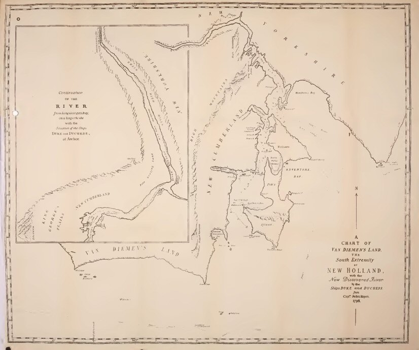
Chart of Van Diemen's Land: The Southern Extremity of New
Holland
from Capt. John Hayes, 1798.
[* There is good reason to believe that Hayes' charts and journals are in the National Library in Paris, or, possibly, in the Department of Marine and Colonies. It would be well if an effort were made to discover them and have them published. See Appendix.]
Lieut. Hayes' ships reached Storm Bay in the year 1794. He had heard of the visit of the French to these shores two years before, but knew nothing of what D'Entrecasteaux had done. He explored and surveyed the approaches of the Derwent, and sailed up that river nearly as far as Bridgewater; while, in the belief that he was making an original discovery, he gave new names to various localities. These have in some instances superseded those bestowed by his predecessor D'Entrecasteaux. Thus it is to Hayes that we owe the name of the Derwent, which has replaced the French appellation of the Rivière du Nord, and D'Entrecasteaux Channel was long known to the English by the name of Storm Bay Passage, which it bears on Hayes' chart. Other names which are still remembered are Betsey's Island, Prince of Wales Bay, Mount Direction, and, lastly, Risdon Cove.** It is said that Risdon Cove and River were named by him after one of the officers of the ship, but this I have not been able to verify.***
[** Adamson's Peak, Mount Lewis, Cornelian Bay, Taylor's Bay, Court's Island, Fluted Cape, Ralph's Bay, were also named by Hayes.]
[*** Mr. Justin Browne informs me that Risdon is a name borne by a county family of Devonshire; (see "Marshall's Genealogist's Guide", p. 524), and that it occurs also as a place name in Gloucestershire, (see also Burke's Armoury, Ed. 18.) The popular derivation from, a supposed "Rest-down" may, perhaps, be credited to the fancy of the enterprising and pugnacious printer, Andrew Bent. So far as I have been able to discover, it first occurs in "Bent's Tasmanian Almanac" for 1827. It has been copied by West and other writers.]
It was in the early spring of the year 1798 that Governor Hunter gave to Flinders—then a young Lieutenant of H.M.S. Reliance—the Norfolk**** a little colonial sloop of 25 tons, to try to solve the vexed question of the existence of a strait between New Holland and Van Diemen's Land. Flinders secured Dr. George Bass as his companion in the expedition, and on the 7th October, 1798, the Norfolk sailed from Port Jackson with a crew of 8 volunteers, taking twelve weeks' provisions. . They examined the North Coast of Tasmania, entering Port Dalrymple, and sailed for the first time through the Straits, to which, at Flinders' request, Governor Hunter gave the name of Bass' Straits.*****
[**** The Norfolk, which has the credit of having first circumnavigated Van Diemen's Land, was built at Norfolk Island, of the pine for which that island is celebrated. She was afterwards used by Flinders in his exploration of Moreton Bay. Labilliere's Early History of Victoria. Vol. i., p. 26.]
[***** "No more than a just tribute", says the generous Flinders, "to my worthy friend and companion for the extreme dangers and fatigues he has undergone in first entering it in the whale-boat, and to the correct judgment he had formed from various indications of the existence of a wide opening between Van Diemen's Land and New South Wales."—Voyage to Terra Australis, Intro., p. 193.]
Leaving Bass' Straits the Norfolk sailed southwards along the West Coast—Flinders naming Mount Heemskirk and Mount Zeehan after Tasman's two vessels—and on 14th December, arrived at the entrance of Storm Bay. Flinders had with him a copy of Hayes' sketch chart of the Derwent, but had never even heard of D'Entrecasteaux's discoveries six years before. Bass, in speaking of Adventure Bay, says—"This island, the Derwent, and Storm Bay Passage were the discovery of Mr. Hayes, of which he made a chart." More than a fortnight was employed by Flinders in making a careful survey of Norfolk Bay, and of the Derwent from the Iron Pot to a point some 5 miles above Bridgewater. In the Introduction to his Voyage to Terra Australis, he gives the result of his observations. Bass devoted his attention more particularly to an examination of the neighbouring country, its soil, productions, and suitableness for agriculture. He took long excursions into the country, having seldom other society than his two dogs, examining in this way the western shore of the river from below the Blow Hole at Brown's River to beyond Prince of Wales Bay, visiting various parts of the eastern shore, and ascending Mount Wellington and Mount Direction. His original journal has never come to light, but the substance of it was published in 1802, by Collins, in the second volume of his Account of New South Wales.
It is interesting to learn how the country with which we are so familiar struck the first visitor to its shores, when as yet the land was in all its native wildness, and untouched by the hand of man, and I shall therefore give some of Bass's observations on the country about the Derwent. The explorers had some difficulty in getting the Norfolk as far up the river as the mouth of the Jordan, which Flinders named Herdsman's Cove. Thence they proceeded in their boat some 5 or 6 miles higher up. They expected to have been able to reach the source in one tide, but in this they were mistaken, falling, as they believed, some miles short of it. I regret to say that Bass did not show the good taste of the Frenchmen who were so enthusiastic on the grandeur and beauty of the harbours and rivers which they had entered. He describes our noble river as a "dull, lifeless stream, which after a sleepy course of not more than 25 or 27 miles to the north-west, falls into Frederick Henry Bay. Its breadth there is two miles and a quarter, and its depth ten fathoms." He further remarks, "If the Derwent River has any claim to respectability, it is indebted for it more to the paucity of inlets into Van Diemen's Land than to any intrinsic merits of its own." Yet his impression of the country on its banks was distinctly favourable. "The river", he says "takes its way through a country that on the east and north sides is hilly, on the west and north mountainous. The hills, to the eastward arise immediately from the banks; but the mountains to the westward have retired to the distance of a few miles from the water, and have left in their front hilly land similar to that on the east side. All the hills are very thinly set with light timber, chiefly short she-oaks, but are admirably covered with thick nutritious grass, in general free from brush or patches of shrubs. The soil in which it grows is a black vegetable mould, deep only in the valleys, frequently very shallow, with occasionally a mixture of sand or small stones. Many large tracts of land appear cultivable both for maize and wheat, but which, as pasture land, would be excellent. The hills descend with such gentle slopes, that the valleys between them are extensive and flat. Several contain an indeterminate depth of rich soil, capable of supporting the most exhausting vegetation, and are tolerably well watered by chains of small ponds, or occasional drains, which empty themselves into the river by a cove or creek." Black swans were seen in great numbers, and kangaroo abounded, but Bass came to the conclusion that the natives must be few in number, as although they frequently found their rude huts and deserted fires, during a fortnights' excursions they fell in with none of the aborigines, except a man and two women, with whom they had a friendly interview some miles above Herdsman's Cove. Bass contrasts New South Wales and Van Diemen's Land in respect of their fitness for agriculture: his opinion was that they were both poor countries, but in point of productive soil the preference was to be given to Van Diemen's Land. He founds on the banks of the Derwent various tracts of land which he considered admirably adapted for grain, for vines, and for pasturage, and no place combined so many advantages as Risdon Cove. Bass grows almost enthusiastic in describing Risdon. "The land at the head of Risdon Creek, on the east side," he remarks, "seems preferable to any other on the banks of the Derwent. The creek runs winding between two steep hills, and ends in a chain of ponds that extend into a fertile valley of great beauty. For half-a-mile above the head of the creek the valley is contracted and narrow, but the soil is extremely rich, and the fields are well covered with grass. Beyond this it suddenly expands and becomes broad and flat at the bottom, whence arise long grassy slopes, that by a gentle but increasing ascent continue to mount the hills on each side, until they are hidden from the view by woods of large timber which overhang their summits The soil along the bottom, and to some distance up the slopes, is a rich vegetable mould, apparently hardened by a small mixture of clay, which grows a large quantity of thick juicy grass and some few patches of close underwood."
Flinders was, however, disappointed with Hayes' Risdon River, and notices the insignificance of the little creek, which even his boat could not enter, and at which he could barely manage to fill his water casks. Among "the many local advantages of the Derwent" to which King alludes in his despatches to Lord Hobart, and which determined him to choose that place for a settlement, there is no doubt that Bass's glowing description of the beauty and fertility of Risdon filled a large place, and induced him to direct Bowen to choose its neighbourhood for the new colony.
It is now time for us to return to Lieut. Bowen and his little colony, whom we left on the 12th September, 1803, in the Albion and Lady Nelson at anchor in Risdon Cove. A week later Bowen writes to Governor King by the Albion, reporting his arrival, and his definite selection of Risdon as the site of the new settlement. He seems to have accepted Risdon as a foregone conclusion, for although he tells the Governor that he had explored the river to a point rather higher than Flinders went, it does not appear that he made any sufficient examination of the western bank. If he had done so he could hardly have written to King—"There are so many fine spots on the borders of the river that I was a little puzzled to fix upon the best place; but there being a much better stream of fresh water falling into Risdon Cove than into any of the others, and very extensive valleys lying at the back of it, I judged it the most convenient, and accordingly disembarked all the men and stores." He could never have written thus if he had examined either Humphrey's Rivulet or the stream falling into Sullivan's Cove. Bowen's choice of Risdon does not lead us to form a high opinion of his qualifications as the founder of a new colony. On the other hand, it is only fair to take into account his difficulties. Doubtless, he felt himself in a great degree bound by the instructions he had received from Governor King to fix on a spot in the neighbourhood of Risdon Cove. He also knew that Bass had carefully examined both shores of the river and had found no place so eligible. Moreover, it would be unjust to judge his choice by our present knowledge. Every settlement in an unknown and thickly wooded country must be more or less tentative, and the objections to the locality were not so evident in its original state as they now are. At present the Cove is silted up in consequence of a causeway having been built across it, but when Bowen entered it it was a fairly deep and commodious harbour. There was much to recommend the site to a new-comer. When the Albion sailed up the Derwent the best valleys running down to the river were full of a dense scrub, most discouraging to a settler, and at that period Risdon probably presented the most open land on this side Herdsman's Cove. It was early spring, and at that season there would be a good stream of water in the creek, the open land of the Risdon valley was covered with rich and luxuriant grass, and higher up the creek was a fair amount of the good agricultural land described by Bass. The unsuitability of the valley as a site for a large town would never occur to Bowen, who was content if he could find for his handful of settlers a sufficient space for their gardens, and a few cornfields to supply their immediate requirements. The small scale of the establishment with which he was entrusted would inevitably limit his ideas. Still, after every allowance has been made, it remains evident that Lieut. John Bowen was not one of the men who are born to be the successful founders of new States.
The site of this first settlement is on the farm so well known as the home of the late Mr. Thos. Geo. Gregson, M.H.A. It lies about two miles from the landing-place of the Risdon ferry. A stone causeway crosses the cove not far from the mouth of the creek. For some 100 or 150 yards before the little stream falls into the cove it finds its way through a small marsh of some 20 acres, shut in on each side by steep hills. In Bowen's time this stream was fresh and clear-flowing; now it is brackish, sluggish, and muddy, choked with weeds and slime, and altogether uninviting in aspect. At the upper end of the marsh, where the valley suddenly contracts, a dilapidated stone jetty marks the old landing-place on the creek, at present quite inaccessible for a boat. On the narrow strip of flat ground between the jetty and the steep hill beyond are the barely discernible foundations of a stone building, the first stone store in Tasmania. From this point a road leads upwards along the hillside for some 150 or 200 yards to the top of the rise, where there is a level piece of land of no great extent, bounded on the north by rough hills, and on the south sloping steeply to the valley. On the edge of this level ground, overlooking the flat, and commanding a fine view of the Derwent and of the mountains behind it, stand some dilapidated wooden buildings, for many years well known as the residence of Mr. Gregson, the little cottage in front being, not improbably, Lieut. Bowen's original quarters. A good garden extends to the rear of the house, and in this garden, about 100 yards behind the cottage, there still stand the ruins of an oven with brick chimney, which Mr. Gregson for many years religiously preserved as the remains of the first house erected in Van Diemen's Land. From this point the valley is narrow, the ground sloping down steeply, but there is good agricultural land in the bottom, and on the northern slope where Bowen's free settlers were located—the other side being stony and barren. A plan which Bowen sent to Governor King enables us to identify the locality with absolute precision. He tells King—"We are situated on a hill commanding a perfect view of the river, and with the fresh water at the foot of it—the land excellent."
After pitching his tents at Risdon, Bowen was not idle. He set his people at once to work to build huts. During the first week he made a boat excursion up the river; examined Herdsman's Cove, and thought of locating his free settlers there. He describes the Derwent as "perfectly fresh" above Herdsman's Cove, and "the banks more like a nobleman's park in England than an uncultivated country; every part is beautifully green, and very little trouble might clear every valley I have seen in a month. There are few rocky spots except on the high hills, and in many places the plough might be used immediately; but our workmen are very few and very bad. I could with ease employ a hundred men upon the land about us, and with that number—some good men among them—we should soon be a flourishing colony." Next week he made another trip up the Derwent, but without further results. He sends King a plan of his settlement,* and already within a fortnight of his arrival he had got quarters built for his soldiers and prisoners, had located his free settlers on their five-acre allotments up the valley about a quarter of a mile from his tent, and had Clark, the stonemason, at work building a stone store.
[* See Appendix.]
He had—probably in accordance with King's instructions—named the new settlement "Hobart",** after Lord Hobart, the Secretary of State for the Colonies.
[** "Town" was not added to the name until some time after the settlement was removed by Collins to Sullivan's Cove.]

Sketch of Bowen's First Settlement at Risdon Cove,
1803.
["The Risdon Settlement"]
His Returns, dated "Hobart, Van Diemen's Land, 27th September, 1803", show an effective strength of 22 men—21 convicts and their overseer—of whom 2 were in charge of stock, 4 employed on buildings, (viz., a blacksmith, carpenter, and two sawyers), the bulk of the convicts forming a town gang. The three women are returned as "cutting grass", probably for thatching. Of the stock, the Government owned 9 cattle and 25 sheep, the Commandant had a mare, and the Doctor a cow, while the Officers and Birt and Clarke, the free settlers, were possessors of 7 sheep, 8 goats, and 38 swine.
Within a fortnight from his landing, as I have said, Bowen had all his people housed, and reports to King that the soldiers and prisoners have got very comfortable huts. He fixed his own quarters on the spot where Mr. Gregson's house now stands; the soldiers' huts were a little behind Dr. Mountgarret's quarters, and the prisoners' huts were placed on the brow of the steep bank overlooking the creek. (See plan). The Commandant tells King that he has not yet drawn any lines for the town, waiting till he can cut down the large timber which obstructed his view. To lay out a town in such a situation must have been a difficult problem; for his little settlement was perched on the top of a high almost precipitous bank, on the edge of a very narrow gully, and the narrow plateau on which it stood, shut in at the back by rough hills, did not afford room for a fair-sized village. But the difficulties of the locality were as nothing to the difficulties of the human material out of which he had to form his colony.
The soldiers of the New South Wales Corps, who formed his guard, and on whom he had to depend for the maintenance of order, were discontented, almost mutinous. Within a week of his arrival they were grumbling at the hard duty of mounting one sentry during the day and two at night. The Commandant thought they had been spoilt by too easy a life in Sydney, and begged the Governor to send him down an active officer or sergeant who would keep them to their duty.
As to the prisoners, they were of the worst class, ill-behaved, useless, and lazy. Indeed, when we find that some of the worst offenders in New South Wales had been sentenced by the Criminal Court in Sydney to serve a certain number of years at Risdon Creek, we cannot wonder at Bowen's complaints of their conduct, nor can we be surprised that he was able to effect so little.
Meanwhile, Governor King did not forget the interests of the new colony. In his reply to Bowen's first letters, he expressed himself as well pleased with the selection of Risdon, and with the progress that had been made with the settlement. He also promised the reinforcements for which Bowen asked, and, accordingly, towards the end of October the Dart brig was despatched to the Derwent. She took 42 prisoners—of whom 20 were volunteers—and these latter were told that, if their behaviour was good, they should be allowed, at the end of two years, to choose between settling at the Derwent and returning to Sydney. The Governor also strengthened the Military force by sending down 15 soldiers under the command of Lieut. Moore. He strongly urged Bowen to leave their discipline entirely to their officer, to give them good huts, full rations, a plot of ground for a garden, and to employ them on military duty only, so that they might have no just ground for complaint. The Dart took six months' supplies of pork and flour for the new arrivals, and also two carronades which had belonged to the Investigator, and as to the care of which King gave the Commandant very special cautions. No more free settlers were sent, as the Governor wished first to get a better knowledge of the country and of its suitableness for agriculture. To this end he sent down James Meehan, a surveyor who had done good work in New South Wales under Surveyor-General Grimes, and had recently formed one of the party who had made the survey of Port Philip in the Cumberland. Meehan was to be employed in surveying and making observations on the soil and natural productions of the colony, and was to advise with respect to the distribution of the town, church, and school lands, fortification, court-house, settlers' allotments, and government grounds for the purpose of agriculture and grazing. He remained some four months at Hobart, returning to Sydney in March, 1804, after having completed the first surveys in Tasmania. Flinders' map shows that Meehan explored from the Coal River in a north-east direction, returning by way of Prosser's Plains and the Sorell District, but we have no particulars of the result of his observations.
Bowen's little colony now numbered something like 100 souls. It had been established about two months, and might fairly have been expected to have made at least a start towards definite progress. But it was pre-destined to failure. The few meagre facts that can be gleaned from the Record Office papers show that matters went most persistently wrong. The Commandant may not have been to blame for this ill success—possibly no man could have achieved success with the like material. The first arrivals had been bad, the second batch was certainly no better. We have Collins' testimony, very emphatically given, that many of them were "abandoned, hardened wretches"—more atrocious than those imported from the gaols of England." The story of the escape of seven of these convicts, under the leadership of one Duce, gives us an idea of their lawlessness, their ignorance, and their utter recklessness. One night, Duce and his six companions stole the Commandant's boat as she lay in the cove, gained possession of two guns, and got away down the river. Some of the party wanted, without compass or provisions, to run for New Zealand, which they thought could easily be done. Others, not quite so ignorant, preferred to try to make Timor. Violent quarrels ensued, but they kept on their course along the east coast, living on fish and such vegetable food as they could collect on the shore, and constantly on the verge of murderous conflict, until they reached Bass Strait. Here one of the party was left on a desolate rock, Duce threatening to shoot any one who interfered. The rest made Cape Barren Island, where they fell in with a sealing party. Duce and three others designed to seize the vessel, but were betrayed by their companions. The sealers overpowered them, and put the four, with some provisions, on one of the islands, where they left them. Whether they perished, or whether they helped to swell the number of lawless runaways who for so long a time infested the islands in the Straits, no one knows.
The soldiers were almost as great a trouble to the Commandant as the convicts. They were always discontented, occasionally mutinous. At times, instead of guarding the stores from depredation, they connived at the prisoners plundering them. An occasion of this sort, when a soldier was proved to have been accomplice in a robbery, led to Bowen taking a very extraordinary step. He could not try the man, not being able to constitute a court-martial, and was so puzzled to know what to do with him, that when the Ferret whaler chanced to put into the Derwent, he actually determined to leave his post, and himself take the culprit to Sydney for trial. Accordingly, he sailed from Risdon for Sydney in the Ferret, on the 9th January, 1804.
With all these signs of the utter disorganisation of the settlement, we cannot wonder that no progress had been made, and that when Collins arrived a few weeks later, he found that after five months' residence not a single acre of land was in preparation for grain upon Government account.
But the Risdon settlement was already doomed, owing to a series of events of which neither Governor King nor his Commandant was yet aware. Before Bowen had made his first abortive start for the Derwent, and before Governor King's despatch of 23rd November, 1802, respecting French designs, could have reached England the Home Government had taken a resolution which—not by any intention of theirs—was destined to bring Lieut. Bowen's colony to an end, by its extinction in a more systematic and extensive settlement on the banks of the Derwent. In January, 1803, an Order in Council appointed Lieut.-Colonel David Collins, of the Royal Marines, Lieutenant-Governor of a settlement intended to be formed at Port Phillip, in New South Wales. The new establishment sailed from Spithead on the 24th April, 1803—a month before King had given Bowen his commission as Commandant of Hobart—had just left Cape Town when Bowen sailed from Sydney in the Albion, and arrived in Port Phillip on the 9th October, 1803.
This is not the place to give an account of Collins' proceedings, at Port Phillip or elsewhere, except in so far as they affected the fortunes of the Risdon settlement. Suffice it to say, that Collins found, or fancied, that Port Phillip was unfit for a settlement, and after corresponding with Governor King, and dawdling near the Heads for some three months, he finally decided to remove his establishment to the Derwent. Thereupon, King sent Collins a letter addressed to Bowen, directing the latter to hand over to Collins his command at the Derwent, and to send back to Port Jackson his detachment of the New South Wales Corps. And so a game of cross purposes began. For while Collins was still fuming and fidgetting at Port Phillip, balancing the comparative advantages of Port Dalrymple and the Derwent, and gradually making up his mind in favour of the latter place, Bowen had sailed from Risdon in the Ferret with his burglarious soldier, and had presented himself to the astonished Governor King at Port Jackson. The Governor seems to have taken no pains to conceal the annoyance he felt at his Commandant leaving his post on so trifling an occasion, and sarcastically remarks in a despatch to Lord Hobart, that Bowen's "return was occasioned by the necessity he conceived himself to be under of bringing up a soldier who had been implicated with the rest in robbing the stores." He was the more vexed at this inopportune return, as he knew that Collins was on the point of leaving Port Phillip, and he was particularly anxious that the Risdon Commandant should be at hand to give the new Lieutenant-Governor the benefit of his experience and knowledge of the locality.
The colonial cutter Integrity had just been launched. She was hastily fitted for sea, and Bowen was ordered to return in her to the Derwent forthwith, calling at Port Phillip to join Collins, to give him all necessary assistance, and accompany him to Risdon. The Integrity sailed on the 5th February; but Bowen's ill luck still attended him. When he reached Port Phillip he found only a remnant of Collins' establishment, under the charge of Lieut. Sladden, the Lieutenant-Governor himself having sailed for the Derwent in the Ocean with the bulk of his people two or three days before. Bowen accordingly hastened on with his despatches, but shortly after sailing the cutter's rudder fastenings carried away, and she was placed in a very dangerous position. However, she managed to reach Kent's Bay, Cape Barren Island, and there they found a sealing party belonging to the American ships Pilgrim and Perseverance. The necessity for getting on was imperative; so Bowen made a verbal agreement with the American skipper, Captain Amasa Delano, to carry them on in his ship, and afterwards, if required, to proceed to Port Jackson. From the diary of the Chaplain of Collins' party, the well known Rev. Robert Knopwood, we learn that the Pilgrim cast anchor in Sullivan's Cove on 10th March, and that at six in the evening, a boat brought ashore "the Governor of Risdon Creek, Lieut. Bowen, of the Royal Navy."
It must have proved a considerable mortification to the Governor of Risdon Creek to learn the events that had occurred during his unlucky absence. Lieutenant-Governor Collins had arrived in the evening of the 15th February, and next morning had landed at the Risdon settlement under a salute of 11 guns from the Ocean. On landing, he had been received by the officer in charge, Lieut. Moore, of the New South Wales' Corps, and the rest of the establishment—consisting of the doctor, storekeeper, and military force of 16 privates, one sergeant, and one drum and fife. After examining the camp, gardens, water, &c., the new Lieutenant-Governor had at once come to the conclusion—which, indeed, was pretty evident—that Risdon was not, in the Chaplain's words, "calculated for a town". Accordingly, on the following day, the Governor, with the Chaplain and Wm. Collins, had gone exploring, and had returned much delighted, having found, at a place on the opposite side of the river, six miles below Risdon, "a plain well calculated in every degree for a settlement." Forthwith the tents of the new establishment had been struck and taken on board the ships, which had dropped down the river to the selected spot, and anchored in Sullivan's Cove. So that on the 20th February—five days after Collins' arrival—his tents had been pitched at the mouth of the creek on the present site of Hobart, and the glory of Risdon had departed.
Bowen's settlement had had its own internal troubles, which, no doubt, Lieut. Moore duly reported to the Governor of Risdon Creek. On the 21st February, the day after the founding of the new Hobart at Sullivan's Cove, a further batch of five convicts had escaped from Risdon, having found means to steal half a barrel of gunpowder from under the very feet of the sentry, and also two "musquets", with which they had got off into the woods. The runaways, however, did not find the woods inviting enough for a permanent residence, and one of them having voluntarily come in, the others followed his example next day, bringing the arms and ammunition with them. It was too troublesome and expensive to send them to Sydney for trial; they were, therefore, heavily ironed, and kept to work as a gaol gang.
The only consolation that the Risdon Governor could have found in his adversity—besides the greater opportunities of good fellowship which were now afforded him, with, no doubt, better fare than the salt pork and bread, which had hitherto been the regulation diet—was the consideration that the religious wants of his people, about which Governor King had been so emphatic, were now under proper regulation, and that on Sundays, when the weather was not unfavourable, the Chaplain, after divine service at Sullivan's Cove, had occasionally gone over to Risdon in the afternoon, and, as he phrases it, "done his duty to all the convicts, &c., &c.", dining afterwards with Dr. Mountgarret.
Captain Delano, meanwhile, was making a good thing out of Bowen's misfortunes. The Integrity was still lying at Cape Barren Island, disabled, and she had to be brought on. So, after enjoying and returning the hospitalities of the place for a fortnight, the American captain sailed again for the Straits, with new rudder fastenings for the disabled vessel, and in less than a month the Pilgrim once more appeared in the Derwent [17th April] with the Integrity in company. The Pilgrim sailed away a few days later to continue her sealing voyage, and her captain carried with him not only the reward of an approving conscience, but also Bowen's bill on Governor King for £400. When the bill was presented in the following August, King's surprise was considerable, and he made some vigorous protests. But the bill was in due form, for services performed, and the Governor had to pay. He could only relieve his feelings by writing to Lord Hobart in strong terms as to the American's conduct; but he says, "I did not consider I could, with that respect due to the British character, either curtail or refuse payment of the bill, notwithstanding the extortionate advantage that had been taken of Mr. Bowen's necessities, and his not entering into a written agreement."
We hear again of Captain Delano and his party a month or two later, and they seem to have been very undesirable visitors. Not only had they been smuggling spirits against the stringent regulations, and decoying prisoners, but they had made themselves still more obnoxious by their brutal treatment of a sealing party at Kent's Bay belonging to the Surprise sloop, of Sydney. According to the statement of the master of the Surprise, he had been flogged and nearly killed by Delano's men for venturing to come into the Straits and interfere with them by killing seals in their neighbourhood. Governor King was inclined to take vigorous measures to put a stop to the lawless conduct which was then only too common amongst the American sealers in Bass' Straits, and proposed to the Home Government that he should be authorised to go the length of seizing their ships as the only means of teaching them better behaviour.
But to return to the fortunes of the Risdon Settlement. Lieutenant-Governor Collins was altogether disappointed with the condition of Bowen's colony, and made a very unfavourable report on it to Governor King. The site was quite unsuitable; the landing-place on the creek was choked with mud, and only accessible at high tide; the stores were placed on a low position, and likely to be flooded by any heavy rain; the land was by no means first class; and the rivulet, on which they depended for their fresh water, and which in September had been a running stream, was in February dwindled to a few pools of dirty water. The indifferent capabilities of the place had not been made the most of. No grain had been sown, and no Government land had been even prepared for sowing. Dr. Mountgarret, and Clark and Birt, the free settlers, had each about five acres ready, but they had no seed, so Collins had to supply them with sufficient to crop their land. The five months' occupation had been wasted; there was nothing to show but a few wretched huts, cottages somewhat better for the officers, and a few acres of land roughly cleared of trees and scrub. The people were in a miserable condition, having been for some time on two-thirds of the standard rations, so that Collins had to supply them with food, and even to remove their starving pigs to his own camp to save their lives. A more dismal failure for a new colony could scarcely be imagined. It is difficult to decide how far Bowen was to blame for this wretched state of things. The human material that had been given him to mould into shape was desperately bad. Collins says that the officer in charge on his arrival (probably Lieut. Moore) described them "as a worthless and desperate set of wretches"; and this language does not appear to have been too strong. The Sydney authorities seem to have taken the opportunity of Bowen's settlement to rid themselves of their worst criminals, including the most turbulent of the United Irishmen, who had lately given so much trouble by their rising in the older colony. Even the soldiers of the New South Wales Corps, sent to curb these undesirable colonists, were lazy and mutinously inclined. It is a satisfaction to know that Collins eventually shipped the whole lot back to Sydney:—both soldiers and convicts, with but few exceptions—so that they never had any part in the new Hobart.
Collins did not interfere with Bowen or with Lieut. Moore in their command, but left them in uncontrolled charge. Indeed, he seems to have been only too anxious to wash his hands of Risdon and all its works. Governor Bowen and the Risdon officers, however, made the best of their circumstances, and, if we can trust the chaplain's diary, took life easily—shooting, hunting, excursionising, and exchanging frequent visits with the officers of the new camp. Towards the end of March Mr. Knopwood goes to Risdon for a few days, and "they caught six young emews the size of a turkey, and shot the old mother." On Easter Sunday [1 April], after Divine Service, they all go to the chaplain's marquee at the camp, and "partook of some Norfolk ham, the best we ever eat". At 4 P.M. he adjourns to Lieut. Lord's to dinner, "and was very merry". Mr. Knopwood records many visits to Risdon, and excursions with Bowen up the river, to Mount Direction, to Ralph's Bay, and other places. "The Governor of Risdon Creek", as Knopwood called him, had, however, enough trouble with his refractory people. His soldiers had long grumbled at the sentry duty as too hard for their small numbers; and the discontent at last broke out into direct mutiny. On Sunday 22nd April, the men flatly refused to mount guard, and became so insolent and insubordinate that Lieut. Moore promptly put four of the ringleaders into irons, and took them down to Sullivan's Cove. Lieut.-Governor Collins sent the mutineers under a guard on board the Colonial cutter Integrity, then on the point of sailing for Port Jackson. At the same time a plot was on foot amongst some of the Irish convicts, at Risdon. Their object was to seize the storehouse, supply themselves with provisions, and make good their escape from the settlement. On the discovery of the plot, three of the ringleaders were forthwith flogged, and, to prevent further mischief, Captain Bowen and Mr. Wilson, the storekeeper, a few days later, took the mutinous prisioners to Norfolk Bay in the Risdon whaleboat. "Eight of them, and all Irishmen", remarks the chaplain. They were left on Smooth Island (now known as Garden Island), with a month's provisions, and Bowen went on to explore the River Huon.
With that fatality which always kept Bowen out of the way when he was wanted, an important and disastrous event occurred at Risdon in his absence. This was the first affray of the English with the natives. It was on the 3rd May, 1804, that this first of the long series of fatal encounters between the two races took place. Up to this time it does not appear that any natives had been seen in the neighbourhood of Risdon. Knopwood relates that there had been some friendly intercourse with the tribe on the other side of the river, and that some of them had come to Collins' camp. We also learn from him that he and Bowen had seen many natives in the neighbourhood of Frederick Henry Bay. The blacks had always shown themselves shy and suspicious, but relations had hitherto been quite friendly. The unhappy event of the 3rd May sowed the seeds of a hostility on the part of the blacks, which, exasperated from time to time by mutual injuries, filled the colony with deeds of outrage and horror, with savage murders of innocent settlers, and almost equally savage retaliation, until the native race was nearly exterminated, and the miserable remnant removed to Flinders' Island, to perish of slow decay. Of the origin of the affray the accounts are very contradictory. Two of these are contemporary; one recorded by Mr. Knopwood in his diary, the other in a letter by Lieut. Moore, the officer in charge of Risdon. The Chaplain says, under date Thursday, 3rd May:—"At 2 P.M. we heard the report of cannon once from Risdon. The Lieut.-Governor sent a message to know the cause. At half-past 7, Lieut. Moore arrived at the camp to Lieut.-Governor Collins, and I received the following note from Risdon:—
DEAR SIR,
I beg to refer you to Mr. Moore for the particulars of an attack the natives made on the camp to-day, and I have every reason to think it was premeditated, as their number far exceeded any that we ever heard of. As you express a wish to be acquainted with some of the natives, if you will dine with me to-morrow, you will oblige me by christening a fine native boy who I have. Unfortunately, poor boy, his father and mother were both killed; he is about 2 years old. I have, likewise, the body of a man that was killed. If Mr. Bowden wishes to see him dissected, I will be happy to see him with you to-morrow. I would have wrote to him, but Mr. Moore waits.
Your friend,
J. MOUNTGARRET.
Hobart, six o'clock.
The number of natives, I think, was not less than 5 or 6 hundred.
J.M."
Knopwood continues:
"At 8, Lieut. Moore came to my marquee, and stayed some time; he informed me of the natives being very numerous, and that they had wounded one of the settlers, Burke, and was going to burn his house down, and ill-treated his wife, &c., &c."
Lieut. Moore's letter—a copy of which is preserved in the Record Office—is dated Risdon Cove, 7th May, 1804, and is addressed to Governor Collins. He says—
SIR,
Agreeable to your desire, I have the honour of acquainting you
with the circumstances that led to the attack on the natives,
which you will perceive was the consequence of their own hostile
appearance.
It would appear from the numbers of them, and the spears, &c., with which they were armed, that their design was to attack us. However, it was not until they had thoroughly convinced us of their intentions, by using violence to a settler's wife, and my own servant—who was returning into camp with some kangaroos, one of which they took from him—that they were fired upon. On their coming into camp and surrounding it, I went towards them with five soldiers. Their appearance and numbers I thought very far from friendly. During this time I was informed that a party of them was beating Birt, the settler, at his farm. I then despatched two soldiers to his assistance, with orders not to fire if they could avoid it. However, they found it necessary; and one was killed on the spot, and another found dead in the valley.
But at this time a great party was in the camp; and, on a proposal from Mr. Mountgarret to fire one of the carronades to intimidate them, they departed.
Mr. Mountgarret, with some soldiers and prisoners, followed them some distance up the valley, and have reason to suppose more was wounded, as one was seen to be taken away bleeding. During the time they were in camp, a number of old men were perceived at the foot of the hill, near the valley, employed in preparing spears.
I have now, Sir, as near as I can recollect, given you the leading particulars, and hope inhere has nothing been done but what you approve of.
I have the honour to be, &c.,
WILLIAM MOORE,
Lieut. N.S.W. Corps.
It will be noticed that in this letter Lieut. Moore, who had every reason to represent the conduct of the natives in the worst light, can show no direct act of hostility. He assumed that they were hostile, from their numbers; and, for the beating of Birt, and the proposed burning of his hut, he has no evidence to offer but a report brought to him in the midst of the panic which the appearance of the blacks had caused among his people. That the doctor's proposal to fire the carronade should have induced savages, who did not understand the language, and had never seen fire-arms, to withdraw, is too great a stretch on one's credulity. We know, from Knopwood, that the gun was fired; but, whether it was loaded with blank cartridge or with grape, we have no means of deciding.
The only other eye-witness of the affair whose account we have directly contradicts Lieut. Moore; and his story looks probable, like the story of a man who had kept his head amidst the general panic. This witness is one Edward White, who was examined before Governor Arthur's Aborigines' Committee in 1830. In considering his evidence, it should be remembered that, at the time he gave it, the exasperation of the whole colony against the blacks, on account of their brutal outrages, was at fever heat, and the witness had every inducement to represent their conduct in this affair in an unfavourable light. White came to the colony with Bowen, and was an assigned servant to the settler Clark. He was the first man who saw the approach of the natives. He was hoeing new ground on the creek near Clark's house, which was about half a mile up the valley behind the camp. As he was hoeing, he saw 300 natives, men, women, and children, coming down the valley in a circular, or, rather, a semi-circular, form, with a flock of kangaroo between them. They had no spears, but were armed with waddies only, and were driving the kangaroo into the bottom. On catching sight of him, they paused, astonished, and, to use his expression, "looked at him with all their eyes." White had very probably been accustomed to the Port Jackson natives; at any rate, he says that he felt no alarm at the approach of the blacks, but he thought it advisable to go down the creek and inform some soldiers. He then went back to his work. On his return the natives were near Clark's house. They did not molest him or threaten him in any way. Birt's house was on the other side of the creek, some hundreds of yards off, and White was very positive that, so far from attacking Birt or his house, they never even crossed over to that side of the creek, and "were not within half a quarter of a mile" of the hut. He knew nothing of their going into the camp itself; but they did not attack the soldiers, and, he believed, would not have molested them. When the firing commenced there were a great many of the natives slaughtered and wounded, how many he did not know.
The Rev. Mr. Knopwood gave evidence before the same committee. He stated that he had heard different opinions as to the origin of the attack; that it was said the natives wanted to encamp on the site of Birt's hut, half a mile from the camp, and had ill-used his wife, but that the hut was not burnt or plundered. They did not attack the camp, but our people went from the camp to attack the natives, who remained at Birt's hut. He thought only five or six natives were killed. The general opinion was that the blacks had gone to Risdon to hold a corroboree.
These accounts throw great doubt on the accuracy of Lieut. Moore's version of the affair. It is significant that Knopwood, who had every opportunity of learning the truth at the time, should state so positively that the natives never left the neighbourhood of Birt's hut, but that the soldiers went out to attack them.
It seems clear that the natives had no hostile intention in their visit, and this was the conclusion of Governor Arthur's committee. Everything goes to show that they were a party coming from the east, probably the Oyster Bay tribe, engaged on a hunting expedition, and that they were more astonished than the English on coming into contact with them. The fact of their having their women and children with them is perfectly conclusive proof that no attack was contemplated. We can easily understand how terrifying to the Risdon people must have been this sudden inroad of a horde of excited savages, yelling and gesticulating. Utterly ignorant of their customs, unable to understand them, or to make themselves understood, the panic of the English, convinced that the natives had collected in force to destroy them, was natural enough. Doubtless the soldiers shared in the general scare, and, moreover, were probably quite inclined to take pot shots at the black savages. But Lieut. Moore ought not to have lost his head. He, at least, should have grasped the situation, and restrained his men. A little more presence of mind on his part, the exercise of a little tact and forbearance, and a collision would have been avoided, the natives would have been conciliated, and the history of the black race in Tasmania might have been different. That the aborigines of Tasmania would, in any case, have melted away before the white man, as the aborigines of the other colonies are melting away, is certain; but if it had not been for Lieut. Moore's error at Risdon, a war of extermination, with all its attendant horrors, might have been averted.
There is little to add respecting this occurrence, except that, according to White, some of the bones of the slaughtered natives were sent in two casks to Port Jackson by Dr. Mountgarret, and that the chaplain, ever anxious to extend the bounds of his church, records that he went to Risdon a week later and "xtiand a young native boy whose name was Robert Hobert May"—the good chaplain having thus the honour of bestowing his name on this first innocent aboriginal Christian. Collins tells Governor King that the baptism had taken place without his knowledge or consent, and when he found that Dr. Mountgarret intended to take this two-year-old native to Sydney, he had the boy brought to the camp, and directed that he should be returned to his own people, for fear they should think he had been killed and eaten by the English. "For," he remarks, "we have every reason to believe them to be cannibals, and they may entertain the same opinion of us." * The incident made Collins very apprehensive of further attacks; and, indeed, a few days after this affray the crew of the cutter, while collecting oyster shells on the river bank opposite Hobart, was attacked by a numerous party of natives, and beaten off with stones and clubs.
[* There is no foundation for this opinion]
As I have already observed, Lieut.-Governor Collins was very reluctant to have anything to do with the Risdon people and would willingly have shipped them all off to Port Jackson; but he now received express and positive instructions from Governor King to take over the command; and, accordingly, on the 8th May (immediately after Bowen's return from the Huon), a General Order was issued, notifying that he had taken upon himself the command of Risdon; that Lieut. Bowen was to continue in the direction of the settlement under him until further orders, and that the officers and prisoners were to return to Port Jackson in the Ocean. The stores were immediately removed to Sullivan's Cove, the few remaining prisoners being victualled from the Hobart camp. The stock was also removed—17 head of cattle, and 45 sheep and lambs; and, a few days later, the whole of the prisoners were removed to the camp, where they could be kept at work in one gang, under a strict guard and a vigilant overseer.
Although Collins badly wanted more military, he did not care to keep the small detachment of the New South Wales Corps, as he had at first thought of doing; for, out of the 23 soldiers, one had been taken to Sydney by Bowen for robbery, and he himself had sent four others thither on a charge of mutiny. He, therefore, determined to despatch them all to Sydney, where a Court Martial could be assembled to correct and punish their evil propensities. Of the convicts, 50 in number, there were only 11 men and 2 women whom the Governor deemed it expedient to keep.
It was not until the 9th August that the Ocean got under way for Sydney, and carried with her the whole civil and military establishment,—Capt. John Bowen, Dr. Mountgarret, Wilson the storekeeper, the turbulent soldiers and the mutinous convicts, 40 or so, who had formed the first Settlement in Van Diemen's Land. Thus ended the first and abortive Hobart.
The only free settler who remained was Richard Clark, who had been made superintendent of stonemasons. Both King and Collins speak highly of his character and capacity. Collins gave him a similar position in the new Hobart at Sullivan's Cove; and in this office he acquitted himself well. A few sheep were given him, and a location of 200 acres on the other side of the river, nearly opposite Hobart.
The other settler, Birt, had applied for and obtained leave to remain; but at the last moment he changed his mind, and sailed with the rest in the Ocean, which brought him under the displeasure of Governor King, who refused to allow him a grant of land. Dr. Mountgarret, also, at first desired to stay, as he had been combining commerce with medicine, and had a large stock on hand which he wished to dispose of; but he, eventually, changed his mind, and he also sailed in the Ocean.
The net balance of the Risdon Settlement, therefore, remaining with Collins, was Richard Clark and the 11 male and 2 female convicts above mentioned. Collins afterwards ordered all the houses at Risdon to be pulled down; but it does not appear whether this was carried into effect. The Ocean did not arrive in Port Jackson until the 23rd August, King having almost given her up for lost. Dr. Mountgarret got a fresh appointment as Surgeon to the new Settlement at Port Dalrymple, under Lieut.-Colonel Paterson.
Lieut. Bowen had left a mare at the Derwent for which he had paid £120, and he offered her to King at that price. The Governor agreed to purchase her on Government account, and paid Bowen with four cows, which he stopped out of his next shipment to Collins. This was the first horse taken to Van Diemen's Land.
It only remains to state what more we know of the Governor of Risdon Creek. On his arrival at Sydney he was desirous of returning to England, in order that he might again enter on active service in the navy. Governor King had offered him the munificent pay of 5s. per day from the 30th June, 1803, when he first sailed from Sydney in the Porpoise, to the 24th August, 1804, when he returned thither in the Ocean, viz., 420 days, at 5s. per day, or £105—exactly one hundred guineas for 14 months' governorship—certainly not an extravagant salary for a governor—not enough to pay his passage to England. He refused the colonial pay offered, and addressed a letter to King, in which he reminds the Governor that pecuniary considerations had not been in his view in accepting the appointment, but simply the advancement of his interest in His Majesty's naval service; but that, as he had been at great expense consequent on that appointment, he trusted the Governor would recommend him to the Home authorities for a sufficient remuneration. King enclosed the letter to Lord Hobart, strongly recommending the application, as he believed Bowen had done his utmost to forward the service he undertook, and expressing a hope that, in addition to this, his character, and that of his father and other relatives in the navy, might open a way for the promotion he was so anxious to obtain. King also paid his passage home in the Lady Barlow, amounting to £100.
It would seem that Lieut. Bowen obtained the promotion he sought. Jorgensen—who, however, was not the most accurate of men—states in his autobiography that the Commandant of Risdon was a son of Commissioner Bowen. Mr. Leslie Stephen's "Dictionary of National Biography", in a notice of Captain James (afterwards Admiral) Bowen, who performed brilliant services at sea during the French wars, mentions the fact that he was one of the Commissioners of the Navy from 1816 to 1825, and that his son John, also a captain, after serving in that rank through the later years of the war, died in the year 1828.
With this brief notice of its founder, I close the story of the first settlement at Risdon Cove.
CAPTAIN HAYES' CHARTS.
A manuscript map, evidently the result of Lieut. Hayes' surveys of the Derwent, was recently discovered by Mr. James R. M'Clymont in the National Library. Mr. Alfred Mault has obtained, through his friends in Paris, a fac simile of this map, which he has courteously placed at the disposal of the Royal Society, and a photo-lithograph of it will appear in this year's volume of the Society's Proceedings. The map bears the imprint of A. Arrowsmith, London, but apparently was never published. Mr. Mault thinks it is Lieut. Hayes' own draft of his chart prepared for publication. This is probable; but the map in question is not identical with the sketch Flinders refers to, since that sketch showed Risdon Cove, which does not appear in Mr. Mault's fac simile. His Excellency the Governor has kindly interested himself in the matter, and it is probable that, through his influence, some further information respecting Hayes' expedition may at last be brought to light.
Population of the Australian Colonies at the time of the Risdon Settlement (1803):—
| New South Wales | 7134 |
| Norfolk Island | 1200 |
| Van Diemen's Land | 49 |
| ——— | |
| TOTAL | 8383 |
See Collins' "Account of New South Wales", ii., 333.
"THE FRENCH IN VAN DIEMEN'S
LAND."
(See Royal Society's Transactions, 1888.)
P. 101, Note.—The name "Australia".—In a despatch to Lord Bathurst, dated April 4th, 1817, Governor Macquarie says—"The Continent of Australia, which, I hope, will be the name given to this country in future, instead of the very erroneous and misapplied name hitherto given it, of New Holland, which, properly speaking, only applies to a part of this immense continent."—Labilliere's "Early History of Victoria", i., 184.
P. 100, line 3.—"Quiros' Terre du St. Esprit, the coast between Cooktown and Townsville."—It is so placed by De Brosses in the chart appended to his "Navigations aux Terres Australes". It is now identified as the island of Espiritu Santo, one of the New Hebrides group.
P. 103, line 16.—"Cox (1789)."—Through inadvertence Cox is mentioned as having touched at Adventure Bay. He did not enter Storm Bay, but visited Oyster Bay and Maria Island.
P. 110, line 9.—"In spite of his safe conduct from the French Admiralty, [Flinders'] ship was seized as a prize."—In a pamphlet published in Sydney in 1886, containing a summary of the contents of the Brabourne Papers, it is stated that amongst the despatches carried by the Cumberland was one from Governor King pointing out the opportunities which Port Jackson afforded for the concentration of troops, which might at any time be sent against the Spaniards in South America, and it is suggested that the discovery of this despatch amongst Flinders' papers gave Governor De Caen a plausible excuse for the detention of the English navigator. It is difficult to believe that this surmise has any sufficient foundation, since, if such a despatch had come to the hands of De Caen, he would certainly have produced it as a justification of his action, and would not have been driven to the paltry pretext drawn from an entry in Flinders' journal.
It may be mentioned that in a paper dated 1809—while Flinders was still a prisoner—Governor King states that there was no doubt that the French entertained the design of attacking New South Wales from Mauritius. He says that Baudin had taken correct plans of Port Jackson, and had explored the passage to Mauritius through Bass Straits, and that, had he lived another year, the Commodore would most likely have visited the colony for the purpose of annihilating the settlement.—Labilliere's "Early History of Victoria", i., 121. See also Jorgensen's Autobiography in Ross's "Hobart Town Almanack for 1835", p. 138.
BY JAMES BACKHOUSE WALKER.
Read 14th October, 1889.
On the 30th January, 1804, the Ocean and Lady Nelson, with the first detachment of Lieut.-Governor Collins' establishment, sailed from the Heads of Port Phillip for the Derwent. The Lady Nelson was commanded by Lieut. Simmons, with Jorgen Jorgenson as first mate. She took the settlers and their families, and the stores. The Ocean had on board 178 prisoners, with some women and children, a guard of 25 marines, under Lieut. Edward Lord, and the civil establishment, consisting of the Lieut.-Governor, the Rev. Robert Knopwood, Surveyor-General Geo. Prideaux Harris, Mr. Adolarius W. H. Humphreys, the Mineralogist, Dr. Bowden, and two Superintendents of Convicts. The ship was greatly overcrowded. She had been fitted up in England to carry some 30 people besides her crew. She had now over 200 souls on board, and we can well believe Mr. J. P. Fawkner when he says that they had a miserable time of it during their 15 days' passage, cooped up in a small vessel of 480 tons. Fawkner says they suffered terribly from the want of cooked food, as the cooking accommodation for 25 had to serve for the whole 200. They were 10 days reaching the Pillar, and were there caught in a heavy south-wester, which kept them two days off the Raoul. It then came on to blow hard from the north-west, which obliged Capt. Mertho to bear up for Frederick Henry Bay, where he came to an anchor off Pipe Clay Lagoon. Here Lieut. Lord and Mr. Humphreys were landed, with four men, to walk up to Risdon with despatches, while the vessel lay wind-bound for another three days, the officers amusing themselves by going ashore, where they were very much pleased with the appearance of the country and the abundance of game and wild fowl. The boat's crew filled their boat with fine oysters in half an hour on the shores of the lagoon. They also fell in with a party of 17 natives, who were very friendly. On the 5th February a change of wind enabled them to make the entrance of the river, where they were met by the boat of the Lady Nelson, which had arrived before them, and they ran up before the sea breeze, anchoring at half-past six in Risdon Cove, off the settlement of which Lieut. Moore was in charge, Lieut. Bowen being absent at Port Jackson.
At 10 the next morning, the Lieut.-Governor, with Lieut. Lord and the Chaplain, landed under a salute of 11 guns from the Ocean—the first salute fired in the Derwent—to inspect the Risdon settlement. They were received with military honours by Lieut. Moore and the 16 privates of the New South Wales Corps drawn up under arms. After inspecting the settlement, the Lieut.-Governor came to the conclusion that Risdon was not a suitable site for a town, and returned on board the Ocean very much disappointed. It was the report of the advantages of Risdon that "had led him to decide in favour of the Derwent rather than the Tamar, and now he had brought his people to a spot that promised as little as the abandoned Port Phillip. However, the next morning was bright with sunshine, and as he looked out over the waters of the Derwent, with its picturesque scenery of hill and valley and thickly wooded plains, things looked less gloomy. To be prepared for the worst, he directed the tents to be pitched at Risdon. Then the boat was ordered out and put in charge of the trusted William Collins, and the Governor, taking with him his favourite companion, Mr. Knopwood, was pulled down the river to a cove on the opposite shore some five miles below Risdon, and which had probably attracted attention on the way up. Here Collins landed, and, after a short examination, made up his mind that it was the very place for his settlement. We can imagine his admiration of the fine cove, with deep water up to the shore, and his profound satisfaction, after four months on the dry sandhills of Sorrento, at finding himself on a well-wooded and fertile plain, lying at the foot of the great Table Mountain, and watered by a copious stream of splendid fresh water. In his first despatch to Lord Hobart, he says that the situation was all he could wish. There was land of good quality immediately about him sufficient for extensive agricultural purposes. The timber and stone were in sufficient quantity and quality for all his needs, and the cove would make an admirable harbour. Knopwood describes the site, not very accurately, as an "extensive plain, with a continual run of water, which comes from the lofty mountain much resembling the Table Mountain at the Cape of Good Hope. The land is good, and the trees excellent. The plain is calculated in every degree for a settlement. At five we returned and dined with the Governor, much delighted with the excursion." Collins devoted another day to the examination of a plain further up the river—probably in the neighbourhood of Glenorchy—which, he thought, might serve for the location of his free settlers. The trees were large and good, but the ground was so cut up by torrents that he decided it to be unsuitable. In the meantime the officers had been sent to look at the first site, and they returned with their unanimous approval of it. The Governor forthwith ordered the tents to be struck and sent on board the Lady Nelson, and the two ships were moved out of the cove. On the Sunday morning, in a strong northerly breeze, they dropped down the river and anchored off the bay, to which the Lieut.-Governor gave the name of Sullivan's Cove, in honour of his friend Mr. John Sullivan, the Permanent Under-Secretary at the Colonial Office.
Monday morning (20th February) was squally and wet, but in the afternoon the weather cleared, and a body of prisoners with a military guard was landed to pitch the tents on the selected site. At four o'clock the Lieut.-Governor himself, with his officers, went on shore for a short time to superintend operations. That night the marines and convicts slept at the new camp—the first Europeans to sleep on the site of the future capital of Tasmania.
In a despatch to Governor King [29th Feb., 1804], Collins gives a description of the Cove in its original state. "In the centre of the Cove", he writes, "is a small island, connected with the mainland at low water, admirably adapted for the landing and reception of stores and provisions. Round this island is a channel for a boat, at the head of which is a run of clear fresh water, proceeding from a distance inland, and having its source in a rock in the vicinity of Table Mountain. The ground on each side of the run is of gradual ascent, and upon that next the Cove I have formed my camp. The Ocean and Lady Nelson are lying within half a cable-length of the shore in nine fathoms water." The inhabitants of Hobart will hardly recognise their harbour in Collins' description. The filling up has been so considerable as to obliterate the original natural features. The creek has been diverted from its course, and the island, which Collins named Hunter's Island, after his old patron, has been swallowed up in the Old Wharf. Originally the Cove was much more extensive than it is at present. The island, which now forms the extremity of the Old Wharf, was then in the middle of the bay. This island was connected with the mainland by a long sandspit, covered at high water, and the site of which is now occupied by the long range of stores forming the Old Wharf. The bottom of the Cove was marked by a yellow sandstone bluff, since cut away, and now forming the cliff overhanging the creek at the back of the hospital. A little below this was the original mouth of the creek, which issued out of a dense tangle of tea-tree scrub and fallen logs, surmounted by huge gum trees. It fell into the river just at the intersection of Campbell-street and Macquarie-street, at the lower angle of the New Market building. The land at the creek mouth was flat and marshy for some distance. On the side towards the town the beach curved round the site of the old Bonded Stores, thence, along a slope covered with gum trees, by the back of the Town Hall, by Risby's Sawmill and the Parliament Houses, past St. David's churchyard, and thence along the line of stone stores on the New Wharf to the Ordnance Stores, and round the old Mulgrave Battery Point. On the side of the creek towards the Domain was a low swampy flat, extending over Wapping and Lower Collins and Macquarie streets to the Park-street Rivulet and the present bridge leading to the Domain. Thence the beach ran round the foot of a wooded slope by the present Gas Company's office, along the course of the railway embankment, to Macquarie Point.*
[* I am indebted to my friend Mr. Mault for a beautifully executed plan (see Appendix) which shows very clearly the original features of the ground, and the position of the first camp, and also indicates the alterations which have since taken place. It is taken from a survey made by Surveyor-General Harris in 1804-5. The original plan was discovered many years ago in the Lands Office at Sydney, and was presented by the New South Wales Government to our Lands Department. The Deputy-Commissioner of Crown Lands, Mr. Albert Reid, kindly presented me with a tracing of it.]
On Tuesday, the 21st February, 1804, the Ocean and Lady Nelson were warped up to within half a cable length of Hunter's Island, the rest of the people were landed, and the discharge of the stores began. The Lieut.-Governor's tent was pitched on the slope overlooking the cove near the spot where the Town Hall now stands. The Chaplain's marquee was pitched next to the Governor's, and those of the other civil officers in close proximity on the same slope. The tents of the convicts were further inland, extending from about the present Telegraph Office at the corner of Macquarie and Elizabeth streets, back to Collins-street to the edge of the scrub in the valley of the creek. The camp of the marines was placed higher up towards the Cathedral. On the Tuesday night, Knopwood says, "I slept at the camp for the first time, and so did the Lieut.-Governor." Jorgensen, who, as mate of the Lady Nelson, had assisted at the settlement of Risdon in the preceding September, and was now in the same capacity assisting at the founding of Hobart, gives us a graphic sketch of the scene on that first day. As soon as the tents had been pitched under the shadow of the great gum-trees, spades, hoes, saws, and axes were put into the hands of the prisoners, and they began clearing away as fast as they could. The block just opposite the Tasmania Museum, behind the old Bank of Van Diemen's Land building to the neighbouring mouth of the creek, was then an impervious grove of the densest tea-tree scrub, surmounted by some of the largest gum-trees that this island can produce. All along the rivulet, as far up as the old mill beyond Molle-street Bridge, was impassable from the denseness of the scrub, and the huge collections of fallen trees and dead timber which had been washed down the stream and were strewed and piled in confusion in its bed. In many places the stream was dammed back, and spread out into marshes covered with rushes and water.
Governor Collins had amongst his various stores a small printing press, which had already done service at the Port Phillip camp. This was set up under a convenient gum-tree, and on the day of landing the first printed work issued from the Tasmanian press. It was a General Order, fixing the weekly rations to be issued to each person—viz., 7 lbs. beef or 4 lbs. pork, 7 lbs. flour, and 6 ozs. sugar. The second day's Order, with a backward glance at the casks sunk at the foot of the Port Phillip sandhills, expressed the Governor's satisfaction at having been enabled to fix the settlement advantageously, and in a situation blessed with that great comfort of life, a permanent supply of pure running water, and cautioned the people against polluting the stream. On the third day the hours of labour were fixed. The Lieut.-Governor having thus given his people some elementary lessons, enforced by appropriate sanctions, on the mutual rights and duties of the individual and the State, proceeded to care for their spiritual requirements, and on the fourth day issued an order for a general muster of the prisoners, and notified that on Sunday, weather permitting, divine service would be performed, at which all were expected to attend.
Hunter's Island had been appropriated for the site of the store tents, for which purpose it was admirably adapted, not only on account of its handiness as a landing place, but also because its isolated position made it comparatively safe from plunderers. All available hands were now employed to discharge the stores. The ships were moored at a short distance from the shore, and the cargo taken off in boats. A wharf was begun at the landing-place on the island, and a way was formed along the sandspit by means of which the mainland could be more conveniently reached at low tide. These works were placed under the superintendence of Mr. William Collins, the hero of the boat expedition to Port Jackson, and who had already given the Governor many proofs of his capacity. Even the Chaplain, usually the only idle man in the settlement, found employment during the first week. His diary tells us that it cost him three days' work to prepare a sermon worthy to be the first preached in the new colony. On Sunday, then, under the gum-trees on the slope near the Governor's tent, overlooking the waters of the Derwent sparkling in the bright February sunshine, the military paraded, the prisoners were drawn up, the officers and settlers formed a group apart, and the Rev. Robert Knopwood conducted the first service in Tasmania. "The sermon, by request of the Lieut.-Governor, was upon the prosperity of the new settlement, and to pray to God for a blessing upon the increase of it." This first Sunday had, however, practical duties, and after service the Ocean's boats moved the settlers, with their families and baggage, to the spot which had been fixed upon for them on the shores of New Town Bay, then known as Stainsforth's Cove, not far from where the Risdon Road leaves the Main Road.

Composite Map of Early Hobart and Sullivan Bay
On the same day the first census was taken, and it appeared that the population consisted of 262 souls, of whom 15 were women and 21 children.*
[* Number victualled at Sullivan's Cove, Derwent River, 26th February, 1804:—
| Quality. | Men. | Women. | Children. ——————————————— |
||
| Over 10. | Over 5. | Under 5. | |||
| ——————————————— | ——— | ————— | ————— | ————— | ————— |
| Military Establishment | 26 | 1 | — | — | — |
| Civil | 6 | — | — | — | — |
| Settlers | 13 | 5 | 8 | 2 | 3 |
| Convicts | 178 | 9 | 2 | — | 6 |
| Supernumeraries ** | 3 | — | — | — | — |
| ——————————————— | ——— | ————— | ————— | ————— | ————— |
| TOTAL | 226 | 15 | 10 | 2 | 9 |
| [** Mr. Brown, Botanist. |
| Henry Hacking. |
| Salamander, a Port Jackson Native.] |
Of the group who landed at Sullivan's Cove in February, 1804, with our first Governor, the best remembered, and, indeed, the only one of whom tradition has anything to say, is the Chaplain, the Rev. Robert Knopwood. The survivor of all Collins' officers, he lived to times well within living memory, and many an old settler still tell stories of his eccentricities. His spare wiry little figure, on the well-known cream-coloured pony, is familiar to us from Mr. Gregson's painting, taken in his later days when the camp had grown into a town, and he had bachelor quarters at Cottage Green, Of his qualifications as the spiritual guide of the young colony not much can be said, and of this he must have been fully sensible if the tradition is correct which reports his favourite saying to have been, "Do as I say, not as I do." The choice of Mr. Knopwood as Chaplain was an unfortunate one. There was a fine field in those early days for a man who would have devoted himself—as Bishop Willson and others did in later years—with wise enthusiasm to the elevation of the society in which his work lay. It is doubtful whether Mr. Knopwood, clergyman though he was, ever made any serious attempt to raise the moral or religious tone of the community. He had been a chaplain in the navy, and, like too many chaplains of those days, was content to acquiesce easily and without uncomfortable protestations in the ways which were current. As a colonist, or in any other capacity than a clergyman, he would have been valuable; as a chaplain he was a failure. Yet he was a genial little fellow, fond of good company and of a good dinner, not averse to a glass of good wine or a pipe with a friend, a lover of animals, an ardent sportsman, of a kindly nature, always ready to give good-natured help to any one in need. In spite of his grave deficiencies, and the conviction that he would have been better in a secular calling, one cannot help having a kindly feeling for the man who was always popular in the settlement, and was long familiarly remembered amongst early settlers as "Old Bobby Knopwood". The diary of the chaplain is the only contemporary material, except grave official documents, which we have for the history of the founding of Hobart. It runs to the end of 1804. The entries are meagre, and too much limited to records of dinners and the interchange of hospitalities amongst the officers; yet it is naive and candid, and supplies interesting detail. Official records are dry reading, but even they yield unexpected treasures to careful study; and, from the early despatches of Lieut.-Governor Collins to Governor King and Lord Hobart, and from Collins' General Orders, with occasional side-lights from the Chaplain's diary, we can form an idea of life in the quaint little camp which at the beginning of this century was pitched on the narrow rise between the waters of Sullivan's Cove and the thick belt of tea-tree scrub shading the course of the Hobart Creek.
The Governor had planted his settlers at a safe distance at New Town Bay, and his total strength at Sullivan's Cove consisted of 178 convicts and the guard of 25 marines under Lieut. Edward Lord. The selection of prisoners for the settlement had been very carelessly made. The frequent burden of Collins' complaint to the Colonial Office is that he was encumbered with so many old, worn out, or useless men, who ate the precious provisions, better bestowed on artificers and stout labourers. Out of the whole 307 men who sailed with him 137 were labourers, but the trades useful in a new colony were very insufficiently represented, and the weavers, silversmiths, engravers, and clerks supplied to him by the authorities with more than sufficient liberality were likely to have long to wait before finding scope for their talents. In fact, the usual official bungling was exemplified in the new colony. The stores supplied by contract were as bad as usual. The Governor makes an exception in favour of the provisions, which he says were excellent, the salt beef and pork being better than any he had seen in New South Wales. But with respect to the other stores he has one long complaint to make. The tools were bad; the axes so soft that the commonest wood would turn their edges; of the gimlets scarce one in a dozen would stand boring twice. The materials for clothing were of poor quality, and the thread rotten. The shoes were made of inferior leather, and were all of one size. The surgical instruments were of an obsolete pattern, and many of them worn out. The iron was rolled and not wrought, while neither glue, borax, resin, nor bar steel had been thought of, so that the carpenters and smiths were in difficulties. The ordnance that had been given him for defence was incomplete, the guns of different sizes and patterns, while the ammunition was all of one sort. The seed corn brought from England would not vegetate, and if it had not been for some good seed which he obtained at the Cape, and some more which Governor King sent him, he could not have raised a crop of wheat. Except the provisions, the printing press was the only item of which he could speak with satisfaction, but for this they had not given him a sufficient supply of type or of paper. Of course, when the contractors were communicated with they all protested that the goods were carefully selected, of a quality superior to the pattern, and quite equal to those which the convicts had had heretofore. Perhaps this last statement was correct.
In spite of these minor difficulties, the work of settlement and improvement was pushed on with an energy and system presenting a strong contrast to the inaction and disorder of the Port Phillip camp. When the landing jetty at Hunter's Island was completed, all the strength that could be spared from the work of clearing was bent to the building of a Government House. He had 178 men in all, but when the necessary deductions were made for overseers, servants, cooks, boats' crews, labourers clearing away scrub or employed in other necessary work, and for the sick—always a large item, owing to the prevalence of scurvy and other ailments induced by the exclusive use of salt provisions—it will be seen that no large number would be left for the actual work of building.* It is most probable that the Governor selected and brought with him in the first detachment all the skilled workmen, leaving the most useless at Port Phillip with Lieut. Sladden; but still the number available was small.
[* See Appendix: Return of Employments.]
No idle time was allowed in the settlement. The bell rang at five in the morning, and the convicts turned out, clad in blue kersey jackets and trousers, and proceeded at once under their overseers to their various employments. Work was continued, with intervals of an hour for breakfast and an hour and a half for dinner, until six o'clock in the evening, when the bell gave the signal for the close of the day's labour. On Tuesday an extra hour was allowed for the issue of rations; Saturday was a half-holiday after 11 A.M.; and it was only under exceptional circumstances that any labour was required on Sunday.
There was ample work for all hands. A large proportion of the people had to be employed clearing away and burning the scrub, grubbing stumps, trenching, digging and preparing garden ground. Building operations were necessarily slow. A quarry had to be opened on the sandstone point near the mouth of the creek to supply stone for foundations. Oyster shells were gathered from the beaches and burnt for lime. Governor King had sent a quantity of bricks from Port Jackson, and these were utilised for chimneys. The fine gums on the banks of the creek furnished an abundant supply of good timber. Stringent regulations were enforced against the useless destruction of the timber, and no trees might be felled without the permission of the Superintendent of Carpenters, to which office the Governor had appointed Mr. Wm. Nicholls, who had come out in the Ocean as a free settler. With the inferior axes supplied by the Government contractors, and which had their edges turned by the hard gum wood, felling was a tedious operation; and when the trees were felled and sawn into lengths, the logs had to be dragged to the sawpits by hand labour, and the sawn timber carried thence by the same means, for as yet there were neither horses nor oxen in the colony. The sawyers, of whom it appears there were nine, were constantly employed at the saw-pits cutting the logs into posts and planks—two men at each log with a ripping saw—in the slow and laborious method so familiar to those whose memory goes back to the days when steam sawmills were not. The progress at the sawpits was so slow that the Governor, notwithstanding his preference for day work, found it necessary at a later period to put the sawyers on task work; and no sawyer was allowed to work for his own profit unless he and his mate had turned out at least 400 feet of sawn timber in the week on the public account. It speaks well for the industry of the community and the energy of the administration, that the sawyers, carpenters, and other mechanics made such good progress with their work that in less than three weeks from the day of landing Government House was completed, and the Chaplain records in his diary on the 9th March, "The Lieut.-Governor slept in his house for the first time." This first wooden Government House was not on the same site as the brick building of later years, but stood on the spot now marked by the main entrance of the Town Hall.
So soon as the Lieut.-Governor had got his house built he turned his attention to agriculture. A gang of some thirty men was sent to prepare ground for wheat for the use of the settlement. The place chosen was near the locations where the settlers had been set down a month before, on the shore of a bay named Farm Bay. This appears to have been at Cornelian Bay, at what was long known as the Government Farm, but is now occupied by the Cornelian Bay Cemetery. The farm was placed under the charge of Mr. Thomas Clark, who had been brought out from England as Agricultural Superintendent.
Collins' next care was to get his people housed under better shelter than canvas tents afforded. They were encouraged to use their spare time in building huts. This was an employment for Saturday afternoons, for Sundays—after service, when that was held—and for the occasional holidays allowed for the purpose by the indulgence of the Governor. The huts were of most primitive construction, being for the most part what old settlers will remember under the name of wattle-and-dab—or wattle-and-daub—with a rush thatch. Let me give you an idea of what a wattle-and-dab hut was like, and how it was built. Four corner posts were stuck in the ground, and upon these wall-plates were rested or nailed; further uprights were then added, and long rods of wattle from the bush were interwoven with the uprights, openings being left for door and windows. Mortar was then made of clay and loam, into which was mixed and beaten up wiry grass chopped up as a substitute for hair. This mortar was dabbed and plastered against the wattles outside and in, the roof covered in with flag-grass, a chimney built of stones or turf, a door and window added, the earthen floor levelled, and a coat of whitewash completed the cottage. It is said that the first house in Hobart was a wattle-and-dab hut built by Lieut. Lord on land adjoining Macquarie House. In less than two months after the Ocean and Lady Nelson had anchored in Sullivan's Cove the huts were completed and the people were all provided with fairly comfortable habitations, occupying a line from the Commercial Bank to the Hobart Club in Collins-street, and thence along the edge of the scrub to the Australian Mutual Provident Society's Building. A General Order of 17th April enjoins strict attention to the cleanliness and order of the huts, and to precautions against danger by fire.
When the huts were finished the prisoners were at liberty to work in their spare time for the officers and settlers, in clearing locations, preparing and fencing in gardens, trenching and hoeing the ground for corn or vegetables, and building houses. Labour was scarce, and the demand being greater than the supply, the work people were not slow to take advantage of the necessity by demanding exorbitant prices for their labour. The abuse became so considerable that by General Order (1st June), the Lieut.-Governor appointed a Committee composed of the civil and military officers, together with three of the settlers, to meet on Sunday, after service, and fix the rate of wages. The new prices for labour were promulgated by General Order of 22nd June. Mechanics for the day of 10 hours were to be paid 3s. 6d., and labourers 2s. 6d. For felling and burning timber, 30s. per acre; for grubbing and burning, £4 per acre; for breaking up new ground, £2 per acre. For reaping wheat, 10s. per acre. For sawing, 8s. 4d. per 100 feet. Splitting 7-feet palings, 3s. per 100; 5-feet palings, 1s. 6d. per 100. Oyster shells for lime, 3d. per bushel. Thatch, 6d. per bundle of 9 feet girth. The workmen were often paid for their labour in provisions, and the Order fixed the following equivalent rates:—Salt beef, 9d. per lb.; salt pork, 1s.; kangaroo, 8d. per lb.; flour, 1s. per lb. So that for a day's work of 10 hours, a labourer could procure 1 lb. of pork and 1½ lbs. of flour, and a mechanic 2 lbs. of beef and 2 lbs. flour. Payment for labour, however, was often made in a more objectionable medium, raw spirit. At a very early period the Governor issued a stringent order against this most pernicious practice. Nevertheless, in spite of Government regulations it continued to be a crying evil, and for many a long year the abuse continued. Many a Hobart building has been paid for in rum. More could be got for spirits than for cash. A bottle of rum was long recognised currency for £1, or even a higher value. It is probable that very little labour in those early days was paid for in cash. The want of specie prevented the payment of the salaries of the officers and superintendents, and to meet this difficulty, and to supply the officers with the means of purchasing necessary articles brought by vessels coming from Sydney, the Commissary was directed to issue small promissory notes of not less than £1 sterling in value. These were to pass in circulation until specie was sent out.
The little camp on the hill above Sullivan's Cove must have been a grotesque and rough-looking village, with its collection of wattle-and-dab huts thatched with grass. The officers, for the most part, still occupied tents, the hospital was a marquee, and the only piece of architecture making any pretence to be a civilised dwelling was the wooden cottage of the Governor. Hunter's Island was the citadel of the colony. Here all the stores were kept in large tents under a strong guard, which, however, did not always prevent robberies. At low water the island could now be reached by the sandspit. The approach was carefully guarded, and the most minute regulations were laid down for the issue of stores and provisions, only one person at a time being allowed to come up to the store tent. Those who landed at the jetty were not permitted to make any stoppage at the island; no boat was allowed to land passengers at the jetty Or come into the creek after sunset, nor was any person suffered to approach the island after that hour without a special permit from the Governor. These precautions were necessary, not only for the protection of the stores, but to secure the safety of the boats, always in danger of seizure by intending runaways. The boats were moored every night by a locked chain, a sentinel was always on guard over them, and one of the earliest works, after the completion of Government House, was the building of a boat-house for their security.
Mr. William Collins was supreme in the direction of the works in and about the island, and the Governor was already planning the erection of substantial store-houses there, in which the precious provisions and stores, on which the very existence of his little community depended, might be safely housed beyond the reach of marauders. This William Collins was a prominent man in the new colony, a position which his training as a master in the navy, his enterprising character, and his capacity and judgment fully justified. His adventures and plucky voyage in an open boat from Port Phillip to Port Jackson with despatches will be remembered. Since that time he had done good service in examining Port Dalrymple, in company with Surveyor-General Harris and Agricultural Superintendent Clark, while the Governor was still lingering at Port Phillip undecided as to his final destination. He was now raised to the dignity of Harbour Master of the port, and was a person of no small consequence in the settlement.
The Lieut.-Governor, in his despatches to the Colonial Office, enlarges on the advantages of Hobart for purposes of commerce, and speaks of the spot chosen for the settlement as "a port the advantages of which, when once known, will ensure its being the general rendezvous of all shipping bound into these seas." For the present, however, merchant ships were absolutely for bidden, under severe penalties, from entering the Derwent, except in case of absolute necessity. The masters of vessels sailing from Port Jackson for Van Diemen's Land had to enter into a recognizance of £100, and two sureties in £50 each, to be forfeited if they landed any person or took any one away without the Governor's written permission. No one but the Harbour Master was allowed to board any vessel arriving in the river. These restrictions on merchant ships were not removed until the year 1813.
But while trading was thus prohibited, the development of the whale fishery, from which Hobart in after years drew so much wealth, early engaged the Governor's attention. By his desire William Collins drew up a scheme for the establishment of an extensive whaling station at Sullivan's Cove. This memorandum, which was forwarded to the Secretary for the Colonies for his approval, is well written, and shows that the Harbour Master was a man of good education and shrewd practical sense. He works out a plan for making Sullivan's Cove the centre of a South Sea sperm whale fishery—advising on the description of the vessels to be employed, their plant and equipment, the number of men required, the mode of their remuneration by lays on the take, the necessary local superintendence, and all the details of the scheme, with an estimate of probable profits. The sperm whale season lasted from December to April. William Collins says that when the season for sperm whales and for sealing on the islands was over, the vessels could arrive in the Derwent in time to get rid of their catch, and then pursue the beach whale fishery, which commenced early in July and continued until September. During these months Storm Bay Passage, Frederick Henry Bay, and the Derwent abounded with the black whale or right fish, and a dozen vessels yearly could be freighted and sent home with their oil. The right whale was frequently seen in the Derwent in considerable numbers out of the regular season, but during the months of July, August, and September they were so numerous in the shoal parts of the river that from his tent in the camp at Sullivan's Cove he had counted as many as 50 or 60 whales in the river at one time.*
[* Knopwood in his diary (1st July) speaks of whales being so numerous in the river that his boat had to keep close along the shore, it being dangerous to venture into the mid-channel. The Alexander whaler, Captain Rhodes, fished in the Derwent and Storm Bay Passage from August to the end of October in this same year, and went home a full ship. There are persons yet living who can remember the time when bay-whaling, as it was called, had not ceased to be profitable. We have a reminiscence of this old industry in the name of Tryway Point, by which one of the promontories in the Derwent is still sometimes known.]
The Lieut.-Governor had his time fully occupied in directing the development of the settlement. Everything had his daily supervision. The planning of the buildings, the clearing of the ground, the marking off of gardens, the allotment of servants to the officers, the regulation of labour, the provisions, the stores, the punishment of offences, and the general discipline and regulation of the people, down to the smallest detail, required the personal sanction of His Honor. In addition to the care of the camp, the new Government farm demanded his constant attention, for the prosperity of the new settlement largely depended on the progress of cultivation. The intervening scrub made it difficult to reach the farm by land, and Henry Hacking, the Governor's coxswain, with his boat's crew, frequently pulled His Honor to Cornelian Bay to inspect the work of Superintendent Clark and his thirty men, who had now some 19 acres in crop, and to pay a visit to the settlers' locations a short distance beyond at Stainforth's Cove. The officers of the settlement, too, had little spare time on their hands, for the Governor was eager to get on with the public buildings, and the workmen could only be kept industrious by close and constant supervision and the strictest discipline. The Chaplain was probably the only really idle man in the camp. His professional duties were not heavy, consisting of one service and a sermon on Sundays, when the weather was fine, for there was no building large enough for the people to assemble in. Occasionally there was a burial or a marriage. During the first six months there were three weddings. On Sunday, the 18th March, Corporal Gangell of the Royal Marines was married to Mrs. Ann Skelthorn, the widow of a settler, at Governor Collins' house. On the 1st July, at the same place, Mr. Superintendent Ingle was married to Miss Rebecca Hobbs, and on the 23rd July, Mr. Gunn to Miss Patterson. But the Chaplain had plenty of idle time. His poultry yard occupied a good deal of his attention, and he chronicles his successes with sittings of eggs, and the raids made upon his hens by spotted cats, which he occasionally captured. His chief resource was his gun. During the first fortnight he shot quail in the camp, on one occasion putting up three by Mr. Bowden's marquee and bagging them. Bronzewing pigeons he sometimes shot. On the 13th March he killed his first kangaroo, adding—"the first kangaroo that had been killed by any of the gentlemen in the camp." Many a walk through the adjoining bush he took, gun in hand, and accompanied by his dog "Nettle". Sometimes he went by himself, sometimes with his man Salmon, who was a better sportsman than his master, and shot the largest kangaroo recorded as being killed on the present site of Hobart. Mr. Knopwood has preserved the weight and measurements. It weighed 150 lbs., and measured 3 feet 10 from the tip of the nose to the root of the tail, the tail being 3 feet 4 long, and 16 inches in girth at the root. Sometimes Lieut. Bowen, or some of the officers from Risdon joined the Chaplain in his shooting expeditions, more rarely Surveyor-General Harris, or Mr. Humphreys, the mineralogist. The parson's skill was scarcely equal to his zeal, for though he extended his walks as far as the Government farm and the settler's locations at Stainforth's Cove, and game was fairly plentiful, the diary often contains! the entry "no success". It was not altogether the love of sport that spurred the Chaplain to these excursions—he went to shoot something for dinner. Twelve or fifteen months of salt beef and salt pork, without even vegetables, would have made a man less fond of good things than the parson long for a change, and kangaroo was greatly appreciated. Of the first kangaroo he tasted at Port Phillip, he says, "and very excellent it was". He is equally emphatic as to the excellence of the emu, on which he dined at Risdon. On one occasion he gave a dinner in his tent to all the civil and military officers. Here is the bill of fare:—"Fish, kangaroo soup, roast kid saddle, roast kangaroo saddle, 2 fowls pellewed with rice and bacon, roast pig." Game was plentiful at the camp, and kangaroo sold at 8d. per lb. Sometimes good hauls of fish were made. Soon after his landing, the Lieut.-Governor tells Lord Hobart that on the preceding day he had served out 328 lbs. of fish, thereby saving 164 lbs. of salt beef. At Risdon game was much more abundant than in the neighbourhood of the Camp. Kangaroo, emu, ducks, and black swans were very plentiful. Immense flights of black swans frequented the river above Risdon in the breeding season. The people destroyed them so recklessly that the Governor, fearing lest such a valuable resource for fresh food might be extinguished, issued an Order [10th March] prohibiting their being molested during the breeding season . This first game law was one of the earliest products of civilisation.
We have little information respecting the numbers of the natives about the neighbourhood of the Camp. During the first week their fires were seen at a little distance, and Mr. Knopwood, in his walks, saw many of their huts. There is no doubt that they reconnoitred the strangers closely, but they were very shy, and only once did a party of them approach the settlement. Captain Mertho and Mr. Brown, the botanist, had an interview with them on the beach near Macquarie Point, but could not induce them to venture into the Camp. They were probably not very numerous about Sullivan's Cove—at any rate, we hear nothing of such large bodies of them as visited Risdon and caused a panic on the 3rd May, when the fatal affray took place. At other places, such as Frederick Henry Bay and the Huon, they were numerous, and quite friendly with the English.
During this first year few attempts were made to explore the neighbouring country. In a former paper I noticed Mr. James Meehan's exploring trip from Risdon in the early part of 1804, by way of the Coal River to Prosser's Plains, and through the Sorell district. Of Meehan's journey there is no record, except the track of his route given in Flinders' map. The few officers at Sullivan's Cove had too much to do at the Camp to allow of their leaving it for any extended excursions. The first explorations from the Hobart settlement were made by Mr. Robert Brown,* the celebrated botanist, who had come to the Derwent with Collins' settlers, to examine the flora of Tasmania. Lieut. Bowen had ascended the river for some distance above Bridgewater, but on 5th March Mr. Brown, accompanied by Capt. Mertho and Mr. Knopwood, set out in the Ocean's boat on a more extended exploration. They were three days absent, and Knopwood says they reached a spot more than 40 miles from the Camp, where there was an extensive plain, with very few trees—probably Macquarie Plains. Game—kangaroo, emu, and pigeons—was; abundant. They saw many traces of the blacks, who, however, carefully avoided them. Towards the end of the month, Brown and Humphreys, with a party provisioned for ten days, made a further attempt to reach the sources of the Derwent, but had to return disappointed. A few days later the indefatigable botanist set off alone through the bush, intending to go to the Huon. He was unable to get further than the North-West Bay River; but on the 1st May he and Humphreys started again, and this time they succeeded in reaching the Huon, returning to the Camp after an absence of sixteen days. Lieut. Bowen had already been a short distance up this river, and had given but a poor account of the country. In June, William Collins, the Harbour Master, went in the white cutter to Betsy's Island, to land two refractory convicts there, and to look out for the anxiously-expected ship Ocean, with the rest of the people from Port Phillip. From Betsy's Island Collins proceeded up the Huon River. He was away a fortnight, and on his return reported that it was a very favourable site for a settlement, with an abundance of fresh water, good land, and fine trees. He saw many of the natives who were friendly, and took him to their camp, where there were about twenty families. Knopwood says that on this trip Collins saw three of the native "catamarans, or small boats made of bark, that would hold about six of them."
[* Robert Brown was a botanist of European reputation, and his "Prodromus Floræ Novæ-Hollandiæ et Insula Van Diemen" (London, 1810), is still a standard work. He arrived at the Derwent in the Lady Nelson early in February, 1804, and returned to Port Jackson in the Ocean, 9th August in the same year.]
The only other exploration recorded is Surveyor-General Harris' survey of the Hobart Rivulet. Harris was accompanied by Mr. Humphreys, the mineralogist, and three men. They followed the rivulet to its source, and thence went to the top of the mountain. The old plan which I have mentioned was probably the result of this survey.
It will be remembered that when the Lieut.-Governor removed his people to Sullivan's Cove, he did not interfere with Lieut. Bowen at Risdon, but left that officer in-charge at the site chosen by him in the previous September. It was not until after Lieut. Moore's fatal affray with the blacks (3rd May) that Collins took over the command of the unlucky first settlement, and removed the people to Sullivan's Cove, preparatory to their being sent back to Port Jackson. The Risdon colony had been named "Hobart", under instructions from Governor King, and, on the abandonment of that place, Collins appropriated the name, and called his new settlement at Sullivan's Cove "Hobart Town". This name it retained until 1881, when the Legislature dropped the superfluous "Town", and reverted to the simple original designation "Hobart". The name "Hobart Town" first appears in a General Order of 15th June, 1804. Hobart Town was henceforth the official designation of the colony; "but the memory of the first encampment lingered long with the early settlers, and at that time, and for long years afterwards, even as late as the year 1825, the new town at Sullivan's Cove was familiarly known as "The Camp."
The Lieut.-Governor had now been settled at the Derwent for four months, and as yet had only half his establishment with him. The Lady Nelson, after landing the settlers and the stores, had sailed for Port Jackson early in March, and before the end of the month the Ocean had also left for Port Phillip to bring Lieut. Sladden and the remainder of the people [24th March.]. The Ocean might have been reasonably expected to be back in a month at furthest; but week after week went by, April and May had passed, June was well advanced, and yet there was no sign of the missing vessel. The Governor grew very anxious, and almost made up his mind to give her up for lost. The Harbour Master was sent at intervals to Betsy's Island to look out for her, but returned without news. At last, on the 22nd June, the Governor's fears were set at rest by her appearance in the river. Lieut. Johnson landed, and reported that they had been 33 days on the voyage, during which they had had violent gales, the ship having been under bare poles for days at a time, the captain hour by hour expecting her to founder. It took her three days to come up the river, making her total passage 36 days. The misery and semi-starvation of those wretched five weeks, during which they were cooped up and tossed about in that little vessel of 480 tons, were not soon forgotten by her 160 passengers. The live-stock brought in the Ocean also suffered severely during the long rough passage, and Collins ruefully enumerate the losses, which he could ill afford seeing that the whole of the live-stock at the settlement at the end of July consisted of only 20 head of cattle, 60 sheep, and some pigs, goats, and poultry.
The reinforcement of people he had received now brought up the strength of the Governor's establishment to 433 persons—viz., 358 men, 39 women, and 36 children.* The new arrivals were temporarily distributed amongst the huts already built, and the considerate Governor allowed them a few days' exemption from work to enable them to build themselves houses. He was so pleased with Lieut. Sladden's report of his little detachment of marines that he issued a Garrison Order commending them, and expressing his gratification at their soldier-like demeanour. His civil staff was now complete. Mr. Leonard Fosbrook, the Deputy Commissary-General, who had been left at Port Phillip in charge of the stores and live stock, was quartered in a marquee on Hunter's Island. Three magistrates were appointed under a Commission from the Governor-General King. This first Tasmanian Commission of the Peace consisted of the Rev. Robert Knopwood, Lieut. Sladden, and Surveyor-General Harris. The night watch was also re-organised, and placed under the direction of Mr. Wm. Thos. Stocker, who in after years became a respected citizen of Hobart as the proprietor of the best inn in the town, the Derwent Hotel, situated in Elizabeth-street, on the spot now occupied by Mr. Henry Cook's tailors' shop. Collins was not altogether satisfied with this night watch, for he had to complain of frequent robberies, which he characterised as a disgrace to the settlement, and which he was of opinion could not have been perpetrated if the watch had been properly vigilant. Such irregularities were, no doubt, inevitable with the class of people the Governor had to control; but, for all that, the community, taking all things into consideration, seems to have been fairly orderly and well-behaved, and to have been free from the flagrant abuses and general demoralisation which disgraced the early years of the Port Jackson settlement, and which afterwards sprung up in this colony under less capable Governors than Collins.
[* The return is printed in the Appendix. It bears date July, 1804, and is, presumably, the record of the muster taken about three weeks after the Ocean's arrival, and referred to in General Order, 17th July. It does not include Lieut. Bowen's Risdon people, who were separately victualled. A comparison of figures leads to the belief that it does include the few prisoners selected from the Risdon establishment, and whom Collins retained at the Derwent.]
That Collins must have had first-rate qualities as a ruler is evidenced by the fact of the rapid progress made by the colony during the first six months of its existence—from February to the beginning of August—the time covered by the present paper. When, on the 9th August, 1804, the Ocean sailed for Port Jackson with Lieut. Bowen and the rest of the Risdon people, whom the Governor was so glad to be rid of, the new settlement at Sullivan's Cove was already organised, and with every prospect of permanent success.
After the lapse of well nigh a century, we, the inhabitants of the fair city which has arisen on the site of the Camp of 1804, would show ourselves strangely unmindful of what we owe to the past if we did not hold in honour the name of David Collins, and if we failed to keep in grateful remembrance the sagacity and energy which he, our first Lieut.-Governor, displayed in the founding of Hobart, 85 years ago.
RETURN of Inhabitants at the Derwent River, Van Diemen's Land, July, 1804.
| Men. | Women. | Children. | |
| Civil Department | 18 | 5 | 9 |
| Military Department | 48 | 9 | 3 |
| Prisoners | 279 | 2 | . . |
| Prisoners' wives and children | . . | 16 | 8 |
| Settlers | 13 | 7 | 16 |
| —— | —— | —— | |
| 358 | 39 | 36 | |
| {————— | ————— | —————} | |
| TOTAL | 433 | ||
| —— |
NOTE.—This return does not include the
people belonging to Lieut. Bowen's Risdon Settlement, who were
sent back to Port Jackson by the Ocean, 9th August,
1804.
FREE SETTLERS.
The names of the free settlers were sent with a letter of April 5th, 1803, from Mr. Sullivan to Lieut.-Governor Collins.—Labilliere's "Early History of Victoria", i., 148.
"LIST of Persons who have obtained Lord Hobart's permission to proceed to Port Phillip.
| Names. |
Occupations. |
| Mr. Collins | Seaman |
| Edw. Newman | Ship carpr. |
| Mr. Hartley | Seaman |
| Edw. F. Hamilton. | |
| John J. Gravie. | |
| Mr. Pownall. | |
| A female servant. | |
| Thos. Collingwood | Carpenter |
| Duke Charman. | |
| John Skilthorne | Cutler |
| Anty. Fletcher | Mason |
| T. K. Preston | Pocket-book maker. |
[This list is incomplete.]
RETURN of the Officers, Superintendents, and Overseers belonging to the Civil Establishment at Hobart Town, River Derwent, Van Diemen's Land. [July, 1804.]
| Names. |
Appointments. |
Where disposed. |
Date of Appointment. |
| David Collins, Esq. |
Lt.-Govornor | At Hobart Town |
|
| Rev. Robt. Knop- wood |
Chaplain | Ditto | |
| Benjn. Barbauld 1 | Depty. Judge Advocate |
In England on leave |
|
| Wm. I'Anson | Surgeon | At Hobart Town |
|
| Mattw. Bowden | 1st Asst. Sur- geon |
Ditto | |
| Wm. Hopley | 2nd Asst. Sur- geon |
Ditto | |
| Leond. Fosbrook | Depy. Commis- sary |
Ditto | |
| Geo. Prid. Harris | Depy. Surveyor | Ditto | |
| A. W. H. Hum- phreys 2 |
Mineralogist | Ditto | |
| Wm. Collins 3 | Harbour Mas- ter |
Ditto | 2 April, 1804 |
| Thos. Clarke | Superintendent | At Farm Bay |
|
| Wm. Patterson | Ditto | At Hobart Town |
|
| Wm. Nicholls 4 | Ditto | Ditto | 21 Jany. 1804 |
| John Jubal Sutton 5 | Ditto | Ditto | 27 Feby. " |
| Richd. Clark 6 | Ditto | Ditto | 1 June " |
| John Ingle 7 | Overseer | Ditto | |
| William Parish 7 | Ditto | Ditto | |
1 Mr. Barbauld never came out to the Colony. 2 Afterwards Police Magistrate at Hobart. 3 Came out as a free settler. 4 Came out as a free settler; appointed Superintendent of Carpenters at Port Phillip. 5 Came out as Corporal of Marines. 6 Came with Lt. Bowen to Risdon in Sept., 1803, as a free Settler; appointed Superintendent of Masons. 7 Appointed at Port Phillip; seem to have been free settlers.
QUARTERLY employment of the Prisoners in His Majesty's Settlement, Derwent River, Van Diemen's Land, July, 1804.
| Agriculture and Stock. | ||
| Overseers | 2 | |
| Agriculture on the public account | 28 | |
| Care of Government Stock | 5 | |
| — | 35 | |
| Buildings. | ||
| Stone Cutters and Masons | 3 | |
| Sawyers and Timber Measurer | 11 | |
| Carpenters and Labourers | 11 | |
| Blacksmiths, Armourer, Tinman, and File Cutter | 8 | |
| Lath and Pale Splitters | 2 | |
| Bricklayers, Plasterers, and Labourers | 10 | |
| Lime and Charcoal Burners | 5 | |
| Timber Carriage | 6 | |
| — | 76 | |
| Boat Builders, &c. | ||
| Shipwrights and Caulkers | 3 | |
| Labourers | 1 | |
| — | 4 | |
| Various Employments. | ||
| Clerks | 2 | |
| Overseers | 7 | |
| Taking care of Government Huts | 4 | |
| Public Stores and Cooper at ditto | 5 | |
| Boats' Crews | 21 | |
| Government Gardens | 7 | |
| Town Gang | 38 | |
| Night Watch | 7 | |
| Attending Hospital | 6 | |
| Bellringer and Barbers | 3 | |
| Tailors and Shoemakers | 6 | |
| Printer | 1 | |
| Thatchers and Toolhelver | 5 | |
| Cook, Baker, and Drummers to the R. M. Detach- ment |
4 | |
| Jail Gang | 1 | |
| Tanner and Gluemaker | 1 | |
| — | 118 | |
| Servants. | ||
| To Commissioned Officers. Civil and Military | 21 | |
| To Superintendents and Overseers | 8 | |
| To Non-commissioned Officers of the Royal Marines | 2 | |
| To Settlers | 1 | |
| — | 32 | |
| Sick and Convalescent. | 14 | |
| —— | ||
| TOTAL | 279 |
RETURN of Live Stock in His Majesty's Settlement, Derwent River, Van Diemen's Land, 4th August, 1804.
| To whom belonging. | H o r s e s |
C a t t l e |
S h e e p |
G o a t s |
P i g s |
Fowls, Geese, Ducks and Turkeys. |
| ——————————————— | —— | —— | —— | —— | —— | ———— |
| Government | . . . | 21 | 39 | . . . | 15 | . . . |
| Lieut.-Governor Collins | . . . | . . . | 1 | . . . | 20 | 37 |
| Military Officers | . . . | . . . | . . . | 2 | 5 | 22 |
| Civil Officers | . . . | . . . | 12 | 13 | 7 | 36 |
| Settlers and others | . . . | . . . | 9 | 3 | 9 | 83 |
| ——————————————— | —— | —— | —— | —— | —— | ———— |
| 0 | 21 | 61 | 18 | 56 | 178 |
BY JAMES BACKHOUSE WALKER.
Read 14th October, 1889.
IN former papers which I have had the honour to read before the Royal Society, I have endeavoured to trace the influence of French rivalry in hastening the English settlement of Australia. I have shown that to the pioneer work of French navigators we owe the first admirable surveys of the southern coasts of Tasmania, and that it was wholly due to the apprehensions that those surveys excited that Governor King sent Lieut. Bowen from Port Jackson to take possession of the Derwent.
I have also briefly touched on the explorations of our own English sailors in the neighbourhood of the Derwent and in Bass' Strait, and the influence of their reports in deciding the choice of localities for new colonies, while I have followed the misfortunes of the unlucky settlement at Risdon, and described its collapse after a short and troubled life of little more than half a year.
The real history of Tasmania as an English colony begins with the departure from England, in the spring of 1803, of the expedition of Lieut.-Governor Collins,* the founder of Hobart; and it is with the origin and misadventures of that expedition on its way to the Derwent that I have to deal in the present paper.
[* The first lieutenant of the Calcutta
published a narrative of the voyage of the expedition to Port
Phillip, and of its failure there. "Account of a Voyage to
establish a Colony at Port Phillip, in Bass' Straits, in H.M.S.
Calcutta, in 1802-3-4. By James Kingston Tuckey." London,
1805.
The principal official documents relating to the expedition down
to the date of its departure from Port Phillip, have been printed
by Mr. Francis Peter Labilliere, in his "Early History of the
Colony of Victoria", 2 vols., London, 1878, and also by Mr. James
Bonwick, in his "Port Phillip Settlement", London, 1883. The Rev.
Robert Knopwood's Diary has been printed by Mr. John J.
Shillinglaw in his "Early Historical Records of Port Phillip",
Melbourne, 1878; 2nd edition, 8vo., 1879. The diary was copied
from the original then in the possession of the late Mr. Vernon
W. Hookey, of Hobart.]
The project of the English Government to found a colony on the shores of Bass' Strait, and the unsuccessful attempt of Governor Collins to plant that settlement at Port Phillip in 1803, may at first sight appear to be beyond the scope of the history of Tasmania, and to belong exclusively to that of Victoria. But Collins' expedition has absolutely nothing to do with the history of our Victorian neighbours. The sandhills of Port Phillip merely served for a month or two as a resting-place for the colonists on their way to the Derwent. The short stay of Collins' people on Victorian soil was only an incident in their passage from England to Van Diemen's Land, like their touching at Rio or the Cape; and the story of those months is an essential part of the history of the first settlers of Hobart.
The idea of the settlement emanated from Captain Philip Gidley King, the then Governor of New South Wales, and was, doubtless, suggested to him by the arrival at Port Jackson of the French ship the Naturaliste from Bass' Strait, and the suspicions thus excited in his mind with respect to French designs on His Majesty's territories in New Holland.
On the 21st May, 1802—shortly after the arrival of the Naturaliste, but before Commodore Baudin's own ship had reached Port Jackson—the Governor addressed a despatch to the Duke of Portland pressing upon him the importance of founding a colony at the newly-discovered harbour of Port Phillip, of the soil, the climate, and advantageous position of which he had just received a very favourable report from Captain Flinders, who had explored it in the preceding month. The reason most strongly urged by King was the necessity of being beforehand with the French, who, in his opinion, were bent on getting a footing somewhere in Bass' Straits.
When the Governor's despatch reached England there was for the moment peace with France, but French movements were viewed with the utmost suspicion, and a speedy renewal of the war was regarded as inevitable. Home Office H.M.S. Calcutta was under orders to take to New South Wales a further detachment of 400 male convicts and some 50 free settlers, and preparations were being made to send her off immediately. King's recommendation, therefore, came at an opportune juncture, and was at once taken into consideration.
Amongst miscellaneous Colonial Office documents in the Record Office, Mr. Bonwick found a paper which records the result of these deliberations. It has neither superscription nor address, and is undated, though from other evidence its date can be fixed at somewhere in the latter half of the month of December, 1802.
This document is of so much interest as setting forth the views of the Government on Australian colonisation at this important period, that it is here given in full:—
"MEMORANDUM OF A PROPOSED SETTLEMENT IN BASS'S STRAIGHTS.
"The attention of the French Government has recently been directed to New Holland, and two French ships have, during the present year, been employed in surveying the western and southern coasts, and in exploring the passage through Basses Straights to New South Wales. By the accounts which have been recently received from Governor King at Port Jackson, there is reason to believe that the French navigators had not discovered either of the two most important objects within those Straights, namely, the capacious and secure harbour in the North, to which Governor King has given the name of Port Phillip, nor a large island called King's Island, situated nearly midway on the western side of the Straights, and which extends about 50 miles in every direction.
"Governor King represents each of these objects as deserving the attention of Government, but especially Port Phillip, where he urgently recommends that an Establishment should be immediately formed, at the same time observing that, if the resources of his Government could have furnished the means; he should have thought it his duty, without waiting for instructions, to have formed a settlement there.
"The reasons adduced by Governor King in support of this opinion are principally drawn from the advantages which the possession of such a port naturally suggests for the valuable fishery that may be carried on in the Straights, where the seal and the sea elephant abound, and from the policy of anticipating the French, to whom our discovery of this port and of King's Island must soon be known, and who may be stimulated to take early measures for establishing themselves in positions so favourable for interrupting in any future war the communication between the United Kingdom and New South Wales, through the channel of Basses Straight.
"In addition to these reasons, it may be stated that it would be of material consequence to the settlement at Port Jackson, which has now arrived to a population of near six thousand persons, if an interval of some years were to be given for moral improvement, which cannot, be expected to take place in any material degree while there is an annual importation of convicts, who necessarily carry with them those vicious habits which were the cause of their having fallen under the sentence of the law.
"From a due consideration of all these circumstances, it is proposed to adopt the recommendation of Governor King, and to appoint a competent person to proceed in the Calcutta, direct for Port Phillip, for the purpose of commencing the establishment there, by means of a certain number of settlers and male convicts, now ready to be embarked in that ship, and, further, that the establishment shall be placed under the control of the principal Government at Port Jackson, upon a similar footing to that on Norfolk Island.
"The expense of this new settlement, beyond what would necessarily attend the conveyance and supplies for the convicts if sent to Port Jackson, may be calculated at a sum not exceeding £15,000 a year, subject to a small additional charge, if circumstances should render it advisable to send some of the convicts under a sufficient guard to secure the possession of King's Island.
"With a view to this service, and for the purpose of keeping open the communication between the two settlements and with Port Jackson, it is thought necessary that a small vessel should be stationed in the Straights, to be employed in such manner as the Lieut.-Governor, acting under the orders of Governor King, may point out.
"Experience having proved the great inconvenience arising from the establishment of the New South Wales Regiment at Port Jackson, it is conceived, that considerable benefit would result from selecting a detachment of the Royal Marines for this service.
"With a view of exciting the convicts to good behaviour, it is proposed that such of them as shall merit the recommendation of the Governors abroad shall be informed that their wives and families will be permitted to go to them at the public expense as indentured servants; and, to render this act of humane policy as conducive to the benefit of the Colony as the circumstances of the case will permit, it will be necessary that these families shall on no account be sent upon ships on which convicts shall be embarked, and that they shall be informed their reunion with the objects of their regard would depend upon their own good behaviour, as well as upon that of their husbands."
The recommendations of the memorandum were adopted by the Cabinet. Early in January, 1803, it was ordered that the destination of the Calcutta should be changed, and that the convicts, with a detachment of 100 Royal Marines as guard, should proceed direct to Port Phillip, under the command of Lieut.-Colonel David Collins, who was appointed Lieut.-Governor of the new Settlement. An urgent appeal was made to the authorities by Mr. Secretary King, of the Home Office, to send a proportion of women—to allow the wives of the married convicts to accompany their husbands, and to add a number of female convicts. Secretary King pointed out the mischief that had ensued in the Port Jackson colony from the disproportion of the sexes, and remarked, "To begin with a colony of men, populus vivorum, will do for nothing in nature but what Virgil applies it to a Hive of Bees." It would have been well if this sensible advice had been acted upon; as it was, out of 307 convicts who sailed from England, only 17 were accompanied by their wives. The military guard, officers and men, consisted of 51, of whom some seven had their wives with them. Free settlers were not much encouraged in those days; for, though it was the policy of the Government to introduce a certain proportion, the number was rigidly limited. Mr. Bonwick says that up to the year 1803 the whole number of free settlers introduced into New Holland was only 320, to a total population of over 7000. Thirteen persons obtained Lord Hobart's permission to throw in their lot with the new colony as settlers; and, of these, not more than three or four had wives with them. The Civil Establishment consisted of a Chaplain, the Rev. Robert Knopwood; three Surgeons, Messrs. Wm. F Anson, Matthew Bowden, and Wm. Hopley; a Commissary, Mr. Leonard Fosbrook; a Surveyor, Mr. George Prideaux Harris; a Mineralogist, Mr. Adolarius William Henry Humphreys; and two Superintendents of Convicts.
The Colonial Office could probably have chosen no more suitable man than Lieut.-Colonel David Collins as Governor of the new settlement. Collins was an Irishman, having been born in King's County in 1756. He had seen military service; and, as a young Lieutenant of Marines, had been present at the battle of Bunker's Hill. When Governor Phillip sailed with the "First Fleet", in 1788, to found Sydney, Captain Collins accompanied him, as Judge Advocate. He served in this important capacity, and also as Secretary to the Governor, for eight years, returning to England in 1796, with high recommendations from Governor Hunter to the Duke of Portland for his merit and services to the young colony. During his stay in England he wrote and published his well-known and valuable "Account of the English Colony of New South Wales", the first volume appearing in 1798, and the second, which carried on the history to August, 1801, being published in 1802. The book met with a very favourable reception, and was reviewed by Sydney Smith, in the Edinburgh Review. The reviewer says, "Mr. Collins's book is written with great plainness and candour; he appears to be a man always meaning well; of good plain common sense; and composed of those well-wearing materials which adapt a person for situations where genius and refinement would only prove a source of misery and error." Collins is said to have been a remarkably handsome man, with delightful manners. He seems to have had not a little tact in managing men, and to have possessed many of the qualities requisite in the founder of a colony. If he erred in his judgment of the capabilities of Victoria as a place for settlement, he certainly showed sagacity in his choice of a site for Hobart.
The preparations for the new settlement were quickly pushed on; and, in April, 1803, the expedition was ready for sea. The 307 male convicts, and their military guard, were to be conveyed by H.M.S. Calcutta, in which vessel the Lieut.-Governor himself, and a select few of his staff—viz., Lieut. Sladden, the First Lieutenant of Marines; Mr. Knopwood, the Chaplain; and Mr. I'Anson, the Principal Surgeon—were also to be accommodated. At the period of which we are speaking, which was during the short peace which followed upon the Treaty of Amiens, the ships of the Navy were frequently employed for the conveyance of convicts to New South Wales. In the early days of the colony the convicts were brought out under contract,—the contractors receiving as much as £17 7s. 6d. per head for all shipped. The contractors had no interest in treating the people well, or even in keeping them alive. The consequence was a most scandalous state of things. It was estimated that during the first eight years at least one-tenth of those transported died on the voyage. In the "Second Fleet", in 1790, the mortality was awful. In one ship more than a fourth part died on board, and a large number after arrival. The unhappy people were shut up below, in filthy and stifling quarters; seldom allowed on deck, for fear of mutiny; kept under no discipline; and often subjected to brutal ill-usage. Besides the dreadful mortality on the voyage, "the survivors arrived so enfeebled that the hospitals were filled with sick, many of whom succumbed; while a considerable proportion of the remainder never recovered from the effects of the passage. Afterwards, by the adoption of the system of paying a premium for each person landed, thereby giving the contractors a direct interest in caring for the health of the convicts, a great improvement in their treatment was secured. During the peace, however, the Government preferred using ships of the navy as transports, thus giving employment to officers and seamen whom it was undesirable to discharge, in view of a probable renewal of hostilities, and at the same time ensuring that the convicts would be kept in a better state of order and cleanliness. The vessels could also, on their return voyage, bring home cargoes of timber for naval purposes at a small expense. The ships best adapted for transports were those which had been originally built for the East India Company, and had been purchased into the King's service during the war. The Calcutta was a ship of this class. She was commanded by Captain Daniel Woodriff, who had been in New South Wales in 1792 and 1793, and had been so favourably impressed with the capabilities of the settlement that, when he received orders to take out a transport, he petitioned Lord Hobart for a grant of land for his sons, with the view of settling his whole family in the colony. He had as his first lieutenant Lieutenant Tuckey, a young Irishman of great energy and ability, who afterwards wrote an account of the expedition, which was published in 1805.*
[* "An Account of a Voyage to establish a Colony at Port Phillip in Bass' Strait, on the South Coast of New South Wales, in H.M.S. Calcutta". By Lieut. J. K. Tuckey. London, 1805. Lieutenant James Kingston Tuckey was born in 1776, at Mallow, County Cork. He entered the navy at an early age, and served with distinction in the Eastern Archipelago and the Indian Seas, and afterwards in the Red Sea. Broken in health, he was, in 1802, appointed first lieutenant of the Calcutta, and served during the voyage to Port Phillip, returning to England in 1804, and publishing his book. In 1805 the Calcutta, in convoying ships from St. Helena, was captured by the French, after a gallant defence, in which Tuckey particularly distinguished himself. He remained in a French prison for nine years. During his imprisonment in France he married a lady who was his fellow prisoner. On his release, in 1814, he was made commander, and in 1316 he obtained the command of an expedition to explore the River Congo. The members of the expedition suffered terribly from fever, which was fatal to 21 out of a total number of 66. Tuckey was one of the victims, dying on 4 October, 1816.—"Narrative of an Expedition to explore the River Zaire (Congo) in South Africa in 1816." London, 1818.]
The Calcutta was to take the convicts and military; but a tender was necessary to carry the stores for the whole establishment. For this purpose the Transport Office chartered the Ocean, a ship of 481 tons, belonging, to Mr. Hurris, of Newcastle, and commanded by Captain John Mertho. The stores, exclusive of provisions, amounted to the value of £8047 *; the freight and probable demurrage were put at £2568; total, £10,615. The remainder of the civil establishment, seven in number; two of the officers of the Royal Marines (Lieuts. J. M. Johnson and Edward Lord); and the 13 free settlers and their families, were passengers on board the Ocean.
[* In the list of stores are the following items:—Ironmongery, £2525; clothing, &c., £1930; naval stores, £723; carts and implements of husbandry, £500: medical and hospital stores, £1380; six pipes port wine, £282.]
On Sunday, 24th April, 1803, the Calcutta and the Ocean left Spithead in company, and three days later took their final departure from the Isle of Wight. For the events of the voyage Mr. Knopwood's diary is our principal source of information.** The diary is taken for the most part from the ship's log; and the chaplain, while he tells us a great deal about the ports at which they touched, and about the dinners and amusements which they enjoyed at those places, says nothing about the condition of the convicts, and but little of the incidents of the voyage. The ships touched at Teneriffe and at Rio de Janeiro, where they stayed three weeks off the Island of Tristan d'Acunha the Ocean was lost sight of in a storm, and the Calcutta put into Simon's Bay, Cape of Good Hope, where she remained a fortnight. The good chaplain was a man who dearly loved good company and genial society, and from the fond way in which he lingers over the delights of Rio and the Cape, at both of which he managed to have a very good time, we can judge how irksome he must have found the long sea life of five months. Though well on in middle-age, he was still susceptible, for at Rio he remarks of the Convent de Adjuda, which received as boarders young ladies who had lost their parents:—"This I frequently visited, where I conversed with a very beautiful young lady named Antonia Januaria. Her polite attention I shall not easily forget, having received great friendship from her, and should I ever return there again shall be happy to see her." And a few days later he writes:—"I visited De Adjuda for the last time. I saw Antonia this eve at 5, and we took leave of each other with regret. Vale!"
[** Mr. Labilliere discovered the log book of the Calcutta at Deptford Dockyard, and gives extracts from it in his book.]
It is so seldom that the chaplain indulges in sentiment that I cannot forbear quoting his reflections on leaving the Cape. "On our departure from the Cape", he writes, "it was natural for us to indulge at this moment a melancholy reflection which obtruded itself on the minds of those who were settlers at Port Phillip. The land behind us was the abode of a civilised people—that before us was the residence of savages. When, if ever, we might again enjoy the commerce of the world was doubtful and uncertain. The refreshments and the pleasures of which we had so liberally partaken at the Cape and Simon's Bay were to be exchanged for coarse fare and hard labour at Port Phillip, and we may truly say, all communication with families and friends now cut off, we were leaving the world behind us to enter on a state unknown." After leaving the Cape the Calcutta encountered a severe storm, and reached Port Phillip on the 9th October, where she found the Ocean at anchor, shaving arrived two days before her.
From the Chaplain's diary it appears that the voyage was uneventful, and that good order was preserved throughout, for there are only two or three entries of punishments, for trifling offences. The health of the convicts must have been fairly looked after, only four deaths from illness being noted and one from drowning. This presents a pleasing contrast to the mortality and ill-usage which had been too common in the transports to New South Wales.*
[* Lieut.-Governor Collins, in his despatch to Governor King reporting his arrival, states that he had brought with him 299 male convicts and 16 married women. Prom this it would appear that 8 convicts and 1 convict's wife had died on the voyage. It is difficult, if not impossible, to reconcile the varying statements contained in different documents with regard to the number and names of the free settlers. In a despatch to King, dated 16th December, 1803, Collins says that he has eighteen free settlers with their families, yet his official returns of 26th February and of July, 1804, show only thirteen at the Derwent. We have a list of thirteen persons who had obtained permission from Lord Hobart to accompany Collins' settlement, but apparently this list does not contain the names of all who eventually sailed with him. Thus, it omits the names of Messrs. Pitt, Nicholls, Ingle, Dacres, and Blinkworth, who are known to have come out with Collins to the Derwent as free settlers. The Calcutta's log records receiving on the 17th October six passengers from the Ocean to proceed from Port Phillip to Port Jackson. Deducting these from the total so far as known, would leave the balance within one of the number given in Collins' return.]
Collins' ships anchored within Port Phillip Heads about a mile and a half to the eastward of the entrance. On the day of their arrival the Lieut.-Governor and Capt. Woodriff went on shore. They returned in the evening, having found no water, and reported that the soil was very bad. The next morning they set off again to look for a good spot for the settlement. They examined the eastern shore for some miles as far as Arthur's Mount, and although they found a small stream of fresh water, the soil was so poor and sandy, and the shoal water made approach to the shore so difficult that they returned to the ship much discouraged. The next two days were spent in exploring the west side of the Bay for a distance of many miles, but with no better result. The soil was rather better, but there was no fresh water. In the words of the Chaplain—"Along the shore we returned by no means satisfied with the country." From this time Collins made up his mind that Port Phillip was unsuited for settlement, and that his stay could be only temporary, until some more favourable locality were found elsewhere to which he could remove his people. For the present, however, the necessity of immediately unloading his ships was imperative. Capt. Woodriff had instructions to proceed at once to Port Jackson to take in a cargo of timber; the Ocean was bound for China, and could not be detained without considerable expense. He therefore gave up further search for a good locality, and, on the fourth day after his arrival, fixed on a spot about eight miles to the eastward of the Heads—near the present town of Sorrento—where very good water had been got by sinking half a dozen casks in the sand, and here, on a small flat of some 5 acres in extent, he resolved to pitch his tents and encamp his people and stores. The ships were moved opposite to the selected spot, the convicts and military put on shore, the ground cleared, and the landing of the stores begun. This was a task of some difficulty, as the men had to go up to their middle through the water to carry in the goods from the boats. The bulk of the stores were piled in the open air, and the more valuable and perishable were placed in three large tents, a guard of ten marines being posted to protect them. This done, Lieut. Tuckey, accompanied by Mr. Surveyor Harris and Mr. Wm. Collins, was sent in the Calcutta's launch to survey the upper part of the harbour. They proceeded to the north-west, and after two attempts reached the head of the Western Arm of Corio Bay, near to where Geelong now stands. The report brought back was not encouraging. The soil was mostly sandy, and, except a few acres at the head of the Port, there was no land within five miles of the water which would grow corn. Water was everywhere scarce. Snakes were common, and insects innumerable and tormenting, but game was not plentiful, and fish scarce. At the head of the Bay, where a level plain stretching to the horizon appeared more promising, the blacks were numerous and hostile. A mob of 200 attacked Tuckey's party, and were so pertinacious and threatening that Tuckey had to fire upon them with fatal effect.
It seemed to the Lieut.-Governor that any attempt to plant his colony in this apparently more favourable situation, amidst swarms of hostile savages, with his little military force of 40 men—already hardly sufficient to restrain the convicts—must only end in disaster. He wrote to Lord Hobart, "Were I to settle in the upper part of the harbour, which is full of natives, I should require four times the strength I have now." Yet this was the only alternative he could see to his present position in a waste of waterless sand. So gloomy was the view he took of the situation, that he even found the Bay itself wholly unfit for commercial purposes on account of its difficulty of access, and that, owing to the dangerous entrance and strong tides, it required a combination of favourable circumstances to enable a vessel to enter without disaster. His sole idea was to remove as soon as possible from these forbidding shores. His instructions from the Colonial Office had contemplated such a possibility, and allowed him considerable latitude of choice as to the final destination of the colony. "Although Port Phillip has been pointed out as the place judged most convenient and proper for fixing the first settlement of your establishment in Bass' Straits, nevertheless, you are not positively restricted from giving the preference to any other part of the said southern coast of New South Wales, or any of the islands in Bass' Straits, which, upon communication with the Governor of New South Wales, and with his concurrence and approbation, you may have well-grounded reasons to consider as more advantageously situated for that purpose." With the idea, therefore, fixed in his mind that at Port Phillip nothing but failure was possible, it became his most anxious thought to obtain Governor King's permission to remove his settlement. But here was a new source of embarrassment.
By the beginning of November the Ocean had landed her stores. Captain Mertho was anxious to proceed on his voyage to China, and to charter the ship for Port Jackson would entail a heavy expense. The Governor was anxious to detain the Calcutta as long as he could, both for protection and to be at hand to assist his removal if affairs took a more serious turn. In this dilemma he found a friend in need in one of the settlers, This William Collins, formerly a master in the navy, who had come out in the Ocean on a seal-fishing speculation. This William Collins volunteered to go to Port Jackson in an open six-oared boat to carry despatches to Governor King and to bring back his reply. Six convicts volunteered as a crew,* the boat was victualled for a month, and on the 6th November Mr. Collins started on his plucky trip. The surf was so bad at the Rip that he could not get out of the entrance for four days. A week later the Ocean was ready for sea, and sailed out of Port Phillip on her way to China. She was, however, destined to play a further part in the history of Tasmanian colonisation. When within 60 miles of Port Jackson, Captain Mertho came upon William Collins in his cutter. The boat had been nine days at sea, and had had a very rough time of it. The captain took the people on board and carried them to Sydney, arriving on the 24th November, and the despatches were delivered to Governor King. King acted promptly, the more so, as, from Grimes' report, he was prepared for Collins' unfavourable account of Port Phillip. The Lady Nelson was on the point of sailing for Norfolk Island; he immediately changed her destination, and sent her to Port Phillip with what little fresh provisions and livestock he could spare, and with orders to return with despatches. He wrote to Captain Woodriff, begging him, if it was consistent with his instructions from the Admiralty, to assist by removing the convicts to the Derwent or Port Dalrymple; and, finally, he arranged with Captain Mertho for a charter of the Ocean for four months, at 18s. per ton per month, to proceed to Port Phillip to remove the stores. The Ocean and Lady Nelson sailed within four days after receipt of the despatches.
[* For this service the six men received conditional pardons.]
Governor King, in his despatch, fully endorses Collins' opinion about Port Phillip. "It appears," he says, "as well by Mr. Grimes' and Mr. Robbins' surveys, as by your report, that Port Phillip is totally unfit in every point of view to remain at, without subjecting the Crown to the certain expensive prospect of the soil not being equal to raise anything for the support of the settlement, unless you shall have made any further observations to encourage your remaining there. Perhaps the upper part of the bay at the head of the rivers may not have escaped your notice, as this is the only part Mr. Grimes and those that were with him speak the least favourably of. From this circumstance, I shall presume, it will appear to you that removing from thence will be the most advisable for the interest of His Majesty's Service." He then refers to Bowen's settlement at Risdon, and the reports from thence, and sends to the Lieut.-Governor Bass' and Flinders' MS. journals containing a description of the Derwent. He next discusses the relative advantages of the Derwent and Port Dalrymple (i.e., the Tamar). The Derwent has the recommendation of being already settled on a small scale, and as being an excellent harbour for the China ships to touch at, and also for sealers and whalers. However, if it were not for the difficulties of approach in the channel of Port Dalrymple, and the possibility of not finding good land there, he would decidedly prefer the northern locality, as more advantageously situated, and particularly as a place of resource for the sealing and fishing vessels in Bass' Straits and to protect the fisheries at Cape Barren and King's Island from the Americans. However, he leaves to Collins full freedom of choice between the two places.
In the meantime, Governor Collins had got ail his people encamped in tents, and had placed his sixteen settlers in a valley near his encampment, where they established themselves in temporary huts. For the first few weeks the general health was good, but after that time sickness began to appear, and he had some 30 under medical treatment. A matter which troubled Collins more was the desertion of the convicts. The people had been very orderly for the first three weeks, but soon a spirit of discontent arose, and, immediately after the boat left for Sydney, three men absconded,—with some vague idea of reaching Port Jackson, or getting on board a whaler off the coast,—and within a week twelve were missing from the camp. Parties were organised in pursuit, and, at a distance of 60 miles from the camp, five of the runaways were recaptured and brought back. Hitherto the Governor had not caused his commission to be read, reserving this ceremony till he should be finally settled. Now he wished to make a public example of the delinquents; and, to add solemnity to the punishment, he had the garrison drawn up under arms, the convicts, clean dressed, on the opposite side, while the chaplain read the commission, the marines fired three volleys, and all gave three cheers for His Honor. The Governor then addressed the people, pointing out the comforts they enjoyed and the ill use they made of them, and the folly of desertion, which could only end in suffering and death, either from the attacks of the savages, or from starvation and hardships in the fruitless attempt to travel 1000 miles through a wild and inhospitable country inhabited only by savages. The five deserters were then brought up for punishment, and, in the presence of all, received 100 lashes each, administered by the drummers. Notwithstanding this example, desertions still continued in spite of all the vigilance that could be exercised. Some of the runaways, after a bitter experience of the miseries of the bush, voluntarily returned, in a deplorable state of illness and exhaustion, having travelled over 100 miles and subsisted on gum and shellfish. One or two were shot, others were recaptured, but on Collins' departure at least seven were left in the woods. What became of them was never known, except in one instance. Thirty years after, when the first party from Launceston went over to settle Port Phillip, they found amongst a tribe of blacks a white man, unable to speak English, and hardly distinguishable from an aborigine. This was William Buckley, one of the runaways from Collins' settlement. Buckley received a free pardon and settled in Tasmania. His huge ungainly form and heavy face were familiar in the streets of Hobart in the memory of many now living.
Considering the character of the people, and the fact that they were broiling on the sandhills in a Victorian summer, with an insufficient supply of water, and unemployed on any useful work, it is not to be wondered that disorder broke out in the camp. From Collins' General Orders, and Mr. Knopwood's diary, we learn of drunkenness amongst the marines, of plundering of the stores by the convicts. After some particularly daring robberies on Christmas eve, it was found that the military guard was insufficient, and, by the Governor's desire, the officers of the civil establishment, including the chaplain, formed themselves into an association to patrol as a watch at night for the protection of property and the maintenance of order.
The Governor did his best to find employment for his men by setting them to build huts, and to construct a stone magazine for ammunition, but he made no further effort at exploration, nor did he attend to King's hint that better country might be found at the head of the port. If he had done so, it is probable that the systematic settlement of Hobart might have been long deferred. It is the more inexplicable that the country on which Melbourne now stands was not examined, as the Calcutta proceeded up the Harbour and anchored in Hobson's Bay off the present site of Williamstown, actually taking in 55 tons of water from the River Yarra. Yet, although the ship was away for some ten days, no attempt was made to explore the shores of that river.
On the 13th December the Ocean returned from Port Jackson, and with her the Francis schooner, bringing despatches from Governor King. The appearance of the Ocean was hailed with delight, and the satisfaction of Collins was shared by all when they learnt the news of Bowen's settlement at the Derwent, and that the Ocean had been chartered to remove the people thither, or wherever the Lieut.-Governor thought proper. Collins' pleasure was rather damped by Capt. Woodriff's informing him that, as the Ocean had arrived to remove the colony, the Calcutta, in accordance with the Admiralty instructions, must immediately proceed to Port Jackson, where a cargo of timber for the use of the navy was awaiting her, and that she could give no assistance in removing the settlement. This would render it necessary to divide the convicts, the military and civil establishments, and the stores into two detachments, as the Ocean could not take them all at once.
Collins immediately set to work to prepare for removal. He set the people to build a temporary jetty, 500 feet long, over the flats, and soon had all hands busily at work loading the Ocean. As to his ultimate destination he was still in much perplexity, and for some weeks it was doubtful whether the Tamar or the Derwent would be the site of the principal settlement in Van Diemen's Land. Indeed, in those days the ignorance of the different localities was so great—being limited to the information acquired by Flinders in his flying visits—that the data upon which to base a decision were wanting. By the Calcutta, which left him on the 18th December, he writes to King that he will not come to a decision on a point of so much importance until Port Dalrymple had been examined by Wm. Collins, who was leaving in the Francis for that purpose. He will, in deference to King, give the northern port the preference, though he himself inclined to the Derwent. King, in reply, tells him that a schooner which had just arrived from Port Dalrymple reported the entrance and channel very dangerous, and the natives troublesome, and advises him to give up the idea of going there, and to decide for the Derwent.
This advice only confirmed the conclusion to which Collins had at last brought himself. He gives as his reasons, in addition to King's recommendation, that the advantages of being in a place already settled had great weight with him, but that a stronger consideration was the mutinous spirit amongst his soldiers, which, he thought, would be checked by the presence of the detachment of the New South Wales Corps at Risdon; and, moreover, that he considered the Derwent better for commercial purposes than any place in the Straits, and that he hoped before long to see it a port of shelter for ships from Europe, America, and China, and a favourite resort of whaling ships.
The Lieut.-Governor was so anxious to get away from the place he detested that he kept his people at work loading the Ocean all the week round, Sundays included. He says, in his General Order of Sunday, 31st December, "It has never been the Lieut.-Governor's wish to make that day any other than a day of devotion and rest; but circumstances compel him to employ it in labour. In this the whole are concerned, since the sooner we are enabled to leave this unpromising and unproductive country, the sooner we shall be able to reap the advantages and enjoy the comforts of a more fertile spot; and as the winter season will soon not be far distant, there will not be too much time before us wherein to erect more comfortable dwellings for every one than the thin canvas coverings which we are now under, and which are every day growing worse."
When Wm. Collins, on 21st January, returned from Port Dalrymple in the Lady Nelson—which vessel had taken him from Kent's Group, the Francis having proved too leaky to venture across the Straits—he found the Ocean loaded and ready to go to the Derwent. The fact that he brought a report on the whole very favourable to Port Dalrymple did not induce the Lieut-Governor to alter his mind.
A few days sufficed to select the people he intended to leave behind him, some 150 in number, of whom Lieut. Sladden, with a small guard, was to have charge, and to embark the majority, some 200 souls, on board the Ocean, the settlers finding a place on board the Lady Nelson. On the 27th January, Collins writes to King that he was now only waiting for an easterly wind to clear the Heads and leave this inhospitable land behind. They had to wait four days for the wind; and, on the 30th January, 1804, the Ocean and Lady Nelson sailed out of Port Phillip in company, and headed for the Derwent.
In his narrative of Collins' expedition, Lieut. Tuckey says of the country he had just left: "The kangaroo seems to reign undisturbed lord of the soil, a dominion which, by the evacuation of Port Phillip, he is likely to retain for ages."—Surely as unlucky an attempt at prophecy as was ever made!
Could some truer prophet have lifted the veil of the future for Collins, he would have shown the disappointed Lieut.-Governor a picture which would have more than surprised him. He would have shown him, within little more than thirty years, a small party of adventurous squatters leaving Van Diemen's Land to seek a new land of wealth on the shores of Port Phillip. Amongst them he would have noticed a man—whom he himself had brought out as a boy in the Ocean, and taken to the Derwent,* and who was now returning to the unpromising and unproductive country which the Lieut.-Governor had abandoned in despair, to find in it a land of fair plains and of springs of water—a land of promise—a veritable Australia Felix—soon to be wealthy in flocks and herds. Such a prophet would have shown him this country, which he and Governor King agreed in thinking wholly unsuited for settlement, within another fifteen short years invaded by tens of thousands of eager emigrants, rushing to secure at least some small share of its wonderful wealth, until in another generation it had grown into a land of gardens and farms, rich in corn and wine, crowded with villages and cities; and on the unpromising shores of Port Phillip there stood a great city, the centre of a free and prosperous state numbering more than a million souls.
[* Mr. John Pascoe Fawkner.]
BY JAMES BACKHOUSE WALKER.
It is a fact, often forgotten, that an interval of a century and a half separated the discovery of the eastern coast of Australia from that of her western shores. The western coast was visited by the Dutch in the early part of the 17th century. It was not until the last half of the 18th that the eastern coast was first seen by European eyes. The discovery of Southern Tasmania belongs to the old period—to the days of the Dutch East India Company, and of Tasman's search for the Great South Land—to the days when New Holland had an evil reputation as the most forbidding and inhospitable country on the face of the earth. The discovery of our northern coast was one of the last of the modern epoch, when English navigators had laid open to the world the rich promise of the fertile lands of Eastern Australia, and when the first of the great English southern colonies had already been planted at Port Jackson.
A short sketch of the exploration of the Straits, and particularly Port Dalrymple, although it may traverse some ground already touched upon in former papers, may prove of interest as an introduction to the story of the settlement of Northern Tasmania. Such a sketch will serve to bring into due prominence the achievements of two men, whose names should be held in honour by every Tasmanian, as practically the discoverers of our island home, and the pioneers who opened it for English colonisation. These two men were George Bass and Matthew Flinders.
I trust, therefore, that my readers will forgive my detaining them for a time from the settlement of Port Dalrymple by a prefatory history of the events which led to its discovery.
The existence of a great southern continent surrounding the Antarctic Pole, and pushing itself northward far into the Pacific Ocean, was a fixed belief of the old geographers. The hope of discovering such a continent prompted not only the voyage of Abel Tasman towards the unknown South Land in 1642, when he discovered the southern coast of Van Diemen's Land, but many another expedition of the old navigators. As is well known, Captain Cook's first voyage in the Endeavour, in 1768, was undertaken for the purpose of observing the transit of Venus from a station in the South Seas. But when the observations had been made, Cook, in accordance with his instructions, headed the Endeavour from Tahiti to the far south, to make one more effort to solve the old geographical problem. After reaching lat. 40° S. without seeing any sign of land, he turned north, and then west, until he sighted what he at first took for the long-sought Terra Australis Incognita. It is scarcely necessary to say that this was the east coast of New Zealand. After circumnavigating the islands, in March, 1770, the question arose as to the homeward route. Cook himself had a strong desire to return by Cape Horn, in order finally to determine whether there was or was not a continent in that direction. As, however, winter was approaching, it was thought inadvisable to venture into the stormy seas of those high latitudes. It was resolved, therefore, to return by the East Indies, and, with this view, to sail westward until they should fall in with the undiscovered east coast of New Holland, and then follow that coast to its northern extremity. The Endeavour took her departure from Cape Farewell, and, on 19th April, 1770, sighted land at Point Hicks, about 60 miles westward of Cape Howe. Cook had expected to see the coast of Tasman's Van Diemen's Land to the south, and from the sudden falling of the sea, concluded that it was not far off, but was not able to determine whether it was joined to New Holland or not. From Point Hicks he sailed north, exploring the whole length of the eastern coast, which he named New South Wales, until he reached its northern extremity at Cape York, and returned home by Torres Straits.
Two years later, Cook sailed on his second voyage in the Resolution. He was accompanied by the Adventure, commanded by Capt. Tobias Furneaux. The ships were separated in a fog in 50° S. lat., between the Cape and New Zealand, and Furneaux shaped his course for the land marked on the charts as Van Diemen's Land, which he sighted on 5th March, 1773. After a short stay, he sailed out of Adventure Bay with the intention of exploring the east coast as far as Point Hicks, Cook's most southern point, in order to discover whether the coast of Van Diemen's Land was joined to that of New Holland. The Adventure sailed northwards till land was lost sight of, a little to the north of the Furneaux Group, but, continuing a northerly course, Furneaux saw, or fancied he saw, land again in about lat. 39°. Here the soundings indicated the presence of shoals, and, thinking the navigation too dangerous, he stood away for New Zealand. His conclusion is thus expressed: "It is my opinion that there is no strait between New Holland and Van Diemen's Land, but a very deep bay."
No further exploration in that direction took place before the settlement of Port Jackson in 1788, and for years subsequently the resources of the new colony were too limited to allow of more than boat expeditions to short distances from the Sydney Heads.
In June, 1797, however, the wreck of a vessel named the Sydney Cove, on Cape Barren Island, in the Furneaux Group, led to the despatch of the colonial schooner Francis to the scene of the wreck. The trips of the Francis not only extended geographical knowledge, but aroused a keen interest in the locality, as the seat of a most lucrative seal fishery.
Just at this time H.M.S. Reliance arrived at Port Jackson from the Cape of Good Hope, with a cargo of cattle. She was in a very leaky condition, and had to be detained for extensive repairs. Amongst her officers were two eager and adventurous spirits, her Second Lieut., Matthew Flinders, and her Surgeon, George Bass They were both young—Flinders was 23—both ardent, and full of zeal for exploration. On a previous voyage of the Reliance they had made a daring expedition down the coast in a boat only 8 feet long, and Bass had travelled inland to try to cross the Blue Mountains. On this occasion Flinders could not leave his ship, but Bass, tired of inaction, prevailed on Governor Hunter to lend him a whaleboat for a more extended voyage. The Governor gave him a boat, six weeks' provisions, and a crew of six seamen from the King's ships. In this whaleboat Bass made his way down the coast, examining the inlets and harbours, and battling with head winds and gales, for a distance of more than 600 miles. Rounding Cape Howe, and passing Cook's furthest point (Cape Hicks), he sighted the high land afterwards known as Wilson's Promontory, but the contrary winds preventing him from reaching it, he stood across for the Furneaux Islands, where he hoped to replenish his stock of provisions. The wind, however, now drove him to the south-west, and as the gale and sea increased, the water rushed in fast through the boat's side, and he was obliged to go on the other tack. After a time of considerable danger, he once more reached the Promontory, this time on the west side, and, proceeding along the coast, discovered and entered Western Port. He was detained in the Port for a fortnight by contrary gales, and, as the seventh week of absence from Port Jackson had expired, want of provisions forced him very reluctantly to turn the boat's head homeward. On his way back, he examined Wilson's, Promontory, and came to the conclusion from various indications that there must be a strait between Van Diemen's Land and the mainland. He found that the flood-tide swept westward past the Promontory at the rate of two or three miles an hour, the ebb setting to the eastward. "Whenever it shall be decided", he says in his journal, "that the opening between this and Van Diemen's Land is a strait, this rapidity of tide, and the long south-west swell that seems to be continually rolling in upon the coast to the westward, will then be accounted for." Strong contrary gales delayed Bass on his homeward voyage, and it was not until after an absence of 12 weeks, during a great part of which he and his crew had subsisted chiefly on mutton-birds, that he returned to Port Jackson, and reported his discoveries to Governor Hunter.
The Governor, in his despatch to the Duke of Portland, says that Bass "found an open ocean westward, and, by the mountainous sea which rolled from that quarter, and no land discoverable in that direction, we have much reason to conclude that there is an open strait through, between the latitude of 39° and 40° 12' S., a circumstance which, from many observations made upon tides and currents, I had long conjectured . . . I presume it will appear that the land called Van Diemen's, and generally supposed to be the southern promontory of this colony, is a group of islands separated from its southern coast by a strait, which, it is probable, may not be of narrow limits, but may, perhaps, be divided into two or more channels by the islands near that on which the Sydney Cove was wrecked."
During Bass' absence in the whaleboat, the Francis was again sent to the wreck, and this time Flinders accompanied her. The schooner went as far south as the entrance of Banks' Strait, and Flinders got his first sight of the north coast of Van Diemen's Land. The smoke rising from the land showed that there were inhabitants on it, and as there were none on the adjoining islands, Flinders was Shaken in his belief in the existence of a strait, for he could not understand how, unless by a connecting isthmus, men could have reached the more distant Van Diemen's Land, and yet failed to have attained the intervening islands, more especially as those islands were so abundantly supplied with birds and other food.
When Flinders met Bass in Sydney, and heard of his observations at Wilson's Promontory, he declared that there wanted no other proof of the existence of a strait than that of sailing positively through it; and this the two friends now anxiously waited for an opportunity to do. Their professional duties, however, delayed the execution of the project, but, six months later, when the Reliance returned from her voyage to Norfolk Island, Flinders explained his views to Governor Hunter, and the Governor gave him the Norfolk, a sloop of 25 tons, with a crew of eight volunteers, to attempt the circumnavigation of Van Diemen's Land. This voyage was briefly mentioned in a former paper, and it is not now necessary to follow it in detail, except so far as concerns our immediate subject, the discovery of Port Dalrymple. On the 7th October, 1798, Flinders and Bass sailed in their tiny vessel on their now famous voyage. Their first point was Cape Barren Island, and thence they sailed through Banks' Strait, and proceeded along the north coast of Tasmania. On the 3rd November, at two o'clock in the afternoon, Flinders saw with great interest indications of an opening in the land, and bore tide, and, rounding a low head, entered a broad inlet. Sailing up this inlet some three miles, they passed a low green island, when suddenly the sloop grounded. Fortunately, the ground was soft, the strong flood dragged the sloop over into deep water, and drove her rapidly onward, till the harbour suddenly expanded into a broad and beautiful basin, on which swam numbers of black swans, ducks, and wild fowl. Its shores were broken into points and projections, covered with wood and grass down to the water's edge,—a strong contrast to the rocky and sterile banks observed in sailing up Port Jackson. There appeared to be three arms or rivers discharging themselves into this extensive basin, and, as evening was coming on, the sloop was anchored near to the mouth of the western arm. Flinders was greatly pleased with his discovery, to which Governor Hunter gave the name of Port Dalrymple, in compliment to Alexander Dalrymple, the well-known Hydrographer to the Admiralty. He employed 16 days in examining the place, explored Western and Middle Arms, worked his way up Whirlpool Reach, and got as far as Shoal Point and Crescent Shore, when, although he believed that half the river was still unexplored, the limited time allowed him compelled his return. The Norfolk took her departure from Low Head, and, sailing along the north coast, rounded Cape Grim, her commander finally settling the problem of the insularity of Van Diemen's Land by his circumnavigation.
The importance of the discovery was at once recognised in England; and early in 1800 the Lady Nelson, a brig of 60 tons, was fitted out and despatched under Lieut. Grant to examine the new strait. It was, however, left to Flinders himself, in the Investigator, two years later, to complete his own work by making the first reliable survey of its northern shores.
As we have already seen, the discovery of Bass Strait, and the possible colour it might give to French claims to the island, were among the causes which prompted King's hasty occupation of the Derwent by Bowen in 1803; and it was owing to King's urgent representations of the importance of forming settlements in the Straits, to assist the seal fisheries, and anticipate the French, that Governor Collins' expedition was despatched to Port Phillip. When Governor Collins found his position at Port Phillip untenable, he was doubtful whether he should not remove his people to Port Dalrymple rather than to the Derwent. Governor King was also, in the first instance, strongly in favour of the northern locality, considering it more advantageously situated for the principal settlement in Van Diemen's Land, chiefly on account of the protection it would afford to English sealers in the Straits from the attacks of American interlopers. His only doubt was whether the soil was as good as that on the Derwent, and whether the entrance to the port was not too dangerous. To enable Governor Collins to satisfy himself on these points, he sent the schooner Francis to Port Phillip to serve as a surveying vessel. She was in a very leaky condition, and though they tried to patch her up at Port Phillip, and sent her, with William Collins Clark, the agricultural superintendent, and Humphreys, the mineralogist, to make an examination of Port Dalrymple, she proved so unseaworthy that William Collins had to send her back to Sydney, and complete his voyage in the Lady Nelson, which he fell in with at Kent's Group.
The Lady Nelson entered Port Dalrymple on New Year's Day, 1804. William Collins immediately proceeded with his examination. The Lady Nelson anchored above Upper Island (now Pig Island), and from thence the examination of the yet unvisited portion of the river was made in a boat. William Collins was delighted with the appearance of the country about the present site of Launceston, diversified with hill and plain, with good land both for pasture and agriculture. He went some distance up the Main River (North Esk), and found excellent land. Then he entered the Cataract Gorge. Grand as its towering rocks are now, the Gorge in its natural state, when clothed with the wild beauty of its native bush, and full of wild fowl, must have been magnificent. William Collins says of it: "The beauty of the scene is probably not surpassed in the world. The great waterfall, or cataract, is most likely one of the greatest sources of this beautiful river, every part of which abounds with swans, ducks, and other kinds of wild fowl. On the whole, I think the River Dalrymple possesses a number of local advantages requisite for a settlement."
Collins had been 18 days in Port Dalrymple, and was anxious to get back to the Lieut.-Governor with his good news. A fair wind carried the Lady Nelson across the Straits in two days, and, on the 21st January, Lieutenant Symons brought his ship to an anchor off the Camp, inside Port Phillip Heads. The Camp was a scene of busy activity, and when Wm. Collins landed to present his report, he found that the Lieutenant-Governor had at last made up his hesitating mind, and that the establishment was on the point of sailing to the Derwent. It so happened that Governor King had heard such a bad account from the captain of a schooner which had touched at Port Dalrymple for water, who painted such a picture of the dangers of the entrance and the hostile attitude of the blacks, that he had written, advising Collins to give up all idea of the northern port. The Lieutenant-Governor, therefore had the satisfaction; before sailing, of having his superior officer's approval of his final choice.
The reports of the explorers had now lost their immediate interest, and the Lieutenant-Governor forwarded them to King with the despatch announcing his departure.
Possibly, Governor King, if left to himself, would have been contented, at least for a time, with the establishment of the Colony at the Derwent as a sufficient safeguard against French designs. But the apprehensions of the Home Government had been thoroughly aroused by the Governor's despatches pressing the urgent necessity of occupying certain points in Bass Straits and Van Diemen's Land to prevent the probable intrusion of French claims to the territory. In was the consideration of these despatches which had led to the writing of the Minute of December, 1802, quoted in a former paper, and to the sending of Governor Collins to Port Phillip with instructions to place a post on King Island also. The Cabinet, however, was not yet satisfied with the precautions taken, and six months later, Lord Hobart addressed a despatch * (24th June, 1803, p. 429) to Governor King, in the following terms:—
[* As an instance of the roundabout way in which even important Government Despatches reached the Colony in those days, it may be mentioned that Lord Hobart's despatch was landed at Norfolk Island by the Adornis whaler, and brought thence to Port Jackson by the Alexander whaler.]
"It appears to be advisable that a part of the establishment now at Norfolk Island should be removed, together with a proportion of the settlers and convicts, to Port Dalrymple, the advantageous position of which, upon the southern coast of Van Diemen's Land, and near the eastern entrance of Bass' Streights, renders it, in a political view, peculiarly necessary that a settlement should be formed there, and, as far as the reports of those who have visited that coast can be depended upon, it is strongly recommended by the nature of the soil and the goodness of the climate."
The despatch proceeded to designate Lieutenant Colonel Wm. Paterson, of the New South Wales Corps. Lieutenant-Governor under Governor King, as the Administrator of the new Colony, at a salary of £250 a year.
Lord Hobart's despatch was very perplexing to King. The direction to occupy Port Dalrymple was too positive to be disregarded, and yet the grotesquely inaccurate description of Port Dalrymple as on the southern ** coast of Van Diemen's Land, and near the eastern entrance of Bass Straits, introduced an element of uncertainty that threw him into a difficulty as to his course of action. It was probable that Lord Hobart's directions were the result of a despatch of his own, dated 23rd November, 1802, in which he had strongly urged a settlement at Storm Bay Passage, Port Phillip, or King's Island, to counteract any intention of the French intruding a claim within the limits of his government. But, if so, it might be "respectfully presumed" that a mistake had been made in naming Port Dalrymple as on the south coast of Van Diemen's Land, and then the inference was that Storm Bay Passage was really intended. If this construction were right, then Colonel Collins' removal to the Derwent had anticipated the Minister's wishes. Furthermore, as Lord Hobart, when writing, had supposed Port Phillip to be already occupied by Collins, would his commands be best fulfilled by settling Port Dalrymple or re-settling Port Phillip? Or, if the despatch were literally obeyed, and Port Dalrymple occupied, would it not be advisable to send, also, a small post to Port Phillip or Western Port?
[** It does not seem to have struck King that "southern" was probably merely a clerical error for "northern". In fact, this is the only possible explanation.]
The Governor propounded these questions to his principal officers, Lieutenant-Governor Colonel Paterson and Major Johnston, of the New South Wales Corps, for their consideration and advice. They were unanimously of opinion that the commands of the Secretary of State to occupy Port Dalrymple, "with a political view", were too explicit and peremptory to admit of hesitation, and that they must be immediately carried into effect. They thought that the north side of the Straits should also be occupied, and a post established either at Port Phillip or Western Port, whichever might be found the more eligible situation. They recommended that Colonel Paterson should forthwith be despatched to Port Dalrymple with a small establishment, and a guard of not less than 20 soldiers.
Having thus settled his course of action, the Governor lost no time in taking steps to send a force to occupy the post, pending the transference of the colonists from Norfolk Island. The armed colonial cutter Integrity, 56 tons, was at once fitted for sea, and a small private vessel of 25 tons, called the Contest, was chartered to assist. The two ships were to take 20 convicts and a force of 34 soldiers, in all 56 persons. On the morning of the 7th June, the New South Wales Corps was drawn up on the Government wharf as a guard of honour, and Lieutenant-Governor Paterson embarked in the pinnace to go on board his vessel. The pinnace left the wharf, the battery fired a salute, and, to quote the reporter of the Sydney Gazette, "the most animated acclamations issued from the shore", as the new Lieutenant-Governor set out to found another British Colony—or, rather, to attempt to found it—for the same fate which befell the first attempt to found the Derwent Settlement attended that to the Tamar. It was now the depth of winter, and storms such as had driven back Lieutenant Bowen on his attempt to reach the Derwent, just twelve months before, met the ships at the entrance to Bass Straits. The Integrity, on rounding Cape Howe, battled in vain against the strong westerly winds which prevailed in the Straits, and had to put back to Port Jackson, which she reached on 21st June,* her passengers all ill, in consequence of being battened down in the hold. The Contest, after beating about for a month, had to follow her consort's example. King was much disappointed, and made offers to the masters of two East India Company's ships then in harbour to take Paterson and his people to their destination, offers which their charter parties prevented them from accepting. There was, therefore, no alternative but to delay the expedition until the approach of spring, when H.M.S. Buffalo would be available for the service required.
[* Paterson, in his despatch to Lord Camden, 14th November, 1805, says he arrived in Port Jackson 17th June, 1804, but this is probably an error.]
During the interval between the return of the Integrity and the departure of the Buffalo, a question of some difficulty arose respecting Paterson's relations to the Lieut.-Governor at the Derwent. Colonel Collins claimed that his appointment as Lieutenant-Governor extended to the whole of Van Diemen's Land, that the northern settlement was, therefore, within his jurisdiction, and Paterson under his command. This claim Paterson wholly repudiated. He contended that he had received an appointment from the King as Lieutenant-Governor of Port Dalrymple at a time when Collins was supposed to be at Port Phillip; that, consequently, his command was wholly independent of Collins, and he absolutely refused to tolerate any interference by the Lieut.-Governor at the Derwent with him or his settlement. Governor King admitted the cogency of Paterson's argument, and issued a General Order, dividing the island into two independent governments, to be known respectively as the Counties of Buckingham and Cornwall, the dividing-line to be the 42nd parallel of south latitude, each government to be subordinate only to himself as Governor-in-Chief of New South Wales and its dependencies.
Governor King's instructions to the new Lieut.-Governor present curious matter for study. We may pass over the usual directions as to the treatment of the aborigines, the investigation of the products of the country, the care of clothing, stores, and live stock, the oversight of the convicts, the regulations for the occupation of lands and their cultivation, religious worship, and so forth. But there are other features in the instructions which present a very striking contrast to what would, in these days, be thought proper to inculcate on the founder of a new colony. It must never be forgotten that these early establishments were not colonies at all in the modern sense, but military posts, established for political purposes, in which a limited number of convicts were utilised to provide the labour necessary for their maintenance. Instead, therefore, of encouraging trade and settlement, every possible precaution was taken to ensure the most complete isolation. This had the double object of keeping out foreign intruders and guarding against the escape of the convicts. Paterson was expressly enjoined to take particular care that all communication with the East India Company's possessions, with China, or with the islands visited by any European nation, should be rigorously interdicted, or only allowed on the special authorisation of the Indian Government. No craft of any sort was to be built by any private person without a written licence from the Governor in Sydney. No intercourse was to be permitted between persons arriving in any vessel and the inhabitants of the settlement without the Lieut.-Governor's special permission. The American sealers who had given so much trouble to King had been building vessels from the wrecks of the Sydney Cove and other ships. These, if met with, were to be seized by putting the King's mark upon them. The introduction and sale of spirits by private persons was prohibited, and any which were introduced were to be seized and destroyed.
By the end of September, H.M.S. Buffalo was fitted and ready for sea. The armed tender Lady Nelson and the Colonial schooners Francis and Integrity were to accompany her, and assist in conveying the people and stores to the new colony. Paterson's establishment consisted of Dr. Jacob Mountgarrett (who had come up with Lieut. Bowen in the Ocean on 24th August, and on leaving Risdon had received the appointment of Surgeon); Mr. Alexr. Riley, Storekeeper, at a salary of 5s. per day; Capt. Anthony Fenn Kemp, Ensigns Hugh Piper and Anderson, 64 non-commissioned officers and privates of the N.S. Wales Corps, and 74 convicts. One settler, James Hill, accompanied the party, and, possibly, another. In all, there were some 146 persons, all told. The troops were embarked on Wednesday, 3rd October,—the music of the band, says our reporter of the Sydney Gazette, being "only interrupted by reiterated peals of acclamation from the spectators." On Sunday, October 14th, the Lieut.-Governor embarked from the Government wharf, under a salute of 11 guns from the battery, the band of the N.S. Wales Corps playing "God Save the King" and "Rule Britannia". Governor King and a number of ladies and officers accompanied him on board the Buffalo, which saluted with 11 guns. The little squadron got clear of the Heads the next forenoon. The ships had a very rough voyage down, and a succession of heavy gales separated them. Most of the live stock died; and it was not until the 28th—a fortnight after leaving Port Jackson—that the Buffalo reached Eastern Cove, Kent's Group, where she found the Francis. Here she lay at anchor for six days, while it blew a strong gale from the westward. On the 3rd November, the ships left their anchorage, and next morning the Buffalo made the entrance of Port Dalrymple. None of her consorts were in sight to try the channel for the larger vessel; and Captain Kent, with many misgivings, determined to make the venture; for he says, in his report to Governor King, "I saw little probability of the settlement ever being formed unless some risk was run. I therefore bore up, in dark, cloudy weather, blowing strong at north-west right on shore, for a harbour little—very little—known, hoping, should any accident happen to the ship, I might meet with every consideration for my zeal." After what he had heard of the strength of the tides, he was surprised to find it running only 1¼ miles per hour, and avers "that a common four-oared jolly-boat, rowed ill, could always, even in the height of the springs, head the tide between Green Island and Outer Cove, as it never exceeded three miles an hour." The night coming on, the ship came to an anchor below Green Island. It blew very hard in the night, and harder in the morning, the anchor came home, and the ship drove on shore on the eastern shoals. Here she lay beating for three days; but the Integrity, Acting Lieut. Robbins, coming in, they lightened the ship of part of her cargo; and on the 4th day, after great exertions, she was got off, fortunately, without damage, and came to an anchor in Outer Cove (George Town). Here the military, prisoners, and stores were, landed, the tents were pitched, and on the 11th November possession was formally taken by hoisting H.M. Colours under a royal salute from the Buffalo and three volleys from the troops.
The other two ships did not arrive till the 21st, the Lady Nelson having suffered much damage from the storm, having had her decks swept, and having lost all her live stock. Before leaving, Captain Kent erected a flagstaff at Low Head, and other beacons, for the guidance of vessels entering the port.
The day after taking possession (12th November), the camp was approached by a body of some 80 natives, under the lead of a chief. Presents were offered to the chief—a looking-glass, two handkerchiefs, and a tomahawk. Paterson says that the looking-glass puzzled them much, and that, like monkeys, on looking at it, they put their hands behind it, to feel if there was any one there. When they came to the boat, they wanted to carry off everything they saw, but when made to understand that this could not be allowed, they retired peaceably. Shortly afterwards, however, the blacks returned in greater force, and made an attack on an outpost. A correspondent of the Sydney Gazette thus describes the incident:—"An interview took place with the natives, which began very amicably, but, unfortunately, their natural impetuosity has caused a temporary suspension of civilities, they having attempted to throw a sergeant from a rock into the sea and attacked his guard of two men, which compelled them to fire in their own defence." One black was killed, and another wounded, in this affray.
The hurried landing at Outer Cove was necessitated by the accident to the Buffalo, and the pressing need of immediately unloading her. As there was a sufficient stream of water for present use, and about 100 acres of land that might do for cultivation, Paterson thought it best to keep his people at the spot where they had landed until he should have had time to explore the river. Captain Kemp, Dr. Mountgarrett, and Mr. Reilly, the storekeeper, were appointed the first magistrates of the settlement, Dr. Mountgarrett acting as Superintendent of Public Works. Mr. Thos. Massey was made chief constable, with three subordinates; two overseers were appointed, and Jas. Hill, the solitary settler, was put in charge of the live stock. His duties were not onerous, for only a horse, four head of cattle, three sheep, and 15 swine had survived the storms of the passage. There was no chaplain, and, as Paterson was at a loss for a person to perform Divine service, he induced Captain Kent to discharge from the Buffalo a Mr. Edward Main, who, we may presume, had some qualifications for the office, and who was thereupon installed to attend to the spiritual wants of the little community. The prisoners were set to work to erect temporary huts for themselves, which were placed clear of the camp on the opposite side of the creek, to prevent, as far as possible, communication with the troops, The prisoners worked hard and cheerfully from daylight to dark every day, and in a fortnight from the time of landing the huts were completed.
The Governor's next care was to begin cultivation, for, with a salt meat diet, a plentiful supply of vegetables was most important to the health of his people. A gang of men was, therefore, set to work to break up ground. The means at hand for cultivation were limited; hardly any agricultural implements had been provided. The seeds had nearly all been destroyed by rats on the passage down, and most of the plants sent had died, though a few fruit trees and strawberry and hop plants had been saved. The Governor had to buy potatoes for seed from the master of the Integrity, as the authorities had not thought it worth while to send any for the use of the colony. Paterson's despatches show that, in fitting out the expedition, there had been the same extraordinary want of care and foresight in providing necessary things which seems to have been characteristic of official preparations for all these early settlements. He complains to Governor King that the prisoners were wholly destitute of shoes, and that he had been compelled to ask the purser of the Buffalo to let him have 100 pairs from the vessel's stock; while, in such a vital matter as the supply of provisions, the quantity sent was so inadequate, in view of the difficulty and uncertainty of obtaining timely aid from headquarters, that he had thought it necessary to supplement his stock with salt meat from the Buffalo's stores.
The Lieut.-Governor had already made some short excursions from Outer Cove, and Captain Kent, of the Buffalo, had examined Western Arm, where he had found good streams of water, land fit for cultivation, and good timber; and, from his report, Paterson thought that it appeared to be the most eligible situation for the seat of government. It had taken him three weeks to get his people fairly settled at Outer Cove, and he was now free to go up the river, and thoroughly examine the country. On the 28th November, therefore, he went on board the Lady Nelson. He took with him Surgeon Mountgarrett; with Ensign Piper, and a corporal and 3 privates of the N.S. Wales Corps, as a guard. They ascended the river, making observations of the country and soil as they went, till they arrived at the junction of the two rivers forming the present port of Launceston; and here the vessel came to anchor. Paterson was greatly pleased with the park-like country on the present site of Launceston, and considered it better pasture land than the Seven Hills, near Parramatta. The party now proceeded up the main river (now North Esk) in the ship's boat and the Governor's wherry. The journal notes the rich plains on the river banks; and, further on (near St. Leonard's), the beautiful rising ground to the left, the green hills covered to the top with trees, and on the other side of the river—which was about 20 yards wide—the plain with stately gums, great wattles 60 to 80 feet high, and dense scrub. They pushed on with difficulty, the river being blocked with drift-wood and fallen trees, and various rapids giving them much trouble, until they reached a point—apparently about the White Hills—above which they found it impossible to take the boat. Here they pitched their tent on a rising ground, and looked with delight over the rich plains, or, rather, meadows, covered with luxuriant herbs and pasture, and waiting for the plough. Paterson says, "From my tent there is an extent which is seen in one view of nearly three miles in length, and, at places, one in breadth, along the banks of the river, where thousands of acres may be ploughed without falling a tree. These plains extend upwards of ten miles along the winding banks, and everywhere equally fertile." He found good clay for bricks, abundant timber for building, reeds for thatching, with everything necessary for agricultural settlement, and considered the country superior to any yet discovered. They made excursions on foot some miles further up the liver; and then, "having ascertained to a certainty that the country in general can hardly be equaled either for agricultural or pasture land", they made their way back down the river, and reached the Lady Nelson near the Cataract, after an absence of four days. Paterson describes the Cataract Gorge, with its stupendous columns of basalt rising one above another to over 500 feet in height, as picturesque beyond description—the effect being heightened by the number of black swans, unable to fly, in the smooth water close to the fall. Paterson named the Cataract River the South Esk; and, to the main river, including what is now known as the North Esk, he gave the name of the Tamar, out of compliment to Governor King, whose birthplace was on the English stream of that name. After an absence of a fortnight, the Lady Nelson got back to Western Arm, and entered that shallow inlet. Here Paterson landed to examine, for the second time, a piece of land at the head of the Arm, between two streams a quarter of a mile apart, and which he had named Kent's Burn and M'Millan's Burn. He says, "On landing, the soil is very forbidding, being a hard whitish clay mixed with quartz; but towards the hills there are patches of excellent ground, and the finest timber I ever saw (gum and wattle). Boats, at high water, can come up close to either of the runs. After much labour and attention I have paid in examining every part of the river, I have seen none so advantageously situated for a permanent settlement as this, where there is an easy communication with vessels arriving in this port, as well as with settlements higher up the river. These favourable circumstances have induced me to determine upon removing the principal part of my small military force, with most of the prisoners, and commence clearing ground and erecting the necessary buildings before the winter sets in."
The question naturally arises, by what extraordinary perversity of reasoning did Paterson arrive at the conclusion that the miserable patch of land at the head of Western Arm was pre-eminently the best place for his chief settlement? He had just come back from a visit to the splendid site of Launceston, and the fertile banks of the North Esk, which he described as superior to any country yet discovered, either in Van Diemen's Land or New South Wales, and as possessing every possible advantage for a settlement, including approach to it by a fine river, navigable for large ships. What induced him, then, after anxious thought, to pass this by, and deliberately make choice of a narrow strip of land which he describes as having a forbidding soil, and which was situated at the head of a shallow and muddy inlet not accessible even to boats except at high water? The explanation, I think, is to be found in the policy of the Home Government. Founding a colony, according to modern ideas, means to open up the country as speedily as possible, to settle the lands with energetic cultivators, who will develop the natural resources of the soil, to attract a population who will thrive themselves, and advance the colony by the extension of an export trade. Nothing was further from the thoughts of the Home authorities than any plan for colonising in this sense. New Holland was to be, not a colony, but a place for the reception of criminals—a settlement to relieve the Home country of the ever-growing and overwhelming difficulty of disposing of her criminal population. The British Government not only did not encourage colonisation, they endeavoured as far as possible to prevent it, or, at least, to confine it within the narrowest limits, permitting it only in so far as it might be made to serve as an auxiliary to their sole object—the maintenance of a penal settlement at the smallest possible cost. The subordinate establishments at Port Phillip, the Derwent, Port Dalrymple, Newcastle, and other places, were planted, in the first instance, as military posts, to prevent France establishing herself in spots where she might be able to harrass the great penal establishment at Port Jackson. The expeditions of Bowen, of Collins, and Paterson were mainly precautionary measures, part of the military policy of England in her great struggle with France. Prisoners were a useful part of these early establishments, as providing labour which, by the erecting of buildings and cultivation of the soil, might make these posts as little burdensome as possible to the national exchequer. These outlying settlements, also, if favourably situated, might, in course of time, become valuable penal stations. Some of them, such as the Derwent and Port Dalrymple, would further serve the useful purpose of ports of refuge for the East India Company's vessels in the China trade, and form convenient posts for the protection of the whale and seal fisheries from American and other foreign intruders.
Bowen's choice of Risdon, and Collins' abandonment of Port Phillip, when he could not find a suitable locality near the Heads, were not, as is too often supposed, the result of incapacity and blindness. They wanted to form a station, not to plant a colony—a station readily accessible from the sea—and the resources of the interior of the country were of little concern to them, so long as they could find in their immediate neighbourhood sufficient pasture for their cattle, and enough agricultural land to yield a food supply for their people. It was, doubtless, considerations such as these which led Paterson deliberately to turn away from the fertile banks of the North Esk, and fix his people on the little strip of forbidding soil at the head of Western Arm.
The Lieut.-Governor gave the name of York Town to the spot he had chosen for his town. He marked out the ground for erecting dwellings, and set the prisoners to work to load the Lady Nelson and Francis with a portion of the stores and with two wooden houses which he had brought with him from Port Jackson. He detained the Lady Nelson until after the new year, in order to assist in the removal from Outer Cove, and when she sailed for Port Jackson, on the 11th January, 1805, she took some tons of the iron ore which he had found in great abundance in the neighbourhood of his settlement.
From this point it is difficult to trace the history of York Town from the official papers. Paterson's despatches present a great contrast to the careful and voluminous reports sent by Governor Collins from the Derwent. Collins could give interest even to an official document, and introduced into his despatches an amount of graphic detail which not only gives us a full history of events, but enables us to reconstruct the actual condition of his colony. Paterson was neither so precise nor so picturesque as Collins; his official communications are meagre, and his carelessness in supplying regular and full returns brought upon him the censure of Governor Bligh. The Lieut.-Governors deficiencies can, however, be partly supplied from the columns of the Sydney Gazette, which, during the year 1805, contained many letters giving information with regard to the new settlement at Port Dalrymple.
In January, or early in February, 1805, the schooner Integrity was despatched by Governor King to examine a port situated to the westward of the mouth of the Tamar—presumably, Port Sorell—which had been discovered by Surgeon Mountgarrett and Ensign Piper, and by them named Supply River. On the 22nd she left, carrying a report that the country between the Supply River and York Town had been found so good that it was intended to give the first free settlers locations of land in that district. The buildings at York Town were rapidly approaching completion. The colony at Outer Cove was doing well, the gardens had flourished, and on the 18th January (ten weeks after the first landing) the Governor and others who had cultivated small plots of ground had peas, French beans, potatoes, and turnips. Vegetables were plentiful, and it was fully expected that the cultivation of grain would be an equal success. Towards the end of March, H.M.S. Buffalo again sailed for the Tamar, carrying an additional military force, 50 prisoners—mostly from Norfolk Island—2 horses, 8 head of cattle, 135 sheep, and a quantity of stores. This made the total strength about 200 persons. Mrs. Paterson was a passenger by the Buffalo, and the transference of headquarters to York Town was completed before the end of March.
By this time Paterson had received a welcome addition to his resources. Lord Hobart had, in 1803, directed Governor King to enter into an arrangement with Campbell and Co., of Sydney, to import cattle from India for the use of Collins' Port Phillip settlement. When Collins removed to the Derwent, King arranged with Campbell and Co. to supply these cattle to one or other of the Van Diemen's Land settlements. The directions as to their final destination were given in a way sufficiently curious, and which illustrates the primitive methods in use in those early days. The master of the vessel bringing the stock, on his arrival at the entrance of Bass Strait, was to send a boat ashore at Sea Elephant Bay, King's Island, where he would find a shed, from the rafters of which a bottle would be suspended, and in the bottle he would find a letter with the Governor's directions as to the port at which the cattle were to be landed. The contract price was to be £25 per head for the cows landed, and £5 per head for the calves. Nine hundred and ten cows were put on board the ship Sydney at Calcutta. Of these, 298 died on the passage; the remaining 612, with 10 calves, being safely landed at Port Dalrymple at the end of March. The cost to the Imperial Government of this shipment was £15,350.
As York Town did not afford sufficient pasture for the stock, the Lieutenant-Governor had them landed at Outer Cove, where Ensign Piper was placed in charge of them. The change of climate and food, however, was so injurious to them that their numbers rapidly diminished, and they were removed to the less exposed western shore, where sheds were erected for their shelter. In spite of all care and the labour of a large number of men in providing them with fodder, the winter reduced them so much that the return of spring saw only 251 of the Bengal cows surviving. Paterson, therefore, had them removed, first to Point Rapid, and then to the plains on the North Esk, where they found better pasture and a more congenial climate. Although York Town was now the headquarters, Paterson still kept up an establishment at Outer Cove, as his port and his depot for stock. He also had a small post at the Low Head flagstaff and at Green Island, which formed his store depot. This did not meet with the approval of the Governor at Sydney, who objected to the division of his forces, and thought they ought to be concentrated at his principal settlement.
There is little more to tell respecting the York Town Settlement. After a few months' trial, Paterson found the site so unsuitable that, in March, 1806, he moved his headquarters to the banks of the North Esk—the present site of Launceston. A small establishment was, however, maintained in the old port for upwards of a year longer, and then York Town was finally abandoned.
For long years afterwards the whole district was deserted, save for a few scattered and insignificant holdings. Towards the year 1870 (I think) attention was directed to the working of the rich iron deposits in the neighbourhood of Western Arm, and large smelting works were erected at Ilfracombe. The enterprise proved a failure.
Though the iron industry had failed, gold was destined to restore the fortunes of the district. Gold was discovered, in 1870, at Cabbage-tree Hill, in the vicinity of Middle Arm, and, by the development of the Tasmania Mine, a considerable population has been attracted, so that in the present year we have the town of Beaconsfield a prosperous mining centre, claiming to be the third town in the Colony, within less than five miles of the spot which Lieutenant-Governor Paterson designed to make the capital of northern Tasmania.
Anyone who has the curiosity to see the ruins of this early settlement may easily reach the spot from Beaconsfield. A rough bush-track, practicable for a chaise-cart, winds in a north-westerly direction through miserably-poor country, covered with gum forest and a heath-like scrub, intermingled with the dwarf grass-tree. After travelling for about 5 miles along this track, and crossing the Anderson's Creek of Paterson, we reach McMillan's Burn, now known as Massey's Creek, and emerge from the bush. Between this creek and a creek on the north, called by Paterson Kent's Burn, but now known as the York Town Rivulet, just at the head of the Western Arm, is a cleared flat of indifferent land, 300 to 400 yards wide. This is the site of Paterson's settlement. On the banks of the northern creek are some fair grass paddocks; and, immediately beyond, rises an abrupt, almost precipitous, wooded ridge, to which Paterson gave the name of Mount Albany. From the side of this hill the flat on which York Town stood lies spread out below us. Two little wooden cottages, or huts, surrounded by neglected orchards, are the only habitations. To the left stretch the shallow waters of Western Arm. fringed with extensive mud-flats, which are bare at low water. The owner of one of the huts on the desolate clearing is an old man, the son of a man who came with Paterson's first establishment. He is ready to tell the visitor of blacks and bushrangers, and of the days when there was a Government House, and York Town was busy with soldiers and prisoners.
Ruins of the original Settlement there are none. The old inhabitant points to a hole, from which the foundations have been long ago removed, as the site of Government House, and to a clump of wattles as the spot where once stood Captain Kemp's house, the birthplace of the late Mr. George A. Kemp. This is all;—except there, back in the bush, where the little valley widens, are a few mounds under the gum-trees, half hidden by the low scrub, and indicating neglected and forgotten graves.
BY JAMES BACKHOUSE WALKER.
THE laborious and valuable researches made in the English State Record Office by the veteran historian, Mr. James Bonwick, have a great interest for Australians, and mark a new departure for the historian of the Australian Colonies.
The Government of New South Wales has shown its sense of the value of the documents which Mr. Bonwick has discovered by printing them in extenso.* Our own Government, equally mindful of the importance of these records for the elucidation of our early history, has, with a wise forethought, availed itself of Mr. Bonwick's special knowledge to secure copies of the papers relating to the settlement and earliest history of Tasmania. Of this period no contemporary records have been preserved in our local archives; our knowledge of those early times has hitherto been derived merely from vague and inaccurate tradition. The material supplied by Mr. Bonwick, and placed at my disposal by the courtesy of the Government, has enabled me to lay before the Royal Society the first authentic story of the planting of Tasmania and of the motives which led to it.
[* Up to this date (1895) five volumes have appeared, viz., Historical Records of New South Wales, 1762-1795 (3 vols.): History of New South Wales from the Records, 1783-1789 (2 vols.).]
In former papers which I have had the honour of reading before the Society, we have seen how the occupation of our Island came about. It was merely one episode of the long life-and-death struggle which England waged with France under the first Napoleon. It was due to the dread of possible injury to England from the sudden intrusion of a hostile French settlement in such close proximity to the young English colony at Port Jackson. The first puny occupation by Bowen at Risdon, in September, 1803; the expedition of Collins to Port Phillip, and its transfer to Hobart, in February, 1804; the occupation of the Tamar by Patterson, in August of the same year, and the consequent settlement of northern Tasmania, were all parts of the far-seeing and persistent policy by which the great English statesmen of that day did much to ensure the fall of Napoleon's power, and to give to England her world-wide dominion.
The next chapter in our colonial history to which I ask your attention demands for our comprehension of its significance that we should leave these high questions of statesmanship, and turn our view for a time to a small and solitary island, separated from us by more than a thousand miles of ocean, the fortunes of which have, nevertheless, been strangely interwoven with those of our own colony.
Situated in seas where perpetual summer reigns, endowed with great natural beauty, rich in the fruits of the tropics, few spots in our modern world have had a history so strange, so various, so horrible, and yet so romantic, as that of Norfolk Island. At the present time it is the secure retreat of an easy and indolent race, who are yet the descendants of the actors in one of the most noted and picturesque piratical deeds recorded in English annals. It is, moreover, the peaceful headquarters of a Christian mission to the savage islands, where the saintly Paterson laid down his life. It is most familiar to us as a synonym for cruelty and crime, a reminiscence of the days when the distant island formed a dependency and a part of the then penal settlement of Van Diemen's Land. To the majority this, which is within the memory of many still living amongst us, is the only known link between our colony and it—perhaps the only known fact respecting its earlier history. Comparatively few are aware that—with the single exception of Sydney—Norfolk Island is the oldest English colony in the South Seas. Perhaps still fewer know that to that same far-off island so familiar to us in later days under another aspect, Tasmania was indebted for a large proportion of her earliest colonists. To this historical fact the familiar names of New Norfolk in the south, and Norfolk Plains in the north, of this colony remain a perpetual but unappreciated memorial.
The history of Norfolk Island and its early colonists thus becomes an essential part of the history of Tasmania. The history of its colonisation and settlement can be gathered from scattered references in the works of Collins and other contemporary writers, but Mr. Bonwick's researches in the Record Office enable me to lay before the Royal Society the first authentic story of the evacuation of the island and the transference of all its free settlers to the Derwent in 1808.
And, first, as to its discovery. The first voyage of Captain Cook, lasting from 1768 to 1771, was that in which he did his most memorable work. The immediate object of the expedition was the observation of the Transit of Venus at Tahiti, in the South Seas. But the voyage had more important results than astronomical observations, valuable as these were to science. In his little north-country collier of 370 tons, the Endeavour, Cook re-discovered and examined the islands of New Zealand, and then, steering for the as yet unknown coast of New Holland, anchored in Botany Bay (28th April, 1770), and examined the whole eastern coast, to which he gave the name of New South Wales. In two short years of this memorable voyage, our great navigator had, practically, added the possessions of Australia and New Zealand to the English Crown, a work, possibly, only second in its importance in the world's history to the discovery of America.
Though Cook's first voyage was, beyond question, the most fruitful in results, yet the more leisurely explorations of his second voyage, in the Resolution and the Adventure, extending from 1772 to 1775, are fuller of interest to the reader. Cook himself states the object of this second expedition to have been "to complete the discovery of the Southern Hemisphere." His first voyage had proved that if, as the geographers believed, any great southern continent did exist, it must lie far to the south of the latitude of New Holland. In three successive years during this second voyage, Cook sailed to the far south, making three unsuccessful attempts to penetrate the frozen sea, and finally demonstrating that the dream of centuries had no foundation, and that there was no Terra Australis Incognita outside the limits of the circumpolar ice. In the intervals between his attempts on the Antarctic Ocean, Cook employed the winter months in making further explorations in the Pacific, and his journals contain most fascinating descriptions of this first view of the islands of the south, and of their inhabitants in their original wild condition. In 1774, he employed his time in cruising among the Pacific Islands, beginning at Easter Island, with its gigantic stone figures, mysterious relics of a forgotten civilisation. Thence, after a stay at his beloved Tahiti, he worked westward among the islands to New Caledonia, on his way to make his third and final attempt on the Antarctic Circle.
On the 10th October, 1774, as the Resolution was slowly ploughing her way from New Caledonia towards New Zealand, land was discovered bearing S.W. It was found to be an island of good height, five leagues in circumference. The island was bounded by rocky cliffs on nearly every side, with 18 to 20 fathoms water close to the shore. Cook says, "I named it Norfolk Isle, in honour of the noble family of Howard."
The boats were launched, and, the weather being exceptionally favourable, the captain landed without difficulty behind some large rocks on the north-east side, near what was afterwards known as the Cascades. Along the shore was a belt of thick scrub, and beyond this a dense forest of a sort of spruce pine, the trees as thick as two men could fathom, and exceedingly straight and tall. The soil was rich and deep, and the Captain found many trees and plants common to New Zealand, particularly the flax-plant, growing near the sea most luxuriantly, and much finer than he had seen it in New Zealand. The woods abounded with pigeons, parrots, parrakeets, hawks, and many New Zealand birds. The island was uninhabited. The party from the Resolution may have been the first human beings to tread its tangled forests, though it is possible that, at isolated periods previously, Maori canoes had been driven by heavy south-east storms from the coast of New Zealand, and that shipwrecked Maoris had maintained an existence on the island for years; for, in the early days of the settlement, two canoes were found on the beaches, and, it is said, stone adzes resembling those in use in New Zealand, were turned up when the land was being broken up for cultivation. Cook gave but a few hours to the examination of the island, and, on the following day sailed away for New Zealand. On the publication of his book, his description, brief as it was, of the capabilities of Norfolk Island, of its rich soil, its dense pine forests, and profuse growth of New Zealand flax, attracted attention to it as a desirable possession. Consequently, when the Government, in the year 1787, resolved on establishing a penal settlement at Botany Bay, it was determined to occupy this promising island as a dependency of the principal colony. In the Royal instructions to Governor Phillip, the following passage occurs:—"Norfolk Island . . . . being represented as a spot which may hereafter become useful, you are, as soon as circumstances admit of it, to send a small establishment thither to secure the same to us, and prevent it being occupied by the subjects of any other European power." The instructions also contain directions to the Governor as to the cultivation of the flax-plant, and its use in manufacturing clothing for the convicts and also for maritime purposes.
Little more than a week after Governor Phillip had landed on the site of Sydney (6th February, 1788), Philip Gidley King, then a young lieutenant on board H.M.S. Sirius, received his commission as Superintendent and Commandant of the settlement of Norfolk Island, with orders to take a small party of people and some live-stock to this distant isle, which was intended to serve as a place of seclusion for troublesome characters, and as a possible succour for the main settlement in case of famine. The party placed under King's charge was very similar to that which, 15 years later, he himself despatched under Lieut. Bowen to occupy Risdon, on the Derwent. It consisted of an officer and surgeon from H.M.S. Sirius, four seamen, and two marines from the same vessel, with nine male and six female convicts. They sailed from Port Jackson in the armed tender Supply, and were 14 days before, on 29th February, they came in sight of their destination. For days they cruised round the island, searching in vain for a harbour, or even a landing-place, sometimes in the ship, sometimes exploring the shores in a boat, but everywhere baffled by the inaccessible cliffs or the thundering surf of the ocean swell on the rocky beaches. At last, after live days' search, and when they had almost despaired of success, they found a beach in a bay on the south side of the island, protected by a long reef, extending parallel with the shore, and about 150 yards distant from it. At the end of the reef was an opening, little more than sufficient to allow two boats to pass each other, which gave access to the smooth water inside. Here King got his little party landed, with their stores, and soon had a small patch of ground cleared and tents pitched. Having settled his colony, King now proceeded to explore his new domain. He describes the island as six miles long and four broad, and estimated it to contain about 11,000 acres. The ground was everywhere covered with an almost impervious forest, through which he forced his way with great difficulty. The principal tree Was the pine, which grew everywhere. These great trees were often 140 to 200 feet high, 30 feet round at the base, and 80 feet to the first branch. The roots sometimes ran two feet above the ground, twisted in all directions. In this forest grew a sort of supplejack as thick as a man's leg, hanging in festoons from tree to tree, and forming a network which was well nigh impenetrable. From the highest point of the island, 1200 feet above the sea-level, which he named Mount Pitt, he had a view of a continuous forest without a break, for, in its natural state, there was not a yard square of clear ground on the whole island. The soil was deep and rich, but not a blade of grass grew anywhere. Pigeons and parrots were in great numbers; the pigeons so tame that they could be knocked over with a stick. These explorations were made with great difficulty, and the explorers often returned with their clothes torn to shreds. To conquer the virgin forest King had only 12 men, and one of these was an old man of 72, another a boy of 15. Small as the company was, it was a difficult one to manage. Before a month passed, the boy, having been caught stealing rum, was punished with 100 lashes, which King, in his diary, remarks, he hoped would have a good effect; and, later on, we hear of a woman being punished in a similar way. To add to the Commandant's troubles, all his people were ill with scurvy, from their salt diet, and his first attention was given to obtaining fresh provisions. At first they got turtle, but these were soon scared away. The fish supply was precarious, as fishing was only possible in calm weather. Their chief resource was the pigeons, and the birds which abounded on Mount Pitt gave them many a good meal. A few banana trees were found growing not far from the settlement, but for vegetables they were chiefly dependent on nikau-palm, the crown of which furnished a good vegetable, not unlike a cabbage.
Under these circumstances, the progress of the settlement was very slow, but gradually, as the little colony was reinforced by fresh drafts from Sydney, ground was cleared and brought under cultivation, huts and store-houses were erected, and a weatherboard cottage, 24 feet by 12 feet, was built for a Government house. In January, 1790, two years after his first landing, there were on the island 79 male and 33 female convicts and 32 free settlers; in all, 144 souls. King's administration of Norfolk Island lasted (with one interval) from February, 1788, to September, 1796, a period of eight and a half years. He has left a diary of those days, extending over many quarto pages of print. It is dreary reading, being a chronicle of petty crimes and rough punishments, of crops destroyed by blight or grub, of disorders, conspiracies, and mutinies among the prisoners, of discontent among the settlers, whether free or emancipated. King ruled this turbulent community like a sailor, with a mixture of rough severity and good-natured lenity, dealing out barbaric punishment to offenders, and equally barbaric indulgences as a reward for improved behaviour.
The early attempts at agriculture were not very successful. When his first little patch of wheat came up, the south-west wind blighted it, and turned it black; the next crop (and many a one after that) was nipped off by a small black caterpillar, which came in thousands; others were destroyed by a great worm; much was eaten by parrakeets; and, even when the wheat was harvested, it was attacked by the weevil and rendered useless. The rats—the only animals on the island—ate his Indian corn, in spite of traps and pounded glass mixed with oatmeal, which slew them in hundreds. The most successful crops were potatoes and vegetables. Nor was he more successful with his live stock than with his agriculture. There being no grass on the island, the stock had to be fed with herbs and plants. The sheep succumbed and died, partly from starvation, partly from scab. The pigs suffered greatly from poisonous herbs, and he had great difficulty in feeding them until he discovered that a tall palm, or fern, growing 80 feet high, had a soft core tasting like a bad turnip, on which the hogs throve splendidly.
In spite of all these misfortunes, however, and in spite of the calamity of a hurricane of wind and rain from the south-east, which laid waste and nearly destroyed the camp and the plantations, the little settlement struggled ahead.
In January, 1790, the Commandant records with pride that he had 30 acres of land in cultivation, and his free settlers 18 acres. He had in store 300 bushels of wheat and 140 bushels of Indian corn.
While King was thus rejoicing in the progress of his little colony, he little thought of the troubles which were impending, and which were destined to make the year 1790 a sad and memorable year for the Norfolk Islanders.
To understand the position of affairs, we must turn for a moment to the principal settlement at Port Jackson. The two years' supply of provisions which the First Fleet had brought out was now nearly exhausted, and every one at Port Jackson was in daily and anxious expectation of the arrival of ships from England with a fresh supply. In February only four months' provisions, calculated at half-allowance, remained in store. It was impossible to say when relief might arrive, and the prospect of starvation began to stare them in the face.
In this emergency, Governor Phillip resolved to divide the settlement, and send a large body of convicts and soldiers to Norfolk Island. The Commandant had constantly written in such high terms of the rich soil of the island that it seemed a garden of fertility in comparison with. New South Wales, and the Governor thought it would easily support a larger population, and thus relieve the distress of those left in the principal colony. Accordingly, Captain Hunter was ordered to prepare H.M.S. Sirius for sea, and embark 186 convicts and a company of marines, while the armed tender Supply was to accompany her with 20 convicts and another company of marines. This would make an almost equal division of the people between the island and the main settlement at Port Jackson: Major Ross, the Lieut.-Governor, was to be placed in command of the dependency, in place of Lieut. King, who had obtained leave to visit England. A proper proportion of the remaining provisions and stores were put on board, and the ships sailed for Norfolk Island on the 6th March, 1790. A week's sail brought them to the island, and not being able to land in Sydney Bay on account of the surf, they ran round to Cascade Bay, on the north side, and in two days contrived to land the people, 270 in all. Before they could land the stores, a storm came on, and the ships were driven out of sight of land. It was four days before the Sirius could make the island again. The Supply was already in Sydney Bay, and the signal was flying that the landing was safe. Captain Hunter, therefore, stood in, loaded the boats with provisions, and sent them in to the landing-place within the reef. Meanwhile, as the Sirius was settling fast to leeward, Hunter made sail to get her out of the bay, but could not weather the rocks off Point Ross, on the western side. The ship twice missed stays, and then slowly drifted stern first towards the reef opposite the settlement, and struck. The masts were instantly cut away, so that she might lift on to the reef, as she was in danger of going to pieces from the force of the seas that struck her. This was 11 A.M. All the provisions that could be reached were immediately got on deck and secured. This accomplished, a line was floated over the reef with an empty cask, and a hawser hauled on shore and made fast to a tree. At 5 o'clock the surgeon's mate was hauled ashore through the surf on a traveller fastened to the hawser, and by dark Captain Hunter and most of the seamen were landed, having been dragged through a heavy surf, many being much bruised. The captain was so exhausted that he was nearly drowned. The rest of the crew got ashore next day.
The situation of the settlement was extremely critical. There were now on the island 506 souls, on half-allowance of provisions, which would last a very short time, unless the stores could be saved from the Sirius. Lieut.-Governor Ross therefore assembled the officers, and it was resolved that, as, under the ordinary law, there was no power to punish serious offences on the spot, it was absolutely necessary, for the general safety, to establish martial law. Further, that all provisions, public and private, should be thrown into a common stock in the storehouse, and put under the charge of three persons, viz., Captain Hunter, a person appointed by the Governor, and a third person, to be named by the convicts. On the fifth day after the wreck, and before any of the provisions had been saved from the Sirius, the Supply sailed for Sydney, with Lieut. King and part of the crew of the Sirius, to carry the disastrous news to Port Jackson, where it created fresh consternation, and deepened the prevailing gloom; the more so from the impossibility of sending relief to the unfortunate Norfolk Islanders.
Fortunately, after the Supply left, they were able to get out of the wreck a large part of the provisions, though much was lost or spoiled. For some weeks, Lieut.-Governor Ross, Captain Hunter, and the people shut up in the lonely isle entertained a glimmering hope that they might see the Supply return with the comfortable news of arrivals from England. Long and anxiously they scanned the sea, and, when hope failed, and they had come to the reluctant conclusion that Governor Phillip could not relieve them, but had been obliged to send Lieut. Ball on more pressing service, their situation began to wear a very alarming aspect.
The weekly allowance of food was now still, further reduced, and Captain Hunter records in his journal his apprehension that, before long, many of the convicts, who often ate at one meal the whole week's allowance, would be dead from starvation, or executed for depredations. This gloomy anticipation would, doubtless, have been realised but for an unexpected resource which was discovered.
In the month of April, the people, who were searching the island for food, found that Mount Pitt was crowded with birds. These sea-birds were away all day in search of food, but as soon as dark came on they hovered in vast flocks over the breeding-ground, which was hollowed by innumerable burrows. The seamen, marines, and convicts went out to Mount Pitt every evening, arriving soon after dark. They lighted small fires to attract the birds, which alighted faster than the people could knock them down. After killing 2000 to 3000 birds every night, there was no sensible diminution in their numbers at the end of May. The people called the birds "Pittites"; Phillip, in his voyage, gives it the name of the Norfolk Island Petrel. It is known to us in Tasmania as the Mutton Bird.
Captain Hunter, in his journal, calls it the Bird of Providence. Such it undoubtedly was to the Norfolk Islanders, who, but for its timely and wholly unexpected arrival, must have perished in numbers from starvation. It is true that the sea abounded in fish, and the neighbouring islets (Phillip Island and Nepean Island) swarmed with countless multitudes of sea fowl, but they were unattainable. For a month together the surf ran so high that not more than once or twice during that time was it possible to launch a boat, and even then the fishing was often unsuccessful, while the islands that the sea-birds frequented were usually inaccessible on account of the tremendous surf.
Towards the end of July, the birds on Mount Pitt began to get scarce. As only 10 or 12 days' salt provisions, at short allowance, were now left, the Lieut.-Governor reduced the ration to three lbs. flour, or maize meal, and one pint of rice per week. The people were so reduced by want of food that hardly any work could be done, and it was with great difficulty that the little crops could be got in.
On the 4th August, while in this deplorable state, with famine staring them in the face, one of the sailors came running into the settlement, crying out—"A ship! a ship!" Men, women, and children rushed out to welcome her, and Captain Hunter and many of the people hurried across to the north of the island to communicate with her; but when they arrived in sight of her, in spite of their signals, she stood off before the wind, and sailed away. Hunter, in his journal, published some years later, speaks of their bitter disappointment and indignation at the want of humanity in the captain, who, although he might have nothing for them, might, at least, have informed them of the near approach of relief.
From the appearance of the ship, the people were convinced that relief was not far distant, and, three days later, two ships hove in sight. They proved to be the Justinian and Surprise, from Port Jackson, with provisions and 200 -convicts. The mystery of the non-arrival of supplies from England was now cleared up. The Guardian, Captain Riou, had sailed from Plymouth for Sydney with provisions in August, 1789, but she had been wrecked at the Cape, and it was not until the arrival at Port Jackson of the Second Fleet, in June, 1790, that the people felt the danger of starvation to be past.
The relief at last sent to the islanders had, with unaccountable want of consideration, been delayed two months after the arrival of the fleet, and it arrived only just in time. The mutton birds, had deserted the island, the fish also had failed them entirely, and a delay of another six weeks would have meant death by starvation for the greater part of the inhabitants.
Captain Hunter did not get away from the island, which was associated with so much suffering and anxiety to him, until February, 1791. He considered its capabilities much over-rated, for—while he admits the richness of the soil—the crops were liable to destruction by blight, grub, caterpillar, and other plagues. The timber, of which so much had been expected, was very inferior. Instead of being able to support 2000 people, as Governor Phillip expected, he thought 500 too many, and these should be such as had forfeited all hope of seeing their native country again, and would know that their existence depended on their industry. He recommended the Government to remove the establishment to Port Dalrymple, as its only use could be to supply South Sea whalers with fresh meat and vegetables; though he admitted that, as a place for incorrigible criminals, the colony had this advantage—that escape was impossible. Of the island, he says, "It is a dreadful place, almost inaccessible with any wind."
Notwithstanding the unfavourable opinion of Captain Hunter and others, Governor Phillip continued to send fresh batches of convicts and small settlers, and when Lieut.-Governor Ross gave up the command to King, on the return of the latter from England, in September, 1791, the population had increased to over 800 souls.
King had now the rank of Lieut.-Governor of Norfolk Island. He had founded the colony, and took the most sanguine view of its capabilities, and of the practicability of making it prosperous and self-supporting. Besides getting a large area of land under cultivation by the labour of the prisoners, he encouraged those whose time had expired to take up small allotments for growing vegetables and grain. A number of soldiers and sailors were also induced, by the offer of grants of land up to 60 acres, to become agricultural settlers.
The greatest obstacle to the progress of the settlement lay in the character of the people. Kings says of the prisoners that, while some were well behaved, the bulk of them were miserable wretches. Collins, in his account of New South Wales, gives a deplorable picture of the disorder and crime which were rampant at Port Jackson, and as the selection for Norfolk Island consisted of the worst and the doubly-convicted, the condition of affairs in the island was not likely to be better than in Sydney. The settlers were mostly soldiers and sailors and others who had little or no knowledge of agriculture, and were full of grievances and complaints. Still, the colony increased in population and production. At the end of 1793, there were 1008 souls on the island. The settlers had become a considerable body, and they had command of a plentiful supply of labour in the expiree prisoners, who had hired themselves out to farm-work. The Government took into store all grain grown by the settlers at a fixed price per bushel. This so stimulated production that, in the year ending May, 1794, there were grown 34,000 bushels of maize and wheat. The settlers were all prosperous, and the Lieut.-Governor was able to offer to send, if required, 20,000 bushels to Sydney for commissariat use. The supply was now so large that the Governor was obliged to refuse to purchase grain which he could make no use of, and the settlers found themselves without a market. Many gave up their farms; many left the island; others turned their attention to raising hogs, which had multiplied exceedingly. In 1795, King could offer the Sydney commissariat 40 tons of cured pork, which had been salted on the island.
It will be remembered that the New Zealand flax-plant was most plentiful at Norfolk Island. Lieut.-Governor King was very anxious to develop the manufacture of the fibre into cordage and canvas. Many attempts were made, but with small success, as no proper method of dressing the fibre could be discovered. King's method of grappling with this difficulty is sufficiently characteristic of the times. He offered to Captain Bunker, of the whaler William and Ann, £100 to kidnap two natives of New Zealand, and bring them to Norfolk Island, as instructors in the art of flax-dressing. Captain Bunker did not succeed in earning the money. King seems to have made his views known to the Admiralty, for, when the Dædalus storeship was employed to carry provisions to the Sandwich Islands for Vancouver's discovery ships, Lieut. Hanson, who commanded her, was directed to touch at New Zealand on his way back to Sydney, and try to supply King's wants. The Dædalus accordingly touched at New Zealand, about Doubtless Bay, and Lieut. Hanson having enticed on board his ship two Maoris, named Tuki and Uru, at once made sail, and carried them away to Governor King. The Maoris, who had been frantic with grief when they found themselves entrapped, were very sullen on their arrival at Norfolk Island, and absolutely refused any information respecting the flax. King says:—"The apprehension of being obliged to work at it was afterwards found, to have been a principal reason for their not complying so readily as was expected. By kind treatment, however, and indulgence in their own inclinations, they soon began to be more sociable. They were then given to understand the situation and short distance of New Zealand from Norfolk Island, and were assured that, as soon as they had taught our women to work the flax, they should be sent home again. On this promise, they readily consented to give all the information they possessed, and which turned out to be very little. This operation was found to be among them the peculiar province of the women; and as Uru was a warrior and Tuki a priest, they gave the Governor to understand that the dressing of flax never made any part of their studies." Whatever may be thought of the means King employed to obtain the services of Uru and Tuki, it must be acknowledged that he fulfilled his promises to them very handsomely. He decided to accompany them to New Zealand, and embarked with them and a guard of soldiers on board the Britannia to take them back to their homes. This was safely accomplished, and the Governor and his Maori friends parted with great expressions of mutual regard.
The instruction given by Tuki and Uru, meagre as it was, was sufficient to enable a few hands, with very primitive appliances, to manufacture 30 yards of coarse canvas in a week, and the Lieut.-Governor stuck pluckily to his manufactory, maintaining to the last that it was a valuable industry, and could easily give employment to 500 hands.
On the 25th October, 1796, Lieut.-Governor King gave up the government, which he had held, with a short interval, for nearly nine years, and proceeded by the Britannia to England. Shortly afterwards, he received the appointment of Governor of New South Wales, in which capacity, in 1803, he despatched Lieutenant Bowen to establish the first settlement in Tasmania.
On leaving Norfolk Island, he wrote an account of the condition of the settlement; which is printed in Collins' "New South Wales"; the population was 887, and of these only 198 were convicts. He says that 1528 acres had been cleared. Besides huts and cottages, a Government-house, storehouses, and military barracks had been built. A water-mill had been erected at the Cascades, and this and two wind-mills ground the corn which each man had formerly to grind for himself. There were two schools on the island.
Of the fertility of the land he spoke highly; the principal products were maize, wheat, potatoes, and vegetables. The yield of wheat averaged 18 bushels per acre. Maize gave two crops a year, averaging 45 bushels per acre, and often reaching as much as 70 to 80 bushels. He calculated that, if the whole of the arable land was put under cultivation, it would produce 225,000 bushels of grain, or even 450,000, if fully cultivated. There was little live stock, a few cattle and sheep, a number of goats, and fully 5000 swine. The swine might be a great source of revenue; up to that time, 500,000 lbs. of pork had been used or exported.
With King's departure, the settlement began to retrograde; but the story of its gradual decline, and the final deportation of its settlers to Tasmania, must be left to be dealt with in a future paper.
In the last paper which I read before the Society, I sketched the strange story of the first planting of a European colony in an island of the South Sea,—the settlement of Norfolk Island by Lieut. King, in the year 1788, and its fortunes during a period of eight years. I now propose to trace the history of its failure and abandonment, and the transfer of its settlers to our own island.
From his first landing, in February, 1788, Lieut. King had formed the most sanguine expectations of the future. He was charmed with the beauty of the island. With such a genial climate and such a fertile soil, it should grow into one of the most flourishing and valuable of colonies. From this view he never wavered. To secure this result he struggled bravely and pertinaciously to overcome the difficulties of nature and the perversity of man. Nature met him on the threshold with a well-nigh inaccessible coast, and a dense and tangled forest, and fought him with hurricanes and blighting winds, with drought and caterpillars, which marred his labour. But to rule and organise the unpromising human material with which he had to work, and to turn it to account in the face of laziness and disaffection, was a more trying task than to conquer nature. Still, during those eight or nine years, he had fought his way through difficulty, and not a few disasters, to the attainment of a very fair success. When, in September, 1796, he resigned his government, he left, with the feeling that the settlement to which he had given some of the best years of his life had overcome its first difficulties, and was firmly established, with a bright outlook for the future. The little island had a population of nearly 900 people, who dotted its surface with clearings and cottages. More than a third of its area (5247 acres) was occupied, and 1528 acres cleared and cultivated. The production of grain and pork not only sufficed for the wants of the inhabitants, but left a large surplus for exportation to New South Wales. And yet the resources of the island were, in his view, only beginning to be developed. Instead of a population of 1000, he considered it could easily support more than twice that number, and could more than quadruple its products. By ordinary methods it would be easy to produce a quarter of a million of bushels of grain; careful husbandry might even double that quantity. In King's opinion, it might become a paradise for small land-holders, who would be enriched by the labour of those convicts whom it was desirable to isolate from the main settlement. The settlers would consist of soldiers, sailors, and the better class of expiree prisoners, while forced labour would clear and cultivate their lands and build their houses. New South Wales would benefit by the removal of the worst and the most turbulent, and these would be easily controlled in an isolated dependency by a small military force, and, under strict discipline, would be transformed into a means of wealth to the community, instead of being a menace to its order. The mistake of the New South Wales settlement had been that it had been formed exclusively of convicts; but in Norfolk Island the true solution of the transportation question would be found. It would be a community of free settlers, to which the convicts would supply labour. It would be not only a self-supporting, but a profitable penal colony.
When Captain King left Norfolk Island for England, in the Britannia, in 1796, he handed over the command to the principal military officer, Captain Townson, of the New South Wales Corps. Now that the island produced grain and meat enough to feed its inhabitants, its most pressing want was a vessel expressly appropriated to its service, and always ready, for communication with Sydney. Vessels were so few at Port Jackson that none could be -spared for the exclusive use of Norfolk Island. Captain Townson, therefore, determined to try what the island could do for itself. The indigenous pine provided timber in plenty, but appliances were few, and the want of a harbour presented almost insuperable obstacles to ship-building. However, after some months' labour, there stood upon the beach before the settlement a little, craft of 25 tons, built of Norfolk Island pine, completely rigged and equipped for sea. An ingenious man on the island made a quadrant with which to navigate her. She was launched from the shore, and had to go on her voyage to Sydney without any further preparation. Probably, she was strained in launching, for she proved to be very leaky. With the aid of two pumps, however, the little crew managed to keep the water under, and she safely reached Port Jackson (15th June, 1798), with the Commandant's despatches to Governor Hunter. This vessel, the first and the only one built at Norfolk Island, was named the Norfolk, and though little more than a decked longboat, she was destined to do good service, and attain a certain celebrity. Captain Townson and the Norfolk Islanders were not allowed to benefit by the vessel which they had built with so much difficulty. When she reached Port Jackson, Flinders and Bass were burning with anxiety to solve once for all the vexed problem of Bass Strait and the insularity of Van Diemen's Land. They persuaded Governor Hunter to fit up the Norfolk for a voyage of discovery, and four months after her arrival at Sydney she sailed with those two adventurous explorers, passed through Bass Strait, and accomplished the first circumnavigation of Van Diemen's Land.
In April, 1800, Captain King returned to New South Wales from England, but he did not go back to his old government at Norfolk Island. He had brought with him His Majesty's Commission as Lieutenant-Governor of New South Wales, and when Governor Hunter left Sydney for England in September, 1800, King succeeded him in the government of the principal Colony.
Before Governor Hunter's departure, and in accordance with orders from Home, Major Joseph Foveaux, of the New South Wales Corps, was appointed Commandant of Norfolk Island, and assumed the Government in July, 1800. Matters where in a bad way in the island. With the withdrawal of King's zeal and energy improvement had ceased. The population had increased somewhat, but in all other respects the settlement was steadily going back. Governor Hunter, who touched at the island on his way to England in H.M.S. Buffalo (October, 1800) to land sortie mutinous Irish prisoners, gave a deplorable account of its condition. Its appearance was most unpromising. All the buildings were in a state of rapid decay, and but few signs of industry were visible. The people were idle and refractory, the crops were mostly a failure. All they could supply to the Buffalo was a few hogs and some vegetables.
The sanguine hopes of King were doomed to disappointment. The island had been at first occupied chiefly with a view to developing the manufacture of New Zealand flax. This had proved a complete failure. Much had been expected from the pine forests; but the timber was found to be unfit for ship-building and too brittle for spars, even if it had been possible for ships to lie there and take it in. The soil was fertile, it is true, but from the uncertainty of the climate and the many plagues—drought, blight, and caterpillars—the crops oftener than not yielded but a poor return. The project of settling pensioners and expirees had proved abortive. The soldiers and sailors were mostly too ignorant of farming to succeed, and the inveterate idleness of the bulk of the settlers of another class had been a still more insuperable obstacle to their prosperity. Moreover, they were discontented and disaffected, and laid the blame of all their misfortunes upon the Government.
Governor Hunter was not alone in his opinion. Collins, who had ample opportunities of forming a correct judgment, speaks in his work on New South Wales of Norfolk Island as the place for transporting offenders who had been again convicted in New South Wales, and that this was more dreaded than the first transportation. He thought that for this purpose it might be continued as an alternative for the gallows, but as a settlement the expense was quite disproportionate to any advantage to be derived from it. From the reports of Flinders and Bass on the climate, soil, and harbours of Van Diemen's Land, he thought that territory would be found much more profitable than this parched and inaccessible island.
Such was the condition of affairs when Major Foveaux took over the command in July, 1800. Foveaux was not the man to cope with the situation, or to infuse a spirit of order into a disorganised society. As if with the intention of making his task more difficult Governor King added a new trouble by banishing to the island a number of the most turbulent of the Irishmen who had been exiled to New South Wales for their participation in the rising of 1798: they had given much trouble at Port Jackson through their mutinous conduct, and it was thought that by banishing the most turbulent to the distant settlement they could be kept under better restraint. But in Norfolk Island society was even more anarchial than in the principal colony, and there was abundant opportunity for plotting. In December, 1800, a conspiracy was discovered among the Irish, the object being to overpower the officers, seize; the island, and escape. As the Irish numbered only 36 men, while there was a force of 100 soldiers and 26 constables, the plot could scarcely have been called formidable. But, if Foveaux was unable to preserve order, he could at least take summary and barbarous vengeance. He received full information of the plot on a Saturday evening. On the Sunday morning the people went to church as usual. When service was over all the Irish were ironed and put into gaol. At two o'clock the Commandant had a gallows erected, and two of the ringleaders, John Whollahan and Peter M'Lean, were brought out and forthwith hanged without trial or examination.
In the memoirs of the so-called General Holt we have some graphic sketches of the state of Norfolk Island under Major Foveaux's government in 1804. Joseph Holt was a prominent leader of the United Irishmen during the rising of 1798, and was transported—or to speak correctly, exiled—to New South Wales as a political prisoner. As a State prisoner Holt was allowed full liberty in the Colony, and being a man of ability and energy, attained a fairly comfortable position. At the time of the Castle Hill rising in 1804, however, he came under suspicion, more on account of his antecedents as a rebel leader than from any actual proof of his complicity in the plot. Governor King, however, made up his mind that Holt was a dangerous character, and banished him to Norfolk Island. There is no doubt that Holt's picture is strongly coloured by his prejudices, and must be taken with large allowances, but the account he gives of the arbitrary cruelty which reigned under Foveaux is too surely corroborated from other sources to be very far from the truth. As a political exile Holt was legally a free man in New South Wales, though subject to certain restrictions. He had not been convicted of any crime when exiled to Norfolk Island, yet immediately on arrival he was clapped into gaol, and by Foveaux's orders was illegally put into the working gang as a convict. At first he refused to work, but, mindful of the absolute power of the Commandant, who was sole judge and jury, he finally submitted. For some three or four months he was kept in the gang, in which the men were subjected to most brutal treatment from the overseers. At length, under the combined effect of severe labour and exposure and insufficient rations Holt broke down, and in consequence of strong representations from Surgeon D'Arcy Wentworth to Foveaux of the illegality of this treatment, he was exempted from further labour and given his liberty. He remained on the island for 15 months longer, until Major Foveaux was succeeded in the command by Captain Piper. Holt described Norfolk Island in these terms: "The dwelling of devils in human shape, the refuse of Botany Bay, the doubly damned."
In spite of Governor King's partiality for the settlement he had founded, it was becoming evident to the Home Authorities that Norfolk Island was never likely to become a successful Colony, and that it would always continue to be an expensive burden on the Government. Dr. Lang, in his "History of New South Wales", roundly charges King with having, from some interested motive, done his best to discredit the settlement at the Colonial Office. In the absence of any direct proof, and from the general tenor of King's conduct with regard to the changes in the establishment, this charge seems to be wholly without foundation. It is much more probable that the views of such men as Hunter and Collins, with the unsatisfactory reports of the condition of the settlement, and its great expense, prompted the Home Government to decide to reduce the establishment, if not to abandon the island altogether.
At the same time, Governor King's urgent representations of the danger which was impending over the new Colonies from the designs of the French had roused the English Government to take active measures to forestall them. In December, 1802, the Cabinet had decided to form a settlement at Port Phillip, and in the following April Colonel Collins' expedition had been despatched for that purpose.
Still the Government was uneasy; and in June, 1803, Lord Hobart wrote to Governor King that the position of Port Dalrymple in Bass Strait rendered it particularly necessary, from a political point of view, that an establishment should be placed there, and directed him for that purpose to remove from Norfolk Island a portion of the settlers and the convicts, and send them to Port Dalrymple under the command of Lieut.-Col. Paterson, at the same time recalling Major Foveaux to Sydney. Lord Hobart's despatch did not arrive at Port Jackson until May, 1804, nearly 12 months after it was written. Collins having in the meantime abandoned Port Phillip for the Derwent, the importance of occupying a station in Bass Straits became more urgent, and King at once applied himself to carry out his instructions respecting the settlement of Port Dalrymple, which was eventually accomplished by Paterson settling at George Town in November, 1804.
King did not show the same alacrity in complying with the instructions respecting Norfolk Island. There is little doubt that they were distasteful to him. He contented himself with writing to Foveaux (26 June, 1804) that the establishment was to be reduced, and that towards the end of the year he would send a vessel or vessels to remove any settlers who were inclined to go to the new colony at Port Dalrymple. At the same time he said that he did not wish to force removal on any settlers who were valuable and industrious, and who might be ruined by having to give up their land after the expenditure of so much labour and the endurance of so much hardship. Nor, on the other hand, did he want the useless and idle, who might be only too willing to move. Still, out of the 33 larger landholders there might be some who would be willing to go, and they should be encouraged by the offer of liberal terms. They and their stock would be removed at the public expense, and what was necessarily left behind would be taken by the Government at a valuation. On surrendering their grants they were to have four acres for every acre cultivated at Norfolk Island, and two acres for every acre of waste land. They were to have rations for twelve months for themselves and their households, and be allowed the labour of two convicts for the same period. Of the 180 little occupiers there might be a few who were worthy of encouragement and removal.
On the receipt of the Governor's instructions Foveaux assembled the settlers (19th July, 1804), and laid the proposal before them. It was well received, and some 40 at once gave, in their names as ready to try their fortunes in Van Diemen's Land. These 40 were free settlers, most of them being men who had been either in the army or the navy. A considerable proportion held grants of from 30 to 120 acres each. A few had flocks of sheep; one, George Guest, as many as 600. Amongst those who were strongly recommended by Foveaux as the most industrious and Attest for selection we find the names of Daniel Stanfield, Abraham Hand, John and Joseph Beresford, George Guest, Wm. Pentony, Joseph Bullock, Edward Fisher, James Morrisby, and James Belbin. The only stipulation they made was that they should be allowed to wait until their crops were ripe, so as to take with them their corn and maize, and not be wholly dependent on rations from the public stores.
But the settlers soon repented of their hastly decision. When the Integrity arrived from Sydney a fortnight later (4th August) with further despatches from the Governor, and their contents were communicated to two of the principal inhabitants, out of the 41 who had sent in their names all but 10 withdrew. As the settlers would not move voluntarily, and as King had no instructions to use compulsory measures, the only thing left to do was to reduce the establishment. Foveaux was of opinion that such half measures were a mistake, and that the choice lay between continuing the colony on its existing footing or abandoning it altogether. To cut down salaries and discharge officers would work great injustice to men who had spent considerable sums in building houses and making improvements. They must be compensated, and the saving effected would be minute. But indeed, any material reduction would be impossible. Courts of justice must be kept up, and there must be a sufficient number of officers to make a jury, Governor King proposed sending a vessel annually with officers to make a court, the vessel to bring back salt pork for the supply of Port Jackson. But a court once a year was quite insufficient, and their experience of salting pork was not encouraging. The pork was often so badly cured that it was useless for food, and the supply of swine could not be depended on. Corn was absolutely necessary both for their rearing and fattening, and the frequent scarcity of corn caused great mortality. Indeed, the expectations formed of the island were never likely to be realised. In 1801 there had been a famine owing to the scarcity of grain and pork, and the inhabitants had been dependent for food on fish. In 1802 the crops were better, but since then they had either failed generally, or had been so poor as hardly to reward the settlers' labour. But for the large yield from Government land in 1802, large supplies would have been required from Port Jackson. As it was, they had been obliged to get afloat from Sydney, and even then could only allow a reduced ration. Many of the settlers were in great distress, and if the crops failed again—as indeed was afterwards the case—they would be in absolute want.
Yet, in spite of all these disadvantages, many of the settlers, especially those who had come over with the first settlement, showed a great reluctance to move. They were attached to their homes, and did not care again to face the difficulties and privations which they would have to encounter in a new settlement before they could get round them even such comforts for their families as they had at Norfolk Island. If they knew that the Government meant to abandon the settlement altogether, probably they would be willing to remove. One of the greatest obstacles was their debts. But perhaps the offer of greater inducements might overcome their reluctance, and eventually they would all benefit by the change.
Governor King had no authority to abandon the settlement, and was probably only too pleased that the settlers whom he had planted showed such an attachment to his favourite island, or at least so much reluctance to leave it. It only remained for him to make such reductions in the establishment as were possible. Some of the civil officers were discharged and others transferred to Port Dalrymple, the military guard was reduced by one-half, and most of the convicts were withdrawn, some being removed to Port Dalrymple and the remainder to Port Jackson. With the few small vessels available for the service, the difficulty of approach to the island, and the storms which on more than one occasion disabled the badly found and unseaworthy ships, the removal of even a small part of the people was a tedious business, extending over many months. By the end of 1805 about 250 people had been removed, leaving more than 700 still on the island. The stores were for the most part transferred to Port Dalrymple and the Derwent. A large quantity of the salt pork sent to the latter settlement was condemned as unfit for human food.
In accordance with Lord Hobart's instructions, Major Foveaux resigned his charge on 12th February, 1805, when the reductions began. Captain John Piper, the senior military officer, took his place as Commandant. If Holt is to be trusted, Captain Piper's rule presented a favourable contrast to that of Foveaux, both in the humanity and consideration he showed to those under him and in his general conduct. To Piper was left the troublesome and unpleasing task of superintending the removal of the settlers. With but few exceptions they obstinately refused to stir. The first to leave were five settlers who sailed with Foveaux to Sydney, and thence preceeded to Paterson's Settlement at Port Dalrymple, where they arrived in April, 1805. These were the first Norfolk Islanders to settle in Van Diemen's Land. Paterson wanted them to take up their locations on the Supply River on the west bank of the Tamar; but they chose their allotments on a creek two miles south-east of York Town. The soil on the hills was bad, the flats were liable to floods. Their crops turned out so poor that they threw up their locations, and Paterson eventually gave them fresh grants in the fertile country on the banks of the South Esk, somewhere in the neighbourhood of Longford. Seven months later two more of the Norfolk Island settlers found their way to the banks of the Tamar.
With a disabled little warship and a couple of small schooners for his whole available fleet, King had to look for some chance private ship to remove stores and people from Norfolk Island. In September, 1805, the Sydney arrived at Port Jackson from India. As she was bound to the Derwent for oil, King agreed with Captain Forrest to touch at Norfolk Island on the way and take a cargo to Collins' settlement. For this charter he paid the captain £600. He had by this time relented of his harshness to Holt, and given him permission to leave his place of exile, so that when the Sydney sailed from Norfolk Island on the 1st of November, Holt took a passage in her and paid a visit to the new settlement of which he has left us a lively account in his journal. In the Sydney also there came the first Norfolk Island settler to the Derwent—George Guest—who brought a wife and six children and also 300 ewes, of which only 265 survived the three weeks' passage. Of 200 ewes belonging to Government, shipped at the same time, only 148 were landed. Six head of cattle arrived safely.
Thus, at the end of 1806, after the exertions of more than two years, only eight settlers with their families had been prevailed upon to remove to Van Diemen's Land. The convicts had been nearly all withdrawn, the military guard reduced to 25 men, but there were still 700 people on the island, a number nearly equal to the combined population of the two recently founded settlements in Van Diemen's Land, viz., Hobart, 471; Port Dalrymple, 301; total, 772. Lord Hobart's despatch ordering the deportation of the settlers was dated June, 1803. If it had taken more than three years to move eight settlers, how long would it take to remove 700? The Colonial Office was beginning to grow impatient, especially as news had arrived that there was once more a bad harvest at Norfolk Island.
Accordingly, in December, 1806, the Secretary of State wrote a peremptory despatch on the subject to Governor Bligh, who had succeeded King as Governor of New South Wales. In this despatch Lord Norfolk recapitulated the reasons which had led Lord Hobart more than three years before to decide on the evacuation of the island. He remarked with dissatisfaction that the measures hitherto taken had had little effect in promoting the object of freeing the Government from the expense of an unproductive settlement; that it was plain that the crops were less satisfactory each year, while the expenses were ever increasing; that Port Jackson would soon be self-supporting, while Hobart Town and Port Dalrymple appeared to have everything to recommend them in regard to climate and fertility. It was now evident to the Government that no advantage could arise from the partial evacuation of Norfolk Island, and he therefore gave orders that measures were to be taken forthwith for the withdrawal of all settlers and stock and their removal to the new settlements in Van Diemen's Land, on the terms recommended by Foveaux nearly two years before, with certain modifications. The settlers were to be compensated for what they had to leave behind, the money compensation not to exceed £1000, and they were to have grants in the proportion of two acres only to one acre of cultivated land surrendered. On the other hand they were to have houses erected of value equal to those given up; were to be victualled for two years at the public cost; those of the better class were to be allowed the labour of four convicts for nine months and of two for fifteen months, those of less desert being allowed lesser privileges.
The deportation now began in earnest. H.M.S. Porpoise, the armed tender Lady Nelson, and the Estramina were to remove the people and their stock. Governor Bligh gave the settlers their choice between Port Dalrymple and the Derwent. Most of them chose the latter settlement. He then gave Collins notice to be ready to receive 120 settlers and their families, 386 souls in all, and at the same time sent him seven months' supplies.
The first vessel to arrive (28th November, 1807) was the armed tender Lady Nelson. She was already well known at the Derwent. In 1803 she had brought to Risdon a portion of Bowen's party, and had assisted at the founding of Hobart by Collins in February, 1804, and she now brought the first detachment of settlers deported from, Norfolk Island. They consisted of 15 families, comprising 34 persons. Three months later (17th January, 1808) came the Porpoise with 43 families, altogether 187 persons, and on the 2nd March the Lady Nelson brought a further instalment of 50. Another three months saw the Estramina arrive with an additional 62. Thus in little more than six months Collins had had 330 people thrown on his hands with but little means to provide for their wants. Many of them were in a most wretched condition, and, immediately applied to Collins for clothing and bedding, which it was not in his power to give them. They had come with the expectation that all their wants would be provided for by the Government. All Collins could do was to billet the majority amongst the inhabitants. Some few he assisted to build houses for themselves. Some few he found sufficiently skilled to be employed at wages on the works he had then in hand, the principal of which was the large brick store which still stands at the bottom of Macquarie-street. Some of the new arrivals received their grants of land in the neighbourhood of the settlement at Sandy Bay, but the greater part were fixed some 20 or 30 miles up the river, at a new settlement which, in memory of their old home, was called New Norfolk. The sudden accession of over 300 people to a small community which did not number 500 was a great strain on Collins' resources. His supplies were scanty enough, and when he learned that still more people were coming, and that he was to have thrust upon him more than double the number which Bligh had led him to expect, he was loud in his complaints both to the Home Authorities and to Sydney at the want of thought with which he had been treated.
In the meantime a little revolution had taken place in Sydney. Governor Bligh had been deposed by the officers of the New South Wales Corps, and the government had been assumed by Colonel Johnston. The work of removal from Norfolk Island was then pushed on even more rapidly. Colonel Johnston chartered the City of Edinburgh, a vessel of 500 tons, to remove the rest of the settlers. The deposed Bligh, in his despatches to the Secretary of State, protested strongly against the folly of crowding a host of people into a settlement so ill prepared to receive them, a proceeding which must, he foresaw, involve the whole population at the Derwent in great distress.
Already there were loud complaints from the Norfolk Islanders of the hardships they had had to endure, so different from what they had been led to expect from the representations made to them when they left the island. Many of them were in the most destitute condition, and were glad to compound their claims against the Government by taking a few live stock as compensation for the houses and effects they had left. Probably, however, their own improvident habits were their worst enemy. Foveaux states that a ship named the Rose, belonging to Campbells, of Sydney, had touched at the Derwent on her way from England. In direct contravention of his orders from head quarters, Collins allowed the Captain to land several thousand gallons of spirit for sale. He further permitted it to be sold to the new arrivals, who parted with their little store of salted pork to the Government store to raise money to purchase the spirits. Thus, many in a few days dissipated the whole of their small means of subsistence.
The City of Edinburgh sailed from Sydney to remove the rest of the settlers on the 26th May, 1808; she met with a succession of heavy gales, and was repeatedly blown off the island, so that she did not complete her loading for more than three months; she sailed from the island on the 9th September, carrying 226 people to the already overcrowded settlement at the Derwent, where she arrived on the 2nd October. The unfortunate people suffered much on the long voyage of nearly a month, and complained that they had been plundered on the way of much of their small property. The greater number were in a most destitute state—almost naked—and their arrival necessarily increased the prevailing distress at Hobart. The population of the settlement had been more than doubled by the 554 people who had come from Norfolk Island, and now stood at over 1000. Floods on the Hawkesbury in New South Wales had destroyed nearly the whole crops in March, 1808, and the Governor at Port Jackson could spare nothing in response to Collins' urgent appeals for help.
It is true that the Norfolk Islanders had brought some store of provisions, but a quite insufficient supply, and the Derwent settlement, as yet, produced practically nothing. In view of his probable necessities Collins sometime before had made an agreement with Campbell, of Sydney, to bring him 500 head of Bengal cattle from India, but Lieut .-Governor Foveaux had set aside the contract as too costly, which was perhaps wise, as the shipment would have cost the English Exchequer some £20,000.
The Derwent settlement was now in great straits for food. The ration of salt meat had long since been reduced to one-half. There were only a few weeks' full rations in hand, and starvation was staring them in the face. Collins got some few stores from the rare vessels which touched at Van Diemen's Land, but this was a mere trifle. His only resource was to fall back on what the bush yielded. He, therefore, issued an order offering U\ per lb. for all the kangaroo meat brought into store.
For the next year or two it was a struggle at Hobart Town for bare existence, and the people were on the verge of absolute starvation.
Lieut. Edward Lord, in his evidence before a Committee of the House of Commons in 1812, said that the whole settlement for a considerable time lived on kangaroo, not having a bit of other provisions. He says:—"During the great scarcity, when we lived for 13 months, except at small intervals, upon 2 lbs. of biscuit per week, we had not a single death. We were living on the wild game of the country. The people certainly suffered inconvenience and very great privations from want of provisions. I have often myself been glad to go to bed from want of bread, and have often been without the little comforts of wine and sugar."
Kangaroo meat brought 1s. 6d. per lb. Later the Sydney was chartered to bring wheat from India, but she was wrecked. The Venus, Capt. Bunker, was then despatched. She was more fortunate, arriving in 1810 with a cargo of wheat, which at last relieved the inhabitants from their dread of famine. Wheat sank from £4, or even £6 per bushel, to 12s.
With respect to Norfolk. Island, it was found undesirable, if not impossible, to abandon it entirely. There was still a herd of cattle and also some 3000 sheep which could not be at once removed. A small party was to be left to look after the stock and to try whether it was possible to cultivate coffee. Captain Piper reports, 30 Sept., 1808, after sailing of the City of Edinburgh, that there were still 250 persons on the island.
From the report of the Parliamentary Committee above quoted it appears that in 1812 the Island was not wholly deserted. There were still a few settlers and some soldiers. A Return, dated 30 April, 1810, shows 98 free persons (of whom 61 were men) and 26 convicts, the military and officers numbering 53; total, 177.
The settlers from Norfolk Island were given lands at New Norfolk and Sandy Bay, at Pittwater (Sorell), and Clarence plains in the South, and at Norfolk plains on the Northern side of the island. These grants were at first small, seldom exceeding 40 acres. A certain proportion, of the Norfolk Islanders—especially the marines and sailors who came out with Governor Phillip in 1788, and went to the island with King, and some of the crew of the Sirius—who had prospered in Norfolk Island, prospered also in Van Diemen's Land, and their families have continued to hold respectable and honourable positions in this Colony. But, as a rule, the Norfolk Island settlers did not add much to the welfare and progress of the settlement at the Derwent.
The great majority, idle and improvident in their old home, did not improve by removal. They were content to draw their rations from the stores so long as that privilege was allowed them, and then bartered away their grants for a trifle, to sink out of sight in poverty and wretchedness.
AN ACCOUNT of the Settlers, Free Persons, and Prisoners received into this Settlement from Norfolk Island from 29th November, 1807, to 1 October, 1808:—
| Time received. |
By what conveyance, |
Settlers and
Free Persons. |
Women. |
Children. |
Prisoners
(Male.) |
Total Number
received. |
| ————————— | ————————————— | ——— | —— | —— | ——— | ——— |
| Nov. 29th, 1807 | H.M. Brig Lady Nelson | 15 | 6 | 13 | 34 | |
| Jan. 17th, 1808 | H.M. Ship Porpoise | 56 | 39 | 76 | 11 | 182 |
| March 1st, " | H.M. Brig Lady Nelson | 25 | 12 | 11 | 2 | 50 |
| June 7th " | H.M. Colonial schooner Estramina |
23 | 13 | 24 | 2 | 62 |
| Oct. 2nd " | City of Edinburgh | 83 | 39 | 96 | 8 | 226 |
| ————————— | ————————————— | ——— | —— | —— | ——— | ——— |
| Total | 20 | 109 | 520 | 23 | 554 |
LEONARD FOSBROOK, Deputy Commandant.
BY JAMES BACKHOUSE
WALKER.
ABEL Janszoon Tasman was unquestionably one of the greatest, if not the greatest, of the navigators between Magellan, who in the early years of the 16th century first crossed the Pacific Ocean, and Cook, who in the latter years of the 18th practically opened Oceania and Australia to Europe.
Little is known of Tasman's personal history, except that he was born about the year 1602, at Hoorn on the Zuyder Zee, a seaport which produced many another hardy navigator. Tasman has made familiar in our seas the name of one of these fellow townsmen, the Corneliszoon Schouten, who in 1616 doubled the Gape, afterwards called the Horn in honour of the birthplace of its discoverer.
That Tasman's merit has not received due recognition, and that his fame has not been as wide as his achievements deserved, is the fault of his own countrymen. In the 16th and 17th centuries the persistent policy of the Dutch was to conceal the discoveries of their navigators, and suppress their charts, for fear other nations should reap advantage from the knowledge and rival them in the eastern seas. In later times when this motive had lost its force, Tasman's countrymen were strangely indifferent to the honour which their great sailor had won for his native land. Of his second voyage in 1644—in which he explored the northern coast of Australia, and laid down with painstaking accuracy the shores of the Gulf of Carpentaria—we have to this day only meagre hints and the record contained in a sketch map. Of his more famous voyage to the Great Southland in 1642—in which he discovered Tasmania and New Zealand, and made a great step towards solving the vexed problem of the fancied Terra Australis—the journal remained unpublished for more than two centuries. It is true that a short abstract of this voyage was published in Holland late in the 17th century, and was shortly afterwards translated into English, and included in several collections of voyages made by English and French editors, and that Valentyn, in his great work on the Dutch East Indies published in 1726, gave a more extended account, illustrated by copies of Tasman's maps and sketches. But the journal itself remained practically unknown until a copy of it and of the original sketches and charts was discovered in London in 1776 and purchased for half a guinea. This MS. afterwards came into the possession of Sir Joseph Banks, and he employed the Rev. C. G. Woide, a Dutch clergyman living in London, to make a translation of it. Thirty years later the substance of this translation was printed by Dr. Burney in his "History of Discovery in the South Sea", published in 1814. Woide's MS. is now in the British Museum, and a verbatim copy of the part relating to our island has lately been made by Mr. Bonwick for the Tasmanian Government. In Tasman's own country his original journal remained neglected for more than two centuries, until in the year 1860 it was printed in extenso at Amsterdam, under the editorship of Mr. Jacob Swart.*
[* Journaal van de reis naar net onbekende Zuidland in den jare 1642, door Abel Jansz, Tasman; medegedeeld door Jacob Swart. Amsterdam, 1860.]
Tasman's expedition was probably the first systematic attempt made by the Dutch to explore the Great South Land. In the early years of the 17th century the Western Coast of Australia had been several times sighted by Dutch Captains. Ships, bound for the Dutch settlements at Batavia, had been driven to the southward by storms, and the resulting discoveries had, therefore, been to a large extent involuntary, or at least accidental. In the year 1642, however, the Governor-General Anthony Van Diemen, and the Council of Netherlands-India, determined to despatch from Batavia a properly equipped expedition, having for its sole object the discovery of the Great Southern Continent. The instructions to the commander, prepared by their direction, have been preserved. They contain a detailed statement of all that was then known by the Dutch of the geography of those parts, and they prescribe the course that the ships were to pursue. The command of the expedition was entrusted to Tasman, then 40 years old, and the ship Heemskerk was assigned to him for the service, with the little fly-boat Zeehan as tender. Tasman sailed from Batavia on August 14; reached Mauritius (then a Dutch settlement) on September 5, and sailed thence for the South on October 5. He held a S.E. course until on November 6 he had reached 100 deg. E. long, in lat. 49 deg. S., without finding any signs of the supposed continent. A council of officers was held, and the chief pilot, Francis Jacobsen, advised that the course should be altered, and that the ships should make for lat. 44 deg. S. until 130 deg. E. lon. was reached, then, if no mainland was met with, they should sail into 40 deg. E. lat., and steer on that parallel until they reached 200 deg. E. long. By this course he thought they would be sure to fall in with islands, and having so far solved the problem of the great southern continent, he advised that they should stand north for the Solomon Islands, whence they might shape their course for home. By the middle of November they came to the conclusion that they had passed the extreme limits of the supposed continent, but on the 24th of the month land was seen bearing east by north, distant 10 Dutch miles (40 miles English). Unlike the invariable low sandy shore which former captains had described as characteristic of the Great Southland, the country before them was mountainous, and clothed with dark forest. Tasman says: "This is the furthest land in the South Sea we met with, and as it has not yet been known to any European we called it Anthony Van Diemen's Land, in honour of the Governor-General, our master, who sent us out to make discoveries. The islands round about, as many as were known to us, we named in honour of the Council of India." They skirted the newly discovered land, and on December 1 came to an anchor in a bay on the east coast. On December 3 they weighed anchor and sailed north until they reached a point about St. Patrick's Head, from whence they stood away eastward to make new discoveries. After eight days they sighted land, which Tasman called Staten Land, thinking that it might be part of the Southern continent and joined to Staten Land, east of Tierra del Fuego. (When this supposition was shortly afterwards shown to be an error,* the name was changed to that of New Zealand.) After a fatal encounter with the Maoris, Tasman sailed along the west coast of New Zealand to Cape Maria Van Diemen, and thence took a north-east course, discovering Amsterdam and other islands, and after skirting the north coast of New Guinea, he returned to Batavia. In his second voyage in 1644, Tasman again sailed from Batavia and explored the west, north-west, and north coasts of Australia, the Gulf of Carpentaria, and the south coast of New Guinea. Thus in the two voyages, though he left the question of the existence of a southern continent still unsolved, he had made the first complete circumnavigation of Australia and New Guinea.
[* By the voyage of Brouwer round Cape Horn in 1643.]
We may now turn our attention to identifying the parts of the coast of our island which were sighted by Tasman. The difficulty is that his longitudes are very uncertain, and his latitudes, though less variable, do not agree with modern observations, being in general some 9 or 10 miles too southerly.** His longitudes are quite hopeless. Their uncertainty is shown by the fact that he makes a difference of 3 deg. 40 min. between the west coast and Frederick Henry Bay, while the true difference is only 2 deg. 48 min.—an error of 52, or nearly a degree in that short distance. Many of his positions are stated to have been estimated by reckoning, and we know that in those days the ascertainment of longitude by observation was always very uncertain.
[** This conclusion is reached by a comparison of the latitudes shown on his chart for his anchorage on the east coast, for Maria Island, the Friars, and Maatsuyker Island. On the other hand, he gives the latitude of the point where he approached close to shore as 42 deg. 30 min., the true latitude of Point Hibbs being 42 deg. 38 min.]
It is generally stated that the first land sighted by Tasman was near Point Hibbs, and his little chart of Van Diemen's Land appears to favour this opinion, but an examination of his journal leads us to a different conclusion. From the entries in the journal it is evident that his position on November 24, when he first saw the land, is not laid down on the chart at all. The latitude entered for noon that day is 42 deg. 25 min. As the weather was clear this was probably the observed latitude, and making allowance for the usual error we may place it some miles more to the north, say 42 deg. 20 min. or 42 deg. 15 min. From noon he sailed four hours E. by N. before he sighted land bearing E. by N. 40 English miles distant. When evening fell some three hours later this course would have brought him to a latitude a little to the northward of Cape Sorell (42 deg. 12 min.) This position would agree very well with his description of the land as he saw it on that evening, and which he describes as "very high". "Towards evening we saw three high mountains to the E.S.E. and to the N.E. We also saw two mountains, but not so high as those to the southward."

Map of "Anthony Van Diemens Landt"
(from Abel Tasman, 1642, 24 November)
Flinders in his circumnavigation of the island identified the two mountains to the N.E. as those named by him Heemskirk and Zeehan, after Tasman's ship. They are visible at about 30 miles distance. Now, with Heemskirk and Zeehan bearing N.E., at a distance of say 20 miles, Mount Sorell, the southern peaks of the West Coast Range, and the Frenchman's Cap, would be nearly E.S.E., while the centre of the West Coast Range, seen over the low sandy foreshore north of Macquarie Harbour, would fit Tasman's description of the very high land in front of him. If the land near Point Hibbs had been first sighted, Mount Heemskirk would have been at least 50 miles distant, and not visible. It is therefore probable that the first land seen by the Dutch navigator was the mountainous country to the north of Macquarie Harbour. Without further observation the point must remain doubtful, but when we get the much-needed and long-expected Admiralty survey of the West Coast it will doubtless be possible to fix precisely the spot of Tasman's landfall.
When the shades of evening fell over the strange shore they had just discovered it was deemed prudent to run out to sea during the night, and when morning broke the land was far distant. The breeze had died away, and it was noon before they had enough wind to run in again towards the shore. By 5 in the evening they were within 12 miles of the land, and they kept on their course until within one Dutch mile (4 English miles) of what was without doubt Point Hibbs.
This was the opinion of Flinders, than whom there could be no higher authority on such a question, and Tasman's sketch, rough as it is, seems conclusive. Point Hibbs is there laid down as an island, but its distinctive form—unlike any point lying to the northward—is correctly shown.*
[* The only difficulty in reconciling the positions of the two days (Nov. 24 and 25) lies in the fact that the difference of latitude given in the journal is 5 min. only. The difference of latitude between Cape Sorell, where we suppose him to have been on the first evening, and Point Hibbs, where he certainly was on the second, is 26 miles. The discrepancy may, however, be accounted for. On the second day they had southerly wind and thick weather, and probably got no observation. They had been standing off and on for 24 hours, and currents unknown to them would probably lead to error in estimating their position. The probability of error in Tasman's latitude is increased by the fact that he makes the latitude 42 deg. 30 min. instead of 42 deg. 38 min., the error being too northerly instead of too southerly, as usual.]
The ships stood out to sea again and sailed south-east in thick, foggy weather, in which only glimpses of the coast were obtained. Tasman took some of the high headlands and mountains about Port Davey for islands, calling them De Witt and Sweers Islands. Then he rounded the South-West Cape, and named the Maatsuyker Islands, passing close to a small island about 12 miles from the mainland which looked like a lion, and which was identified afterwards by Flinders as the rock named by Furneaux the Mewstone. Thence he passed between the mainland and a rock which he named Pedra Branca ** (White Rock) from its resemblance to Pedra Branca off the coast of China, and sailed past the entrance of D'Entrecasteaux Channel without entering it, though in his chart he marks an opening in the coast. Hounding the Friars (which he called Boreels Isles) on November 29 he bore up for a large bay, intending to anchor there. When he had almost reached his intended anchorage *** a heavy storm arose, and he was driven out so far to sea that next morning he could hardly discern the land. It was from this incident that Storm Bay got its name. When the wind moderated he continued his easterly course, and rounding Tasman's Island (the Pillar) he turned northward along the east coast of Tasman's and Forestier's Peninsulas until, on December 1, an hour after sunset, he came to anchor in a good port in 22 fathoms, the bottom fine, light-grey, sand. "Wherefore", says Tasman piously, "we ought to lift up thankful hearts to Almighty God." The position of this anchorage, as shown in Tasman's chart, is north-west of the rocky islet now called Green Island, just north of the basaltic cliffs of Cape Frederick Henry.
[** Known to our fishermen as "Peter's Bank".]
[*** The anchorage he aimed at was the same where Furneaux anchored in 1773, and which he named Adventure Bay.]
On December 2, early in the morning, the boat was sent to explore, and entered a bay a good 4 miles to the north-west (Blackman's Bay). The boat was absent all day, and returned in the evening with a quantity of green-stuff which was found fit to cook for vegetables. The crew reported that they had rowed some miles after passing through the entrance to the bay (now known as the Narrows). They had heard human voices, and a sound like a trumpet or small gong (probably a cooey), but had seen no one. They saw trees from 12 to 15 feet round, and 60 to 65 feet up to the first branch. In the bark of these trees steps had been hacked with a flint for the purpose of climbing to the birds' nests. From the steps being five feet apart they inferred that the natives were either very tall,* or had some unknown method of climbing. The forest was thin and unencumbered by scrub, and many of the tree trunks were deeply burnt by fire. In the bay were great numbers of gulls, ducks, and geese. At various times during the day both the boats' crews and the people on board the ships had seen smoke rising from different points on shore, "so that without doubt in this place must be men, and these of uncommon height."
[* The early navigators had a fixed idea that these southern lands were inhabited by giants. At the Three Kings, north of New Zealand, Tasman describes the men they saw walking on the shore as being of gigantic stature.]
The next day (Dec. 3) the boats went to the south-east corner of the bay in which the ships were anchored, in order to get fresh water, but, though they found a lagoon, the shore was so low that the waves had broken through, and the water was too brackish for use. The wind blew strongly from the east and south-east, and in the afternoon, when they again tried to effect a landing with the boats, the sea ran so high that one boat was obliged to return to the ship. The other larger boat, under the command of Tasman himself, made for a little bay to the W.S.W. of the ships, but the sea was too rough to allow of landing. The carpenter, Peter Jacobsen, volunteered to swim ashore with a pole on which was the Prince's flag. He planted the flag-pole in the ground on the shore of the bay, and thus Tasman took possession of our island for the Dutch.
Next morning at daybreak (Dec. 4), the storm having subsided, and the wind blowing off shore, they weighed anchor and stood to the northward, passing Maria Island and Schouten Island, so named by Tasman after his fellow-townsman of the good port of Hoorn.
On the following morning (Dec. 5), he took his departure from a high round mountain (St. Patrick's Head) and stood away to the eastward to make fresh discoveries.
Of the localities associated with the discovery of this island, the one round which the chief interest centres is Frederick Henry Bay and its neighbourhood. The name has been dislocated from its rightful position on the map, and has been transferred to another part of the coast, where it is now fixed by long usage. Tasman never saw what is now popularly known as Frederick Henry Bay. The bay to which he gave the name of the Stadtholder of Holland was in the immediate vicinity of his anchorage on the north-east coast of Forestier's Peninsula. Its exact locality the records of the voyage leave a little doubtful. The journal contains no names of places, but the account of the planting of the flag would lead to the inference that he gave the Prince's * name to the bay in which his ships lay at anchor, on the shore of which the Prince's flag was set up, and which is now known as Marion Bay. The charts, however, lead rather to the conclusion that it is the inner port or arm of the sea (now Blackman's Bay) which is the true Bay of Frederik Hendrik. The copy of the map in Burney leaves the point doubtful, the name being written on the land between the two ports. But in the chart as reproduced by Vallentyn, and stated to have been copied by him from the original journal, the name is distinctly written in Blackman's Bay. On the whole, therefore, it seems probable that this is the Frederik Hendrik Bay of Tasman.
[* Prince Frederik Hendrik of Orange was Stadtholder of Holland from 1625 to 1647. He was the grandfather of William of Orange, afterwards William III. of England.]
The eastern shore of Forestier's Peninsula is wild and rugged, and scarcely known except to the hardy fishermen who, in their trips northward along the coast, fish in its quiet nooks, or run for shelter into the beautiful inlet of Wilmot Harbour. With the exception of a solitary shepherd's dwelling on the shore of this harbour—locally known as Lagoon Bay—the eastern part of the Peninsula is uninhabited, and so difficult of access that it is seldom visited. In the early part of 1889 I had an opportunity of thoroughly exploring a locality which must alway be of interest as the spot where the sailors of the great Dutchman first set foot on the island which bears his name.
Our party—which included my friend Mr. R. M. Johnston—left East Bay Neck in a fishing-boat to camp at Chinaman's Point just within "The Narrows", or entrance of Blackman's Bay. During the time of our ten days' camping we cruised in our boat over the great bay outside, seeing the coast from the point of view which Tasman occupied when the Heemskerk lay at anchor off rocky little Green Island. We could thus realise the scene, unaltered after two centuries and a half, which presented itself to the old navigator when he caught his first near view of the picturesque shores of this outpost of the Great South Land, the mysterious continent of his search. To the south stood the jutting basaltic columns of Cape Frederick Henry—a lesser Cape Raoul—backed by the high round of Humper's Bluff. Thence his eye travelled northward round twenty miles of curving shore, its white beaches broken here and there by dark cliffs and rocky points. On the north, beyond the long stretch of white sand barring Blackman's Bay, rose steep-wooded hills, buttressed at their eastern end by the abrupt mass of Cape Bernier, thrusting its almost precipitous slope into the ocean, and flanked by the hills of Maria Island, shutting in the great bay on the north-east. The coast view from the offing is fine, but if the visitor wishes to appreciate fully the picturesqueness of the shore, and to identify the spots mentioned in the quaint old Dutch journal, he must be prepared for some rough scrambing on the Peninsula itself. The country inland is poor, almost without water, covered with thin gum forest, scrub, and meagre grass. It is only the shore that is interesting. The rocky headlands, cliffs, and islands, against which the ocean dashes, are rent and scarred by sudden fissures and chasms, into which the waves rush roaring and tumbling. Between the points lie a variety of lovely bays; now a broad white beach with long rollers of breaking surf, now a rocky nook, now a quiet and sheltered cove.
Our centre of observation was the camping ground within "The Narrows", from whence we looked out over the broad expanse of Blackman's Bay. This extensive inlet or arm of the sea is shallow and full of shoals and sandbanks, which make the navigation even of a boat dangerous to the inexperienced. It is shut in from the sea by a long tongue of land and by shoals, leaving only a small outlet, very appropriately called "The Narrows", through which the tide rushes with great force. Early on the first morning after the ships had come to an anchor the two boats, under the command of Pilot Francis Jacobszoon, rowed through this narrow inlet to explore the new-found country. The Pilot's description of the watering places, where the water trickled so slowly that they could with difficulty fill a bowl, is thoroughly characteristic of the eastern shores of Blackman's Bay. In the evening Pilot Jacobszoon returned on board with his collection of strange vegetables, and his report of the well-wooded country, the great trees scarred by fire, with marks on their bark of the steps of gigantic climbers, whom they had not seen, but whose mysterious voices they had heard.
The various localities mentioned in Tasman's journal were easily reached from our camp. Outside "The Narrows" the shore rises in high cliffs, at the foot of which a broad rocky shelf affords access to little nooks, which, in the early days of the colony, were the sites of stations for bay whaling, and are still known as Gardiner's and Watson's Fisheries. Some two miles from "The Narrows" is Cape Paul Lamanon. A fishing excursion to the neighbourhood gave me an apportunity of landing on the Cape. It is a low point, the soil of which is stony and arid, covered with small timber and rough scrub. From the Cape a short walk took me to the little cove marked on the maps as Prince of Wales Bay. It was on the shore of this little cove (cleene bochtien), situated to the west-south-west of Tasman's anchorage, that the Dutch flag was planted two centuries and a half ago. The shores of the bay on each side of the entrance are rocky and broken, but further in the rocks give place to a beach of large grey shingle. As you advance along the shore up the bay the banks of shingle on each side curve into two horns shelving out towards the centre of the bay, and forming a bar extending nearly the whole way across the entrance to the inner cove. Within the bar of shingle lies enclosed a lovely cove, its quiet waters fringed by a curved beach of great smooth stones. On either hand it is shut in by steep banks crowned with dark forest, and from the steep grey beach at the bottom of the cove a wooded valley runs inland. Standing just outside the shingle bar at the entrance to this inner harbour it needs no great effort of the imagination to call up the scene on that 3rd December, 1642. Away out in the offing, near yonder grotesquely shaped Green Island, the high-pooped old Dutch ships lie at anchor. The wind is blowing fresh from the eastward, and two boats put off from the ships and stand for the shore. The wind increases to half a gale, and while the smaller boat runs back to the ships the larger boat changes her course and heads for this bay. As she approaches we can see on board of her Tasman himself, and some of the Heemskerk's officers; Gerrit Janszoon, the master; Abraham Coomans, the supercargo; and Peter Jacobszoon, the carpenter. The surf breaks violently on the shingle, and Tasman finds that to land in such a sea is impossible without great danger of wrecking the boat. Must he, then, after all, sail away without taking formal possession of the newly-discovered land? There is a short deliberation as the rowers rest on their oars, and then the carpenter, Jacobszoon, hastily throws off his clothes, plunges into the sea, and, pushing his flag-pole before him, strikes out for the shore. Making his way through the breaking surf he lands on the shingle beach, and there, at the foot of the steep slope, where four stately gums stand in a crescent on the hill side, he plants the flag of the Prince Stadtholder. We can imagine the cheer which greeted the raising of the flag as the carpenter, in the name of the States-General, thus took possession of the new territory of the Great South Land. Then the boat is brought as close in to the shore as possible, the carpenter swims out to her again through the surf, and they return on board the Heemskerk. "Leaving the flag", says Tasman, "as a memento to posterity and to the inhabitants of the country, who, though they did not show themselves, we thought were not far off, carefully watching the proceedings of the invaders of their territory."
Another place of interest on this coast to which we paid a visit is Wilmot Harbour, locally known as Lagoon Bay, a deep cove to the south of the basaltic promontory of Cape Frederick Henry. Here is the one solitary dwelling on this part of the Peninsula. It is probably the only locality which has altered much in appearance since the time of Tasman. Everywhere else the wild bush remains untouched, but here is green pasture, and even a small cornfield or two. The southern headland of the harbour is one of the wildest and most picturesque of spots. Standing on the grassy surface of its narrow extremity, which is rent into chasms and fissures, you look down upon the sea breaking tumultuously into a deep gulf below. On the other side of the gulf, to the south, there rises abruptly out of the water the grassy and wooded steep of a headland, with bold outline like Mount Direction. Turning to the north you see at your feet two rocky islands, their precipices crowned with wood and scrub, the waves heaving and swirling round their bases. Across the mouth of the harbour stand the basaltic columns of Cape Frederick Henry—a lesser Cape Raoul. Beyond, over outlying rocks and islets, is the place of Tasman's anchorage; while in the distance, twelve or fifteen miles off across the sea, loom the peaks of Maria Island.
On our return we took the way of the Two Mile Beach (the North Bay of the maps). Behind the sandhills at the back of the beach lies a large lagoon, which discharges its brackish waters by a narrow sandy channel at the south corner of the beach. This is the spot where Tasman's boat's crew landed—on the morning after their exploration of Blackman's Bay—to search for water, and where they found that the sea breaking through into the lagoon had made the water too brackish for use. The spot is easily identified from Tasman's description, and is probably hardly altered in appearance by the lapse of two centuries and a half. The beach is a fine stretch of broad white sand two miles long, on which the great ocean rollers break splendidly, and is backed by a line of low sandhills, behind which lies the lagoon.
For more than a century after Tasman anchored off Green Island no navigator ventured to follow him into the stormy seas that wash the dark cliffs of the Great South Land. The first of the moderns who sighted the coast, of Van Diemen's Land was the French captain Marion du Fresne in 1772. Marion made the West Coast a little to the south of Tasman's landfall, and, following almost the same course as the earlier navigator, his ships, the Mascarin and Marquis de Castries, on the 5th March, 1772, anchored at a spot somewhat to the north-west of the Heemskerk's anchorage in 1642. Marion took this to be the Frederick Henry Bay of Tasmania, but, as we have already seen, this was almost certainty an error, and since the visit of the Mascarin the outer bay, as distinguished from the inner, has borne on the charts the more appropriate designation of Marion Bay. The description in the narrative of the voyage * is not sufficiently exact to enable us to determine the precise spot where the French landed, but it appears to have been on the Two Mile Beach (North Bay of our present maps). On this beach it was that the aborigines of Tasmania first came into contact with Europeans. The meeting was an ill-omened one. The blacks resisted the landing, and attacked Marion's party with stones and spears. The French, in retaliation, fired upon them, killing one man and wounding others. The ships lay at anchor in the bay for six days, during which the French explored the country for a considerable distance, searching for fresh water, and timber for spars, but they saw nothing more of the natives after this first fatal encounter. Being unable to find either good water or timber suitable for his needs, Marion sailed on March 10 for New Zealand, where he met his death in a treacherous attack on his people by the Maoris.
[* Nouveau voyage à la mer du Sud, commencé sous les ordres de M. Marion Redigé d'après les journaux de M. Crozet (Paris, 1783). Through the exertions of Mr. McClymont and Mr. A. Mault, Marion's charts of Van Diemen's Land have been discovered in Paris, and fac similes of them obtained. See the Society's Papers and Proceedings for 1889.]
The next navigator who visited the Tasmanian coast was Captain Tobias Furneaux, Cook's second in command on his second voyage of discovery. It is to Furneaux's blunders that the confusion respecting Frederick Henry Bay is due. The two ships, the Resolution and the Adventure, were separated by a storm in latitude 50° south, between the Cape and Australia. Cook, in the Resolution, kept on his course for New Zealand; Furneaux, in the Adventure, being short of water, bore up for the land laid down by Tasman as Van Diemen's Land. On March 9, 1773, Furneaux sighted the land at a point which he took to be Tasman's South Cape. The point was, in fact, South West Cape, and from this initial error the whole course of subsequent blunders arose. From South West Cape he sailed eastward intending to make Tasman's anchorage in Frederick Henry Bay. Reaching the South Cape, he mistook it for the Boreel Islands, south of Bruny, and mistook the entrance of D'Entrecasteaux Channel for Tasman's Storm Bay. The south point of Bruny he mistook for Tasman's Island (the Pillar), and called it Tasman's Head. Rounding Bruny Island he stood north, under the impression that he was sailing along the east coast of Van Diemen's Land, and in the evening came to an anchor in a bay of which he says—"We at first took this bay to be that which Tasman called Frederick Henry Bay, but afterwards found that his is laid down five leagues to the northward of this." Furneaux named his anchorage Adventure Bay, the point to the north he called Cape Frederick Henry—believing that Tasman's Frederick Henry Bay lay to the north of this cape—and the opposite shore of Tasman's Peninsula he laid down on his chart as Maria's Isles. After five days' stay in Adventure Bay, he sailed out and rounded the Pillar, under the impression that he was rounding the south point of Maria Island. Thence he proceeded north as far as the Furneaux Group, and then bore away for New Zealand to rejoin Cook.
Cook, on his third voyage, cast anchor in Adventure Bay on January 24, 1877, without detecting Furneaux's mistake or correcting his charts.
In 1789, Captain J. H. Cox, in the brig Mercury, anchored in the strait between Maria Island and the mainland, but, misled by the charts of Furneaux and Cook, never suspected that he was within a few miles of Tasman's Frederick Henry Bay.
In April, 1792, Admiral D'Entrecasteaux, with the ships Recherche and Esperance, sighted the Mewstone, and bore up for the mainland, intending to make Cook's anchorage in Adventure Bay. Through an error of his pilot, instead of rounding Bruny Island, he stood to the west of it, and found that he was not in Adventure Bay, but in the entrance of the channel, which he (like Cook) believed to be the Storm Bay of Tasman. D'Entrecasteaux explored the channel which bears his name, ascended our river, which he named Rivière du Nord, and explored the wide bay to the north-east, which he named Baie du Nord. This bay, he thought, communicated with Tasman's Frederick Henry Bay on the east coast, and under this impression the land which Cook had erroneously laid down as Maria Island he named Ile d'Abel Tasman.
In 1794, Capt. John Hayes, in the ships Duke of Clarence and Duchess, visited Storm Bay—although the name does not appear on his charts.* He evidently had only Cook's chart, since he places Adventure Bay, Tasman's Head, and Maria's Isles as they are laid down by Cook. Capt. Hayes re-named all the other localities in Storm Bay, and it is to him that we owe the name of the River Derwent. The Baie du Nord of D'Entrecasteaux he called Henshaw's Bay.
[* See Mr. A. Mault's paper, with fac simile of Hay's chart, in the Society's Papers and Proceedings for 1889.]
In December, 1798, Flinders and Bass, in their first circumnavigation of the Island in the Norfolk, sailed up Storm Bay and explored and surveyed the Baie du Nord of D'Entrecasteaux. Flinders says that he was at the time quite ignorant that this bay had ever been entered before, and, misled by the errors of Furneaux and Cook, he laid it down on his first sketch chart ** as Frederick Henry Bay.
[** See Mr. A. Mault's paper and fac simile of chart, cited above.]
In January, 1802, the French discovery expedition under Admiral Baudin, in the ships Géographe and Naturaliste, arrived in D'Entrecasteaux Channel. During a stay of some weeks they completed the surveys of Admiral D'Entrecasteaux, and explored and surveyed the Baie du Nord. They then sailed for the east coast and anchored their ships in the passage between Maria Island and the mainland. From this point Freycinet, Baudin's lieutenant, made the first thorough examination of Tasman's Frederik Hendrik Bay. He explored it as far as East Bay Neck, and was thus enabled to correct the mistakes of former navigators. He found that D'Entrecasteaux had been mistaken in supposing that there was channel between Frederick Henry Bay and the Baie du Nord, and that the supposed Ile d'Abel Tasman was a double peninsula, to which he gave the names of Forrestier's and Tasman's Peninsula (Presqu'ile d'Abel Tasman). He also proved that Flinders *** had been in error in applying the name Frederick Henry to the Baie du Nord. The charts of Baudin's expedition, constructed by Faure, were the first to show this coast accurately: in them for the first time the outer port was laid down as Baie Marion, and the inner one as Baie Frédérick Hendrick.
[*** Péron's narrative of Baudin's voyage was published in 1807. The author had, therefore, the opportunity of comparing Flinders' charts which were seized at the Mauritius in 1803.]
Many years later, after his liberation from his long Mauritius captivity, Flinders came to write his "Voyage to Terra Australis". He had then had the opportunity of comparing his own surveys of fifteen years before with the French charts, and correcting his errors. In his atlas, therefore, the Baie du Nord is correctly named North Bay, and the name of Frederick Henry Bay is restored to its proper place on the east coast; though Flinders applies it to the outer port and not to the inner, which bears the name on Tasman's map.
The original error of Furneaux, perpetuated as it was by the high authority of Cook and of Flinders' first chart, had obtained too firm a hold to be displaced. On all the early English charts the Baie du Nord was laid down as Frederick Henry Bay, and by this name it is alluded to in all the early records; in Collins' despatches;* in Knopwood's diary;** as such it continued to be known to the early settlers, and so it is universally known to the present day.
[* King to Collins, January 8, 1805; Collins to King, June 24, 1805.]
[** Knopwood's diary, February 12, 1804.]
After the publication of Flinders' atlas some of the early map-makers endeavoured to restore the names to their proper localities. Thus in a chart of Van Diemen's Land compiled by G. W. Evans, Surveyor-General, and published in London in 1821, and also in a chart published in London by Cross in 1826, North Bay is correctly placed, and the name Frederick Henry is in the first map applied to the outer bay, and in the second more correctly to the inner one. In Assistant Surveyor-General Scott's map published in Hobart by Boss in 1830, the name Frederick Henry appears in North Bay, but in Arrowsmith's map published in London in 1842, the alternative names are given, viz.—Frederick Henry Bay or North Bay; while the name Frederick Henry also appears correctly in the inner bay to which it was originally applied by Tasman. In all modern maps, however, D'Entrecasteaux's name of North Bay has been most inappropriately transferred to what I have described as the Two Mile Beach, on the east coast of Forestier's Peninsula.
The Fredrik Henrik Bay of Tasman is now known as Blackman's Bay. On early maps the name of Blackman's Bay is applied sometimes to the Two Miles Beach, and sometimes to Wilmot Harbour. By what freak of the map-makers of our Survey Department these names have been shuffled about so oddly I am quite at a loss to imagine.
The names as they stand are perhaps now too firmly established to be changed at once. But I would venture to offer to the Lands Office two suggestions:—
(1.) As there is already a Cape Frederick Henry on the east coast of Forestier's Peninsula, which rightly marks Tasman's anchorage, a more appropriate name should be given to the other Cape Frederick Henry, forming the north point of Adventure Bay on Bruny Island. Let the last-mentioned Cape bear the name of its discoverer, and be re-christened "Cape Furneaux". This would remove one source of misapprehension.
(2.) Though it may not be possible at once to restore the correct names of the bays, yet they may be indicated without causing confusion, and indeed with distinct advantage to the popular apprehension of our history. In all future maps let the names originally given be added in brackets. D'Entrecasteaux's Baie du Nord would then appear as "Frederick Henry Bay or North Bay", and in Blackman's Bay would also be added "Fredrik Hendrik's Bay of Tasman".
Thus to perpetuate the remembrance of the landing-place of Tasman would be a graceful act of justice to the memory of the great seaman who, two centuries and a half ago, first circumnavigated Australia, and has given his illustrious name to this fair island of Tasmania.
BY JAMES BACKHOUSE WALKER.
THE modern era of maritime discovery may be said to begin with the work of Prince Henry of Portugal, surnamed "The Navigator" (1394-1460). Prince Henry devoted his life to the furtherance of geographical discovery. He was inspired by the hope of finding the sea-route to the East, and winning for his country the rich trade of India and Cathay. During forty years he sent out from Lagos fleet after fleet bound for the exploration of the coasts of Africa. Further and further south, into the unknown and dreaded Atlantic, his caravels pushed their way, until, at his death, in 1460, his captains had reached the mouth of the Gambia beyond Cape Verde, and had colonised the Azores. The discoveries made under this Prince's inspiring influence were the stepping-stone to the great voyages which marked the close of the century. Following the initiative of Henry, the bold genius of Columbus conceived the splendid idea of finding the East by sailing west; and, in 1492, when he fell upon America, he believed that he had reached the further shores of India. Five years later, Henry's countryman, Vasco da Gama, in a voyage almost as important as that of Columbus, doubled the Cape of Good Hope, and opened the gates of the sea-way to Calicut and the East. Pope Alexander the Sixth, by his famous Bull, apportioned the world between the discoverers—allotting the western half to Spain, and the eastern to Portugal. From that time the gold and silver of the West were poured into the lap of Spain, while Portugal gathered in as her sole property the rich profits of the coveted trade of the East. For well nigh a century the two nations Enjoyed a practical monopoly of the regions which the daring of their sailors had won. Spain, in particular, through the wealth she acquired from her American possessions, became the dominant power in the world, and the mistress of the sea. Her fall from that high eminence was due to her arrogant greed for universal dominion, and her attempt to crush a free nation of traders.
In the 15th and 16th centuries the Netherlands—the Low Countries of common English parlance—were the most prosperous nation in Europe. While other nations exhausted themselves in war, they devoted themselves to the arts of peace. In agriculture they were far, in advance of all other countries of the time. The Flemish weavers were the first in the world, and their looms supplied England and all Europe with the best linen and woollen fabrics. In an age when salted provisions were almost the sole winter diet of all classes, the fisheries of the North Sea were nearly as important as the manufactures of Flanders. These fisheries were well nigh monopolised by the Hollanders, and were a rich mine of wealth to the northern towns, while they trained a hardy and daring race of sailors. In addition to their manufactures and their fisheries, the Dutch had become the traders and carriers of the European world. It was Dutch ships and Dutch sailors that distributed throughout Europe the treasures brought by Spanish and Portuguese fleets front the East and West Indies.
The Netherlands were an appanage of the Spanish Crown. But the rich manufacturing and trading cities of Flanders and Holland enjoyed considerable liberties and powers of local self-government, granted to them from time to time by their over-lords in exchange for heavy annual payments. It was the attempt of the Spanish King Philip the Second to abolish the charters of their towns, to stamp out their liberties, and to suppress the Reformed Religion by means of the Inquisition, that led to the rise of the Dutch Republic, and the long and cruel war with the revolted Provinces, which lasted eighty years (1566-1648), and finally resulted in the humiliation of Spain.
The Dutch revolt forms one of the most striking epochs in history. It was the first blow struck in modern times for human freedom and liberty of conscience against the despotism of kings and the intolerance of priests. The power of the strongest empire in the world was put forth to crush the revolted citizens. Treachery, torture, and massacre were freely and ruthlessly employed. The butcheries of the Duke of Alva still stand out pre-eminent in the bloody annals of tyranny and persecution. The story, as we read it in the graphic pages of Motley, bristles with deeds of ferocious cruelty and blood.
The struggle would have been hopeless, but that their extremity taught the Dutch to find their strength upon the sea. Powerless before their enemies on land, the patriots took to the ocean. In small vessels their hardy sailors cut off the Spanish supplies, made daring descents on sea-coast towns, and, in process of time, set themselves to work to strike Spain in her most vulnerable part, her commerce with the New World, from which she drew her wealth. The Beggars of the Sea, as the Dutch rovers styled themselves, became the terrors of the richly-laden galleons and haughty fleets of Spain. Not only did they cut off the supplies of gold and silver from the New World on which the Spanish King depended, but in the spoils which they wrested from the enemy, and in the trade which they were continually extending, they found the means for their country to carry on the conflict. England, -almost equally in danger from Spanish designs, made common cause against the enemy. Even when the countries were not at open war, Drake and the English seamen acknowledged no peace with Spain beyond the Line, but captured her ships and sacked her settlements on the Spanish Main, returning home laden with treasure. Foiled in his disastrous attempt to conquer England with his Great Armada, Philip was equally unsuccessful in his efforts to destroy the Dutch commerce. In vain did he prohibit the Hollanders from trading with his dominions. In vain did he, from time to time, lay embargoes on their ships, and send thousands of her sailors to languish in the dungeons of the Inquisition. The bold Hollanders only replied by vigorous reprisals. They mocked at his prohibitions, and continued to carry on an ever-increasing and enormously-profitable illicit-trade. Dutch and English privateers triumphantly swept the seas, and harried the Spaniards at their pleasure. Subjugated Flanders had become an obedient Spanish province; her rich merchants had fled, and her people were starving in a desolated country. But the unconquered United Provinces of the north were actually profiting by the war, and every day growing richer and more powerful.
The long struggle on the seas, and its successful issue, roused, both in England and Holland, an insatiable spirit of adventure. In England, this spirit found its outlet in privateering or piratical exploits, such as those of Hawkins and Drake; or in romantic expeditions, such as that of Raleigh to Guiana; and led, in its ultimate development, to the establishment of our Colonial and Indian Empire.
In Holland, the adventurous spirit received a strong stimulus from the blind and stupid policy of the Spanish King. For a hundred years—ever since the discovery of the Cape route to the East Indies—Lisbon had been the great centre of the eastern trade. It was thither the Dutch traders came to bring wheat, fish, and other products of Northern Europe, and to carry away, in return, and distribute, the spices and merchandise of the East. In 1594, Philip—who had some time before acquired the crown of Portugal—closed the port of Lisbon, and prohibited Dutch and English ships, even under a neutral flag, from trading with any part of his empire. The blow not only failed of its effect, but recoiled on the striker. It ruined Lisbon, crippled Spain, and made the Dutch East Indian Empire. With a sagacious daring, the Hollanders immediately formed the steady resolve to find these eastern treasures for themselves, and wrest the trade from their enemies.
Their first attempt to reach the Indies was discouraging. It was a favourite idea in those days that a short and practicable route to China and India could be found by the north-east passage round the north of Europe. To find this passage, and take the Portuguese in the rear, was the object of the first Dutch enterprise. The expedition proved disastrous, getting no further than Nova Zembla. Two subsequent expeditions in the same direction met with no better fate.
Baffled in their efforts to find a passage through the frozen seas of the North, the Dutch turned their attention to the old route round the Cape. The merchants of Amsterdam formed a company, under the quaint name of "The Company of Far Lands", and fitted out four vessels, the largest 400 tons, and the smallest only 30 tons burden. The little fleet sailed from the Texel, 2nd April, 1595. After a fifteen months' voyage, it reached Java, and laid the foundation of the Dutch eastern trade. From this time new companies were formed in Holland; every year fresh fleets left for the east, many of them returning with rich cargoes, and making enormous profits. In spite of the violent attacks of the Spaniards and Portuguese, the Dutch steadily pushed their way in the Eastern Archipelago, and made reprisals on their enemies with telling effect. Their humane and prudent conduct contributed greatly to their success in establishing trade relations with the native princes, by whom the Portuguese were detested for their cruelty, arrogance, and overbearing behaviour.
The English had now entered into competition with the Dutch in the India trade, and, in 1600, the first English East India Company was founded. But the English company found their rivals too powerful. In 1602, the various companies in Holland agreed to cease their mutual competition, and unite. This was the beginning of the famous Dutch East India Company, which, on 20th March, 1602, received from the States-General a charter for twenty-one years, giving it an exclusive monopoly of the trade with the East. The company had a capital of six and a half millions of florins, or £550,000, more than eight times that of its English rival. It was managed by a body of seventeen directors, known as the Council of Seventeen.
The Dutch had already (1602) established themselves permanently in Java. Here they founded the city of Batavia, which became the centre of their trade, and the residence of the Governor-General of their Eastern possessions. They established factories in Malabar, drove the Spaniards from Amboyna, and took possession of the island, wrested Malacca from the Portuguese, and expelled the same nation from the Moluccas, or Spice Islands. In 1621, less than twenty years after its foundation, the Company had a practical monopoly of the trade in cloves, nutmegs, cinnamon, and other products of the Archipelago. The Portuguese had been driven out, and England only waged an obstinate but unsuccessful rivalry. In 1638, the Dutch supplanted the Portuguese in Japan, and, in 1656, got possession of the island of Ceylon.
In a work by Sir Walter Raleigh, entitled, "Observations touching Trade and Commerce with the Hollanders and other Nations", presented to King James in the year 1603, we find a striking picture of the commerce of the Netherlands as compared with that of England.
Raleigh attributes the sudden and astonishing rise of the Netherlander, among other causes, to the "embargoing and confiscating of their ships in Spain, which constrained them, and gave them courage to trade by force into the East and West Indies, and in Africa, where they employ 180 ships and 8700 mariners." (This, it should be noted, was only seven years after the first Dutch vessel had reached Java.) Sir Walter gives a number of interesting particulars respecting the extent of Dutch trade. He says, "We send into the Eastern kingdoms [of Europe] yearly but 100 ships; the Low Countries 3000. They send into France, Portugal, and Italy, from the Eastern kingdoms, through the Sound and our narrow seas, 2000 ships; we, none. They trade with 500 or 600 ships into our country; we, with 40 ships to three of their towns. They have as many ships as eleven kingdoms of Christendom, let England be one. They build yearly 1000 ships, having not one timber tree growing in their own country, nor home-bred commodities to lade 100 ships, yet they have 20,000 ships and vessels, and all employed." In shipbuilding and seamanship, also, the Dutch sailors in those days were the superiors of the English, for Sir Walter says that, while an English ship of a hundred tons required a crew of thirty men, the Hollanders would sail a ship of the same size with ten men.
We are accustomed to dwell on the naval exploits of Drake, Hawkins, and Frobisher, on the enterprise of the Elizabethan sailors and merchant-adventurers, and on the marvellous success of our own great East India Company. We have good reason to feel pride in the deeds of the gallant English seamen of those days, and in the trade which, in later times, has carried the English flag into every sea. But we are apt to forget how comparatively recent is the predominant position of England in commerce and in naval power. In the 17th century, it was the Dutch who were the sailors, and the merchants of the world, and the masters of the sea. Not London, but Amsterdam, was the great emporium for the products of East and West, the centre of the world's trade, and the richest city on the globe. The commerce of Europe and of the world was in the hands of the merchants of the Low Countries, who had a hundred ships afloat for every one owned by Englishmen.
It was in the midst of the Eighty Years' War, in the year after the foundation of the Company in whose service he was to win his fame, and in the same year that Sir Walter Raleigh presented to King James his memorial on the trade of the Hollanders, that Abel Janszoon Tasman stepped on to this world's stage. He was born in the little inland village of Luytjegast, in the province of Groningen, in the year 1603. Groningen is the most north-easterly province of Holland, and formed part of the ancient Friesland. It is flat, even for proverbially flat Holland. The highest hill, the Doeseberg, rises to a height of only 35 feet above the level of the ocean, and some of the country lies even below the sea-level. It is protected from the furious inroads of the North Sea by magnificent dykes of timber and stone. Behind these massive ramparts stretch wide and fertile fields and meadows, rich in agricultural and dairy produce. The cultivators, who hold their lands under a species of tenant-right, are at present the richest and most prosperous peasant farmers in the whole of Europe. In Roman times the Frisians occupied the country from the Elbe to the Rhine, including the extensive tract now covered by the Zuyder Zee, over which the sea burst so late as the thirteenth century. They were sea rovers as well as cattle herdsmen, and were distinguished for their fierce independence and indomitable love of liberty. They were one of the tribes that took part in the conquest of Britain. At this day the Frisian language, spoken by a handful of people, is the most nearly related of all Low German dialects to the English, and the men are nearest to the English in blood. The Frieslanders are of a different race from the inhabitants of Holland proper. The typical Dutchman is squat and short-legged; the Frieslander, tall, yellow-haired, blue-eyed, and of powerful build. We may fairly believe that Tasman belonged to this tall, bold, and impetuous race, who supplied no small portion of the hardy fishermen and sailors whose daring made Holland a great sea-power.
We have no information as to the Tasman family, but it is to be presumed that its social status was a humble one. How Abel came by the surname which is now world-renowned is a matter of dispute. In the Luytjegast district family names were unknown until the beginning of this century. The son added to his own Christian name the Christian name of his father; thus, Abel, the son of John, became Abel Janszoon, and by this name simply Tasman is often designated in the old records. A nickname was often acquired, derived from some personal peculiarity, from a trade, a sign, or a ship. It has been conjectured that either Abel Jansz or his father took the name Tasman or Taschman from a boat or vessel named the Tasch (bag or net), belonging to the family.*
[* In the Archives of Hoorn there is a document relating to a ship called the Tasch, of which the skipper was Cornelis Gerritszoon Taschman.]
Of young Abel's early life in the flat polders or meadows of Luyjegast there is no record. The boy would see little or nothing of the horrors of the war which, for forty years, had been desolating a great part of the Low Countries. The most desperate part of the struggle was over with the death of Alexander of Parma. The gloomy bigot and tyrant, Philip the Second, was dead. Flanders had fallen, and had become an obedient and desolate Spanish province, under the rule of the Archduke Albert and his wife, Isabella of Spain; but the United Provinces, under Prince Maurice of Nassau, son of William the Silent, were not only holding their own against the Spaniards, but were daily growing in prosperity and power. When young Abel was six years old, they had succeeded in wringing from their exhausted, enemy a twelve years' truce, with the acknowledgment of the Republic, and of its right to carry on the India trade. The boy's imagination must have been often stirred by tales of the daring deeds of the Beggars of the Sea, and the heroic resistance of Hollanders and Zeelanders to the mighty power of Spain. Not less must his spirit of adventure have been stimulated by the stories that drifted to his quiet village, telling of the riches of India, of the Spice Islands, and of far Cathay. Small wonder that the old sea-roving Frisian blood asserted itself, and that Abel Jansz, like the majority of Hollanders in that age, found his vocation as a sailor. That he had managed to acquire some education is evident from the fact that he had at least learned to write, a somewhat rare accomplishment in those days for persons in his humble station.
It is not unlikely that in the fisheries of the North Sea, that nursery of daring sailors, he served his first apprenticeship to the ocean. But the adventurous spirit was strong within him, and it was natural that he should soon find his way to Amsterdam, the centre of the commerce of the world, eager to seek his fortune in the rich eastern lands which his countrymen had won. He had married young—either in his native province or in Amsterdam—and his wife, Claesjie Heyndricks, had died, leaving him an only daughter. When we get the first definite information respecting him he was a widower, living in the Terketelsteeg (Tarkettle Lane), one of the poorest quarters of Amsterdam. Here, on the 27th December, 1631, he married his second wife, Jannetjie Tjaers.** He was not encumbered with property,—at least, his name does not appear in the contemporary register of assessment for the half per cent. tax. His wife was not greatly his superior in social position, and could not sign the marriage register. She belonged to a working-class family,—her father being a powder-maker, and her brother a sailor, like her husband. The family were not, however, altogether without means. They were owners of one, if not two, small houses in Amsterdam. The young couple began life in a more respectable locality than Tarkettle Lane, setting up house in the Palm-street. It cannot have been long after his marriage that Abel Jansz, then 28 or 29 years old, made what was probably his first voyage to the East Indies, in the service of the Dutch East India Company. That shortly after this time he was in the service of the Company in the Eastern Seas we know from independent evidence. Mr. Heeres has found in the old Colonial archives two declarations, signed by Tasman in 1634, which inform us of his rapid rise, during the space of two years at most, from the position of a simple sailor to that of master of a ship. In May, he was mate of the ship Weesp (Wasp), trading from Batavia, in Java, to Amboyna, in the Moluccas. In July, the Governor of Amboyna appointed him master—"skipper" was the term in those days—of the jacht *** Mocha.
[** The following is a translation of the entry in the Register of the Amsterdam Church, dated 27 December, 1631:—Abel Janss. of Luttiejast, seaman, aged 28 years, living in the Terketelsteech, widower of Claesjie Heyndricks; and Jannetie Tjaers, of Amsterdam, aged 21 years; her sister Geertie Tjaers being present, living in the Palm-street. [In the margin.] Dirckie Jacobs, the mother, consents to the said marriage, as Jan Jacobs attests.]
[*** "Jacht", a small ship of from 100 to 200 tons burden.]
Tasman was, therefore, employed in the spice trade, the chief centre of which was the Moluccas, or Spice Islands, and especially Amboyna and the Banda Isles, the native home of the nutmeg and the clove. In these days it is difficult for us to understand the value which our forefathers, even down to the end of the 17th century, set upon eastern spices—pepper, cinnamon, ginger, nutmeg, and especially cloves. It has been remarked that, at banquets in England, in the Middle Ages, a place next to the spice-box was more coveted than the proverbial place above the salt. This may, probably, be explained by the fact of the little variety of food possible during the Middle Ages, when (in the winter especially) all classes had to live mostly on salt provisions—especially salt fish—and had hardly any fresh vegetables, until the Dutch taught Europe how to grow them, Before the discovery of the route round the Cape, a pound of spice was often worth as much as a quarter of wheat. After Da Gama's voyage the trade remained for a century in the hands of the Portuguese, and the monopoly yielded them enormous profit, sometimes as much as fifty-fold. The hope of getting possession of this coveted trade was the chief incentive to Dutch efforts to reach the Indies. Pepper, ginger, and cinnamon were too widely grown to enable them to command a monopoly, and in these articles the English East India Company was able, with more or less success, to divide the trade with the Dutch. It was otherwise with the more valued spices, such as nutmeg and cloves. These were limited to a few of the East India Islands. Cloves, in particular, grew nowhere but on two or three islands of the Moluccas. To secure the monopoly of these, the Dutch, accordingly, bent all their energies. In 1605, they succeeded in driving the Portuguese out of Amboyna, and obtaining the mastery of the whole of the Moluccas. The English East India Company kept Tip an obstinate rivalry, but the Dutch met them with determined hostility. They attacked the English factories on small pretext, captured their vessels, and, after the massacre of a number of English traders at Amboyna, in 1623, finally excluded their rivals from all share in the trade. This contest for the spice trade was the origin and chief cause of the long and bitter enmity between the two nations. To such lengths did the Dutch go that, some years later, they ruthlessly rooted up the clove plantations on all the islands of the Moluccas, except Amboyna and Band a. Here, alone, did they allow the clove to be produced, in order that they might enhance the price, and make certain of preserving their monopoly.
But to return to Tasman. It is evident that his singular capacity had soon made itself evident to the colonial authorities, for, in August, 1635, we find the simple sailor of three years before, now as "Commandeur Abel", cruising at the head of a fleet of small vessels (kiels), to protect the jealously-guarded monopoly from foreign intrusion, and, generally, to harass the ships of hostile European rivals in the waters of Amboyna and the Banda Sea. In September, 1636, he was on his way back to Batavia, the centre of Dutch rule, and the residence of the Governor-General of the Indies. On his arrival, he found himself involved in difficulties with his crew. They cited him before the Chief Magistrate's Court, complaining that, while cruising in the Banda Sea, he had, presumably in the interests of his own pocket, stinted them of their necessary allowance of rations. As he was acquitted by the Court, which was sufficiently experienced in such matters, we may conclude that he was unjustly accused; at least, we may give him the benefit of the doubt.
He was now bent on revisiting the Home country, and to acomplish this he was ready to accept, for the time, a subordinate post, and, accordingly, shipped as mate on board the Banda. The Banda was the flagship of a homeward-bound fleet (retour vloot) of several sail. Her skipper was Matthys Quast, a bold and capable sailor, of whom we shall hear more presently. When on the point of sailing, on 30th December, 1636, the officers and crew, 111 in number, were required to make a declaration, which is interesting as illustrative of the troubled state of the times, of the dangers of war, and the prevalence of privateering. It also shows the survival of the ancient usage—a part of the old maritime law of the 13th century, the Roles d'Oléron—which gave to the ship's Council, and even to the common sailors, a voice in the control of the voyage. By this declaration—to which the whole 111 set their signatures or marks—the Governor, skipper, merchant, mates, officers, soldiers, and seamen, presently appointed and sailing on the ship Banda, solemnly promised that, in view of the Spanish men-of-war and the privateers of Dunkirk, they would in no wise pass through the English Channel, but would hold their course round England, Ireland, and Scotland, so that they might in safety make the harbours of the Fatherland.
The Banda arrived at the Texel on 1st August, 1637, after a seven months' voyage. Tasman remained at Amsterdam for some months with his wife Jannetie, who had recovered from an illness so serious that she had made her will. This will is still in existence. It was drawn up on 18th December, 1636, by the Notary, Pieter Barcman. It recites that the worthy Jannetje Tjercks, wife of Abel Jansz Tasman, citizen, was then lying ill in bed, but was of good memory and understanding. Her residence was at the corner of the Palmcross-street, on the Braeck. Should the testatrix die without issue, then, after certain bequests to the poor, she constituted her sister, Geertje Tjercks, her sole legatee. There is no mention of her husband or of the little step-daughter, Claesjen. We need not, therefore, assume that there had been any quarrel between the married pair. The absence of Abel in the Indies, from which return was so uncertain, may explain why the wife should leave her property to relations on the spot.
Meantime, Abel and his brothers-in-law appeared before the Amsterdam magistrates, with the object of selling the family house in the Palm-street for 500 florins. For some reason, the contract was cancelled, and the family retained the house until 1650, when Powels Barentsz, in his own name, and as attorney for his brother-in-law Tasman, who was then in the Indies, conveyed the property to Andries Barents.
After a stay of some nine months in Amsterdam, Abel Jansz once more set his face eastward. He entered into a new ten years' engagement with the Company, and, in consideration of this, he was allowed to take his wife with him—the Council of Seventeen having just passed a new regulation whereby the chief officers were permitted to take their wives to the East Indies, provided they were lawfully wedded, were of good lives, and could show good credentials. Tasman was put in command of the fly-ship * Engel (Angel), fitted out by the Amsterdam Chamber. The Engel sailed from the Texel, 15th April, 1638, and arrived at Batavia on 11th October following. The skipper's pay was 60 guilders (£5) per month. On arrival at Batavia, he was continued in his post for three -years, at an increased pay of 80 guilders (£6 13s. 4d.) per month.
[* Fly-ships (fluit) were long quick-sailing ships, of light draught, varying from 200 to 400 tons burden. Fly-ships were first built at Hoorn in 1594.]
It is in the year following his return to Batavia, some six years after his first voyage thither, that we find Abel Jansz first chosen to take a prominent part in a discovery expedition.
The enterprise of the early Dutch governors in their efforts to open up new trade for their Company was ceaseless. Jan Pieterszoon Coen, Governor-General between 1618 and 1629, was the most illustrious, and the one who did most to consolidate the Dutch power. He it was who built the fort at Batavia, and fixed the centre of government there. He it was who, in Java, baffled the English, and overmastered them in the Moluccas. During his rule, Dutch ships first made the coast of Australia. After Coen, the most famous governor—he who showed the greatest energy in his persistent search for new lands and new markets—was Antony van Diemen, the Governor-General who was in power when Tasman returned to the Indies, and with whom his fame will be for ever associated.
Early in the career of the Dutch Company in the Eastern Archipelago, the Directors had cast longing eyes towards the powerful kingdom of the Great Khan—the Cathay whose wonders had been first revealed to Europe by the traveller Marco Polo, in the 13th century. Not many years after Da Gama's discovery of the Cape route (1516), the Portuguese had penetrated to Canton, and by the middle of the 16th century (1542) had established relations with Japan, where, for a time, they exerted a great influence, and carried on a lucrative trade. When the Dutch reached the East, they were not slow to follow in the footsteps of their rivals. Seven years after the foundation of the Company, they sent ships to Japan, and continued to trade there every year, in spite of the violent opposition of the Portuguese. Finally, they were allowed to set up a factory on Firando, an island to the west of Kiusiu, and this soon became one of the most profitable stations of the Company's trade.
In 1635, a certain William Verstegen, residing at Firando, sent a letter to Batavia, stating that the Japanese reported that, many miles to the eastward, in latitude 37½° North, there was "a very great country or island, rich without measure in gold and silver, and inhabited by civilised and friendly people." This was just the sort of report to excite the imaginations of those early traders, who were constantly tantalised by dreams of a new Mexico or Peru to be discovered in the Pacific. It was known that, in 1620, the Spaniards had searched in vain for this golden island; but, undeterred by the former failure, Governor-General Van Diemen and his Council resolved to fit out an expedition to make the discovery. The scheme, through various domestic troubles, lay in abeyance for some years, but, in 1639, two ships were fitted out for the adventure. Tasman's ship, the Engel, was one of the vessels chosen. The other was named the Gracht (Canal), and was under the command of an experienced sailor and pilot, Matthys Hendrikszoon Quast, under whom Abel had sailed as mate in the Banda on the homeward voyage three years before. Quast was chief and Tasman second in command. Tasman was now about 35 years old; he had been but six years in the Company's service, and had not only risen from the grade of a simple sailor to that of captain of a ship, but was now entrusted with the second place in a difficult and important enterprise. His rapid promotion proves that Quast and the Colonial authorities had recognised in him high qualities as a seaman and a leader of men. The ships sailed from Batavia on 2nd June, and made their way round the north of the Philippine Islands, keeping a north-easterly course, until, on 20th July, they sighted some islands belonging to a group now known as the Bonin Archipelago. Thence they steered north-east, and then back to the Japan coast, searching for the land of gold. From this point they pushed out again into the great ocean further than any one before them, to a distance of some 2000 miles east from Japan. For two months longer they cruised backwards and forwards in those far northern seas, between 37½° and 46° north latitude, straining their eyes in vain for some indication of the golden island. They were in a wretched condition. Many of the crew had died, and the number of sick increased daily. The remnant were worn out with the hardships of the voyage, and barely able to do the incessant pumping necessary to keep their leaky vessels afloat. Their provisions were running short, and there was still no faintest sign of land. Disappointed and dejected, the commanders and ships' council reluctantly resolved to give up a fruitless search. On the 25th October, they turned their ships for Formosa, to obtain refreshment for the sick, and to refit. Taking the coast of Japan on their way, they came to an anchor on the 24th November, before Fort Zealandia, on the island of Tayouwan or Formosa, then a Dutch possession. They had been nearly six months at sea, and out of a crew of ninety, had lost nearly forty men. No further search was ever made for the wonderful island.
In the following year, Tasman made another voyage to Japan, this time for the purposes of trade, as skipper of the fly-ship Oostkappel (Eastchapel). The fleet with which he sailed consisted of eleven ships, carrying freight valued at £525,000; the Oostkappel's cargo, alone, was worth £80,000. This gives us an idea of the value of the Japan trade. The Hollanders were now the only Europeans allowed to trade with the country. The Portuguese had, for nearly a century, carried on a most profitable trade, but their arrogance and intrigues, and, above all, the proselytising zeal of the Jesuit missionaries—who had made many thousand converts, and acquired an enormous influence—excited the jealousy and hostility of the Government. Christianity was suppressed. Foreigners were excluded from the Empire, and only allowed to trade with Firando and Nagasaki. In 1639, an insurrection led to a general massacre of the Christians, and the absolute expulsion of the Portuguese, under pain of death.
The Oostkappel arrived at Firando on 25th August, 1640, and lay there for some three months. During her stay the Dutch got into serious trouble with the Japanese Government, and were compelled to demolish their factory, which was too much like a fort to satisfy the susceptibilities of the Imperial Government. Mr. Lauts has given us the resolutions of the Council of the Dutch Factory at Firando, in 1640. When the Imperial rescript arrived, Tasman, in virtue of his commission as captain of the Oostkappel, sat as a member of the Council, and signed its resolutions. The situation was most perilous, but Francis Caron, the president of the Council, returned the prudent answer: "All that His Imperial Majesty is pleased to command, we will punctually obey." Still, the Dutch were slow in proceeding with the work of demolition, and it was not until another Imperial rescript arrived, threatening to put the members of the Council to death if the order was not instantly obeyed, that the great stone factory—which had cost the Dutch 100,000 guilders to build—was finally levelled to the ground. They were compelled to submit to the most vexatious restrictions, and to put up with countless humiliations, in order to maintain their position. But the trade was too valuable to be lightly relinquished, and by their submission the Dutch alone, of European nations, for more than 200 years, managed to retain trade relations with Japan, though living, as the Japanese said, "like frogs in a well", until, in 1853, the American squadron, under Commodore Perry, broke in upon Japanese isolation, and paved the way for that remarkable revolution, the latest development of which we have seen in the recent war between Japan and China.
In May, 1641, Tasman sailed from Batavia to take in a cargo at Lauwek, the capital of Cambodia, and then to proceed to Japan. The Cambodian Kingdom, at that time, extended over a great portion of south-eastern Further India, now Cochin China. Its capital, Lauwek, on the great river Cambodia, was, one of the most important cities of the east; it was the centre of a great trade in furs, ivory, silk stuffs, and other merchandise, which were brought from the interior and from China, and exported to Japan and other places. The Dutch, as the price of assistance given to the King in some of his wars, had, a few years previously, obtained leave to set up a factory at Lauwek, which was of great value to them in the Japan trade. For this factory Tasman sailed in his ship the Oostkappel, and, in July, came to an anchor in the Lauwek Roads. On his arrival, he found the Dutch and Portuguese in violent conflict. A few days before a dispute had arisen between the crew of the Dutch fly-ship Zaijer and the Portuguese, and this, through the overbearing arrogance of the latter, had grown into a fight, and had cost some of the Dutch their lives. The Directors of the factory had appealed to the King to punish the offenders, but the Portuguese, having won him over by bribes, were only sentenced to pay a fine. This blood-money the Dutch refused with contempt, and, since neither by entreaty nor in any other way could they obtain a juster sentence, they resolved to exact satisfaction themselves. At this critical juncture Tasman made his appearance at Louwek, and, as he lacked neither the courage nor the inclination to avenge the murder of his countrymen, he soon found an opportunity of inflicting an exemplary punishment on the enemy.*
[* Voormeulen van Boekeren, p. 33.]
Since their expulsion from Japan, the Portuguese had contrived to keep a share of the trade by importing their wares under the Cambodian flag. On the Oostkappel's arrival, a rich cargo of silks from Macao (the Portuguese settlement at the mouth of the Canton River) was being transhipped into two junks flying the Cambodian flag, in order to be sent to Japan. Tasman had express instructions to attack and make prizes of all Spanish, Portuguese, and other foreign ships not provided with free passes from the Dutch Company, giving them permission to trade. He, therefore, rapidly discharged his cargo, loaded for Formosa, and then weighed anchor, and cruised outside the river to look out for the Portuguese junks. A few days after leaving the river, the junks hove in sight, and Tasman gave chase. He soon overhauled one of them, and, after a sharp fight, the junk surrendered, and her silks, worth 5500 dollars, were transferred to the Oostkappel. The other junk (with a cargo worth 5000 dollars), aided by the gathering darkness, succeeded in escaping, and Tasman, abandoning further pursuit, proceeded with his spoil to Formosa. His conduct in this matter did not, however, meet with the approval of the authorities at Batavia, and Abel, for his alleged negligence in not capturing the second junk, was condemned to forfeit two months' wages. On leaving Formosa, the Oostkappel was overtaken by a violent storm. She lost her mainmast, and was so disabled that the ship's council judged it impossible to proceed with the voyage to Japan. The ship, therefore, made for Formosa, and, after a most perilous voyage, contrived to reach Fort Zealandia. Here the cargo for Japan was transhipped to the Zaijer, and the Oostkappel was sufficiently repaired to be able to sail, under jury rig, with a cargo of silks for Batavia, where she arrived on 20th December.
Although Tasman, as we have said, was fined two months' wages for dereliction of duty in allowing the Portuguese junk to escape him, it would appear that this was but a necessary part of the rigid discipline of the Company, and involved no real disgrace. His voyage with Quast, in search of the "golden island", had tested his qualities of hardihood and endurance; his voyages to Japan had proved his skill and resource in seamanship; his services in the Banda Sea, and his smart action at Lauwek (in spite of nominal blame), had shown his courage and capacity, and his zeal and determination as a stout upholder of the rights and privileges—not to say of the arrogant assumptions—of the Company. Van Diemen, ever on the watch for capable and resolute men who could further his plans for the extension of the Dutch supremacy in the East, had recognised Abel's great qualities. This is plain from the important enterprises with which he was constantly entrusted. So little did his failure to capture the junk affect his standing, that, within three or four months after the infliction of the fine the Governor-General offered him the conduct of an important mission, in which not only his resolution, but his diplomatic skill would be put to proof. Amongst other countries in which the Dutch had early established themselves was the great island of Sumatra. They had soon elbowed out the Portuguese, and now had factories at Acheen, Djambi, and other places. The most important of these was at Palembang (not far from the coasts of Java). This post commanded the pepper trade of the south of the island. The powerful Sultan of Palembang had long been on most friendly terms with the Dutch, but, through the machinations of a Chinese, named Bencki, who had fled from Batavia in debt to the Company, and had managed to ingratiate himself with the Sultan, these relations were seriously imperilled. The differences and misunderstandings which had arisen now threatened to end in war. It was with the view of bringing the Sultan to a better mind that Tasman was despatched to Palembang with a fleet of four vessels. He left Batavia on 23rd April, 1642, And, two or three days later, the little squadron cast anchor in the mouth of the river on which the Sultan's capital was situated. Here, by way of preliminary, Abel Jansz took possession of some junks loaded with pepper, and, having transferred their cargoes to his own vessels, he sailed up the river to Palembang. His instructions were to do his best to arrange matters by friendly means before having recourse to hostile measures. He, therefore, sought an interview with the Sultan. To the surprise of the Dutch, the audience was not only granted, but the ambassador met with a most friendly reception. Abel showed himself a skilful diplomatist. He disabused the Sultan's mind of the prejudices instilled by the Chinaman, and dwelt on the good disposition of the government at Batavia. He showed the importance, not only to the Company, but also to the kingdom of Palembang, of the maintenance of the trade and of the amicable relations hitherto existing. Finally, he urged, in forcible terms, the mischief that would ensue from a war between the two hitherto friendly powers. It is, perhaps, doubtful whether the diplomatist's words would have been as convincing if they had not been supported by the tangible argument of a squadron of ships, commanded by a man who, clearly, was not to be trifled with. But, however that may be, the Sultan was completely won over, and, without further hesitation, renewed the treaty of friendship. Tasman's mission being thus successfully completed, he returned with his fleet to Batavia, carrying with him the obnoxious Chinaman, and was received by Van Diemen and his Council with the warmest acknowledgments for his services in having extricated them from what had at one time threatened to be a very serious trouble.
1. The Unknown Southland.
Tasman was now in his fortieth year. In ten years' wanderings and fightings in the service of the Company he had grown inured to hardships and danger. He was familiar with the great trade routes from Europe to India, with the intricacies of the waters of the Eastern Archipelago, and with the navigation of the Seas of China and Japan. He had sailed a thousand miles beyond the limits reached by any previous navigator into the unknown and mysterious regions of the cold and stormy North Pacific Ocean. In his many voyages he had proved himself a keen trader, a capable and daring seaman, a bold fighter, and an able commander. He was now ready to undertake the great adventure, the crowning achievement of his adventurous life—that voyage to the Great Southland, which, as a Dutch historian says, "must specially immortalise him; the expedition which must ever give him an honourable place amongst the greatest navigators and discoverers."
The Great Unknown Southern Continent—Terra Australia Incognita, or Nondum Cognita—had for ages been the dream of geographers. The ancient cosmographers had formulated a theory as to the existence of a huge continent in the south, which they considered necessary to balance the large continents in the Northern Hemisphere. The discovery of North and South America only lent fresh weight to this conjecture, and it was commonly supposed in the 16th and 17th centuries—and indeed was almost an article of faith—that below the Equator there was a huge continent which had still to be discovered and explored.
It was in 1513 that the Spaniard Vasco Nunez de Balboa first saw the Pacific from a mountain in Panama. Ferdinand Magellan was the first to enter it. Leaving Spain, in 1519, with five small ships of from 130 to 60 tons, this heroic navigator felt his way through the Strait which bears his name, and, crossing the great ocean, after months of suffering, reached the Ladrones. He himself was killed at the Philippines, but one of his ships, the Victoria, with a handful of men, returned to Spain, after a voyage lasting three years, having been the first to circumnavigate the globe. Magellan's voyage was prompted by the desire of Spain to find a way to the Moluccas on the west, with the object of disputing the claims of Portugal, and wresting from her the spice trade. With a similar object, the Spanish Viceroys of Mexico and Peru despatched various expeditions to the Moluccas. In one of these voyages, in 1528, Saavedra, sent out by Cortez, sighted New Guinea, which had previously been seen by the Portuguese. In 1564, the Philippines were colonised by the Spaniards. In another voyage, in 1568, Mendana discovered the Solomons, and brought to Peru such a glowing account of their wealth that, in 1595, he was despatched with a fleet to found a settlement there. He failed, however, to find the islands, and unsuccessfully attempted to plant a colony on Santa Cruz. Fernandez de Quiros, his pilot on this voyage, was firmly persuaded that here, at last, was the great Terra Australis. He petitioned the King of Spain to be allowed to colonise it, and in his memorial "it is soberly affirmed to be a terrestrial paradise for wealth and pleasures." He declares that the country abounds in fruits and animals, in silver and pearls, probably, also, in gold, and is nothing inferior to Guinea in the land of Negroes. In 1605, Quiros set out from Peru with a powerful fleet to settle a plantation in the southern paradise. On a large island which he discovered, and which he took to be a part of the Southern Continent, and named Australia del Espiritu Santo—it is, in fact, one of the New Hebrides—he founded the short-lived and unfortunate town of New Jerusalem. One of his companions, Luis Paz de Torres, separated from the fleet and steered westward, sailing through the strait which now bears his name, and skirting the south coast of New Guinea. The first Englishman to enter the Pacific was Sir Francis Drake. In his "Famous Voyage", in 1577, he stole through Magellan Strait, fell upon and plundered the Spanish settlements in Peru, and, following in Magellan's track across the South Sea, made the Moluccas, and returned to England laden with booty. In the latter part of the 16th and early part of the 17th centuries several Dutch navigators accomplished similar circumnavigations. All these expeditions crossed the Pacific near the equator, and though they discovered islands, they threw no light on the problem of the Terra Australis. More important was the voyage of the Dutch navigators Le Maire and Schouten, in 1616. They found a new passage into the South Sea, between Tierra del Fuego and Statenland. Sailing through this Strait of Le Maire, they reached the open ocean, doubled Cape Horn, and crossed the Pacific in a higher latitude than Magellan and Drake. Being so far to the south as 17° S. lat., they confidently expected to fall in with the great Southland, but were constantly disappointed, finding nothing but a few islands. Le Maire's ships, on reaching Batavia after their long voyage, were seized and confiscated by his countryman, Governor-General Coen, for having come into the Indies in violation of the charter of monopoly of the Dutch East India Company. This damped the ardour of explorers for many years, so much so that for nearly a century no Dutch navigator ventured again to attempt the circumnavigation of the globe.
These various expeditions had somewhat circumscribed the possible area within which the Southland might be found. Still, the old cartographers found the idea of a sea full of islands so little in harmony with their prepossessions, that, in the early part of the 17th century (even so late as 1640), they boldly drew on their maps of the world a huge "Terra Australis Nondum Cognita." This was depicted as surrounding the South Pole, and occupying a very considerable portion of the Southern Hemisphere. In the South Atlantic, the Promontorium Terra Australia jutted northwards towards Africa. On the west, only the narrow Straits of Magellan and Le Maire broke its continuity with South America, and gave the sole means of passage into the South Sea. On the eastern side, this continent of the map-makers blocked all access to the Pacific. It extended in a solid but gradually narrowing mass from the Pole up to the very Equator. In this respect, the maps were a jumble compounded of discoveries, actually made but imperfectly known, fitted on to a baseless theory. It is pretty certain that Portuguese ships sailing from the Eastern Archipelago had, somewhere between 1512 and 1542, seen the north-west coast of Australia, and that these discoveries were vaguely indicated on some of the early charts. They appeared on the cartographers' maps as the land of Beach, exceedingly rich in gold. New Guinea had been sighted by the Portuguese Maneses in 1511, and again by the Spaniard Saavedra in 1528; therefore, Nova Guinea appeared as the most northerly extension of the continent under the Equator—sometimes as an island separated by a narrow strait, sometimes as an integral part of the continent itself. Beyond New Guinea it is probable that the reported discovery by the Portuguese of certain vague and imperfectly-known lands, forming part of the coast of Australia, justified the delineation of the north-eastern shores of the continent. But, from the point where information failed, imagination stepped in, boldly carrying the coastline from Queensland down in a south-easterly direction to Magellan's Strait and Cape Horn, and filling the South Pacific with an imaginary continent.*
[* The prepossession in favour of a Southern Continent was inveterate in the 17th and 18th centuries. When Tasman made the west coast of New Zealand lie was confident that at last he had discovered the west side of the long-sought Terra Australis Incognita. So late as 1771, Alexander Dalrymple—the Hydrographer to the Admiralty, and the jealous rival of Cook—published a collection of voyages to the South Sea with the express object of demonstrating the existence of a huge Southern Continent. The only part of the Pacific then unexplored was that lying between New Zealand and Magellan Strait. This gave nearly the area which, by elaborate calculation, Dalrymple showed was necessary to preserve the equilibrium of land between the northern and southern hemispheres. He therefore concluded that this space south of the Equator must be almost entirely solid land. Within four years of the publication of Dalrymple's work, Cook, in his second voyage, by sailing over the site of the imaginary continent, finally dissipated the fable, and reduced the Terra Australis Incognita to the frozen mass within the Antarctic circle.]
When the Dutch had established themselves in the Eastern Archipelago, their spirit of enterprise and adventure, and their ambition to win new realms for the Company's trade, were only stimulated by their unprecedented success. It became an object of ardent desire to the Home Directors, the Council of Seventeen, and to the successive Governors-General of the Indies, to explore the mystery of the Great South Land; if, perchance, they might there find a second Mexico or Peru, rich in gold and silver, or new spice islands, to increase the profits of their trade; or, at the least, to discover a direct way from their eastern possessions, by the Great South Sea, to Peru and Chili, which would make it easy for them to harass and plunder the Spanish ships and the settlements of South America. It was in 1605—only three years after the foundation of the Company—that the first attempt was made; and the object of this expedition was limited to the exploration of the regions lying to the east of the Banda Islands. With this view, the Duyfke (Little Dove or Darling) sailed from Batavia, in 1605, visited the Island of Aru, sailed along the south coast of New Guinea, and reached Cape Keer Weer, in 13° S. lat., on the east side of the Gulf of Carpentaria—her captain thinking, however that he was still on the west coast of New Guinea.
For a number of years the want of suitable vessels which could be spared from the needs of the East India settlements, and the hostilities in which they were constantly involved with their European rivals in the spice trade, coupled with the necessity of consolidating their power in the Eastern Archipelago, prevented the Colonial authorities from engaging in distant adventures. The first Dutch discoveries on the west coast of Australia were not the result of design, but were accidental—or, at least, unpremeditated.
When the Hollanders first made their way to the East Indies, they naturally followed the old routes taken by their Portuguese predecessors and rivals. After rounding the Cape of Good Hope, they shaped their course either inside or outside Madagascar, and thence made their way as best they could—either north to India or east to Java. This route had many disadvantages. Numerous rocks and islands, the position of which were imperfectly known, lay in the track, and were a constant source of danger. The south-east trade winds drove the ships to the northward, and, as they got into the tropics, they met with light, variable, and baffling winds, which delayed them for long weeks, so that it was no uncommon thing for the outward voyage to last thirteen months. Nor was the loss of time, and consequent damage to cargo, the only evil. Scurvy—the scourge of all early voyagers—produced by the long and exclusive use of salt diet, attacked the crews. Many died, and the survivors arrived at their destination broken down by sickness, and often short of provisions and water.

Nova Totius Orbis Geographica ac Hydrographica Tabula
(Peter Kærius [Pieter van den Keere,
1571-c.1647?])
Bad as the Madagascar route was, the Dutch, for more than fifteen years, were unable to find a better. At last, however, in December, 1611, Commander Hendrik Brouwer, who had sailed with two ships from Holland to the east, wrote to the Council of Seventeen, reporting his arrival at Java. After leaving the Cape, he had run due east, in about 36° S. lat., for some 3000 miles. He had kept a strong south-westerly wind for 28 days, and had reached Batavia, after a passage of less than seven months, having lost only two men from sickness. This was unprecedented; and he strongly advised that all outward-bound ships should be ordered to take the south route, by which they might make sure of short passages—seeing that if they failed to get west winds in 36° S. they would be certain to do so if they ran to 40° or 44° S. Although the long distance run to the south seemed a disadvantage, it was largely compensated for by the gain of running down the easting in a high latitude. It was open sea all the way in this southern ocean, with none of the rocks and dangers which beset the northern route, and the coolness of the weather was of great importance to the health of the crews.
In consequence of Brouwer's report, seconded by the recommendation of Governor-General Coen, the Directors ordered their outward-bound ships to take the new route. Rewards were offered for quick passages—150 guilders for a passage under nine months, 600 guilders if they arrived within seven months. The superiority of the new route was soon apparent. Of three ships sailing at the same time from Holland, in 1614, the Hardt took Brouwer's route, and reached Batavia in six months, while the two others, by the Madagascar passage, were 16 and 18 months in making the voyage. It was in running far east under the new sailing directions that, in 1616, the ship Eendragt (Concord) first sighted the South Land (i.e., the west coast of Australia), in 26° S. lat., at Shark Bay; her captain Dirk Hartog, landing on an island which still bears his name, and putting up an inscribed metal plate, which remained there up to the early part of the present century. The voyage was not without danger, as an English ship, the Tryal, found to her cost; for, following the new Dutch route, in 1621, she ran on to the Trial Rocks, in 20° S. lat., and was totally wrecked, only a few of her crew succeeding in reaching Batavia in the boats.
From Hartog's ship, the new discovery received the name of Eendragt Land, and, in the next four or five years the captains of other ships on the same voyage sighted the west coast, amongst them Edel and Houtman, who, in 1619, made the South Land, in 32½° S. lat.—north of the present site of Perth—and sailed along it some hundreds of miles, giving it the name of Edel Land, and also naming Houtman's Abrolhos.
Instructions were issued by the Directors, in 1620, and 1621, that outward-bound ships leaving the Cape should keep an east course between 30° and 40° S. lat. for 4000 miles, or until they should sight the "New Southland of the Eendragt" With our modern notions, these instructions appear extraordinary, but in the then existing state of navigation they were practical and well-judged. The appliances at the command of ship captains in those days were very imperfect. Without the sextant or the chronometer there was the greatest, difficulty in determining the ship's position. It is true that they could find the latitude by the cross-staff with reasonable accuracy, but they had no means of finding the longitude, except by the rude process of dead reckoning by the log. They had no reliable charts, and had to depend very largely either on their own personal experience of former voyages, or on the advice of pilots who had sailed the seas before. It was, therefore, no uncommon thing at the end of a long voyage for the captain to find himself some hundreds of miles out of his reckoning—sometimes even as much as 400 or 600 miles. Thus Brouwer, in the voyage above-mentioned, made Sumatra, when, according to his estimated position on the chart, he was still 320 miles to the westward of the island. The object of the new instructions was, therefore, to enable the ships to ascertain their position after their long run to the east. When they made the Southland, they ran to the north, along the coast, until they reached the known point of Eendragt Land, in 25° or 26° S. lat. Prom this they took a new departure, and, by steering a N.N.W. course, could make pretty sure of striking the south coast of Java. The new plan led to several ships sighting various parts of the west coast of Australia in the course of the next six or seven years. Amongst others, the despatch jacht Leeuwin (Lioness), in 1622, doubled the Cape, to which she gave her name. Even by the new route, the voyage to the Indies was often very protracted, the Leeuwin, for instance, taking 13 months to reach Batavia. There was also the danger of overshooting the mark, as Pieter Nuyts found (1627), when, in the Gulde Zeepaert (Golden Seahorse), he found himself at the islands of St. Peter and St. Francis, at the head of the Great Australian Bight, and had to coast back some hundreds of miles until he could round Cape Leeuwin.
The new discoveries quickly attracted the attention and interest, not only of the Colonial Government, but of the Home Directors, and were a frequent subject of correspondence between the Council of Seventeen and their Governors-General. As early as 1618, the Directors wrote to Governor-General Coen respecting the discovery of a great land situate to the south of Java, reported by the ship Eendragt, Commanders Houtman, Edel, and others, recommending that ships should be sent to examine it, and report on its inhabitants and resources, and the opening it might offer for profitable trade; and, also, to try to find a passage eastward into the Great South Sea. Accordingly, in the next few years, several attempts at systematic exploration were made, but with little success. The only result was the discovery by the ships Pera and Arnhem, in 1623, of a portion of the north coast of Australia (now part of the Northern Territory of South Australia), which was named Arnhem Land, and the naming of the Gulf of Carpentaria, after the Governor-General Carpentier.
One further addition to the knowledge of these coasts was made by De Wit, whose ship, the Vianen, leaving the East Indies, in January, 1628, in the north-west monsoon, was driven on to the north-west coast of Australia, about the Kimberley District, and who named the country De Wit Land.
The total result of these various discoveries and explorations was that the coast of Australia, from Cape York on the north to the centre of the Great Australian Bight on the south, had been traced more or less continuously by Dutch ships in the twelve years between 1616 and 1628. This coast was now called by the Dutch "The Known South Land", to differentiate it from those unexplored and supposititious regions for which, with practical sense, they retained the old appellation of "The Unknown South Land". Down to very recent times, the names of these early Dutch discoveries were retained on the maps of Western Australia. Half a century ago, when across the centre of Australia was written the simple word "Unexplored", almost the only names appearing on the Western Coast were those given 200 years before by the captains of the ships of the Dutch East India Company in the early years of the 17th century. Beginning with Nuyts Land, in the Great Australian Bight, and going north, we had Leeuwin Land, Edel Land, Eendragt Land, De Wit Land, and Arnhem Land. A few names still remain as evidence of the Dutch discoveries—Cape Leeuwin, Houtman's Abrolhos, Dirk Hartog's Island, and the Gulf of Carpentaria.
Such was the state of Dutch knowledge of Australia when Antony Van Diemen became Governor-General of the Dutch Indies, in the year 1636. Van Diemen was one of the most notable of the many notable men who served the East India Company in the early years of its power. Being involved in debt, he had gone to the Indies, either to escape his creditors or to retrieve his fortunes. He showed so much capacity that he was appointed Secretary to Governor-General Coen. From this time his rise was rapid. In 1626, he became one of the Councillors of the Indies, and, after important services, he was appointed Governor-General, in 1636.*
[* Du Bois; Vies des Gouverneurs Généraux.]
He came to his government at a time when the Dutch power had been so firmly consolidated by Coen, Carpentier, Brouwer, and others of his predecessors in office, that the Dutch were undisputed masters of the Eastern Archipelago, and had a virtual monoply of the trade. Freed from the difficulties with the native powers and foreign rivals which had embarrassed his predecessors, he had the leisure and the means to prosecute new enterprises. His zeal for discoveries which might bring increased wealth and power to his Company was unbounded, and is shown not only by his frequent despatches on the subject to the Council of Seventeen in Holland, but by the expeditions which he planned and sent out during the term of his nine years' government.
It will be observed that the first attempts at exploration from the Dutch East India Settlements were directed to the regions east of the Banda Sea, and had for their chief object the exploration of New Guinea, and especially the determination of the question whether New Guinea and the known South Land formed one continent, or whether there was a strait between them by which access could be gained to the Great South Sea. It was to the solution of this problem that Van Diemen first applied himself in the very year in which he received his appointment as Governor-General, ignorant of the fact that the Spaniard Torres had already solved the problem by sailing through the strait that now bears his name, in the year 1606.*
[* The discovery of Torres remained unknown until the English took Manilla in 1762, and discovered in the Archives a copy of Torres' original letter to the King of Spain. Set Major; Early Voyages.]
In the year 1636, Van Diemen despatched two ships from Banda, under the command of Captain Gerrit Thomasz Pool, with instructions to proceed along the south coast of New Guinea. If, contrary to all expectations, a strait was found between New Guinea and the South Land, Pool was to sail through it, and trace, if possible, the east coast of the Known South Land, circumnavigating it, and returning home along Nuyts Land and Eendragt Land. If, however, as seemed most probable, New Guinea was joined to the Known South Land, he was to sail along the northern and western coasts of Australia as far south as Houtman's Abroehos, searching all the way for any possible passage to the Pacific. More particularly was he to search the more northerly parts, as it was presumed that a strait was more likely to be found in that quarter than further south, where the South Land was, presumably, much wider. If Pool, with some of his crew had not been murdered by the savages of New Guinea, it is possible that he might have sailed through the strait already traversed by Torres, and have anticipated Captain Cook in the discovery of New South Wales. As it happened, however, the ships returned without having discovered anything of importance. In the same year, Van Diemen planned the expedition to search for the supposed "golden island", east of Japan, which, three years later, was undertaken by Quast and Tasman, with the result we have already seen.
2. The Planning of the Great Discovery Voyage.
Governor Van Diemen's heart was now set on a complete exploration of the Unknown South Land, in which he hoped to discover a new Peru, rich in silver and gold, or, at the least, fertile countries inhabited by civilised people, in which might be found new and yet undreamed of commodities, to bring fresh wealth into the already overflowing coffers of the East India Company. For some years domestic troubles and the want of suitable ships delayed the execution of his plans but, in the year 1641, he writes to the Council of Seventeen:—"We are very desirous to make the discovery of the South Land. The fly-ship Zeehaen was intended for this service, but, through the strange delay of the ships from Persia and Suratte, we were compelled to employ this same Zeehaen for the last voyage to Tayouwan and Japan. Moreover, we have kept here, in the harbour, idle, as much to his vexation as to our own, the renowned pilot, Frans Visscher, whom we intend to employ for the discovery of the South Land; however, this shall, as we hope, be yet effected, once for all."
This same Frans Jacobszoon, alias Visscher, took an important part as the adviser of Governor-General Van Diemen in his plans for the projected voyage of discovery. Visscher was a native of Flushing, and had been for many years in the service of the Company. He had repeatedly made the outward and homeward voyages. In 1623, as mate of the ship Hope, he had sailed round the world in the celebrated Nassau fleet, under the command of L'Hermite and Schapenham. He had traded in the East for many years, chiefly in the Japan trade, and was thoroughly acquainted with the coasts of Tonquin, China, and Formosa. In those days, when navigation had not been reduced to a science, and charts were either wanting or not to be depended on the Dutch captains in the uncharted eastern seas had to place their chief reliance for safe and prosperous voyages on the personal experience of those officers and seamen who, in former voyages, had gained a knowledge of the coasts and rocks, the currents, and the winds of the seas they were traversing. These pilots, for the most part, were jealous of their knowledge, and indisposed to make it public, notwithstanding the repeated complaints and injunctions of the Company. Amongst these pilots, Visscher, from his long and varied experience, and from his skill and capacity, was one of the most renowned. His knowledge and experience were freely placed at the disposal of the Company, as is often made matter of honourable mention in the despatches of the Governor-General. He had made charts of the coasts and islands of the China Seas, of Formosa, the Piscadores, and Japan, and is continually referred to as one of the best chart-makers of his time. It was this man that Van Diemen consulted on the projected expedition, and, as we have seen, for this purpose he detained him—very much to Visscher's chagrin in those stirring times—for nine months in idleness at Batavia, for the benefit of his advice.
In January, 1642, Visscher wrote a report to the Governor-General on the proposed discovery of the Unknown South Land. This report is a masterly document, and gives us a high idea not only of Visscher's practical ability and knowledge as a seaman, but, also, of his sagacity and sound judgment. The old pilot wastes no words on fanciful speculations about the mysterious South Land. He goes straight to the point, states the conditions necessary for success, discusses possible difficulties, and, in short and concise terms, lays down a clearly-defined and carefully-thought-out scheme—or, rather, choice of schemes—for exploring both the Unknown and the Known South Lands, and, indeed, for obtaining a knowledge of the whole Southern world.
The report begins with a recommendation that the expedition should leave Batavia in August, when they would have the most favourable winds, and have the whole of the summer before them, with long days and good weather. From Batavia the ships should first proceed to Mauritius, then a Dutch possession. As the expedition was intended to go to the east, this, at first sight, seems a strange recommendation. But there were good grounds for the advice. Visscher, as we shall see, had certain reasons for wishing to make the point of departure as far to the west as possible. Mauritius, moreover, was easily reached with the south-east trades, and, when there, the ships would have run down nearly 1000 miles of their southing, and would have a comparatively short distance to run to the south before reaching the region of the westerly winds, on which they must depend for success. Moreover, at Mauritius, and this is the only reason explicitly stated in the report, they could conveniently take in wood, water, and other supplies necessary for the voyage.
Leaving Mauritius, early in October, the ships were to get away south, as quickly as possible, to 51° or 54° south latitude, or until they fell in with land. From this point they should run due east upon the same latitude to the longitude of the east end of New Guinea, and then steer a course north by west until they got New Guinea on board; or else they might run further to the east to the supposed longitude of the Solomon Islands—or, perhaps, 500 or 700 miles beyond—then steer north, explore those islands—where, according to-all accounts, they would find many things worth their trouble—and return by the north coast of New Guinea to Banda or Amboyna.
But Visscher had an alternative scheme, or, rather, a combination of two schemes, by which a much more complete exploration could be made. If an exploring expedition was fitted out in Holland, the ships might make the Cape of Good Hope, and thence sail south to latitude 54° S., or make Rio Janeiro, and begin from the east side of Staten Land, near Cape Horn; in either case, running east to the longitude of the Solomon Islands, and making the homeward voyage as before. Such a voyage would give a knowledge of the whole Southern Ocean from Cape Horn to the Solomon Islands, Of course, if land was met with, the plans would be modified, but Visscher, apparently, had not much faith in the common belief in a huge Southern Continent, at least in the Atlantic and Indian Oceans. About the South Pacific he was more doubtful. Here the difficulty of exploration would be greater. The strong westerly winds prevailing in the latitude of Cape Horn would make it impossible for any ship to make the voyage to the west in a high latitude; but if the Dutch had a settlement in Chili, the expedition might start from there, and run up into the Tropics with the south-east trades to latitude 12° or 15° S., crossing the Pacific in that latitude until it made the Solomons. If they could only be sure of getting refreshment at the Solomons, this would be an excellent plan, for they could then sail south from the Solomons, and, getting into westerly winds, run back east to the Strait of Le Maire and Cape Horn.
By the accomplishment of these two voyages, says Visscher. "You will be able to explore the southern portion of the world round about the whole globe, and find out what is there; whether it be land, or sea, or icebergs—whatever God has ordained to be there." The old pilot's views as to the South Land, and the best means to search for it, show that he was in advance of his time, and free from many of the traditional prepossessions then common amongst navigators and geographers. If the Council of Seventeen could only have been induced to enter into Visscher's plans, the riddle of the South Land might have been solved in the 17th century, and the discoveries of Captain Cook anticipated by more than one hundred and twenty years.
These large schemes were beyond the province of the East India Government, but the plan Visscher had sketched far the expedition from Batavia was adopted in its entirety. Van Diemen, in his despatches, describes the voyage as having been projected on the advice of Visscher. The resolution of the Governor-General and Council, decreeing the expedition, is dated 1st August, 1642. It begins by stating the great desire of both the Colonial and Home Governments for the exploration of southern and eastern lands, with the hope of opening up important countries for trade, or, at least, of finding a more convenient way to the rich countries already known in South America. The Governor then states that he has consulted divers persons of approved judgment in such matters, and especially the renowned and most experienced pilot, Frans Jacobsz Visscher, as to the explorations and the best way to accomplish them, and, in accordance with their written opinions, has decided to despatch for the discovery of these apparently rich countries two ships,* the Heemskerck, with a crew of 60 men, and the fly-ship Zeehaen (Cormorant), with 50. The expedition to be under the command of the Hon. Abel Tasman, who is very eager to make the exploration; with him are to be associated the said Pilot-Major Visscher, and other capable officers.
[* The Heemskerck was a jagt or small ship, perhaps 200 tons. The Zeehaen was a fluit or fly-boat, a vessel of light draught, built for quick sailing; she was smaller than the Heemskerck.]
The ships were ready for sea. The Heemskerck had for skipper Ide Tjercxszoon, the Zeehaen Gerrit Janszoon. Tasman, as commander, and Visscher, as pilot-major, were on board the Heemskerck, Gilsemans, the merchant, or supercargo, on the Zeehaen. In all Dutch discovery and trading expeditions, the merchant, or supercargo, was an important personage. He had the direction of the commercial part—which in the Company's voyages was the chief part of the undertaking—and, consequently, had a large voice in the direction of the expedition. Gilsemans is spoken of as having a competent knowledge of navigation, and as being also a skilful draftsman, and it is doubtless to his capable pencil that we owe the vigorous sketches which illustrate the original journal of the voyage.
The instructions to Tasman were printed by Swart, in 1859, and are entitled, "Instructions for the Captain-Commander, Abel Jansz Tasman, the Pilot-Major, Franchoys Jacobsz Visscher, and the Council of the ship Heemskerck and fly-boat the Zeehaen, destined for the exploration of the Unknown and Discovered Southland, the South-east Coast of New Guinea, with the Islands lying round about." They begin with an elaborate exordium recounting the priceless riches, profitable commerce, useful traffic, excellent dominion, great might and power, which the kings of Castile and Portugal had brought to their crowns by the discovery of America by Columbus, and of the Cape route to the Indies by Vasco da Gama; likewise, what uncounted blind heathen had thus come to the wholesome light of the Christian religion. Yet, hitherto, no serious attempt had been made by any Christian king, prince, or republic, to explore the still unknown part of the globe situated in the south, which might be supposed to be as great as either the old or the new world, and might, with good reason, be expected to contain many excellent and fruitful countries, and also lands as rich in mines of precious metals as the gold and silver provinces of Peru, Chili, or Sofala. No European colony was so suitable for the starting-point of such an expedition as the town of Batavia, situated in the centre of the known and unknown Eastern India; therefore, the Governor and Council of India had resolved to take the discovery in hand, and to despatch for that service the ships Heemskerck and Zeehaen.
The instructions then prescribe the course which the vessels are to take, following exactly the recommendations of Visscher's report, except that, if the ship's council, for any sufficient reason, thought it best, they might vary the route by making the east end of the known South Land, or the islands of St. Peter and St. Francis, at the head of the Great Australian Bight, and then, sailing due north, along the coast (which, it was presumed, would here turn to the north), to try to discover a passage between it and New Guinea. However, this was not recommended; the course advised being to keep on south latitude 48° to 54° until 400 to 800 miles east of the supposed longitude of the Solomon Islands, so as to be assured that there was a way through from the Indies to the South Pacific, which would give a short route to Chili.
Minute directions are given for the survey and description of lands discovered; observation of winds, currents, and weather; precautions to be taken in navigation; discipline and rations of the crews; care in conciliating the natives, and avoiding any injury to them; precautions to be observed against possible treachery when landing from boats; and injunctions to obtain information as to the resources of the countries visited, and the possibilities of trade with them.
It must be remembered that this, like other Dutch expeditions, was essentially commercial. It was no scientific or adventurous thirst for discovery that prompted these old Dutchmen, but plain, practical business, and the hope of profit for the Company. The merchant to whom was entrusted the management of the commercial venture had a large voice in the direction of the expedition. Consequently, the instructions are specially precise in their injunctions to enter in the journal full particulars of the productions of the countries, what sort of goods the people had for trade, and what they would take in exchange. For this purpose the ships were laden with a great variety of articles of merchandise. Gold and silver were specially to be sought for, but, says the Governor-General, with cynical candour, "Keep them ignorant of the value of the same, appear as if you were not greedy for them; and, if gold or silver is offered in any barter, you must feign that you do not value those metals, showing them copper, zinc, and lead, as if those minerals were of more value with us."
Tasman was to hoist his flag on the Heemskerck as commander of the expedition, and was to preside in the ship's council, consisting of skippers of the two ships, Pilot-Major Visscher, the chief mates, and the two merchants. The commander had a deliberative and a casting vote. In the administration of justice, the boatswains were also to be summoned, and have votes. But, in all matters which concerned navigation, such as courses to be steered, and discovery of lands, the Pilot-Major was to have two votes, and his advice to be held in proper respect, seeing that the voyage had been projected on his advice and information. In these matters, too, the second mates were to have votes.
In case of Tasman's death, the skipper of the Heemskerck, Ide Tjercxszoon, was to succeed to the command.
The Instructions conclude:—"We commend you to the blessing of the Almighty, whom we pray to endue you with manly courage for the accomplishment of the proposed discoveries, and to bring you back in safety, to the increase of His glory, the reputation of the Fatherland, the service of the Company, and your own immortal honour."
They are dated Fort Batavia, 13th August, 1642, and signed by the Governor-General and his Council—Van der Lyn, Maetzuycker, Schouten, Sweers, Witsen, and Boreel.
3. The Voyage of 1642.
The next day (14th August), the ships sailed from Batavia, and on this day Tasman's Journal begins as follows:—"Journal or description by me, Abel Jansz Tasman, of a voyage made from the Town of Batavia, in the East Indies, for the discovery of the Unknown Southland, in the year Anno 1642, the 14th August. May it please Almighty God to grant his blessing thereto! Amen."
Sailing through the Sunda Strait, the ships carried the south-east trades with them to Mauritius, where they arrived 5th September, after an exceptionally quick passage of 22 days. An entry in Tasman's Journal shows us how hopelessly abroad the best sailors in those days were in regard to longitude. He says, "By our reckoning, we were still 200 miles to the east of Mauritius when we saw it." And he mentions the arrival, at the same time, of another ship, the Arent, outward bound, which had made the Island of Rodrigues, in the belief that it was Mauritius, because it lay in nearly the same latitude, though 300 miles to the eastward.
They had other difficulties to contend with. A letter from Van der Stel, the Dutch Commandant at Mauritius, to the Governor-General at Batavia, states that the ships arrived in a very bad condition, and wanting almost everything. The Zeehaen was partly rotten, and in need of extensive repairs. Both ships were leaky, their rigging was old and weak, their yards and other spars frequently giving way. To refit the ships, caulk the seams throughout, strengthen the rigging, cut the ship spare spars, took the crews nearly a month. Meantime, they took in supplies of water, firewood, and other stores; and added to their stock of provisions by shooting wild hogs, wild goats, and other game abounding in the woods. Van der Stel gave to Tasman journals and maps relating to the Solomon Islands, and vocabularies of the languages of those islands, and of New Guinea. The ships were ready for sea on 4th October, but, through contrary winds, they could not get out of the harbour of Fort Fredrik Hendrik until the 8th. Taking a departure from the south end of Mauritius,* Tasman stood to the southward, getting variable winds to 31° or 32° S., when he came into the westerly winds. Passing far to the west of St. Paul's and Amsterdam, and between those islands and Kerguelen, he came, in 43° S., on floating seaweed and other indications of land. The ship's council was called together, and it was resolved to keep a man constantly on the look-out at the masthead, and to offer as a reward to whoever should first see land three reals of eight and a mug of arrack. On 29th October, three weeks out, he made 46° S. latitude, and, meeting with strong gales and fogs, thought it too dangerous to keep a southerly course, for fear of falling in with land. The course was, therefore, changed to nearly east. On 6th November, four weeks out, he reached his highest latitude, 49° 4' S., seeing many indications of land, which kept him anxious.
[* As might be expected, Tasman's longitudes are very inexact. They are reckoned east from the meridian of the Peak of Teneriffe. His longitude for the south point of Mauritius, when reduced to the meridian of Greenwich, is 3° 33' easterly of the true longitude. Similarly, that of Batavia is 4° 23' too easterly.]
The Pilot-Major now delivered to Tasman an elaborate paper, in which he carefully discussed the future course of the voyage. He proposed that they should fall off to 44° S. latitude until they had passed the 150th meridian,* when he judged that, if they had not made the Southern Continent, they would be in an open sea. Then they should fall off to 40° S., and sail east to 220° longitude (about 160° W. according to our reckoning), which he judged would bring them well to the eastward of the Solomons, and enable them to make these islands with the south-east trades—as, indeed, it would, seeing that this would be about 15° east of the true position of the Solomons.
[* About 130° E. of Greenwich—nearly the longitude of the head of the Great Australian Bight.]
This resolution was communicated to the Zeehaen by enclosing the paper in a wooden case, and floating it astern by a long line for the Zeehaen to pick up. The councils of both ships having given their approval, the course was altered accordingly, and, on 18th November, they passed the longitude of Nuyts Land (Great Australian Bight), the furthest known extension of the discovered South Land. Here they had heavy westerly gales, and gradually fell off to lat. 42° 25', when, on the 24th November, they sighted their first land, which they called Antony Van Diemen's Land, after the Governor-General.
This landfall was somewhere to the north of Point Hibbs, on the West Coast of Tasmania, probably near the entrance of Macquarie Harbour—Mounts Heemskirk and Zeehan ** being noticeable objects to the north-east. After standing off for the night, the ships next day made the land again, approaching within one Dutch mile (i.e., four English miles) of Point Hibbs. By carefully comparing reckonings, the longitude was fixed at 163° 50',*** and a new departure taken. The wind now came easterly with thick weather, so that they could not see the land. Rounding South-West Cape, they got the wind from the north, and sailed along the south coast. Tasman named the outlying islands and some peaks on the broken coast, which he mistook for islands, after members of the Council of India—Wit, Maatsuyker, Sweers, and Boreel. Passing between Pedra Branca and the main, and rounding the Friars (which he called Boreel Islands), south of Bruni, Tasman stood up for Adventure Bay, but was caught in a violent north-west gale, which drove the ships out to sea. From this incident, the Day received its well-known name of Storm Bay. Rounding Tasman's Island, on the 1st December, he came to an anchor off what is now known, as Blackman's Bay, but, which Tasman called Fredrik Hendrik Bay, in honour of the Stadtholder of the United Provinces. His anchorage was off Green Island, near Cape Frederick Henry, on Forestier's Peninsula. Next day, Pilot-Major Visscher was sent in the Zeehaen's boat through the narrows, to explore Fredrik Hendrik (or Blackman's Bay). On the 3rd, Tasman, with two boats, made for a little bay, now known as Prince of Wales Bay,**** but the wind was so stiff from the south-east that the Zeehaen's launch, with Visscher and Gilsemans on board, had to run back to the ship. The Heemskerck's longboat with Tasman on board, made the bay, but the surf was too high to allow of landing. The carpenter, therefore, swam through the surf, and, planting the Prince's flag on shore, took formal possession of the newly-discovered country.
[** These mountains were so named by Flinders when he made the first circumnavigation of Tasmania in the Norfolk in 1798.]
[*** East from Teneriffe.]
[**** Mr. Gell thinks that this Prince of Wales Bay is the Fredrik Hendrik Bay of Tasman.]
On the 4th December, Tasman weighed anchor, intending to sail northwards, along the coast, and take in water; the wind, however, was unfavourable, blowing from the north-west, and, being unable to hold the land aboard, the ship's council resolved to stand away to the east. After naming Maria Island, Schouten Island, and Van der Lyn (Freycinet Peninsula), he took his departure from "a high round mountain"—probably St. Patrick's Head, or, perhaps, St. Paul's Dome.*
[* Tasman's longitudes, reduced to the meridian
of Greenwich are for Point Hibbs, 147° 11'; for the anchorage
off Green Island, 150° 51'. The true longitudes are 145°
15' and 148° 1' respectively. The first shows an error of
1° 56', the second an error of 2° 50', thus making
Tasmania too broad by nearly one whole degree of longitude.
In the Papers and Proceedings of the Royal Society of Tasmania
for 1890, is a paper by the present writer, in which the
localities mentioned by Tasman in his journal are identified and
described.]
Steering due east from the coast of Antony Van Diemen's Land, after nine days, he sighted land again (13th December). This was the west coast of the South Island of New Zealand, to the south of Cook's Strait.
In an interesting paper by Dr. T. M. Hocken, of Dunedin, on Tasman's discoveries in New Zealand, it is stated that "the great high land" that Tasman first saw is situated between Hokitika and Okarito. Further north, the low point described in the journal is Cook's Cape Foul wind, with its outlying rocks, the Steeples, near "Westport. North of this, the Karamea Bight, and the "furthermost point, which stood out so boldly that we had no doubt it was the extreme point", is Cook's Cape Farewell.
Coasting north-eastwards, he made a bay on the north coast of the South Island, where he anchored. Here the Maoris, in their war canoes, attacked one of the Zeehaen's boats, killed three of the crew, and mortally wounded a fourth man. Tasman gave this bay the name of Moordenaars (or Massacre) Bay. He says, "This is the second land we have discovered; we have given it the name of the Staten Land, in honour of Their High Mightinesses the States General, and also because it may be that this land is joined to Staten Land (near Cape Horn), but this is uncertain. It appears to be a very fine country. Believing that this is the main continent of the Unknown Southland, we have given this strait the name of Abel Tasman's Passage, as he has been the first to sail through it." **
[** The English Admiralty has lately given to the sea between Australia and New Zealand the name of the Tasman Sea.]
Massacre Bay is near the western entrance of Cook's Strait; it is now called Golden Bay, and the scene of the tragedy, according to Dr. Hocken, lies close to Parapara.
Although Tasman noted a south-east current, and suspected that there must be a passage, the weather was so bad that he did not stay to look for it; if he had done so, he would have sailed through Cook's Strait, and corrected his idea that he had found the Great Southern Continent. However, he sailed north, along the west coast of the North Island, and sighted the Three Kings Islands, on which they would have landed to get fresh water, but were deterred by seeing thirty or forty men of uncommon stature, who showed themselves in a threatening attitude. He did not land in New Zealand, partly on account of bad weather, and partly owing to the hostile attitude of the Maoris. After rounding the north of New Zealand, he steered north-east, after consultation with the ship's council, and found a great swell from the south-east, which must have made him doubt the existence of the great Southern Continent. It did, indeed, assure him that here was a clear passage from Batavia to Chili. Still holding a north-east course, on 21st January, he came to several islands, to which he gave the names of Amsterdam, Middleburg, and Roterdam, now known as Tongataboo, Eooa, and Annamooka, part of the Tonga, or Friendly, Group. He was very hospitably received by the natives, and, after a few days' stay, he weighed anchor (1st February), and, after discovering Willems' Shoals, south-east of Fiji, by the advice of Visscher and the Council he stood north by west to 5° or 6° S. lat., and then west for New Guinea. He sailed along the north coast of New Guinea, and arrived at Batavia on 15th June, 1643, after an absence of ten months, during which he had lost ten men by sickness, besides the four men killed by the Maoris. His journal concludes thus:—"God be praised and thanked for a safe voyage! Amen."
4. The Voyage of 1644.
Tasman had not, as Van Diemen had hoped, discovered any rich gold or silver mines, or, indeed, any rich trade for the Company, but he had circumnavigated New Holland, or, as he called it on his chart, "Compagnies Nieuw Nederlandt", and had found a clear way to Chili, which opened up a good prospect for trade, or, at least, for great spoil, to be come at from the Spanish settlements in South America. From this last Governor-General Van Diemen hoped much: On 4th January, 1644, he wrote to the Home Directory that he contemplated fitting out a fleet in September to open up a Chili trade, and to plunder the Spaniards in Peru. He also intended to send two or three ships to make an examination of the newly-discovered South Land, which Tasman had not found possible. For he hoped that such great countries must contain much that would be profitable to the Company, and especially gold and silver mines, as in Peru, Chili, and Japan. But, in the meantime, it would much facilitate the attempts on Chili and Peru if a shorter passage could be found between New Guinea and the Known South Land. This, the Governor-General announced, was to be immediately undertaken by two ships and a smaller vessel under the same commanders as before, viz.—Commander Tasman and Pilot-Major Frans Visscher; Gilsemans was again to be merchant, or supercargo.

Map of the Voyages of Abel Tasman in 1642 and 1644.
Jacob Swart's colour facsimile, 1860.
On 13th January, 1644, by resolution of the Governor-General in Council, the ships Limmen and Zeemeeuw (Sea Gull), with the little tender Braek (Setter), carrying only 14 men, were commissioned for the work. They carried a complement of 111 hands, and were provisioned for 8 months. On 29th January, the instructions for the voyage were drawn up and signed. They were printed in England by Mr. Major, in 1859.* They contain a most interesting and valuable summary of former Dutch voyages and discoveries in the South Land. The vessels were to coast along the south and west coasts of New Guinea to the furthest discovery in 17° S. lat. (i.e., in the Gulf of Carpentaria), and endeavour to find a strait or passage into the South Sea. If a strait was found, which might be known by the south-east swell running through it, they were to sail through it, and thence as far to the south-east as the new Van Diemen's Land. From thence they were to make the islands of St. Peter and St. Francis, and run along the coast of the Known Southland to De Wit Land, in 22° S. lat., when the Known Southland would be circumnavigated, and be found to be the largest island in the globe. But if, as was to be presumed, New Guinea was joined to the South Land, forming one continent, then they were to run along the coast to 28° S. to the Land of Eendragt and Houtman's Abrolhos, and thence return to Batavia.
[* Early voyages to Terra Australis.—Hakluyt Society, 1859.]
The ships sailed from Batavia next day (30th December, 1644). The journals of the voyage are lost, and we have only the briefest notices of the expedition.** But Tasman's chart shows the route of the ships. For some: reason or other, probably on account of the wind, Tasman and Visscher did not follow the instructions exactly. Instead of sailing first to New Guinea, they made a straight-course to the Land of Eendragt. From thence Tasman coasted northwards, and carefully charted, with soundings, the west and north coasts of Australia, including the Gulf of Carpentaria. He actually got into the mouth of Torres Strait, but did not discover the passage. Probably he was deterred from further examination by the multitude of islands and reefs that block the way, and was, moreover, ignorant of the fact that the Spaniard Torres had, in 1606, sailed through the strait from the east. Failing to find the strait, he returned along the south coast of New Guinea to Batavia, where he arrived in August, 1644.
[** N. Witsen: "Noord en Oost Tartarye", translated, by R. H. Major, in "Early Voyages to Terra Australis" pp. 91-98. The journal has been sought for in vain both in Holland and at Batavia, especially by Messrs. Van der Chijs and Norman, in 1862.]
Van Diemen, in his despatch to the Home Directory, the Council of Seventeen (23rd December, 1644), reports the result of the voyage, and expresses his discontent and disappointment that the expedition had not discovered a strait between New Guinea and the Known South Land, but only a great bay or gulf, and, also, that they had done nothing but sail along the coasts, and had gained no knowledge of the country and its productions, alleging as a reason that they were not strong enough to venture to land in face of the savages. This was very disappointing, since discoveries were of little use unless the country was explored at the same time. "For it is certain that, so long as we merely run along the coasts and shores, we shall very slowly open up anything profitable, it being well known to everybody that the coast people are ordinarily poor, miserable, and evil disposed; therefore, we must go inland." (Letter: 29 Nov.) Yet, he says, Tasman, in his two voyages, had circumnavigated the hitherto Unknown South Land, which was calculated to have an extent of 8000 miles of coast; and it was very improbable that, in so great a country, with such a variety of climates, there should not be found something of great importance and profit for the Company. There were, also, the great northern lands of America, which had been made accessible by the new discoveries, and every opportunity would be taken to explore them, from time to time, by vigilant and courageous persons; "for", says Van Diemen, "the discovery of new countries is not work for everyone." "God grant", he concludes, "that, in either one or the other (i.e., in North America or the South Land), may be found a rich silver or gold mine, to the satisfaction of those engaged in the venture, and to the honour of the finders." It is plain that Van Diemen was dissatisfied with Tasman. He had looked for immediate results in the extension of trade, or, at least, for the finding of the New Guinea strait, and, disappointed in this, he could not appreciate the importance of the discoveries from a geographical standpoint.
Tasman's services were recognised somewhat grudgingly. By resolution of the Governor-General and Council (4th Oct., 1644), his salary was raised to 100 florins (£9 6s. 8d.) per month, and the reasons are stated in measured language:—"In which two voyages (of 1642 and 1644), he has given us reasonable contentment, in respect of his services, and the duties he has accomplished. It is, therefore, on account of this, at his request, and in consideration of his ability, also by reason of his having been again about six years in the country; and, moreover, that we find in him the spirit to render further good service to the General Council on like occasions In searching for rich countries and profitable trade."
Tasman's failure to find what the Governor-General and the East India Company wanted—immediate and profitable trade—seems to have brought him under a cloud. He remained at Batavia, but without any important employment. In October, 1644, he and Frans Visscher laid down a route for an expedition fitted out to attack the Spanish ships coming from America to Manilla. But Visscher only was employed on the expedition, and Martin de Vries in a subsequent one. Tasman was passed over.
Governor-General Van Diemen died in 1645, and with him the era of great discovery expeditions closed. His successors in the Government were not animated by the same zeal for exploration and adventure, but devoted their attention to strictly commercial matters, and Tasman found small opportunity for distinguishing himself. He was not wholly neglected. He was appointed (2nd November, 1644) a member of the Council of Justice at Batavia. It seems a somewhat inappropriate post for a sailor, but the special functions allotted to him may explain the appointment, for the resolution proceeds, "Commissioning and qualifying the said Tasman to demand and search for the journals of all incoming ships, and to report to us therefrom what is proper." He still held this post in December, 1646, but this did not prevent his occasional employment on more important and, doubtless, more congenial expeditions. Thus, in September, 1646, we find him sailing as Captain Commander in a mission to Djambi in Sumatra, and in August, 1647, going to Siam charged with letters from the Company to the King. He still kept up his relations with the Home Country, as there is mention on more than one occasion of his remitting sums of money to Holland. That he was a man of good repute amongst his fellow citizens is evidenced by the fact that in January, 1648, he was elected an elder of the Reformed Congregation at Batavia.*
[* The Church Consistory at Batavia was a body which exercised a great influence in the Dutch East Indies. During the time Tasman sat as a member, a subject much discussed by the Consistory was a proposal for the suppression of Chinese idolatry, the destruction of all Chinese temples, and the punishment of the Priests. In April, 1648, the Consistory sent a Missionary, Dr. Hambroek, to Formosa, where he was shortly afterwards killed by the natives.—(Lauts, p. 290.)]
After four years of comparative inactivity, he was once more entrusted with an important expedition. On 14th May, 1648, he took command of a fleet of eight ships, with 1150 men, which was to proceed to Manilla to lie in wait for the Spanish silver ships from America, to do what mischief it could to the enemy, and afterwards to sail to Siam. A further object was the suppression of the Chinese trade to Manilla and the extension of the Company's monopoly. The expedition was expected to accomplish great things for the Company. The Governor-General gave a dinner party to the officers on the eve of their departure, and the fleet left Batavia confident of success. The result did not justify their hopes. A descent was made on the island of Luzon (or Manilla), a number of villages and monasteries were pillaged and destroyed, and a rich booty carried off, but the main object of the enterprise was not accomplished. The Chinese trade was not suppressed, neither did the Dutch fleet capture the silver ships. One of the Dutch vessels was wrecked in a storm, and the Spanish ships contrived to escape. Tasman reached Siam in November, and the conclusion of the Peace of Westphalia, which brought to an end the Eighty Years War between Spain and the United Netherlands, put a stop to further hostilities.
The fleet returned to Batavia in January, 1649. An incident had occurred during the expedition which led to Tasman being tried before the Criminal Court, 23rd November, 1649. It is interesting, as giving us one of the few personal glimpses we have of the man, and as showing the severity with which the Company visited the delinquencies of their most valued officers, and vindicated the right of their meanest servants to a fair trial, even in war time. It must be confessed that the incident does not present our navigator in a favourable light. According to the statement of the Advocate Fiscal, or prosecuting counsel, the facts were as follow:—In August, 1648, Tasman had landed at the Baviauw Islands with a military force, and had pitched a camp. He had issued orders that no one was to go outside the limits of the camp under pain of capital punishment. On the next day, "after he and some of his officers had all day been making good cheer at a certain monastery", on their return in the evening they came upon one of the supernumeraries and another sailor rambling outside the camp. Tasman was furious. He ordered the dilinquents to be seized, and sentenced them to be hanged on the spot. He himself prepared the rope, and put it round the neck of the supernumerary, and made his Vice-Commander Ogel, climb a tree and make fast the rope. This done, Tasman himself drew away the bench on which the man was standing, and left him hanging from the tree. He then made a rope ready for the second man. Luckily Ogel let go "the patient", but only just in time. Tasman made some defence, but the Court set it aside, and decided that not even the exigencies of war could excuse the Commander for hanging a man without a trial. The punishment inflicted was exemplary. Tasman was sentenced to be suspended from his office of Commander during the Governor-General's pleasure, to pay a compensation of 1000 reals to the relatives of the sailor, a fine of 150 reals, and the costs of suit. In addition to this, he was to stand bareheaded in open Court, and publicly declare that he had unjustly and unlawfully, without form of trial, of his own mere pleasure, and with his own hands, infamously executed the aforesaid innocent Coenraad Janssen, of Amsterdam. It would appear that he was at the same time removed from his office in the Church Consistory—at least, his name does not appear in the list of elders for the ensuing year.
The suspension from office lasted two years. In October, 1650, we find him again employed as Commander, and on the 5th January, 1651, by a resolution of the Governor-General and Council of India, he was formally reinstated in his rank, his reappointment to date from the 24th September preceding, when it is said he had again began to serve the Company.
After this time we have little information about him. It would appear that he Considered his services were not sufficiently recognised, or at least that he had grievances which he laid before the Council of Seventeen in Holland. In October, 1651, the Directors ordered that a letter of complaint from Abel Jansz Tasman be enquired into and reported on, but the result of the inquiry does not appear. In January, 1653, he wrote again to the Directory, the Colonial authorities curtly noting in the margin, "Abel Jansz Tasman fails to prove his rash assertions." Whatever his grievance was, it is evident that he failed to obtain satisfaction, and that it led to his retirement from the Company's service. The daily journal of Fort Batavia, two months later, records, under date 15th March, 1653, the arrival of Djapara of "Ex-Commander Tasman" in his own private vessel.
Of his last days we know nothing, except that he was a substantial and well-to-do citizen of Batavia, living just outside the town on the Tygersgracht (Tiger Canal), one of the best and wealthiest quarters, and that he had considerable landed property. There were only a few larger landholders in the town, amongst them François Caron, Chief Councillor for India and Director-General, who has been mentioned as head of the Dutch Factory in Japan in 1640. Lauts found from a contemporary map of Batavia that Tasman owned a pleasure garden of nearly six acres in one quarter, and no less than 282 acres on the Tiger's Canal, where he resided. Nieuwhoff, who was in the Indies from 1654 to 1670, says that the handsomest buildings in Batavia were situated on the Tiger's Canal, which was planted on both sides with fine trees. Valentyn says: "The view of this straight canal, so beautifully planted, surpasses anything I have ever seen in Holland."
On 10th April, 1657, Tasman made his Will, which is still preserved in the Registry of the Probate Court of Batavia. It opens with the quaint old formula, "In the name of God, Amen!" and states that the testator is up and about, sick in body, but having good memory and understanding, and being used to think upon the shortness of life, that there is nothing more certain than death, and nothing more uncertain than the hour of the same, he has therefore resolved to make a solemn testament. First, he bequeaths twenty-five guilders to the poor of Luytgegarst, his native village; secondly, to Abel Heylman, his daughter's son, living in Batavia, a gold cup and silver-mounted sword. All the remainder of his property he gives to his beloved wife, Joanna Tjercx. If, however, she marries again, half of her bequest is to go over to the children of his only daughter, Claesjen. If his daughter or her children dispute the Will, or require accounts from the widow, then their half-share is to be reduced to one-fourth (the ordinary legal portion of a child). After his widow's death the half is to fall to the children of Claesjen; but, as to the widow's half, she may use and treat it as her own free property without contradiction of any.
Tasman had no children by his second wife, Joanna Tjercx. Claesjen was the daughter of his first wife, Claesgie Heyndricks. Claesjen had been twice married, and had children by both husbands. The first, Philip Heylman, held an important office in the Fort; the second, Jacob Breemer, was an officer of the Probate Court of Batavia.
In October, 1659, the Will was deposited in the Probate Court of Batavia; so that Tasman must have died in that year, fifteen years after his second great voyage.
The great navigators have seldom been long-lived. Magellan and Cook died at fifty-one, Vasco da Gama at fifty-six. Tasman reached the latter age.
His widow, though forty-seven years old at her husband's death, did not long remain unconsoled. Eighteen months later, under date 5th February, 1661, the daily journal of Batavia records that permission was granted for the marriage of Jan Meynderts Springer, burgher of Batavia, to Madame Anna Tjerks, widow of the deceased Commander Abel Tasman, to be celebrated at her sick bed in consideration of her severe illness; Springer to pay to the Church a hundred reals of eight for the privilege.
It remains to mention the well-known story of Tasman's supposed attachment to a daughter of Governor-General Van Diemen, evidenced by his naming various places, e.g., Cape Maria Van Diemen, Maria Island, Maria Bay at Tonga. Flinders first suggested this little romance in his Voyage to Terra Australis, published in 1814. It pleased the fancy of the French geographer Eyries, somewhere about 1820, and has been repeated and enlarged upon for some eighty years.
It is a pretty story, but, unfortunately for the romance, it has not the slightest foundation. In the light of recent investigations Tasman appears as a twice-married man of middle age, with a grown-up daughter. But this is not conclusive. Perhaps the next argument against the story is more cogent: Van Diemen had no daughter. If, however, anyone is still unconvinced, we may clinch the argument with the express statement of Tasman attached to one of the drawings in his Journal:—"We have named this bay Maria Bay in compliment to the wife of Governor-General Van Diemen." If anyone after this requires further proof, let him consult the papers of the Dutch East India Company, or continue to write sentiment on the ardent young sailor's unrequited love.
To conclude. Tasman's discoveries, great as they were from a geographical point of view, bore no fruit for more than a hundred years. His tracks were marked on the charts, but as to the countries he discovered, his countrymen in the East Indies, whose sole object was trade, felt no temptation to explore the wild bush of Van Diemen's Land, or to face the fierce tribes of Massacre Bay, or even to plant colonies on the barren and inhospitable shores of Western Australia, peopled by naked savages. Only the Englishman Dampier in 1688, and again in 1699, visited the western coast, and was glad to leave what he described as the most miserable country on earth. Had Tasman but discovered the way through Torres Strait, it is possible that New South Wales might have been colonised by the Dutch. It was reserved, however, for an English navigator, more than a century after Tasman's voyage, to make the practical discovery of Australia as a land for European colonisation. When Captain Cook, in his first famous voyage in the Endeavour, on Sunday, 29th April, 1770, cast anchor in Botany Bay, the Australian Continent was first laid open to European enterprise; eighteen years later Sydney was founded by Englishmen. Would that the first planting of these Colonies had been other than it was, and that the wise warning of Lord Bacon had been heeded; for, says he—"It is a shameful and unblessed thing to take the scum of the people and wicked condemned men to be the people with whom you plant; and not only so, but it spoileth the plantation, for they will ever live like rogues and not fall to work, but be lazy, and do mischief, and spend victuals and be quickly weary, and certify over to their country to the discredit of the plantation." All which things were verified in the early history of these Colonies. But Australia "has burst her birth's invidious bar, and grasped the skirts of happy chance; breasted the blows of circumstance, and grappled with her evil star; has made by force her merit known, and lived to clutch the golden keys." A hundred years' growth has now made Australia well nigh a nation; but as yet it is a nation in the gristle only. When the petty jealousies of the Colonies are laid aside, and when the several States—as we hope may soon be the case—are united in one great Federation, we may feel a perfect confidence that, amongst the children of the old English mother, not the least important will be those dwelling in the island Continent circumnavigated by Tasman two hundred and fifty years ago, who will claim the title of Citizens of the Commonwealth of Australia.
MAPS OF THE VOYAGES, 1642 AND 1644.
Manuscript Maps.
1. In the collection of Van Keulen of Amsterdam. A large and handsome map on Japanese paper, showing both voyages. Mr. Leupe thinks it to be the work of Pilot-Major Visscher. Australia bears the name of Compagnis Nieu Nederlandt. This map was reproduced in coloured facsimile in Mr. Swart's edition of the complete journal published in 1860.
2. In the British Museum. Sloane MSS. 5222, Art. 12. A large sketch map, roughly executed, showing both voyages. In the centre of Australia is written "This large Land of New Guinea was first discovered to joyne to ye South Land by ye Yot Lemmen as by this Chart Ffrancois Jacobus Vis. Pilot Maior Anno 1643." Mr. Major, who gives a reduced copy of this chart in his Early Voyages, thinks it to be a copy of a map by Visscher, and that it was made by Captain Thomas Bowrey, of Fort St. George, about 1687. Mr. Alfred Mault, of Hobart, has made a facsimile of the original map, and this has been photo-lithographed for the Royal Society of Tasmania.
3. In the India Museum, South Kensington. A coloured Chart of the coast of Van Diemen's Land, endorsed in an old hand: "A Draught of the South Land lately discovered, 1643." Mr. A. Mault found this chart amongst the Records of the India Office. He contributed to the Transactions of the Australasian Association for the advancement of Science, 1892, a description of this map, with coloured facsimile.
Early Maps.
In 1648, four years after Tasman's second voyage, the building of the new Stadhuis, or Town Hall of Amsterdam, was begun. The opportunity was taken to commemorate Tasman's discoveries by showing them in a great map of the world in two hemispheres, cut in the stone pavement of the Great Hall (Burgerzaal) of the Stadhuis. This pavement has long since been boarded over.
Mr. Major says that an outline of the coast visited by Tasman is given in Turquet's Mappemonde, published in Paris in 1647; also in the 1650 edition of Janssen's Atlas, and in the 1660 edition of J. Klencke's Atlas. The discoveries are also shown in Fredk. de Wit's map, published in 1660; and a representation of the hemispheres is given in the fine work describing the Stadhuis, and published in 1661. The map in Thévenot (1663) is from the Stadhuis pavement, but with names added. Some of the published maps contain the names Hollandia Nova and Zeelandia Nova.
MANUSCRIPTS OF THE JOURNAL OF 1642.
Mr. Leupe describes three contemporary manuscripts which are preserved in Holland:—
1. R.A. 1. In the State Archives at the Hague. Consists of 28 double folio leaves, bound in a volume which forms part of a collection made by Cornelis Sweers. It is badly written and kept in a slovenly manner, probably by a young officer on board the Heemskerck.
2. R.A. 2. In the State Archives. In a large folio volume containing 196 pages, very neatly written, with a large number of charts and drawings, some coloured. It bears the autograph signature of Tasman, and is apparently a fair copy of the official journal kept on board the Heemskerck. It is probably the manuscript used by Valentyn in compiling his account. He reproduced most of the maps and sketches. This manuscript, with the charts and drawings, is to be reproduced in facsimile in Messrs. Fred. Muller & Co.'s forthcoming; edition.
3. H. v. M. In the possession of Mr. Huydecoper van Marsseveen. In a folio volume, smaller than R.A. 2, contains 112 pages, neatly written, with three small charts and some sketches. It also is a copy of an original journal, and is not signed. It has some particulars not given in R.A. 2. It is from Cornelis Sweers' collection.
The following manuscripts are also known:—
4. Brit. Mus. 8946. Plut. C.L. XXII. D. In the British Museum. It is carelessly written, and contains 38 charts and sketches. Probably a copy of R.A. 2. This manuscript was bought in London at Mr. Lloyd's sale, some time before 1776, for half-a-guinea, and was subsequently acquired by Sir Joseph Banks. In 1776 Banks employed the Revd. Charles G. Woide, Chaplain of the Dutch Chapel at St. James's, to translate it. Woide's translation was used by Captain Burney in his work. About 1868 the late Mr. J. E. Calder published in the Tasmanian Times the account of the discovery of Tasmania taken from Burney.
5. Amongst the hydrographical documents belonging to the publishing firm of Van Keulen of Amsterdam, there was formerly a manuscript copy of the Journal. It was probably a copy agreeing with R.A. 2, and, it is said, bore Tasman's signature. Mr. Swart printed the complete Journal from this copy, 1854-59.
6. Mr. Lauts mentions that a manuscript copy of the Journal was bought by the bookseller Bom, of Amsterdam, in 1835.
PRINTED WORKS.
Principal Collections of Voyages containing an abstract of the
Journal of 1642.
1. Nierop, Dirck Rembrantsz van—Een kort
verhael uyt het journaal van der kommander Abel Jansen Tasman in
't ontdekken van 't onbekende Suit Landt in 't jare 1642. (A
short account from the journal of Commander A. J. Tasman on the
discovery of the unknown South Land in the year 1642). 4to.
Amsterdam, 1669-74.*
[The first published abstract of the Journal. Nos. 2 to 9, are
translations of this.]
[* Works which the present writer has not seen are distinguished by an asterisk at end of title.]
2. Hooke, Dr. Robert—Philosophical Collections. 4to. London, 1678.*
3. Thévenot, Melchisedek—Relation
de divers voyages curieux. Nouvelle edition. 2 vols., fol.:
Paris, 1696.
[The first edition 1663-72 contains the map only. The voyage
was printed as a supplement, circa 1681.]
4. An Account of several late Voyages and Discoveries. 8vo: London, 1694. 2nd edition, 1711. [Narbrough's Voyage, &c.]
5. Harris, Dr. John—Collection of Voyages and Travels. Fol.: London, 1702-05.
6. Campbell, Dr. John—Navigantium atque itinerantium bibliotheca, by John Harris. 2 vols., fol.: London, 1744-48. [With Notes and map.]
7. Voyages de F. Coreal aux Indes Occidentals. 3 vols., 12mo: Amsterdam, 1722: Paris, 1738. [The voyage is appended as a supplement.]
8. Brosses, Charles de—Histoire des Navigations aux Terres Australes. 2 vols., 4to: Paris, 1756. [With Vaugondy's map of Australasia.]
9. Callender, John—Terra Australis Cognita. 3 vols., 8vo: Edinburgh, 1766-68.
10. Valentyn, François—Oud en Nieuw Oost-Indien (Old and New East Indies), 5 vols., fol: Dordrecht, 1724-26. [A much fuller account taken from the original journal, with reproductions of many drawings and maps.]
11. Prévost, L'Abbé Antoine François—Histoire générale des Voyages. 19 vols., 4to: Paris, 1746-70.*
12. Du Bois, J. P. J.—Histoire générale des Voyages. 25 vols., 4to: The Hague, 1747-80. [De Hondt's Collection.]
13. De Hondt, Pieter—Historische beschryving der reizen. 21 vols., 4to: The Hague, 1747-67.
14. Dalrymple, Alexander—Historical Collection of the several Voyages and Discoveries in the South Pacific Ocean. 2 vols., 4to: London, 1770-71. [The text is taken from Valentyn, collated with Nos. 2, 3, 4, 6, and 12.]
15. Burney, Captain James—Chronological History of the Discoveries in the South Sea. 5 vols., 4to: London, 1803-17. [The narrative is taken from Sir Joseph Banks' manuscript mentioned above.]
16. Eyriès, J. B., and Malte
Brun—Nouvelles Annales des Voyages. 44 vols., 8vo: Paris,
1819-28.*
Books and Articles relating to Tasman.
Witsen, Nicolas—Noord en Oost Tartarye (North and East Tartary). 2 vols., fol.: Amsterdam, 1705.* [Contains some particulars of voyage of 1644].
Du Bois, J. P. J.—Vie des Gourverneurs Généraux, avec l'abrégé de l'histore des établissemens Hollandois aux Indes Occidentals. 4to: The Hague, 1763. [Contains life and portrait of Van Diemen].
Flinders, Captain Matthew—Voyage to Terra Australia, 1801-3. 2 vols., 4to and atl. fol. London, 1814.
Moll, Ger.—Verhandeling over eenige vroegere Zeetogten der Nederlanders. (Essay on some earlier voyages of the Dutch.) 8vo: Amsterdam, 1825.
Siebold, Ph. Fras. von—Documens importans sur la découverte des iles de Bonin par les navigateurs Néerlandais [Quast et Tasman] en 1639. 8vo pamph.: The Hague, 1843.*
Swart, Jacob—Cook en Columbus . . . met bijvoeging van den Nederlandschen ontdekker A. J. Tasman— (Cook and Columbus, with an addition respecting the Dutch discoverer A. J. Tasman.) In Tindal and Swart's Verhandelingen, &c. (Papers on Nautical Affairs). N.S., Vol. 3. 8vo: Amsterdam, 1843.
Swart, Jacob—Instructie of Lastbrief voor den Schipper Commandeur A. J. Tasman in 1644. (Instructions or Commission for the Captain Commander, &c.) In Tindal and Swart's Verhandelingen, N.S., Vol. 4. 8vo: Amsterdam, 1844.
Lauts, G.—Abel Jansz Tasman. In Tindal and Swart's Verhandelingen, &c. N.S., Vol. 4. 8vo: Amsterdam, 1844.
Gell, Rev. John Philip—On the First Discovery of Tasmania in November and December, 1642. In Tasmanian Journal of Natural Science, Vol. 2: London, 1845.
Boekeren, G. It. Voormeulen van—Reizen en ontdekkingstogten van A. J. Tasman, van Lutkegast. (Voyages and discovery expeditions of, &c.) 16mo: Groningen, 1849.
Calder, James Erskine—Some account of that part of Forestier's Peninsula, Tasmania, visited by A. J. Tasman in 1642. The Hobart Town Courier, 24th November, 1849.
Siebold, Ph. Fras. von—Geschichte der Entdeckungen im Seegebiete von Japan. (History of the discoveries in the Japan Seas.) 4to and atlas: Leyden, 1851-52.
Leupe, P. A.—Abel J. Tasman en Franchoys Jacobsz Visscher: 1642-1644. In Bijdragen toe de taal-land-en volkenkunde van Nederlandsch-Indië. (Contributions to the philology, geography, and ethnography of Netherlands-India.) Vol. 4. 8vo: Amsterdam, 1856.
Major, Richard H.—Early Voyages to Terra Australis, now called Australia. 8vo: London (Hakluyt Society), 1859.
Swart, Jacob—Journaal van de reis naar het Onbekende Zuidland in den jaar 1642, door A. J. Tasman. (Journal of the voyage to the Unknown South Land in the year 1642, by A. J. Tasman.) 8vo: Amsterdam, I860.*
Chijs, J. van der, and Norman, H. D. L.—In Tijdschrift voor Indische taal- &c. kunde. (Journal of Indian philology, &c.), Vol. 12. 8vo: Amsterdam, 1862.*
Leupe, P. A.—De Reizen der Nederlanders naar het Zuidland of Nieuw Holland in de 17e en 18e eeuwn. (The voyages of the Dutch to the South Land or New Holland in the 17th and 18th centuries.) 8vo: Amsterdam, 1868.
Leupe, P. A.—De Handschriften der ontdekkingreis van A. J. Tasman en F. J. Visscher: 1642-1643. (The manuscripts of the discovery voyage of A. J. Tasman and F. J. Visscher.) In Fruin's Bijdragen voor vaderlandsche geschiedenis, &c. (Contributions for the history, &c. of the Fatherland). Vol. 7. 8vo; Amsterdam, 1872.
Dozy, Chas. M.—Abel Janszoon Tasman. In Bijdragen tot de taal-&c., kunde, &c., 5th Series, Vol. 2. 8vo: The Hague, 1887.
Walker, James B.—The Discovery of Tasmania in 1642; with Notes on the localities mentioned in Tasman's Journal of the Voyage. In Papers, &c.; of The Royal Society of Tasmania for 1890. 8vo: Hobart, 1891.
Mault, Alfred—On an old Manuscript Chart of Tasmania in the Records of the India Office. In Transactions of the Australian Association for the Advancement of Science for 1892. 8vo: Hobart, 1892.
Heeres, J. E.—Abel Janszoon Tasman. In Groningsche Volksalmanak voor het jaar 1893. (Groningen People's Almanac for the year 1893). 8vo: Groningen, 1893.
Stamperius, J.—Abel Tasman. 8vo: Haarlem, 1893.*
Hocken, Dr. T. M.—Abel Tasman and his Journal. Paper read before the Otago Institute, 10th September, 1895. 8vo, pamph.: Dunedin, 1895.
Heeres, J. E. and Coote, C. H.—Abel Jansz Tasman's Journal of his discovery of Van Diemen's Land and New Zealand in 1642, with documents relating to his exploration of Australia in 1644; being photo-lithographic facsimiles of the original manuscripts at The Hague and elsewhere, with English translation. Edited, with introduction, biographical and geographical notes, by J. E. Heeres, of the Dutch State Archives, and C. H. Coote, of the British Museum. 53 maps and designs. Folio: Amsterdam, Frederick Muller & Co. (In the press.)*
FROM TASMAN'S JOURNAL, 1642.*
[* Translated from Swart's edition of the Journal, with notes, &c., published at Amsterdam in 1860. A strictly literal translation has been preferred, as giving a better idea of the quaintness of the original.[and see Heeres, above.]]
23RD NOVEMBER.**—Good weather, and the wind S.W., with a fresh gale. In the morning found that our rudder-head was broken in two in the tiler-mortise; whereupon lay to under shortened sail, and put a plank on either side. Noon found our latitude 42° 50', and longitude 162° 51'. Course, held E., and sailed 25 (100) miles. Here found one degree north-westerly variation, which here decreases very rapidly. According to our reckoning had the west side of Nova Guinea to the north of us.
[** The days are reckoned from midnight to midnight. The longitude is calculated from the meridian of the Peak of Teneriffe.]
24th November.—Good weather and clear sky. Noon, found latitude 42° 25', and longitude 163° 31'. Course kept E. by N., and sailed 30 (120) miles. The wind from the S.W., and afterwards S., with a gentle top-gallant breeze. Afternoon, about 4 o'clock, saw land. Had it E. by N. from us 10 (40) miles by our reckoning. It was very high land. Towards evening saw in the E.S.E. three high mountains, and in the N.E. also saw two mountains, but not so high as those to the south. Here had a true pointing compass. In the evening, in the first: glass when the watch *** was set (8 P.M.), proposed to the council of our ship with the under mates, whether it would not be best to stand off the shore to sea; and required their opinion, when they thought this to be most advisable. Whereupon unanimously approved after 3 glasses (9.30 P.M.) to lie out from the shore and run from it 10 glasses (5 hours), when we should stand back to the land: all more fully appearing in the resolution of this date to which we refer. At night, after 3 glasses (1½ hours), the wind was S.E. Tacked from the shore, and sounded in 100 fathoms, clean white fine sand with small shells; afterwards sounded again, and had black coarse sand with small stones. At night had the wind S.E. with gentle breeze.
[*** The first watch was from 8 P.M. to midnight. A half-hour sand-glass was used to measure the time.]
25th November.—Morning, nearly calm. Hoisted the white flag and the flag at the mizzen-top-gallant-mast, whereupon the officers of the Zeehan with their mates came on board us, when we called the council and resolved with them, as is to be seen by the resolution of this day, and is there set out at length, to which we here refer. Towards noon got the wind S.E., and afterwards S.S.E. and S. Tacked for the shore. In the evening, about 5 o'clock, came under the shore. Three miles (12) out from the shore had 60 fathoms, coral bottom; 1 mile out (4 miles) had clean, fine, white sand. Found this coast stretching S. by E. and N. by W., a smooth [bare] coast, and had reached latitude 42° 30', and mean longitude 163° 50'. Tacked again from the shore. The wind blew S.S.E., top-gallant breeze. When you come from the W. and find that you have 4° north-westerly variation, then you may look out for land, because the variation here decreases very rapidly. If it happens that you get rough weather from the westerly quarter, then you may well lie to, and not sail ahead. Here, on the coast, you have a compass pointing true. We have also the mean longitude, which we determined by each working out his reckoning and taking the mean. Wherefrom we find this land to be in the longitude of 163° 50'.
The land is the first land in the South Sea (Zuytzee) that we have met with, and is yet known by no European nations. So we have given this land the name of ANTHOONY VAN DIEMENSLANDT, in honour of the Most Honourable the Governor-General, our High Master, who sent us out to make these discoveries. The islands lying round about it, as many as are known to us, we have named after the Honourable Members of the Council of India, and may be seen on the small chart made thereof.
[Here there are in the manuscript some sketches of land, of which two are found in VALENTYN, p. 48, No. 1A and No. 5E. The other, No. 5E, I have not found in the manuscript.—JACOB SWART.]
26th November.—Had the wind easterly, gentle breeze, hazy weather, so that we could not see land. Reckoned we were about 9½ (38) miles from the shore. Towards noon, hoisted the flag at the main-top-gallant-mast, whereupon the Zeehaen immediately came up under our stern, when we hailed her people that Sr. GILSEMANS should come aboard. Whereupon the said GILSEMANS, without delay, came on board us, and we made known to him the matters which are mentioned in the under-written note, and are to be taken with him to his ship, in order to show the same to the Skipper, GERRIT JANSZ, and also for orders to their mates.
"The officers of the fly-ship Zeehaen shall in their daily log describe this land, which we saw yesterday and are now near, as in longitude 163° 50', because, by mutual reckoning, we find it thus, and this longitude as settled—and begin to reckon the longitude afresh from thence. He who before this has longitude 160° or more, shall now make his reckoning from that land. This is therefore done in order to avoid all mistakes as much as is in any way possible. The officers of the Zeehaen shall give the same charge to the mates, and shall also observe it, because we find this to be fitting; and the charts which are hereafter made by any one shall lay down that land in the mean longitude as before stated of 163° 50'.
"Given on the Heemskercq, date as above.
"(Undersigned) ABEL JANSZ TASMAN."
Noon, reckoned we were in S. latitude 43° 36', and longitude 163° 2'. Course kept S.S.W., and sailed 18 (72) miles. Had half a degree north-westerly variation. Got the wind N.E. Set our course E.S.E.
27th November.—Morning, saw the coast again. Our course was still E.S.E. Noon, reckoned we were in S. latitude 44° 4', and longitude 164° 2'. Course held S.E. by E., and sailed 13 (52) miles. It was drizzling, misty, hazy, and rainy weather; the wind N.E. and N.N.E., with gentle breeze. At night, after 7 glasses in the first watch (11.30 P.M.), lay to under shortened sail. We dared not sail on, by reason that it was so dark.
28th November.—Morning, still cloudy, misty, rainy, weather. Made sail again. Set our course E., and afterwards N.E. by N. Saw land N.E. and N.N.E. from us, and stood straight for it. The coast here stretches S.E. by E. and N.W. by W. This land runs away here to the east, so far as I can observe. Noon, by reckoning in latitude 44° 12', and longitude 165° 2'; and course held E. by S., and sailed 11 (44) miles. The wind from the N.W., with gentle breeze. In the evening came under the shore. There are under the shore some small islands, one of which looks like a lion. This lies about 3 (12) miles out to sea from the mainland. Evening, got the wind E. At night, lay to under shortened sail.
29th November.—Morning, were still near the rock which looks like a lion's head.* Had the wind westerly, with top-gallant breeze. Sailed along the coast, which here stretches east and west. Towards noon passed two rocks, the most westerly looking like Pedra Branca, which lies on the coast of China; the most easterly, looking like a high rugged tower, lies about 4 (16) miles out from the mainland. Ran through between these rocks and the land. Noon, reckoned we were in latitude 43° 53', longitude 166° 3'. Course held E.N.E., and sailed 12 (48) miles. Still sailed along the shore. In the evening, about 5 o'clock, came before a bay.** It seemed that we would likely find a good anchorage there. Wherefore resolved with our ships' council to run into it, as appears by the said resolution. Were almost in the bay when there presently arose such a violent wind that we were obliged to take in our sails and run back to sea under shortened sail, because it was impossible, with such a wind,' to come to an anchor. In the evening resolved to stand out to sea for the night under shortened sail that we might not fall on a lee shore in such a storm. All which is to be seen more at large in the above-mentioned resolution, whereto (to avoid prolixity) we here refer.
[* The Mewstone.]
[** Storm Bay, or, rather, Adventure Bay.]
Ultimo November.—Morning, at dawn, tacked to the shore. Had been driven off from the shore so far by wind and current that we could scarcely see land. Did our best to approach it again. Noon, had land N.W. from us; tacked to the west, the wind northerly, but not serving us to fetch the land. Noon, found latitude 43° 41', longitude 168° 3'. Course held E. by N., and sailed 20 (80) miles, with stormy and unsettled weather. Here the compass showed true. A little after noon tacked to the west, with hard unsteady breeze. Tacked to the north under shortened sail.
Primo December.—Morning, weather somewhat more moderate. Set our topsails; the wind W.S.W., with top-gallant breeze. Steered our course for the shore. Noon, found latitude 43° 10', and longitude 167° 55'. Course held N.N.W., and sailed 8 (32) miles, and was almost calm. At noon, hoisted the white flag, whereupon our friends of the Zeehaen came on board, when we resolved together that it would be best and most expedient, if wind and weather but permitted, to get on land, the sooner the better, so as to obtain a nearer knowledge of its situation, and also to see what refreshments were to be had, as the resolution of to-day shows more at large. Afterwards got a little breeze from the eastward. Ran towards the shore to examine whether some good anchorage can be got hereabouts. About an hour after sunset let go the anchor in a good harbour, in 22 fathoms, between white and grey fine sand, good holding ground; for which we must show thankful hearts to Almighty God.
[Here in TASMAN's Journal is the little map found in VALENTYN, pp. 48, 49. The degrees of longitude in VALENTYN differ one whole degree from those in TASMAN's Journal. Also the two little ships of the latter are not found in the little map in the Journal.—JACOB SWART.]
2nd December.—Early in the morning sent the Pilot-Major FRANCOY JACOBSZ, with our long-boat (chaloup), with 4 musketeers and 6 rowers, every one provided with a pike and sidearms, together with the launch (praeutien, sloep) of the Zeehaen, and one of their second mates and 6 musketeers, to an inlet (inwijck), which was situated fully a long mile (i.e., over 4 miles) north-west of us, in order to see what useful things—such as fresh water, refreshments, timber, and other things—might be obtainable there. About 3 hours before evening our boats returned, bringing various samples of vegetables, which they had seen growing in abundance, some not unlike certain herbs which grow at the Cabo de Bona Esperance (Cape of Good Hope), and are fit for use as pot herbs. Others were long and saltish, which have no ill-likeness to sea-parsley. The Pilot-Major and the second-mate of the Zeehaen reported what follows, namely:—
That they had rowed above a mile (4 miles) to the said point, where they had found high out level land with herbs (not planted, but springing from God and nature), fruitful timber in plenty, and a running watering-place, and many open valleys; which water was good indeed, but very troublesome to draw, and running so slowly that it could only be taken out with a bowl.
That they had heard some sound of people; also a playing nearly like a trumpet or small gom [gong], which was not far from them, but they had not got to see anyone.
That they had seen two trees about 2 to 2½ fathoms thick, 60 to 65 feet high below the branches, which trees had been hacked into with flints, and the bark peeled off in the form of steps (in order to climb up thereby and take birds' nests), each being full 5 feet from the other. So that they presumed that there were very tall men here, or that they must know how to climb the said trees by some device. In one tree these cut steps seemed so fresh and green as if not four days had passed since they had been hewn.
That they had observed in the earth footprints or scratchings of some beasts, not ill-resembling the claws of a tiger. They also brought on board some dung of four-footed beasts (as they presumed and could observe), besides a little gum, fine in appearance, which drops out of the trees, and has a resemblance to gumlac (gomma lacca). That about the east point of this bay, having sounded at high-water, they had found 13 to 14 feet; the ebb and flood there about 3 feet.
That in the entrance of the said point they had seen a multitude of gulls, wild ducks, and geese, but none landward; though they had indeed heard the noise of them; and had observed no fish, but divers mussels sticking in sundry places on bushes.
That the country is generally occupied with trees, which stand so thinly scattered that you may pass through everywhere and see to a far distance; so that you could always get sight of people or wild beast in the country, as it is unencumbered by thick wood or underwood; which should give great facility for the exploring of the country.
That in various places in the interior they had seen many trees which had been deeply burnt into above their roots. The earth was here and there beaten down and burnt as hard as stones by the lighting of fires on it.
A little before our boats (which were coming on board) got within sight, we saw at times a thick smoke rising on the land, which lay about W. by N. from us. We therefore presumed that our people were doing it for a signal, because they were delayed so long in returning; for they had their orders to come back to us with speed, partly in order to inform us of their discoveries, or otherwise, if they saw there was nothing useful there, that they might go to examine other places, so that no time should be spent uselessly. Our people having come on board we asked them whether they had been thereabouts and had lighted fires, whereupon they replied that they had not, but that at divers times and places in the woods they also had seen smokes; so that without doubt there must be men in this place, and these of an uncommon stature.
To-day, had much variable wind from the eastward, but the most of the day a stiff steady gale from the S.E.
3rd December.—To-day we went with the Merchant GILSEMANS and our boats, as yesterday, with musketeers, the rowers being provided with pikes and side arms, to the S.E. side of this bay, where we found water, but the land so low that the fresh water was made brackish and salt through the breaking of the sea, and the ground was too rocky to sink wells. Therefore, returned on board, summoned the council of our two ships, with whom we resolved and found to be good, as is shown by the resolution of this date, where it is to be seen at length and is set forth; whereto for brevity's sake we here refer. Afternoon, we went with the said boats, together with the Pilot-Major FRANCOYS JACOBSZ, the Skipper GERRIT JANSZ ISACK GILSEMANS, Merchant of the Zeehaen, the Junior Merchant ABRAHAM COOMANS, and our Chief CARPENTER PIETER JACOBSZ, to the S.E. corner of this bay, having with us a pole with the Company's mark cut therein, and the Prince's flag, in order to set the same up there, so that it may be evident to posterity that we have been here and taken the said land for a possession and property. Having rowed with our boats about half way, it began to blow hard and the sea to rise so high that the launch of the Zeehaen, in which were the Pilot-Major and Sr. GILSEMANS, was obliged to return on board. We went on with our long-boat (chaloup), coming close under the shore into a little bay which lay W.S.W. from the ships. The surf broke at such a rate that the land could not be approached without danger of the boat being dashed in pieces. We ordered the said carpenter to swim ashore by himself with the pole and Prince's flag, and remained with the long-boat lying to the wind. We made him set up the said pole with the flag at the top in the earth before a decaying tree, the lowest one of a group of four noticeable high trees standing in the form of a crescent about the middle of this bay. This tree is burnt just above the foot, and is indeed the tallest of the other three,* though it appears to be not so high, since it stands on the declivity of the cluster. It has at the top above its crown two high dry branches sticking out, so uniformly set about with dry twigs and branchlets that it looks like the great horns of a stag. Moreover, on the undermost side there stands a very green and round well-crowned branch, the shoots of which, by their even proportion, made the said tree very elegant and like the top of a larding pin. After the head carpenter had accomplished the matter above rehearsed, in view of me, ABEL JANSZ TASMAN, the Skipper GERRIT JANSZ, and the Junior Merchant ABRAHAM COOMANS, we rowed the boat as near to the shore as we dared venture, and the said carpenter swam back again to the long-boat through the surf; when after accomplishing this matter, we rowed bark again on board, leaving the above-mentioned as a memorial to posterity and to the inhabitants of this country, who did not show themselves, although we suspected that some of them were not far from there, and kept watchful eyes on our proceedings.
[* Sic in original.]
We did not look for herbs, for, on account of the roughness of the sea, no one could reach the shore, save by swimming, so that it was impossible to bring anything to the long-boat. All day the wind was mostly northerly. In the evening took observation of the sun, and found 3° N.E. variation. With sunset got a strong north wind, which rapidly increased to so violent a storm from the N.N.W. that we were constrained to strike both yards and to let go our bower anchor.
4th December.—With the dawning of day the storm abated. The weather moderate, and the wind being off shore W. by N. Hove in the bower anchor again. The said anchor being hove up and got above water, saw that both flukes were so far gone that we got home nothing but the bare shaft. Weighed the other anchor also, and got under sail, in order to sail to the north between the most northerly islands, and to seek a more convenient watering-place. We have lain at anchor here in S. lat. 43°, long. 167½°. Before noon the wind westerly. At noon found lat. 42° 40', long. 168°. Course held N.E., and sailed 8 (32) miles. Afternoon, the wind N.W. The whole day very variable winds. In the evening again had W.N.W. with strong wind, W. by N., and W.N.W. Tacked about to the northward. In the evening saw a round mountain N.N.W. of us about 8 (32) miles. Course close hauled by the wind northwards. In sailing out of this bay, and also the whole day through, saw away along the coast much smoke rising from fires. We should here describe the trend of the coast and of the neighbouring islands, but excuse the same in order to be brief, referring to the small chart that has been made of it, and is subjoined herewith.
[Here is probably meant the chart of which mention made in the conclusion of this Journal for 1st December.—JACOB SWART.]
5th December.—In the morning the wind N.W. by W. Still made our course as before. The high round mountain which we had seen the day before bore due W. of us 6 (24) miles, from whence the land falls off to the N.W., so that we could no longer hold the land on board, because the wind was almost ahead. Wherefore we summoned the Council and second mates, who proposed, and it was therewith resolved—the officers of the Zeehaen having been spoken—to set our course due east, according to the resolution of the 11th ulto., and to run on this course Salomonis Islands, as may be more fully seen by the until we reach the longitude of 195°, or that of the resolution of this date. Noon, reckoned lat. 41° 34', long. 169°. Course held N.E. by N., and sailed 20 (80) miles. Set our course due east, in order to make further discoveries, and also in order not to fall into the variable winds between the trades and counter-trades. The wind N.W., fresh gale. At night the wind W., strong fresh gale and good clear weather.
IN the year 1832 Messrs. James Backhouse and George Washington Walker, two members of the Society of Friends, arrived at Hobart from England. The objects of their visit to the Australian Colonies were philanthropic. One purpose they had in view was an investigation of the condition of the prisoner population and the working of the penal system. Another was an enquiry into the treatment of the Aboriginal inhabitants. The various Governors afforded them every facility in their enquiries, and the reports which they made from time to time had a considerable influence in obtaining an amelioration of the condition of the large number of men then under penal discipline.
In October, 1832, (just 65 years ago), they paid a visit to the aboriginal establishment at Flinders Island. Mr. Backhouse was an accomplished naturalist, a keen and accurate observer, and rendered good service to science by by his contributions to the Botany of Tasmania; and his "Narrative of a Visit to the Australian Colonies", (London, 1843), has given an account of the visit to Flinders Island, and has preserved a mass of information respecting the aborigines and their habits, which forms a valuable addition to our very limited knowledge of this extinct race. On examining Mr. Walker's MS. Journal, which is in my possession, I found a vocabulary of native words and also some songs, which have never been printed. The relics of the native language are so few, that this list of Words, taken down from the lips of the natives, has a distinct value; more especially so as it precedes by nearly fifteen years Dr. Milligan's well-known and more extensive vocabulary, which was complied many years after the blacks had come under European influences. In submitting these fragments to the Royal Society it seemed desirable to take the opportunity of collecting Mr. Walker's observations on the aborigines, although part has already been published in his Memoirs. (London, 1862). The accounts of the race are so meagre that even the smallest reliable details respecting it recorded by an independent observer will have a value for anthropologists.
The deadly feud between the natives and the settlers which raged between 1825 and 1830, led to Governor Arthur's military operation known as the "Black Line". In October, 1830, some 3000 men took the field, to sweep the island from north to south, with the view of converging on the Oyster Bay and Big River tribes, and driving them into the cul de sac of Tasman's Peninsula. The march commenced on 7th October, 1830, and the line advanced southwards. But the blacks easily slipped through its straggling ranks, and when on 26th November it closed on East Bay Neck it was found that the prey had escaped. The total result of this levy en masse, at a cost of £30,000, was the capture of one solitary aborigine. Some months later it was discovered that the supposed formidable force opposed to the 3000 men of the line was considerably less than a hundred naked savages.
Consequent on the failure of Arthur's Military Movements, efforts were made to capture, either by persuasion or force, the "mobs" scattered over the Island with the view of removing them to a place of safely, where they would be under the care and protection of the Government, and powerless to molest the settlers further. By the end of 1830 some 56 had been captured. They were placed temporarily on Swan Island, in Bass Strait. This was only a desolate granite rock, and the blacks were soon removed to Gun Carriage, or Vansittart Island. This also proving unsuitable, they were finally transferred in 1831 to Flinders Island. As George Augustus Robinson, in his daring mission of conciliation, accomplished what the whole force of the colony had failed in, and persuaded other "mobs" to surrender themselves, fresh captives were continually transported to the new settlement. For 15 years Flinders was the home of the miserable remnant of the native tribes of Tasmania, and for the greater part of them it was destined to become their grave.
Messrs. Backhouse and Walker visited the settlement in the spring of 1832 (October), a few months after the blacks had been transported thither, and it is from a report made by them to Governor Arthur, at his request, and from the MS. journal of Mr. Walker, that I have gleaned a few particulars respecting the aborigines as they appeared when undergoing the process of civilisation on Flinders Island.
It was in September, 1832, that the friends sailed from Hobart in the Government cutter Charlotte, placed at their disposal by Governor Arthur. The vessel touched at Port Arthur, which had been established two years before as a penal station, and then proceeded on her voyage to Flinders Island. After running considerable risk of shipwreck in the dangerous navigation of the Straits, the Charlotte anchored under Green Island, and a boat took the visitors to the Aboriginal Station, three miles off, at "The Lagoons". They say: "Though, according to their usual custom towards strangers, they at first seemed scarcely to notice us, yet, when spoken to by the Commandant, their cheerful countenances, hearty laughs, and good-natured manners, produced an agreeable impression." The visitors noted (perhaps with surprise) that "their countenances exhibited none of that marked ferocity which has been ascribed to them." Further observation strengthened the first impression, and they came to the conclusion that the Tasmanian aborigines deserved the character of a good-tempered race.
There were at this time at the settlement 78 natives in all—44 men, 29 women, and only 5 children. They looked plump and healthy, notwithstanding that they had been suffering from shortness of provisions. The arrangements for supplies had been shamefully deficient. The white people had for some time been living on oatmeal and potatoes, which were far from good. The blacks, who abhorred oatmeal, lived on potatoes and rice. Fortunately mutton-birds (Nectris brevicaudus) supplemented their scanty provision. A little while before, when left in charge of Surgeon M'Lachlan on desolate Gun Carriage, if it had not been for some potatoes they obtained from the sealers, the unfortunate blacks would have been actually starved.
The site of the settlement at "The Lagoons" was most unsuitable. It was a narrow sandbank, running parallel with the shore, and producing nothing but fern and scrub. It was bounded on one side by the sea, and on the other side by a salt lagoon bordered with thick ti-tree, and cutting off access to the main.
When first placed on the islands the blacks had been put under the charge of most unsuitable officers—ignorant men, quite unfit for the difficult and delicate task of managing savages fresh from their native forests. It was not therefore strange that at first there was much disorder, and that quarrels between members of different tribes were of frequent occurrence. At this time, however, they were under the care of a commandant, who threw himself into the work before him with an unselfish enthusiasm. The commandant was Lieutenant William J. Darling, a young officer of the 63rd Regiment, a brother of Sir Charles Darling, who was afterwards (1863-66) Governor of Victoria. He was ably seconded by the surgeon, Archibald M'Lachlan. The self-denying exertions of these two officers for the welfare of the poor blacks cannot be too highly praised. To promote their advancement in civilisation the Commandant and Surgeon spared no pains. They treated them with uniform and patient kindness and consideration. They seldom sat down to breakfast or tea in their own little weatherboard huts without having some aborigines as guests, with the view of exciting in them a desire for improvement in civilisation.
Yet the arrangements for the aborigines, well meant as they undoubtedly were, seem to have been singularly injudicious. They were lodged at night in shelters or "breakwinds". These "breakwinds" were thatched roofs sloping to the ground, with an opening at the top to let out the smoke, and closed at the ends, with the exception of a doorway. They were twenty feet long by ten feet wide. In each of these from twenty to thirty blacks were lodged. The fires were made along the centre of the breakwind, and the people squatted or lay on the ground around them. Blankets were provided for them to sleep in. To savages accustomed to sleep naked in the open air beneath the rudest shelter, the change to close and heated dwellings tended to make them susceptible, as they had never been in their wild state, to chills from atmospheric changes, and was only too well calculated to induce those severe pulmonary diseases which were destined to prove so fatal to them.
The same may be said of the use of clothes. In their wild state the blacks had gone entirely naked in all weathers, protecting their bodies against the elements by rubbing them with grease. At the settlement they were compelled to wear clothes, which they threw off when heated or when they found them troublesome, and when wetted by rain, allowed them to dry on their bodies. In the case of the Tasmanians, as with other wild tribes accustomed to go naked, the use of clothes had a most mischievous effect on their health. In their native bush the constant and strenuous exertion which they were compelled to make in hunting wild animals for necessary food kept them hardy and healthy. Cooped up in the settlement and regularly fed, they lost the motive for exertion, and sank into a life of listless inaction, in which they lost their natural vigour, and became an easy prey to any disease that attacked them.
Mr. R. H. Davies, who has given us one of the most reliable of all the accounts of the aborigines, remarks that in spite of them having been treated with uniform kindness in their captivity, their numbers rapidly decreased; the births were very few, and the deaths numerous. "This", says he, "may have been in great measure owing to their change of living and food, but much more to their banishment from the mainland of Van Diemen's Land, which is visible from Flinders Island; and the natives have often pointed it out to me with an expression of the deepest sorrow depicted on their countenances." In fact, the unhappy captives pined and died from "home sickness".
How to treat the poor remnant of the native tribes was a difficulty, perhaps an insoluble problem under the circumstances. If they could have been left in possession of a portion of their ancient hunting-grounds—a reserve to which they could have been confined—they might have lived healthily and even happily for a long period of years, though even that would not have averted the final doom. But the feud between the two races had been too deadly to permit of their being left in proximity, and the seclusion of an island was imperative, as much for the protection of the blacks as for the safety of the whites.
To the credit of the authorities, it must be said that from the time Lieut. Darling took charge in 1832 every possible effort was made to secure the well-being of the few survivors of the native tribes. They were well supplied with food, and they supplemented the ordinary supplies by taking mutton-birds and their eggs, and, while the game lasted, by occasional hunting excursions. Tea and potatoes were their favourite diet. Of tea highly sweetened they seemed to be able to drink any quantity. Milk they grew very fond of. Mutton and beef they preferred to salt meat, and even to kangaroo; but such rare luxuries they seldom had the opportunity of enjoying. Their appetites were enormous. Davies states that a native woman at the settlement was one day watched by an officer, and seen to eat between fifty and sixty mutton-bird eggs—as large as those of a duck—besides a double allowance of bread. "Whether this story is true or not, I do not venture an opinion. But it is well known that the Australian native, like other savages accustomed to long compulsory fasts, has a boaconstrictor-like power of gorging himself far beyond the extreme capacity of a European.
The blacks on Flinders also developed an extreme fondness for tobacco. When not occupied in cooking or in hunting they were rarely without a pipe. One pipe was made to serve several. After the husband had taken a few whiffs it was passed to the wife, and then to others. If a stranger was present, nothing would please them more than he also should take a whiff from the pipe.
The care of the authorities extended far beyond ensuring them plentiful food. No exertion was spared to drill these children of nature into the habits of a civilisation unto which they were not born. If not apt, they were certainly docile pupils. Their good humour, which, struck the French voyages as remarkable, is constantly referred to by the Friends. They say: "The opportunities we have had of forming an estimate of the aboriginal character have strongly impressed us with the opinion that they are not naturally a treacherous and ferocious nor a vindictive people. Their uniform cheerfulness and agreeableness of manner forbid the idea of inherent ferocity. The treachery and outrages they have experienced at the hands of Europeans excited at one time a spirit of revenge, under the influence of which retaliation was made on some of the innocent people of Van Diemen's Land as well as on the guilty, a thing not uncommon even in what are termed civilised wars. Some of those on the Settlement, who are known to have taken a part in avenging the wrongs of their countrymen, have since proved themselves to be men of kind and affectionate dispositions, and have won the return of the same kindly feelings which they have shown in their intercourse with each other."
Instances of their good-natured readiness to please are related by the Friends. One woman, on the visitors expressing a wish to have a sample of the inside of the fern-tree, which was an article of ordinary food with the blacks, made a journey of some miles into the bush to procure it. Another collected a considerable quantity of fern root, and prepared it in the native manner, because one of the visitors had desired to see it in the state in which the blacks were accustomed to eat it. In their intercourse with each other they showed a like good nature. The Friends noticed that in the daily distribution of food, though the division was often very unequal, there was no dissatisfaction because one got more than another. They showed the most perfect good temper throughout.
The absence of disturbances or crimes of violence during their captivity on Flinders Island is of itself a sufficient proof that the idea, so commonly entertained at the time, of their untamable ferocity, was not well founded. Yet, the Aborigines Committee, in 1830, in their Report to the Governor, stated their belief "that the Aborigines of this Colony are insensible to kindness, devoid of generous feelings, bent on revenge."
The tractability of the captive blacks at the Settlement was remarkable. They acted like good-natured children, and were as imitative as monkeys. Thus, at a religious service, at which some of them were present, they behaved with great decorum, and during prayer turned their faces to the wall in imitation of the whites. When they were presented with Scotch caps the young men drew themselves up in a line and imitated the manoeuvres of soldiers. They showed a great desire to copy the ways of their white instructors. The men were particularly anxious to be supplied with trousers, but resented the offer of yellow trousers, the usual garb of prisoners. They also wanted to have stools to sit upon, and tables for their meals, and to be supplied with knives and forks, like Europeans.
Some of the women learned to make bread, to wash clothes, and to sew, and to use soap and water daily.
The Friends remark: "The scrupulous care they evince not to take anything that does not belong to them entitles them to the character of honesty. They are observing, and have retentive memories, affording very sufficient proofs that they are not deficient in intellect. Among other traits, we remarked less indisposition to personal exertion than is usually attributed to savages. The willingness and promptitude with which they perform little services for those whom they consider their friends, as in bringing wood and water for daily use, show that they are not of a sluggish disposition when there is a sufficient inducement to labour. . . In the morning, daily, they may be seen walking in procession, each bearing a lode of wood on his shoulder, which is cheerfully deposited in the proper place. They are said to have taken great pleasure in cutting and bringing in the wattles and grass for building and thatching; also in fencing, breaking up, and planting with potatoes the acre and a half of ground in front of their cottages [at Wybalenna]. The latter was accomplished almost entirely by their own unassisted efforts . . . They will generally do anything they are required to do that is reasonable. It is kind treatment that ensures its performance."
They showed all the usual improvidence of savages. Though they were finally led to take care of their tin plates and eating utensils and to keep them clean, it was at first difficult to prevent them throwing away these articles. They had been accustomed to a mutton-fish shell, or something as simple, as a drinking vessel, and could not understand the necessity of taking care of things adapted for permanent use. In hunting, they destroyed the game recklessly, and could not be restrained from killing the kangaroo as long as their dogs would run. On an adjoining island, where there were large numbers of wallaby, the blacks, in three or four hunting excursions, killed over a thousand head. By this kind of wholesale destruction, kangaroo, once very abundant in the neighbourhood of the Flinders Settlement, soon became extremely scarce.
The Commandant found the greatest difficulty in inducing them to save the wallaby skins, it being the custom to throw the wallaby on the fire and singe off the fur. He explained to them the value of the skins, and the articles they could get in exchange. He gave presents to those who brought in skins; but it seemed impossible to teach them any idea of barter, or, indeed, to get them to look beyond the immediate moment.
In January, 1834, Messrs. Backhouse and Walker again visited Flinders Island at the request of Governor Arthur. They found the blacks removed to a place called by the sealers Pea Jacket Point, then rechristened "Civilisation Point". about fifteen miles north of their old location. The village was named "Wybalenna", signifying, in the language of the Ben Lomond tribe, "Blackman's Houses". There were at this time 111 aborigines on the island—55 males and 56 females. Of the whole number only 16 were children. Wybalenna was a much better location than The Lagoons. There was sufficient water, good pasturage, and land fit for cultivation as gardens. The officers of the establishment had weatherboard houses, and about twenty thatched wattle and plaster huts had been built for the blacks.
The visitors found that in two years the aborigines showed progress in at least the outward appearance of civilisation. They now had a regular instructor or catechist, who tried to instil into their minds some ideas of religion. To aid in this work he had attempted a translation of the first three chapters of Genesis into the language of the Ben Lomond tribe! The worthy catechist's version is obviously worthless from a linguistic point of view, whatever effect it may have had on the native mind in other ways.
The catechist made most persevering efforts to instruct the blacks, and even succeeded in teaching some of the boys and younger men to read a little.*
[* In 1834 five or six of the boys were removed from Flinders Island and placed in the Government Orphan School at New Town, near Hobart. It is stated that some of them showed very fair intelligence. Mr. Walker mentions that two lads (Arthur and Friday) who in 1832 were sunk in the barbarous habits of their race, showed considerable improvement after two years' instruction at the Orphan School. One of them—George Walter Arthur—had not only learnt to read fairly well, but also wrote a hand which would not have disgraced a European youth of the same age. The master of the school informed Mr. Walker that, with some exceptions, the aboriginal children were not inferior in capacity to the European children in his charge.]
At the time of the Friends' visit to the Flinders Settlement in 1834, the health of the surviving aborigines was good. A great mortality had occurred in the rainy season of the preceding year, chiefly among the men from the West Coast tribes, who had been the shortest time on the island. Between 1st January and 31st December, 1833, out of some 140 at the Settlement, 31 had died: of these, sixteen belonged to the West Coast tribes. Most of the deaths resulted from sudden and acute affections of the chest—pneumonia or phthisis. This kind of disease appears to have often made great havoc among them when at large in their own country. In the previous winter it had been more fatal among the few aborigines at large on the West Coast than amongst those at the Settlement on Flinders. It was proposed, as likely to conduce to the better health of the natives, that they should wear shoes!
Thus far I have followed Mr. Walker's account. The rest of the brief and melancholy history of the remnant of the Tasmanian aborigines is soon told.
In 1835, George Augustus Robinson, who had just completed his mission by bringing in the last party of wanderers, was sent by the Governor to take charge of the Flinders establishment. In a speech which he made at Sydney some few years later, he gave a long account of his administration. He boasted that his efforts to lead forward the blacks in the scale of civilisation had met with flattering success. Their minds were beginning to expand. In their intercourse with each other they were affable and courteous. They were placed under no restraint, but enjoyed the fullest degree of personal freedom. They were instructed in the Christian religion. Two services were held on Sunday, and others during the week. The services were conducted in English, which the natives well understood. Attendance was voluntary, yet all attended. He had established schools—a day-school for boys, a day-school for girls, an evening-school, and a Sunday-school. Periodical examinations were held, from which it appeared that the youths were able to answer questions in the leading events of Scripture, in Christian doctrine, arithmetic, geography, and several points of general information. Some of them could write very fairly. The girls were taught sewing and knitting, and could make clothes. The people had neat cottages and gardens, and conformed in every respect to European habits. He had formed an aboriginal police, and a court composed of himself and three chiefs, who acted as constables. He had established a circulating medium, and also a market to which the natives brought their produce. The men had in three years cleared a considerable area of ground, and had made a road nine miles long into the interior of the island. He concludes with the remark, "The only drawback on the establishment is the great mortality among them; but those who survive are happy, contented, and useful members of society."
A significant comment on his "flattering success!" While Robinson and others were doing their best to make them into a civilised people, the poor blacks had given up the struggle, and were solving the difficult problem by dying. The very efforts made for their welfare only served to hasten their inevitable doom. The white man's civilisation proved scarcely less fatal to them than the white man's musket. Yet it would be wrong to estimate lightly the disinterested labours of the men who perseveringly worked for the fading race. Amongst these men the name of Mr. Robert Clark, the catechist, stands first. From the time of his appointment to Flinders Island in 1834 to his death in 1850 this estimable man gave himself with an absolute devotion to the care of the unhappy remnant of the captive tribes. The poor blacks on their part showed that they were not "insensible to kindness, or devoid of generous feelings." While Mr Clark lived they regarded him with a touching love and veneration. When he died, after sixteen years spent in their service, they mourned him as their one true and constant friend, and to the last the miserable remnant of Tasmania's native tribes affectionately cherished the memory of their beloved "Father Clark".
In 1838 the aborigines on Flinders, probably at the suggestion of Robinson, who had been appointed Protector of the Aborigines in Port Phillip, petitioned Governor Franklin to be removed to that colony. The Home Authorities interposed and forbade the removal. On Robinson's departure from Flinders, Captain Smith, and afterwards Mr. Fisher, took charge of the Settlement. In 1842 Dr. Jeannerett received the appointment of Commandant from Sir John Franklin. Five years later, in 1847, there remained only 44 individuals, viz., 12 men. 22 women, and ten children from 4 to 17 years of age. Some of the children were half-castes.
In the face of considerable opposition from the colonists, the Government resolved to remove the few survivors to Oyster Cove, in D'Entrecasteaux Channel. Dr. James Milligan was appointed superintendent, and under his care the transfer was effected. Among the children thus removed was Fanny Cochrane (now Mrs. Fanny Smith), who is still living on her farm at Port Cygnet, the sole survivor of the Flinders Island settlement. At Oyster Cove the blacks rapidly deteriorated A new phase of civilisation was here presented to them in the shape of low whites and rum. The mortality was accelerated by the drunken habits into which many of them fell. A few lingered on—a disgraced and degraded remnant. In 1854 there remained only three men, eleven women, and two children—sixteen in all. In 1865, Billy Lanné, the last male aborigine, died, and only four women remained. Truganini, the last survivor of her race, died in 1877.
Such is the melancholy history of the native inhabitants of Tasmania.
The Aborigines of Van Diemen's Land are rather below the average stature of Englishmen. Both sexes are stout, and their limbs well proportioned; a few incline to corpulency. They walk remarkably erect, assuming a dignified mien, and in all their movements exhibit agility and ease. Their complexion is very dark, almost black; a few are of lighter hue, approaching to the colour of copper. The soles of their feet are as light as those of Europeans who go without shoes. The palms of their hands are also much lighter than their bodies. There is a considerable variety of features among them. Generally, thick lips and flat distended nostrils, are the characterists of the race. Many of their countenances are pleasing, and very few of them forbidding; one man, with a black beard and moustache, had a countenance strikingly Jewish. Their hair is uniformly black and woolly, like the African negroes, whom, in many respects, they nearly resemble. In their savage state the men let their hair grow, and ornament it with grease and red ochre, or, as they term it, balldowinny. The women shave their heads. Neither sex wear any clothing, unless a few strips of fur, which are sometimes tied round the thickest part of their limbs, can be called such. Both sexes wear strings of shells as necklaces. The shells are of spiral form, varying in size from that of a pea to a horse-bean. In their natural state they are not remarkable for beauty, but when the outer coating is stripped off they show varied colours of considerable brilliancy. The aborigines prepare them for use by burning grass over wood embers, when the action of the pyroligneous acid removes the thin coating from the shell. Some of their necklaces were formed of kangaroo sinews, one twisted round another so as to resemble braid, and then dyed with red ochre, their favourite colour, and hung in several folds round the neck. They are fond of smearing their bodies with grease and red ochre, which enables them to bear with more ease the exposure to the weather. They make incisions in their flesh, particularly on the thighs, arms, and breasts. This is done with a sharp flint, so as generally to form longitudinal lines parallel to each other. The wounds are kept open by artificial means until proud flesh is formed, and a lasting protuberant scar produced. These marks are rendered more numerous by a custom which prevails among them of lacerating any part of their bodies affected with pain. This they suppose to be productive of relief. The bones of deceased relatives, which some of them wear about them as tokens of remembrance, are frequently tied on the affected limb for the same purpose. Roomeh-tymyenna, the wife of a chief, carries constantly on her bosom the skull of an infant. They connect some superstitious notions with the practice, evidently regarding it in the light of a charm.
As soon as it was dark, on the evening of our arrival, preparations were made for a corrobberry, or dance, for joy at the arrival of the cutter. The men strip off their clothes, but the women, who occasionally join in the dance, make no alteration in their adopted dress. A fire of sticks, or boughs that make a lively blaze, was made, around which the men formed a circle, and began a kind of song or chant, consisting of expressions frequently repeated, and uttered in a drawling monotone. The subjects of these songs are various; sometimes the pursuits of hunting, and the enumeration of the animals that become a prey to their dexterity; at other times the feats of war, and their sanguinary conflicts with adverse tribes. A very common description relates to the habits of animals, such as the emu and kangaroo; and, since they have become acquainted with Europeans, to the horse, the cow, &c. They accompany the words with significant gestures and actions. Thus, in the emu-dance, by bending forward an arm over the fire, and making a movement with the hand, like the motion of a bird's head, they imitate the bird in its peculiar habits. In the horse-dance, which they call barracoota,* they lay hold of each other's loins, one following another, and imitate the prancing of the animal, while a woman stands by and imitates the driver, gently tapping them with a stick as they pass before her. They have also the thunder-and-lightening dance, in which they stamp with their feet and whirl round the fire. A frequent manoeuvre during their corrobberrys is to leap from the ground while running in a circle round the fire, and, in descending, to turn their faces to it, crouching at the same time to the ground on their haunches, and striking the earth with their hands. The exertion during these performances is often very violent, occasioning individuals to drop out of the ring, bathed in perspiration, until they have recovered. The good humour they exhibit throughout the amusement, which generally lasts for some hours, often till midnight, is remarkable, considering the excitement that prevails. Sometimes one will jostle against another, and perhaps occasion a fall to both, which is sure to be succeeded by a general laugh. Though the nudity of the men must necessarily offend the eye of a European, there is not the slightest action or gesture that would offend the modesty of the most scrupulous.
[* Jorgenson gives as the equivalent for "horse", baircoutaua; Norman gives parcoutenar.]
On another evening we visited their shelters or "breakwinds". From twenty to thirty sleep in each shelter. Here they generally cook their food and eat their meals, and here, in the evening, they sit round the fire and talk, or one sings, while the rest listen with deep interest and attention, frequently applauding by a general shout. At the suggestion of Mr. Archibald M'Lachlan, the surgeon, they sang two of their songs for our benefit. The first was sung by the chief of the Port Dalrymple tribe. The same words were repeated many times in succession, accompanied by many impassioned gestures, and an exertion of breath almost painful to witness. Occasionally the singer gave a short sigh, as if his breath was spent, in which the rest united with one accord. The shout that succeeded allowed the performer a moment's pause, when he resumed the song with great animation. During the course of the song the chief often became highly excited, pointing significantly with his finger, and showing remarkable expression in his countenance, as if the subject was most important, the people listening meanwhile with profound attention. After the chief had concluded, the women began a song in chorus, which showed a greater knowledge of music. I was very much surprised to hear some sing tenor, while others sang treble. It was a hunting song, enumerating the animals that the young married women are wont to chase. I afterwards took down the words of the song from the lips of some of the women.**
[** See p. 258, for song with interlinear translation.]
The tribes now show little appearance of jealously. Many, when in the bush, were in a state of hostility; but their animosities are merged in the general feeling of good-will which seems to pervade the settlement. If there is anything that betrays the remembrance of former feuds, it is hunting. They show a reluctance to hunt together if the tribes that compose the party have once been at warfare, unless the Commandant or Surgeon be with them, when his influence is considered a sufficient guarantee against harm.
Two men of the Western or Port Dalrymple tribe exhibited before us the manner in which quarrels are decided amongst them; or, it may be described as the mode of giving vent to those feelings of irritation which amongst Englishmen, would end in a pugilistic encounter. The parties approach one another face to face, and, folding their arms across their breasts, shake their heads (which occasionally come into contact) in each other's faces, uttering at the same time the most vociferous and angry expressions, until one or other of them is exhausted. This custom is called by them growling, and, from the specimen afforded us by the Western lads, will not probably issue in anything worse than a bloody nose or lip.
Quarrels are rare among the aborigines of the Settlement, but when they do occur some of their tokens of displeasure are odd and unaccountable. One of the men had a difference with his wife, because she had broken something which he highly prized. Instead of showing his displeasure by taking a stick and retaliating on the offender, he rose and deliberately cut the feet of seven who happened to be lying near him asleep, but offered no kind of violence to his wife. After this burst of rage, his anger was appeased, and they were reconciled. The Commandant, hearing of the circumstance, had the man brought before him, and told him that, as through his misconduct the women would be unable to bring their quantum of water from the well, the offender was required to bring all the water himself. Without saying a word or making the least difficulty, the man set about his task, which he soon completed, and there the affair ended.
It is curious that the aborigines, on occasions of this sort mentioned above, do not generally show a disposition to retaliate on the person who thus wreaks his vengeance upon them; they rather endeavour to get out of his way.
Another quarrel fell out thus:—A married woman had selected a certain tree, according to their practice when in the bush, which tree, in such case, is considered the representative of the person who makes choice of it, and is regarded as their inviolable property, at all times to be held sacred. Through some accident this tree, which had been selected by Roomtyenna, was pulled down or mutilated by a party of her countrymen, which she so violently resented that, snatching up a firebrand, she ran in amongst them and dealt her blows very freely around. Her husband, who was of the party, at length struck her on the head with his waddy, and drew blood. When he saw that she bled, he was apparently as disconcerted as she was, and would have gladly made it up; but the lady was not so easily appeased, and it was some time before Trygoomy-poonauh could regain his wife's smiles.
On a visit to the site of the intended new settlement, at a place named by the sealers Pea-Jacket Point, we were accompanied by the Commandant, four native men, and two of their wives. The history of the attachment that led to the union of one of these couples is somewhat romantic. Panneh-rooneh had long felt an affection for Pellouny-myna, but no persuasions of his could induce her to become his wife. One day they were crossing a river along with many more of their countrymen, when Pellouny-myna was suddenly seized with an attack of illness, and became unable to support herself. The faithful lover was at her side. Seizing her in his arms, he bore her to a place of safety, and during her illness, which was tedious, he nursed her with the greatest attention and most affectionate assiduity. She at length recovered, when, overcome with gratitude, she declared that none but Panneh-rooneh should be her husband; and from that time they have become united by the most inviolable attachment.
On our return the day was very wet and boisterous. The aborigines are not fond of travelling in the wet, nor will they do so, except in cases of necessity. They show the same reluctance to travelling in the dark. As soon as it is dusk they take care to remind you that it is time to crackney, that is to rest. It is well known that in their wild state they hardly ever encamped for two nights together in the same place, in consequence of their aversion to the dirt which accumulates about a camp. The number of fires which this custom has given rise to is perhaps one of the causes that the number of these people has been so greatly over-rated. I was surprised to remark their susceptibility of fatigue in going long distances. It does not appear that they have been in the habit of making long or forced marches. Each tribe confining themselves generally to a district seldom exceeding twenty to thirty miles in its widest extent; this peculiarity may be easily accounted for. Their principal journeys were those made in the summer season to the highlands from the lower tracks (the haunt of the game), which were their resort in the winter; and these journeys did not generally require any extraordinary expedition.
This short excursion has given us a further opportunity of estimating the character of the aborigines; and the favourable opinion we had previously formed of their disposition, and especially of their capabilities for improvement, is more than ever confirmed. They require to be treated with much discretion and forbearance. They are more easily led than driven; for, though they are very tractable and accessible to kindness, it is easy to perceive that they consider themselves a free people. If they do service for others, they do it through courtesy. There is nothing that is servile or abject in their character when they are not under the influence of fear. We are perpetually reminded that in their taste for amusement, and in some respects in their capacities, they are children, though more tractable than the generality of children; but, in many things that occur within the range of their knowledge and acquirements, they show a quickness of perception and powers of reflection that prove them to be a race far from deficient in intellect, and highly susceptible of improvement.
From anything I have been able to learn, the aborigines do not seem to have any notion of a superior and beneficent Being who rules the world. They have some indistinct ideas of an evil spirit, whom they style "the devil", especially when talking with Europeans, but of whom there is reason to believe they have had original notions, and for whom they have an appropriate name in their own language. All diseases and casualties are attributed to the agency of this malevolent power, who is also thought to preside over the elements, especially in the phenomena of thunder and lightning, of which they are, accordingly, much afraid. When one of A. Cottrell's party was asked what had caused the death of one of his comrades at the Hunter's Islands, he answered "The devil!" One of them imitated the symptoms that usually attend consumption in its last stages. There is no doubt that they entertained the notion before their intercourse with Europeans. An idea is becoming prevalent among them which looks like the recognition of a state of being after death. It is professed to be believed by some of them that they are transformed after death into white men, and that they return under this renewed form to an island in the Straits, where there is abundance of game, and where they have the pleasure of again hunting, and subsisting upon such animals as they killed in the chase during their lifetime; but I am disposed to believe that this has not originated with themselves, particularly as they connect it with some vague idea respecting the deceased visiting England, or at least coming from beyond seas ere he inhabit the island in question. The want of knowledge of their language renders the information that can be gathered on these interesting subjects very vague.
With regard to form of government, very little seems to have existed among the aborigines. A sort of patriarchal authority under certain limitations has been exercised by the chiefs of the respective tribes; but they have been far from exacting an explicit obedience to their commands, and in many respects their authority appears to have been little more than nominal; few of the mob consisting of more persons than might be included in one large family, the influence of the chief, who is generally in years, has probably been of the parental kind. The people at the Settlement call their chiefs by the appellation of Father, and speak of the members of their own tribes as brothers and sisters. When a separation for a long period has happened, on meeting again they show all the attachment of relatives. An instance of this occurred at Woolnorth, when two women, who had lived with sealers, were brought in. Jumbo, another woman who was present, called one of these her sister, having belonged to the same mob as herself. A. Cottrell informed me that their interview was very affecting. Neither spoke for some time, but, throwing their arms round each other's necks, they remained in that attitude, the tears trickling down their cheeks, until at length, these first emotions having somewhat subsided, they began to talk and laugh, and exhibit all the demonstrations of extravagant joy.
The natives show a great dislike to allusions to the absent, whether the separation be caused by difference of situation or by death. If the name of the absent person be mentioned, it is customary with them, when with Europeans, to signify their displeasure by signs, as if they considered it unpropitious.
Like all persons in a savage state, the natives eat more than would be convenient to a European. In their wild condition they were subject to a scarcity of food, which, being succeeded by the return of abundance, would induce them to fill themselves to repletion. They eat almost every animal that inhabits the woods, from the emu and kangaroo down to the kangaroo-rat. Mutton-birds and penguins are the principal birds used by them, emus being very scarce. There are some other birds that are considered good eating, as the swan and the duck; but these they cannot often catch, unless it be the young swans. They are very partial to their eggs. The emu is considered a great delicacy, which may be one reason that emus are more numerous now than a few years ago, when the number of aborigines in the bush was greater. The roots eaten by the natives are extremely numerous and abundant, as the fern (a species much the same as that common in England), which is eaten either roasted or raw. The upper extremity of the stem of the fern-tree is also a favourite article of food, and a number of other things which I am unable to describe. There is a species of punk or fungus found on the trunks or among the roots of decayed trees, which contributes to the support of the blacks, as well as the white grub, which is also found in rotten timber. Of the latter the natives are extravagantly fond, eating them raw as well as roasted. A species of truffle, known in the Colony by the name of native bread, found in the vicinity of decayed wood, and of the order of Fungi, is a favourite article of food; so also is a large lizard, often twelve or fourteen inches in length, and called the iguana.
A custom prevails amongst them for which I can assign no reason, nor do they seem themselves able to give any. Some will eat only the male of a particular species, others only the female; and I am assured by those who know well their habits, that they will rather starve than infringe this rule. The morning we arrived at Pea-jacket, a wallaby was taken by Tommy, at a time when meat was by no means plentiful; he, however, gave the whole of it away, nor could I induce him to taste it. It was a male, and the only answer I could get from him was that he never ate the male of that animal. The rest of the party partook of it. Butter, or food that is fat or greasy, they show at first an aversion to; the animals that inhabit the forest, especially the kangaroo and wallaby, are generally lean.
They seem to have been acquainted with no other mode of cooking than that of roasting. Boiling was quite strange to them, and meat prepared in that way appears less agreeable to them than the other. The plan they adopt in cooking mutton-birds is, to throw the bird on the fire until all the feathers are singed off, when it is withdrawn and gutted. When several are prepared in this manner, they are spitted on a stick between two and three feet in length, one end of which is run into the ground, while the other enables the person who is standing by to turn the birds, or give them such a direction towards the fire as ensures their being properly cooked.
The animals were cooked in the usual summary method; first, by throwing them on the fire until the hair was singed, after which the entrails were extracted, and the carcase returned to the fire until sufficiently roasted. The eggs were also roasted among the embers. They cooked the shell-fish (Haliotis, or mutton-fish) very nicely, by placing them on the embers with the fish uppermost until they are roasted. They then insert the end of a long stick into the fish, which readily leaves the shell; and, were there no better fare, we should have thought them very tolerable food, though the large ones are apt to be tough.
The blacks make very neat, or, at least, very useful, baskets of native grass, which the women plait in such manner as to render them strong and effective for holding the few articles they carry about with them. These are also used in fishing. The women are excellent swimmers, and are most expert in diving for shell-fish. These employments devolve almost exclusively on the females, though the men are generally practised in them in a degree. In diving for crayfish, the women take a basket in their hand, and, on reaching the rocks at the bottom, they dexterously seize the crayfish with their fingers, and putting them quickly into the basket, ascend to the surface. In the same way they procure mutton-fish, oysters, mussels, and several other kinds of shell-fish, a species of food they are particularly partial to.
In Safety Cove, Port Arthur, we saw some of the aboriginal women dive for fish. They appear to be half amphibious, such is their dexterity in the water, and, what is more singular, they appear to float with their heads in an upright position above water, without any effort, and this in the midst of kelp and other seaweed that would terrify the generality of skilful swimmers. They put aside the weed with their hands, or lift it over their heads as it becomes wrapt round them, and fearlessly dive head foremost into the midst of it, passing the branches of kelp through their hands as a sailor would a rope. When they see a crayfish on the bottom, they seize it by the back and ascend promptly to the surface, where they readily disengage themselves from the kelp and weed, and throw their prey to their companions on shore. Sometimes they put their heads a little below the surface, and look along the bottom until they descry a shell-fish, when in a moment their heels appear above the surface, and, diving to the bottom, they secure their prey. The men are said to be far inferior to the women in diving, as they consider it the province of the females to procure fish. The aborigines are excessively fond of shell-fish.
On our visit to Macquarie Harbour, in May, 1832, we observed traces of the aborigines in several places about Port Davey and the sea-shore near the mouth of Macquarie Harbour. There were numerous places where they had had fires, about which the shells of mutton-fish, oysters, mussels, crayfish, limpets, and periwinkles were scattered. Near Wellington Head there were the remains of some boats, formed of strips of the swamp ti-tree of Macquarie Harbour (Melaleuca decussata). We learned from the pilot (Mr. Lucas) that, about three months ago, he saw five of these, containing three or four persons each, inclusive of children, cross the Harbour from the northern shore. Each of them was drawn across by a man swimming on each side of the boat, holding it with one hand. He therefore concludes the number that visit that neighbourhood to be from twenty to thirty. He says they are shy, but have not committed any outrage. They exchanged a girl of about fourteen for a dog; but the girl, not appearing to like her situation, she was taken back by them, and the dog returned.
We learned from A. Cottrell some further particulars respecting the aborigines. The Western tribes appear to have been generally in the practice of burning their dead. The body is placed in an upright posture on logs of wood, other logs are piled around it till the superstructure assumes a conical form. The pile is then fired, and occasionally replenished with fuel, till the remains are consumed to ashes. These are carefully collected by the relatives of the deceased, and are tied up in a piece of kangaroo skin, and worn about their persons, not only as tokens of remembrance, but as a charm against disease and accident. It is common for the survivors to besmear their faces with the ashes of the deceased. Those who suffer from the same complaint of which the dead man died, resort to the same practice as a means of cure. It is also customary to sing a dirge every morning for a considerable time after the death of their friends. The chief relative takes the most prominent part on these occasions; but it is not confined to relatives; many others join in the lamentation, and exhibit all the symptoms of unfeigned sorrow. Besmearing the face with the ashes of the deceased is generally an accompaniment; and tears may often be seen streaming down the cheeks of the mourners.
A singular idea prevails among the natives, that no one actually dies till the sun sets. If the parties are dead in point of fact, the survivors profess to regard the symptoms as mere indications that life will depart as soon as the sun goes down, and until that period they do not treat them as dead."
Under date 9th November, 1832, Mr. Walker writes:—
"There are, it is supposed, the remains of only four tribes at large on the island. Three of them frequent the coast between Macquarie Harbour and Cape Grim. The fourth tribe frequent the district of Port Davey. It is the opinion of both G. A. Robinson and A. Cottrell that these tribes do not include more than a hundred individuals, although they are not among those whose numbers have been thinned by coming into hostile collision with Europeans, with the exception of one tribe, that has on two or three occasions encountered the Van Diemen's Land Company's servants. Individuals have in these encounters been killed on both sides, but the number is very limited on either. This strongly confirms the opinion we have for some time entertained, that the number of aborigines in the island has been greatly exaggerated. It does not appear (admitting that there are about a hundred in the four tribes yet in the bush) that the number now in existence in the bush and at the aboriginal settlement exceeds 220 or 230. Allowing that their numbers have been thinned by the warfare that has subsisted between them and the whites, and that disease has also tended to thin their ranks (which appears to have been the case, especially among the Bruny Island natives), it does not seem probable that the whole of the aboriginal population, from the time of the landing of Europeans to the present moment, has ever at one time much exceeded five or six hundred individuals."
15 October, 1832.—Several of the aborigines were invited into the Commandant's hut for the purpose of enabling me to take down a few words as specimens of the language. The plan I adopted was to point to different objects, which they named, several repeating the word for my better information. At a subsequent period, I uttered the words in the hearing of others with whom I had had no communication on the subject of their language. If these understood my expressions, and pointed to the object the word was intended to represent, I took for granted I had obtained with tolerable accuracy the word used by them for that purpose. When I read to them in their own language one of their native songs, they were beyond measure astonished and gratified, following the words with their voices, and frequently interrupting me with shouts of approbation. Their language appears to me to be far from inharmonious, and, when accompanied by a chanting tune, as in the songs of the women, is pleasing to the ear.
Pronunciation.
English sound of a, e, i, o, u—a (as in ball).
Tasmanian orthography, e, y, i, o, u—au.
| English, | a (as in bar), | e (as in left), | long sound of a (as in pale). |
| Tasmanian, | a | eh | ai |
Other sounds according to English modes of spelling. The syllables marked with a long line above are those on which emphasis should be placed.
Vocabulary.
| Pānĭnnŷwāthĭnnĕh | the head. |
| Plēnnĕrrĕh wārrĕh | the ear. |
| Lĕhpēhnĕh | the eyes. |
| Mīnnĕrrĕhwārrēh | the nose. |
| Kēhmȳnĕh | the cheek. |
| Kĕhmūnnĕh | the chin. |
| Tūkkĕhkūllă | the thigh. |
| Yānĕh | the teeth. |
| Mȳnĕh | the tongue. |
| Mōnĕh | the lips. |
| Kȳthĭnnĕh | the skin or hair. |
| Nylĕh | the eyelash. |
| Tĕhnynĕh | the nail. |
| Būllĕhbȳnĕh | the bones. |
| Lōōrĕnnĕh | the leg. |
| Lāngĕhnĕh | the foot. |
| Lāngĕhnĕh pȳnĕh-wāthĭnnĕh | the toes. |
| Annĕh minnĕh | the hand. |
| Mēkkĕh thīnnĕh pēppynēh. | the finger. |
| Trĕhnythă wāthĭnnă | the blood. |
| Mynĕh | I or me. |
| Nȳnĕh | thou or you. |
| Fāmĕnnōlūnnŷ | they or them. |
| Nārrĕh cōōpĕh | very good. |
| Pynīckĕttă | quickly. |
| Pānĕh pēckĭnnĭnnĕh | a little boy. |
| Lāckŷră | fern root. |
| Tōpplĕtĕ | to walk. |
| Pōkĕrrăkānŷ | to talk. |
| Nōōngĕnnĕh wāngĕn dŭnnĕh | to run. |
| Lūngĕhbŷ nānŷ | to strike. |
| Lārnŷ | to beat. |
| Crācknŷ | to sit down or rest. |
| Ningenneh | to bring. |
| Lŷprēnnŷ | a house. |
| Lŷgūnnŷĕh | skin or exterior covering. |
| Trārty | stupid. |
| Kēpĕhgīnnĕh | to eat. |
| Trīngēgĭnnĕh | to swallow. |
| Gīblĕh | to eat. |
| Tywĕh rāttynĕh | the wind blows. |
| Wākĕh lēnnă | the sun shines. |
| Nūggĕh tēnnă | it rains. |
| Līngĕnnĕh bŭnnĕh | a swan's egg. |
| Wōōmĕrrĕh | wood. |
| Cōăntānnĕh | the ground. |
| Wībĕr | a black man. |
| Lōōbĕrrĕh | a black woman. |
| Lōdŏwīnny | a white man. |
| Lōōnĕh | woman or girl (white or black). |
| Gādŷĕh | plenty or many. |
| Trŷmēpă | take it. |
| Nickeh | this, the. |
| Pōtyă | No. |
| Alle; āllă; arpu | Yes |
There are some objects, and these very numerous, for which every tribe, or "mob", has a different name. There are also some peculiarities (of dialect we may suppose) in the languages of tribes dwelling in remote situations that render them not easily, if at all, understood by each other.* Several individuals, particularly G. A. Robinson and his colleague, Anthony Cottrell, are able to converse with tolerable fluency in the native dialects, but I understand that no one has reduced the language to writing, which is to be regretted.
[* It had been stated on a previous evening (by Dr. Lang) that Van Diemen's Land had formerly been peopled with four nations, who each held a particular portion of the island. This opinion must have originated in the circumstance of his (Mr. Robinson's) having stated that he had necessarily learned four languages in order to make himself understood by the natives generally. But, as regarded nations, he could truly say that the island of Van Diemen's Land was divided and subdivided by the natives into districts, and contained many nations. Their divisions he intended at some future period to point out, as he intended to execute a map of the island on aboriginal principles, with the aborigines' names for the mountains, rivers, and localities. Maria Island and Tasman's Peninsula had also been inhabited: but the different tribes spoke quite a different language; there was not the slightest analogy between the languages.—Report of the Public Meeting held on 19th October, 1838, at Sydney, containing the speech of G. A. Robinson: Reprinted from the "Colonist" of 31st October, 1838: Bath, 1865, p. 3. In another place Mr. Robinson states that he had become, acquainted with sixteen tribes.]
Some of the aboriginal terms have a very indefinite and extended meaning, as in the words "clackny" and pomleh. The former means to be, to exist, to rest, sit down or lie down, to stop, remain, dwell, sleep, and I know not how many more significations. The latter is used in a variety of ways, but more particularly where art, or ingenuity, or an exertion of power is applied to the production of anything. Everything that has required any sort of manipulation has been pomleh, i.e., made, or put together, or called into existence.
It is also remarkable that the aborigines have hardly any general terms. They have not even a term to represent "trees" or "animals" generally.
Aboriginal Song sung by the Women in chorus, by various Tribes of the Natives of Van Diemen's Land.
Nīkkĕh nīngĕh tībrĕh
nīckĕh mōllŷgă
pōllŷlă...
The married woman hunts the kangaroo and wallaby. . .
Nāmă rykēnnĕh trĕhgānā...
The emu runs in the forest...
Nābĕh thīnnīnnĕh
trĕhgānă.
The boomer (kangaroo) runs in the forest.
Nĕhnānĕh kĕhgrēnnă...
nynābythĭnnĕh...
The young emu... the little kangaroo...
trīngĕh gūggĕrră...
pȳāthĭnnĕh...
the little joey (sucking kangaroo)... the bandicoot...
nŷnābŷthīnnĕh-kōōbrŷnĕh...
mārĕh tĕrrēnnĕh...
the little kangaroo-rat... the white kangaroo-rat...
pŷāthĭnnĕh
pŭngōōthīnnĕh...
lŏŏkōōthīnnĕh...
the little opossum... the ringtailed opossum...
mytōppynĕh...
trŷnōōnĕh...
the big opossum... the tiger-cat...
wāthĕrrūngĭnnă...
mārĕh būnnă..
the dog-faced opossum... the black cat.
A popular song among all the aboriginal tribes, of which I
have not obtained the meaning, it being involved by them in some
mystery—
Pōppylă-rēnŭrg—onnȳnă—Poppȳlă,
&c., Pōppylă, &c., &c.
lēmingānnyă—lēmingānnȳă—lēming,
&c.
Tāūkŭmmĭngannyă—Tāūkŭmmĭngānnȳă,
&c, &c.
Nȳnă tēpē rēnă
pōnnynă—Nȳnă, &c, Nȳnă,
&c.
Nȳnă nāră pēwĭllŷ
pāră. Nynă nāră,&c.,Nynă
Nāră,&c.
Nāră pēwĭllŷ
pāllăwŏŏ! pāllăwŏŏ!
Nynă nāră pēwĭllŷ pāră
pēwĭllŷ pāllăwŏŏ!
pāllăwŏŏ!
Nȳnă nāră, &c. Nȳnă
nāră, &c., &c.
[In Milligan's Vocabulary this song, with certain differences, is given. It is there entitled "Aboriginal Verses in honour of a Great Chief", sung as an accompaniment to a native dance or Riawé—Papers of the Royal Society of Tasmania, Vol. III., p. 273. Also by Davies, with other variations—Tasmanian Journal, II., p. 411.]
8th December, 1833. Thos. Wilkinson, the Catechist, has attempted the translation of the first three chapters of Genesis, and has succeeded as well as could have been anticipated. It is extremely difficult to come at the idiom, as every tribe speaks a different dialect, it might also be said a different language, and even among the individuals of the same tribe a great difference is perceptible. The pronunciation is very arbitrary and indefinite. The literal translation is confined in great measure to the verbs and the nouns. It is not clearly ascertained Whether prepositions and conjunctions or anything analogous to the expletives in use with us are contained in the aboriginal tongue. T.W. has composed a considerable vocabulary of words.
December 10.—Thos. Wilkinson's Translation of Genesis, I.
1. In the beginning God created the heavens and the
earth,
trōteh Gōdneh pōmleh
hĕāvenneh cŏ-entānneh.
2. And darkness was upon the face of the deep.
lywērreh crāckny.
3. God said, Let there be light, and there was light.
Gōdneh kāny, trytīttyeh - trytīttyeh crāckny,
4. And God saw the light that it was good.
Gōdneh lāprē trytīttyeh - nārreh cōōpeh.
5. God divided the light from the
darkness.
Gōdneh dyvīdneh trytīttyeh lywērreh.
11. God said, Let the earth bring forth grass
and it was so.
Gōdneh kāny, coentānneh
nīngīnneh rōthīnneh, tībreh.
16. God made two great lights the greater light to
rule
Gōdneh pōmleh cāthehbyweh tryīttyeh lāckrenneh
the day, and the lesser light to rule the night:
wāakehlēenneh, tywēerreh [moon]:
he made the stars also,
nārreh pōmleh pūllenneh.
17. God set them in the firmament of heaven
Gōdneh prōpre nārreh
wyehtīcketteh
to give light upon the earth,
trīnginneh trytīttyeh.
21. And God made great whales, and every
living
Gōdneh pōmleh lāckrenneh [great]
, pynūngyneh
creature that moveth which the waters brought forth
abundantly.
[fish] gādyeh
[plenty] pynūngyneh.
25. And God made the beast of the earth,
Gōdneh pōmleh pāckilleh [bullock]
ilia [brush kangaroo],
and he saw that it was very good.
Godneh lāpreh nārreh cōōpeh.
26. And God said, Let us make man in our own image,
Gōdneh kāny, mȳneh pōmleh
wībeh,
after our own likeness,
līkeh mȳneh.
27. So God created man in his own image.
Gōdneh pōmleh wībeh līkeh
nārreh.
31. God saw everything that he had made,
Gōdneh lāpre gādyeh nārreh
pōmleh,
and behold it was very good,
nārreh kāny nārreh cōōpeh
cōōpeh!
The aboriginal words are for the most part placed under the analogous English ones. Those commencing with an English syllable are such as the aborigines have none representing the idea in their own language. Thus, they seem to have had no idea of the existence of a creative presiding power, nor any term corresponding with such a sentiment, in their vocabulary. The English word has, therefore, been adopted by the translator with the native termination added, making "Godneh". The same with respect to several others. Several of these anglified terms are now in such constant use among the natives that they may be considered as incorporated in the language. The word "grassneh", for "grass", is much more frequently used among those at the settlement than the original term given above. It is doubtful whether "myneh", for "me" or "I", may not be traced to the same origin.
Names of Aborigines.
| Men. |
Women. |
|
| Tōbĕlāhngtă | and | Rōōmĕhtymŷĕnnă, |
| Chief of Oyster Bay Tribe and his wife. | ||
| Mōnnŏpĕllŷātă | and | Mĕllōnnĕhmĕtȳa, |
| Chief of Big River Tribe and his wife. | ||
| Trōōlpānĕh | and | Legĕhnŷmīnnĕh, |
| Chief of Port Dalrymple (and
Launceston) Tribe and his wife. |
||
| Trŷgōōmypŏŏnānĕh | and | Rōōmtyēnnā. |
| Pānnĕhrōōnĕh | and | Pĕllōnnŷmŷnă. |
| Kōōnĕhbōnnĕh | and | Mȳnălāttĭnŷ. |
| Lābryĕhnŷnănȳ | and | Mȳmĕhlānnyĕhnāny. |
| Rōōlpānĕhnŷ, a great warrior of the tribe | ||
| { Trēngĕrĕhbeh, { Lillĕhlōĕh, { Wāwŷ |
Young men of the Port
Dalrymple tribe |
|
| Rāmĕhlălōōnĕhnȳ, | ||
| Munro's woman, 'Jumbo'. | ||
| Nōtŷĕhkĕhprĕnnă. | ||
| Wāthŷlăcōtŷĕ." | ||
BY JAMES BACKHOUSE WALKER.
THE estimates of the aboriginal population of Tasmania before the advent of Europeans vary very considerably. G. A. Robinson always maintained that, in 1804, the number of the aborigines was from 6000 to 8000. Captain Kelly, in his evidence before Colonel Arthur's Committee in 1830, estimated the native population at 5000; but he supposed that the number was still very great in the unsettled parts of the Colony, which we now know was not the case. On the other hand, Backhouse put the number as low as 700 to 1000. Dr. Milligan says: "Assuming that the number of tribes and sub-tribes throughout the territory was about twenty, and that each mustered, of men, women, and children, 50 to 250 individuals, and allowing them numbers proportioned to the means of subsistence within the limits of their respective hunting grounds, it does not appear probable that the aggregate aboriginal population did materially, if at all, exceed 2000."
A like uncertainty exists as to their tribal divisions. G. A. Robinson, in a speech made in Sydney in 1838, shortly after he had left Flinders Island, states "that he had necessarily learnt four languages to make himself understood by the natives generally. But, as regarded nations, he could truly say that the island was divided and subdivided by the natives into districts, and contained many nations. Their divisions he intended at some future time to point out, as he intended to execute a map of the island on aboriginal principles, with the aborigines' names for mountains, rivers, and districts."
Unfortunately, this map—if ever made—has been lost with the rest of Robinson's papers on the natives, and the information available is not sufficient to enable us to determine with any accuracy either the total number of the aborigines or the limits of the respective tribes.
In considering the question of their numbers, it must be borne in mind that the parts of Tasmania capable of affording subsistence to a hunting people were limited in area. The West Coast is shut off from the Centre and East—for long the only settled parts—by a wide region of mountain and forest, extending throughout the whole length of the island. In the dense forests covering a large part of this region, the heavy timber is tangled with an almost impenetrable undergrowth, in which scarcely any animal or bird is found to disturb the silence. Where the forest gives place to bare mountain peak or to so-called "plain", the "button-grass" * or the stunted scrub constituting the sole growth, is riot much more favourable to animal life. In places, wallaby and kangaroo are to be found, but, as a general rule, the "badger" (i.e., wombat) is the only game. It will be seen, therefore, that the native population was mainly confined to the sea coast, where they could obtain an abundant supply of shell-fish and crayfish, and to the lightly timbered and open lands of the central valley and of parts of the east and north-east, where opossum, wallaby, kangaroo, emu, and other game were more or less plentiful.
[* The "button-grass" is a species of sedge (Gymnoscoenus sphaerocephalus—Nat. Ord. Cyperaceae).]
It appears that the blacks were accustomed to take considerable pains, by means of periodical burnings, to keep down the scrub and promote the growth of grass on their favourite hunting-grounds. Many open plains, especially in the north, which were formally known as favourite resorts of the blacks, subsequently became overgrown with forest through the discontinuance of these annual burnings.
They usually roamed the country in small groups or parties, probably composed of nearly related families living together. Their camps rarely contained more than 30 or 40 individuals—men, women, and children. At certain seasons of the year, however, large hunting parties were formed, in which the whole tribe, or possibly more than one tribe, joined forces to surround and drive the game. Such was, doubtless, the gathering of the Oyster Bay natives at Risdon in 1804, which was attended with such an unfortunate result. The number of natives, men and women, then engaged in driving the kangaroo, was variously stated at from 300 to 500, though it is probable that even the smaller number was an exaggerated estimate. Captain Kelly, in his evidence before the Committee, says that he saw a mob of 300 at Brown's River in 1806, and about a dozen instances of mobs numbering from 150 to 300 are reported between 1804 and 1826; but all these statements must be taken with considerable allowance for exaggeration.
The natives were in the habit of visiting the coast in the winter, it is said between June and October, though some of the tribes in the interior may not have had access to the sea. Certain tribes must have lived on the coast almost constantly. Knopwood says that he had understood that the natives cross the country from east to west in the month of March; this would apply to the East Coast tribes only. Upon a consideration of the scanty available evidence and all the surrounding circumstances, we may reject as exaggerated the conjectural guesses of 7000, or even 5000, as the original number of the natives. We may accept as the best approximation to the truth that we are likely to obtain, Dr. Milligan's more moderate estimate that the total aboriginal population of Tasmania did not at any time exceed 2000 souls.
Of the tribal organization of the aborigines practically nothing is known, and the limits of the tribal divisions cannot be laid down with any approach to certainty. O.. A. Robinson and other writers use the word "tribe" with a good deal of laxity. Sometimes it is used to designate a small sub-tribe living in one community—e.g., the Macquarie Harbour tribe, numbering 30 souls only—sometimes to indicate a whole group—e.g., the Oyster Bay and Big River tribes, which included several sub-tribes and a considerable population. As the whole group in some cases took its name from a prominent sub-tribe (e.g., Oyster Bay), it is often doubtful whether the group or the sub-tribe is intended.
G. W. Walker says that the members of the same "tribe" spoke of each other as "brother" and "sister". Kelly, in his Boat expedition, 1815-16, says that the chief, Laman-bunganah, at Ringarooma Point, on the North-East Coast, told him that he was at war with his "brother" Tolo-bunganah, a powerful chief at Eddystone Point, on the East Coast. The term translated "brother" must therefore have had a wide application, being used with relation to tribes or sub-tribes which were hostile, as well as to those which were friendly.
In 1830, Robinson stated that he had been in communication with sixteen "tribes". As this was long after many of the native hunting-grounds had been invaded by the whites, and the original tribal organization had consequently, been much disturbed, it is probable that the number of tribes was originally greater. As we have seen, Milligan conjecturally puts the number at twenty. Although Robinson dignifies the tribes with the name of "nations", they were known to the settlers by the designation of "mobs". This conveys a more correct idea of their numerical strength, which, in many tribes, was as low as 30, and probably in no case exceeded 200, or at most 250.
These "mobs" or sub-tribes group themselves into several broad divisions, more properly deserving the name of "tribes". In these larger divisions separate languages or dialects were spoken, the vocabularies of which were widely different, as appears from Milligan's Vocabulary. Minor differences of dialect must have been numerous, for Robert Clark, the catechist, states that on his arrival at the Flinders' Settlement in 1834, eight or ten different languages or dialects were spoken amongst the 200 natives then at the establishment, and that the blacks were "instructing each other to speak their respective tongues."
Robinson, as already cited, says that there were four main languages. Of these, Milligan gives us the vocabularies of three; viz.:—(1) South; (2) West and North-West; and (3) East Coast. To these we may add, (4) North-East tribes.
We may now proceed to consider these four main groups more in detail.
"Tribes about Mount Royal, Bruné Island, Recherche-Bay, and the South of Tasmania."—Milligan's Vocabulary.
These Tribes occupied both shores of D'Entrecasteaux Channel and the coast of the mainland as far as South Cape. The French voyagers in 1792, and again in 1802, had opportunities of observing these natives in their primitive state. They found them friendly and well-disposed. Labillardière and Péron have preserved many interesting particulars respecting them. In the more southerly part of the district the mountains, heavily wooded, nearly approach the shore, and here the blacks must have been mainly dependent on the sea for their food. Further north, towards the mouth of the Huon, at Port Cygnet, North-West Bay, and North Bruny, the country was more open and favourable for game. The banks of the Upper Huon were too heavily timbered to afford much subsistence. The Bruny blacks were numerous, especially on the lightly-wooded northern part of the island, which was a favourite hunting-ground. It seems to have been visited by the mainland natives, who crossed the channel in canoes. The natives were numerous on the west bank of the Derwent—at Blackman's Bay, Brown's River, &c. At the latter place 300 were seen in 1806. In all this country wallaby, kangaroo, and opossum would be fairly plentiful. It cannot be determined how far these tribes extended to the northward. They may possibly have occupied the present site of Hobart, and even further up the western shore of the Derwent, but it is also quite possible that this country was claimed as a hunting-ground by the Big River tribe. There is nothing in the features of the ground to forbid either alternative, and there is no evidence to decide the point. Kelly (Evidence, Aboriginal Committee) says that the Southern natives were a finer race than those in the interior, and also that they "took no part" with the latter.
"North-West and Western Tribes."—Milligan's Vocabulary.
The natives on the west of the island must have been mainly confined to the sea coast, where they could draw their support from the sea, the country inland being generally unsuitable for game. Kelly, whose boat voyage was made at midsummer, 1815, found natives at various places all along the coast, from a point opposite the Maatsuyker Islands off the south coast to beyond Cape Grim in the north-west. From the nature of the country we may conclude that those to the east of South-West Cape belonged to the Western tribes rather than to the Southern group established at Recherche Bay. They were bold enough to cross to the Maatsuykers, which lie three miles out from the main, for Flinders, in 1798, noticed with surprise that the scrub on the largest island had been burnt. There was a small tribe at Port Davey, and another at Macquarie Harbour, which (according to Stokes and Backhouse) numbered some thirty souls only. The latter had canoes of bark in which they crossed the harbour. They made an attack on Kelly's party.
At Trial Harbour, near Mount Heemskirk, there are very large extensive shell mounds. Further north, on the Pieman and Arthur Rivers, there were either one or two tribes, probably near the coast, though here there are occasional tracts which would support game. In 1832 Robinson speaks of four tribes, numbering collectively 100 souls, between Port Davey and Cape Grim. It is not clear whether he meant to include the Cape Grim natives. The latter were a strong and fierce tribe. In 1815 Kelly fell in with a mob of 50 on the largest of the Hunters' group, i.e., Robbins Island. They made a fierce attack on his party. It is said that the natives visited all the islands of the Hunters' Group by swimming, no doubt with the help of logs or canoes. They probably reached Albatross Island, seeing that they had a name for it, Tangatema. Though the mainland is in many places densely timbered, there are open downs at Woolnorth and other spots where game would be fairly plentiful.
There were tribes at Circular Head and at Emu Bay. Most of the hinterland was covered with dense, almost impenetrable, forest, but the high downs of the Hampshire and Surrey Hills and Middlesex Plains were favourite resorts. Other patches of open country at intervals would probably afford to these tribes the means of inland communication with their kinsmen on the west, as well as the more circuitous route by the coast. These open spaces were formally more numerous, being kept clear by burning. Many of them have become overgrown with timber since the removal of the natives.
Hobs (Boat Voyage, 1824) says that the natives travelled along the coast between Circular Head and Port Sorell, keeping the country burnt for that purpose. This group of tribes may possibly have extended as far east as Port Sorell, though the Port Sorell blacks were more probably connected with the Port Dalrymple tribe.
Kelly (Evidence, Aboriginal Committee) states that the West Coast natives were a finer race than the tribes in the interior, and had no intercourse with them. The southern and western groups appear to have been quite isolated from those on the eastern side of the island.
"Tribes from Oyster Bay to Pittwater."—Milligan's Vocabulary.
The interior and eastern parts of the island were occupied by two powerful tribes—the Oyster Bay and the Big River. Their northern boundary may be roughly described as an irregular line beginning on the East Coast south of St. Patrick's Head, passing along the ranges to the south of the South Esk River to a point at St. Peter's Pass (north of Oatlands), and thence to the Great Lake. It was these two tribes who were the most implacable enemies of the settlers, and it was against them, almost exclusively, that Colonel Arthur's "Black Line" operations were directed.
(a)—The Oyster Bay Tribe.
The Oyster Bay tribe or group of tribes occupied the East Coast, and extended inland to the central valley. They took their name from Oyster Bay (Great Swanport). The long extent of coast, following the inlets and peninsulas from north of Schouten Main (Freycinet's Peninsula) to Risdon on the Derwent, abounds in crayfish and in oysters and other shell-fish, affording an abundant supply of their favourite food. On the East Coast the hills lie some distance back from the sea, and the country yielded a supply of game. Here the natives were numerous, especially at certain seasons. It is said that as many as 300 have been seen in one mob. Robinson mentions two tribes on the coast—the Oyster Bay proper and the Little Swanport tribes. Their canoes were seen at Schouten and Maria Islands. The latter was a favourite resort, and here Baudin's expedition (1802) fell in with a large mob, who showed themselves decidedly hostile. Marion came into collision with them at Marion Bay in 1772. They roamed as far south as Tasman's Peninsula, resorting to a spot near Mount Communication to obtain "flints". Tribes belonging to this group occupied the country behind the East Coast Tier—Eastern Marshes, Native Plains, and Prosser's Plains. They were numerous in the Pittwater district—comprising Coal River and Richmond, Sorell, and South Arm. Mobs of 100 were seen at South Arm and also at Kangaroo Point (opposite Hobart), and 300 at Risdon, in 1804. To this same group of tribes doubtless belonged the natives who occupied the fine hunting country in the Jordan Valley, about Bagdad, Green Ponds, and Lovely Banks, towards the great central divide. The names Hunting Ground, Native Corners, Native Hut River, and others, indicate some of their ordinary resorts. Brodribb (Evidence, Aboriginal Committee) says that the eastern natives did not go further west than Abyssinia, near Bothwell.
(b)—The Big River Tribe.
The country to the west of the Central and Jordan Valleys was occupied by the Big River tribe. They took their name from the Big River, the early name of the river now known as the Ouse. They occupied the valley of the Derwent—with its tributaries, Ouse, Clyde, and Shannon—and the elevated plateau of the Lake Country, 2000 to 2500 feet above sea-level. They travelled westward to Lake St. Clair and Mount King William, and probably still further west beyond Mount Arrowsmith. All this district abounds in game—kangaroo, wallaby, and opossum. At Split Rock (near the Great Lake), at the London Marshes (near Marlborough), and at the Native Tier, on the River Plenty, they found stone suitable for their rude implements. From the great central plateau they seem to have made descents into the district between Bothwell and Oatlands. We cannot determine the boundary between them and their eastern neighbours, the Oyster Bay tribes. Brodribb (Evidence Aboriginal Committee) says that he considered the Oyster Bay and Big River natives were one tribe, though the eastern natives did not go further west than Abyssinia. When harried by the whites the two tribes made common cause against the strangers, and finally the Oyster Bay natives took refuge in the Lake Plateau, where Robinson captured them, not far from Lake St. Clair or Mount Arrowsmith. It cannot, however, be concluded that they were not originally distinct tribes. They were hostile to the Northern tribes. Gilbert Robinson (Evidence Aboriginal Committee) states that either the Stony Creek or Port Dalrymple natives had killed many of the Oyster Bay natives.
There remain to be considered the tribes of the North and North-East. The language of the Ben Lomond tribe is described as a distinct dialect by Kelly, Walker, Backhouse, and others. Kelly (Boat Voyage, 1815) states that Briggs, the sealer, could speak the language of the North-East Coast tribes fluently. We may infer that this was the fourth language of which Robertson speaks, and it may have been common—with more or less variation—to the North-East Coast and Ben Lomond natives. It is difficult to determine the relationship of the tribes of the North Centre, the Port Dalrymple, and the Stony Creek tribes. The balance of probabilities inclines us to the belief that they were related rather to the North-E astern group than to their Southern neighbours of the Oyster Bay tribe (with whom we know they were at feud), or to the tribes of the North-West. There is no mention of these tribes using canoes.
(a)—The Stony Creek Tribe.
The pastoral district known as "The Midlands", lying in the centre of the Island, to the north of the Oyster Bay and Big River natives, was occupied by the Stony Creek tribe. They took their name from a small southern tributary of the South Esk, near Lewellyn, to the north of Campbell Town. They occupied the Campbell Town and Ross districts, going south to Blackman's River, Salt Pan Plains, and Antill Ponds, and up to the foot of the Western Mountains, probably including the valleys of the Macquarie, Isis, and Lake Rivers. A mob of 200 were seen on the Macquarie River in 1819. It is stated that about 1829, under their Chief Eumarrah, they frequented Norfolk Plains on the Lake River. If so they must have been allies of the Port Dalrymple natives. The country they occupied abounded in game, being lightly timbered and well grassed. They had excellent "flint" quarries at Stocker's Bottom and Glen Morriston, to the south-east of Ross. In the Tasmanian Museum there is a fine collection of stone implements procured at Glen Morriston by the late Mr. Scott. It is said that the Oyster Bay natives also obtained "flints" from the same localities. The Stony Creek natives were a strong tribe, and gave much trouble to the settlers. Part of their district was included in the "Black Line" operations.
(b)—The Port Dalrymple Tribe.
The country to the north of the Stony Creek natives—including the neighbourhood of Perth, Evandale, Launceston, the North Esk, and probably both banks of the Tamar—was occupied by the Port Dalrymple tribe.* They are said to have mustered in large numbers on various occasions. Once 200 of them proceeded from the neighbourhood of Launceston, by way of Paterson's Plains (Evandale) to the Lake River. Native Point, near Perth, a favourite haunt. Here they got stone for their implements. They probably roamed westward as far as Longford and Westbury, if not further. The districts they occupied are some of the finest in Tasmania; in its native state, a well grassed country with abundance of game. Their relation to other tribes is uncertain. They appear to have been in league with their Southern neighbours—the Stony Creek natives—and were, probably, also related to the North-Eastern group. The tribes as far as Port Sorell, and even as far as the Mersey, may have belonged to this group. But there is no evidence to show how far to the eastward the North-Western group of tribes extended. Possibly, the boundary may be placed in the forest country on the west bank of the Mersey. But it is uncertain to which group the Mersey and Port Sorell natives belonged. The evidence of language is not of much assistance. The Tamar was Ponrabbel; the Mersey was Paranapple or Pirinappl. The variation is hardly sufficient to establish either difference or consanguinity.
[* The settlements on the Tamar were at first known under the name of Port Dalrymple.]
Kelly (Evidence Aboriginal Committee) states that the tribes of the North and East take part with the tribes in the interior. He probably means that the Port Dalrymple natives (North) were in league with those of Stony Creek; and the Oyster Bay natives (East) with those of the Big River.
(c)—The Ben Lomond Tribe.
The Ben Lomond natives occupied the fertile valley of the South Esk, abounding in game. Their neighbours to the west were the Stony Creek tribe. They may have had access to the sea coast at Falmouth, by St. Mary's Pass, though this was a dense forest. They took their name from the great Ben Lomond range, rising to an elevation of over 5000 feet. The valleys of the mountain were probably too densely wooded to afford much game, but that they roamed over the highlands is shown by their having given the name of Meenamata to the lagoon on the plateau at the summit of the mountain Perhaps the strongest proof of the separateness of the North-Eastern tribes—or, at least, that of Ben Lomond—is afforded by the variation in the word for "river". The South Esk was Mangana lienta. Elsewhere the word was linah: e.g., Huon, Tahune linah (South); Jordan, Kutah linah (S. interior).
(d)—North-East Coast Tribes.
We find mention of tribes or sub-tribes along the whole stretch of coast from George's Bay, on the East Coast, to the entrance to the Tamar (Port Dalrymple), on the North. On various occasions mobs were met with at George's Bay and George's River; at the Bay of Fires and Eddystone Point; at Cape Portland, in the extreme north-east; at Ringarooma Point; at Forester's River; at Piper's River; and on the east side of the mouth of the Tamar. In 1806, a mob of 200 natives came to the first settlement at George Town, just within the entrance to Port Dalrymple, on the east bank of the Tamar. In the north-east part of the island the country is, in many places, open for some miles inland from the coast, and in such places there would be game. The interior is mountainous and heavily timbered, and, very probably, was not occupied by the natives.
In conclusion, to sum up the result of our inquiry, we find, (1) That the aboriginal population probably did not exceed 2000: (2) that there were four main groups of tribes; viz.—(a) South; (b) West and North-West; (c) Central and East; (d) North and North-East: (3) that these groups were divided by strongly marked differences of language; (4) that the southern and Western tribes were completely isolated from those on the eastern side of the island, and that a similar separation existed between the North and North-Eastern tribes on the one hand, and those of the Centre and East on the other; (5) that within the groups each tribe and sub-tribe probably occupied a definite district which was recognised as its special territory; (6) that the tribes within each group, though generally leagued together, were at times at feud with each other; (7) that in later years, after the European occupation, the tribes—especially those of the east and centre of the island—laid aside their differences, and made common cause against the white intruders.
BY JAMES BACKHOUSE WALKER.
TO anthropologists the aborigines of Tasmania presented an exceedingly interesting object of study. Professor Tylor had remarked that in the tribes of Tasmania, only just extinct, we had men whose condition had changed but little since the early Stone Age, and whose life gave us some idea of the earliest prehistoric tribes of the old world, the Drift and Cave men of Europe. It is therefore much to be regretted that so little information remains respecting the Tasmanians in their wild state. The early voyagers, especially the French, did their best with the opportunities they had in casual meeting with the aborigines, and have left us exceedingly interesting and valuable accounts of their observations. But their visits were too short, and their acquaintance with the natives too superficial, to allow them to gain any intimate knowledge of native customs, or ways of life and thought. They could, at most, note down a few noticeable external characteristics.
During the early years of the Colony, when the blacks were, on the whole, friendly, no one thought it worth while to take the trouble of studying their ways, or of making any attempt to investigate their tribal customs. If they had been as picturesque as the Bed Indian or the Maori, we should probably have known a great deal more about them. But the scientific study of anthropology had not then begun, and the blacks were so low in the scale of civilization that they were deemed unworthy of attention. For no one then recognised that it was the very fact of them being at the bottom of the scale that would have made a thorough knowledge of their ideas of such interest and importance.
Even after the aborigines were imprisoned on Flinders, when such opportunities lay close to the hand of Dr. Milligan and others, it is sad to reflect how little was done. A vocabulary by Milligan, a paper by Davies, and some observations collected by Backhouse and others, are almost the sum total.
G. A. Robinson was probably the only man who thoroughly understood the aborigines. He could have supplied valuable information as to their tribal usages and ways of thinking, yet, so far as I know, he has not left behind him even the briefest account of the people for whom he ran such risks, though there are still preserved, in the Chief Secretary's office, very voluminous reports of his expeditions. Robinson told my father many years ago that he had a large quantity of MS. respecting the aborigines, which he intended to publish.
I have in my possession a letter dated from Prahran, Widcombe Hill, Bath, England, March 19, 1864, written by Robinson to the late Mr. Witcomb, in which he says:—"I am now arranging my papers (the vocabulary included) for publication." The papers were never published. Robinson died at Bath, somewhere before 1870, I think; and there is, I suppose, not the least hope of recovering a MS., which would be highly interesting.
The information which has been preserved respecting our native tribes is scattered through scores of books and articles, including casual references in voyages, histories, public documents, and transactions of scientific societies. Many of these works are scarce, some of them almost impossible to obtain. The time and labour required to explore these various sources would be greater than any one but an enthusiast could afford. It is true that West has given an excellent condensed account of the natives in his "History of Tasmania", but it is imperfect, and he cites no authorities. Mr. Bonwick's two books "The Last of the Tasmanians" and "The Daily Life of the Tasmanians", deserve more than a passing mention. In these two works the author has collected a great mass of information respecting the history and customs of the aborigines. Every one must recognise the immense service he has done in preserving so much that would otherwise have been irretrievably lost. But excellent and valuable as is the "Daily Life" as a popular and readable account of our native tribes in their original state, it cites no authorities, and does not pretend to strict scientific precision. Brough Smyth's account is more critical, but it is meagre.
When, therefore, in 1890, Mr. H. Ling Roth published his work, "The Aborigines of Tasmania", he did no inconsiderable service t to anthropology. Mr. Roth devoted infinite pains to ransacking in every likely corner, so as to gather together every scrap of first-hand information, no matter how fragmentary, about the aborigines. At the end of his book he gives a list of some 114 works, from which he has made extracts. These extracts he has carefully digested and arranged according to subject, with references to the original authorities in all cases. The result is that the student has before him, in a carefully systematised form, everything that is known about the Tasmanian Tribes, and one's first feeling is one of surprise that so much information could have been got together. The first edition was rapidly exhausted, and soon commanded a greatly enhanced price. For the last nine years Mr. Roth has been engaged in making further inquiries and searches, and has, during that time, been able to amass a considerable amount of new matter, and to correct a number of defects in the book. He has now issued a new edition, handsomely illustrated, and in it we have at last a complete scientific account of our native tribes derived from the original first-hand sources. The work is faithfully and conscientiously done, and the book is in every respect an admirable one. It throws a new light on the aborigines, and adds largely to our knowledge of them, enabling us to fix more accurately than has hitherto been possible, their place in the scale of humanity.
Mr. Roth's method of bringing together into a focus all the various statements with respect to any one subject is of great value, since it enables us to weigh these statements against each other, and, in so doing, to reject not a little which is either plainly erroneous or not supported by adequate, evidence. This process of elimination has an interesting result. It tends to strengthen our idea of the extraordinarily low state of development which our Tasmanian natives had reached. We find that in popular accounts they have been credited with a skill and knowledge in various matters, which it is now well-nigh certain they derived from contact with other races, and of which, in their original condition, they were ignorant. Some instances may be given of imported arts which Bonwick, West, and others, even including such a cautious writer as Brough Smyth, have accepted as originally known to the Tasmanians. I may mention the reputed manufacture of ground stone implements, the use of handled implements, of the womera or throwing stick, and of bone-pointed or jagged spears, the making of different patterns of baskets, the alleged use of the fire-drill, and the drawings attributed to them. In all these matters the evidence collated by Mr. Roth goes to show that any knowledge they may have had of these things was acquired after they had come into contact with Australians or Europeans.
Several of these errors in attributing to the Tasmanians implements which they did not know in their native state have arisen from the carelessness or ignorance of observers, some of whom might have been expected to know better, notably G. A. Robinson and Dr. Milligan.
Ground Stone Implements.—This is a typical instance, and will suffice to cover the whole ground of implements distinctively Australian which have been attributed to Tasmanians. In Dr. Barnard Davis's collection are three ground stone implements labelled "Tasmania. (G. A. Robinson)". They were presented by Robinson to Milligan, and by Milligan to Dr. Davis. These are precisely of the kind used by the Australian blacks, and Dr. Tylor has shown conclusively, in a paper read before the British Association, that they were made either by Australians, or by Tasmanians who had learnt the craft from them. The bringing over about 1819 of the Sydney black "Mosquito" (who acted such a mischievous part in leading our natives in their attacks on the settlers), and also the introduction of a "tame mob" of Sydney blacks in 1822, sufficiently accounts, says Dr. Tylor, for this influence from the Mainland. The same influence accounts for handled stone implements, bone-pointed and jagged spears, womera, and various other Australian weapons which have been attributed to the Tasmanians. It may be taken as conclusively proved that the Tasmanians originally knew nothing of ground stone implements belonging to the Neolithic Australians. As Tylor remarks:—"The Tasmanians were undoubtedly at a low palæolithic stage, inferior to that of the Drift and Cave men of Europe."
Baskets.—In his first edition Mr. Roth figures three patterns of baskets as made by the Tasmanians. One of these, presented by Dr. Milligan to the British Museum, is of the ordinary pattern of very simple construction, of which there are several examples in our Museum, and which are undoubtedly Tasmanian. The other two were presented by G. A. Robinson to Dr. Davis. They are of different and more complicated patterns, and of forms very common in Australia. Whereupon Mr. Roth remarks that these baskets are doubtless Australian: that Robinson was for some time protector of the aborigines in Victoria, and was so unobservant that he did not distinguish between baskets of Tasmanian and Victorian workmanship.
Mode of obtaining Fire.—A more interesting question, and one which must be considered as still open, is—How did the Tasmanians obtain fire? The early voyagers, seeing rough stone implements resembling flint at the camping places, jumped to the conclusion that the natives obtained fire by, percussion of flints. This supposed method may be dismissed from consideration, and the question resolves itself into an inquiry as to how they obtained fire by the usual savage method of the friction of two pieces of wood. Mr. Roth, in his first edition, figures a fire-drill (p. xi.) from a specimen labelled as Tasmanian, and presented by Dr. Milligan to Dr. Davis. In the second edition he figures two fire-drills, viz., the one above-mentioned, and another presented by G. A. Robinson to Sir John Lubbock. Now, H. R. Davis, who wrote a valuable paper on the blacks, whom he knew after their captivity on Flinders, states that he was informed that they used a drill for obtaining fire. The drill method, in which a drill is rapidly revolved between the hands, is in use among some Australian tribes, as it is, or was, among the South African Bushman tribes, but there is no direct evidence that it was ever known to the Tasmanians. There is evidence, however, derived from the statements of early settlers, that our blacks obtained fire by the friction of a stick rubbed rapidly up and down a groove in another piece of wood, in die fashion commonly practised in Polynesia. Mr. Roth discusses the subject in an appendix, and inclines to the opinion that probably the groove method was practised by the Tasmanians, and that if the drill method was ever employed by them at all, it was learnt from the Australians.
Drawings.—Péron, in the French expedition of 1802, saw at Maria Island pieces of bark with marks like the gashes which the blacks made on their bodies. Dr. Ross says that at the Ouse he saw squares and circles cut on bark, which he, with some probability, attributed to the blacks. Robinson told Bonwick that on the West Coast, in 1831, he saw drawings of men and women and curious hieroglyphics. West speaks of drawings on bark representing a bullock team and cart, made by natives in the North-West. This is apparently copied from Bunce, who states that one of the V.D.L. Co.'s servants reported having seen such a drawing on a bark hut or shelter of the natives. Calder, who is a most reliable authority for anything which he says he himself saw, in his account of a journey between Lake St. Clair and Macquarie Harbour, in November, 1840, states that on Painter's Plain, near the Surprise River, he found two native huts recently abandoned, on the bark of which were some extraordinary drawings in charcoal of men, kangaroo, dogs, and other figures. Also a battle-piece—a native fight. (J.A.I., p. 21.) At first sight this seems conclusive evidence, but, on turning back to the previous day, we learn that he had then found several articles which indicated that a runaway party of convicts from Macquarie Harbour had passed that way. In any case these drawings were found 40 years after the advent of Europeans. That the aborigines in their wild state had any skill in drawing seems, therefore, to hang on a very slender thread of evidence.
Canoes.—The native canoes were formed of bundles of bark lashed together with grass or vegetable fibre. Several models of such canoes are preserved in our Museum. It is generally stated in popular accounts, (and is quoted by Brough Smyth) that they had also catamarans or rafts, formed of logs 30 feet long, and fastened by cross-pieces tied with bark. The only authority for this statement is Jeffreys, who says that, with the aid of paddles, they made these rafts skim over the water with amazing rapidity. No one else mentions either paddles or rafts.
Fish.—Another point somewhat doubtful is whether the blacks ever ate scaled fish. It is known, of course, that shell-fish formed a considerable portion of their food at some seasons, and that they had no hooks or nets, or other method of catching fish, except spearing them. Lloyd says that they used to spear stingrays for sport. Cook (i. 100) relates that when fish, raw or cooked, was offered to them they rejected it. No remains of fish have been found about their camps or in their shell heaps. It seems more than probable that they never ate fish, but any information on the point would be valuable.
Clothing.—The chapter on aboriginal clothing is very like the celebrated chapter on snakes in Iceland. The early voyagers describe the aborigines as absolutely unclothed. It is true that some of the women carried a kangaroo-skin slung across their backs, but Cook (i. 101) thought that this was not for clothing, but simply as a means of carrying an infant more conveniently. After intercourse with Europeans, they used, at times, to wear skins as a covering. It is certainly strange that in a climate at times so severe as that of Tasmania, with a plentiful supply of skins at hand, they had not learnt to use them as a protection from the weather. That they never learnt to sew skins together for clothing is one of the strongest proofs of their low intelligence, and that they were on a lower plane than the palæolithic Drift and Cave men of Europe, who had bone needles. Yet, though apparently so absolutely wanting in originative or inventive faculty, they showed in their captivity no want of intelligence or capacity to acquire such comparatively difficult accomplishments as reading and writing.
Implements.—There is probably still something to be learned respecting the chipped stone implements of the aborigines. It has usually been assumed that they were of one general form, but I understand that Mr. J. P. Moir, of the Shot Tower, has a number of concave scrapers, and also of gravers, to which he gives the descriptive name of "duck bills". As these are apparently of forms hitherto unrecognised, it would be interesting to have them examined. A few weeks since I accompanied Mr. R. M. Johnston and Mr. Morton on their examination of a native quarry, which was discovered by Mr. Harold Bisdee on the Hutton Park estate, near Melton Mowbray. We found about an acre of ground covered with chippings of chert, showing that it must have been for a very long period a place resorted to by the aborigines for procuring their stone implements. An interesting circumstance was that we found a number of rounded nodules of greenstone (mostly broken), which had evidently been used by the natives for splitting off the flakes of chert, that were afterwards, by careful chipping, shaped into stone axes. That the natives had stone implements other than those commonly recognised as such, appears to be highly probable. Mr. Norton Smith has described to me large stones, discovered by him on the North-West Coast, which, in his opinion, bore evidence of human handiwork, but for what purpose they were shaped was doubtful. On our trip to Hutton Park Mr. Bisdee showed us an interesting relic of the aborigines still standing near Tedworth, Constitution Hill. This is a dead tree which still bears the marks of the notches, which the black women were accustomed to make to assist them in climbing for opossums. I believe Mr. Morton intends to have this tree removed to the Museum.
Origin.—The question of the origin of the Tasmanians is still an open one. They appeared to belong to the most primeval races of mankind, and to be derived from the same original stock as the Papuans and Melanesians. Indeed, it has been suggested that from this primitive stock (perhaps resembling the Mincopis of the Andaman Islands), both the Melanesians on the one hand and the African negroes on the other, took their origin. It is surmised that they reached Tasmania by way of Australia, and that this palæolithic, woolly-haired, negritic stock once peopled the whole Australian Continent, until dispossessed, and probably annihilated, by the present neolithic Australians, characterised by their straight hair and the possession of ground stone implements, the boomerang, throwing-stick, and shield. But on this subject my friend, Mr. R. M. Johnston, may probably have something to say.
Languages.—In concluding these notes, I may mention that an interesting feature in Mr. Ling Roth's book is a full vocabulary of native words, reduced to a scientific method of spelling, in place of the anomalous and absurd fashion of spelling at present in vogue. It is to be hoped that Mr. Roth's method will secure acceptance. I commend it to the notice of the Lands Office.
Tribal Map.—The book also contains a map, in which the native names of places are shown in red, and an attempt has been made to indicate the main tribal divisions. This is, of course, to a certain extent, conjectural, but it is useful.
The main object I have had in view in writing these notes is to get the members of the section to interest themselves in obtaining from old settlers and others information respecting the points referred to. That such an attempt is not hopeless, even at the present time, I have reason to know. I recently obtained from two old settlers some most interesting particulars respecting the native method of obtaining fire, which go a long way towards solving the question, and it is quite possible that further inquiry in different parts of the Island would elicit more information. I should like to see the section form a collection of all the portraits of the Aborigines which are in existence. Such a collection would be valuable and interesting, more especially in years to come.
BY JAMES B. WALKER
HOMER represents the earth as a flat surface, somewhat of the form of an oval shield, surrounded by the great flowing salt river Oceanus, called by Milton "Ocean Stream". (See map to Gladstone's "Juventus Mundi".) The knowledge of the Ancients was almost wholly limited to the Mediterranean and its shores, with some vague information as to the Red Sea and Persian Gulf. Any ideas they had respecting the outer world were probably derived from the Phoenicians, the most adventurous mariners of those early ages. That they suspected the existence of a world beyond the great encircling river is shown by Plato's description in the "Timæus" of the island of Atlantis, beyond the Pillars of Hercules, and exceeding in size the whole of Africa and Asia. I quote from Jowett's translation: "In those days the Atlantic was navigable; and there was an island situated in front of the straits which you call the Columbus of Hercules; the island was larger than Libya and Asia put together, and was the way to other islands, and from the islands you might pass to the whole of the opposite continent which surrounded the true ocean. Afterwards there occurred violent earthquakes and floods, and in a single day and night of rain, the island of Atlantis disappeared and was sunk beneath the sea. And that is the reason why the sea in those parts is impassable and impenetrable, because there is such a quantity of shallow mud in the way, and this was caused by the subsidence of the island."—Jowett's Plato, ii. 521. Of more interest with respect to the Southern Continent is a curious fragment from an old Greek writer of about the same period, c. 350 B.C., which has been preserved for us by Ælian, and which is quoted by Major in his "Early Voyages to Terra Australis", p. iii. This writer, one Theopompus, narrates a conversation between the god Silenus and King Midas of Phrygia. "Silenus told Midas of certain islands, named Europe, Asia, and Libya, which the Ocean Sea circumscribeth and compasseth round about, and that without this world there is a continent or parcel of dry land, which in greatness was infinite and immeasurable; that it nourished and maintained, by the benefit of the green meadows and pasture plots, sundry big and mighty beasts; that the men which inhabit the same climate exceed the stature of us twice, and yet the length of their life is not equal to ours; that there be many and divers great cities, manifold orders and trades of living; that their laws, statutes, and ordinances are different, or rather clean contrary to ours." It must not be supposed that the Greek philosophers of the age of Plato and Theopompus still held Homer's opinion that the earth was a flat surface. The Greek intellect had early arrived at a true conception of the earth's form. Says Aristotle—"As to the figure of the earth, it must necessarily be a sphere." He estimated its circumference at 400,000 stadia. He further remarks: "We may judge that those persons who connect the region in the neighbourhood of the Pillars of Hercules with that towards India, and who assert in this way that the sea is one, do not assert things very improbable:" (Whewell, Hist. Ind. Sci. i., 161.) We have the works of several Greek geographers before the Christian era, of whom the best known is Strabo, who, in 17 books gives a description of the whole known world. With the growth of the Roman dominion, knowledge of the earth's surface was necessarily largely extended. We have the result in the celebrated geography of Ptolemy (130 A.D.) containing a very careful typographical account of the various countries. His work was illustrated by very tolerable maps, said to have been executed by Agathodemon. It is perhaps to be regretted that Ptolemy did not confine himself to known facts about the earth's surface. Unfortunately, where knowledge was wanting, he filled up with theory. Thus he abandoned the ancient idea of the all-encircling ocean stream, and ventured on an assumption making the Indian Ocean an inland sea like the Mediterranean, and extending Africa on the south and Asia on the east, as continents of immeasurable extent. Ptolemy was the last of the ancient geographers, and for more than a thousand years he and his theories held supreme sway in geographical matters. Some of these theories respecting the unknown parts of the world had a distinctly retarding effect on exploration, and were not disposed of until the great era of maritime discovery in the 14th century. During the Dark Middle Ages even Ptolemy was forgotten, and men's ideas of geography grew chaotic. The flame of learning was kept feebly alive in the great monasteries, but the monks despised science, and devoted their care wholly to theological works. They sometimes illustrated these works with a mappamundi (mappa, a towel; mundi, of the world, as their maps were usually drawn on linen). Such mappae mundi have been preserved in MSS. of Beatus' Commentary on the Apocalypse (776 A.D.). A facsimile of one of these, the original of which was drawn about the time of the Norman Conquest, will show what a fantastic jumble was made by these monkish cartographers, who grouped all the countries of the world haphazard round Jerusalem as a centre. The first advance in geographical knowledge came from the great religious movement which poured the hosts of Europe into the East during the period of the Crusades—1095 to 1270—in the time of Wm. Rufus and Coeur de Lion down to Edward I. Immediately following the Crusades came the era of land travel, when Marco Polo, the Venetian, that prince of medieval travellers, made his way (1277, temp., Edward I.) to the Court of Kublai Khan in Pekin, and brought back to Europe marvellous tales of far Cathay (China), Zipangu (Japan), India, of distant Java, and the countries of the far East. Nearly a century later, in the reign of our Edward III., say 1350, when the mariner's compass came into use, and made distant voyages possible, the era of ocean discovery began. In this the Genoese captains led the way. These Genoese, disregarding the theories of geographers, began to construct sea-charts—or as they called them "portolani"—from their own observations, and solely with a view to practical use in their voyages. It was then that cartography first began to make substantial advances. From 1410 to 1460—in the time of King Henry V. down to the Wars of the Roses—the Portuguese, under Prince Henry the Navigator, courageously pushed their caravels out into the mysterious Atlantic, called by the Arabian geographers the "Green Sea of Darkness", in which the voyager was believed to be swallowed up in impenetrable fogs. They dared to pass through the tropic seas which, in the popular imagination, were always boiling under the fierce rays of the vertical sun. So they crept down the coast of Africa, and made the first step to the discovery of the outer world. By the time of Prince Henry's death (1460, contemporary with the Wars of the Roses) a cartographer, like the Italian Fra Mauro, could construct a map (1457-59) containing a fairly recognisable representation of Europe, Asia, and Africa, surrounded by the ocean. Beyond this nothing was known. It remained for Columbus, in the closing years of the century—1492, temp. Henry VII.—to lift the veil from the unknown and realise the ancient dream of a mythical Atlantis, by his discovery of America. In the earlier maps after Columbus we find the persistent influence of traditional ideas. America is represented as an island closely approaching China and India; whence the name West Indies. Magellan's' voyage across the Pacific in 1521 (temp. Henry VIII.), revolutionised men's ideas, and from that time we find the cartographers depicting the world more or less in accordance with our modern notions. Columbus had given to the world a real America for the fabled Atlantis. The problem of the Great Southland was longer in being solved. The ancient myth died hard; in fact we find traces of it lingering for 300 years more, down to near the close of last century. I do not propose to enter on the thorny paths of the controversy respecting the earliest indications of Australia, or to decide on the rival claims of different nations. The subject has been fully discussed by Major, Delmar Morgan, Collingridge, and others, and in their works full information can be found. Suffice it to say, that somewhere between 1514-42 (temp. Henry VIII. and Luther's Reformation) the Portuguese, who had just discovered New Guinea, almost certainly, while cruising in the Eastern Archipelago, sighted some parts of the N.W. and possibly of the N.B. coasts of Australia, and we find vague and inaccurate indications of their discovery in maps about 1540. (The Royal Society has a fine reproduction of these maps). If to the Portuguese belongs the honour of having first sighted Australian shores, it is to the Dutch, and to the Dutch alone, that the credit is due of its actual discovery, i.e., if by discovery we mean a definite knowledge of its position. The Dutch claims have been much debated, and it has been sometimes asserted that their maps were, for the most part, copied from the charts or descriptions of Portuguese and Spanish navigators who had preceded them. Even Tasman's right to the discovery of Tasmania has been doubted, and he has been accused of appropriating Portuguese discoveries. But of late years the Dutch claims have been abundantly vindicated by the publication, not only of old maps, but of original journals of discovery ships, which have been carefully treasured up in the archives of the Dutch East India Co. It will, therefore, be sufficient for our purpose, disregarding all other maps, to take the works of the Dutch cartographers in order to show how the mythical Terra Australia Incognita was displaced, and the actual Southland—New Holland or Australia—was gradually evolved in its place. It was during the 70 years war with Spain, and on the eve of the rise of the Dutch Republic, the period so graphically described in the pages of Motley, that the Dutch first appeared as explorers of unknown countries. It was in "the spacious times of great Elizabeth", when Cecil and Walsingham seconded the efforts of Raleigh, Drake, Frobisher, and other great seamen to establish England's sea-power, and lay the foundations of her empire. But Holland was first in the field, and at the first was more successful. Her ships were the most numerous and the best, her seamen more skilful, her scientific geographers more accomplished. At that time Holland was not only the commercial, but also the intellectual, centre of Europe. As a natural result of the extraordinary development of Dutch commercial enterprise, there arose in Flanders, and also in Holland, a great school of cartographers, of which Antwerp and Amsterdam were successively the centres. The most celebrated of these map makers, indeed the only one whose name is at all familiar to English people, was the Flemish Gerhard Kremer, better known by his Latinised name of Gerald Mercator. In 1541 Mercator produced his great globe, and in 1569 his great world map. It is to Mercator and his friend Abraham Oertel (or Ortelius) that we owe the first modern Atlas, both the thing itself and the name. In 1570 (18 years before the Spanish Armada) Ortelius brought out, at Amsterdam, his first Atlas. It was called "Theatrum Orbis Terrarum" or "Spectacle of the Countries of the Globe", and contained 53 maps. It was not until near the end of the century, 1598, after the death of Mercator, that the latter's Atlas was published at Amsterdam by his son, in conjunction with Hondius. The work of Ortelius (increased in later editions to 100 maps), and that of Mercator and Hondius, were the first examples of the modern atlas. The name was derived from the figure on the title-page of the giant Atlas supporting on his shoulders a celestial globe. The construction of a world map was by no means an easy task for these early cartographers to accomplish to their satisfaction. (1.) The countries that had been actually observed by competent navigators and travellers they could lay down with a fair approach to accuracy; (2.) but in the delineation of the more distant and less known countries they were confronted by the difficulty due to uncertainty of longitude, which there was no means of ascertaining with even approximate accuracy. (3.) Then, the reasons vaguely indicated by the inaccurate and often misleading descriptions of old travellers, such as Marco Polo, had to be fitted in somewhere and somehow. (4.) They were all more or less dominated by the fear of deserting the traditionary ideas about what was absolutely unknown. (5.) And, finally, they had a horror of blank spaces, and liked to fill up the map, if only with something conjectural, or, if that was not practicable, with strange figures of land monsters, sea beasts, or (more innocently) of ships. The result is often a strange jumble of fact and fancy. The Ortelius world map of 1570, in the first edition of the atlas already mentioned, is a fair example of this blending of knowledge and wild conjecture. The unscientific character of the map is evident at a glance. There is no attempt to distinguish by dotted lines or otherwise, as is the practice of modern times, between the purely conjectural and the known. The Arctic and the Antarctic regions, the N.W. coast of North America (not explored until two centuries later), the interior of Africa, are all laid down in as absolute and definite lines as the shores of the Mediterranean. In the delineation of the Terra Australis Incognita we have a fine example of the method of the map-maker of the period. The one point of actual knowledge is the Strait of Magellan, and that side of the supposed Southland is, therefore, called "Magellanica Regie" New Guinea is shown as a large, round Island, some 15 deg. too far to the East, with a note that it is uncertain whether it is an island or part of the Southern Continent, which is accordingly extended so as nearly to touch it. The reported discovery by the Portuguese of this Southern Continent in another longitude is shown by a prolongation to the south of Java to about the latitude of the Cambridge Gulf, but some 15 deg. too far to the West, separated from Java by a strait called Lantch idol Mare, (a misspelling of the Malay Laut Kidol, meaning "South Sea"). This northern promontory bears the name "Beach" (on many maps called "Regio Aurifera"), and also the words "Luach" and "Maletur", with a statement that these extensive regions are known from the writings of Marco Polo and others. The actual fact being that the placing of the names is due to a misreading of M. Polo, who describes under somewhat similar names parts of Cambodia and the Malay Peninsula. Then, we have the remainder of the Southern Ocean up to nearly lat. 40 deg. S. filled up with a wholly imaginary continent called "Terra Australis Nondum Cognita", with imaginary capes and promontories, such as "Regio Psittacorum", the Land of Parrots, and so forth; while figures of strange and fearful monsters occupy the blank spaces of the ocean. Mr. Walker said that he had so far dealt with the mythical period of the cartography, but he hoped in a future paper to deal with the scientific period, and show the gradual development of the coast line of New Holland.
JOHN VAIL,
GOVERNMENT PRINTER, TASMANIA.
This site is full of FREE ebooks - Project Gutenberg Australia