a treasure-trove of literature
treasure found hidden with no evidence of ownership
(and our other authors) or get HELP Reading, Downloading and Converting files)
or
SEARCH the entire site with Google Site Search
|
Project Gutenberg
Australia a treasure-trove of literature treasure found hidden with no evidence of ownership |
BROWSE the site for other works by this author (and our other authors) or get HELP Reading, Downloading and Converting files) or SEARCH the entire site with Google Site Search |
Title: New Light on the Discovery Of Australia
Author: Henry N Stevens (Editor)
* A Project Gutenberg Australia eBook *
eBook No.: 0900011h.html
Language: English
Date first posted: January 2009
Date most recently updated: January 2009


Production notes:  In this ebook, placemarkers for page numbers have been
inserted between {}. After page 85, only odd page numbers are shown since
the even pages show the Spanish text, which has not been reproduced in
this ebook. The placemarkers may not exactly match the top of the relevant
page in the book. They have been inserted at convenient points where a
new paragraph appeared in the text. They should, however, still enable the
user to find reference points referred to in the text.


Project Gutenberg Australia eBooks are created from printed editions
which are in the public domain in Australia, unless a copyright notice
is included. We do NOT keep any eBooks in compliance with a particular
paper edition.

Copyright laws are changing all over the world. Be sure to check the
copyright laws for your country before downloading or redistributing this
file.

This eBook is made available at no cost and with almost no restrictions
whatsoever. You may copy it, give it away or re-use it under the terms
of the Project Gutenberg Australia License which may be viewed online at
http://gutenberg.net.au/licence.html
GO TO Project Gutenberg Australia HOME PAGE
     This volume is also issued by
     The Hakluyt Society
     as Series II, Vol. LXIV
     forming a supplement to
     The Voyages of Quiros
     edited by Sir Clements Markham
     Series II, Vols. XIV and XV
     TO THE MEMORY OF
     SIR CLEMENTS MARKHAM, K.C.B.
     TO WHOSE WORK ON THE VOYAGES OF QUIROS
     PUBLISHED BY THE HAKLUYT SOCIETY IN 1904
     THIS VOLUME
     COMPILED FROM HISTORICAL DOCUMENTS SINCE COME TO LIGHT
     NECESSARILY FORMS A SEQUEL
CONTENTS:

1. Editor's Preface
2. New Light on the Discovery of Australia
3. Note on Prado's Relación
4. Relación de don Diego de Prado (Spanish and
English)
5. Appendices:
  I.   Report of Council of State with Letter of Luis Vaez de Torres
  (Spanish and English)
  II.  Mr Barwick's translations of Prado's two Letters sent from Goa in
  1613
  III. Mr Barwick's translations of the Legends on the Four Prado Maps
6. Index
LIST OF ILLUSTRATIONS:

1. Map of New Guinea from Cornelius de Jode's
Speculum Orbis Terrae of 1593
2. Map of World from Wytfliet's Descriptionis
Ptolemaicae Augmentum 1597
3. Map of "Chica sive Patagonica et Australis
Terra" from Wytfliet
4. Reduced facsimile of the first page of
Prado's Relación
5. Reduced facsimile of the last page of Prado's
Relación
6. Facsimiles of the Four Prado Maps
7. Sketch Map of the Voyage of Prado and Torres
deduced from dates, latitudes, etc.
{Page ix}
The recovery of the long-lost manuscript Relación of Captain Don Diego de Prado y Tovar, who accompanied Pedro Fernandez de Quiros on his famous voyage of exploration in the South Seas in 1605-6, is undoubtedly the most important "find" of virgin historical material made in modern times. It furnishes us for the first time with a detailed account of the discovery of Torres Strait and Northmost Australia, made during the continuation of the voyage to Manila by Prado and Torres after the parting of the ships at the Island of Espiritu Santo, whence Quiros returned to America.
In 1904 the Hakluyt Society published The Voyages of Pedro Fernandez de Quiros, edited by the late Sir Clements Markham, which included everything known up to that time about the expedition of Quiros as far as the Island of Espiritu Santo and the continuation, presumably by Torres, of the voyage to Manila. Very little was known of the details of the completion of that voyage beyond the bare fact that Torres forced his way through the Strait which now bears his name, and ultimately reached Manila. The knowledge (as revealed by the new Relación) that after the departure of Quiros the office of Chief of the Expedition had devolved upon Prado under sealed orders opened at the Island of Espiritu Santo, and that Torres was thereafter merely acting as his navigating Captain, will come as a complete surprise to students of historic geography. It has always been supposed, from the scanty evidence hitherto available, that the voyage was completed by Torres alone.
{Page x}
The voyage of Prado and Torres was one of the most eventful made since the days of Columbus, although the great importance of its results has not been fully recognised because so little has hitherto been known about it. Besides giving a lengthy and graphic account of the voyage itself, Prado's Relación largely resolves the mystery which has prevailed for more than three hundred years concerning the character and actions of Quiros, and explains the reasons which caused him so suddenly to abandon his expedition and return to America.
From a hitherto unrecorded Report of the Spanish Council of State made to the King in September 1608 (a copy of which was unexpectedly secured from Madrid whilst the present volume was in the press)we now learn for the first time the reasons why so little information about the voyage of Quiros and its continuation ever reached the world at large. Quiros by this time (1608) had returned to Spain from America, and was dancing attendance at Court, petitioning for further employment in order to continue his discoveries. The Report states that "quite recently" there was laid before the Council a letter from Luis Vaez de Torres (presumably his well-known letter of July 12th, 1607) giving an account of what had been discovered in his voyage and how "likewise were exhibited five maps which he sent of some ports and islands where he landed." From this Report it is evident that the Council was in possession of ample information both as regards the voyage of Quiros himself and its continuation by Torres. The Report gives the Council's cogent reasons why the recent discoveries should be kept secret, and why Quiros should not be commissioned to make further voyages but should be kept employed in Spain as a cosmographer, in order that he might not be in a position to give information of his discoveries to the King's enemies. The discovery of this Report, which adds so greatly to the interest of thepresent volume, was made just in time to permit of the Spanish text being printed in full in the Appendix, together with a translation into English.
{Page xi}
Some few years ago, at the dispersal by auction at Sotheby's of the Spanish Manuscripts collected by the late Sir Thomas Phillipps, my firm (Henry Stevens, Son and Stiles) acquired a large number of miscellaneous papers bound up in several thick volumes. As we were unable to deal immediately with this mass of material the volumes were laid aside until an opportunity should occur to examine the various papers in detail. Some time afterwards my partner, Mr Robert E. Stiles, undertook to make a preliminary inspection of these Manuscripts. Then it was that on going through one of the volumes he came across this Relación of Captain Don Diego de Prado, buried amongst a quantity of comparatively unimportant documents relating to Portugal and the Indies. He immediately recognised the fact that anything relating to the continuation of the voyage of Quiros, after he himself had abandoned it and returned to America, must be entirely new and unknown material, and consequently of the utmost value to the history of maritime discovery.
A study of the aforementioned work by Sir Clements Markham, The Voyages of Quiros, revealed the importance of the newly-recovered Manuscript. Furthermore an examination of the facsimiles of the four Prado Maps appended to Markham's book, and a comparison of the handwriting on them with that of the Relación, proved beyond doubt that the latter was entirely in the autograph of Prado. The identification of the Manuscript being thus definitely established, and Mr Stiles being unable on account of his health to continue the investigation, the whole matter was turned over to me, but as my knowledge of Spanish was quite inadequate to complete the work, I at once consulted an eminent Spanish scholar in the person of my friend Mr G. F. Barwick, Keeper of Printed Books, British Museum, 1914-1919. Mr Barwick, immediately realising the vast importance of the Relación, very kindly offered to translate it into English.
{Page xii}
In the meantime a preliminary report embodying an abstract of the Relación had been prepared, and after some negotiation the Manuscript was acquired by that indefatigable and zealous collector, Sir Leicester Harms-worth, who, generously recognising that considerable kudos attached to the discovery of such a valuable historical document, kindly consented to its publication under my editorship.
Through the kind instrumentality of Dr Henry Thomas of the British Museum, a photostat has just been obtained of a copy of the original Letter of Torres in Spanish, preserved in the Biblioteca Nacional at Madrid. It is thus possible to print for the first time the Spanish text of this important letter. Mr Barwick has made an entirely fresh translation which is also given, and which will be found to vary considerably from the hitherto accepted version. It is to be hoped that the new translation will elucidate many of the doubtful points which, ever since Burney's time (1806), have puzzled historians endeavouring to interpret Torres' meaning.
To Mr Barwick is also due the re-discovery of copies of the four Prado Maps in the Manuscript Department of the British Museum, where they have lain practically unidentified for some eighty years, having apparently escaped recognition by all writers on historical geography during that lengthy period. They are fully described in the Bibliographical Notes at the end of the introductory text (Vide p. 76).
HENRY N. STEVENS
39 Great Russell Street London, W.C. 1
March 1930
{Page 1}
Ask whom you will Who discovered America?--even the veriest tyro would unhesitatingly reply Christopher Columbus, but to a similar question Who discovered Australia? the answers would be surprisingly diverse and uncertain. Many would confess at once I don't know, but a few would probably add interrogatively Wasn't it the French? or Wasn't it the Portuguese? Others again would exhibit equal uncertainty by replying with a counter-question, Wasn't it the Dutch in the Duifken? Some might even suggest Captain Cook, but he, of course, must be ruled out absolutely, as obviously more than a hundred and fifty years too late. Undoubtedly the majority of those having any pretensions to a knowledge of historic geography would answer The Spaniards under Quiros, though a few, still better informed, might attribute the discovery to Torres. It is, however, safe to say that no one would have mentioned the name of that comparatively unknown and hitherto much-maligned man Captain Don Diego de Prado y Tovar (the author of the recently recovered Relación), to whom the honour of the first definite discovery of Australia undoubtedly belongs, for, as will be seen, he succeeded to the supreme command of the Quiros expedition under sealed orders opened at the Island of Espiritu Santo, after Quiros himself had abandoned the voyage and returned to America. This important fact, as revealed by the new Relación, is entirely new to history, for it has always hitherto been supposed that the voyage was continued under the command of Torres alone. We now learn that Prado, in company with Torres as his second in command, completed the voyage to Manila, but instead of passing to the north of New Guinea on the direct course, as provided for in the general orders, was compelled by stress of weather to sail along the south coast. To that fortuitous circumstance we owe not only the discovery of the tortuous passage between New Guinea and Australia (now known as Torres Strait) but incidentally the first definite discovery of Australia itself.
{Page 2}
In case it should be thought that too much is being claimed for this new Relación in saying that it contains the first definite account of the discovery of Australia, it will be sufficient to recall the fact that whether Prado and Torres did, or did not, actually sight the mainland (on which point historians differ), all the islands in the passage between New Guinea and Cape York form part and parcel of Australia, for they are under the jurisdiction of the Colony of Queensland. The Boundary of Queensland extends on the north almost to the coast of New Guinea, including the Talbot Islands, and on the \neast as far as the Great Barrier Reef, hence any islands discovered within those lines, in latitudes higher than 9° 20'S., may unquestionably be claimed as Australia. The case is somewhat analogous to that of Columbus, who discovered America in 1492. His landfall was certainly not on the mainland, but on an island in the West Indies a long distance away from it, which island has never been under the jurisdiction of any country on the mainland, and yet no one would dispute the claim that Columbus discovered America. In the case of Prado and Torres the islands they discovered, actually landed on and named, do belong to the adjacent mainland of Australia, and many of them are only a few miles away.
{Page 3}
As the main object of the present volume is to reveal the new light shed by Prado's Relación on the voyage of Quiros, and more especially on the discovery of Torres Strait and Australia, it does not come within our province to discuss at any length the obscure problem of the gradual evolution of the great continent from the "sea of darkness". Anyone wishing to follow the general discovery of Australia in all its ramifications cannot do better than consult Collingridge(*) in the first instance, for he discusses at great length, in chronological sequence, every known or reputed voyage to Terra Australis or Australia from the earliest times. There are of course numerous other later historians whose works may also be consulted.
[* Collingridge, George. The Discovery of Australia. 4to. Sydney, 1895.]
Australia is so large that the discovery at one period of any part of it has little bearing on the discovery at other times of other portions which might well be hundreds, if not thousands, of miles apart. There is of course some sentimental interest in the vexed problem as to which nation first discovered any part of the great continent, but all accounts of the earliest discoveries are based more or less on supposition derived from insufficient or doubtful evidence. Moreover the discoveries of the French and Portuguese, even if they could be definitely authenticated, do not conflict in the slightest degree with those of the Dutch and Spaniards, for those of the former are supposed to have been made somewhere on the west side of Australia, whereas those of the latter are definitely located on the north coast. Consequently it has not been thought necessary to do more here than to touch very briefly on the claims made on behalf of the French and Portuguese, but those of the Dutch, having more direct relation to our subject, are discussed rather more fully. It will, however, be realised that in setting forth in the present volume the immense importance of the discoveries made by the Spaniards under Prado and Torres, one cannot altogether ignore the rumoured previous discoveries of other nations, although they were comparatively unimportant.
{Page 4}
A good deal of the uncertainty existing as to the prime discovery of any part of the great Australian continent appears to have arisen through the confounding of the name Australia with the term Terra Australis as used by the map makers of the sixteenth century to denote the lands depicted on their charts in the austral regions. These imaginary lands were often shown as completely encircling the antarctic region, and extending north in some places to within fifteen degrees of the Equator. Hence the Terra Australis supposed to have been discovered need not necessarily have been any part of the Australia of to-day.
THE FRENCH. Major in Early Voyages to Terra Australis, p. xxiii, 1859(*), states "The earliest discovery of Australia to which claim has been laid by any nation is that of a Frenchman, a native of Honfleur named Binot Paulmier de Gonneville, who sailed from that port in June 1503 on a voyage to the South Seas". Major devotes three pages to a recital of all that was then known of Gonneville, but does not seem to give much credence to the idea that his discoveries included Australia. In fact he appears to agree with Burney(**) who says "let the whole account be reconsidered without prepossession, and the idea that will immediately and most naturally occur, is, that the Southern India discovered by Gonneville was Madagascar".
[* Hakluyt Society, vol. xxv, 1859.]
[** Burney, James. A chronological History of the Discoveries in the South Sea or Pacific Ocean. 5 vols. 4to. London, 1803. Vide 1, 379.]
Little, if any, fresh evidence has come to light since Major's day, though some modern historians seem to think that the maps of Pierre Descelier afford indications that the French had some knowledge of land in the position of Australia. Collingridge(*) on p. 93, in discussing the claim made for Gonneville that he landed on the west coast of Australia in 1503, states that it cannot be considered as having been established. In his Appendix, p. 210, he deals with the matter in greater detail, and gives cogent reasons for his conclusions that the French claim for Gonneville is untenable.
[* Op. cit. ante, p. 3.]
{Page 5}
THE PORTUGUESE. As to their supposed discovery of Australia, Major in Early Voyages(*), p. xxi, 1859, thinks that a more reasonable claim than that of the French may be advanced for the Portuguese, based on the evidence of various manuscript maps still extant. He devotes over forty pages to a careful analysis of the existing evidence, which is, however, merely cartographical. He sums up his arguments concisely on p. lxiv as follows: "Our surmises, therefore, lead us to regard it as highly probable that Australia was discovered by the Portuguese between the years 1511 and 1529, and, almost to a demonstrable certainty, that it was discovered before the year 1542". In 1861 Major strengthened his arguments, for in that year he published a Supplement to his Early Voyages in which he announced the recent discovery in the British Museum of a manuscript Mappemonde on which is marked a country "which I shall presently show beyond all question to be Australia". Nevertheless, Major at a later date, having come across fresh data in the meantime, seems to have changed his mind, for he reverts to the subject in his famous book Prince Henry the Navigator published in 1877, and therein sets forth his altered views at great length.
[* Op. cit. ante, p. 4.]
Collingridge(*) on p. 93 states that in his opinion the claim to the discovery of Australia on the western coast in 1601 by the Portuguese, under Manoel Godinho de Eredia, cannot be considered as having been substantiated. In his Appendix, p. 315, he discusses the question of the supposed earlier discovery and quotes Major's altered views at some length. As far as the writer is aware, no fresh evidence bearing on the Portuguese discoveries has come to light since the time of Collingridge (1895).
[* Op. cit. ante, p. 3.]
{Page 6}
THE DUTCH. The claims for the French and Portuguese, as already suggested, do not in any case conflict with those made for the Dutch and the Spaniards, for the voyages were at different periods and the supposed landfalls of the two former were at vast distances from those of the two latter. The voyages of the Dutch and the Spaniards are, however, to a certain extent intermingled, for they were contemporary (1606) and the places visited were practically contiguous. The case for the Dutch is based on the supposed voyage of the ship Duifken(*) in 1605-6, and the subject has been touched on more or less extensively over a lengthy period by numerous writers on early geographical discovery. An analysis of the opinions of four of them (perhaps the best known of modern authorities), taken in chronological sequence, will be sufficient to show that the question is still somewhat vexed, doubtless owing to the fact that no actual contemporary documentary evidence is known to exist. The story has consequently been deduced from sundry references to the voyage made in documents of a later period, perhaps the most important of which bears date as late as 1644. Nevertheless there are certainly good grounds for believing that such a voyage was actually made, though the precise landfall in Australia and even the definite date are both somewhat problematical.
[* The spelling Duifken is copied from the Dutch as quoted by Heeres. Other authorities give Duyfken, Duifhen, Duyfhen, etc.]
1. Collingridge(*) (1895). Collingridge at the opening of his chapter xl confesses that on entering upon the Dutch period of discovery in Australia "we feel very diffident and ill at ease". He devotes nearly eight pages to a lengthy analysis of the authenticity of the record of the Duifken, and points out numerous discrepancies in the evidence on which the claim to the discovery by that vessel is based. In particular he shows that the Journal of Captain John Saris (as printed in Purchas His Pilgrimes, vol. 1, Part 2, p. 385, 1625) does not actually mention the Duifken by name but refers to another vessel called the Little sunne. In conclusion he states that "the whole matter seems to resume (sic) itself into the examination of the provenance or authenticity of the said documents" (i.e. the various documents he has mentioned).
[* Op. cit. ante, p. 3.]
{Page 7}
2. Heeres(*) (1899). Dr Heeres confesses that the Journal of the voyage of the Duifken has not come clown to us, "so that we are fain to infer its results from other data, and fortunately such are not wanting". He then mentions some authentic documents of 1618, 1623 and 1644 which relate more or less to the voyage of the Duifken. He refers to the Journal of Carstensz of 1623 as containing important particulars of the voyages of his predecessors in 1605-6, and mentions the fact that Carstensz had on board the Chart of the Duifken, but was himself unable to find any open passage such as appeared to be indicated on the said Chart. Heeres also describes the recital of previous Dutch voyages which was prefixed to the Instructions issued to Captain Abel Jansz Tasman in 1644, the first item of which actually describes the voyage of the Duifken and its results. This document is printed in full by Major in Early Voyages, pp. 43-4.
[* Heeres, J. E. The Part borne by the Dutch in the Discovery of Australia, 1606-1765. 4to. Leiden and London, 1889. In Dutch and English.]
3. Heawood (1912). Mr Edward Heawood, Librarian of the Royal Geographical Society, in his concise and most useful reference manual, History of Geographical Discovery in the seventeenth and eighteenth centuries(*), devotes several pages to the discovery of New Guinea and Australia 1605 to 1642. He first discusses the voyage of the Dutch in the Duifken and raises no doubt as to the credibility or reliability of the collateral evidence relating thereto. Consequently his conclusion is "that the priority of discovery undoubtedly belongs to the Dutch as compared with the Spaniards under Torres".
[* Cambridge, at the University Press, 1912. Cr. 8vo. Vide chap. iii, pp. 70-1.]
{Page 8}
4. Jack(*) (1921). Mr R. Logan Jack in Northmost Australia devotes several pages to the voyage of the Duifken. He merely repeats and comments on the evidence already adduced by previous writers (principally Heeres), but as he offers no new facts, it is not necessary to refer to him further, especially as he expresses no definite opinion as to the credibility of the evidence he re-exhibits or quotes.
[* Jack, Robert Logan. Northmost Australia. Three centuries of exploration, discovery and adventure in and around the Cape York Peninsula, Queensland. 2 vols. Royal 8vo. London, 1921. Vide chap. iii, pp. 22-7.]
It is submitted that from the foregoing summary a reasonable deduction can now be drawn that any claim for a French or Portuguese prime discovery may be dismissed as too indefinite to be entertained. On the other hand the claim for the Dutch in the Duifken, although not based on contemporary documents, is so well supported by collateral evidence that it cannot well be doubted or disproved. According to the evidence, the Duifken in 1605-6 sailed eastward from Bantam along the south coast of New Guinea as far as the beginning of Torres Strait, and then turning southward reached land on the west coast of the Cape York Peninsula at about 13¾° S. Lat. Authorities seem to be agreed that Willem Janszoon, the commander of the Duifken, failed to recognise that there was a passage through to the east at the south side of New Guinea, for it is generally supposed that he considered all the land he had seen formed part of that great country.
{Page 9}
The evidence hitherto existing on behalf of the voyage of the Spaniards in 1606 (i.e. the letters of Torres and Prado and the Prado maps) is now enormously strengthened by the recovery of the lengthy Relación of Prado. All this evidence is not only firsthand but contemporary, and is thus far more definite and convincing than the indirect accounts of the voyage of the Duifken. The Dutch and Spanish voyages do not in any way conflict, except on the one point as to which nation first sighted (quite unconsciously in either case) the great continent of Australia. The Dutch approached Australia from the west and returned without discovering or passing through the strait. The Spaniards on the other hand came from the east, and by stress of weather were forced into the eastern opening of the strait, through which they picked their tortuous way amongst the numerous islands and shoals, and ultimately completed the voyage to Manila along the south side of New Guinea.
Taking all the circumstances into consideration it would appear that by reason of the few months' priority in date, the honour of the first discovery of any part of Australia cannot be denied to the Dutch. Let it be granted therefore that the Dutch, coming from the west, were the first to discover Australia on the west side of the strait, whilst the Spaniards, approaching from the east, were the first to discover not only the strait itself but that part of Australia adjacent thereto. But when we come to analyse the comparative importance of the two voyages and the two discoveries, the palm must unquestionably be awarded to the Spaniards, as the above brief contrast of the results makes abundantly manifest. The Dutch in their own official recital of the voyage of the Duifken, as prefixed to the Instructions to Tasman in 1644, practically admit the failure of that voyage, for it is stated that nothing could be learned of the land or waters visited, so that "they were obliged to leave the discovery unfinished". The Narrative is so interesting and important that it may be as well to quote here the salient parts of it from Major's Early Voyages, p. 43, where the document is printed in full.
{Page 10}
...the yacht the Duifken...sailed by the islands Key and Aroum, and discovered the south and west coast of New Guinea...from 5° to 13¾° south latitude: and found this extensive country, for the greatest part desert, but in some places inhabited by wild, cruel, black savages, by whom some of the crew were murdered; for which reason they could not learn anything of the land or waters, as had been desired of them, and, by want of provisions and other necessaries, they were obliged to leave the discovery unfinished; the furthest point of the land was called in their Map Cape Keer-Weer(*), situated in 13¾ S.
[* Cape Turn again.]
It is extremely difficult at this late date to trace the origin of the popular myth that Quiros personally was the actual discoverer of of Australia. The late Sir Clements Markham in his admirable work on the Voyages of Quiros edited for, and published by, the Hakluyt Society in 1904(*), summarises all that was known at that time about the voyage in 1605-6 when Quiros set sail from Peru under a mandate from the King of Spain, in search of unknown but rumoured lands in the southern seas. It is probable that the name Austrialia del Espiritu Santo(**) which Quiros had given to a large island discovered early in his voyage, and which he mistook for continental land, may have become confounded as time progressed with the name Australia afterwards popularly conferred on the great continent as we know it to day. Be this as it may, the fable that Quiros was the discoverer of the real Australia gained almost general acceptance, until Markham's book showed conclusively that he had nothing whatever to do with the discovery and never came within a thousand miles of the great continent.
[* The Voyages of Pedro Fernandez de Quiros, 1595 to 1606. Translated and edited by Sir Clements Markham, K.C.B., P.R.G.S., President of the Hakluyt Society. In 2 vols. London. Printed for the Hakluyt Society 1904. (Second Series, vols. xiv and xv.) Herein afterwards cited as Markham, Op. cit., or simply Markham or M.]
[** Cf. Markham, Op. cit. pp. xxv, xxx, 251, 442, 470, 487, 503, 507, etc.]
{Page 11}
Notwithstanding all that Markham wrote in 1904, the fiction still persists, and seems actually to have gained ground during the last twenty years or so. It will hardly be credited that one of London's leading daily journals, usually well informed and reliable, printed, as recently as August 1928, a special article on The Discovery of Australia, in which the long since exploded Quiros myth was resuscitated, and supported by considerable plausible detail. The article announced the recent acquisition by an American dealer of some hitherto unknown documents relating to "Pedro Fernandez de Quiros the discoverer of Australia", and a facsimile of his handwriting was given, lettered "The Signature of Pedro Fernandez de Quiros the discoverer of Australia". The article proceeded to give a brief account of how Quiros in December 1605 set sail with two ships from Callao on a voyage of discovery in the "unknown austral regions of the South Sea". We are then told that "The expedition discovered the islands which fringe the coast of Australia, and the two ships becoming separated in a storm Quiros returned to Mexico while the other ship went to Manila...It will be seen therefore that while Captain Pedro Fernandez de Quiros came within sight of the great Australian Continent and actually discovered the outlying islands he never reached the continent itself". What delightful romance, so plausible and convincing and yet all pure imagination! The only grain of truth in the whole of the above quotation is the distorted fact that the ships did become separated in a storm, and that Quiros did actually return to Mexico, but the storm and the departure for Mexico did not occur anywhere near Australia. Quiros must have possessed the longest sight of any man on record if he really "came within sight of the great Australian Continent", for the nearest point he ever reached was the Island of Espiritu Santo in the New Hebrides group, roughly some fourteen hundred miles away! It was at this island that the storm occurred during which Quiros turned back to America.
{Page 12}
The writer pointed out to the editor of the journal in question the inaccuracy of its statements (as did at least one other correspondent), but, as far as he is aware, no correction or retraction was ever vouchsafed. It can only be presumed, therefore, that the editor and his contributor are still of the opinion that Quiros discovered Australia, and are peacefully enjoying that blissful state which Gray seems to suggest 'twould be folly to disturb. For that reason this most amazing journalistic "bloomer" of modern times, which has so amused the geographical world, is placed on record here as an excellent example of the modern pernicious, but very prevalent, practice of writing on historic subjects without first verifying the prime sources of information. By the neglect of this precaution the erroneous deductions of the writers of one generation become the accepted truths of the next. Fictions and the facts from which they emanate become so inextricably mingled that often the original modicum of truth is distorted, obscured and finally lost. Only by an independent analysis of basic facts and the sweeping away of the superincumbent fictions of successive writers quoting and enlarging one from another, can we hope to arrive at a solution of some of the many mysteries which becloud early geographical history. The present investigation, as will be seen, has brought to light several curious and flagrant examples of the way in which historic facts have gradually become distorted over a long period of years, owing to mistranslations or misinterpretations of the meaning of the original writer.
{Page 13}
It was not until seven months after the article on The Discovery of Australia had appeared in the journal in question, that the editor on Easter Saturday, March 30, 1929 (perhaps the slackest day in the whole journalistic year), published the writer's letter in much abbreviated form, from which had been eliminated all direct correction or contradiction of the error of August 1928, which it was no doubt thought had faded into oblivion in the meantime. Only a preliminary announcement was made of the discovery of the new manuscript and the intended publication of it in the present volume. By a strange coincidence the same journal published on May 3, 1929, a leading article on "The Long Bow", and cited several instances of bogus claims to geographical discovery, e.g. Mandeville, De Rougemont, Dr Cook, etc., etc., but curiously enough no reference was made to its own "long bow" in championing Quiros as the Discoverer of Australia, a claim that poor Quiros never made for himself.
Antiquarian booksellers seem also to be marching with the times, for they are frequently responsible for the further propagation of the Quiros fable. When offering for sale in their Catalogues material relating to Quiros they generally make erroneous reference to his discovery of Australia. Book auctioneers also seem to be imbued with this spirit of the times, for as recently as June 24, 1929, Sotheby's Catalogue, under Lot 30, described Hessel Gerritsz's Collection of the voyages of Hudson, Quiros and others, published at Amsterdam in 1612, as "the first printed account of Hudson's discoveries in North America and the second published account of the discovery of the Northern Coast of Australia by Quiros".
These instances are mentioned as tending to show how deeply rooted and widely disseminated is the Quiros myth, and how difficult it appears to be to eradicate it. It is to be hoped that the new Prado Relación will now give the coup-de-grâce to this long-persistent Quiros hydra, though it must not be forgotten that Theodore Hook once wrote that "a reply to a newspaper resembles very much the attempt of Hercules to crop the Hydra without the slightest chance of his ultimate success".
{Page 14}
It is greatly to be regretted that the discovery of the Prado manuscript was not made in Sir Clements Markham's time, so that he could have included an account of it in his book on the Voyages of Quiros. One can imagine how overjoyed that eminent geographer would have been to have had the opportunity of collating the new Relación with the existing Narratives of Belmonte Bermudez, Gaspar de Leza and Torquemada(*). At the same time we cannot but realise how different would have been his estimate of the respective characters of Quiros and Prado, after he had weighed impartially the new facts in the entirely independent Relación of the latter, against the three above-mentioned narrations all apparently more or less inspired or influenced by Quiros himself.
[* All printed by Markham]
It is not of course a congenial task to have to traverse the deductions drawn by so eminent an authority as Sir Clements Markham from evidence existing in his time. The Relación of Prado is however so clear and circumstantial, and is moreover so obviously confirmed by the letters of Torres and Prado and the four Prado Maps already known and hereinafter reprinted(*), that it is impossible to doubt that it bears the impress of truth.
[* Vide Appendix]
Prado's description of events up to the separation of the ships at Espiritu Santo agrees in the main with the three existing Narratives, but his account of the continuation of the voyage to Manila covers entirely new ground. He gives a detailed record of events following the departure of %tiros, hitherto only known from the very scanty account given by Torres in his letter to the King dated from Manila, July 12, 1607, and from Prado's four maps, and from his two letters sent home from Goa in 1613(*).
[* Vide Appendix]
{Page 15}
(Continued on page 24.)
Before describing the newly discovered Relación it may be as well to state briefly what was apparently known about "Terra Australis incognita" prior to the Voyage of Quiros in 1605-6, and also to give a short résumé of the principal facts hitherto known respecting that Voyage, as detailed by Sir Clements Markham in his aforementioned book or recorded by other writers. Afterwards it is proposed to collate the existing knowledge of the Voyage with the new information to be derived from Prado's Relación, and then to comment on the differences.
During the latter half of the sixteenth century, rumours which had long prevailed as to the existence of a great Antarctic Continent, became so persistent that the map makers of the period began to insert on their maps large tracts of continental land in the Southern Seas, sometimes unnamed, but generally marked "Terra Incognita", "Terra Australis", or "Terra Australis nondum cognita", etc., etc. Amongst such world-maps may be mentioned those of Orontius Finaeus 1531, Vopelius 1543, Demongenet 1552, Ortelius 1570, Gerardus de Jode 1578, Mercator 1587, Gerardus de Jode 1589, Cornelius de Jode 1593 and Myritius 1596. Reproductions of most of these maps may be seen in Nordenskiöld's Facsimile Atlas published in 1889. There are of course many others, but these will serve as examples.
{Page 16}
The maps of Ortelius, Mercator and Gerardus de Jode (1589) show Nova Guinea as a complete Island with a narrow strait between it and the continental land marked Terra Australis etc. On the first two of these maps the following two legends appear in identical terms: Nova Guinea nuper inventa que an sit insula an pars continentis Australis incertu est--New Guinea lately discovered whereof it is uncertain whether it be an island or part of the Austral Continent--Hanc continentem Australem, nonnulli Magellanicam regionem ab eius inuentore nuncupant--This Austral Continent some call the Magellanic region from its discoverer. The second legend also appears on the map of Gerardus de Jode 1589. On the hemispherical world-map of Cornelius de Jode 1593, Nova Guinea is not marked at all, but on that of Myritius it is laid down and named as actually forming part of the mainland, which is lettered Terra Australis nondum bene cognita.
In such of the above-mentioned maps as show a passage between New Guinea and Terra Australis, the strait is never laid down in its true place between 9° and 11° S. Lat., but always much farther south in varying positions between 18° and 22°. This fact alone tends to demonstrate that any knowledge of the supposed strait had not been derived from actual observation, but was merely hypothetical. Nevertheless some modern writers are inclined to the belief that Torres had a definite knowledge of the strait and was making for it on his voyage to Manila, but it is shown later on(*) that this conclusion cannot be substantiated. It is clear, however, that there must have been rumours of a supposed passage, for the strait is definitely mentioned by Wytfliet in 1597 in the text of his book(**), but even his knowledge appears to have been based on legendary supposition.
[* Infra, pp. 46-7.]
[** Vide infra, p. 20]
{Page 17}
The curious hypothetical representations of various prime discoveries, which occur more or less on all early maps, both manuscript and printed, are amongst the most abstruse problems with which students of historic cartography have to contend, for it is generally not only difficult to trace their origin, but still more difficult to disprove them altogether. When, as frequently occurs, these cartographical vagaries are used and quoted as definite evidence in support of modern theories of early geographical discovery, the results are often extremely ludicrous. An amusing example (somewhat analogous to the present case of the supposed strait to the south of New Guinea) is that of the American journalist who, when reviewing in 1903 the then recent publication of the facsimile of the great Waldseemüller map of 1507, emphasised the fact that on that map the North and South American continents were not joined, and that therefore the Panama Canal was merely the re-opening of the old channel which must have become silted up during the intervening centuries.
Perhaps the most interesting of all the early maps relating to New Guinea and the strait is the large-scale special one of "NOVAE GVINEAE Forma & Situs" which appears as No. 12 in Cornelius de Jode's Atlas of 1593 Speculum Orbis Terrae. This map is so rare that it has been thought desirable to reproduce it here in reduced facsimile(*). The east end of New Guinea is shown with a wide strait between it and a large tract of unnamed continental land, in the position of Australia, extending from the Tropic of Capricorn southward to 56°, where it is cut off unfinished by the bottom border line. The east and west sides are similarly cut off. It will be observed that the strait in its narrowest part is here laid down between 20° and 23°, which fact alone militates against the authenticity of the whole map. Consequently we cannot accept the large tract of land to the south of the strait as representing a continent actually known. This is unfortunate, for the interior of the country is embellished with ranges of mountains, and pictures of a dragon, a lion, a serpent, and a hunter armed with bow and arrows. If this map could have been definitely identified as part of the continent we now know as Australia, we should have here the very first pictorial representation of Australian fauna.
{Page 18}
The sea is similarly decorated with a ship in full sail and several nondescript sea-monsters. In any case this map is an excellent example of the methods employed by the map makers of the period to portray rumoured discoveries from insufficient data. It shows also how it was the custom to fill in vacant spaces with pictorial embellishments at the fancy of the draughtsman. Further proof that this map cannot be considered as authentic is given in the Latin inscription engraved on it in the interior of New Guinea, which (translated) reads:
New Guinea. So called by the sailors, because its shores and character greatly resemble the land of Guinea in Africa. Whether it joins on to the Austral land or is an Island is unknown.
[* Vide p. 19, size of the original 8½ by 13 5/8 inches at the plate mark.]
A long Latin description of the map, type-printed on the verso, states:
This Region up to the present day is almost wholly unknown, for after the first and second voyage, navigation hither has been omitted, so that up to this time it is doubtful whether it be mainland or an island. The sailors called it New Guinea, because the shores, position and character of this region greatly resemble the land of Guinea in Africa. It seems to have been called Peccinacolij by, Andreas Corsalius. On the South of this region is the great tract of the Austral land, which when explored may form the fifth part of the world, so wide and vast is it thought to he. On the east it has the Solomon Islands, on the North is the Archipelago of S. Lazarus, and it begins at two or three degrees below the Equator. On the west, if it be not an island, it is joined to the Austral land.
Unquestionably the most important and relevant maps of this period are the two (here reproduced) which are found in Cornelius Wytfliet's Descriptionis Ptolemaicae Augmentum first published in Latin at Louvain in 1597, for on p. 101 of the descriptive text accompanying them is the following remarkable passage, wherein the strait is definitely mentioned:
{Page 19} [Map of NOVAE GVINAE--see below]
{Page 20}
Australis igitur terra omnium aliarum terrarum australissima, directe subiecta antarctico circulo, Tropicum Capricorni vltra ad Occidentem excurrens, in ipfo penè aequatore finitur, tenuique difcreta freto Nouam Guineam Orienti obijcit, paucis tãtum hactenus littoribus cognitam, quòd post vnam atque alteram nauigationem, curfus ille intermissus fit, & nisi coactis impulsifquc nautis ventorum turbine, rarius eò adnauigetur. Australis terra initium sumit duobus aut tribes gradibus fub aequatore, tantaeque a quibufdam magnitudinis esse perhibetur, vt fi quando integrè deteda erit, quintam illam mundi partem fore arbitrentur. Guinea a dextris adhrent Salomoniae insulae multae & quae nauigatione Aluari Mendanij nuper inclaruêre, &c.
The terra Australis is therefore the southernmost of all other lands, directly beneath the antarctic circle; extending beyond the tropic of Capricorn to the West, it ends almost at the equator itself, and separated by a narrow strait lies on the East opposite to New Guinea, only known so far by a few shores because after one voyage and another that route has been given up and unless sailors are forced and driven by stress of winds it is seldom visited. The terra Australis begins at two or three degrees below the equator and it is said by some to be of such magnitude that if at any time it is fully discovered they think it will be the fifth part of the world. Adjoining Guinea on the right are the numerous and vast Solomon Islands which lately became famous by the voyage of Alvarus Mendanius.
It will be observed that this translation varies considerably from that given by Major in Early Voyages, p. lxix.
Wytfliet's statement, made in his book published as early as 1597, is so very definite that it is difficult to believe he was not in possession of some actual information on which to base it. On the other hand the strait is laid down on his maps in the latitude of 18° to 22° S., whereas the actual position of Torres Strait is approximately 9° to 11° S. Hence it would appear that whatever knowledge Wytfliet possessed was merely suppositional. On the contemporary English map by Emmerie Mollineux, published by Hakluyt in his Principal Navigations in 1599, and generally considered to be the most accurate world-map made up to that date, the south side of New Guinea is shown incomplete and there is no sign of Terra Australis incognita. Hence it may fairly be concluded that nothing definite was then known about the south side of New Guinea and the strait between it and Australia, or Hakluyt would have caused the details to be shown on his map.
{Page 21}
In the year 1602 a Portuguese pilot and navigator, Captain Fernandez de Quiros (often cited as De Quir), who had already made several voyages in the Pacific Ocean, laid before the Court of Spain a grand project for a new voyage of exploration in southern waters, in the hope of finding the rumoured great Antarctic Continent of Terra Australis or other lands and islands. After many months of negotiation, he so impressed the Spanish Court with his own firm belief in the existence of such a continent, and the great importance to Spain of its discovery (not only in the acquisition of new territory, but also in the glory of the conversion of the inhabitants to the true faith), that King Philip III eventually looked with favour on his proposals. By Royal Orders dated March 1603 the Viceroy of Peru was directed to furnish Quiros with two suitable ships, properly equipped for the purpose of enabling the projected voyage to be undertaken.
Quiros set out from Spain for Peru in the summer of 1603, but having been delayed on the way by shipwreck and other unexpected causes, he did not arrive in Lima till March 1605, and it was December 21 in that year before he actually sailed on his momentous voyage from Callao, the Port of Lima. The expedition consisted of two ships and a small launch or tender. The senior ship bore the name San Pedro y San Pablo and was commanded by Quiros himself, with Captain Don Diego de Prado y Tovar (the writer of the newly discovered manuscript) as second in command. The second ship named the San Pedrico was under the charge of Captain Luis Vaez de Torres. The launch was named Los Tres Reyes and was captained by Pedro Bernal de Cermeño.
{Page 22}
Quiros and Torres, attended by the launch, sailed in company towards the west-south-west, discovering many small islands on their way, until on May 1, 1606, they found themselves in a large bay, which Quiros named St Philip and St James, on the north side of a large island which he mistook for continental land and to which he gave the name of Austrialia del Espiritu Santo. It seems that Quiros and Prado could not agree, so that some few weeks before the ships arrived at Espiritu Santo, Prado, by his own desire and with the consent of Quiros, had transferred himself to the San Pedrico, at the Island of Taumaco, and consequently was henceforth associated with Torres. [Vide Prado's account of this incident quoted on p. 29.]
The ships remained for several weeks in the Bay of St Philip and St James, exploring in all directions, until on June 11 Quiros' ship, the San Pedro y San Pablo, broke away in a gale and never afterwards rejoined the San Pedrico and the launch. The island of Espiritu Santo was the nearest point to the great continent of Australia (some fourteen hundred miles away) ever reached by Quiros personally. For instead of returning to the bay, or proceeding to the island of Santa Cruz, the rendezvous he had himself appointed in case of the separation of the ships(*), he shaped his course to the north and east and returned to America, arriving at Acapulco on November 23, 1606. The mystery of the reasons which caused Quiros suddenly to abandon the voyage and return to America has never hitherto been satisfactorily explained. No less than three different narratives of the voyage of Quiros as far as the island of Espiritu Santo and his return to America are in existence(**), but not one of these offers any adequate explanation, probably for the reason that they were all more or less inspired by Quiros himself.
[* Cf. Markham, pp. 184-5.]
[** All printed by Markham]
{Page 23}
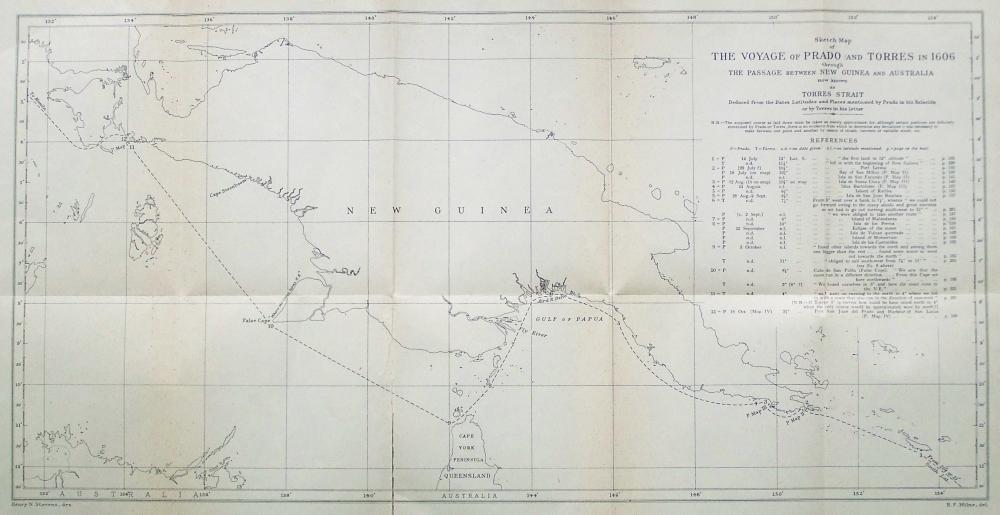
As to what happened to the San Pedrico and the launch after the departure of Quiros, and how the voyage was continued and completed, very little has been known up to the present. All the evidence hitherto available was derived from a letter which Torres wrote to the King of Spain from Manila in July 1607, and from four maps made by Prado in 1606 now preserved at Simancas, or from two very short letters which Prado sent home to the King from Goa in 1613(*). From Torres' letter we learn that they remained in the bay for fifteen days, when finding Quiros did not return "we took Your Majesty's orders and held a consultation with the officers of the launch. It was determined that we should fulfil them"(2). Accordingly they proceeded as far south as 21° S. Lat. in search of new lands, and not finding any, they followed their instructions and turned to the north, shaping their course for Manila. They were evidently intending to proceed on the direct known course to the north of New Guinea, but Torres tells us in his letter that after falling in "with the beginning of New Guinea,...I could not weather the east point, so I coasted along to the westward on the south side"(**), that is to say on the side directly opposite to Australia. To that lucky chance of failing to weather the east point of New Guinea we owe the unconscious discovery of Australia. Torres of course had no idea of the importance of the discoveries which were being made to the south of New Guinea, for he devotes only a few lines to the mention of this part of the voyage. But from the very meagre details he does give, many geographers are agreed in supposing that in addition to discovering "islands without number" in the strait, he must actually have sighted the great continent of Australia, having presumably mistaken the narrow northern point of Cape York for a large island. Torres definitely mentions that before they could get clear of the shoals they sailed as far south as 11° S. Lat., which is considerably farther to the south than the latitude of Cape York. All doubts and suppositions on these points are resolved by the lengthy details given in Prado's Relación.
[* Vide Appendix II.]
[** Burney-Markham version.]
{Page 24}
(Continued from page 15.)
An account has already been given in the editor's preface as to how this most important manuscript was recovered after having been lost to sight for more than three hundred years, and how it was identified as being wholly in the handwriting of Prado.
The manuscript is foolscap folio in size and consists of sixteen leaves, very closely and neatly written on both sides, making thirty-two pages in all, containing in the Spanish about nineteen thousand words, equivalent in the English translation to about twenty-two thousand seven hundred and fifty words. In condition it is clean and sound, doubtless due to the fact that it has been preserved with numerous other Spanish manuscripts stitched together and bound in a limp vellum cover, perhaps two hundred years or more ago.
As the present volume must necessarily be largely supplementary to the Voyages of Quiros edited by the late Sir Clements Markham in 1904(*), it has been thought desirable to print it in the same size (viz. demy 8vo). To reproduce the entire manuscript in facsimile in the size of the original (foolscap folio) would defeat that object, and would moreover add greatly to the cost of the volume. Furthermore the manuscript, although very clear and legible, is somewhat difficult to read owing to the spelling of the period, and the numerous contractions used. Hence it has been thought best to print it in the form of a transliteration into modern Spanish with the contractions expanded. The first and last pages of the manuscript are reproduced in reduced facsimile as illustrative plates (Vide pp. 85 and 206).
[* Vide footnote, p. 10.]
{Page 25}
The title-heading(*) (translated) reads as follows:
JESUS MARIA JOSEPH
Summary relation of the discovery begun by Pero Fernandez de Quiros, a Portuguese, in the Southern Sea in the southern parts up to the island of Irenei called by him the Great Astrialia of the Holy Spirit, and completed for him by Captain Don Diego de Prado, now a monk of our father Saint Basil the Great of Madrid, with the help of Captain Luis Baes de Torres in the ship San Pedrico in the year 1607(**) up to the city of Manila on the 22 of May of the said year, to the honour and glory of the omnipotent God, Amen.
[* Vide the facsimile on p. 85.]
[** Cf. p. 42 and facsimile on p. 85.]
Just above Prado's title-heading the following inscription in Spanish (but here translated) appears in a later hand(*), doubtless written before the volume was bound. It was evidently intended as a filing-heading, after the manner of an ordinary endorsement.
[* Vide the facsimile on p. 85.]
Discovery made by Pero Fernandez de Quiros in the Southern land, and completed for him by Don Diego de Prado who was afterwards a monk of the Order of S. Basil.
About one-quarter of the manuscript relates to events which took place whilst Prado was still associated with Quiros as captain in the San Pedro y San Pablo. A small portion describes what happened between the time of Prado's transference to the San Pedrico about the middle of April 1606, and the separation of the ships on June 11. The remainder gives a detailed account of his continuation of the voyage to Manila in company with Torres. It will thus be seen that about three-quarters of the whole manuscript is virgin material.
{Page 26}
The geographical record given by Prado in the first part of the manuscript, of the discoveries made prior to the separation of the ships, covers much the same ground as the existing narratives inspired by Quiros. But Prado's Relación was written from an entirely independent point of view, hence the details he gives of certain events vary considerably from the other accounts. The chief interest of his graphic narrative, down to the time of the separation of the ships, lies, however, in the lengthy personal details he gives of the character and actions of Quiros. Although his statements may not be considered absolutely impartial, it must be admitted that they are apparently written in good faith and in straightforward and definite terms. Moreover they confirm in a remarkable manner certain other contemporary independent documents which undoubtedly cast grave doubts on the bona fides of Quiros. (Cf. the Letter of Torres, the Memorial of Dr Juan Luis Arias, the Memorial of Don Fernando de Castro, etc., etc., all printed by Markham.)
Notwithstanding that Markham refers to all these various documents, he sums up Quiros as a very skilful pilot--a great navigator and idealist, but unfortunate in his enterprises in not meeting with due recognition and recompense for his great services--and a hardly used man, worn out by years of wearisome and unsuccessful solicitation at the Court of Spain for further employment as commander of another expedition to attempt further discoveries in the Southern Seas. Entirely new and important information explaining the reasons why Quiros met with such ill success at Court after his return from his expedition of 1606, has come to hand in a Report of the Council of State to the King in 1608, a copy of which has just (July 1929) been secured from Spain and which is fully described on pp. 55-6 infra.
There has always been much uncertainty as to the reasons which caused Quiros so suddenly to abandon his expedition and return to America, leaving the other two ships to continue the voyage. A document preserved in the British Museum, the Memorial of Dr Juan Luis Arias to Philip III King of Spain, written about 1615, states the case most concisely even at that early date. (Vide Markham, p. 525.)
{Page 27}
For certain reasons (they ought to have been very weighty) which hitherto have not been ascertained with entire certainty, Pedro Fernandez de Quiros left the Almiranta [i.e. Torres' ship] and the launch in the said bay [i.e. the Bay of St Philip and St James] and himself sailed with his ship the Capitana for Mexico, &c., &c.
This doubt existing as early as 1615 has never been fully resolved until the recent recovery of Prado's manuscript. Markham, evidently basing his introductory story on the existing narratives, merely implies that the breaking away of Quiros' ship was unavoidable, for the reason that Quiros himself was too ill to come on deck and that the pilots, losing their heads in the confusion caused by the storm, eventually stood out to sea before the wind and, being unable to regain the Bay, decided to return to America(*). Torres in his letter to the King from Manila, July 12, 1607, tells a very different tale(**), as also does Prado in his letter to Antonio de Arostegui, the King's secretary, dated from Goa, December 24, 1613(***). In this letter Prado definitely states that the crew mutinied and carried off the ship with Quiros as prisoner. Markham, commenting on the fact that Quiros does not mention any actual mutiny, merely states that "his enemy Prado y Tovar, who must have got his information from the men who remained at Mexico, and perhaps afterwards found their way to the Philippines, makes the assertion ". But Markham does not seem to attach the slightest credence to this assertion of Prado, although in the same letter he (Prado) speaks of the incipient mutiny whilst he was still on board the Capitana with Quiros. Here are Prado's own words: "I knew what took place on board, took part in it, and as it was not in conformity with the good of the service of Your Majesty I could not stay. So I disembarked at Taumaco and went to the Almiranta [i.e. Torres' ship] where I was well received".
[* Vide Markham, pp. xxv and xxvi.]
[** Vide Appendix I]
[*** Vide Appendix II]
{Page 28}
Here then is the reason for finding Prado associated with Torres in the second ship. In the newly discovered manuscript Prado relates this incident in detail, telling how he and Torres had continually remonstrated with Quiros about his actions and warned him of the imminent mutiny, until at last he (Prado) was so disgusted at Quiros' dilatoriness and inattention to the orders he had received for the King's service that he craved permission, which was granted, to remove to Torres' ship. The transference took place about the middle of April 1606.
Markham seems to have formed a most unfavourable opinion of the character of Prado, in fact he goes so far as to accuse him of "stirring up mutiny and disaffection on board" (Markham, p. xxii). Again on p. xxix he describes him as a mutinous officer who was "sent on board the Almiranta" by Quiros. On pp. xxxii and xxxiii, when mentioning the letters and maps sent home by Prado from Goa, Markham returns to the attack and describes him as "the malignant enemy of Quiros" and further states that "the abuse of Quiros by this insubordinate officer can be taken for what it is worth".
It is submitted that from the evidence existing at the time, all of which he exhibits in his book, Markham does not seem to have had any adequate foundation for such very severe condemnation. He appears to have erroneously assumed that Prado must have been a mutinous officer simply because, by his own statement, he left the Capitana and went to the Almiranta, but it makes all the difference in the world whether he transferred himself by permission or was "sent on board the Almiranta" by Quiros, as Markham definitely states. In the quotation from his letter given above, Prado, after referring to the mutiny, simply says: "So I disembarked at Taumaco and went to the Almiranta where I was well received ". The new Relación explains in full the circumstances of the transference and the reasons for it, and clearly shows that Prado was anything but a mutinous officer. Instead of stirring up mutiny he seems to have done his best to quell it. Here is the story told in his own words:
{Page 29}
Captain Don Diego de Prado knowing for certain that the men of the Capitana were going to mutiny informed the said Quiros by way of confession through the Father Commissary of the Franciscans, who told the said Don Diego that he also knew it and had informed him [i.e. Quiros] and would do so again, but the said Quiros took no notice of it, so the said Don Diego, seeing the little remedy that was to be expected, asked leave of the said Quiros to pass to the Almiranta...he granted it to get rid of the bother...The said Don Diego knew who were the mutineers and how they wanted him for head, but he did not want to mix in such conflicts and lose the honour which he had gained in the service of his Majesty, so he at once shifted his things to the Almiranta, whereat the Captain thereof [i.e. Torres] was very pleased. The next day the surgeon did the same. [Vide pp. 112-13.]
Prado's narrative is so circumstantial and clear throughout that it may be said to carry conviction with it, and its truth is largely corroborated by the aforementioned existing independent evidence. Surely, as no adequate reason has ever been given for the defection of Quiros at Espiritu Santo, no one who reads Prado's account (as quoted above) of the imminent mutiny at the time he left the Capitana, can have any doubt that the mutineers carried off the ship at the time of the storm on June 11 and compelled Quiros to return to America. This view is amply confirmed by the account given by Prado near the end of his Relación, derived from information he received after he reached Manila from some sailors who had been in the Capitana at the time and had returned with Quiros to America and had since voyaged to the Philippines. (Vide pp. 194-7.)
Little has hitherto been known of Prado beyond the very brief mention made of him in the narratives of Belmonte Bermudez, Leza and Torquemada. But even before the recovery of Prado's Relación, his two short letters sent home from Goa in 1613, addressed to King Philip III and to the King's secretary, Antonio de Arostegui, make very grave charges against the character and actions of Quiros.
{Page 30} Markham seems to have regarded these letters merely as the ex parte abusive statements of a mutinous officer, and yet he admits the great interest and value of the four maps made by Prado in 1606. In his detailed account of them Markham states (pp. 469-73) that "all the maps are signed by Diego de Prado y Tovar, who thus claims to be their author. The surveys were no doubt made by Torres himself or by his Chief Pilot Fuentidueñas". Markham further testifies to the accuracy of these maps as proved by comparison with the surveys of modern times. Now if the accuracy of the maps is thus proved and admitted, what reason can there be for doubting the truth and accuracy of the descriptive legends upon them(*) which are largely amplified in detail by the new manuscript Many of the places marked on the maps are mentioned in the Relaciòn, as hereinafter noted. Again, if the accuracy of the maps and their descriptions is admitted, what reason can there be for questioning the truth of the other statements about Quiros made by Prado in his letters to the King, the details of which are fully set forth in the new manuscript? When we remember that Quiros returned direct to Mexico after the separation of the ships instead of proceeding to Manila (thereby entirely ignoring the orders and instructions he had himself promulgated for the conduct of the expedition in such an event, and also contravening the sealed orders given by the Viceroy of Peru for the conduct of the expedition in case of the separation of the ships (Vide infra, p. 34), what reason can there he for doubting the very circumstantial account given by Prado as to what took place, especially when it is corroborated by the independent statements of Torres, Arias, Castro, Iturbe and others? (Cf. Markham, pp. 525, 508, xxix, xxxiii, etc., etc.)
[* Vide Appendix III; also Markham, pp. 470-3.]
{Page 31}
The truth and accuracy of the statements made by Prado being once established, it is obvious that an entirely different estimate must henceforth be formed of the character of Quiros, whose name can no longer be held to merit the exalted position it now occupies in the annals of the world's greatest pioneer discoverers. On the other hand Don Diego de Prado y Tovar becomes revealed to the world as a great captain and discoverer, whose name has never yet received due recognition. He must in future be placed in the ranks of the great navigators and his name, henceforth freed from obloquy, coupled with that of Torres as joint discoverer of Australia.
The character of Prado has been assailed by other writers since Markham's time. For instance the late Mr Robert Logan Jack in his extensive work Northmost Australia, published in 1921(*), with no more evidence than was possessed by Markham in 1904, was yet able to heap additional discredit on Prado. It is the old story of giving a dog an ill name, when each succeeding writer takes for granted the accuracy of the deductions of his predecessors, and enlarges upon them without making any attempt at an independent re-examination of the basic facts.
[* Jack, Robert Logan. Northmost Australia. Three centuries of exploration, discovery and adventure in and around the Cape York Peninsula Queensland. 2 vols. Royal 8vo. London, 1921.]
Here is what Jack says of Prado:
The insubordination on the flagship had to be dealt with. The ringleader was the Chief Pilot, or Captain, Juan Ochoa de Bilbaho, for whom Quiros considered that a sufficient punishment was to be relieved of his office and sent on board the Almarinta...A bitterly spiteful enemy of Quiros, and necessarily a supporter of the disrated Captain, was Diego de Prado y Tobar, who according to his own account, voluntarily accompanied Ochoa and boarded the Almiranta at Toumaco. In allowing an officer of the flagship to desert openly and to side with a degraded malcontent, it seems to me that Quiros displayed a weakness which was most reprehensible...The assertion [by Prado] that he was Captain is sheer impudence, as there can be no question that the Captain was Ochoa. Prado was perhaps a "mate" of some sort. [Jack, p. 13.]
In another place (p. 15), Jack speaks of "the outrageous conduct of Prado".
{Page 32}
Here is manufactured history with a vengeance. Let us analyse it. The reader is invited to collate these wild extravagant stories of Jack and the somewhat milder censures of Markham, with the letters of Prado and Torres printed in the Appendix (which constitute all the evidence which either of those writers had to go upon), and then to form his own opinion as to whether or not their aspersions are justified. Not a word of discredit is thrown on Prado in the narratives of Belmonte Bermudez, Leza and Torquemada. As far as the writer is able to judge there is no foundation whatever for Jack's statement that Prado was a supporter of the "disrated Captain Ochoa", or that he "according to his own account voluntarily accompanied Ochoa and boarded the Almiranta". Prado made no such statement, for Ochoa is not even mentioned in either of his two letters. Neither is there any ground for the charge that Prado deserted openly, nor is there any evidence that Ochoa was captain. Prado was certainly captain, as he himself states, whilst Ochoa was merely chief pilot, and is frequently mentioned as such in the existing narratives. In confirmation we now have the definite statement in the certificate appended to Prado's Relacidn where Juan Ochoa de Vilbao is described as "chief pilot of this expedition ". (Vide infra, p. 37. Cf. also p. 89.)
Prado's newly recovered Relación definitely refutes all the obloquy cast upon his name and further shows that his two letters from Goa were accurate in their statements. It is therefore now evident that the tenor of those letters was misinterpreted by historians, who, preferring to believe the narratives of the associates of Quiros, necessarily discredited Prado, as both versions could not be true.
{Page 33}
The writer, standing in the position of sponsor, as it were, for the newly discovered Relación, has felt it his bounden duty to employ every possible means of refuting absolutely the calumnies hitherto showered upon Prado. What credence could possibly be claimed even for such a wonderful narrative as the Relación whilst its author was held to be the disreputable person characterised by modern historians?
Fortunately, from the internal evidence of the new manuscript and from independent genealogical and heraldic researches, a very different estimate can now be formed of the true character of this much-maligned man. Captain Don Diego de Prado y Tovar, to give him his full title, belonged to one of the noblest families of Madrid, and was a Knight of Calatrava, one of the oldest and most distinguished of Spanish Orders of Chivalry, founded in 1158. He was undoubtedly the most important and distinguished person in the whole expedition, far above Quiros and all the other officers in rank and social position, and was actually nominated by the Viceroy of Peru in his sealed orders to succeed to the chief command in case of anything happening to Quiros (Vide infra, p. 34). He evidently had a love for adventure, for he mentions that he had previously served the King in the East and West Indies. With such a record, surely he would have been the very last person to have stirred up mutiny as Markham suggests. Moreover it is a significant fact that in neither of the existing narratives is the slightest complaint or censure of his behaviour expressed. His position at the commencement of the expedition was captain of the San Pedro y San Pablo, that is to say he was second in command to Quiros himself, whilst Torres was captain in a similar position in the second ship, the San Pedrico. Prado's disagreements with Quiros, and the reasons which caused him to transfer to the San Pedrico, have already been explained.
{Page 34}
It must now be recorded how Prado came to succeed to the supreme command over the head of Torres, after the separation of the ships on June 11, 1606, a fact entirely new to history. Prado tells us that Torres, after searching in vain for the San Pedro y San Pablo, held a council, when it was decided to wait in the Bay of St Philip and St lames until June 20, to see if Quiros returned or whether any traces of the wreck of his ship could be found. Meanwhile they searched the coast in both directions, but found nothing. The sequel is best told in Prado's own words.
On the 25th [June], S. John's Day, Luis Baes [i.e. Torres] again summoned a council and produced a closed and sealed paper, and said it was from the Viceroy of Peru; in substance it contained and said that in case any of the ships should go astray they should make every effort to go up to 20° of S. altitude and see if there was any land in that region, and not finding itshould go to the city of Manila and wait there for four months for the other ships, as they also carried the same orders; and in case Pedro Fernandez de Quiros should fail they were to take Captain Don Diego de Prado for chief in order that he might direct that voyage...The said Don Diego accepted the charge as committed to him, and thenceforth executed his office [etc.]. [Vide infra, pp. 130-3.]
These sealed orders are absolutely in accordance with the King's mandate to the Viceroy dated May 9, 1603, as given in Quiros' own narrative. (Cf. Markham, pp. 171-2.) Torres himself makes mention of these orders in a somewhat indefinite passage in his Letter, the exact meaning of which has not hitherto been fully realised, because it was not known to what orders he was referring. Speaking of what occurred in the great bay in the island of Espiritu Santo after the departure of Quiros, Torres says:
{Page 35}
I had to return to the Bay to see if perchance they [i.e. Quiros and his men] had returned to it, all this I did for further loyalty in this Bay, and I waited fifteen days for them at the end of which I brought forth Your Majesty's orders and calling a council jointly with the officers of the Launch, it was agreed that we should fulfil them, though against the inclination of many, I might say of the majority, but my condition(*), was different from that of Captain Pero Fernandez de Quiros(**).
[* Condicion in Spanish has the same variety of meanings as in English.]
[** This translation is from the copy of the Spanish text recently obtained from Madrid (Vide pp. 54-5) and printed herewith in Appendix I. It varies considerably from the versions given by Markham and others, with which it should be compared (Vide M. p. 462).]
But Prado, although succeeding to the supreme command, seems to have remained on the best of terms with Torres, and does not appear to have interfered with him in his nautical captaincy. That is to say Prado was now the chief of the expedition, whilst Torres was his captain, exactly in the same position as Prado occupied when he was captain under Quiros, the former chief. This is evident from the fact that on Prado's maps, which bear his name as maker, all the discoveries laid down are attributed to Torres. (Vide the facsimiles and the legends in the Appendix.) In this new manuscript, when speaking of nautical matters, Prado usually uses the plural "we discovered", "we drew out", "we coasted along", etc., etc., but when naming places he generally speaks in the singular, " I gave the island the name of", etc., etc., and when taking possession of any lands in the name of the King of Spain he uses the formula, "I Don Diego de Prado Captain and Chief take possession", etc., etc.
Although it has hitherto been supposed that Torres was in command of the voyage after the separation of the ships, it must be admitted (now that the circumstances of the failure of Quiros have become known) that Prado's succession to the chief command follows the customary course. For Prado was originally the captain of the senior ship and would have been entitled to the chief command by seniority, even if there had been no sealed orders from the Viceroy.
{Page 36}
Throughout his narrative it appears that Prado acted as an honourable man, always carrying out his orders with the sole object of serving faithfully his lord the King. Even after complaining of the conduct of Quiros he was still loyal to him, for, as may be seen from the title-heading of his Relación, he states that it is a "summary relation of the discovery begun by...Quiros...and completed for him by Captain Don Diego de Prado...with the help of Captain Luis Baes de Torres...". He was no egotist, and beyond stating the actual details of the events in which he was concerned, he takes to himself no credit whatsoever for the important discoveries made.
Before giving an abstract of the contents of the Relaciòn it may be as well to describe it more fully in order to indicate that it is in the handwriting of Prado, and to endeavour to show when and for what purpose it was written.
There is no doubt whatever that Prado's four maps of 1606, now believed to be preserved at Simancas, were the work of Prado himself, for they all bear an inscription to that effect, and the handwriting of the place-names on them is identical with that of the new manuscript, as may be seen by comparison (Vide facsimiles in the Appendix). Furthermore the signatures agree, save that the one on the fourth map is written in full, "Don Diego de Prado y Tovar", whereas in the Relación it appears in the abbreviated form "Don Diego de Prado ". But in Spanish documents, the rubric, or complicated flourish which was nearly always appended to signatures, is considered even more characteristic than the signature itself. In the present case the rubric places the question of the identity of the handwriting beyond the possibility of doubt, for the two agree absolutely, although in the case of the map it follows the name "Tovar", whilst in the manuscript it is appended to "Prado".
{Page 37}
The following most important certificate is appended to the Relación immediately below Prado's signature:
Luis Baes de Torres, Captain of the Almiranta called San Pedrico; Gaspar de Gaya, master; Juan Bernardo Fontidueña, pilot; Juan Ochoa de Vilbao, who was chief pilot of this expedition and Francisco Rodrigues de Mazagaon notary thereof, certify that at the instance of the Captain and Commander Don Diego de Prado we have seen this account which he made of this discovery from the port of the Callao of Lima to that of Cabite of Manila, and it is accurate and true, and we hold it for such because we have compared it with others which we ourselves had, and in order that at any time he may be able to send or give it to His Majesty or to the Lords of his Royal Council of the Indies and they may give to it the credit it deserves, we sign it with our hands and names and it is dated in Manila of the Philippines on the 6th day of the month of June of the year one thousand six hundred and eight. Luis Baes de Torres. Gaspar de Gaya. Juan Bernardo Fontidueña. Juan Ochoa de Vilbao Francisco Rodriguez de Mazagaon, Notary of the Ship. [Vide facsimile, p. 206.]
From the fact that the five signatures to this certificate are in the handwriting of Prado, it is clear that the whole manuscript is his own holograph duplicate, but we have no knowledge of what became of the original, for no such document is now known to exist. Hence this holograph duplicate has the same importance as the lost original by reason of the absolutely virgin historical material it contains.
If the original was ever sent home, it has been lost, but it is extremely doubtful whether it was ever sent. It seems more probable that Prado carried it with him when he returned home. His two letters from Goa, dated December 24 and 25, 1613, throw a little light on the subject (Vide Appendix II).
The letter of December 24 shows conclusively that Prado sent home a map, for he says:
{Page 38}
I send to your Majesty the Map of the discovery which Luis Vaez de Torres, Captain of the Almiranta of Pedro Fernandez de Quiros made...The discovery is of the island called by us the "Magna Margarita"(*).
[* New Guinea.]
In the letter of December 25, Prado writes:
I send to Your Majesty the discovery of the great Margarita, Southern Land, made by Luis Vaez de Torres, Admiral of Pedro Fernandez de Quiros, for it is full time that it reached the hands of Your Majesty.
It seems impossible to determine definitely whether the word "discovery" in the second letter was intended to mean "the Map of the discovery" as mentioned in the first letter, or whether the Relación (as an account of the discovery) was referred to. Probably Prado was speaking of the map, for in the same letter he states that when he had reached the Court and had kissed the hand of the King he would "give a full and particular account". He would hardly have written to that effect if he was sending on the Relación with the map. Would he not more probably have said "a fuller account" or "a further account"? The inference appears to be that he carried his Relaciòn with him, and that it was the "full and particular account" he proposed to give.
Markham (p. xxvii) definitely states that "in 1613 Diego de Prado v Tovar sent home four maps from Goa which throw considerable light on the course of Torres's ship". But it is evident from the letters quoted above that Prado only sent home one map, which from the wording of his letter of December 24 must have been a route map, probably of the whole voyage including New Guinea, for he definitely says, "Your Majesty will see by the said Map that which Pedro Fernandez de Quiros, the impostor, discovered were some reefs and small islands, for his crew mutinied in the bay of the island of Espiritu Santo". The four Prado Maps as we know them to-day are confined to four separate places(*), but the route map such as referred to by Prado in his letter quoted above and also mentioned at the end of his Relación has not as yet been re-discovered in the Spanish archives, although diligent search has been made for it(**).
[* Vide facsimiles at the end.]
[** Vide p. 40.]
{Page 39}
From the recently recovered Report of the Council of State of September 25, 1608(*), it appears that Markham(**) was mistaken in supposing that the four maps made by Prado in 1606 were only sent home by him in his letters of December 1613, for five maps were enclosed in the letter of Torres of 1607 as mentioned in the said Report. These maps had reached Spain more than five years before the date of Prado's letters. It is not of course definitely known that four out of the five maps sent home by Torres in 1607, as mentioned in the Report, were the actual four maps of Prado as we know them to-day, but it is very probable that they were. Neither is it known that the fifth one was the missing route map, but here again the probability is very strong. It is also impossible to say whether the map sent home by Prado in 1613 was a copy of one of the five enclosed in the letter of Torres of I 607, or even whether it was identical with the one referred to at the end of his Relación(***). The presumption is that it was a fresh map of the route, for (if it was a map and not the Relación that Prado was referring to in his letter of December 25, 1613) he would hardly have written "it is full time that it reached the hands of Your Majesty", if it had been a copy of a map sent home in 1607, which he had no reason to suppose had not already reached the King. All this is a matter of conjecture, for the Report of September 1608 merely states:
[* M. p. xxvii.]
[** Vide p. 26 ante and pp. 55-6 infra and Appendix I.]
[*** vide p. 40.]
Some days ago there was laid before the Council a letter from Louis Vaez de Torres...and likewise were exhibited five maps which he sent of some ports and islands where he landed.
{Page 40}
The aforementioned certificate of Torres and others(*) near the end of Prado's Relación is dated June 6, 1608, from which it is clear that the route map mentioned immediately after the certificate could not have been of an earlier date, and hence could not have been one of the actual five sent home by Torres in 1607, unless the Relación map was merely a copy. The route map is thus referred to by Prado in the final paragraph of the Relación:
The black line which is marked on the map and begins from the port of the Callao of Lima and ends in that of Cabite of Manilla, represents and shows the route the ships made throughout the navigation, and the region and places they passed until they reached the said port of Cabite of Manilla.
[* Vide p. 37 ante and facsimile, p. 206 infra.]
It is possible that the fifth map mentioned in the Report of the Council in 1608 may have been another local map and not a route map at all. The Report merely speaks of five maps of "some ports and islands" but makes no mention whatever of any route map of the whole voyage. Presumably the route map was prepared by Prado for his original Relaciòn, but like the Relación itself it has never come to light. It is greatly to be regretted that no duplicate route map was found with the present duplicate Relación. Unfortunately no route map of the voyage, from whatever source, is now known to exist, but Prado's graphic description, as quoted above, would enable it to be instantly recognised if it should ever be found. Here then is a chance for some indefatigable searcher of records. If that route map still exists, he who recovers it after three hundred years will restore to the world a document of supreme importance, second only to the chart of Juan de la Cosa, the pilot of Columbus.
{Page 41}
Reverting once more to the Relación itself, it appears at first sight that this duplicate was made at Manila in 1608, at the date of the signing of the certificate. But a careful perusal indicates that it could not have been made until after Prado had returned to Madrid. Certain references to subsequent events make this evident. For instance, in the title Prado describes himself as "now a monk of our father Saint Basil the Great of Madrid ". As this was a new Order founded only in 1610 he could not have belonged to it until after his return home. Exactly when he did return home is uncertain, but from his letters, written from Goa in December 1613, we learn that he had been delayed by the Governor of Manila who would not give him proper despatch, but that he was now leaving Goa "for Ormuz on the 8th of February of next year [i.e. 1614]...and thence by land with the caravan of the Venetian merchants, journeying little by little to Aleppo, and thence to Venice and other places until I reach this Court, kiss the hand of your Majesty and give a full and particular account"(*). From this passage it seems likely that he was carrying with him the original Relación with the certificate attached. From the length of the journey and the delays of transport he could hardly have reached Madrid until late in 1614 or early in 1615.
[* Vide Appendix II.]
It seems probable that Quiros had to a certain extent made good at Court in the meantime, for he had been despatched to Peru(*) with promises of further employment before Prado could have reached Madrid with his Relaciòn. They could hardly have met, for Quiros is reported to have died at Panama in 1614(**), and it would have taken him some time to have journeyed there from Madrid. Markham on pp. xxxiv-v discusses the action taken at the Court of Spain with regard to Quiros, but some fresh valuable information on this point will be found in the aforesaid Report of the Council of State of September 1608, as fully detailed infra at pp. 55-6.
[* Vide p. 56.]
[** Markham, p. 517. Cf. p. 57 infra.]
{Page 42}
We have no knowledge of what happened after Prado arrived in Madrid. As his original Relación is not known to exist we cannot say in what state it reached the King, if at all. If it agreed with the present manuscript, Prado must have made a fresh fair copy, for, as has already been said, this duplicate contains some references to events later than the date of the certificate. For instance, on the second page Prado describes his banner bearing the Cross of Calatrava, which was hoisted with the banners of the other captains when the expedition sailed from Callao in December 1605, and goes on to say:
After the voyage, when the aforesaid reached the island of Malta and the new city of Valetta, he had some roman characters written round it saying, speaking with the Cross, With thee I have gone round the whole world and have discovered new southern kingdoms, Lippis, Canais Suleis and Hobaniaños for the great Philip, King of the Spains, and it is now in the Chapel of Nuestra Señora de la Buena Ventura in the Church of S. Basil the Great [etc.]. [Vide infra, pp. 90--1 .]
On the first page of the manuscript, in the title-heading, the date 1607 has been altered to 1608 by a later hand, as may be seen by the difference in the colour of the ink. The date 1607 is of course correct, and the alteration was probably made to accord with the date of the certificate at the end. There is a curious error made by Prado himself on p. 29 of the manuscript where he says (speaking of his arrival at Manila on May 22): "with this our expedition ended, which lasted seventeen months from the 21st of December 1606 to the twenty-second of May 1608". This is clearly a clerical error, for it is well known that the expedition sailed from Callao on December 21, 1605, and reached Manila May 22, 1607 (cf. Markham, pp. xxii, 180, 181, 323, 466). Torres' letter to the King, dated from Manila July 12, 1607, states that it was two months since his arrival. (Vide Appendix I.)
{Page 43}
A similar clerical error, 1606 for 1605, occurs in the side-note on the first page of the manuscript. But these errors are important as showing conclusively that the manuscript in its present form could not have been written in 1608, the date of the certificate. Had it been written at that time, such errors would have been impossible, but a confusion of dates is quite probable after an interval of seven years. Internal evidence proves without doubt that these errors are purely clerical. The certificate is correctly dated June 6, 1608, and near the end of the manuscript(*) there is an account of some of Quiros' old crew having arrived at Manila from Mexico "at the beginning of June", clearly meaning June of the same year as the arrival of Prado, which in the preceding sentences he states was on May 22. This from other sources has been shown to be 1607. No one would speak of the "beginning of June" in a document certified on June 6, if it were in the same year. The certificate must clearly have been dated a year after the return of the expedition to Manila, and indicates that Prado and Torres and those who signed it were still there in June 1608.
[* Vide p. 193.]
After careful consideration of all these facts the only logical conclusion seems to be, that this manuscript is a fair copy in Prado's own handwriting made (c. 1615) after his return to Madrid, embodying a copy of the original certificate of 1608 as to the truth of the actual events of the great voyage, but interpolating a few personal details of occurrences after he left Manila.
The enormous importance to geographic history of the new manuscript, by reason of the mass of entirely new and unsuspected information it contains, may readily be perceived from the following epitome and notes(*). From the commencement of the voyage on December 21, 1605, to June 11, 1606, when the ships parted company, Prado's account of the main events connected with the discoveries made down to that time is much the same as that given in the three existing Narratives as printed by Markham, but there are naturally considerable variations in the details. Whilst Prado omits many things mentioned by the others, he gives much new or additional information. This section of the Relación is particularly interesting and important by reason of the entirely unsuspected light it sheds on the personal character of Quiros and his wilful conduct, which caused Prado to transfer himself to Torres' ship and led up to the subsequent mutiny and the parting of the ships.
[* Vide pp. 44-5 and 71-6.]
{Page 44}
Abstract of the new information contained in the Relación, up to the separation of the ships. [Vide infra, pp. 93-129.]
Prado informs Quiros of certain signs he had observed at 26° S. Lat. indicating large land ahead--Conference of Pilots and general agreement as to the signs of land and resolution to proceed in the direction indicated--Quiros gives secret orders to change the course at midnight to N.W., influenced thereto by a relative on board and by the Chief Pilot who wished to hasten the voyage to Manila--Account of the Chief Pilot Juan Ochoa de Bilbao--Unavailing remonstrance of Prado with Quiros for altering the course and not continuing to sail up to 30° S. Latitude according to the Viceroy's orders, and in conformity with their own oaths--Enmity of the crew against Quiros and incipient mutiny by reason of the change of course, and their discovery that he and his friend (Sojo) had secretly shipped 200 jars of wine for sale at Manila in place of 200 jars of water, the shortage of which was already causing discontent--Prado's further remonstrances with Quiros as to his behaviour and neglect of the Viceroy's orders--Consequent ill-will of Quiros and threat to put Prado ashore on a desert island, and Prado's defiance thereat--Quiros' attempt to placate the crew by promises of rich rewards to come--Irony of the crew in consequence of their lack of faith in such evidently idle promises--Prado informs Quiros through the Father Confessor of the imminent mutiny of the crew, but Quiros takes no notice--The mutinous crew want Prado for head, but he, not wishing to mix in such conflicts and lose the honour which he had gained in the service of his Majesty, obtains leave of Quiros to transfer himself to the Almiranta [i.e. Torres' ship the San Pedrico]--Prado's transference with all his rations--Alonso Sanchez the surgeon also transfers the next day--Quiros orders the Chief Pilot Juan Ochoa de Vilbao to be seized and taken to the Almiranta with verbal orders to Torres that he should be garrotted at once and cast into the sea after confession--Prado's advice to Torres not to execute this order unless given in writing--Quiros' refusal to give the order in writing--Strong personal reasons for Quiros' desire to get rid of Ochoa--Torres' and Prado's further remonstrances with Quiros as to his actions--Landing in the Bay of St Philip and St James--Institution of the Order of the Holy Ghost and investiture of officers therein--Wild scheme to build the City of New Jerusalem and appointment of Officers to govern the same--Island of Ireney called by Quiros the great Australia of the Holy Spirit--Possession taken in the King's name--Prado's objection to Quiros' form of declaration on that occasion and public correction of the same and retort by Quiros--Details of the parting of the ships on June 11 during a gale--Search made for the Capitana without result and no traces of wreck found--Prado's conviction that the crew had at last mutinied and carried off the ship, confirmed shortly after he reached Manila by the story told him by some of the sailors who had been in the ship with Quiros and who had just arrived from Mexico.
[Abstract continued on p. 71]
{Page 45}
From this point onwards the Relación deals entirely with the continuation of the voyage from the island of Espiritu Santo until the expedition reached Manila, that is to say from June 11, 1606, to May 22, 1607. Except from the short letters of Torres and Prado and Prado's maps preserved at Simancas, practically nothing has hitherto been known of this most momentous voyage. The recovery of this manuscript, giving the first detailed account of one of the most remarkable voyages ever made in the Age of Discovery, may therefore well be described as of inestimable value, and may be regarded as the very corner-stone of Australian pioneer history.
Before continuing the Abstract it may be as well here to comment on and brush aside some of the erroneous deductions which modern historians appear to have drawn from the aforesaid letters of Torres and Prado and the Prado Maps.
[Continued pp. 69-76.]
{Page 46}
One of the latest writers, Mr R. Logan Jack, in his extensive work Northmost Australia(*), devotes no less than thirteen pages to an account of the voyage of Torres. His aspersions on the character of Prado have already been shown to be not only entirely unwarranted but purely imaginary(**), and some of his comments on the inaccuracies (as he supposes) in Torres' own account of his voyage seem to be equally unreliable. Let us examine them. Wytfliet's definite mention of a narrow strait between New Guinea and Terra Australis has already been discussed(***), and the suggestion made that it was at the best merely suppo- sitional. It is of course quite possible that Torres was acquainted with the rumour that there was such a passage, but, as will be seen, he was certainly not making for it on his voyage to Manila. Nevertheless, on p. 21 of his book, Jack states that everything points to the fact that Torres was making "for a passage regarding which he was already in possession of some information ". On p. 18 he says that Torres "fell in with the beginning of New Guinea", and after coasting to the west for five days landed on what he named Tiera de Buenaventura on July 18, 1606. But this is no evidence that Torres knew of the strait and was making for it. The contrary is easily proved, for it is clear that Torres was planning to go to the north of New Guinea. His standing orders from Quiros (as printed by Markham, pp. 183-91) were that in the event of the separation of the ships they were to rendezvous at the Island of Santa Cruz and wait for each other for three months. If at the end of this time the other ships had not arrived, Torres was to "steer S.W. as far as 20°, thence N.W. to 4° and on that parallel he is to steer west in search of New Guinea; after coasting all along that land he is to proceed to the City of Manila...in 14° N.".
{Page 47}
It is evident from these instructions that Torres could not strike the south side of New Guinea on the parallel of 4° S., for there is no water in that latitude on the south side until towards the western end of the island. Torres himself tells us in his letter that after sailing to the south-west as instructed, and having no signs of land that way, "I stood back to the N.W. to 11½° S. Latitude: there we fell in with the beginning of New Guinea...I could not weather the E. point so I coasted along to the westward on the S. side".(****) Two things are evident from the two quotations given above, firstly that Torres was endeavouring to follow his instructions to pass along the north side of New Guinea, and secondly that as he could not weather the east point he was compelled to coast along to the west on the south side. It is thus clearly shown that Jack's inference that Torres was making "for a passage regarding which he was already in possession of some information" cannot be substantiated. Jack actually quotes on p. 18 part of the paragraph in Torres' letter where he says he "fell in with the beginning of New Guinea"(****), but if he had completed it "I could not weather the E. point so I coasted along to the westward on the S. side"(****) it would have been obvious to him that Torres intended to continue to sail to the north-west up to 4°, but was by force of circumstances compelled at 11½° to turn to the west along the south side. Prado's Relación confirms this but gives the latitude as 12°. He tells us that after
directing our route to south west until we reached 20½° of altitude...and having carried out the order, we turned to the north...and although the wind was south east and not much in our favour the Lord God was pleased that at daybreak on the fourteenth of July we should find land [the side-note says "the first land in 12° altitude"], very high, and the coast running very far both ways...We drew out and crowded sail to go eastwards, [i.e. towards the north side of New Guinea], with sunrise the wind blew a stiff breeze so that it was necessary to submit and to go along the coast [i.e. to the west along the south side]. [Vide pp. 132-5.]
[* Cf. footnote, p. 8. ]
[** Vide pp. 31-2 ante.]
[*** Vide pp. 18-20 ante]
[**** Burney-Markham version.]
{Page 48}
On pp. 19 and 21 Jack(*) states that Torres gives impossible latitudes in and about the Gulf of Papua. The present writer (working at first from the translation given by Markham)(**) was himself greatly puzzled by the passage, "We went over it [i.e. a bank] along the coast to 7½° latitude and the end of it is in 5°". But the mystery as to 5° appeared to be solved when an analysis of the context seemed to indicate that 5° was doubtless a misinterpretation by the translator for 5 fathoms. The 9° quoted by Torres is apparently approximately correct, but 7½° is doubtless a trifle too far north, as it would have been right on the coast, or actually inland, as compared with the more precise surveys of modern times. But when we consider the difficulties of accurately determining the latitude during such a tortuous voyage as this, a slight variation is not surprising. A difference of only half a degree [i.e. 8° instead of 7½°] would make Torres' narrative of the voyage in the Gulf of Papua quite feasible. Prado's two maps of this part of the coast confirm the general accuracy of Torres' statements. The question of 5° or 5 fathoms is more fully argued when Captain Bayldon's deductions arc discussed (infra, pp. 51-2).
[* Northmost Australia.]
[** Markham, p. 463.]
As to the 11° mentioned by Torres as his southern limit, Jack (p. 21) thinks this also is impossible "for the reason that it would have brought him well into Queensland". Although it is quite possible for Torres to have reached 11° if he had borne away sufficiently far to the west-south-west after passing through Endeavour Strait, there was no necessity for him to have done so, for he could have turned to the north-west in a lower latitude. It is far more probable that here again there was a slight error in calculating the latitude. A difference of only one-sixth of a degree [i.e. 10° 50' instead of 11°] would have enabled him to pass between Prince of Wales Island and Peak Point, the western extremity of the Cape York Peninsula, and then bear away to the north-west without touching the mainland. The most southerly point of Prince of Wales Island lies in 10° 46', whilst the latitude of Peak Point is 10° 42'. Torres says "there were very large islands and there appeared more to the southward". The "very large islands" may very well have been Horn and Prince of Wales and others in the vicinity, whilst possibly the west coast of the Cape York peninsula may have been mistaken for more islands to the southward. (Cf. p. 73 infra where Prado mentions "other islands towards the North and one bigger than the rest".)
{Page 49}
Jack (p. 21) mentions nine practical passages through the islands and reefs in Torres Strait, and raises the question as to which was used by Torres. He suggests that "the Bligh Channel (10° 20' S.)" most nearly accords with Torres' description of his position when he was able to turn to the north-west. But Jack's mention of the latitude of the Bligh Channel as 10° 20' is obviously an error (probably for 10° 2'), for even on his own map A he shows it in its correct position close to 10°. If Torres actually used the Bligh Channel he would have been practically a whole degree out in his stated latitude, which would seem almost incredible having regard to his general standard of accuracy. Moreover Prado in his Relaciòn mentions that they landed on an island in 10° and afterwards proceeded for many days touching at numerous islands which he describes at some length, before "God was pleased that we should henceforth find more water so that...the wind being a strong breeze we went out towards the north". This description certainly does not accord with Jack's theory that they went through the Bligh Channel, for had they done so their course would have been practically due west until they were actually through that passage. This point is amplified on p. 67. As there is no reason to doubt Torres' bona fides, why not assume that his stated 11° is approximately correct, in which case the only channel he could have passed through would be that now known as Endeavour Strait?
{Page 50}
In the Journal and Proceedings of the Royal Australian Historical Society, vol. xi, Part 3, pp. 158-94 (Sydney 1925), Commander Francis J. Bayldon, F.R.G.S., R.N.R., gives a long technical analysis of the voyage of Torres. This is evidently based on the translation of the letter of Torres of 1607 as printed by Markham, and develops a reasoned argument tending to demonstrate that the stated latitude of 11° S. could not be even approximately correct, and consequently that Torres could not possibly have sighted the mainland of Australia as some writers have held. Bayldon definitely states his opinion that Torres coasted along the south side of New Guinea, keeping as close in shore as the shoals would permit, passing False Cape and continuing to the west and north until he struck the coast at 5° S. in the neighbourhood of Cape Steenboom. The arguments of Comdr. Bayldon (after his fourteen years' personal experience in navigating through the waters of Torres Strait and off the south coast of New Guinea, etc.) are of course entitled to every possible respect and consideration, but when such arguments are mainly based on the supposed statements of Torres, the whole superstructure crumbles if it can be shown that the base is not well and truly grounded. That is exactly what appears to have happened in this case. Bayldon (working apparently from Markham's translation) quotes Torres as saying "we fell in with a bank of from 3 to 9 fathoms...we went over it along the coast to 7½ degrees south latitude, and the end of it is in 5 degrees". The present writer has already shown, when discussing Mr Logan Jack's deductions(*), how he himself was greatly puzzled by this passage until he realised that the 5 degrees was a misinterpretation by the translator for 5 fathoms.
{Page 51}
This became still more evident from Lord Stanley's translation of the same passage, which varies considerably from the Burney-Markham version quoted above. Stanley makes Torres say "at this point there begins a bank of from three fathoms to nine, which stretches along the coast until seven degrees and a half, and the extremity of it is in five (degrees?)". The fact that Stanley places the word degrees within parentheses with a query mark, shows that it did not appear in the original, and that he himself was in doubt as to the interpretation to be put upon the final words of the sentence. We now know for certain from our photostat of the Madrid copy, from which Lord Stanley made his translation, that the Spanish text actually reads "el remate del es en sinco" (the end of it is in five.) (Vide the Spanish as printed in the Appendix, p. 230.)
[* Ante p. 48.]
Mr Barwick's re-translation of this passage reads "from here begins a bank (placel) of three fathoms to nine which runs along the coast a hundred and eighty odd leagues; we went over it along the coast to seven degrees and a half, and the end of it is in five" (Vide p. 231). It will be observed that this rendering varies somewhat from Stanley's, he having apparently omitted the reference to the distance traversed.
Collingridge also, in History of Australia 1895, evidently suspected an error here, for he puts + against 5°, referring to a footnote where he says: +"There is a mistake or miscalculation here, for the farthest northing they could make, in the gulf they were in (Gulf of Papua), would be in about 8° N." [sic, error for S.]. Collingridge apparently supposed that the error lay in the number of the degree 5° for 8°, not that 5° was a misinterpretation for 5 fathoms.
{Page 52}
If we analyse the sentence in question and collate it with the context, it is clear that five degrees could not possibly be meant, for that latitude lies some two hundred miles north in the interior of New Guinea. It is stated that the bank "stretches along the coast until seven degrees and a half". If Torres had intended to say that the end of the bank was in five degrees, would he not have said at once "the bank stretches along the coast until five degrees"? It must be remembered that there is no 5° S. anywhere in the Gulf of Papua, where the described bank lies. That Torres was still referring to the Gulf of Papua is clear from the next sentence, whether we adopt the Markham, the Stanley or the Barwick version. The first states "we could not go farther on for the many shoals and great currents, so we were obliged to sail out S.W. in that depth to 11° S. latitude". Stanley renders it "we could not go forward on account of the numerous shoals and strong currents which there are throughout, so we had to go out by the south west course by the said deep channel until eleven degrees, etc." The latest version, by Mr Barwick, reads, "we could not go forward owing to the many shoals and great currents which there are throughout it, so we had to go out turning south west in the said depth, to eleven degrees, etc." Whichever version we adopt, "in that depth", "by the said deep channel" or "in the said depth", the analysis works out to the same result, viz. that Torres meant that from the end of the bank in the Gulf of Papua, where he found he could go no further, he sailed out south-west to 11° S. in some depth already mentioned. The Spanish words--"por el dicho fondo--in the said depth"--are so definite that it is no longer open to doubt that the word five at the end of the sentence previously quoted must mean fathoms and not degrees, otherwise to what does "the said depth" refer? That the reference is to five fathoms and not to the previously mentioned depth "from three fathoms to nine", is independently confirmed by Prado when he says in his Relación that the shoals run out to sea southwards for 50 leagues in 4 or 5 fathoms of water (Vide p. 67). Obviously Torres could not have sailed southwest from 5° S. to 11° S. before passing through the strait, for there is no point in the Gulf of Papua lying in 5° S. or within two or three degrees of that latitude. The only spot in New Guinea lying in the latitude of 5° S. is on the south coast in the neighbourhood of Cape Steenboom, more than seven degrees of longitude further west than the north-west corner of the Gulf of Papua.
{Page 53}
A south-west course from Cape Steenboom at 5° to 11° S. would have carried Torres hundreds of miles to the west of the strait, that is to say to approximately 134° Long. E. How could he have sailed there if he had not passed through the strait, and what would have been his object in turning south-west again to 11° S. in open water after he had actually worked up north-west to 5° S. on his way to Manila, which lies in 14° N.? It is obvious from the context that he had not already passed through the strait when he turned to the southwest, for he proceeds to describe some of the islands he saw or visited. There are no such islands on a south-west course from Cape Steenboom. Hence, as regards the mention of the supposed five degrees, whether we interpret it as referring to the end of the bank in the Gulf of Papua, or indicating the neighbourhood of Cape Steen-boom, we arrive in either case at a reductio ad absurdum, the moment we subject it to a critical analysis in conjunction with the context. Bayldon's deductions respecting the mention of 5 degrees appear to be that Torres was referring to a continuous coasting voyage close in along the south coast of New Guinea from the Gulf of Papua as far west as 5° S. Lat. near Cape Steenboom. He contends that Torres meant "they sailed over the mudbank to the head of the Gulf [of Papua] which is in about 8 degrees, south of the many outlets of the Aird River, and...that the other, the far end of it on the western coast off Cape Steenboom, is in 5 degrees south latitude". But even this contention cannot possibly be correct, for Torres and Prado both tell us that when they reached the place or Cape where the coast turned to the north-east (i.e. False Cape in about 8° S.) they sailed to the north in twenty-five fathoms, so there is no evidence whatever that the bank continued further west and north than this point, that is to say from 8° to 5°. On the other hand they both record that they did not follow the coast to the north-east but cut across to the north in deep water until they struck the coast at 4°. So here again it is evident that they could have gained no knowledge that the bank continued round the Cape and fringed the coast to the north-east, for they did not follow it.
{Page 54}
Heawood on p. 74 of his History of Geographical Discovery (1912) in discussing the voyage of Torres, states in a footnote that " Torres's latitudes have caused commentators some difficulty". In attempting to explain the apparent paradox in the mention of "(degrees?)" he arrives at much the same conclusions as subsequently reached by Bayldon 1925, both writers having failed to realise that "5 (degrees?)" might equally well have been interpreted as 5 fathoms. It is to be hoped that our deductions set forth above, after a careful analysis of this most interesting problem, will be accepted as conclusive.
Bayldon further considers that the letter of Torres was written in general terms, not necessarily in chronological order, and that consequently the meaning of certain statements could only be interpreted by reading them in conjunction with other passages in previous or later portions of the narrative. He points out that the different translations of Torres' letter vary considerably, and are consequently unreliable, so that it is difficult to deduce the true meaning, and therefore "one's own reason and knowledge must be drawn on in the endeavour to obtain a correct interpretation ". He expresses a wish (which every historian will echo) that a photographic copy of the letter of Torres in Spanish could be obtained, in order that it might be re-translated, in the hope that the exact meaning might be more definitely determined. Fortunately this wish can now at length be gratified, for it is with the greatest pleasure that the present writer is able to announce that a photostat of Torres' letter in Spanish has just (July 1929) been obtained from Madrid, taken from the copy preserved in the Biblioteca Nacional. This is the copy used in 1868 by Lord Stanley for the translation appended to his work on De Morga's Philippine Islands, which he edited for the Hakluyt Society in that year (First Series, vol. xxxix). From this photostat it is now possible to print herewith for the first time the original Spanish text of Torres' letter(*). Mr Barwick has made an entirely new and independent translation(**), which will be found to vary considerably from the several existing versions, and which it is hoped will finally clear up a number of points hitherto open to doubt and misconception.
[* Vide Appendix I.]
[** Vide Appendix I.]
{Page 55}
When the Torres photostat was received from Madrid it was found, quite unexpectedly, to be preceded by a copy of a covering letter or Report from the Council of State to the King of Spain dated September 25, 1608, in which valuable fresh information is contained, for the document does not seem to have been hitherto recorded. It states that "quite recently" there was laid before the Council a letter from Luis Vaez de Torres giving an account of what had happened to him and what had been discovered in his voyage, and how "likewise were exhibited five maps which he sent of some ports and islands where he landed". The question of the identity of these five maps has already been discussed(*).
[* Pp. 39-40 ante.]
Quiros was evidently at this time (1608) dancing attendance at Court petitioning for further employment in order to continue his discoveries. In this Report no reference is made to the sudden abandonment of his expedition of 1605-6, nor is any hint given of the mutiny, from which it may be inferred that a true account of the voyage of Quiros had not yet reached the Council. Nevertheless the Council placed before the King, in this Report, the following cogent reasons for keeping secret the recent discoveries and for not re-employing Quiros to make further explorations:
And now also has been considered in the Council...the proposal made by...Quiros, what he has gone through in the said discovery and what he seeks in order to continue it. And the Council...is of opinion...that what is discovered in the Indies withdraws men from Spain, which is so short of men, as is evident, it may be feared that fresh discoveries will lead to greater injury and open a way for Your Majesty's enemies to go to occupy them, since besides the lack of men...Your Majesty's treasury is so exhausted that there will be much strain in retaining what has been discovered...This...Quiros has got it into his head to be a second Columbus, and seeing that from what is aforesaid his design cannot be encouraged, it is not desirable to drive him to despair on account of...the risk there would be that he might have recourse to Your Majesty's enemies to occupy it...taking for granted that it will be best not to discuss this fresh discovery, it [i.e. the Council] is of opinion that this man being so experienced should be retained here as cosmographer in order that he may be of service in marine charts and globes...and in this way everything will be settled, namely, not to make known or publish what this man has discovered, nor to drive him to despair, and to avoid the difficulty about his giving information to the enemies of this Crown, and to retain him and get from him all the profit that may be possible in whatever may arise here in respect of his profession.
{Page 56}
The full text of the Report is printed in Appendix I. It confirms absolutely the conclusions reached by Markham from other sources, for it appears that during the next four or five years after the Report of 1608, Quiros was so persistent with his memorials and petitions for further employment, that it was finally decided that his presence in Spain was no longer desirable. Markham on pp. xxxiv-v relates at some length how he was finally despatched to Peru in company with the newly appointed Viceroy, Don Francisco de Borja, under the implied promise that he would be employed on a fresh expedition as soon as circumstances would permit, but Markham also records how the Viceroy received secret orders to appear to entertain the proposals of Quiros but not to despatch his business. Quiros seems to have remained to the last under the mistaken idea, as Markham says, "that after years of wearisome solicitation his grand ideas were to be realised. Fortunately for the brave enthusiast, he was saved from the anguish of being undeceived by a timely death at Panama on his way out". The date of his death is usually given as 1614(*), but it is recorded that the Viceroy went out to Peru in 1615, arriving at Lima in December(**), hence it would seem more probable that if Quiros accompanied him his death did not occur until 1615.
[Bayldon's conclusions continued on p. 59]
[* Markham, p. 517.]
[** Ibid. p. xxxv.]
{Page 57}
Before continuing the analysis of Bayldon's deductions it may be as well here to make another digression and give a few bibliographical details as to what has hitherto been known about the original Torres letter and its translations.
The letter of Torres was written to the King of Spain from Manila in July 1607, but seems to have remained entirely unknown to historians until 1762. Major in his work Early Voyages to Terra Australis, edited for the Hakluyt Society in 1859, gives (on page lxxv of his Introduction) the following interesting account of its discovery:
A copy of this letter of Torres was fortunately lodged in the Archives of Manila: and it was not till that city was taken, in 1762, by the English, that the document was discovered by Dalrymple, who paid a fitting tribute to the memory of this distinguished Spanish navigator, by giving to this dangerous passage the name of Torres' Straits, which it has ever since retained. The Editor [i.e. Major] has striven in vain to learn into whose hands Dalrymple's copy of this letter has fallen. He has been compelled, therefore, to reprint it from Dalrymple's translation, supplied to Admiral Burney as inserted at the end of vol. II of his Discoveries and Voyages in the South Seas.
Although it would thus seem that Dalrymple first discovered and translated the letter of Torres, he does not appear to have made any historical use of it himself. The letter, as so translated, was first printed by Burney as Appendix No. I (pp. 467-78) to Part II of his Chronological History of the Voyages and Discoveries in the South Seas published in 1806. The heading states that it is "A Translation nearly literal, by Alexander Dalrymple, Esq. from a Spanish Manuscript copy in his possession." On p. 272 of the same volume Burney says,
{Page 58}
Mr Dalrymple has in his possession a copy of the narrative written by De Torres, of which he has made an English Translation. Among the many instances of kindness, and assistance afforded me in the progress of this work by Mr Dalrymple, I have to acknowledge the being favoured with the use of this valuable manuscript.
The Dalrymple-Burney translation was again utilised by Major in 1859 in his book already cited, and later by Collingridge in 1895 in his History of Australia, and subsequently by Markham in The Voyages of Quiros edited by him for the Hakluyt Society in 1904. Slight variations from the Burney version appear in all these successive reprints, but they seem to be due merely to the substitution here and there of alternative words, which were doubtless considered more appropriate by the respective editors.
No fresh evidence (as far as the present writer is aware) has come to light since Major's time (1859) as to what became of Dalrymple's copy of the Spanish letter. Neither is the record clear as to what became of the contemporary copy of the original of 1607 which was found at Manila in 1762, from which Dalrymple's copy was derived. It is not believed that Dalrymple became possessed of the actual document found at Manila, though there does not appear to be any evidence either way.
It is generally supposed that Torres' original letter reposes peacefully in the archives at Simancas, but enquiries made on more than one occasion have so far failed to locate it. The copy preserved in the Biblioteca Nacional at Madrid, from which our recent photostat has been made, is described by Lord Stanley, in his work on De Morga's voyage already cited, as "mentioned by Navarrete as existing at Simancas".
{Page 59}
Navarrete in his Biblioteca Maritima Española (11, 387, Madrid 1851) says that the letter of Torres of July 12, 1607 "formerly existed (existia) in the Archivo general of Simancas...bundle labelled España--Castilla, año 1608 1° num 209". The fact that Navarrete uses the imperfect tense existia seems to imply that the letter of Torres was no longer to be found at Simancas in 1851. Enquiries made on more than one occasion in recent times have failed to elicit any further information as to its present location.
The independent translation made by Lord Stanley from the Madrid copy in 1868 varies considerably from the Dalrymple-Burney-Major-Collingridge-Markham version, and also from Mr Barwick's fresh translation hereunto appended. Mr Barwick is, however, of the opinion that the differences are due merely to the fancy of the former translators, for in earlier days--say from fifty to one hundred and fifty years ago--translations were made in a much freer and less literal style than is required nowadays to comply with the modern standard of accuracy. Should the Simancas original letter in Spanish ever become available, it seems probable that it will agree with the transcript preserved at Madrid, and that the supposed differences will be found not to lie in the Spanish texts, but to be due merely to the license taken by the translators.
{Page 60}
[Continued from page 57]
After this somewhat lengthy bibliographical digression let us now resume the analysis of the contents of the Torres letter, and contrast our interpretation of it with the further deductions of Bayldon. It may be as well to mention here that the present editor has had over forty years' practical experience in examining, collating, abstracting and describing old historical manuscripts. Except in a few instances where the bona fides of a writer has been suspected or impugned, he has generally found that original statements of fact are almost invariably correct, or approximately so to the best of their author's knowledge and belief, and hence cannot lightly be set aside. Any discrepancies in a narrative in the original language are usually traceable to clerical errors when the context is weighed and analysed. In translations these clerical errors of the original, if not detected and corrected, are consequently repeated, and when, as has hitherto been the case with the Torres letter, the original text has not been available for verification, they are extremely puzzling. In other cases mistranslations or misinterpretations often lead to renderings entirely different from the intended meaning of the author. Therefore any suspected words or figures, whether in the original or in a translation, cannot be held to be absolutely correct, when the more lengthy context lucidly indicates an entirely different interpretation. In cases where a suspected error cannot definitely be verified, it is of course not permissible or safe to base a positive contra-argument thereon. Where, however, the context definitely indicates the inferred error, any argument based on the supposed correctness of the passage as it stands, is necessarily weakened, or upset altogether, if it can be shown that the passage in question cannot possibly be read to make sense with the context. Just such a case seems to occur in Bayldon's further arguments on the passage where Torres is supposed to have mentioned 5° S. lat. for the second time:
{Page 61}
We went along this bank for two months at the end of which time we found ourselves in 25 fathoms and in 5° S. latitude and 10 leagues from the coast. And having gone 480 leagues here the coast goes to the N.E. I did not reach it for the bank became very shallow. So we stood to the N. and in 25 fathoms to 4° latitude, where we fell in with a coast which likewise lay in a direction E. and W. [Burney-Markham version.]
Lord Stanley's rendering varies slightly and reads as follows:
...We went along this shoal for two months. At the end of that time we found ourselves in twenty-five fathoms water and in five degrees latitude, and ten leagues from the coast, and we had gone four hundred and eighty leagues. Here the coast trends to the north-east. I did not reach it, because the bank is very shoal, so I went on running to the north in twenty-five fathoms water as far as four degrees, when we fell in with a coast which also stretched from east to west.
Mr Barwick's re-translation of this passage practically agrees with Stanley's. The only difference worthy of note in these three renderings is in the words printed in italic, viz., Markham "we stood to the N." and Stanley and Barwick "I went on running to the north". Comment on this discrepancy is deferred for the moment, until the general meaning of the whole passage has been elucidated, for by analysing it, whichever rendering we adopt, we glean three definite facts:
1. That it is stated that at 5° the coast went to the north-east.
2. That from this point (5°) they "stood to the north" or "went on running to the north" to 4° S. Lat.
3. That at 4° they fell in with a coast running east and west.
{Page 62}
If we consult any map of New Guinea it immediately becomes evident that there must be another error somewhere in the passage quoted above. There is only one place on the south side of New Guinea where the coast does actually turn to the north-east, and that is at False Cape, which lies approxmately in 8° S. Lat. Hence it is suggested that the 5° mentioned by Torres, either in the original Spanish or in the translation, is a clerical error for 8°. For the sake of argument let us assume for the moment that 5° is correct as it stands, and see how it works out. How could they possibly have stood to the north or have gone on running to the north from 5° to 4° as stated, when the coast between 5° and 4° runs practically east and west, with only a very slight trend to the north-west permitting a course only a point or so north of west? The only possible answer to this question confirms the inferred error of 5° for 8°. Even Burney as early as 1806 noticed the error in the mention of 5°, for on p. 313 he says "this seems to be an irregularity in the account of Torres, as the coast begins to turn to the N.E. between the 8th and 9th degree of South latitude". Collingridge also suspected the error, and seems to imply that the latitude intended to be mentioned was 8° not 5°, for he says:
The only portion of the coast trending N.E. in anything like the latitude mentioned, is from False Cape to Cape Kolff, along Frederick Henry Island; this portion of the coast line is, however, in 7° or 8° latitude S. instead of 5°. There is reason to believe that this is, nevertheless, the portion of the coast described as going N.E., because, as we have seen ante, the head of the gulf they had previously visited (Gulf of Papua), the latitude of which corresponds to this same degree of latitude south, is also said to be in 5° S., whereas it is in 8° South.
From this it would appear that Collingridge's opinion was that Torres' mention of 5° should in both cases read 8°. Our contention is that the first mention of "five", translated as five degrees or five (degrees?), was intended to be read as five fathoms, whilst the second is a clerical error for 8 degrees. Hence it is suggested that both the references to 5°, whether in the Spanish or in the translation of Torres' letter, are errors, and that he never intended to mention five degrees at all. This analysis has been worked out quite independently of the new Prado Relaciòn, but when we read that account of the voyage in conjunction with the letter of Torres, our interpretation of the latter is confirmed in a remarkable manner, as will presently be seen. It is therefore submitted that all Bayldon's arguments that Torres made the coast at 5° near Cape Steenboom, and that the bank extended to that point, are based on a misinterpretation of the statements in Torres' letter as given in the translation printed by Markham, from which he (Bayldon) appears to have worked. Whatever may be the nature of the error, surely one word or figure cannot be held to outweigh and take precedence over the gist of the context, which indicates, clearly enough, that the mentioned 5° was the place where the coast turned to the north-east, and not 5° on the south coast of the mainland in the neighbourhood of Cape Steenboom, where the coast runs practically east and west.
{Page 63}
It will be remembered that in the Burney-Markham version it is stated that at 5° "we stood to the north", whereas Stanley and Barwick both give "I went on running to the north ". The former yields no indication of the direction from which Torres came when he reached the point where he found the coast trended to the north-east. On the other hand the rendering "I went on running to the north" presupposes that he had already been sailing in that direction. That this interpretation is correct seems to be confirmed by Prado, for when speaking of the most southerly point reached (i.e. approximately 11°), he says,
we went out towards the north and discovered a lofty cape of the great country, we steered towards it and saw on anchoring that the coast ran in a different direction and perceived that there was an end of coasting. [Vide infra, p. 165.]
Prado further states that the cape lay in 8½° altitude, so here again we have evidence that the bank or shoals did not extend beyond the cape. From the latitude mentioned it is perfectly clear that the cape they saw was False Cape, and that they had been running to the north from approximately 11° before they reached it. This entirely negatives Bayldon's theory that the bank extended to 5° and that Torres had been coasting close in along the south shore of New Guinea after leaving the Gulf of Papua, when his course would obviously have been practically due west, certainly not north. Our contention is that he coasted along outside the shoals in a south-westerly direction down to nearly 11° S., trying all the time to find a passage through to the north and west.
{Page 64}
Bayldon in his preliminary "Remarks" appears to suggest that the letter of Torres was written in general terms not always in chronological sequence, hence he seems to feel himself justified in basing and supporting his arguments on various statements excerpted and pieced together in the order in which he imagines the described events occurred. Whereas if Torres' letter is read, as the present writer believes it should be, as a veracious and strictly chronological narrative (with the first error in the translation "five degrees" altered to five fathoms, and the second 5° corrected to 8°), a very different result must necessarily be reached. Consequently it is submitted that the statement of Torres that he sailed as far to the south-west as 11° S. must still be held to be approximately correct, and that it has not been disproved by Bayldon's arguments, however technical and ingenious.
In support of his contention that after leaving the Gulf of Papua Torres sailed west along the south side of New Guinea, keeping as close in shore as possible, Bayldon amplifies his arguments by suggesting reasons why he (Torres) could not possibly have reached a latitude even approximating to 11°. He contends that the winds, the weather, the reefs, currents and channels of Torres' time are still practically unaltered at the present day, and that it would therefore have been impossible, with the ships in use in his time, for Torres to have prevailed against them and sailed south-west to 11° as he claims to have done. For these reasons Bayldon thinks it safer to assume that the latitudes, the distances and the directions reported by Torres must be incorrect, simply because he (Bayldon) considers it would have been physically impossible for Torres to have done what he actually said he did. Surely this is rather a dangerous argument, and one not likely to convince the experienced student of historic geography without some definite proofs. Bayldon's arguments that Torres could not have done all that he claims are purely suppositional. Definite statements such as those of Torres cannot be disproved merely by a contradiction based on supposition alone.
{Page 65}
What evidence can Bayldon offer, to prove what was the nature of the winds and the actual state of the currents, channels, and shoals more than 300 years ago? The strait is not known to have been traversed again until towards the end of the eighteenth century, when Cook passed through in 1770 followed by Bligh in 1789. After 300 years surely the natural inference is that, owing to the continual scouring of the violent currents, some at least of the channels would be more open, easier, and deeper than in Torres' day. But this line of argument need not be elaborated until geographers and historians have decided on the exact interpretation to be put upon the newly-discovered Relaciòn of Prado, after carefully collating it with the Letter of Torres. The Relaciòn appears absolutely to confirm the latter, and in no single instance does it seem to offer any contradiction.
Until the discovery of the new Relaciòn, the Letter of Torres of 1607, the Prado Maps and the letters of Prado sent home from Goa in 1613 (Vide the Appendix) provided the only evidence we had of the discovery of the south side of New Guinea and the islands in the passage (now known as Torres Strait) between that country and Cape York, the most northerly point of Australia.
Let us now examine the new Relación and collate it with the Letter of Torres, in order to see to what extent it either confirms or refutes Bayldon's conclusions. The whole Letter of Torres (Vide Appendix I) extends roughly to about 3650 words, but the part relating to his passage through the strait (from the time he struck the southeast point of New Guinea at 11½° S. Lat. until he reached 4° on the south coast) is so condensed that it occupies only about 400 words.
{Page 66}
That part of the new Relaciòn covering the same ground extends to about 6500 words out of a total for the whole manuscript of roughly 22,500(*). Consequently the Relación, being so much more detailed, yields us far more definite information than has hitherto been available. It may again be emphasised that nowhere does the Relaciòn in any way conflict with the statements of Torres. On the other hand the additional information given not only confirms the general short narrative of Torres, but clarifies it on several points which might be considered as indefinite or ambiguous, and which previous writers have apparently misinterpreted. It may justly be said that the narratives of Torres and Prado complement and supplement each other in a remarkable manner. The brief nautical details given without dates by Torres fit in admirably with Prado's lengthy descriptions of the islands discovered, of which he does not always give the latitudes although frequently recording the dates.
[* Vide p. 24.]
It has already been suggested (p. 48) that the latitude 11° S., mentioned by Torres, may not be absolutely correct, but that an error of only one-sixth of a degree, making it 10° 50', would have made his stated course quite feasible. He could then have passed through Endeavour Strait along the south side of Prince of Wales Island, thus being for some time within sight of the mainland of Australia. Unfortunately the Relaciòn does not definitely state the highest latitude attained, but from the general information given it may clearly be inferred that the 11° mentioned by Torres cannot be very far wrong.
The Relaciòn recounts the voyage to the west along the south coast of New Guinea from the time the southeast point was struck in 12° S., or as Torres says in 11½°. Numerous islands and places, many of which are laid down on the Prado Maps, II and III(*), are described. At the west end of the Gulf of Papua it became necessary to turn to the south-west, just as Torres says, and islands in 8½°, 9° and 10° are named and descriptions given. The highest latitude actually mentioned is 10° at an island they named "Isla de los Perros".
[* Vide facsimiles at the end.]
{Page 67}
From this island, which is lofty, we counted forty, all situated among the shoals...we tried again [bolvimos] to go to the great land [i.e. New Guinea], but the shoals were so large that we could not get across. [Vide p. 61.]
The use of the word "again" in this passage certainly presupposes the fact that they had previously tried unsuccessfully to get back to the coast of New Guinea before reaching 10° S.
An eclipse of the moon seen from this island on September 22 is then mentioned, and the narrative proceeds to describe how they went on for many days struggling with the currents amongst the shoals, and how
on the eve of S. Francis [i.e. Oct. 3] we found other islands towards the north and among them one bigger than the rest; and at nightfall we anchored in five fathoms at half a league from the island...God was pleased that we should henceforth find more water so that we had not to wait for the tides; the wind being a strong breeze we went out towards the north and discovered a lofty cape of the great country, we steered towards it and saw on anchoring that the coast ran in a different direction and perceived that there was an end of coasting. We were among these rocks and shoals for 34 days, they run out into the sea as far as we could judge about fifty leagues in a southern direction [the sidenote adds "in 4 or 5 fathoms of water"]. It pleased God that at this cape we got away from the shoals. They gave it the name Cabo de San Pablo, it is in 8½° altitude. [Vide p. 165.]
From the above quotation we learn definitely that after passing 10° they proceeded for at least twelve days (from September 22 to October 4) before finding sufficient water to enable them to turn towards the north. In those twelve days it is not unreasonable to infer that they must have increased their latitude very considerably, say approximately by 1 degree, always supposing that they continued to sail south-west.
{Page 68}
Presumably they did so, for in one of the quotations given above it is definitely stated that at 10° "we tried again to go to the great land, but the shoals were so large that we could not get across", the inference being that they tried to go west or north-west but could not get through, so had to continue on their course to the southwest. Finally it is recorded that they were among the shoals for 34 days and that the shoals ran out "into the sea as far as we could judge about fifty leagues in a southern direction ". Obviously they must have rounded the shoals at the most southern point, otherwise how could they have reckoned that they extended fifty leagues in a southern direction? Then again the lofty cape they discovered was clearly False Cape, the latitude of which is roughly 8½° as stated, and where the coast does run in a different direction, exactly as also stated by Torres. Could anything be clearer?
Continuing
from this Cape...we bore northwards...and for two days we saw the coast of the land very far away...We were very pleased at having left the land on the east side, and steering north after four days we again discovered very high land ahead...We ran before the east wind...proceeding westwards along the shore. [Vide pp. 165-7.]
They discovered two harbours which they named S. Juan del Prado and San Lucas, which harbours are both laid down with these names on Prado's map, No. IV. No latitude is mentioned in the Relaciòn, but on Prado's map it is marked as 3 2/3° S. These harbours have been identified as the modern Triton Bay. Nowhere is any higher latitude mentioned in this part of the Relaciòn, but Torres definitely states that they fell in with the coast at 4°, and that it ran east and west. The two narratives are so much in accord that it appears to be morally certain that Prado and Torres did not strike the coast until a long way west of Cape Steen-boom, the point suggested by Bayldon as agreeing with the 5° supposed to have been mentioned by Torres.
After a careful and impartial weighing of all these points, it is submitted that the Relaciòn confirms our
interpretation of the narrative of Torres practically as it stands, and militates against the correctness of Bayldon's deductions that Torres coasted along the south side of New Guinea to 5° S. as close in shore as possible, and consequently could never have sighted the mainland of Australia.
{Page 69}
[Continued from page 45]
Reverting to Prado's Relaciòn, if we read his narrative in conjunction with the letter of Torres, and a modern large scale chart, we can form a very fair idea of the course they took until they cleared the shoals and islands and were able to turn towards the north and resume their voyage to Manila. It is perfectly clear that after striking the south-east point of New Guinea in 11½° S. as Torres says, or 12° as recorded by Prado, they coasted to the west along the south side, always decreasing their latitude as the coast gradually trended towards the north. Finally they reached a point towards the northwest corner of the Gulf of Papua (given by Torres as 7½°), where, finding they could go no farther in that direction by reason of the many shoals and great currents they encountered, they were compelled to sail out south-west in 5 fathoms to 11° S. as stated by Torres. It must not be forgotten that the main object of the voyage was to reach Manila, which they knew lay away to the north-west in about 14° N. Lat. Hence, when reaching approximately 7½° S. after working up the coast to the west and north from 11½° S. where they first struck New Guinea, they would not have turned back again so far south as 11° S. if they could have found a passage through to the west in any lower latitude.
It is of course impossible to say what was the actual course taken through the shoals and islands after they turned to the south-west in the Gulf of Papua. All we know is that it lay between the two latitudes quoted by Torres as 7½° and 11° S.
{Page 70}
Unfortunately Prado, though giving lengthy accounts of many of the islands they saw or visited, seldom quotes their latitudes, hence their positions cannot even approximately be located. But it is more than probable that from his descriptions of their physical features, some experienced navigator, familiar with the islands in Torres Strait, might well be able to identify some of those mentioned. Similarly some scientist acquainted with the district might be able to draw conclusions from the details of natural history and ethnography also given by Prado. If only one island (for instance the one with the extinct volcano) could be definitely located it would probably serve as a key to the relative positions of many of the others.
It has already been mentioned that all the islands in Torres Strait now form part of Australia. The probability that Prado and Torres passed between Prince of Wales Island and the mainland of Australia has also been demonstrated, unless we are prepared to admit that Torres' mention of S. is not even approximately correct. Hence, unless the contrary can definitely be proved, it is clear that they must have been for a considerable time in sight of the north coast of Australia, in the neighbourhood of Peak Point at the western extremity of the Cape York peninsula, for the distance between Prince of Wales Island and the mainland is less than ten miles. The west coast of Australia south of Peak Point is doubtless what appeared to Torres as more islands to the southward. It is curious to note that at the most southerly point reached Prado speaks of "other islands towards the North [not south] and among them one bigger than the rest". Might this not have been Prince of Wales Island, the largest of all? Even if we admit for the sake of argument that Prado and Torres did not even approach 11° but struck one of the channels further north (say Normanby or Prince of Wales between 10° 30' and 10° 35') in the neighbourhood of Horn Island or Wednesday Island, they would still have been in sight of the mainland, for Peak Point is only about ten miles from Wednesday or Horn. Consequently in any case there can be little doubt that the mainland of Australia was unconsciously sighted. Was ever so great a discovery missed by so small a margin? [Vide the sketch chart at the end.]
{Page 71}
[Continued from page 45]
[N.B. Many of the places mentioned are to be found laid down on the Prado Maps, vide facsimiles at the end.]
[pp. 129-133]: Search of the coast in both directions for signs of the wreck of the Capitana--nothing found--Council held about what to do--decision to wait until June 20--another Council summoned on June 25 when the sealed orders of the Viceroy of Peru were produced by Torres and opened--they ordered that every effort should be made to reach 20° S. Altitude and if no land found, then to proceed to Manila and wait four months for the other ships--Prado to be taken for Chief to direct the Voyage--men wounded with poisoned arrows cured by the use of Chinese confection.--[p. 135] Sailed S.W. to 20½° afterwards to the N. and on July 14 struck high land running very far both ways [i.e. New Guinea]--drew out and crowded sail to go eastward [i.e. to the North of New Guinea]--stiff breeze from the south east so that it was necessary to submit and go along the coast [i.e. to the west along the south side (cf. Torres' Letter)]--continued coasting for five days--on seventh day saw some lofty islets like sugar loaves and sending in a boat discovered a nice harbour in 10½°--I gave it the name of Port Lerma--long description of the harbour and the Indians they saw and a fight they had with them--[p. 139] harbours explored and a large bay discovered which he called SAN MILLAN (Vide Prado's map, No. II)--description of birds, animals and plants found--[p. 141] description of island named SAN FACUNDA (Vide Map II)--names of the Indian nations--numerous other islands mentioned but not named--possession of the country taken by Prado in the name of the King, and the formula he used on the occasion--left the harbour and proceeded westward and on August 12 reached an island he named SAN CLARA (Vide Map III)--[p. 145] large river and village described, also long account of the Indians, animals, birds, plants, &c., &c.--amusing incident of an Indian trying to kill a pig with an arquebus--[p. 149] large mountains described and opinion expressed that they contained rich mines--Island of SAN BARTOLOME (Vide Map III)--[p. 151] skirmish with the Indians in which many of them were killed--14 boys and girls captured and carried away who were afterwards baptized at Manila--possession taken in the name of the King in manner aforesaid--the great land [i.e. New Guinea] given the name of MAGNA MARGARITA--[p. 155] very big pearl shells and pearls--Island in 8½° given the name of SAN JUAN BAUTISTA--Sept. 2 reached "a red island without brushwood or anything green"--anchor lost in a storm--Island discovered in 9°, two leagues in circumference, named it MALANDANZA on account of the difficulty of navigation--another island in 10° named ISLA DE LOS PERROS (Isle of Dogs) on account of the number of barking dogs--numerous ornaments found carved from turtle shell--[p. 161] reached an Island of very tall cannibals, skirmish with them and one killed whose foot measured 12 inches and his body 8 ft 4 inches in height--weapons "very strong bows which we could not bend and clubs of touchstone, with a handle in the middle as thick as the wrist, 3 feet nine inches long, and about forty pounds in weight"--numbers of skulls and bones of men they had eaten found in a village--"from this island, which is lofty, we counted forty, all situated among the shoals"--went to a small island with abundance of trees--"tried again to go to the great land i.e. New Guinea], but the shoals were so large that we could not get across".
{Page 72}
This last statement is very important as it shows that although they had gone well beyond 10° S. Lat. they had not yet found a passage through to the north-west. As will be seen below they still went on and on for many days before they found more water "and went out towards the north ". From this may it not fairly be inferred that Torres' mention of 11° must have been approximately correct? (Cf. our arguments, pp. 49 and 66-9.)
[p. 161 continued]: Sept. 22 another eclipse of the moon--next night a tempest arose and they thought they were lost as one of the cables broke, so they all made confession and prepared to die commending themselves to Jesus, Maria, Joseph--at dawn the storm ceased and when weighing the second anchor they recovered the broken cable with it, and "saw clearly the favour S. Joseph had obtained from the child Jesus"--[p. 163] could not get free of the shoals so proceeded slowly at low water with foresail only--after three days proceeding thus, reached a flat island a league and a half in circumference which was "full of pumice stone and seems to have had a volcano in former times"--gave it the name ISLA DE VULCAN QUEMADO [island of extinct volcano]--went on to other islands and reached the largest which greatly resembled the hill of Our Lady of Monserrateit got the name of MONSERRATE--went in search of other islands and anchored between two--great quantities of flies so named the island ISLA DE LAS CANTHARIDES--contrary currents so strong that it was necessary for eight days and nights to have two men at the rudder to keep the ship's head against the stream--when currents ceased, proceeded towards two islands of no great size passing along a very narrow channel--at the end of two days found other islands towards the North and one bigger than the rest--anchored in 5 fathoms but bumped in the night--lightened the deck and escaped--more water then found so went out towards the North.
{Page 73}
This is the end of Prado's description of his tortuous voyage through the shoals and islands in the passage to the south of New Guinea, now known as Torres Strait, during which he unconsciously discovered Australia. The remainder of the manuscript (pp. 165-204) describes the completion of the voyage along the south side of the western end of New Guinea and through the Moluccas and Philippines to Manila. Although the description of that part of the voyage is entirely new historical material and equally interesting, it is not proposed to do more here than give a brief abstract sufficient to show its importance. From this abstract it will be seen that there is ample material for another volume dealing with the discovery of the south side of New Guinea. It is to be hoped that some student interested in the history of maritime discovery in that region may be willing to undertake the task. The scope of the present volume was always intended to be limited firstly to the new light revealed by Prado on the character and actions of Quiros and the reasons which caused him suddenly to abandon his voyage at the Island of Espiritu Santo and return to America, and secondly to that part of the Relaciòn which describes the discovery of Torres Strait and Australia by Prado and Torres.
{Page 74}
[Abstract continued] [p. 165] Discovered a lofty cape of the great country [i.e. New Guinea] and steered towards it--found the coast now ran in a different direction so perceived there was an end of coasting--gave the Cape the name of Cabo de San Pablo; it is in 8½° altitude.
Torres in his letter says (Vide p. 231) "here the coast runs along to the N.E...so I went on running to the N." The cape mentioned by Prado is doubtless False Cape of the present day which actually lies in 8 S. and beyond which the coast does turn sharply to the north-east.
...bore northwards and saw the coast very far away--[p. 167] discovered eggs of fishes on the sea looking like a shoal extending for 7 leagues--in four days observed high land ahead and on reaching it turned to the west--landed at an island which they named ISLA DE LOS OSTIONES from the number of fine oysters found there--continued coasting to the west--discovered a very lovely harbour in 3° S. Lat. and named it SAN JUAN DEL PRADO [Vide Prado's map, No. IV]--next day St. Luke's Day Oct. 18 entered another harbour and named it SAN LUCAS [Vide Map IV]--[N.B. These Harbours have been identified as being in Triton Bay (Vide Markham, pp. xxvii and 470)]--skirmish with the Indians--[p. 169] a Caiman 40 feet long came every night to the ship--description of manner of childbirth in these parts--left this harbour 27 October and continued coasting--passed between the mainland and an island he named NA VAJA [razor] from its shape--named the strait LA BOCA DE TOVAR--beautiful bay discovered Oct. 30 and named LA BAYA BERMEJA on account of the red colour of the surrounding hills--Indian told him that country was full of brilliant red stones, probably garnets or rubies.--Seven islands in 3° visited, found people to be black with long hair and beards--named these islands SAINT SIMON AND JUDE--very large scallop shells found--hatchets made from shells--method of Indian fighting by blowing lime in the eyes of enemies--[p. 173] five islands in 2½° which they called the five Sisters (CINCO HERMANAS)--first signs found here of Chinese trading--nine islands found at 1½° and named the ARCHIPELAGO--rounded these islands and after 22 leagues found two islands very full of very big trees and anchored between them--a man who could speak Portuguese came off in a boat and gave much information saying they were only five days voyage from the Kingdom of BACHAN where there was a Jesuit father--gave news also that Pedro de Acuña Governor of the Philippines had seized the MOLUCCA ISLANDS and had carried off the King of Ternate to Manila--the camp master Juan de Esquibel remained at Ternate in his place--information of a quick passage to Ternate between Bachan and Gilolo which the Chief Pilot would not believe--these islands were named ISLAS DE LAS BUENAS NUEVAS on account of the good news received there--[p. 177] visit from the Governor Biliato and the news he gave--description of the country and its resources--curious birds' eggs hatched out in the sand--Island of BA N D A--Island of o BY--anchored at an island near Bachan without being aware of it--visit from a Portuguese who said he was servant to the King of Bachan and that the King desired to visit the ship--[p. 183] visit of the King of Bachan to the ship and the manner of his reception--ship moved to the safer harbour of LA BUA on Dec. 16--advices sent to Juan de Esquibel am Ternate--joins an expedition with the King of Bachan to subdue the revolt in the island of CAYOA--[p. 187] account of the fight and capture of the fort--Island of MAQUIEN--Island of OLLAS--TIDORE--TERNATE--anchored in the harbour of RUME near Tidore--visit to the Camp Master Juan de Esquibel at Ternate who received them with great joy--remained till April 28--[p. 189] description of the Molucca Islands and their productions, fruits, plants, spices, &c.--[p. 193] May left Ternate for Manila passing numerous islands which we named, and arrived at Manila May 22--announced their arrival to the Audiencia, as the Governor Pedro de Acuña was dead--Request for provisions to continue the voyage to Spain according to the King's Command--reply that they had no money for the purpose and required the ship for other things important to his Majesty's service.
{Page 75}
This concludes the actual account of the voyage. Continuing, Prado relates (Vide pp. 193-5) how "at the beginning of June there came from New Spain the ship San Pedro, which was our Capitana, and in it some sailors from among those of our expedition who related to us what occurred about the mutiny". Then follows a circumstantial account of the mutiny (Vide pp. 195-7). After this comes a long account of the island of Luzon and the city of Manila and its people, churches, buildings, trade, produce, etc. etc. The manuscript ends with a lengthy description of the provinces of the island called the Great Margarita [i.e. New Guinea], with a list of the various nations, description of its physical features, and natural and ethnographical history. Prado concludes his Relaciòn by expressing the hope that the country may be conquered for the King of Spain. Then comes the signature "Don Diego de Prado" with his rubric(*), beneath which is the Certificate(*), already quoted on p. 37, followed by the note as to the route map(**), now unfortunately lost(**).
[* Vide facsimile at p. 206.]
[** Cf. p. 40.]
{Page 76}
Whilst making researches in the British Museum in the hope of finding further biographical information relating to Don Diego de Prado y Tovar and Luis Vaez de Torres, Mr Barwick was fortunate enough to recognise copies of the four Prado Maps preserved in the Manuscript Department, where they had lain practically unidentified for a period of eighty years. He immediately called the writer's attention to them, and in the excitement of the moment it was thought that a great cartographical "find" had been made, for two of the maps appeared to bear the original signature and rubric of Diego de Prado. A day or two afterwards, however, when opportunity offered for comparing the signatures and rubrics with those at the end of the Relaciòn, and also with those on the reduced facsimiles of the maps preserved at Simancas(*), it was somewhat disappointing to find that the Museum signatures and rubrics were not originals, but merely imitations. Further comparison of the Museum maps with the reduced facsimiles of the Simancas originals showed that the former were not duplicate originals, as was at first supposed, but copies made about a hundred years ago. There can be no doubt about this, for one of them is drawn on laid paper bearing the watermark "9 J. Whatman 1808 W. Balston". All four maps were acquired by the British Museum in a large collection of Spanish manuscripts and maps purchased in December 1848 from M. Fr. Michelena y Roias. Hence it is evident that these copies must have been made between 1808, the date of the watermark, and 1848 when they were acquired by the British Museum.
[* Vide facsimiles at the end.]
{Page 77}
The following are the titles and press marks:
I. La gran baya de S. Phelipe y S. Santiago, planta perspectiva por el Cappan Don Diego de Prado I Tovar. [No date, but the Simancas original has 1606.] Size 22 1/8 by 15 7/8 inches. (Add. MSS. 1742. f.)
II. Puerto y Bayas de Tierra do San Buenaventura. Size 31 by 15 5/8 inches. (Add. MSS. 17642. h.) [The paper bears the watermark "9 J. WHATMAN 1808 W. BALSTON".]
III. La gran baya de S. Lorenço I Puerto de Monte-Rei. Size 21 5/8 by 16. (Add. MSS. 17651. r.) [This could not at first be found (Vide infra).]
IV. Baya de Sanct Pedro de Arlança. Size 22 1/8 by 16 1/8. (Add. MSS. 17642. g.)
These maps appear to be much the same in size as the Simancas originals, judging by the 3/8 scale facsimiles of the latter given by Markham. The geographical configurations and the place-names appear to be practically the same, with here and there a slight variation in the spelling, e.g. cavo in the copy for cabo in the original, etc., etc. There is however considerable difference in the embellishments. In the originals (Vide Markham's facsimiles) the whole of the interior of the land is ornamentally shaded, whilst in the copies only a small portion of each (marked with the letter A) is shaded. The remainder is merely tinted, but otherwise left entirely blank. An explanatory note states: "Nota. Todo deve estar como lo que bà señalado con la letra A--All this is to be like that indicated by letter A". In most cases the title-letterings in the copies differ from the originals in having no ornamental ribbon-cartouches. The complete circular compass-stars of the originals are not repeated in the copies, which have merely a single north and south line with half a north-pointer attached to one side only.
{Page 78}
The Prado Maps in the British Museum appear to have entirely escaped the notice of Markham and other historians who have written on the voyage of Quiros and its continuation. The fact that these maps have lain there undisturbed for a period of more than eighty years is perhaps not so surprising as may at first sight appear. It must not be forgotten that when in 1848 the maps were purchased, the name of Diego de Prado y Tovar was practically unknown, so that there was not much apparent connection through Prado between the said maps and the voyages of Quiros and Torres. The Spanish names of the places laid down on these maps in 1606 were also quite unknown in modern times (except perhaps the island of Espiritu Santo), for they had never come into general use, because the original maps, and the manuscripts describing the places mentioned, lay hidden in Spanish archives for two or three hundred years, during which period those very places were re-discovered and re-named by modern navigators.
The following entries in the British Museum Catalogues of 1861 and 1868 show
that the maps were catalogued and indexed as well as the information available
at the time permitted.
Catalogue of the MS. Maps, Charts and Plans in the British Museum, Vol.
III. Printed 1861.
page 574. The New Hebrides. A Plan of "La Gran Baya de Phelipe y
Santiago" in the Tierra del Espiritu Santo, one of the New Hebrides: discovered
by Pedro Fernandez de Quiros, in 1606; drawn by Don Diego de Prado y Tovar, on
a scale of one league to an inch. 1 f. 10 in. x 1 f. 4 in. Add. 17642. f. [N.B.
A MS. side-note in the B.M. reference copy of this Catalogue says "Other
plans by same in Add. 17642. g.h.", but these could not be found separately
entered in the Catalogue. (Vide Nos. IV and II ante.) It will be noticed
that these maps are not here described as copies.]
{Page 79}
Catalogue of Additions to the MSS. in the B.M. in the years 1848-1853.
Printed 1868.
In the Index: PRADO Y TOVAR (Captain Diego de). Plans of S. Buonaventura, Espiritu Santo Isle, and New Guinea 1606. 17642.
GUINEA (New). Plan by Capt. D de Prado y Tovar of part Of. 17642.
ESPIRITU SANTO ISLE, New Hebrides. Plan of Capt. D de Prado y Tovar, of part of. 17642.
SAN BUENAVENTURA. Plan of the coast by Capt. D de Prado y Tovar.
17642.
In the body of the catalogue they are referred to on p. 41 as follows under
Add. MSS. 17642.
Coloured plans of towns, bays, etc., in the Philippine and other islands of the Indian Archipelago, viz.:
Copy of plan of the bay of San Phelipe and Santiago in the island of Espiritu Santo, one of the New Hebrides; by Capt. Diego de Prado y Tovar.
Copy of plan of the bay of San Pedro de Alança and the ports of San Lucas and San Juan de Prado, in the "Tierra de S. Santiago de las Papuas" [New Guinea?] by Capt. Diego de Prado y Tovar. 1606.
Copy of plan of the coast of San Buenaventura by the same.
The Map No. III could not at first be found in the British Museum, for no entry of it could be traced in either of the above-mentioned catalogues, but after a search through the whole of the Michelena Collection it was discovered in the volume Add. 17651, from whence the catalogue entry was traced backwards. From this it appeared that the location of the country represented had been entirely mis-identified by the cataloguer, for the entries read as follows:
Catalogue of 1861, p. 584.
AMERICA (Mexico) California "La gran baya de S. Lorenzo y puerta de
Monte-Rei", drawn by Don Diego de Prado y Tovar on a scale of 11/12 inch to a
Castilian league. 1 f. 10½ in. x 1 f. 4 in. [No entry under Prado.] Add.
17651. r.
In the Index: Monterey in California. Plan of the great Bay of
S. Lorenzo, and port of. 17651. [N.B. No entry under Prado and not mentioned
under the entry of 17651 in the body of the Catalogue.]
{Page 80}
It is somewhat surprising that this map should have been wrongly identified as Monterey in California, for the latitude 10 1/6° S. is actually stated on it, whereas the latitude of the Californian Monterey is roughly 36° 40' N.
Needless to say, during the examination of the Michelena Collection, special search was made for a copy of the route map which Prado in his letter from Goa on December 24, 1613, says he sent home, and to which he also refers at the end of his Relación, but no trace of it could be found. (Cf. p. 40 ante.)
Recent enquiries made in Spain through the agent successfully employed by Dr Henry Thomas of the British Museum to obtain the photostat of the copy of the Torres Letter preserved at Madrid, have resulted in the assurance that the route map has not yet been located either at Madrid or Simancas, nor has any trace been found of the original of the Torres Letter supposed to be preserved at Simancas(*). Further investigations are in progress in both cases.
[* Cf. pp. 58-9]
The descriptive legends appearing on the four Prado Maps preserved at Simancas had to be omitted in the facsimiles published in the Boletin (from which our facsimiles and those of Markham are reproduced), because the reduction to 3/8 scale would have made them practically illegible. Consequently they were transcribed and printed separately in the Boletin. Markham (pp. 469-74) gives a translation of them, together with some valuable notes as to the identification of the localities represented, deduced from a comparison with the charts and surveys of modern navigators. It will be observed that the translations of the four legends given in our Appendix III vary considerably from those of Markham. They have been carefully revised by Mr Barwick from the Spanish text as printed in the Boletin, collated with the transcriptions on the copies of the Prado Maps preserved in the British Museum.
{Page 81}
There was also found in the volume Add. 17625 of the Michelena Collection of Spanish MSS., acquired by the British Museum in 1848, a transcript of the Journal of the Pilot Gaspar Gonzalez de Leza, which seems to have escaped the notice of Markham and all other writers. At the commencement of the voyage Leza was junior pilot under Quiros in the Capitana, but appears to have succeeded Juan Ochoa de Bilboa as chief pilot after the latter had been relegated to the Almiranta in circumstances detailed by Prado in his Relaciòn. (Vide pp. 44-5 and 113--15. Cf. footnote, p. 195.)
Markham prints a complete translation of Leza's Journal in vol. II of The Voyages of Quiros (pp. 321-403), and states on p. xiv that the manuscript is in the Royal Library at Madrid (J. 2)(*) and that it was first printed by Zaragoza(**). The British Museum transcript was made about a hundred years ago, and the text appears to agree with the version printed by Zaragoza, from which Markham's translation was presumably made.
[* As this press mark J. 2 is the same as that of the volume containing the letter of Torres, a photostat of which has just been secured from the Biblioteca Nacional at Madrid, it is to be presumed that Markham's citation Royal Library should now be amended.]
[** Zaragoza, Justo. Historia del descubrimiento de las regions australes hecho por el General Pedro Fernandez de Quiros. 3 vols. Madrid 1876.]
The volume Add. 17625 also includes at folio 87 a transcript of a Memorial by Quiros which seems to be entirely unknown, as no reference to it can be traced. As it does not appear to contain any fresh information, it has not been thought necessary to do more here than merely record the fact of its existence.
{Page 82}
In conclusion it only remains to be stated that in order that the course of the voyage of Prado and Torres may be more easily followed, the writer has prepared a rough sketch chart (afterwards redrawn to scale by Mr H. F. Milne) deduced from the dates, latitudes and places mentioned by Prado in his Relaciòn or by Torres in his letter.
On this chart the supposed route is indicated by a dotted line, but this of course must be taken as merely approximate, for, although certain positions are definitely mentioned, there is no evidence from which to determine any deviations from the direct course made between one place and another by reason of the shoals, currents, winds, etc.
The positions laid down on the chart are numbered to correspond with a Table of References printed thereon. This table also serves as an index to the book by giving the pages on which the various positions laid down on the chart are mentioned.
{Page 83}
{Page 84}
The circumstances in which this manuscript was discovered are recounted in the editor's foreword, and a description of it will be found on p.24 ante.
The 32 pages vary somewhat in size, the average being roughly 8 inches wide by 10¾ long, irrespective of margin. The reduced facsimile of the first page (opposite) gives a good idea of the general appearance of the MS., and enables the handwriting to be identified with that on the four Prado Maps preserved at Simancas, reduced facsimiles of which are included in the Appendix. On p. 206 is a reduced facsimile of the smaller last page, containing the signature and rubric of Prado, which can thus be compared with those on his Map No. IV. This end page also contains the copy of the Certificate of Torres and the other officers testifying to the truth of Prado's Relaciòn (cf. p. 37). At the foot of the page is the Note referring to the Route Map now unfortunately lost (cf. p. 40).
Owing to the numerous contractions used by Prado, the MS. is reprinted with the contractions expanded, in order that the translation may be more easily followed. Small letters at the beginning of paragraphs have been replaced by capitals, and a few commas have been introduced where necessary.
The sixteen leaves of the original manuscript are numbered from 96 to 111 in continuation of previous papers bound in the same volume. In the [Spanish text of the] following reprint the beginning of each page is indicated by the mark "|", whilst the corresponding numeration is inserted in the margin thus [96 a], [96 b], etc., etc., the a representing the recto and the b the verso of the leaf. [The Spanish text has not been reproduced in this ebook.]
{Page 85}
{Page 87}
[NOTE: In this ebook, placemarkers for page numbers have been inserted between {}. After page 85, only odd page numbers are shown since the even pages show the Spanish text, which has not been reproduced in this ebook. The placemarkers may not exactly match the top of the relevant page in the book. They have been inserted at convenient points where a new paragraph appeared in the text. They should, however, still enable the user to find reference points referred to in the text.]
[NOTE: Words in bold in the translation have been marked up to approximate the margin notes included in the book]
[Filing-heading in a later hand]
Discovery made by Pedro Fernandez de Quiros in the Southern land, and completed for him by Don Diego de Prado who was afterwards a monk of the Order of S. Basil.
[Title-heading] JESUS MARIA JOSEPH
Summary relation of the discovery begun by Pero Fernandez de Quiros, a
Portuguese, in the Southern Sea in the Southern parts up to the island of
Irenei(*) called by him the Great Astrialia(**) of the Holy Spirit, and
completed for him by Captain Don Diego de Prado, now a Monk of our father Saint
Basil the Great of Madrid, with the help of Captain Luis Baes(***) de Torres in
the ship San Pedrico in the year 1607(****) up to the city of Manila on the 22
of May of the said year, to the honour and glory of the omnipotent God,
Amen.
[* altered to "yrenei" in a later hand]
[** Sic, but called Australia in the body of the MS.: vide pp. 125 and 131]
[*** Vaez]
[**** Altered to 1608 in a later hand apparently to agree with the date in the certificate at the end, Vide p. 203]
King Don Philip our lord, whom God preserve for long and happy years, ordered the Count de Monterey, who was then Viceroy of the fertile and extensive Kingdoms of Peru and Chile, to fit out two ships in the port of Callao of Lima adequate for any work, and equip and supply them sufficiently both with arms and munitions and provisions for one year and deliver them when ready to the Captain and chief Pedro Fernandes de Quiros, a Portuguese, in order that he may make the discovery of the unknown and Southern lands as he has offered and has been ordered to do.
{Page 89}
All this the said Viceroy fulfilled as His Majesty had commanded him, paying all the men for one year. The capitana was called the San Pedro y San Pablo, it was of 60 tons with the following crew: commander Pedro Fernandes de Quiros, captain Don Diego de Prado, chief pilot Juan Ochoa de Bilbao, of Seville, master Manuel Noble; accountant and overseer Juan de Iturbe; three Franciscan Fathers, whose commissary was Father Juan de Bonilla; a surgeon and doctor named Alonso Sanches of Seville and besides these sixty sailors Spaniards, Portuguese and Flemings; armed with six pieces of bronze artillery, three to four pounders; twenty muskets; forty arquebuses; four blunderbusses; two roqueras(*); sixty jars containing an arroba of powder apiece; twenty round shields; twenty pikes and halberds and small spears as needful; rope, lead and iron shot in sufficiency, and enough biscuit and other provisions for a year, with eight hundred jars of water.
[* Possibly = roqetes, rammers for the guns.]
Of the almiranta San Pedrico the captain was Luis Baes de Torres, a Breton; master Gaspar de Gaya; pilot Juan Bernardo Fontydueña; three Franciscan Friars and forty sailors; six pieces of cast iron artillery of 3 pounds of ball; twenty muskets; twenty arquebuses, two roqueras(*); twenty pikes, twenty round shields, fifteen halbards and small spears; forty cases of powder, iron shot, lead and rope in sufficiency, with biscuit and the other provisions in abundance and six hundred jars of water. It was of forty tons.
[* Possibly = roqetes, rammers for the guns.]
And for greater abundance he gave him an English launch with twelve sailors, very well equipped and armed, its captain and pilot was Pedro Bernal Zermeño(*), the launch was named Los Tres Reyes Magos, and was added in order that if God should be pleased that southern land should be discovered, he should despatch it at once with the news with all the speed due to His Majesty's service.
[* = Cermeño.]
{Page 91}
After the ships were delivered to Pedro Fernandez de Quiros he set out on S. Thomas's Day(*) from the port of Callao of Lima at four in the afternoon, and passing in front of the capitana of Peru we saluted the Royal Standard with all our artillery and arquebuses, and the said capitana duly replied: the port of Callao was so full of people that it looked as though the city were deserted to see a thing never seen before. The route was taken to the islands of Las Hormigas nine leagues from Callao to the west south west with the south wind which is the usual one on that coast.
[* 21st of December 1606. The date of 1606 is a clerical error for 1605.]
On reaching the large island which is in front of Callao the Captain and Commander Quiros hoisted his standard. He did not do it sooner for the Viceroy forbad it saying it was only permitted to Generals and as he was not one it could not be allowed. It was of crimson damask in the shape of a scalene triangle with a Christ crucified in the centre, with the Apostle S. Peter on the right side and the globe of the world beneath the feet, and another royal salute was given; then the captains hoisted their flags, that of Don Diego de Prado was white with a cross of Calatrava in the centre and edged round with a band more than half a span wide chequered yellow, red and blue. And after the voyage, when the aforesaid reached the island of Malta and the new city of Valetta, he had some roman characters written round it saying, speaking with the Cross, With thee I have gone round the whole world and have discovered new southern kingdoms, Lippis, Canais Suleis and Hobaniaños(*) for the great Philip, King of the Spains; and it is now in the chapel of Nuestra Senora de la Buena Ventura in the church of S. Basil the Great, for when it was hoisted it was dedicated to the said Virgin. That night we reached the said islands of Las Hormigas and the said Quiros ordered the said route of west south west to be taken, and at fifty leagues out he made west for us which is more in favour, and afterwards the wind came east which is the levant.
{Page 93}
A fortnight after we left Callao they took the sun with the astrolabes and found they were in sixteen degrees of south altitude. That night as it was very clear we saw in the sky three clouds, each in the form of an altar-cloth, but much larger, two were white and the other black as pitch smoke, in the north-north-east quarter, the first was white like the Milky Way which in Castile they call S. James's Way, and seemed full of very brilliant stars; the altitude was taken with the cross-staff and it was found to be 30° above the horizon, some said that that altitude is over the hill of Potosi; the other was black and much larger and diverted towards the north, also full of stars, and this was 40° above the horizon; the other was white and much larger and higher than the others, in the direction of the black one, in 55° above the horizon; these were seen from the ships for the space of two months; and being 100 leagues at sea the wind came east, which is the levant, and did not leave us until after the tropic was passed; and following the said route on the 14th of January they took the sun with the astrolabes and found we were in 24° of altitude and different oceans were seen, for we had passed the tropic with the wind favourable. On that day there was half a gale from west to more than south-west; in the afternoon were seen great and very dense masses of cloud and mist which the earth is wont to discharge, it was noted at sunset that they broke up at the bottom and the sun did not appear again. The following days it was noticed to be the same; they are signs of land and if they are large it is a great country. I told Captain Quiros what occurred and that it was a sign of great and lofty country, but as it had not come out of his own head he did not take much account of it. I told the chief Pilot, as he was a very practical sailor and very competent in his profession, that it seemed to me that we were near land; he answered that he thought likewise and had noticed the same thing. I also told it to other good sailors who came from the ship(**) and they agreed, and the Pilot Fontidueña also when he came to take the watchword said that he had noticed it; we all agreed that it should be observed daily, and this was done until we reached 26° of altitude and it was found that the more we approached them the more they increased.
[* Cf. infra, p. 201]
[** i.e. from the San Pedrico.]
{Page 95}
In 25 days we reached that altitude, and on that day in particular the said clouds were observed, and the sun entered them at half past 2 in the afternoon and was not seen until the following day. The sky in all parts was clear of clouds, only that part was overcast; wherein all assented, and were convinced and said that it must be land and very large. We informed Pedro Fernandez de Quiros thereof and convinced and persuaded him by evident reasons. He ordered the chief and lower officers of the ships to be summoned in order that it might be decided what was to be done. They held a full council and after many pros and cons they concluded that it was land and that we were near it and decided that we should go to it. I said to him that he should remember that when the Viceroy of Peru took our oath of fealty, one of the things he most charged us with was that if we should discover any land towards the south-west that in every instance it should be approached to discover it, for he gave the well-equipped launch for this purpose, and it would be a great service to his Majesty; and he thus commanded all of us. He decided that we should go thither on the following day and ordered that the route he took should be followed; upon such a good decision all proceeded to their ships and the men were very happy and contented. The Chief Pilot and an innkeeper, a relation of his, a Portuguese(*), seeing that this would be a reason for lengthening the voyage to the Philippines spoke secretly to the said Quiros and put before him such fears and impediments as interested men are wont to adduce, and without further consultation he gave orders at midnight that the course should be directed north north west, at dawn we saw the almiranta and launch at a great distance continuing their route.
[* Pedro Lopez de Sojo (?).]
{Page 97}
If the weather had brought a fresher breeze they would doubtless have borne away and lost sight of us. The interest of this man was that the Chief Pilot, Juan Ochoa de Bilbao, for his good deeds had been sentenced to the galleys for six years in Cartagena, and the Viceroy commuted this sentence on condition that he should serve his Majesty in that voyage without pay, and on arriving at Manila, the chief and capital city of the Philippine Islands, he should then have completed his liability in regard to the galleys; but as this pilot had many debts to merchants in Lima he was seized for 16,000 dollars(*) which they had entrusted to him and which he had gambled away; and so that his Majesty's service should not be hindered the said Viceroy agreed with the merchants that the said Quiros should be security and should undertake not to release him in Manila, but to deliver him up in Seville, when please God the President and Auditors of the Contratación would ship and forward him to Lima and deliver him to his creditors, which obligation the said Quiros undertook. (The innkeeper or grocer had shipped about two hundred jars of white wine, knowing that it was at a high price in Manila and more than thirty dollars a jar, and the said Quiros having ordered it to be shipped gave it to be understood that he was interested therein, wherein he did disservice to his Majesty and injury to all those on board, since to accommodate them they took out those of fresh water which they brought for the crew, and this was the cause that it was lacking at the due time as will be then shown.)
[* Vide p. 113, 14,000.]
The crew of the armada seeing the excellent resolution taken and the evil one that had been carried out without any reason for it, took occasion therefrom to raise a mutiny and pay the said Quiros what he deserved, for they held it for certain that this armada would end like that of the Adelantado Avendaño(*) whose Chief Pilot was the said Quiros when he went in search of the Solomon Isles.
{Page 99}
Seeing how great disservice had been done to his Majesty by not having gone in search of land so near, as the council had decided, I told him how badly he had acted, reproaching him as a man of little knowledge and who did not consider the charge he held and what an evil account he was beginning to give of himself, and other things conducive to his Majesty's service, and I put before him that he should remember that when the Viceroy of Peru took our oath of fealty the first thing he charged us with was that we should ascend to 30° of altitude and see if there was any land in that region, and if we saw evident signs we should go thither, and on having found it we should send the launch which he gave us for that purpose, for therein we should do great service to his Majesty. And what he answered me was, that he knew what he was doing.
[* Sic = Mendaña.]
I told him also that the people of the ship(*) know it and are saying that his relation's jars of wine and other merchandise count for more than the service of his Majesty, who has shown him such great favour in having honoured him and placed him in this position, and that he might reckon for certain that some day it would come to his knowledge and that he would reward him as he deserved. From thenceforth he took the greatest dislike and towards me and said to one of his friends(**) that he would leave me ashore on a desert island; I replied that I had to be in his company for he was mistaken about any other fate. So continuing the said route of north north west on the 22nd of January they discovered a flat island with short brushwood and a reef of sand-banks which ran far out in the sea, and being late it was not approached. The next day he wished to go to it; the currents drove us so much that it was not possible, for at midday a storm of wind from the south west came upon us with heavy showers so that we were forced to lower the sails. This finished undeceiving us and gave us to understand how near we were to the land we left. The island would be about a league in circumference, it is in 24½° of altitude; it was the height of summer in that antarctic pole.
[* i.e. the San Pedrico.]
[** Probably Pedro Lopez de Sojo.]
{Page 101}
Continuing then the said route on the 25th of January they discovered another smaller islet and not finding any anchorage we passed in the open sea; they gave it the name of Sin Provecho(*), it is in 23° of altitude.
[* = Useless]
Continuing the said course on the 2nd of February very late we saw another island of a league and a half in circumference; we reached it on the day of San Blas(*) and they gave it that name; all were uninhabited, it is in the altitude of 20°.
[* =Saint Blaze.]
On the sixth of the same they discovered four islands with a cocoanut palm in the largest of them, a boat's crew went but not finding people or water therein we passed outside, they gave them the name of the Quatro Hermanas(*), they are in the altitude of 19½°.
[* = Four Sisters.]
On the 9th of the same they discovered a lofty island which would have two leagues of circumference, and as it was Saint Polonia's day they gave it her name, it is in altitude 18° without harbour or anchorage or beach or water; now already want of water was felt, for each one got two cuartillos(*) a day, which was real misery; the reason was that it had been turned out to stow the jars of wine of the grocer relation.
[* = 2 pints.]
The said Quiros seeing that they had not discovered any inhabited island seemed to lose what judgment was left to him and summoning the crew of the ship said to them in a doleful voice: Brethren and Gentlemen, all these islands which you have seen are signs of land close by; if God should grant that we find some island, even though it may not contain more than just two Indians, I give you my word that we shall be able to reckon ourselves the most fortunate men who have gone forth from Spain, for I will give you as much silver and gold as you can carry and such a quantity of pearls that you shall measure them by hatfuls; for that of Peru and of New Spain is a very small matter compared with what I am telling you.
{Page 103}
He was asked if he had seen it and answered no. Someone answered him, Leave that wind for a time of calms for then it will be useful, what we see is that you do not know whither you are going, and it will be the same in future, and since you did not choose to enjoy the favour which God would have given us at 26° of altitude do not take us into shoals and rocks, since for the rest we are already certain that everything will end in smoke as usual. Sailing on the same course on the eve of San Guillermo in the afternoon we discovered land, we went to it and as it was a very flat and swampy island we were nearer to it than we thought for; while carefully surveying the shore I saw smoke come from the land, and I told the said Quiros, and that it was a sign that it was inhabited, and at the end of half an hour we saw people moving along the shore, and we pointed them out to the said Quiros, whereat he was pleased, as may be imagined, and ourselves not less. It is in the altitude of 17° and that name remained to it; it would be about 7 leagues in circumference, and is mostly swampy when the tide rises; it has only one high portion where there are some cocoanut palms and the village, the rest is covered with water and at low tide a big lake is left in the centre, and as the wind was rough we got close in but found no anchorage; the boat went ashore and our people got out; the Indians received them with great joy kissing their hands, arms and breasts, and never tired of looking at them, giving them many caresses and showing them the village in order that they might go to it, but as it was very late they left it; their chief came next day with two canoes and they gave him a jacket and drawers of green taffety and a mirror, at which he made grimaces like a monkey, but would never come on board the ship; he went ashore and sent in return a cap of palm leaves and some red hairs of a woman which were dried in the sun, wherewith the said Quiros was very pleased.
{Page 105}
Following our route after two days they discovered a very flat and low island which would be two leagues in circumference, we reached it, but not finding anchorage and it being uninhabited we passed outside, it is in 15½° of altitude, they gave it the name of Sinbentura(*). Twelve days after we left this island we discovered another which seemed to be three islands; we went to it and Pedro Fernandes de Quiros said that he had been in it and that he had marked it in the map, that it was called the island of San Bernardo; the men went to it in the boat and found that it consisted of twenty-two islets, uninhabited and without water, trees or scrub for wood. They brought some red fish and others green, which they call parrots, soft and ill tasted, and some morenas(**) marked grey on white like grains of mustard, and we perceived that it was not the one the said Quiros mentioned, it is in 10° altitude.
[* = No luck.]
[** A Spanish fish of the eel tribe.]
Proceeding on the same route after three days we saw a low island very full of cocoanut palms, six canoes came out and approached near to the ships, the men were white and well-disposed and came near the ships but would not come on board, and as the Almiranta was closer in it wished to anchor but found no place; the launch being a smaller vessel reached further on shore and anchored in about 10 fathoms as they said. The Indians liking the look of that vessel dived and drew out the anchor and pulled the launch towards the shore by the cable; the sailors perceiving what they were doing fired blunderbusses and muskets at them and killing some they unwillingly relinquished the position; more than three hundred Indians came out of the village and formed a long squadron with their red banners to avenge the injury and defend themselves from us. Forty shooters went ashore to seek fresh water, and on experiencing the arquebuses they gave up the position and fled away tumultuously to the other side of the island, crossing in boats a lake in the middle of it; we went to the village which was of neat houses of reeds lined with palm mats, very well made, of various colours; they found(*) a quantity of fish hooks of all kinds made of mother of pearl and highly wrought, and many strings of sun-dried oysters and when we eat them we found good pearls and seed pearls in them, very much injured by opening the shells by fire; we did not find fresh water so doubtless they subsisted on the water of the cocoanuts, and by collecting the sap of the palms which is very thin like sugar juice. It would be three leagues in circumference, there are no other trees in it except cocoanut palms; it lies in 10° of altitude.
[* The word "hallaron" inserted.]
{Page 107}
Continuing the route to the west in three days' time we saw a quantity of wolf-fishes in large shoals, which is a sign of low and swampy land, and many birds, white rabijuncos(*), which have a long thin tail of a single feather of two spans(**) long, and a quantity of rabiforcados(***), they are like kites with long forked tails; also there appeared many snakes marked in yellow and black with broad tails like morenas(****); all these are signs of land near. And continuing the said route on the 22nd of March the moon was eclipsed to a red colour approaching black, it began at eight o'clock at night and ended at three in the morning. Talking in Ternate with the Camp Master Juan de Esquibel about this eclipse he said that our armada was then on the route for Ternate, and they saw the eclipse and after the conquest of the island the King of Ternate said that that eclipse denoted and announced the loss of his country, and that as he was a Moor he gives much credit to matters of the moon.
[* =rushtails.]
[** = 16 inches.]
[*** = forked tails.]
[**** Morenas, see note 2 on p. 105]
Proceeding on that course east west which is from the levant to the west, it pleased God that on the 8th of April they should discover lofty land but not very large, and in the afternoon we anchored between some islets and the land; a harbour of good depth and safe; they saw on one island many trees of plantains, the ordinary fruit of the Indies; the boat went to the shore and they brought back many very good plantains with which we were all refreshed. In the morning after sunrise we set sail and went to anchor opposite the village of this island which is called Taumaco, which is on a reef with shoals that are very difficult to get between, with neat houses of beams and rushes, with its streets and alleys very well laid out; the island is in the shape of an equilateral triangle and would be about three leagues in circumference, it has five other islands adjacent, all inhabited and mostly of the same size; this island is very fresh, with pretty groves and very good springs of water; the men are white with very handsome features, full bearded and good looking and tall and big; they cover their private parts with loin cloths.
{Page 109}
The village is situated on sandbanks which they have covered with rubble and have built the village thereon, with some fruit trees round about; it measures in the salt water about four hundred paces, with numerous reefs around, with water up to the waist, so that in order to get to the land they have to pass this arm of water. Directly they saw our ships anchor they took the women and children and old folks inland and put them in the woods, and made ready to fight. When they saw that our boats drew near within musket shot of the village, the chief, called in their tongue the Tampitao, came through the water nearly up to the boats and called out loudly Ha! ha! raising his hand and dropping it he said pu! pu! yac! Captain Luis Baes understood perfectly that he meant to say, Sir, make them put down the arquebuses; he answered him by signs that he likewise should have the arrows put down; he went ashore and brought a quantity of bows and arrows and coming to the boat delivered them to Luis Baes, first raising his hands to heaven in token of peace and friendship, and he was answered in like manner. Luis Baes told him by signs that he would like to land in the village with the crew, and he answered with his head in our manner that we should go.
{Page 111}
We learned from what he said that he was in the island of Santa Cruz when the soldiers of the Adelantado Avendaño(*) killed the Tampitao Malope with an arquebuse, and thence knew the arquebuses which he called the pu, and consequently came to us in peace in order to save his people from a like fate.
[* Sic = Mendaña.]
We disembarked at the village, placing our sentinels in the most necessary positions, and our head quarters, and informed Captain Quiros of what had taken place, and on the following day he came with three friars with the ornaments for saying mass; we fitted up a good house of boards with an altar, and with the pictures and images they brought it seemed as if that house had been erected specially for a church. The Tampitao with a little son was always with us. A Father put on his vestments and said the first mass, and whatever the Spaniards did he(*) did the same, kneeling with great attention, standing up at the holy gospel, kneeling again at the elevation of the most holy sacrament and beating his breast, and standing up at the last gospel.
[* i.e. the Tampitao.]On the following day four Indians came who were evidently some of the chiefs and spoke to the Tampitao and were present at all the masses as if they had been taught, and when they were ended we invited them to eat; they ate without suspicion, but when they tasted the wine they made signs that it was good; and after the meal they asked by signs what it was the friars had done and they were told that it was God of Heaven, and they said Dios, Dios with bow and reverence to the most holy name of God. Many of our people were moved at seeing them, reflecting how easily they would become Christians. And they asked him what islands there were in that part and he indicated more than thirty in different directions, and for those of cannibals he bit his arm; and pointing to the West he said hu hu hu, raising his arms up and dropping them to the ground, which meant a very great land having great animals with horns on their heads which are buffaloes, which they worship as gods so that they may not harm them, and this land which he described was that which we afterwards discovered, as time and experience showed; this island of Taumaco is in 10° altitude.
{Page 113}
Captain Don Diego de Prado knowing for certain that the crew of the Capitana were going to mutiny informed the said Quiros by way of confession through the Father Commissary of the Franciscans, who told the said Don Diego that he also knew it and had informed him and would do so again, but the said Quiros took no notice of it; so the said Don Diego, seeing the little remedy that was to be expected, asked leave of the said Quiros to pass to the Almiranta with his rations, which were the same as those of the said Quiros; he granted it to get rid of the bother, and Don Alonso de Soto-mayor went in his place. The said Don Diego knew who were the mutineers and how they wanted him for head, but he did not want to mix in such conflicts and lose the honour which he had gained in the service of his Majesty, so he at once shifted his things to the Almiranta, whereat the Captain thereof was very pleased. The next day the surgeon(*) did the same. While our people were washing their clothes at a spring he [i.e. Quiros] ordered the Chief Pilot Juan Ochoa de Vilbao(**) to be seized and taken to the Almiranta with verbal orders that he should be garrotted at once and cast into the sea after confession: Luis Baes de Torres told me privately thereof, I told him that he should carry out nothing unless it was given to him in writing, that he well knew how changeable and untrustworthy the said Quiros was and that the said Pilot owed 14,000 dollars(***) to the merchants of Lima and how the said Quiros guaranteed to deliver him to the President of the Contratación of the Indies on reaching Seville in order that they might send him back to Peru, and other things which he ought to know, and if he did what the said Quiros sent to tell him without having it in writing they would look to him about it; and the said Quiros might say that he had not ordered such a thing, and they would call him to account for the death and for the money.
[* Alonso Sanchez of Seville. Vide p. 1.]
[** Vide p. 203, where Ochoa certifies this narrative.]
[*** Vide p. 97 ante, 16,000.]
{Page 115}
As a prudent man he was grateful for the good advice and himself asked for the same in writing, but he would not give it nor would the other do it(*); and when afterwards I learned privately from a friend of his(**) the reason which had moved him it was that he complained of the said Pilot that by his steering he had robbed him of a quarter of wind which means much way, and he had no reason to say such a thing. I went with the said Luis Baes to the said Quiros and with kind and gentle words we got from him the cause which had moved him to do such a thing. I replied he is not in fault but you, for you were daily and hourly at the binnacle watching the needle, if he did this wickedness you should then at once have had him seized in the very act and punished and not now after four months of navigation; and if he says, as is well known, that you do not know where you are going, time has shown it to us, and from what you have told us we are going very far out of our way; and I told him other things so that he was worse than before; but they were for the service of his Majesty; and thereupon we went ashore with our men. In this village we found some boats to hold 60 persons with which they navigate, very different from those of Europe, and each one required as much sail as our ship, they are in the following form; on two concave beams inside, each 60 feet long and 18 feet thick, I mean in circumference, they build their boat, that is 12 battens crossing from one beam to the other, each 30 feet long and inserted in the said beams, and each half a yard(***) thick; on these beams they put some curved timbers of a span(****) each, 30 in number like an arch, with 8 planks across on the sides, half a foot thick and a foot and a half wide, fastened with strong cords of cocoanut fibre, these curved timbers are each about 16 feet high; on this arch are other thinner planks crossed in a square in which they make the upper deck of the vessel where the crew who manage the sail are placed.
{Page 117}
The flooring is a strong mat of rushes very well made, with a door for the crew to go in and out, in the middle of these curved timbers they have other planks like a platform, where they put the food and drink which they carry in cane tubes, each tube holding half an arroba(*****) of water, very well laced and stowed; in the laths which are in the water they fix stones for ballast; from the laths in the water some planks project to the upper deck a yard higher, they are well fastened and in them they fix a strong rail of stout canes; the topmast is of three very stout canes with its pulley-block and sail yard of cane fixed in the middle of the said vessel, which requires as much sail as our ship; at the ends of the beams of the poop they have two high seats with two great oars placed in them with which they steer the ship; with the wind astern they will go well, if it is on the side on the bowline they are worthless; they require little water and so do not need a boat for landing; their bread is sago, and further on the manner of making it will be described.
[* Ochoa was not killed as he signed the certificate at the end.]
[** Pedro Lopez de Sojo (?).]
[*** Yard = 33 inches.]
[**** = 8 inches.]
[***** = 4 gallons.]
At the sides of the beams they have some small planks and seats from which they row with their paddles, which are a kind of oars made like rackets, two yards long, and these are used through all this country up to Borneo and in the Moluccas. After supplying the ships with water and wood, eight days after landing in the island Pero Fernandez de Quiros sent an order to Luis Baes who was on shore to embark the crew at dawn and take with them four Indians of the youngest and best disposed he could find, and he did so and among them he shipped two nephews of the Tampitao; he went to the capitana and left two Indians, the others he took to the almiranta, and on their arrival we set sail. God permitted that within an hour they all went away, jumping into the sea and swimming ashore. All rejoiced to see them go, for in payment of the good deed they had done us in receiving us and supplying the ships he gave them that recompense. It is after the custom of Portuguese India where the greater part of the Bengal slaves they hold are captured in this way.
{Page 119}
On the 19th of April we left this island on the route to the south west, and on the 21st we found an island which the natives call Chiquipia, we approached it and Indians came at once in their boats and invited us to go ashore, and gave us two of their loin cloths with which they cover their private parts, they are red and white and made of the bark of certain trees and appear to be woven like lace stockings. The island has the shape of a crescent with a large islet in the middle wherein is a good harbour, it is in 12° altitude, the people are like those of Taumaco and it would be about four leagues round, more or less.
Continuing the route on the same course on the 25th of the said month we discovered land in the morning, we went to it and arrived late, it is a lofty volcano which had already consumed the fire of the sulphur, and on account of the many reefs and shoals around we did not anchor. We saw the villages and people and well cultivated country. It would be three leagues in circumference, is in altitude 13½° and because we discovered it on Saint Mark's day we gave it that name.
Sailing on the said course we reached another island which we reckoned to be about twelve leagues in circumference, in shape almost square, very fresh with pretty groves and streams running into the sea, we coasted it as far as time allowed us and anchored in a pretty harbour where we stayed a night and a day; the boats went to land and the Indians wanted to fight, and it happened to them as to the others; they have poisoned arrows and are dusky people. We took in wood and water and left to seek another larger island; they gave it the name of Santa Marina, it is in 14° S. altitude. According to the account given by a Franciscan Father who was from Cadiz and said he had it from his father, who was with the Adelantado Avendaño(*) in the first discovery which he made of the Solomon Islands, having compared the altitude and from the courses on which he came and the signs of the land, these are the so called Solomon Islands for there are no others in this region.
[* Sic = Mendaña.]
{Page 121}
On the 29th of April we set sail and directed our course to the west and struggled hard to reach this island as the wind was almost dead against us, after a tack or two we reached on the first of May, the day of the Apostles S. Philip and S. James, the point of a fine bay which would be about sixteen leagues in circumference. Our ship the Almiranta entered it and approaching the shore they kept sounding to find bottom and coasting towards the south for about five leagues we found 20 fathoms in a small creek, with excellent fresh water from springs and rills, and trees for wood; and, having anchored, the launch went to report to Captain Quiros what we had found, for he was lying to with the ship and not venturing to approach the shore; at the good news he came to anchor in the said spot, and next morning we went to the land with our arms, but did not go ashore on account of the numbers of Indians lurking among those trees. To this harbour or anchorage he gave the name of Vera Cruz, from having anchored in it on that day. Earlier next day we approached the land at a more open part and went ashore; the Indians came at once with great shouting and attacked us, and paid for their rashness, for about ten were left dead on that ground; they are black and very ugly with their nostrils pierced sideways and white bones put through them as big and long as the little finger; they cover their private parts with a black loin cloth; they have poisoned arrows which on drawing blood kill in less than twenty-four hours. The said Quiros heard of the death of these and took it very ill, for he wished that they should not kill any of them, as he gave to be understood in very peevish words. He was answered that it was done because with such savages it is impossible to use politeness, and in order that another time they should not be so rude to Spaniards, to whom all the nations of the world pay respect, and if not they compel them, even with regret. He could not swallow it, being a Portuguese.
{Page 123}
On the approach of Whitsuntide he ordered an excellent bower of branches to be erected on shore in front of the ships, and therein they said masses during the days of the festival, and they celebrated those of Corpus Christi with dances in Portuguese fashion and the artillery and arquebuses were fired, and when they were ended they all went to the shade of the trees and ate what they had, and when they had finished he called the Father Commissary of the Friars and Pedro Bernal and Sojo his friend and told them privately what he wished to do, which was the institution of the order of knighthood of the Holy Ghost, which is the blue robe like that of the order of Montesa; he first called his nephew and gave him the grand cross, which was of blue taffety; then Luis Baes and Don Diego de Prado and Pedro Bernal; then he summoned the rest and gave them robes down to the black drummer, that they might put them on their breasts at once, which they did with the obligation that they were to defend the Indians from their enemies and from the others who might wish to injure them, and other absurdities which I omit to avoid tiresomeness; I will only say this as it is serious, namely that he resolved to build on the side of the river a city to which the name of the New Jerusalem was to be given; its gates were to be of marble and he pointed out that it was to be got from a white spot that was in a clay pit about two leagues off. And the great church was to be of that marble and was to be such as to rival that of Saint Peter at Rome, and the fences of the city and houses also were to be of that marble, for he understood that that land had more than two thousand leagues of coast and was thickly populated, and he was going to write to his Majesty to send him three thousand friars to plant the holy catholic faith therein; and other things very tedious to relate.
{Page 125}
And having rested a little he appointed the officials both royal and municipal; Luis Baes de Torres, Camp Master General; Juan(*) de Sojo, Superintendent of Mines and Sergeant Major General, a new office in the militia; Don Juan de la Pena, Factor and Overseer; the Chief Pilot, Treasurer; Don Diego de Prado, Guardian and Trustee; and Juan Seraon, a Portuguese, Chief Magistrate of Mines; Gaspar de Gaya, Ordinary Magistrate of the city and Don Alonso de Soto, Chief Magistrate of the Gentry. It was all wind, both walls and foundation, for he thought to cover up thus what he had promised on the way and was mistaken. After all this was over I said to him before his friends, Sir Commander or General you should well remember what was said about you when you promised on the way that if God would give you but two Indians discovered you would reckon yourself the most fortunate of all those who had gone forth from Spain, for you would give us so much gold and silver that we could not carry it, and the pearls should be measured by hatfuls; God has given you Indians, not only two but thousands, as in the islands of San Guillermo, Las Palmas, Taumaco, Chiquipia, San Marcos, Santa Marina, and now this of Ireney which you call the great Australia of the Holy Spirit. We have only found the black devils with poisoned arrows; what has become of the riches? We quite understand that all your affairs are imaginary and as such have gone off in wind; consider that you have not promised this to Indians but to Spaniards, and that there are some who used to ask for alms in the hills of Ronda with their gun in their hands; of those from the mud of Lisbon I say nothing for they are just the same; look out for yourself for they will execute what they have thought of when it is least expected.
[* ? Error for Pedro.]
He was angry at this but could make no reply; he ordered the assembly to be sounded and said that he would take possession of all the land for his Majesty; and all the men standing to arms they raised the standards, and uncovering his head he spoke the following words "Be witnesses to me heaven and earth and sea with all the elements and animals, birds and beasts, and you loyal vassals of the King our lord, that I take possession of all this country discovered and to be discovered in the name of His Holiness the Pope, and of King Don Philip our lord, and of Saint Francis of Assisi and of Anton Martin de la Capacha and of the successors to the royal crown of Castile".
{Page 127}
I said to him in a loud voice "of the King our lord and of his predecessors and not of others"; he answered "I know what I am doing". Among the others the same reply was given to him. From here the men marched in order to a little wood which was close by, the said Quiros placed himself in the middle and finding some wild oranges he had some branches cut down saying they were to make crosses to send to His Holiness the Roman Pontiff, and turned to go to the shore and ordered that all the men should embark and go on board. At the beginning of the month of June the boats went to catch pargos and they brought back loads of fine fish which Messieurs the Magistrates distributed, taking two parts to the capitana and the other to the almiranta and launch. There was in the almiranta an honest sailor called Saabedra, very experienced in the coast of Havannah and New Spain, who said to Luis Baes and to me "Notice, Gentlemen, that much of this fish is jaundiced, namely that which has black teeth, and it is pure poison, do not eat it but throw it into the sea and only eat that which has white teeth"; this was done and having cleaned out some of those with black teeth they were eaten by two cats and two young pigs and they all died within two days. They gave this advice at once to the people of the Capitana, but they called us gluttons, as if we wanted them for ourselves. They all supped early and at midnight the boat came with the sergeant-major to ask that the Fathers and the surgeon might go to the Capitana, for all the men were prostrate on the upper deck, asking for confession because they were dying. They went and did their duty and the surgeon took a jar of oil and gave it to the sick to drink and they vomited the food. The remedy was opportune for if they had delayed it would have done the same as to the cats and pigs; this poison closes the ducts of the feces and urine and at once produces dementia, and there were some who did not come to themselves for more than a fortnight.
{Page 129}
The said Quiros was so timid and nervous about this, that, although nothing happened to him, as he did not eat of it, he resolved to leave that spot; after the people recovered he started on the seventh of June to seek an island which seemed to be near, but in two days he could not reach it as the east wind was against him, so he decided to return to the place he had left; he veered and on the eleventh reached the middle of the bay, and in the afternoon we wished him a good voyage, and they took the watchword, and he ordered us to go to anchor in the port of Vera Cruz from which we had set sail, and at seven in the evening a fresh south wind came up and as we were near land compelled us to lower the sails as we could not find anchorage, we only left the foresail in order to go on lying to from one tack to another, at nine we made signal with a torch and they replied, at twelve we repeated it and they did not reply, at one we made it with two torches alight on the topmast and they did not reply; at dawn we went to the harbour with the launch and anchored and the wind sank so that we no longer perceived it. Seeing that the capitana did not appear they suspected that it had become a wreck; I told them that they need not search, for the crew had determined to mutiny if they saw an opportunity, the wind had invited them and they had mutinied. How it happened and the manner of it we knew two months after our arrival at the Philippines(*), because the capitana came from New Spain and in it some sailors who were at the festival and told us how it happened, as will be related in due time further on(**); seeing then that the capitana did not appear Luis Baes de Torres went in the boat, well equipped, along the coast of the bay to the north and the launch along the other coast, hugging the land because if the vessel had made shipwreck they would find plenty of pieces of planks along the coast, and if they found nothing it would be certain that they had mutinied.
[* Cf. p. 193.]
[** Cf. p. 195.]
{Page 131}
They found nothing, and went up to the top of the headlands which were fairly high and saw nothing. We called a council about what we were to do because the provisions were diminishing daily; they settled to wait until the twentieth of the month and if it did not appear we would take another decision. During this time there were two very great tremblings in the earth and in the sea; they said that it threatened the coming of winter. The term(*) having passed and seeing that we were losing time we called a second council and it was decided that we should set sail from that place to seek a part where we might obtain provisions and be able to winter. That day we made an incursion on shore to look for some pigs to eat, and it was very unfortunate to us for so many negroes came down upon us that with difficulty we got away from them, they wounded four men with poisoned arrows, but they had reason to lament; among those whom our people killed there was one they wounded in the mouth and in trying their swords on him however many cuts and stabs they gave him they could not cut his flesh, it was as though they struck a stout cuirass: he bore on his arm a band of four fingers broad edged with snail shells, which must have been the insignia of the captain or the charm that the swords might not cut. He was entrusted to a sailor and was forgotten on shore; directly we were embarked and in the open they came and put him on their shoulders and carried him off. And on the 26th we took in wood and water and set sail the following day from the place, and as the wind was east, which is the levant wind, we went directing our course to the west. This island, called the Australia of the Holy Spirit, is in altitude 15½°.
[* i.e. 20th.]
{Page 133}
On the 25th, S. John's Day, Luis Baes again summoned a council and produced a closed and sealed paper, and said it was from the Viceroy of Peru; in substance it contained and said that in case any of the ships should go astray they should make every effort to go up to 20° of S. altitude and see if there was any land in that region, and not finding it should go to the city of Manila and wait there for four months for the other ships, as they also carried the same orders; and in case Pedro Fernandez de Quiros should fail they were to take Captain Don Diego de Prado for chief in order that he might direct that voyage, and further on it said that after provisioning the ships in the said Manila his Majesty ordered that they were to go to the Molucca islands and thence to the Cape of Good Hope and to Spain, carefully noting that route and putting it on a chart, in order to give an account of it all to his Majesty. The said Don Diego accepted the charge as committed to him, and thenceforth executed his office, and we went round the island as much as the east wind permitted us and found that the opinion of Pedro Fernandez de Quiros was wrong, for it would be about 30 leagues in circumference, and we turned our course for greater altitude. (I do not want to pass on before mentioning the remedy we took for the men who were wounded, which it is good should be known. Some experienced men from Portuguese India said that as the wounded men complained so much directly they were wounded there was no doubt that they would die speedily unless they were aided with Chinese confection, which is human excrement diluted with water, an ounce and a half to the dose; this was done at once and they drank and vomited that poison and rapidly recovered. Among the wounded there was a Portuguese who would never drink it, and he died when once it seized him, and his wound was the smallest of all. The Chinese do this in such cases; it is a secret unknown amongst our people(*).)
[* This account is an insertion and is marked as such by the brackets.]
{Page 135}
And directing our route to south west until we reached 20½° of altitude, we there found pleasant coolness, the sign of land in the vicinity, and in parts many birds on trunks of trees. Our provisions did not permit us to investigate it, and having carried out the order, we turned to the north, commending ourselves most sincerely to God and to his most holy mother: and although the wind was south east and not much in our favour the Lord God was pleased that at daybreak on the fourteenth of July we should find land, very high, and the coast running very far both ways; and had the dawn been half an hour later we should doubtless have gone on the shoals, where we should have perished. We drew out and crowded sail to go eastwards, with sunrise the wind blew a stiff breeze so that it was necessary to submit and to go along the coast, from which arose great smoke signals from all the villages of the Indians, a practice much in use among them when they see ships in their seas. We continued coasting for five days and in the afternoon at 5 o'clock we stood out to sea and at sunrise we returned to the coast, and during all this time we found no mouth by which to enter the land. It is so full of shoals that they come out more than two leagues into the sea, and on the sixth day we saw some lofty islets like sugar loaves and they reckoned that there would be an opening there, and it was so; we sent the boat and it sounded with the lead and found from 8 to 10 fathoms of water with clean bottom, we steered the ships thither and reached the shore where we found a fine harbour of fourteen fathoms of water on clean ground, and as we anchored Indians came to the shore; it is a land of large handsome trees, good springs of water and above all very sheltered from all winds. I gave it the name of port Lerma. The beginning of the land is in 12° of altitude and this port is in 10½°.
The next day we went ashore in pursuit of some Indians and came to a house of rushes where there were many fishing nets and four cocoanut palms; the Indians ran off up a hill and by following them we found some enclosures of rushes with plenty of yams and potatoes which was a good refreshment; and from there the sea appeared to be close on the other side.
{Page 137}
The next day we put sixteen men in our boat and four in that of the launch, and coasting along the west side, which is where we descried that bit of sea from the hut, the Indians made signs that we should go thither. We stood out to sea and at a third of a league from that spot there came from the mouth of a harbour six canoes of twenty paddles a side with great cries and shouting and with many banners and streamers, set in battle array. We went towards them and being within gunshot we fired at them with our muskets and the bullets struck in the midst of the said canoes; so seeing how far our arms reached they held a council, and in a short time returned to the place they started from. The wind came fresh in our favour and we hoisted sail in pursuit, and at the entrance of the mouth they were awaiting us on shore well armed with round shields, clubs and wooden swords. The mouth was about two hundred feet wide and on reaching them we saluted them with our arquebuses and killed some, and when any fell dead they gave them blows with their clubs to make them get up, thinking that they were not dead; just then a bullet struck a shield and passed through it and also through the Indian's body and he fell dead. This frightened them so much that they abandoned the place, and more than three hundred came down from the direction where they made signs we should go on shore, and they spoke with the others and put the dead on their shoulders and went away silently; we entered the mouth and took two canoes without crew. We surveyed the harbour, and there were two opposite to one another; that on the east side is very sheltered and could take three hundred ships of deep draught, that of the west is smaller, with clean bottom.
{Page 139}
We went to the point which the larger harbour makes towards the north with three islets, where there is a large mouth which leads to a bay enclosed like a lake, which would be more than thirty leagues in circumference, and the ebb and flow of the waters of this bay and harbours all passes through the mouth which we entered to the said harbours, and at the said point there was a village of Indians, who through fear had abandoned it, with many trees full of cassia, and two very large enclosed yards where they keep turtles or tortoises to eat. I gave the bay the name of San Milian(*); here we saw numbers of parrots, some very white with a crest of yellow feathers and the beak and feet black; there are other larger ones of purple colour with yellow and red patches on the body and green, yellow and red wing the beak and feet red; there are others entirely
bright red(**), wonderfully beautiful; we saw some magpies with red feet and bill, they are very black and larger than those of Castile, and their chattering is like the human voice.
[* Vide Map II.]
[** Tanagers (?).]
After we had anchored for three days in the harbour, one day at dawn they persisted in chattering thus, ay, ay, ay, aya, yaya, yaya, ay, so that I thought they were Indians in ambush who were waiting for us, I caused the men to be roused so as to be on the watch and in a few minutes these magpies came out of the wood flying and chattering in the same way, which amused us for some time. We also saw a very large field of ginger which God alone cultivates for the natives do not know what it is; here we killed an animal which is in the shape of a dog smaller than a greyhound, with a bare and scaly tail like that of the snake, and his testicles hang from a nerve like a thin cord; they say that it was the castor, we ate it and it was like venison, its stomach was full of ginger leaves and for that reason we ate it. In all the parts we traversed of these harbours and bay they made many smoke signals on land, which is a sign that there were many villages therein. On the way back from these harbours and bay we had one very bad time, for when coming out of the mouth the tide was running out and with such force that there is no river current that could be compared with it, for it raised waves more than three times a man's height, so that we were obliged to get out and leave in the boat one man at the helm and two at the oars, and fix a long rope to it which we pulled to prevent the current carrying it away.
{Page 141}
In this way we moved out with great difficulty until we got clear of the current and then we got in a good way beyond the mouth. The same thing was done with the canoe of the launch, and I assert that there is not a galley on the sea, however strong, that can break through such a current, so formidable and strong is it. At the distance of two leagues from the port of Lerma, there are three islands and in the largest, which was two leagues in circumference, we saw fires every night; we went to it with all the boats and the launch; the Indians abandoned their position and went in boats to another: it has a neat village of rush houses, very well made, with divisions. We found in them numbers of well-made fishing nets and very large pearl shells, some hatchets for chopping wood made of touchstone, fixed into handles. The island is well cultivated with plenty of fruit trees, they drink water from a large, well-made cistern as they do not know how to sink wells; we found small dumb dogs that neither bark nor howl, and do not cry out even if beaten with sticks. The best we found, and of which we were very glad, were nine very fine pigs, we killed half and took away the rest alive, a most excellent provision. I gave the island the name of San Facundo(*) because it gave us such good help for several days.
[* Vide Map II. = Saint Abundant.]
From this island up to the first land we discovered there are three nations of people, namely the Boniguis, the Hunis and the Canaiis, as we were informed by some Indians we captured in a canoe which came to that island and whom we set at liberty immediately.
In this harbour we stayed fifteen days and two days before our departure God provided us with four large fishes which we caught with the hooks used for sharks, they are white with black spots and are called caellas, it is a carnivorous fish of fine taste and flavour, with three rows of teeth in its mouth, each would weigh about twenty five arrobas(*), and large pieces were preserved with the salt we brought from Peru.
[* From 5 to 6 cwt.]
{Page 143}
And before setting out from this harbour I caused all the men of the ship and launch to collect together with their arms in their hands, and having set two sentinels in good posts and the men in the form of a squadron, I took possession of all the land in the following form; having taken off my hat I said, Be my witnesses noble and faithful vassals of the King our lord that I, Don Diego de Prado, his Captain and Commander, do take possession of all this land discovered and to be discovered in the name of the most invincible and Catholic King Don Philip the Third our lord, King of the Spains and West and East Indies, and of his predecessors(*) for ever and ever, amen. And they all responded three times in a loud voice, with heads uncovered, Long live the King our lord, and I forthwith asked the notary of the ship for an attestation and a royal salvo was fired with the artillery and arquebuses, and in the evening there were illuminations and a Salve Regina was sung, giving thanks to our Lord and to his blessed Mother for the favours received and praying him to grant us a good voyage and every good success in that expedition to his honour and glory, amen.
[* Sic, quite correct. The usual Spanish formula. Cf. pp. 125, 155.]
We set sail from this harbour coasting the land and taking our course to the west, and because there are many shallows we determined to proceed by daylight with a look-out in the bow-sprit, and at five in the afternoon to anchor in a suitable spot; so following the coast we anchored on the 12th of August at an island in the shape of a razor, with fine and clear bottom and good shelter, and as it was Saint Clara's day I gave it her name(*). We went ashore next day and found an excellent village with numbers of very large sweet basils, and some orange trees and other fruit trees; we captured some Indians in a canoe who were ransomed for a fine big pig which others brought.
[* Island of S. Clara. vide Map III.]
{Page 145}
On the day of the Assumption of Our Lady(*) we went ashore in the boats towards a big river which runs from a corner towards the north, and near its mouth we found a large village of well-disposed people, tall and white, and though they saw us approaching they were not frightened, but waited for us and saluted us after their fashion, raising both hands to heaven, like one who gives thanks to God, and then sat down on the ground; we responded in like manner and sat down. They continued looking at us as at people they had never seen, and in a short time one of them, who must have been one of their chiefs, rose up and asked us by signs what we wanted. He was answered by putting the hand in the mouth, which is the sign for asking for water to drink. He at once went to a good-sized house and brought a cane tube full of water, which would hold about three azumbres(**) and our people drank; these are the vessels in use throughout this country, tubes of very thick and large canes. Having replaced the tube in the house he again asked by signs what we wanted further; he was answered by blowing with the mouth as one blows a firebrand and he brought it to him alight. Just then a very big pig, white with black spots like those of pasture land, came across among the men, and a soldier asked him by signs to give it to him, and he answered contemptuously that he might take it; he put the match to his arquebuse and shot the pig below its ear and straightway it fell dead. This caused them great astonishment. The said Indian who had brought the water rose up and asked him for the arquebuse, and went about twenty paces to a sty with a pig, which for sheer fatness could not move; he pointed the arquebuse at it and with his mouth said "pu" with great force, thinking that the soldier had killed the other in that fashion; and seeing that he had not killed it he aimed at it again and raised his voice still more saying puu, with the same result.
{Page 147}
All the Indians, some fifty, who were awaiting the event, seeing that he had not killed the pig began to roar with laughter so that it was a sight to see the fun they made of it after their fashion. The Indian came back very much ashamed, with his arquebuse so that he could hardly walk, and gave it back to the soldier, who turned the other way and recharged it and asked the Indian by signs that he should give him the pig, and he replied by signs that he might take it; the soldier went to the sty and killed it, then the laughter was still greater like men making fun of their companion.
[* = August 15.]
[** = 3 half gallons.]
While they were amusing themselves thus I caused both pigs to be taken to the boat. I presented him with a Milanese bell hung from a silk ribbon, and rang it for him before them all, which he highly esteemed; and he in return gave a bird larger than a swan of dark grey colour, with a sharp beak, that had neither tongue nor wings, and in their place it had on each side five points like porcupine quills black and white; it ate pebbles, iron tarpauling nails, pieces of linen and paper and when it drank sea-water it got drunk, and then it was a sight to see the leaps and springs it made in the ship. At Ternate I gave it to the Camp Master Juan de Esquibel, who valued it greatly. There was plenty of wild fowl, larger than ours, of dark purple colour with white spots, which live in the trees, and highly coloured pheasants, of which there is abundance throughout this country, and numbers of peacocks. The ordinary fruits are plantains, cocoanut palms, bread fruits of the size of a large melon, durions and bifasas, a fruit as large as a quince, the rind of which is covered with points like those of diamonds; the flesh is like puff pastry very white and palatable. At nightfall we went to the ship intending to come back again to the village, but at midnight it began to pour and continued for a day and a half; the flow of the river was such that we were obliged to move to another spot more than a league lower down, and left it as we could do no more.
{Page 149}
There are in this country some trees which in the New Kingdom of Granada are called papayos, of the size of a cultivated pine, with grey bark; at the beginning of spring they shed their leaves and the flower comes out, which is like that of the lily and of pink colour; it comes out at sunrise and falls off at dusk, so that it blooms afresh and the flowers of the said shape fall off daily; and all day long it gives out a delightful scent and fragrance to praise the Lord God who is so wonderful in his works; and at the beginning of winter the leaf comes forth, but it does not blossom until the summer. From this village towards the west a plain begins which would be about twenty leagues long and five wide, thickly inhabited and cultivated and full of the fruit trees I have mentioned, with numerous brooks of good water which run to the sea, at the end of that plain five hills rise which appear to be one on top of the other, so that the two hinder ones touch and are covered with mist at sunrise and are not seen until sunset or at dawn; in my opinion they are higher than Mongibelo(*) in Sicily or the range of Santa Marta(**), they arc some of the highest mountains I have seen in the West or East Indies; there is no doubt whatever that they contain many mines of rich metals, as they are at the altitude and parallel of the part of Peru which has the best mines of gold. The quantity of cocoanut palms there is in this plain at the seashore is very great, and where there are these trees they cannot suffer hunger. We landed on this plain and loaded the boats three times with cocoanuts; and the Indians came out to protect them, but they knew what arquebuses were and how far they kill with the bullets. A negro belonging to the pilot Fontidueña came ashore with us and taking a shield and a sword went towards the Indians, and when he got near they ran off, more than three hundred of them; we were astonished, but afterwards learned from the Indians we took from the Island of San Bartolome(***) that there were near that part some negroes who eat human flesh, and that they came in those parts, and killed the Indians they caught and lighted a fire and roasted and ate them in sight of the others, and consequently all those in those regions fled from them, and thinking that this negro was one of the cannibals they fled in like manner.
[* Etna; Gibel, a former name of Etna.]
[** Colombia (?).]
[*** Vide Map III.]
{Page 151}
From here we went along the coast as far as it was clear of shoals until we reached them, when standing out we proceeded towards some islands which appeared to the west; we reached them on S. Bartholomew's Day(*); the first is uninhabited but very full of cocoanut palms, we went to the other which is thickly populated, and to which we gave the name of the holy apostle(**); in their language it is called the Ratiles [= Railes]. We anchored quite close to the shore owing to the safety of the harbour, and on the following morning we landed and found more than a hundred Indians in ambush in a copse which was near the water, and as they were discovered they went to seek the others who were guarding the pass we had to go through to the village; it was about twelve feet wide, on the one side, that is towards the sea, it had a great precipitous rock and on the other the high hill, also precipitous; on coming within gunshot we made them signs of peace after their manner. They responded by brandishing their arms, namely lances and shields, which was a sign of battle; notwithstanding this we again made signs of peace and they replied with shouts brandishing their arms. Seeing that we were losing time by treating them with further consideration we knelt down and saying a Pater Noster and an Ave Maria, Cierra España(***), we gave them a Santiago(****), and in that skirmish some fell dead, and we seized their gate and pressed on, shooting them as they fled; in order to flee more lightly they threw away their shields and lances and on reaching the village they embarked in twenty-six boats, flying to the great land of the Railes, and after embarking some were killed on the open sea, and this caused them greater fright and terror, on seeing that they killed them so far from land.
[* = August 24.]
[** = S. Bartolome. Vide Map III.]
[*** = The ancient Spanish war cry.]
[**** = An attack with invocation of S. James.]
{Page 153}
The village had about three hundred houses very well enclosed by planks and big canes. They had withdrawn their women, children and old men and put them on top of a cliff precipitous on three sides, with only a very difficult ascent on the one at the end of the village, and on the sides it was cut off by the sea, so that for our people to get to the ascent we had to pass below this fortress. We made the signs to them that they should come down and they replied with showers of stones, we passed with difficulty up to the ascent, and the Chief Pilot(*) and a valiant Galician asked permission to go with their swords and shields up the cliff; they were allowed, and half way up there fell upon them such showers of stones that they came tumbling headlong to the bottom, without shields or hats, and came to us. The Indians raised a great shout in sign of joy but it lasted only a short time, for twenty shooters and others with shields came up at once and made slaughter; the living and the wounded came down, they would be about three hundred, three parts were women and I was sorry to see so many dead children they were carrying in their arms. I selected fourteen boys and girls of from six to ten years and sent them on board; the rest I let go free and they ran up a hill like goats. We found a girl of about fourteen years old with the most lovely face and eyes that could be imagined; her whole body painted with stripes like a Milanese corselet and her private parts covered with a red apron reaching to her knee, made of the bark of trees. There were disputes about who was to take her to the ship, so considering that some might fall away with her and offend God I delivered her up to a good old woman of her own people; she thanked me greatly in her manner and wanted to go off with the rest, which she did forthwith.
{Page 155}
They sacked the fortress and found a quantity of cocoanuts and mats on which they sleep, and fishing nets and very large pearl shells; the pearls because they are round and have no handles they throw into the sea. This island is very cultivated and full of the ordinary fruits I have mentioned; it would be four leagues in circumference and is in 8½° altitude. All those we carried off were baptised in Manila to the honour and glory of God. The Fathers taught them the prayers of the Pater Noster, Ave Maria, Credo and Salve Regina, and the commandments and the articles of the catholic faith. These Indians worship the sun which they call Nina and the moon Puri.
[* Juan Ochoa de Vilbao.]
In this island I took possession of all the country in the name of his Majesty the King our lord in the manner aforesaid(*); and to the great land I gave the name of the Magna Margarita because it was discovered in the time of Queen Margaret our lady, for as she was great in her doings so is this land in the circumference that can be imagined. These Indians have abundance of yams, which are roots they sow like potatoes, as large as Cordovan olive tubs; they are extremely good cooked in a pot with meat; plenty of sweet canes of which they make sugar; sweet basils as big as a man which serve them for food; and wild amaranths, green, yellow and red. We found numbers of very big pearl shells(**) and learned afterwards from the Indians we carried off that they throw the pearls into the sea because they are round and have no handles to hang them by, and that they are sometimes as big as filberts. They worship the sun which they call Nina and the moon Puri(**); they also worship the buffaloes so that they may not harm them. Opposite these islands is the province of the Railes, we did not reach it on account of the many shoals there are around. The Indians who fled from the island of San Bartolome went thither and gave the news that some men had reached their country who made fire by their mouths and killed whomsoever they wished, and thinking we would go there they embarked in more than forty boats and went to another part; we saw them pass out to sea behind the said shoals. This we learned from some Indians we captured in a canoe, who explained it to us by signs and said that that village of the Railes is large, and we set them at liberty at once.
[* Supra, p. 143.]
[** Repetition, vide supra.]
{Page 157}
On the 28th we set sail from these islands steering to the west, and finding a mouth among the shoals we entered it, as the bottom was clear among the shoals and the land high, with from seven to eight fathoms of water, and even if there is a storm in the sea it does not come in here. So we went coasting along until we reached an island where we found good bottom and anchored. It would be about a league and a half in circumference, they gave it the name of San Juan Bautista; it is in 8½° altitude; from here begins the province of the Helabons.
On the 2nd of September we set sail from this island still following the coast and anchored near a red island without brushwood or anything green, and found a boat with women who were fishing with nets, and at dawn there came a storm of wind which broke our cable and we lost an anchor. We ran without sails until it ceased and continuing our route we entered a fine "pracel"(*) of six or seven fathoms of water and went to anchor beneath a very lofty headland and point which formed a fine bay. The next day desiring to follow the said route we saw a great reef of rocks which ran towards the south with little depth so that we were obliged to take another route until we found more water, but it did not last long so that we again changed our course and made for an island that would be about two leagues in circumference, here we went along with the boat ahead sounding the bottom as it was very foul and full of shoals; we made our way with difficulty and found a good depth. We gave it the name of the island of Malandanza(**), it is in 9° and inhabited by tawny people.
[* Clean sandy ground, without stones]
[** = Ill-going.]
{Page 159}
From it we went towards another island of the same size and anchored nearer to the land, and all night the dogs were howling, which caused terror. In the morning we went ashore and to the village, which was abandoned, and we found a quantity of turtle of the sort greatly valued by the East Indians and worth in Malacca as much as three hundred ducats a cwt., and a quantity of masks made of the said turtle, very well finished, and a fish called albacora(*) imitated so naturally that it seemed to be the very thing, and a half man-half fish of a yard(**) and a half high, also made as a good sculptor might have finished it. The soldiers killed a good-sized dog, the flesh of which was better than that of venison, and it filled many with so much longing that they went in search of the others, which got away more than half a league from us through some shoals until we lost sight of them. When searching the island we met with a number of women with two men who were guarding them very well disposed, and one of the men climbed up a high tree and left a bow and arrows on the ground, and however many signs they made to him he would not come down; they shot at him with the arrows and he caught them all in his hand, an extraordinary thing. At last they let off an arquebuse at him and he fell lifeless. We selected three of the youngest women and put them on board for the service of the crew of the ship; they gave the island the name of Isla de los Perros(***); the inhabitants of this as of others live on the turtle flesh, it is in 10° altitude.
[* = Small striped tunny.]
[** = 33"; Vara = 33".]
[*** = Isle of Dogs.]
{Page 161}
From this island we went on sounding in search of another among the same shoals, with hard work; we anchored near shore as the bottom was clean. Two ballasted canoes came out and up to our ship, with four very tall men in each; afterwards they went to the launch and examined it at their pleasure, and it seemed to them suitable for their service; they went ashore and fetched their arms and came down upon it and attacked it, but being on the alert we fired some musket shots at them and one was killed, the rest abandoned the canoes and dived below the water and we saw them no more; the dead one was a youth without down on his lip, his foot was more than a span and a half long, and his body twelve spans and a half in height; their arms are very strong bows which we could not bend and clubs of touchstone, with a handle in the middle as thick as the wrist, 3 feet nine inches long(*), and about forty pounds in weight, and in my opinion there is no helmet arquebuse-proof that could resist the blow. We went ashore and found the village with numbers of skulls and bones of men they had eaten; these are the negroes that they told us the Indians had fled from when they saw our negro: they are not negroes as was ascertained from the one they killed, but they stain themselves to appear more fierce. Those who were in the village went to other islands when they saw us disembark. From this island, which is lofty, we counted forty, all situated among the shoals. From this we went to another small one, very fresh with abundance of trees; the inhabitants had abandoned it; we tried again to go to the great land, but the shoals were so large that we could not get across.
[* = 5 cuartas= 5 x 9 inches.]
On the 22nd of September there was another eclipse of the moon, as great as that of March(*), of the same colour, but it lasted an hour longer and on the next night there came such a great wind and tempest while we were anchored that it seemed as if all the elements had conspired against us; so that at midnight we all made confession and prepared to die; of the two cables with which we were anchored one broke, but in commending ourselves very truly to Jesus Maria Joseph, Jesus was pleased to have mercy on us. So great was the water and sand that entered along the bowsprit that the upper deck of the ship was half blocked up. At dawn the storm ceased and the sea became as calm as if there had never been anything. With the capstan we weighed the anchor and with it came up the rope of the buoy of the other. In short we saw clearly the favour that S. Joseph had obtained from the child Jesus. Hereupon we proceeded to anchor in a safer spot.
[* Vide p. 107.]
{Page 163}
Seeing that we could not get clear of these shoals we took counsel as to what was to be done, and decided not to weigh anchor until low water and to go with the foresail only to direct the ship, because the waves would carry the ships through the trough of the water, and to anchor at the flow of the tide. The opinion was as if it had come from heaven, for in this way we secured the ships and our lives. Proceeding thus at the end of three days we reached a flat island with good bottom where we anchored and found plenty of very large pigeons all white and trees of plums they call of Nicaragua, they have big stones and little flesh. The whole island was full of pumice stone and seems to have had a volcano in former times; they gave it the name of Isla de vulcan quemado(*); it would be a league and a half in circumference.
[* = Island of Extinct Volcano.]
From this we went towards others and reached the largest, which greatly resembled the hill of Our Lady of Monserrate(*), and anchored there as it was a sheltered and safe place. The inhabitants did not appear for they were on the top of it. It got the name of Monserrate.
[* In Barcelona.]
We set sail from here in search of other islands and at the end of three days we anchored between two islands to take in water; so great was the number of flies they call cantharides that it seemed as if they wanted to eat the men up. The Indians fled to the hills and we got a fine supply of very clear water. On the following day the contrary currents were so great and so strong that it was necessary to have two men at the helm to keep the ship's head against the stream, and this lasted for eight days and nights. It kept the name of Isla de las cantarides.
{Page 165}
After the said currents ceased we proceeded towards two islands of no great size passing along a very narrow channel which formed some shoals; we did not reach them for we did not need to; and at the end of two days on the eve of S. Francis(*) we found other islands towards the north and among them one bigger than the rest; and at nightfall we anchored in five fathoms at half a league from the island; and at midnight the ship began to give bumps on the bottom, which had it not been of clay would have smashed it to pieces, we lightened the deck and loosed the cable and with this it righted; the launch was nearer to the island but being a small boat escaped that danger.
[* October 3.]
God was pleased that we should henceforth find more water so that we had not to wait for the tides; the wind being a strong breeze we went out towards the north and discovered a lofty cape of the great country, we steered towards it and saw on anchoring that the coast ran in a different direction and perceived that there was an end of coasting. We were among these rocks and shoals for 34 days, they run out into the sea as far as we could judge about fifty leagues in a southern direction. It pleased God that at this cape we got away from the shoals. They gave it the name Cabo de San Pablo, it is in 8½° altitude.
From this Cape of S. Paul we bore northwards thinking that we had finished coasting this great land and for two days we saw the coast of the land very far away; although we voyaged by night they sounded daily, morning, midday and evening, and always found from twenty-five to twenty-six fathoms, with bottom of clay which stuck to the plummet; it was blue and might serve as bright blue colour for painters; it is a sign of land of rich minerals.
{Page 167}
On the third day a man went up to the topmast to see if he could discover land; he said that the coast was still visible with very high mountains and that ahead we had many shoals of yellow and red colour, which are shoals above the surface. We lowered the sails and with only the low foresail we went towards them, and the boat went in front sounding and entered among them and found twenty-six fathoms with the said bottom; it came along-side and reported that they were eggs of fishes which had spawned in that place, they occupied about seven leagues of the region; we passed through the middle of them sounding and finding the same depth and bottom.
We were very pleased at having left the land on the east side, and steering north after four days we again discovered very high land ahead and on reaching it, as the sea was clear with good anchorage, we saw many villages and the coast ran wide on both sides with numbers of rivers which ran into the sea, with muddy water full of mud banks. We ran before the east wind which blew fresh, proceeding westwards along the shore and at nightfall we stood out to sea and were without sails; and in the morning we returned to the coast, enjoying the delightful sight of so many woods and taking in water in some places; we discovered an island straight ahead near the land and went to it and anchored in a good spot; we went ashore and saw that they had houses of rushes atop of very big trees, woven into the branches of the said trees, and in them were the women and children and a few men, but however many signs we made they took no notice of us. We found a very tine sucking pig weighing about 8 arrobas(*) and took it to the boat and to the ship and loaded up a lot of very large fine oysters and some snails, each about two handfuls, which we ate for many days and it was excellent food; a big canoe appeared thereabouts but did not venture near our boat or the ships. The natives wage war upon one another and the trees with the huts serve them as fortresses. I gave it the name of Isla de los ostiones(**).
[* 8 x 25 = 200 lb]
[** = Island of the oysters.]
{Page 169}
From there we went coasting to the west and entered a very lovely harbour with an island in the mouth which protects it from all winds. All the high parts around were very red like the clay at the extremities of Portugal, and the banks very green and filled with groves which smelt very sweet; they gave it the name of port of San Juan del Prado(*); we anchored here in order that the men might rest, as indeed they needed to do.
[* See Map IV.]
Next day we went along the coast and entered a narrow mouth, but suitable for anchoring, with an island which made it a good harbour, and it was S. Luke's Day(*) 18 October. At the side it had a good village with houses of planks; the Indians came to the ship and we gave them biscuits and whatever we had. This visit was to reconnoitre the ships, for four days afterwards they came with eight big canoes crowded with warriors, with banners and arrows and lances to attack us, but it availed them little, for at the first discharge of the arquebuses they abandoned their canoes and jumped into the water and did not venture to get into them until they had drawn them clear of that spot and far from the ships. I gave the harbour the name of San Lucas(**) on account of having entered it on his day. Every night at seven o'clock a caiman more than forty feet long came to the ship, a fierce brute that doubtless was accustomed to be fed at the Indian village and to eat some of them, as it was punctual in its visit. I do not want to pass over in silence the description of the manner in which the women in this country give birth. One of the three women we brought from the Isla de los perros was pregnant, and in this harbour the birth came on and when her pains began, which was at nightfall, she sat on the open deck on a cannon and a negress fetched sea-water in a bucket and poured it over her neck, back and breast with all her strength, this continued until the strong pains of parturition came on her and then she came below on to a gun-carriage, and taking sea water and pouring it on her neck and back as aforesaid she did not stop until the child was born; and immediately afterwards she took a bowl and filled it with water in which she washed herself and the child, and threw the after-birth into the sea. And she covered herself with a cloak which I caused to be given to her and I had her put below deck; she nursed the child with all this comfort until she reached the Philippines, when it died; and when she had learned to speak she said that the women of those regions give birth in that way, for with the dashings of water they do not feel the pains so much and have more strength to bring forth the children.
[* See Map IV. Cabo de San Lucas.]
[** See Map IV.]
{Page 171}
On the 27th of October we left this harbour and coasting along we anchored between some islets so as to be opposite a big island which jutted far out on the south side; there was a strait between the great land and this island and I sent the boat to sound the mouth, and it found that on the south side, close to the island, there was fine clear anchorage, and at rise of tide we entered and passed easily, without danger, to the island. I gave it the name of Navaja(*) because it had that shape, and to the strait La Boca de Tovar; it is in the altitude of the harbour of San Lucas.
[* = Razor.]
Coasting the land we entered, on the 30th of the said month, a very beautiful bay; all the land, both hills and valleys, was red and looked like painters' vermilion. Here we captured a canoe with six very dark Indians, some with thick beards; we released five of them with the canoe and kept a fine big youth, who after he learned to speak told us in Manila how that in that country there were plenty of brilliant red stones like those worn by Spaniards in their finger-rings, and because they did not know how to polish them they made no account of them; they are either garnets or rubies. This is the country of those they call Papuas, which begins at the spot where we turned to find it before the Isla de los ostiones, and ends at the cape of the land. I gave this bay the name of La Baya(*) Bermeja(**).
[* = Bahia.]
[** Red or Scarlet Bay.]
{Page 173}
From here we went to some lofty islands, seven in number; the largest ones, where we anchored as it was late, are inhabited by black people with long hair and beards. We named them Islands of Saint Simon and Jude; they are in the same altitude. Here we found some shell-fish they call veneras(*), each a yard(**) and a half long, a yard wide and a third thick; it holds about ten pounds of meat and weighs about 4 arrobas(***). The Indians use these shells to make hatchets for cutting wood, clubs for battle, for these Papuas fight with clubs and round shields, and cane-tubes each a yard long and hollow like a musket; they put quicklime in powder into them and when they come to close quarters with their enemies they blow it into their eyes and capture them blinded with that powder. And of these arms we found a quantity in some villages and in those of this island.
[* lit. Scallops.]
[** 33 inches long.]
[*** = 4 x 25 =100 lb.]
From here we went to other islands about eighteen leagues off, which are five in number, where we anchored, they are in 2½° altitude, we gave them the name of the Cinco Hermanas(*). In the village we found an iron harpoon, such as the Chinese use, and hooks and lines from China, and two onions like ours, and some bellows made of two very large tubes of cane, and pieces of dishes of china clay, which was a good indication to us to give up the idea that we were lost, as we thought, and a sign that we were near where the Chinese trade.
[* = Five Sisters.]
From here we went to nine islands which are about twenty leagues from those in which there was the quantity of shell fish above mentioned of which we made good store, they are in 1½° altitude; here we took in a supply of excellent water; we gave it the name of the Archipelago.
{Page 175}
We set sail and ran along the coast and leaving the islands on the land side we rounded them outside until we got back to the said coast and at 22 leagues from these islands we found two very full of very big trees and among them much mariac wood; we anchored between them, as the harbour was very good, at 3 in the afternoon and at 4 a boat with an awning appeared with a man in the middle clad in red, and coming near he asked in Portuguese what nation it was, he was answered Portugal, and he said Portuguese do not come here. I caused the flag to be run up to the top and he came closer and again asked what nation, he was answered Spain, then he came to us at once and came on hoard and embraced us and gave us welcome in Portuguese fashion and said Spain, valiant cavaliers with swords of gold and they display an ardour that is astounding. He asked for wine and drank three times with pleasant air; after he had rested he said that Biliato, his lord, who was governor of two villages, had sent him, and if they were friendly people he was to go on board the ships and ask leave for him to go to them and take them provisions; if they were not friends he was to return at once. And having given him the permission and asked him what land it was, he replied, the end of the country of the low Papuas, and that we were five days voyage in a carack from the Kingdom of Bachan, where there was a Father of the Company of Jesus, and that Don Pedro de Acuña, Governor of the Philippines, had seized the Molucca islands and the King of Ternate and had carried him of to Manila, and that in his place the Camp Master Juan de Esquibel, a great cavalier, had remained in Ternate; and he mentioned the names of many captains, as he had been in the expedition with the Sangax of La Bua, which is so to speak Count of La Bua, one of the Molucca islands. He also said that between Bachan and Gilolo there was a strait through which we could go quickly to Ternate.
{Page 177}
To this the pilot(*) of the ship did not give credit, because in the chart the island of Gilolo had three branches, and this is false as we found by experience and will be stated further on. The ambassador returned to his boat to give the answer to his master. It is impossible to exaggerate the pleasure we all felt at such good news, and certainly for us he was like an angel, for we already gave ourselves up for lost, and as in the modern maps they colour this great land as mainland of the summit of the antarctic pole, we thought it was so until this man told us where we were. We gave great thanks to God for such signal favour and gave the islands the name of Islas de las buenas nuevas(**); they are in two thirds of a degree of altitude.
[* Juan Bernardo Fontidueña.]
[** = Islands of Good News.]
Next day at ten in the morning came the Governor Biliato with a well-equipped carack and boat with abundant provisions of kids and pheasants, which are wild fowls with wonderful colouring, and plenty of cocks and hens, Spanish and native, and numbers of birds of paradise and red parrots and others purple. With this Governor came a Moor marked on the cheek with the S and the nail(*), who spoke Italian very well, and told us how they captured him in the expedition of Don John of Austria when he was a boy and he was sold in Seville to some merchants of Manila in the Philippines, and that in Manila he and six others stole a boat and took the following route; from Cabite to Mindoro and to the island of Panay and to that of the Negroes and to Mindanao and to that of Sarrangan and to Panguisara and to the Meaos, and to that of Gilolo, to Bocanora and Sabuga and thence to the Papuas where he now was with the Governor. I asked him about the conditions of that country and he said it is very rich in gold, but as it is soft they do not take much account of it, and that there were many and large pearls, but not knowing how to pierce them they do not value them, abundance of sandal wood, black pepper and red stones as large as a thumbnail, but mostly much smaller, and that there was plenty of pork and many buffaloes, ginger and cocoanut palms and that it was thickly peopled.
{Page 179}
And he gave us two eggs as large as a fist, which were from a bird called tabon which is the size of a pigeon, and it lays them four spans(**) deep in the sand, and when it lays them they are like those of a pigeon and they grow in the sand until the chicks hatch out; and that we should eat them quickly for one already contained a large chick, almost ready to hatch out, and it was better than the other which did not yet contain a chick; that we should fry them in the pan and they did not need oil to fry them. This was done and it is certainly very dainty food. The ships bartered much food for old shirts and knives of little use and old shoes; and the Biliato was presented with a piece of green taffeta and in return he gave a boy of about ten years, very graceful. We made him a salvo of three discharges of artillery, and thereupon he embarked in his carack. The Alfaqui(***) also told us that Chinese ships used to come in those parts to barter gold, but they had not come for three years, and they also traded for black pepper.
[* = S + clavo = esclavo, i.e. slave.]
[** = about 12". The "palmo menor" = about 3".]
[*** i.e. the learned Mahometan = the above Moor.]
At the end of three days after anchoring we set sail and coasted until we reached the cape called by the natives Cape of Popan which makes a strait with the cape of Gilolo, which would be about ten leagues wide, we did not pass through it as we did not know the coast, and the pilot Fontidueña said that the island of Gilolo has three capes or promontories, and that it was not advisable to go to that which is in the middle, but that we should descend one degree from the equinoctial in order not to be embayed between the two capes, and that certain calms would come upon us and we should not get away in a fortnight; and that we should not believe what the Moor(*) said. This was done and we went to the island of Banda, mother of the nutmeg. Thus far the east wind was with us, but the wind turned west and was the cause of our continuing to lie to on one course and another for the space of eight days between Banda and the island of Oby without being able to gain a league, because the currents were contrary and to get forward we turned back so that it was necessary to anchor at the island of Oby.
{Page 181}
The next day we started with little wind and found a channel which the land made with other leeward islands; we entered it in search of fresh water and found a great cave from which ran a very large spring of it; we anchored and took in water and found a quantity of bats as large as young rabbits, measuring more than two yards across the wings. In Ternate they told us that they are better than rabbits, and that they give them as food to the sick. The pilot(*) said that as the wind was contrary for returning to the place we left we should follow that channel, as the wind was in our favour and the channel broad, deep and clear. We did so and next day at four in the afternoon we anchored at an island near Bachan without being aware of it. In a quarter of an hour a covered canoe appeared from there, with a man clothed in red and seated in the middle. He came near and asked us what nation it was, he was answered Portugal. He replied, you are nothing but Dutchmen. Then they hoisted the flag on the poop, saying we are Spaniards and when he recognised the arms of Spain, being a Portuguese, he came closer and assured himself that we were Spaniards and came aboard and embraced us with much affection and satisfaction. The reason he did not come on board at once was that in this place a Dutch ship had anchored which carried 24 pieces of artillery, with only ten men, very sick, and left eight days ago. I(**) thought this must be its consort and consequently I(**) did not venture until I made certain; I am a servant of the King of Bachan, lord of this country; the King my lord asks leave to come to the ship to see you.
[* Juan Bernardo Fontidueña.]
[** Sic.]
{Page 183}
He was answered that he would do us very great honour and that he might come when he pleased and the ship and crew were all at his service. He went off with the reply and at the Avemarias(*) the King came in a carack with the Portuguese, and asked us not to fire guns as they terrified him. He came on board and we all received him with a welcome and he sat in the gallery of the poop on an old carpet we brought out. He was clad in a long blouse of purple taffeta down to the knees, nothing on his head, nor shoes on his feet; he brought twelve men from his guard and attendants, and his auditor and the Portuguese, who acted as interpreter. The arms his guard bore were some butchers' knives, and one man had a naked sword and a round shield, which are the royal insignia used by the Kings of these regions; an attendant carried in his right hand a silver cone with many holes filled with tobacco pipes, and in the left a silver flask with native wine. After he sat down in his fashion, which is like women, the first thing he asked was how was the King of Spain his brother, I answered, In good health, glory be to God. What was his age? I said 25 years. How many children had he? At present two, the prince and an infanta. If he was a great sportsman with the round net for catching sardines and other fish? I replied, A fisher truly, but not of sardines but of kingdoms, and that he had caught with his net more than half the world, with all the Indies, West and East, and the Philippines and the Moluccas nearly up to Bachan. He said, According to that, he is indeed a great fisherman. He asked for Spanish wine and drank three times one after another and the rest of the night he drank(**) tobacco until he went to sleep on the carpet. I put my men on guard throughout the ship, for they told me that this King was baptized, and a renegade entirely through carnal vice. I said he is not to be trusted nor his people, for he who leaves God will do any wickedness. In the morning he said that we were not comfortable in that spot and that we should go to the safe harbour of La Bua.
{Page 185}
He caused two caracks to come and with his own they towed the ships to the harbour two leagues distant, where we anchored on the 6th of December, a year less six days since we started from the Callao of Lima. From here I sent advices to the Camp Master Juan de Esquibel, by a soldier in a vessel which the King gave me, for from this harbour to Ternate is 24 leagues. He was well received by him and hospitably entertained by all the Spaniards. He replied that we should go thither forthwith, because it was for His Majesty's service, as all that district was almost in revolt.
[* i.e. at nightfall.]
[** i.e. inhaled.]
The reply came on Christmas Eve and we received it through Father Fonseca, of the Company of Jesus. The King asked us to go in his company on an expedition he had to make against some subjects who had rebelled against him, who were half way on the road. It was granted on condition that we were to start after Christmas. He got ready his armada of four caracks with five hundred men and we set out through some estuaries, very navigable as the wind was right for getting out of the harbour. The next day we reached an island with a good harbour which is called Tahabares and stayed two days owing to bad weather. [Then we saw the strait between Gilolo and Bachan which the Moor from the Papuas mentioned.]. From here we went to Cayoa and anchored in a fine bay very early. The King at once sent a summons that they should come immediately and render him obedience, if not he would devastate and burn them all. They replied that they were seeking kids and hens to present to him and that in the morning without fail they would go to render him obedience. All night they were fixing stakes in the estuary which led to the village, and the blows were heard clearly in the ships; they thought that unless we entered by the estuary we should not reach the village. I told the King to order his men to get ready and not to believe them, for they wanted to gain time to fortify themselves. Having ordered that all the men should be ready in the morning and our men having breakfasted, I selected thirty men with the drummer, and the King came with his men and took us wading through a mango swamp, where the enemy did not suspect us; I thought he was leading us to destruction, but he told us not to be worried as it was the safest part and would soon end, as it did.
{Page 187}
The enemies had established themselves in a square fortification of stone, with a moat full of water round it and such that they could defend themselves from two thousand. I told the Sangax of La Bua, who was a Christian and spoke Portuguese very well, to go forward with a handful of men and sound to arms behind them and we with the King would take the position of the gate.
This was done and the Sangax sounded to arms after we were in the said position; shouting Santiago I gave them a volley of arquebuses; they were so confounded with the name of Santiago and the noise of the drum and arquebuses that they rushed out pell mell through a side door, abandoning the fort and fleeing like deer; there were more than eighty corselets and a hundred and fifty helmets. Our men entered and found a quantity of excellent cane pikes and missile darts with charred points. The King went afterwards to the village and caused it to be sacked and burned, and only left the mosque. It appeared ill to a Biscay-an soldier that the King had left it unburned and he set fire to it, and being of dry canes it was very soon reduced to ashes. The King sent me, by a Bachan who spoke Portuguese, a request to punish that soldier for his disrespect in having burned the mosque; I answered that I heard it. So having collected my men I went off to the island of Maquien, the chief and most important of those that have the drugs of clove and spice, and I anchored in order that the men might rest and to wait for good weather. So great was the report that the conquest of Cayoa spread through all the region that some of the Kings of Gilolo, who were on the point of making friends with the refugees of Ternate, at once sought the friendship of the Camp Master(*) and other Spaniards of Ternate, as they held it impossible to be able to conquer that island. The island of Maquien is five leagues in circumference with a quarter of a league around of shoals and rocks in three spans(**) deep of water; on the side of the Portuguese fort there is an "olla"(***) or hidden port with a mouth through which a ship can enter, but if there is a slight fresh north wind it will dash to pieces all the ships there might be inside, as it has not good anchorage.
[* Juan de Esquibel.]
[** 2 feet.]
[*** = pot or saucepan.]
{Page 189}
In the morning we left Maquien and anchored in the island of 011as in a harbour of the same sort but very sheltered, as the wind had turned in a different direction, also the currents. Next day we went to anchor in that of Tidore, and next day in Termite, and because the ships could not enter the harbour formed by the ridge of rocks, on account of the shallowness of the mouth, we made a salute to the city with all our artillery and arquebuses. Thereupon a boat sent by the Camp Master(*) came with a lieutenant and told us to go to El Fume which is an island near Tidore which forms a fine harbour. Then in order to cover twelve leagues we were three days in that sea of great currents, uncertain winds of short duration and very few places in which toanchor. We went ashore to pay our respects to the Camp Master Juan de Esquibel and the other captains, we were received with great joy by all and hospitably entertained; we remained here until the 28th of April when the supply of provisions they sent from Manila arrived, and it was the first they had sent since that land was won.
[Juan de Esquibel.]
The islands which have the clove are four; Maquien which is below the equinoctial line and is five leagues in circumference; Motiel, uninhabited owing to the bad air, is two leagues in circumference; Tidore, thickly populated, is four leagues in circumference; Ternate, with its active volcano, is three in circumference. There are other islands round about and larger ones, but they do not produce cloves, as they are flat. Those that produce the clove have the shape of a high-crowned hat; on the top of these islands there are no clove trees nor at the bottom; it is all at the mid-height of the hills.
{Page 191}
The trees that bear the clove, called in Portuguese claveras, are large, the bark is tawny tending to dark red, the leaves are like those of the strawberry tree. The nutmeg trees are like cherry trees both in colour and leaf. There is another strange tree of large size the leaves of which are like those of the white cabbage, and when yellow are good to eat with meat in the pot, and they have the same taste; they call it Molucca cabbage, and thus it is the all-the-year-round cabbage. The fruits are plantains, a fruit known throughout the Indies; there is another they call durions as large as a citron with a green skin marked like diamond points, the flesh inside stinks like rotten onions; the Portuguese say that it is the best in the world; I could never eat it. There is another they call papayas, as large as small melons, they have the same taste, the pips are like peppercorns and taste like cress; they cover them when green with sugar and they taste like candied peel. There is another they call mangoes as large as the fist, when ripe it has the taste of a peach, and when green they pickle them, like olives, in brine, and they are more savoury than olives. There is another they call granzones, as large as small hen's eggs, when it is ripe it is white and transparent like cloudy crystal, the taste is sour-sweet and very good; it has three stones in the middle like pumpkin pips and of green colour, which embitter like aloes. There is abundance of very good cocoanut palms. There is neither rice nor wheat. They eat bread of sago; these are trees like palms but smaller and they have a soft pith; they cut them in the middle and place a piece on top of a kneading trough, then pour a stream of water on it from buckets and the pith it drives out stays at the bottom. They take it out and put it in another; and when they want to make bread they have square dishes of good earthenware, with hollows in them of two fingers deep, and the same wide, these they put to heat at the fire, and when very hot they withdraw them and put the sago in the hollows, and leave them a little while and then empty them, and thus they make bread until the dish is cold, then they take another and in a quarter of an hour they make bread enough for twenty persons; it comes out like little biscuits(*) and only needs sugar to make it as tasty.
{Page 193}
On cutting down a tree another springs up which is ready for eating the next year. The islands producing the clove are twelve leagues away. It rains at all the conjunctions of the moon for twenty-four hours; the weather is always the same, both summer and winter. The fragrance of sweet scent which comes from those trees before sunrise is something to praise the Lord God for, and I maintain that there is not the like in the world.
[* Of light paste made with eggs.]
On the first day of May we left Ternate on the course for Manila passing along the islands of Sarrangan, Panguisara, Jolof, Taguima, the Mindanao and the Rio de la Canela(*) where we traded for a large quantity; and thence to the Catandianes(**), Panay, Mindoro, el Fraile and the island of Maribeles, to the port of Cabite of Manila, where we anchored on the twenty-second of May and were visited by the Factor Joanes de Egui and Captain Felippe Corso. We went to the city to give notice of our arrival to the Audiencia, which was carrying on the government, owing to the death of the Governor Don Pedro de Acuña(***), and to ask them to provision us as speedily as possible for continuing our voyage as His Majesty commanded. They replied that they had no money for the purpose and required the ship for other things important to His Majesty's service, and with this our expedition ended, which lasted seventeen months from the 21st of December 1606(****) to the twenty-second of May 1608. May the Lord God be praised for ever and ever, Amen.
[* Cinnamon River.]
[** = Calamianes (?).]
[*** He died 1606.]
[**** Should be 1605 to 1607.]
{Page 195}
At the beginning of June(*) there came from New Spain the ship San Pedro, which was our capitana, and in it some sailors from among those of our expedition who related to us what occurred about the mutiny, and it is as follows. From the time when Pedro Fernandes de Quiros turned to the north west and would not proceed to carry out what was decided in the council, when the evident signs of land near appeared, the friends of the Chief Pilot said, This man is selling us and does not know where he is going, he will do with us what he did with the Adelantado Avendaño(**) when he went to the Solomon Islands, for he is taking the same steps; let us go to New Spain and run the ship ashore, and let us throw him and his nephews into the sea and thus we shall get clear of this trouble, but this must be done when we find a place to supply the ship with water. They wanted to carry it out in Taumaco when they saw that you(***) had gone to the almiranta, and not finding the time suitable they gave it up. In the Isla del Spiritu Santo when they set out to seek that island and on the return in the middle of the bay that south wind came on us, Bernal(****) said to Captain Quiros, General, we are lost unless we seek anchorage; in the bay it is impossible, as you know, except in the harbour of Vera Cruz, and we cannot go there as the wind is dead against us. Quiros said, What can we do? Bernal said, Let us go to anchor behind the cape of San Phelippe(*****) and when the wind drops we will enter the bay and harbour. Quiros said, Let it be done, and went to sleep. We made such haste that at dawn we lost sight of the island. Quiros came out at mid-day as usual from his stern-cabin and asked why they had not anchored behind the cape, in reply he was told to shut his mouth and go to his cabin, where they put the Portuguese grocer and his nephews with guards, and they ordered the jars of wine belonging to the Portuguese(******) to be brought out and to be divided among the sailors; and they gave nothing either to him or to the grocer; and they gave them to eat whatever they wanted. Thus the wine he thought to sell at a good profit in the Philippines they took from him for nothing. But seeing how submissive they were in their cabin they did not carry out what they had projected. They reached the port of Acapulco and forsook the ship before it anchored therein. They went to Mexico and gave report to the Viceroy about this man, and his comrade and great friend informed the Viceroy of what the said Quiros had discovered, and when he went to speak to him he took no notice of him, holding him for a fool and a madman, and that he had deceived his Majesty.
[* i.e. 1607, because Quiros arrived at Acapulco Nov. 23, 1606. Cf. Markham, p. 308.]
[** Sic = Mendaña.]
[*** Plural, i.e. referring to Diego de Prado and Alonso Sanchez.]
[**** This seems to infer that Bernal succeeded to the post of chief pilot of the Capitana in place of Ochoa; he is not mentioned in connection with the Almiranta and launch after the separation. Hitherto it has been held that Leza was chief pilot after Ochoa was sent to the Almiranta. Cf. Zaragoza, 1, 278.]
[***** = San Felipe.]
[****** i.e. Pedro Lopez de Sojo.]
{Page 197}
The island of Luzon, which is the chief of the Philippine Islands, is the largest of all, and contains the city of the Spaniards called Manila, where the Governor and Audiencia reside. It is situated on the sea coast, at t he side of the hay, and on the other it has a great river so that for more than two parts it k surrounded by water. The position is flat and calm, and in the shape of a trapeze; at the point between sea and river it has a strongly-walled castle with two bastions on the city side and a curtain, all the wall is of lime and stone; and it has good artillery inside; it is called the Castle of Santiago. The city has twelve thousand five hundred feet of wall, seven feet thick, and on the land side from Vagunbaya there are five terraced bastions with their curtains and two gates to go out into the country. It would have about eight hundred houses of lime and stone with very straight streets of twenty feet wide; there is a cathedral church with its archbishop, canons and prebends; a fine monastery of Augustine Friars, another house of Recollets of Saint Nicholas of Tolentino, another
convent of Dominican Recollets, another house of S. Francis and another of the Company of Jesus, and a good hospital. Outside the wall it has the suburbs Tondo and Minondo on the river side, and in front the Parian which is the quarter of the Chinese merchants who come with goods, and of all who hold offices for the service of the citizens. The suburbs of San Anton, Candelaria and Vagunbaya all have rush houses like the Indians use. The churches in these suburbs and the dwellings of the Friars are of stone and very prejudicial to the fortification of the city, for if an enemy attacks it he can easily seize the roads by which it can be relieved and so be soon lost. And for this the Governors are to blame for having allowed it.
{Page 199}
There is great trade in Chinese goods and delicacies; from Japan they bring a quantity of wheat flour for bread, as this country does not produce it, but only rice which is the ordinary bread of the natives and residents; there is much wine of nippa and cocoanut palms; it is all white. The nippa trees are short palms which grow in the salt estuaries and arms of the sea; from them grow asparagus shoots about half a yard long, and as thick as the wrist; they cut the points and bend them so that the liquor which comes out falls into vessels they place underneath; they call it sura, it has the taste of sugar water; they put it into large earthenware alembics, what comes out is white nippa wine, as strong and hot as brandy; but if they do not distil it within six hours it becomes vinegar, and very good, which they use with food, as it is of pleasant taste. This sura recently drawn off is very good for liver disease provided it be very fresh. The sura of cocoanut palms is drawn from the flower in this manner: each palm tree produces three branches of flower, one they leave for cocoanuts and two for wine. They tie each branch separately with thin cords of cocoanut fibre, and cut the ends and under each they put a vessel which receives the sura, they pass it through an alembic like the nippa and wine comes out stronger than that of the nippa; and if they pass it twice it is stronger than the best brandy made in Spain; and in order that the sura may come out better they cut the ends every day about the thickness of paper, and this they call gladdening them. When the asparagus of the nippa tree comes to an end they cut it down for another to grow, and do the same with the flower of the palm trees, and as there are plenty they pass the vessels on to others until they end, and as long as the others already have shoots; and thus they have wine all the year round, and it is of excellent flavour, colour and odour.
{Page 201}
The provinces of the island called the great Margarita, as I was informed by the Governor Biliato and the morabito(*) who was with him, and the Indians I took from there, are as follows: the Boniguis, Huniis, Suleis(**), Canais(**), Lippiis(**), Railes, Elabons(***) Ovaniañas(**), Alomas, and High and Low Papuas. The bread they eat in general throughout this country and that of the Moluccas is sago. The meats are turtles, very large pigs, peacocks, native fowls and those of Spanish breed, pheasants, doves and parrots; there are wild buffaloes, but they do not eat them because they do not approve of killing them, but rather worship them like gods. The fruits are durions, bifafas(****), nancas, plantains, cocoanuts; it must have others which we did not see. The roots are white, yellow and purple potatoes, yams and ginger; there is plenty of sweet cane of which they make sugar in Spain, and of large size, black pepper and cassia.
[* = Mahometan hermit.]
[** Cf. p. 91.]
[*** Helabons. Vide p. 157.]
[**** "bifasa." Vide p. 147.]
The coast we discovered from the cape of Saint Buenaventura to the west up to Cape Popan, end and termination of the land, is 680 leagues; that which runs to the east, which is to the levant, is very great; all along this coast there are many and very fine ports and anchorages, with clear bottom and free from sharp sunken rocks; plenty of fresh water, wood, shell fish and ballast for ships. Every time I went ashore I took care to look for the stones there might be on that ground, and there were many of tawny colour which are from copper mines, others sandy and purple like those from silver mines, and as this land is in the parallel and altitude of the best mines of gold and silver there are in Peru, I think they may be here also.
{Page 203}
The navigation is easy from the port of Acapulco of New Spain, as this land lies midway between Acapulco and Manila in the Philippines. Its conquest is easy, for the people are docile and ill-armed; and in a land where there are so many cocoanut palms people cannot die of hunger. May it please the Lord God to put into the heart of our lord the King the desire and means to conquer it, both for the salvation of the many souls there are in it and for the greater increase of the Royal Crown of Spain. Amen.
Don Diego
de Prado.
Luis Baes de Torres, Captain of the Almiranta called San Pedrico; Gaspar de Gaya, master; Juan Bernardo Fontidueña, pilot; Juan Ochoa de Vilbao, who was chief pilot of this expedition and Francisco Rodrigues de Mazagaon notary thereof, certify that at the instance of the Captain and Commander Don Diego de Prado we have seen this account which he made of this discovery from the port of the Callao of Lima to that of Cabite of Manila, and it is accurate and true, and we hold it for such because we have compared it with others which we ourselves had, and in order that at any time he may be able to send or give it to His Majesty or to the Lords of his Royal Council of the Indies and they may give to it the credit it deserves, we sign it with our hands and names and it is dated in Manila of the Philippines on the 6th day of the month of June of the year one thousand six hundred and eight.
{Page 205}
Luis Baes de Torres. Gaspar de Gaya. Juan Bernardo Fontidueña. Juan Ochoa de Vilbao. Francisco Rodriguez de Mazagaon, Notary of the Ship.
The black line which is marked on the map and begins from the port of the Callao of Lima and ends in that of Cabite of Manila, represents and shows the route the ships made throughout the navigation, and the region and places they passed until they reached the said port of Cabite of Manila.
{Page 206}
{Page 207}
I. Report of the Council of State September 25, 1608 to the King of Spain relating to Quiros together with the Letter of Luis Vaez. de Torres, July 12, 1607.
II. Two Letters from Don Diego de Prado y Tovar, sent home from Goa in 1613.
III. The Legends on the four Prado Maps. MAPS IN POCKET AT THE END. Facsimiles of the four Prado Maps.
MAPS IN POCKET AT THE END
6. Facsimiles of the Four Prado Maps
7. Sketch Map of the Voyage of Prado and Torres deduced from the dates, latitudes and places mentioned by Prado in his Relaciòn or by Torres in his Letter.
{Page 209}
{Page 211}
SIRE,
Some days ago there was laid before the Council a letter from Luis Vaez de Torres, chief of one of the two ships which went from Peru for the new discovery of the unknown parts of the South, wherein he gives an account of all that happened to him and was discoveredin his voyage; and likewise were exhibited five maps which he sent of some ports and islands where he landed, and it was submitted to Your Majesty on the second of August last that it might all be referred to the Council of the Indies, and that what it might submit thereon should afterwards, at Your Majesty's pleasure, be laid before this Council for it to indicate what might seem to it desirable, and now also has been considered in the Council, according to Your Majesty's directions, the enclosed report(*) from that [i.e. the Council] of the Indies respecting the proposal made by Pedro Fernandez de Quiros, what he has gone through in the said discovery, and what he seeks in order to continue it.
[* This Report has not yet been found in the Spanish Archives.]
And the Council, having considered the matter with the attention which its importance requires, is of opinion that the Council of the Indies is correct in what it says, for it being certain that what is discovered in the Indies withdraws men from Spain, which is so short of men, as is evident, it may be feared that fresh discoveries will lead to greater injury and open a way for Your Majesty's enemies to go to occupy them, since besides the lack of men which exists in these kingdoms for fresh conquests, Your Majesty's treasury is so exhausted that there will be much strain in retaining what has been discovered, and the Council is not sure that with good conscience it is possible to make these conquests of heathens who neither disturb nor attack us.
{Page 213}
That this Pedro Fernandez de Quiros has got it into his head to be a second Columbus, and seeing that from what is aforesaid his design cannot be encouraged, it is not desirable to drive him to despair on account of what he has seen and discovered, and the risk there would be that he might have recourse to Your Majesty's enemies to occupy it; and therefore, taking for granted that it will be best not to discuss this fresh discovery, it is of opinion that this man being so experienced should be retained here as cosmographer in order that he may be of service in marine charts and globes, through the Council of War, for the Council of the Indies does not help him as he has not gone to the Indies by their order, but by that of the Council of State; and in this way everything will be settled, namely, not to make known or publish what this man has discovered, nor to drive him to despair, and to avoid the difficulty about his giving information to the enemies of this Crown, and to retain him and get from him all the profit that may be possible in whatever may arise here in respect of his profession.
Your Majesty will order it [i.e. the Council] to consider and provide what may most conduce to Your Majesty's service.
{Page 215}
Being in the city of Manila at the end of a year and a half of navigation and discovery among the lands and seas in the unknown southern parts, and seeing that in this Real Audiencia of Manila they have not hitherto thought fit to give me dispatch for completing the voyage as Your Majesty commanded, and as I was in hopes of being the first to give Your Majesty a relation of the discovery, but being detained here and not knowing if in this city of Manila they are to give me dispatch, I have thought proper to send a person to give account to Your Majesty, namely Fray Juan de Merlo, of the Order of Saint Francis, one of the three Religious whom I took in my charge, who, as a person who was present throughout, will give a full relation to Your Majesty, the one by me is the following.
We set out from the Port of Callao, of the city of Los Reyes del Peru, on the twenty-first of December, with two ships and a launch, in the year sixteen hundred and five, the commander thereof being Captain Pero Fernandez de Quiroz and I his Almirante, and keeping well together we directed our course to west-south-west, we went on this course eight hundred leagues, and in latitude of twenty-six degrees, it seemed fit to our Commander not to pass on from here because of certain changes in the weather, to which I gave a signed reply that it was not a prudent thing to go down from there until reaching 30 degrees and more, if the weather should permit us: my opinion was of no avail for from the said 26 degrees we went down forthwith on the course of west-north-west. We went on this route to 24 degrees and a half: in this situation we found a small flat island about two leagues in length, uninhabited and without depth enough to anchor the ships.
{Page 217}
From here we set out, steering to the west a quarter to the north-west to 24 degrees: in this situation we found another island, uninhabited and without anchorage: it would be about ten leagues in circumference, we named it San Valerio: from here we set out steering to the west a quarter to the north-west for one day; and then to the west-north-west until we reached the 21st degree and a third. In this situation we found another little flat island, without depth, uninhabited, divided in pieces: we passed on in the same course, and having gone 25 leagues we found four islands in a triangle of s or 6 leagues each, flat, and uninhabited and without depth; we named them Las Virgenes: here the needle varied to north-east: from here we set out, steering to the north-north-west to 19 degrees: in this situation we saw a small island on the eastern side, distant from us about three leagues, it was similar to those we had passed, we named it Santa Polonia. Coming down here half a degree we saw a flat island with a point on the south-east, full of palms; it was in i 8 degrees and a half, we reached it, it had no anchorage, we saw people on the beach, the boats went to the shore and when they reached it they could not land owing to the heavy sea and rocks. The Indians called to them from the land, two Spaniards swam ashore, whom they received very well; casting their weapons on the ground they embraced them and kissed them on the cheek. With this friendliness one of their chiefs came on board the Capitana to converse, together with an old woman, to them they gave clothing and presents, and sent them back on shore forthwith, for they were in great fear. In return for the kindness they sent a bundle of hair, and some poor feathers and some wrought shells of pearl oysters, this was all their treasures; a very wild people, dusky and corpulent. The weapons they use are some very long and very thick lances: as we could not land nor get anchorage we passed on, steering to the west-north-west. We went on this course keeping in sight the land of this island, we could not reach it beyond the beginning owing to contrary and rough wind, with much rain; it was all very flat so that in places the water washed over it.
{Page 219}
From this place of 16 degrees and a half we went steering to the north-west a quarter to the north to ten degrees and three quarters: In this situation we saw an island which was understood to be that of San Martin, I mean of Sant Bernardo, because it was in pieces, but it was not it from what we saw afterwards: we did not find anchorage in it, although the boats went to shore to see if there was water, which we were in want of, but they did not find it, they only found some cocoanut trees, and those small. Our Commander seeing that we wanted water, agreed that we should go to the Island of Santa Cruz where he had been with the Adelantado Alvaro de Avendaño,(*) saying that we might supply ourselves there with water and wood and it might be settled what would most conduce to Your Majesty's service. At this time the crew of the Capitana were mutinous, designing to go straight to Manila: for this reason he sent me the chief Pilot a prisoner to my ship without putting him or the others to trial, though I strongly importuned him to punish them or give me leave to punish them as they had the name of traitors: but he did not choose to do it, wherefrom there happened to him what Your Majesty will have known,(**) since they made him turn out of his course, as will be stated, and he has probably mentioned at Your Majesty's Court.
[* i.e. Mendaña.]
[** From Merlo's account?]
We set out from this aforesaid island to the west a quarter to the north-west: here we found in this meridian that the needle varied north-east very nearly a quarter. We reached by this course to ten degrees full: in this situation we found a flat island of five or six leagues, swampy and without depth, it was inhabited and the people and weapons were like those we had passed, but different boats came close to the ships talking to us, taking what we gave them and asking for more, and stealing what was hung from the ships, thrusting at us with lances, it seeming to them that we could not do them harm, seeing that there was nowhere to anchor, for lack of water, our Commander ordered me ashore with the two boats and fifty men.
{Page 221}
When I arrived on shore they opposed my entrance without ever desiring peace, whereby they compelled me to skirmish with them. After having done them some damage three of them came out to make peace with me, singing with branches in their hands, and one with a lighted torch, and kneeling, I received them well, and embraced them, and then clothed them for they were some of the chiefs, and asking them for the water they would not show it to me; acting as if I did not understand, keeping the three chiefs with me, I ordered the Sergeant with twelve men to search for water, and on their finding it the Indians came out again and attacked them and wounded a Spaniard: seeing their treachery I attacked them and put them to flight without other harm whatever, the land being in my power I went over the village without finding more than only dried oysters and some fish and many cocoanuts with which the land was well provided. I found no birds nor animals, but only little dogs: I found many covered boats, with which they are accustomed to navigate to other islands, with very curious lateen sails made of straw, of the same cloth the women are clothed in their little shift and petticoat, and the men only round their waists and private parts. From here we set out with the boats laden with water, by the great swell they were swamped to the great risk of our lives, and so we were obliged to go on without getting water at this island, giving it the name of La Matanza(*).
[* The Killing.]
We set out steering on this parallel thirty-two days: in all this route we found there were very strong currents and many drifts of wood and snakes, and many birds, all of which were signs which indicated land on both sides of us: we did not venture to search for it that we might not leave the latitude of the Island of Santa Cruz, for it seemed to us to be always near, and with reason if it had been where they had indicated it on the first voyage when they discovered it; but it was much farther on, as will be seen by the account, so about 60 leagues before reaching it and 1940 from the City of Lima, we found a small island of about six leagues, very high and all round it very good depth, and other small islands near it, under shelter of which the ships were anchored.
{Page 223}
I went with the two boats and fifty men to reconnoitre the people thereof, and at a musket-shot distant from the island I found a village surrounded by a wall, with only one entrance without a gate; staying near with the two boats with the intention of attacking them, as they would not by signs indicate peace: at length the chief came from within, the water up to his neck, and a staff in his hand, and came without fear straight to the boats, whom I received very well, and by signs which we very well understood, he told me that his people had great fear of the muskets, and so he begged me not to land, that they would supply the water and wood on giving him vessels. I told him that it was necessary to remain five days on shore to rest. Seeing that he could not do more, he quieted his people who continued very turbulent, and thus it was that there was no hostility on either side. I went into the fort very safely and calling a halt I made them give up their weapons, and ordered them to bring from their houses their effects, which were all of no value, and they went with him to the island to other villages which were there: they thanked me very much, the chief always remained there with me, they then announced the name of the country. All the chiefs came to me to make peace and be present with me, making their people supply water and wood, and they took it on board the ships: in this we spent six days: the people of this island were of very agreeable conversation: we agreed very well, they desirous of learning our language and teaching us theirs: they were very great seafarers, all very bearded, very great archers and hurlers of darts: their very large boats could go a great way: they gave us intelligence of more than forty islands great and small, and all inhabited, naming them by their names, telling us that they were at war with many of them.
{Page 225}
They also gave us intelligence of the Island of Santa Cruz, and of what happened there to the Adelantado Alvaro de Avendaño:(*) the people of this island are of ordinary stature, there were amongst them people white and red: other native Indians in colour like those of the Indies and others black negroes and mulattos, they use slavery, their foods are some yams and fish, they have many cocoanuts, they have pigs and fowls.
[* i.e. Alvaro de Mendaña.]
This island was called Taomaco, and the name of its chief was pronounced tomay. I took leave of them, having seized four Indians at which they were not very pleased, and as we here got water and wood, we had no need to go to the Island of Santa Cruz, which as I say was in this parallel sixty leagues farther on. So we set out from here steering to the south-south-east to twelve degrees and a half, where we found an island of the size of that of Taomaco of the same people: it was called Chucupia: there was not in the whole of it more than one small anchorage, and passing in the offing I went ashore in a small boat with only two men: they came out to me to make peace and therewith presented to me some bark of a tree which seemed to be a very fine cloth of four yards long and three palms wide with which they clothe themselves: thereupon I took leave of them: from here we set out steering to the south, we had a very rough wind from the north which compelled us to tack about for two days at the end of which it was thought that as it was winter we should not go to higher altitude than fourteen degrees in which we were at present, though my opinion was always quite contrary: it was agreed that we should seek the Islands named by the Indians of Taomaco, wherefore we set out from this situation steering to the west, and in one day's sail we discovered a very high and large volcano of more than three leagues in circumference, very full of trees and with black people with thick beards: to the west and in sight of this volcano some eight leagues off was an island not very high, very pleasant in appearance: there were few anchorages in it and very close to the shore: it was very full of black people: here two were caught in some canoes, to whom we gave clothing and presents, and on the next day they went ashore: in return for this they shot a flight of arrows at a Spaniard, though it is true he was not in the same port, but a musket-shot farther on: it is a people that in seeing their advantage never miss it.
{Page 227}
In sight of this island and around it were many islands very lofty and very large: and to the southward one so large that we went to it, naming the one where they wounded our man, Santa Maria: setting out from it to the south towards this very large island which we saw, we discovered therein a very large bay, thickly peopled and very fertile in yams, and many fruits, pigs and fowls: they are all black people and naked, they fight with arrows, darts and clubs: they would by no means make peace with us: though we frequently spoke to them and I made them presents; never with their goodwill did I set foot on shore, they always wanting to prevent it and fighting always much in our favour. This bay is very fresh, and with many and very large rivers, it is in latitude of fifteen degrees and two thirds: it would be about twenty-five leagues in circumference: we gave it the name Bay of San Phelipe y Santiago(*), and the land that of Espiritu Santo: here we remained fifty days, we took possession in the name of Your Majesty; from within this bay and from the most sheltered part of it the Capitana set out from us at one hour past midnight, without telling us of it and without making signals that we might understand it by them: this took place on the eleventh of June, and although at once on the following morning I went out to seek it making the proper efforts, it was impossible to find them; for they did not go on the route nor with good wills: so I had to return to the Bay to see if perchance they had returned to it: all this I did for further loyalty in this Bay, and I waited fifteen days for them: at the end of which I brought forth Your Majesty's orders and calling a council jointly with the officers of the Launch, it was agreed that we should fulfil them, though against the inclination of many, I might say of the majority, but my condition was different from that of Captain Pero Fernandez de Quiros.
[* Vide Prado Map I.]
{Page 229}
At last I set out from this Bay in fulfilment of the order, but with intention of sailing round this island; the season did not allow me owing to the very great currents, but I ran along a great part of it; in what I saw it consists of very large ranges of hills, it has many ports but some of them small, throughout it much water of copious rivers: I had at this time nothing but bread and water, and in the height of winter, and sea and contrary wind and ill wills: all this was not strong enough to prevent me from reaching the latitude of which I passed one degree, and would have gone further if the weather had permitted; for the ship was good. It was right to act in this manner for these are not voyages made every day, nor could Your Majesty be informed, it is understood, by continuing to make this route to the latitude: on the course of the south-west I did not find therein a sign of land; from here I turned to the north-north-west to eleven degrees and a half; here I fell in with the beginning of New Guinea, the coast of which runs from the east west, a quarter of the north-west south-east. I could not weather it on the east side, so I came coasting on the west, and on the south part all is land of New Guinea. It is peopled with Indians not very white, naked, but their private parts well covered with barks of trees resembling cloth much painted; they fight with darts and shields and some clubs of stone very gay with a lot of feathers; more islands and inhabited ones lie along the coast. There are in all the coast many very large harbours, with very large rivers, many plains. Outside these islands runs a reef of shoals, and between them and the mainland lie the islands. There is a channel within.
{Page 231}
In these ports we took possession in Your Majesty's name, the description whereof goes with this.(*) Having gone along 300 leagues of coast, as I have mentioned, and diminished two degrees and a half we came to a stop in nine, from here begins a bank [placel] of three fathoms to nine which runs along the coast a hundred and eighty odd leagues. We went over it along the coast to seven degrees and a half, and the end of it is in five: we could not go forward owing to the many shoals and great currents which there are throughout it; so we had to go out turning southwest in the said depth, to eleven degrees, and the bank goes lower: there were very large islands and they seemed more on the southern part: they were inhabited by very corpulent black people, naked: they have for weapons some very big and long lances, many arrows, clubs of stone very ill-shaped: we could handle none of their weapons: I caught in all this land twenty persons of different nations, in order with them to make a better report to Your Majesty. They give much information of other peoples, though as yet they do not make themselves well understood: we went along on this bank for two months, at the end of them we found ourselves in twenty-five fathoms of depth, and in five degrees of latitude, and ten leagues from the coast, and having gone 480 leagues here the coast runs along to the north-east: I did not reach it for the bank went very shallow; so I went on running to the north and in 25 fathoms up to four degrees where we fell in with a coast that also ran in the direction of east-west, we did not reach the end on the eastern side, but from what we understand it joins that one of further back, as the bank reaches it, and from the great smoothness of the sea: this land is inhabited by black people different from all the rest.
[* Probably referring to the accompanying maps mentioned in the Report of the Council of State to the King. Vide p. 211.]
{Page 233}
It is a people better adorned, also they use arrows and darts and some very large shields, and some sticks of bamboo filled with lime which discharges of itself, with which when fighting they blind their enemies: finally we went running to the west-north-west along the coast, always finding this people, although we landed in many places: also in it I took possession in Your Majesty's name. It was here in this land that I found the first iron and bells from China, and other things from there, by which we understood more surely that we were near the Moluccas, and so we went running along this coast about a hundred and thirty leagues, so the end would lie 50 leagues; before reaching the Molucca Islands, there is an infinity of islands on the south side and very large ones, but for want of provisions I did not reach them, for I doubt if in 10 years it would be possible to inspect the coasts of all the islands we saw: observation of the needle was taken in all this land of New Guinea to the Moluccas; in all of it the needle when stationary rests in the meridian of the Ladrone Islands with the Philippine Islands: at the end of this land we found Moors clothed, having artillery for service, such as falconets and culverins, muskets and side arms: they carry on conquests of the people they call the Papuas, and preach to them the sect of Mahomet: these Moors had trade with us, selling us fowls and goats and fruits, and some pepper and biscuit they call sagu, which keeps for more than twenty years, but there was little in all, for they wanted cloth and we had none, for all that had been given us for barter was carried off by the Capitana, and even the tools and medicines and many other things which I do not mention, as there is no help for it: but without them Our Lord took care of us. These Moors gave news of the events at the Moluccas, and of Dutch ships, though they did not reach here, although they say that in all this land there is much gold and other things, good spices such as pepper and nutmeg. From here to the Moluccas it is all islands, and on the south side lie many that are met with, including those of Banda and [anbueno] Amboyna, where the Dutch carry on trade: I arrived this way at the Islands of [Vachan] Bachan, which are the first Moluccas, where I found a Theatine with about a hundred Christians in the country of a friendly Moorish King, who begged me to subdue for him one of the islands of Ternate, in possession of revolted Moors, which Don Pedro de Acuña had conferred upon him in Your Majesty's name to hold in lieutenancy; so I, having sent advice from here to the Maestre de Campo, Juan de Esquibel, who was governing the Islands of Ternate, of my arrival, and asked if it was expedient to give this assistance to the King of Bachan; he answered me that it would do very great service to Your Majesty if I brought force for that purpose.
{Page 235}
Hereupon I decided on forty Spaniards and four hundred Moors of the King of Bachan, then I made war against them and in only four hours I put them to flight and took the fort, and put the King of Bachan in possession of it in Your Majesty's name: to whom I administered the usual oaths stipulating with him that he should never go against Christians, and should always be a faithful vassal to Your Majesty.
I did not find this people so valiant in spirit as those we had passed, the powerful hand(*) must have caused it that in the many labours and victories I had, it was always made easy for me, and with only the loss of simply one Spaniard in all my journeyings: I am not making a relation of them to Your Majesty, for I hope to give it very fully: the King being put in possession I set out to Terrenate which was twelve leagues from this Island, where Juan de Esquibel was, by whom I was very well received, for he was very exhausted of men, and the natives of Terrenate were in rebellion, to whom it caused great fear to see help so encircling; and a few days later arrived that from Manila which was much desired, as half of the people left by Don Pedro de Acuña were no more, and there was scarcity of provisions; for, as I have said, the natives of the Island were in rebellion: but by the prudence of the Maestre de Campo Juan de Esquibel the affairs of these Islands are coming into very good order, though there is much want of help in money: here I left the launch and about twenty men as it was all expedient for Your Majesty's service.
{Page 237}
From here I set out for the City of Manila, where they are giving me such bad dispatch as I have stated, nor up to the present, namely for two months past, any food for the crew; and so I know not when I shall be able to set out from here to give account to Your Majesty, whom may Our Lord protect and prosper for sovereign of the world. Done in Manila, on the 12th of July, in the year 1607: Your Majesty's Servant, Luis Baes de Torres.
[* i.e. the Almighty.]
{Page 238}
The following re-translations by Mr Barwick will be found to vary considerably from the versions given by Markham (pp. 511-13), Lord Stanley of Alderley in his De Morga's Philippine Islands (Hakluyt Society, XXXIX, 1868, p. 412) and Collingridge (pp. 256-9), etc.
The Letters are printed in Spanish by Zaragoza (11, pp. 187-90), also in the Boletin de la Sociedad Geográfica de Madrid 1878 (iv, p. 62) and by Collingridge (pp. 256-9). Markham in a footnote on p. 512 states that the letter of December 25 is included in the collection of Muñoz, vol. XXXVIII, and so reprinted in Documentos Inéditos, vol. v. According to Zaragoza the original letters are preserved at Simancas (Leg° 253 Archivo de Secretario de Estado). From the reference given by Lord Stanley other copies are believed to be in the Biblioteca Nacional, Madrid, at MSS. J. 2.
{Page 239}
I
[Letter from Diego de Prado to the Secretary Antonio de Arostegui, dated at Goa the 24th of December, 1613. Received 12th of October, 1614.(*)]
[* This heading is derived from the Spanish of Zaragoza.]
Through the Viceroy of India I send to Your Majesty the map of the discovery which Luis Vaez de Torres, Captain of the Almiranta of Pedro Fernandez de Quiros made, obeying the order given by the Count of Monterey. The discovery is of the island called by us the "Magna Margarita",(*) which has 680 leagues of coast. As Your Majesty will see by the said map, that which Pedro Fernandez de Quiros, the impostor, discovered were some reefs and small islands, for his crew mutinied in the bay of the island of Espiritu Santo. I went as Captain of the ship Capitana, knew what took place on board, took part in it, and as it was not in conformity with the good service of Your Majesty I could not stay. So I disembarked at Taumaco, and went to the Almiranta, where I was well received. The better to carry out their intention, on the 11th of June, 1606, being in the bay, which we came to from an island that was near, the wind coming rather fresh from the south, at 8 o'clock in the night, the mutineers effected their evil plan; and it being dark and far from us, they passed astern without that talker seeing it, for he was in his cabin aft. Next morning the land they had left was out of sight. He did not dare to speak, for they told him to keep in his cabin and hold his tongue, whereby they saved his life, and they landed him at Acapulco. His own comrades told the Marquis of Montes Claros(**) what sort of man he was, and that he might as well be confined as a lunatic, and the Marquis treated him like one. I know not what respect the Spaniards of Peru can have for one who was but yesterday a clerk of a ship of merchants and Portuguese. If they know him as the Captain Alonso(***) Corzo knew him, those Officers of State would understand that such low and mendacious fellows ought to be of no account.
[* New Guinea.]
[** Viceroy of Mexico.]
[*** Felipe (?) see note to the next letter.]
{Page 240}
I leave for Ormuz on the 8th of February of next year, please God, to go by land to Aleppo and thence to Venice, not stopping until I reach the Court to kiss the hands of His Majesty. An Indian native of the land we discovered, as a witness of its profitable character, is sent in charge of the late Viceroy of India, Don Lorenzo de Tabora, with instructions not to deliver him to anyone but by order of Your Majesty or mine. The death of the Secretary, Andres de Prada, has caused me much sorrow, but it is a road we all have to go; to be commended to God, and may He grant you the health which your servant desires. From Goa the 24th of December, 1613. D. Diego de Prado.
II
[Letter from Don Diego de Prado, addressed to His Majesty, dated at Goa, December 25th, 1613. Received 12th of October, 1614.(*)]
[* This heading is derived from the Spanish of Zaragoza.]
Send to Your Majesty the discovery of the great Margarita, Southern Land, made by Luis Vaez de Torres, Admiral of Pedro Fernandez de Quiros, for it is full time that it reached the hands of Your Majesty. The delay has been caused by the Governor of Manila, Don Juan de Silva, who looks more to his own interest than conduces to the service of Your Majesty, of which I will give an account in due course. Being unable to embark in the ship in which the Viceroy Ruy Lorenzo de Tavora went, owing to its having been lost with the ship San Andres, I resolved to go to Hormuz, and thence by land with the caravan of the Venetian merchants, journeying little by little to Aleppo, and thence to Venice and other places, until I reach the Court, kiss the hand of Your Majesty, and give a full and particular account.
{Page 241}
Your Majesty should understand that the said Pedro Fernandez de Quiros is a liar and a fraud; for, by his fault, he did not discover that which the Count of Monterey most desired, namely, the crown of the Antarctic Pole, though we were so near to it. Nor should Your Majesty give credit to a man who suffered a mutiny in his ship, such as was raised by the sailors, he having been warned. And so they treated him as the man he is, fit to be of the Rua Nova in Lisbon, in whose mouth there is nought but lies, bragging, and disloyalty: and so I advise Your Majesty to trust him as you would a clerk in a merchant ship; and this man was the cause of the Adelantado Mendaña being lost with his fleet, as is alleged by Captain Felipe Corzo,(*) Chief Justice of the Port of Cavite de Manila.
[* Markham in a footnote on p. 513 gives the following particulars of Corzo: "Felipe Corzo commanded the galeot San Felipe, in the second voyage of Mendaña (M. p. 15). He was an enemy of Quiros, who described him as 'the Captain of the galeot who carried a great wood knife', and 'The Captain with the wood knife', when the Camp Master was put to death (M. pp. 77, 79, 80). He parted company, on the voyage to Manilla, without orders (M. p. 105), and reached Mindanao (M. p. 135)".]
I inform Your Majesty of this that your treasure may not be spent on such people; and may our Lord spare your person for many years as this faithful servant desires. From Goa, December(*) 25th, 1613. Diego de Prado.
[* Markham gives the date as September, but as he does not state from which copy of the Spanish text his translation was derived, it is not possible to trace the origin of the discrepancy.]
Resolution of the Council. These letters to be kept, for such steps to be taken with regard to their contents as may be desirable.
{Page 242}
The original maps are believed to be preserved at Simancas. They were reproduced in coloured facsimile on the reduced scale of three-eighths in the Boletin of the Geographical Society of Madrid in 1878. The legends on the maps would have been practically illegible on this reduced scale, so the places occupied by them are merely lettered Sitio de la explicacion, while the text is printed in full in the body of the Boletin.
Markham, in Voyages of Quiros, 1904, again reproduced the Maps in colours from the Boletin facsimiles, and translated the legends from the Boletin text, adding two pages of explanatory notes. He also gave a list of the place-names on each map, but as all the names may be seen on the appended facsimiles there is no need to repeat the list here. Many of the places laid down are actually mentioned and described by Prado in his Relaciòn, consequently it has been thought desirable to reproduce the Maps yet again (this time uncoloured), in order that the narrative may more easily be followed.
The following re-translation of the legends has been made by Mr Barwick from the full-size copies of the maps preserved in the British Museum (as described, pp. 76-80, ante). The Spanish text on them appears to agree with that given in the Boletin, but Mr Barwick's translation will be found to vary considerably in several important particulars from the version given by Markham.
It is interesting to note that although these maps are signed by Prado, who in his Relaciòn is described as Captain and Chief of the Expedition, Torres is mentioned on two of them (Nos. II and III) as "the Captain and Chief Luis Vaez de Torres".
{Page 243}
MAP I - THE GREAT BAY OF ST PHILIP AND ST JAMES
In the year 1606, in the end of April, Captain Pedro Fernandez de Quiros discovered this island, and named it the Austrialia del Espiritu Santo. Coasting with two ships and one launch, the Captain Luis Vaez de Torres, his Admiral, entered this bay on the day of St Philip and St James, and therefore this name was given to it. Sounding the coast, which lies N. and S., he found the port and the rivers contained in it, and as he anchored on the day of the Santa Cruz, they gave the name of Vera Cruz to the port. In the parts shown by the anchors is the anchorage, very good and clear, with the soundings shown in fathoms. The rest is without soundings, and rocky. It is peopled by a black race, in the clothing they had when they left the wombs of their mothers, their private parts covered with leaves of trees. Their arms are arrows, maces, clubs, and darts with points of bone. Their food consists of yams, potatoes, plantains, cocoanuts, oranges, and some pigs. Here the ship Capitana was lost sight of by us on the 11th of June, and was not found again. It is in latitude 15 2/3° S.
MAP II - PORTS AND BAYS OF THE LAND OF SANBUENAVENTURA
On the 18th of July, 1606, the Captain and Chief Luis Vaez de Torres discovered this land and ports, and gave it the name of the Land of San Buenaventura, having coasted along five days before, but, by reason of the extensive and very dangerous reefs we could not reach the land until the said day. It is peopled by a white race. They go naked, and cover their private parts with cocoanut matting. Their food is yams, cocoanuts, some pigs, fish, and shellfish. Their arms are clubs of wood, small darts and shields. It is in 10 2/3° S. There is anchorage in all parts of the bays and ports, a clean bottom without rocks or sharp stones, except that near the land there are shoals of rocks, as is shown in the said parts. There is good water everywhere, although there are no rivers. By Captain Don Diego de Prado y Tovar.
{Page 244}
[Note on the Large Bay to the North or Left.] This bay has more than 40 leagues of circumference, and coming with the vessel beyond Cabo Fresco, which is where the vessel could go out to the east, there is no hindrance except some islands, by which it is reckoned that the bay has great openings. But to the west we did not see an opening: all the land was high and closed in and continued to the west. We left off coasting, not having a suitable row-boat.
MAP III - THE GREAT BAY OF SAN LORENZO AND PORT OF MONTEREY
This bay of San Lorenzo and port of Monterey was discovered by the Captain and Chief Luis Vaez de Torres on the 10th of August, 1606, and the port being so good that name was given to it. Its distance from the port of St Francis is 20 leagues, more or less, to the westward. It is very beautiful and pleasant, with a fine and clear bottom, for there is safe anchorage in all parts of it. The land to the north consists of fine and well-cultivated plains with abundance of water, and groves of cocoa-nut trees. There are roots of yams and potatoes, plantains, and other unknown fruits, and many good pigs. The natives are of the colour of mulattos, their bodies well-formed and strong, and all circumcised like Jews. The men cover their members with mats, and the women have petticoats down to the knees. Their arms are darts, clubs, and large shields. It is in 10 1/6° S, and it is the best land and the most fertile for settling that has yet been discovered. By Captain Don Diego de Prado y Tovar.
{Page 245}
MAP IV - BAY OF SAN PEDRO DE ARLANÇA
This bay of San Pedro de Arlança and port of San Lucas and of San Juan del Prado, was discovered by the Captain Luis Vaez de Torres on the 18th of October, 1606. It is the land of the Papuas, distant 270 leagues from the port of St Francis. It is very deep in all parts, and the anchorage is near the shore, which is very steep and mountainous, with great forests and no plains. The people are black, and these are very few, owing to the rugged character of the land. Some of them are brown, well built and robust. They have very little variety of food, only having a few cocoanuts and roots. Their best nourishment is from fish and shellfish. Their arms are darts, and arrows with bows of cane, the arrows pointed with bone, and they have large shields, seven palmos long and three broad, very well worked in half-relief. They cover their private parts like the rest. It is latitude 3 2/3° S. Here is found iron worked into adzes and harpoons, and they have bellows of cane with nozzles of clay, by means of which they work small things of iron. Water is not found in abundance except in the so-called Spring of Argalas which rises under a very high and rocky hill. Date, 13th of December, 1606. By the Captain Don Diego de Prado y Tovar.
{Page 247}


This site is full of FREE ebooks - Project Gutenberg Australia