a treasure-trove of literature
treasure found hidden with no evidence of ownership
(and our other authors) or get HELP Reading, Downloading and Converting files)
or
SEARCH the entire site with Google Site Search
|
Project Gutenberg
Australia a treasure-trove of literature treasure found hidden with no evidence of ownership |
BROWSE the site for other works by this author (and our other authors) or get HELP Reading, Downloading and Converting files) or SEARCH the entire site with Google Site Search |
Title:      The First Discovery of Australia With an account of the Voyage of
            the "Duyfken" and the Career of Captain Willem Jansz.
Author:     T D Mutch
* A Project Gutenberg of Australia eBook *
eBook No.:  0600631h.html
Edition:    1
Language:   English
Character set encoding:     HTML--Latin-1(ISO-8859-1)--8 bit
Date first posted:          May 2006
Date most recently updated: May 2006

This eBook was produced by: Colin Choat and Bob Forsyth

Project Gutenberg of Australia eBooks are created from printed editions
which are in the public domain in Australia, unless a copyright notice
is included. We do NOT keep any eBooks in compliance with a particular
paper edition.

Copyright laws are changing all over the world. Be sure to check the
copyright laws for your country before downloading or redistributing this
file.

This eBook is made available at no cost and with almost no restrictions
whatsoever. You may copy it, give it away or re-use it under the terms
of the Project Gutenberg of Australia License which may be viewed online at
http://gutenberg.net.au/licence.html

To contact Project Gutenberg of Australia go to http://gutenberg.net.au
THE COMING OF THE DUTCH TO THE EAST.
THE FIRST FLEET OF THE DUTCH.
THE SECOND FLEET.
SUCCESS OF THE SECOND FLEET.
WILLIAM JANSZ, FIRST MATE.
WILLEM JANSZ, CAPTAIN.
STEVEN VAN DER HAGEN'S FLEET.
THE VOYAGE OF THE "DUYFKEN."
THE DIARY OF CAPTAIN SARIS.
OTHER EVIDENCE.
THE EVIDENCE OF MAPS.
HESSEL GERRITSZ'S MAP OF THE PACIFIC,
1622.
DUTCH KNOWLEDGE OF TORRES STRAIT.
THE "DUYFKEN" CHART.
THE SOUTH COAST OF NEW GUINEA.
THE VOYAGE OF TORRES.
THE DISCOVERY OF AUSTRALIA.
CAPE KEERWEER.
THE BATAVIA RIVER.
TORRES STRAIT.
THE CHART'S INSCRIPTIONS.
JAN ROOSSENGIN.
THE CAREER OF WILLEM JANSZ.
JANSZ AS GOVERNOR OF SOLOR, 1614-1615.
SECOND AUSTRALIAN DISCOVERY BY JANSZ.
BATAVIA ESTABLISHED.
JANSZ CAPTURES FOUR ENGLISH SHIPS.
ADMIRAL WILLEM JANSZ.
GOVERNOR OF BANDA.
LOTTERIES FOR SCHOOLS, 1625.
JANSZ COMMANDS "GULDEN ZEEPAERT."
WILLEM JANSZ GOES HOME.
ILLUSTRATIONS.
(No. 1) A Dutch Ship of the Duyfken Type and Time.--This drawing is from Henry B. Culver's The Book of Old Ships (New York, 1924), and represents the Halve Maen, in which Henry Hudson, an English navigator in the service of the Dutch, sailed up the Hudson River (New York State) in 1609. The Halve Maen was a Dutch "yacht" of the same type and size as the Duyfken, carried the same number of men, and was afloat at the same period. A full-sized replica of this vessel was presented by the Dutch people to New York on the occasion of the 300th anniversary of Hudson's discovery. There is no authentic picture of the Duyfken available, but contemporary prints give a good idea of the appearance of the vessel.
(No. 2) The Four Vessels of the Dutch 'First Fleet.--This illustration was reprinted in De Eerst Schipvaart, Vol. II. (Linschoten-Vereeniging, The Hague, 1925), from an engraving dated 1611.
(No. 3) Hessel Gerritsz's Map of the Pacific, 1622.--This map of the Pacific Ocean, the south-western section of which is here reproduced, is the first map to show any part of Australia, being that portion of Cape York Peninsula discovered by the Duyfken in 1606, described on the map as "Nueva Guinea." It also shows a space between Australia and New Guinea, though the Dutch at that time were not certain that Torres Strait existed. The illustration is from the Mitchell Library coloured facsimile of the original, which is in the Depot des Cartes de la Marine, Paris.
(No. 4) The Duyfken Chart.--This is from the copy in Dr. F. C. Wieder's Monumenta Cartographica (The Hague, 1933).
(No. 5) The course of the Duyfken applied to a modern map.--The course of the Duyfken on the voyage of discovery to and from Australia and Banda is here applied to a map of the Indian Ocean from the National Geographic Magazine (Washington, D.C.). Some emendations have been made for the sake of clarity.
(No. 6) Letter of Willem Jansz, 1618.--This letter is in the National Archives at The Hague. (Mitchell Library photostat.)
(No. 7) Gerritsz's Map of Western Australia, 1618-1628.--This shows the western and southern coasts of Australia accidentally discovered by the Dutch when sailing from the Cape of Good Hope to Java between 1616 and 1628. It does not include the discoveries in the Gulf of Carpentaria by the Duyfken (1606) and the Pera and Arnhem (1623). Willem's River, the location of the second landfall of Willem Jansz on the coast of Australia, appears on the map between Eendracht Land (1616) and De Witt's Land (1628). The illustration is from the reproduction in J. E. Heeres' Part Borne by the Dutch in the Discovery of Australia.
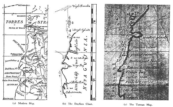
(No. 8) The Carpentaria Coastline.--Three illustrations of the portion of the western coastline of the Cape York Peninsula discovered by the Duyfken as shown on (a) the Queensland State Map, No. 2b, 1931; (b) the Duyfken chart; and (c) Swart's copy of Tasman's map.
{Page 3}
When the chart of the Duyfken first came to my notice, I recognised that I had before me a fascinating document--a copy of the earliest record of the history of Australia as transcribed by the hand of man. It so interested me that I wrote an article upon it, which was published in two instalments in the Sydney Morning Herald on the 2nd and 9th of December, 1933.
My interest continued. I had made a visit to Java in 1929, returning convinced of the importance to Australia of these near-neighbour countries, of which we know so little, and with a profound respect for the Dutch as colonisers. It was therefore a congenial task I set myself when I resolved to find out what was known about the Dutch navigator who in 1606 sailed from Bantam to explore the southern coast of New Guinea, and extended his voyage to make the first discovery of Australian shores.
Who was Willem Jansz, or Janszoon (in plain English, William Johnson), the captain of the Duyfken? Who was Jan Lodewycksz van Roossengin, the Sub-cargo? What were the circumstances under which the expedition was made? What did they have to say about the strange new country they had found?
I searched in vain, in Dutch and Australian histories, for a connected narrative of the voyage. The log of the Duyfken had been lost. Like many another document of historical importance, its value was unrecognised by those who handled it in those busy and exciting early years of the Dutch East India Company. We do not have to go far from home to find examples of the same indifference and neglect.
{Page 4}
If the log, or copies of it, were sent to the headquarters of the company at Amsterdam, they may have been sent to the company's cartographers for the preparation of charts, and not returned; or some iconoclastic clerk may have decided that they took up too much room on the shelves of the record room, and sent them to the incinerator or the pulping-mill, or even to the butcher's; or through careless storage, they may have merely decayed. I do not exclude the possibility that they were stolen, but whatever happened, they disappeared.
There is some evidence that they were sought for in the Indies in 1616, without success; and it is certain that some particulars of the voyage, and a copy of the chart, were available to Jan Carstensz, who followed the Duyfken's track when he went to the Gulf of Carpentaria in command of the Pera and Arnhem in 1623.
Willem Jansz, the captain of the Duyfken, was then an Admiral, and a member of the Council of the Indies, but he was with his fleet in the Philippines when arrangements for the Carstensz voyage were made, and had scarcely returned to Batavia before Carstensz left Amboina. For that reason, Carstensz would have proceeded without the knowledge which Jansz could have given him, which accounts for the paucity of information about the Duyfken voyage in the Pera's log and chart.
The Duyfken chart had a better fate than the log or journal. It was still in existence in Amsterdam when Hessel Gerritsz made his Map of the Pacific in 1622, and placed the Duyfken geography upon it, thus providing us with the first map that contains any part of Australia; it was still in existence about 1670, when a copy was made, which eventually went to the Imperial Library in Vienna and remained buried there for 200 years.
With this copy of the chart as a beginning, I have made searches through the Dutch material available in Australia, the result of which is embodied in the following pages. Piecing together like a mosaic the items so gathered, it is here shown for the first time in English that Willem Jansz was in all probability the Willem Jansz who first went to the Indies in 1598, and, of a certainty, was the Willem Jansz who made a second discovery of the Australian coast in 1618. (Incidentally, on this voyage,
{Page 5}
as Supercargo of the Mauritius, he had with him Anthony van Diemen, travelling as a naval cadet under the assumed name of Teunis Meeuwsen, who became Governor-General of the Dutch East Indies in 1636, and inspired Tasman's voyages in 1642 and 1644.)
Willem Jansz became an Admiral in 1620, and in the following year led a combined Dutch and English fleet against the Spaniards at Manilla.
The Duyfken was possibly the Duyfken of the Dutch first fleet (1595); certainly went to the Indies with Willem Schouten as captain in 1601, and with Willem Jansz as captain in 1603. It was a vessel of 30 lasten or 60 (English) tons, and would have measured about 63 feet in length, 17 or 18 feet in width, with a draught of 7 feet, and carrying 20 men.
The story of the early Dutch discoveries on the coasts of Australia is full of adventure, romance and tragedy. It is a story that has not yet been told. Through these voyages the history of Australia is linked with that of the Dutch East Indies from the very beginning. Jansz, Dirk Hartog, Houtman, Carstensz, Thyssens, Pelsart and Tasman--these and other Dutch discoverers of 1606-1644 commenced the work of placing a continent on the map which Cook triumphantly completed in 1770.
Australia's defence and its economy are as closely linked with the Dutch East Indies as its history, though we have failed to recognise it. The history, literature, science, art, music and trade of these richly-productive and and densely-populated countries which are our nearest northern neighbours are almost a closed book to us. The war has taught us that we must open wide that book of knowledge, if we are to survive as a factor in the Pacific.
T. D. M.
{Page 6}
The story of the finding of Australia, and particularly the story of its first discovery, is one that has intrigued historians and geographers ever since the country was first inhabited. The possibility of its discovery from the west began only after the Cape of Good Hope had been rounded by Bartholomew Diaz in 1486, and, from the east, after Magellan had sailed through his Strait into the Pacific in November, 1520; but it was not until Europeans had been well established in the East Indies that serious thought was given to the likelihood that other richly productive
(No. 1) A Dutch ship of the Duyfken type and time.
{Page 7}
lands existed in the wide wastes of southern oceans.
The Portuguese arrived in the Strait of Malacca in 1509, and d 'Abreu reached the Moluccas in 1512. These dates limit the period of possible discovery from the north, but whatever information d'Abreu or those who followed him may have gained from the Malayans, the Arabs, or the Indian traders in the East Indies concerning lands to the southward of their own, none of it induced the Portuguese, so far as is known, to extend their voyages into Australian waters.
Belief in the existence of a southern land of continental dimensions was more in the minds of cartographers than of seamen, and they exercised their fancy freely on the maps they drew, combining the known with the unknown. Many a league of ocean was sailed in the search for land that was not there--conjectural coastlines of imagination.[1]
[1) An illuminating instance of the wrong conclusions that may be drawn from the evidence of maps alone, without the evidence of voyages to support them, is provided in the case of R. H. Major, who propounded the theory that because old French maps showed land where Australia should be, while Portuguese maps were blank in that region, and the names on the maps were in Provencal French, Australia must have been discovered by a Frenchman in the first half of the 16th century. He supported this theory by producing a copy of a map by Guillaume le Testu. Unfortunately for Major, the original Atlas dated April 5, 1555, was inspected in Paris by an interested Dutchman, who found something that had not been seen by Major. Opposite the map on which appeared the greater part of the alleged "South Land" was the following inscription: "This part is the same land of the south called 'Australie' which has not yet been discovered, because there is no record that anyone has yet searched it out, and because it is only drawn from imagination: I can describe nothing of its advantages, for which reason I shall leave more to be said until more ample discovery has been made. Although I have written and noted a few names on a few capes, this has only been to correct the statements depicted here (which are) the views of others; also in order that those who will be navigating will take care when they think they are approaching the said land."--Abstracted from I. Dornseiffen, "De Ontdekking van Australien," in Tijdschrift van het Aardrijksktundig Genootschap (1877), Deel 2, pp. 49-50.
Apart from the revelation provided by the very frank Frenchman as to the manner in which his map was compiled, this statement has another interest. "Australie" is the French form of Australia, and this, if not the earliest, must be one of the earliest uses of the name as applied specifically to the region of the globe in which Australia is actually located.]
{Page 8}
Notwithstanding the claims advanced on behalf of Spanish, Portuguese and French navigators for the original discovery of Australia, mainly based on this misleading guesswork of cartographers, no evidence that will stand examination has been produced in proof of a single voyage that resulted in the discovery of any part of the known coastline of Australia until the Dutch sent the Duyfken to examine the south coast of New Guinea in 1606.[1]
Of this historic voyage, with which the history of Australia really commences, we have hitherto had but the merest fragments of information, and most of the written histories of Australia either dismiss it timidly, as if doubtful of its reality, or mention it not at all. The Duyfken did not fall like a bird out of the skies to light on a corner of Australia and then vanish as swiftly into thin air; its voyage of discovery was part of a pre-determined plan on the part of the merchants of the Netherlands who controlled the Dutch East India Company to extend their then limited possessions in the East--to seek new countries and new peoples with which to trade.
Its failure in that respect to a substantial degree determined the future of Australia. The Dutch merchants were more concerned with commerce than with discovery; they had neither time, vessels, nor money to spend upon non-essential exploration, and it was both easier and more profitable to them, at that stage of their enterprize, to take trading posts out of the failing hands of the Portuguese than to send their vessels and their men against the twin dangers of unknown coasts and hostile savages.
If, on the other hand, the voyage had been fruitful, or had shown prospects of profitable trade, Australia might well have become a possession of the Netherlands. It was Fate alone that determined that the Duyfken should have visited that portion of Australia's shores which even to-day remains partly unsurveyed and given over as reserves for its aboriginal inhabitants.
Seventeen years were to elapse before the Dutch sent
[1) For a convincing refutation of some of these claims, see G. A. Wood, "Was Australia Known in the Sixteenth Century?"--Royal Australian Historical Society's Journal (1918), Vol. IV., pp. 201-240; also his Discovery of Australia (1922).]
{Page 9}
out another expedition for the purposes of exploration. Even then, the voyage of the Pera and Arnhem of 1623 was ordered in consequence of a number of discoveries, commencing with that of the Eendracht in 1616, which were accidentally made on the western coast of Australia, as a result of an alteration of the sailing route from the Cape of Good Hope to the Indies, directing the vessels, for a quicker passage, to sail east in the region of the "roaring forties."
By 1642, these discoveries by the Dutch in Australian waters were so extensive that it was decided to send out Tasman for a more thorough examination of the southern seas. Tasman's famous voyages of 1642 and 1644 not only proved the non-existence of a continent in the southern Indian Ocean, but revealed the existence of Tasmania and New Zealand, of Tonga and the Fijis, and, on the second voyage, so linked the discoveries on the Australian coast that three-fifths of the outline of Australia was placed on his resultant map. All this was done by the Dutch before the seamen of any other nation had seen any portion of Australia, excepting, only the shipwrecked English sailors of the Trial in May, 1622.[1]
Even then, this extensive country did not attract the Dutch. The fact is that the thousands of miles of northern, western and southern coasts, from the vicinity of Cape York round to the head of the Great Australian Bight, were for the most part barren and offered no prospects of trade. It remained no man's land until 1770, when Lieutenant Cook, after examining Tasman's discovery of New Zealand, decided to "steer westward until we fall in with the E. Coast of New Holland." Thus, the extensive series of discoveries of Australia by the Dutch from 1606 to 1644 led Cook to turn west, instead of east, on his
[1) A Tasman map has been laid in marble mosaic on the floor of the vestibule of the new Public Library building in Sydney. This is not a reproduction of the original, which is in the possession of the Mitchell Library, but a reproduction of Jacob Swart's copy of the original with modernized script as published in his Journaal van Tasman's Reize (Amsterdam, 1860).
For the wreck of the Trial, see Ida Lee, "The First Sighting of Australia by the English," in The Geographical Journal (April, 1934); reprinted in the Royal Australian Historical Society's Journal, Vol. XX., Part V., pp. 274-6.]
{Page 10}
homeward voyage from New Zealand, and, in consequence, to alter also the apparent course of Australia's destiny.
It is my purpose here to re-assemble the fragments of information printed in English, and to endeavour to reconstruct, mainly out of material that has lain buried in the obscurity of the Dutch language, the first of that series of voyages, which enabled a commencement to be made with a drawing of a map of the real, as distinct from the imaginary, Australian continent. At the same time, it is hoped to sketch in the Dutch background of the events in the East Indies which preceded the sending of the Duyfken on her voyage of discovery.
Before the Portuguese sailed to India, the products of the East--spices from the Indies (pepper, cloves and nutmegs); the cinnamon of Ceylon; silk, porcelain and lacquer from China--had been collected in native junks and taken to convenient trading centres--Malacca, Bantam, Amboina, Ternate--from thence to be conveyed by Hindu, Persian and Arab traders to the Gulf of Persia or to the Red Sea, whence they were taken by overland caravans to the ports of the eastern Mediterranean. There they were picked up by Venetian and Genoese ships and distributed to the emporiums of Europe.
In 1453, however, the Turks captured Constantinople, and levied toll on the caravan routes. This so crippled the trade that Portugal determined to find an ocean road. After a period of ever-extending voyages down the west African coast, Diaz, and later Vasco da Gama, found the way round the Cape, and opened the gate to India and the Indies. When D'Albuquerque conquered Malacca in 1511, he laid the foundation of Portuguese power in the East; the spice trade was in the hands of Lisbon, and Venice entered upon the sunset of her golden age.
From Lisbon, the cargoes of the Mediterranean, of West Africa, and the East were taken to the markets of northern Europe mainly in the vessels of the Dutch--the carriers of Europe--but when Spain, at war with the Netherlands, took Portugal in 1580, she closed the port of Lisbon to the Dutch, who found themselves faced with the gravest difficulties. The return of one of their
{Page 11}
countrymen, Linschoten, with a wide knowledge of the Far Eastern trade, and a narrative as fascinating as that of Marco Polo, inspired the Dutch with a new hope and a new determination: they would fit out a fleet and seek the sources of supply for themselves. They had, too, the man to lead it--Cornelis de Houtman--who had secured, while in Lisbon, charts of the Portuguese sea routes to the East Indies.[1]
(No. 2) The Four Vessels of the Dutch First Fleet.
The first fleet of the Dutch to the East Indies left Holland on April 2, 1595. The vessels of that fleet were the Mauritius, Hollandia, Amsterdam, and the Duyfken. The larger vessels were described as being of 400 (English) tons, and the Amsterdam of 200 tons; but the Duyfken was a smaller vessel, and four different accounts give her tonnage as 30, 40, 50, and 50 tons respectively.[2] The
[1) E. S. De Klerck: History of the Netherlands East Indies, Vol. I. (1938).]
[2) De Eerste Schipvaart naar Oost-Indie, Vol. II. (Linschoten-Vereeniging, 1925), p. 117.]
{Page 12}
Duyfken has always been described as a yacht or pinnace, but that description has no relation to the modern use of those terms. All these vessels were of the same construction--all had three masts; the only difference between the yacht and the other ships was the size. The Duyfken carried twenty men, and was armed with two large and six small guns and four stone-slingers. As she had to carry stores for a journey half way round the world, and in case of separation would have to depend on her own supplies, I think it most likely she was at least 50-60 tons. I have not found another record of so small a vessel as this making a voyage from Holland to the East Indies. It has to be remembered, too, that as yet the Dutch had not been able to arrange places on the route for the refreshment of their crews.
In a purely commercial sense, the expedition was scarcely a success. Before the ships reached Madagascar seventy men had died of scurvy, and a small island on the south coast of that country was inscribed on maps for many years as the "Dutchmen's Graveyard." The commercial leader, Cornelis de Houtman, was not a diplomat; he became embroiled in disputes with the natives, with the Portuguese, and with his own men. Many lives were lost in these quarrels; one ship, the Amsterdam, was abandoned and burnt at the Island of Bawean, off the coast of Java; three of the four skippers died.[1] After an absence of two and a half years the remaining three vessels limped back to Holland on August 11 and 14, 1597, with eighty-nine men out of a total of 249.
They had proved, however, that they could make the passage to Java; that there was good trade to be done there; that the Portuguese were not to be feared either as naval or commercial rivals; and they had no sooner returned than steps were taken to fit out a second fleet, larger and better equipped than the first.
[1) At Sidayu, Java, Schellinger, captain of the Amsterdam, was presented with an "Eeme"--a cassowary, coming from Ceram (Old Javanese, swari; Malay Javanese, kasoewari; Portuguese, emaostrich; from the Arabic, na-ama, an ostrich--compared by the Portuguese to a cassowary). It is from the Portuguese word Ema--also spelt Eeme, Eme, Emeu--that we get the name for the Australian Emu. The bird was taken to Amsterdam, but Schellinger was murdered at Sidayu.]
{Page 13}
This second fleet, which left Holland on May 1, 1598, under the command of Admiral van Neck, comprised eight vessels, including the Mauritius and the Hollandia of the first fleet, a new vessel named the Amsterdam, and five others named after provinces of the Netherlands--Zeelandia, Geldria, Utrecht, Vriesland--and a smaller ship or "yacht" named the Overyssel, which, "according to reliable writings," was the former Duyfken.
On the Hollandia was Willem Jansz, as stuurman, or mate; another member of the crew was Jan Lodewycksz. We thus have introduced to the East Indies two men who were to become associated, seven years later, in a voyage during which the first discovery of Australia was made.
And what of the ship? Here I find myself confronted with a problem of great perplexity. The question is: "Was the Duyfken of the Dutch first fleet the same vessel that made the first voyage with Europeans to Australia in 1606?" The documents available to me do not provide an answer to this question, which, in all probability, will be solved only by a close inspection of the papers in the Rijksarchief at The Hague. I can do no more than present the evidence available here.[1]
As previously stated, the Duyfken was one of the four vessels which left Holland in 1595, three of which, including the Duyfken, returned in 1597. The Duyfken does not come into the record again until April 23, 1601, when a vessel of that name sailed to the Indies as one of the fleet of Wolphert Harmensz, under the command of Willem Cornelis Schouten, who in 1615-1616 was to achieve immortality with Jacob Le Maire by being the first men to sail round Cape Horn, named after the town from which they came, which was also the name of one of their vessels.
[1) Unless otherwise stated, the particulars of the early Dutch voyages have been abstracted from Isaac Commelin, Het Begin ende Voortgangh der Vereenighde Nederlantsche Geoctroyeerde Oost-Indische Compagnie (1646)--(Beginning and Progress of the United Netherlands Chartered East-India Company); J. K. J. de Jonge, De Opkomst van het Nederlandsch Gezag in Oost-Indie (1862 and following); and from the relative publications of the Linschoten-Vereeniging.]
{Page 14}
What was the Duyfken doing between 1597 and 1601? It is inconceivable that the prudent Dutch would waste a vessel which had proved itself seaworthy and suitable for a world-wide voyage, in trading between European coastal ports. Besides, they refitted and sent out the other two vessels which had returned. We seem to have found a partial answer in the statement that the Duyfken was renamed the Overyssel for the second voyage. But, in the best account of that voyage, we find the contradictory statements (a) that the Overyssel was the former Duyfken, and (b) that the vessel was of 45 lasten, or 90 (English) tons. There were twenty men on the Overyssel, and she carried an armament of two large and six small guns, and four stone-slingers--exactly the same, in each case, as the Duyfken of the first voyage.[1] One would think, therefore, that there had been some mistake in the record of the tonnage, and that 45 lasten should read 25. But this would not solve the problem, as the Overyssel returned, was refitted, and went out as the Overyssel again in Admiral van Neck's second voyage, being one of the advance guard of four ships under Vice-Admiral Jacob Wilkens on December 21, 1599.
This vessel was actually in the East Indies when, on April 23, 1601, a Duyfken sailed from Holland in the fleet of Wolphert Harmensz. The tonnage of the Duyfken of Harmensz's fleet is given as 25 and 30 lasten[2]; it returned to Holland in April, 1603, and sailed again on December 18 of that year in the fleet of Steven van der Hagen. This time the tonnage is given as 30 lasten. It is certain that they were one and the same vessel, but I can find no explanation that will not leave gaps to be bridged between the dates of the Duyfken of the first fleet (1595-7) and that of Wolphert Harmensz (1601), and so am compelled to leave it an open question, hoping, for the sake of its interest in Australian history, that the archives of the Netherlands, in the better days to come, will provide the answer.
[1) De Tweede Schipvaart naar Oost-Indie, Vol. I., chap. iv. Purchas his Pilgrimes (1625), Vol. I., p. 708, in an account of the second voyage, also refers to the "Overyssel, or Dove."]
[2) J. K. J. de Jonge: De Opkomst, Vol. II., pp. 529-530.]
{Page 15}
We return now to Willem Jansz, whose first voyage to the Indies was as mate on the Hollandia of the fleet of van Neck. This voyage was a great success. On the way out, they landed first at the island of St Laurence, or Madagascar, and then at the island of Cerne, which they renamed Mauritius, after the Stadtholder of the Netherlands. It appeared to be uninhabited, but here they obtained an abundance of refreshment for their crews. It became thereafter the principal place of call for the Dutch fleets en route to and from the Indies.
At Bantam, in Java, van Neck was able to load four of his vessels to the gunwales with spices, with which he returned to Holland, showing a profit of 400 per cent. With him returned Willem Jansz. The other four vessels were ordered to the Moluccas--the first Dutch vessels to sail there. From Amboina, Vice-Admiral van Warwyck went to Ternate with the Amsterdam and Utrecht, while Vice-Admiral Jacob van Heemskerck went to Banda with the Gelderland and Zeeland, where he not only loaded his ships with a full cargo of nutmegs and mace, but established two trading posts and left men to look after them. One of the men he left, at Banda Lontor, was Jan Lódewycksz.
As a result of the great success of van Neck's voyage, a large fleet was organized. His four ships were overhauled, new ropes, sails, anchors, victuals and merchandise were provided, and sent out as an advance guard on December 21, 1599, under Vice-Admiral Jacob Wilkens. This time, Willem Jansz went as opperstuurman, or first mate, on the Hollandia. On his return from his first voyage he had handed his log to Petrus Plancius, the famous Dutch teacher of navigation, so that he could have been no ordinary seaman.
On this voyage, too, went a second Jan Lodewycksz, as opperkommies, or chief merchant, on the Mauritius. It was the arrival of this man in the Indies that caused' the first one of that name to add to his name the words "van Roossengin," no doubt to avoid confusion. It has been
{Page 16}
assumed[1] that he gave this name to the island Rozengain, of the Banda group; on the contrary, he took his name from the island, no doubt from his personal interest in it while stationed at Banda Lontor. Rozengain is the most easterly of the Banda group, and one-half of it is to-day occupied by a nutmeg plantation, the other half by djati (teak) trees. Its name was known before the voyage of Magellan—del Cano (1519-1522), as in Pigafetta's account of that voyage it is referred to and charted as Rosoghin and Rossoghin.[2] It was as Jan Roossengin (the surname is spelt in various ways) that the first Jan Lodewycksz was henceforth to be known.[3]
It is not clear. upon what ship Willem Jansz returned to Holland, but on May 5, 1601, a Willem Jansz sailed again for the Indies as master of the Lam, in the "Ram, Schaep, and Lam" fleet of Joris van Spilbergen. During this voyage, Spilbergen named Table Bay in South Africa. On the voyage Jansz was transferred, as mate, to the Ram. They arrived off the northern coast of Sumatra on September 16, 1602, and, when Spilbergen went off with the English captains Lancaster and Middleton to capture a richly-laden Portuguese ship, the Ram stayed on the Sumatran coast. Our interest here lies in the fact that when Steven van der Hagen left Holland in December, 1603, with his fleet for the Indies, he carried with him a chart of the. Malayan coast, prepared by Willem Jansz in September—October, 1602. Again from the material available in Australia, it is not possible to say how Jansz got back to Holland; but if a chart could reach Holland so could the man who made it, and it was Willem Jansz who went out with Steven van der Hagen's fleet as captain of the Duyfken.
The Duyfken had returned to Holland in February of that year (1603) after a voyage to the Indies in the fleet
[1) By L. C. D. van Dijk: Twee tochten naar de Golf van Carpentaria (Amsterdam, 1859).]
[2) Blair and Robertson: The Philippine Islands (1906), Vol. XXXIV., pp. 111, 115.]
[3) Roossengin--pronounced Rose'-en-hin.]
{Page 17}
of Jacob Heemskerck, and under the captaincy of Willem Schouten. From Bantam, part of the fleet had gone to Banda under the command of Wolphert Harmensz. On arrival at Banda on March 14, 1602, they found Adriaen van Veen, who had been left there with a party including Jan Lodewycksz, or Roossengin, since 1599.
At a meeting of the ships' officers on April 10, 1602, it was decided to send the Duyfken, under the command of Schouten and Super-cargo Claesz Gaeff, to Ceram, to visit some harbours there, take in sago, and ascertain from the natives whether they had any knowledge of the trade of New Guinea; in particular, whether they had any knowledge of the Portuguese trading there.[1] The report brought back was inconclusive, but it would appear that the Duyfken visited the island of Misool, off the west end of New Guinea, because Harmensz's Journal relates that on that island "there is a great demand for cloth, gold, gongs, iron, and swords."[2] The Duyfken could not have been out for more than two months, for on June 24, 1602, Harmensz sailed for Bantam, where he left the Supercargo Claesz Gaeff and the Sub-cargo Jan Lodewycksz (Roossengin) to look after the company's stores and interests.
When the Duyfken was refitted, on her return to Holland, she was placed under the command of Willem Jansz, and sailed again to the Indies in the great fleet of Steven van der Hagen on December 18, 1603. This fleet of twelve vessels was better armed than any that had previously sailed, and the instructions given to the Admiral read more like a war manifesto than those of a commercial enterprize. He had to take a position at Mozambique to attack the Spanish—Portuguese ships, after which he was to go to the coast of India and burn the ships of the enemy and display the flag of Holland before Goa, the centre of Portuguese might in India. He was also to clear the
[1) J. E. Heeres: The Part Borne by the Dutch in the Discovery of Australia (London, 1899)]
[2) P. A. Leupe: De Reizen der Nederlanders Tangs de Noordkust van Nieuw-Guinea (1875).]
{Page 18}
Moluccas of the Spanish and the Portuguese. He was able to bring about only minor and ineffective engagements with the Portuguese on the coasts of India. When he reached Bantam, however, on December 31, 1604, he heard that the fort of van Verre, which he had himself established at Amboina on a previous voyage (1599-1601), had been taken by the Portuguese, and he decided to go there. After appointing Jan Willem Verschoor as Chief Merchant at Bantam, he sailed for Amboina, where he immediately made an attack on the Portuguese fort, which surrendered in two days (February 25, 1605). Here he appointed Frederik de Houtman[1] as Governor of Amboina, the first territory the Dutch had secured for themselves in the East Indies. His fleet then split in two, van der Hagen sailing with the United Provinces and the Duyfken to Banda, where he made contracts with the native chiefs and gave command of the trading post to Super-cargo Hendrik van Bergel.
The orders of the Council in Holland to Steven van der Hagen were that he was to leave his two smaller vessels, the Delft and the Duyfken, in the Indies for at least three years, to sail from one place to another for the purposes of discovering new sources of trade to the advantage of the company. Accordingly we find him in September, 1605, returning with his fully-laden ship and the Duyfken to Bantam, from whence he sailed for Holland in the following month. The Duyfken remained at
[1) Frederik de Houtman was a younger brother of Cornelis de Houtman, leader of the first Dutch fleet to the East Indies. In 1598 they made a second voyage, but at Achin, Sumatra, Cornelis was killed (1599) and Frederik taken prisoner. In August, 1601, he was freed by a Dutch fleet under Laurens Bicker. Houtman was Governor of Amboina 1605-1611. On July 19, 1619, Commander F. Houtman (of the Dordrecht) and Super-cargo Jacob Dedel (of the Amsterdam) sighted the western coast of Australia near Fremantle, and sailed north along the coast for over 400 miles. Houtman's Abrolhos is a permanent memorial to his name. During his imprisonment 'in Sumatra he compiled a dictionary of Malayan. and Madagascan words, to which was added an appendix on the declinations of many of the stars around the South Pole.--D. Sepp: Tresoor der Zee- en Landreizen (Linschoten—Vereeniging, 1939).]
{Page 19}
Bantam to be fitted with her requirements for the voyage to "Nova ginnea," which was to become historic.
There would appear to be good reason to believe that the voyage of the Duyfken for the discovery of New Guinea was directed by Steven van der Hagen, in accordance with his instructions. As he left almost immediately for Holland, however, the responsibility for the furtherance of those instructions would devolve on someone else. At that time, the chief Dutch trading station in the East Indies was Amboina, which had been taken from the Portuguese, and where a Governor, Frederik de Houtman, had been appointed. The position of Verschoor at Bantam was inferior to that of Houtman; he was a chief merchant, or commercial agent.[1]
The English East India Company also had an agent at Bantam, Captain John Saris, and on November 18, 1605, Captain Saris entered the following record in his diary:--
The eighteenth, heere departed a small pinnasse of the Flemmings, for the discovery of the nand called Nova ginnea, which, as it is said, affordeth great store of Gold...[2]
A few months later, he received further news, and made another entry:--
The fifteenth of June (1606) heere arrived Nockhoda Tingall a Cling-man from Banda, in a Java Juncke, laden with mace and 'nutmegs, the which he sold to the Guzerats; he told me that the
[1) "The yacht Duyfken, skipper Willem Jansz, in 1605 was placed at the disposal of Gov. Frederik Houtman at Amboina by Adm. Steven van der Hagen. Houtman gave orders for an expedition to the so-called southern lands to . Skipper Willem Jansz, but as Jansz had to obtain some very necessary provisions and ship's stores before he could sail, Houtman sent him to Bantam with orders to the President Jan Willem Verschoor asking him to be of help to the skipper."--P. A. Leupe: De Reizen der Nederlanders naar het Suidland of Nieuw Holland (1868), p. 7.
For instructions to Steven van der Hagen, see J. K. J. de Jonge: De Opkomst van het Nederlandsch Gezag in Oost-Indie, Vol. III., p. 147.]
[2) Purchase His Pilgrimes (1625), Vol. I., Book 4, p. 385.
Alvaro de Saavedra, sailing along the northern coast of New Guinea in 1528-1529, named the land the "Isla del Oro"; Inigo Ortez de Retes, in 1545, renamed it Nueva Guinea.]
{Page 20}
Flemmings Pinnasse which went upon discovery for Nova Ginny, was returned to Banda, having found the Iland: but in sending their men on shoare to intreate of Trade, there were nine of them killed by the Heathens, which are man-eaters: so they were constrained to returne, finding no good to be done there.[1]
Captain Saris could not have foreseen that his brief entries were to provide the first, the most important, and the only contemporary record of a voyage during which the first discovery of Australia had been made. Although the names of the ship and its commander were not mentioned, and the extent of the voyage was unrecorded, it was, and it remains, the only record that gives the dates of the departure and return of this vessel. From September, 1605, until March 4, 1607, no Dutch record of any kind has been preserved that gives any reference to the movements of the Duyfken. On the latter date, however, Paulus van Solt made the following entry in his Journal:--
On the 4th of March, 1607, through God's mercy arrived before the Castle [of Victoria, Amboina]...here we found...the yacht Duyfken, which had come from Nova Guinea.[2]
Whether this relates to the voyage which ended at Banda in May, 1606, or to another voyage in New Guinea waters, which is more likely, has not been established.
Captain Saris having provided us with the dates, for the names of the ship and its officers we have to look to a Dutch document written thirteen years later.
The United East India Company (Vereenigde Oost-Indische Compagnie), established under charter in 1602 with State support and authority, and given a monopoly of the East Indian trade, found itself obliged to protest against the claims of a rival company--the Australische Company--which in 1615 had sent the expedition of Schouten and Le Maire to the East Indies by way of South America and the Pacific, and in a memorandum laid before the Council on August 2, 1618, claimed that the new company should be excluded from the territory between Ceylon and 100 miles east of the Solomon Islands:--
[1) Nockhoda, master or proprietor of a trading vessel; Cling-man--Kling, a Tamil from the mid-east coast of India; Guzerats, traders from the west coast of India; Flemmings, Netherlanders.]
[2) J. E. Heeres: Part Borne by the Dutch...]
{Page 21}
...seeing that the United East-India Company has repeatedly given orders for the discovering and exploring the land of Nova Guinea, and the islands east of the same, since, equally by our orders, such discovery was once tried about the year 1606 with the yacht de Duyve by Skipper Willem Jansz and sub-cargo Jan Lodewijs van Rosinghijn, who made sundry discoveries on. the said coast of Nova Guinea, as is amply set forth in their journals.[1]
The next document that refers specifically to the voyage of the Duyfken is the "Instructions to Commander Abel Jansen Tasman," at Batavia on January 29, 1644, when he was "destined for the further discovery. of Nova Guinea and of the unknown coasts of the discovered East and South lands together with the channels and islands presumably situated between and near the same," wherein the earlier voyages were recounted:--
...the first was undertaken. in the year 1606 with the yacht 't Duijffken, by order of President Jan Willemsz Verschoor (who then managed the Company's affairs in. Bantam) on which voyage the Islands of Key and Arouw were visited in passing, and the unknown south and west coasts of Nova Guinea were discovered over a length of 220 miles from 5 to 13¾ degrees southern latitude, it being only ascertained that vast regions were for the greater part uncultivated, and certain parts inhabited by savage, cruel black barbarians who slew some of our sailors, so that no information was obtained touching the exact situation of the country and regarding the commodities obtainable and in demand there; our men having by want of provisions and other necessaries been compelled to return and give up the discovery they had begun, only registering in their chart, with the name of Cape Keerweer, the extreme point of the discovered land in 131 degrees southern latitude.[2]
These three references have formed the basis of our limited knowledge of the voyage of the Duyfken in 1605-6. Together, they establish (a) the date of the voyage; (b) the name of the ship, its captain and its sub-cargo or commercial director, who, in accordance with Dutch practice of the time, was in charge of the management of the voyage, as distinct from the navigation; and (c) the extent of the voyage.
They are not, however, the only references that establish the authenticity of the voyage. On September
[1) Heeres: Part Borne by the Dutch..., p. 5.]
[2) J. E. Heeres: Abel Tasman's Journal (1898), p. 147.]
{Page 22}
22, 1616, Governor-General Reael wrote to J. P. Coen: "If J. Rossengeyn should arrive [at Bantam] please demand from him the journal of his voyage to New Guinea."[1] Roossengin was then in the Philippines, and did not return to Bantam until December, 1617, when Reael was there, but nothing has been found relating to the journal. After Reael returned to Holland in 1620, the Directors wrote to Coen asking him to forward the writings, drawings and descriptions of New Guinea and the South Land beyond Java that Reael had left with the Council of the Indies Coen replied that he knew nothing whatever about them.
Reael's original inquiry was obviously a consequence of the decision of the Directors on October 8, 1616, to send a second expedition to extend the explorations of the Duyfken. Instructions to that effect were in fact given, Reael reporting to the Directors on May 10, 1617, that Cornelis Dedel had been despatched from the Moluccas "to proceed to the discovery of the southern lands, which undertaking had once previously been engaged in by Jan Rossangin on the order of Admiral van der Hagen." Dedel, however, did not go beyond Amboina, there becoming engaged in other and more pressing duties.[2]
It was not until 1623 that a second expedition went out specifically for the discovery of the unknown south lands. This was the expedition of the Pera and the Arnhem. Fortunately the journal of Jan Carstensz, captain of the Pera, has been preserved. This journal makes four references to the voyage of the Duyfken, the track of which was followed. These references will be mentioned later.
To these records, Professor Heeres adds the evidence of the map "Indiae Orientalis nova descriptio," by Joannes Janssonius of Amsterdam, from the Mercator-Hondius Atlas, new edition, 1633. There is no date on the face of this map, but it was probably done about 1630. It
[1) Leupe: Nieuw-Guinea, p. 5.]
[2) van Dijk, Twee tochten..., p. viii.; and Heeres, Part Borne by the Dutch...]
{Page 23}
contains five names obviously taken from a chart or map of the Duyfken's voyage, all of them with slightly altered spelling, which, in two cases at least ("eylandt" for "landt"), alters the sense of the inscription, but all of them on the New Guinea portion of the map. The place where Cape York Peninsula should be is occupied by a scroll to enclose the mileage scale.[1]
On the other hand, the Henry Hondius map of 1630, which is from the same atlas, and is described by C. H. Coote as "the earliest attempt to delineate in a popular form the early discoveries in the Gulf of Carpentaria, representing the discoveries of Jansz and Carstensz," does not contain a single name from the Duyfken voyage of 1606, but has only the names given to the coast after the Pera voyage of 1623.[2]
Philip Eckebrecht's map of 1630, which is the first world map to include the discoveries of the Dutch on the coast of Western Australia, also has the Pera geography only at the south coast of New Guinea and the Gulf.[3]
Obviously unknown to Heeres, and re-located by Dr F. C. Wieder in recent years, is a magnificent map of the Pacific Ocean by Hessel Gerritsz, the great Dutch cartographer, which is not only the first map upon which the lands discovered by the Duyfken were inscribed, and therefore the first map to contain any part of the actual, as distinct from the hypothetical, mainland of Australia, but is the "Map of the Great South Sea" so often consulted by Tasman when, in 1642, he accomplished the remarkable feat of completely circumnavigating the continent of Australia without seeing any of it, although on the same voyage he discovered the southern coast of Tasmania, the west coast of New Zealand, and some of the islands of the Tonga and Fiji groups.
This map was found in the Depot des Cartes de la
[1) Remarkable Maps, edited by C. H. Coote (Amsterdam, 1895), Part 2, No. 7.]
[2) Remarkable Maps (ed. C. H. Coote), Part 2, No. 6.]
[3) Remarkable Maps (ed. C. H. Coote), Part 2, No. 8.]
{Page 24}
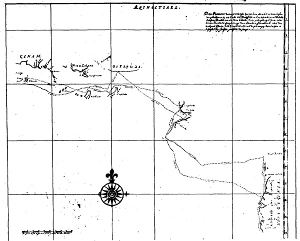
(No. 3) Hessel Gerritsz's Map of the Pacific, 1622.
The first map to show any part of the real Australia, here named
"Neuva Guinea."
{Page 25}
Marine in Paris. From the point of view of Australasian historical geography it is one of the most important maps in existence. It has never been published (although Dr Wieder in 1933 announced his intention so to do) and, so far as I can ascertain, there is only one coloured copy of it; this is in the Mitchell Library, Sydney, the Trustees having ordered a copy to be made as soon as its discovery was made known to them by Professor G. C. Henderson. Wieder says "the principal aim of the map was to check the position of the Insulae Salomonis," but it also sets down the track of Schouten and Le Maire and other Pacific discoveries at that time known.
The date on this map is 1634, but it has been closely examined by Dr Wieder and by Professor Henderson, and they agree that the date has been deliberately altered, the real date being 1622. Henderson devotes a chapter to it in his Discoverers of the Fiji Islands, and a photograph of portion of the original, therein reproduced, and the facsimile of the original, clearly support this contention, apart altogether from evidences on the face of the map itself. For example, it is inconceivable that Gerritsz, official cartographer to the East India Company, if he had made so elaborate a map in 1634, would have failed to place upon it the Dutch discoveries on the Western Australian coast made between 1616 and 1622 which he had already placed on his maps in 1627. Furthermore, Hessel Gerritsz died in 1632.
The western side of the map has the following inscription. Translated it reads:--
Nieu Zeelandt east of Ceram sailed into by Jaspar Jansz de Jonghe, Duyfkensland opposite Kei and Aru, Modder island, the Vuyle-bancken and coast from 9 to 14 degrees sailed into by J. Rosingein, the north coast of the Papuas with. its continuation to 246 miles east of Maba travelled by J. le Mair, here laid down as they are drawn by the named discoverers, were all held to be parts of New Guinea. What more of these is found in the Spanish maps, very different from one another, and not fitting well with these parts, is here left out until more clarity is obtained. These [parts] were sailed into with the yacht of Pedro Fernando de Quiros about New Guinea on 10 degrees westwards through many islands and dry banks and over 2, 3, and 4 fathoms for full 40 days. Presuming New Guinea not to stretch over the 10 degrees to the south--if this were
{Page 26}
the case--then the land from 9 to 14 degrees must be separate and different from the other New Guinea.[1]
This inscription lets in a flood of light on Dutch knowledge of Torres Strait in or prior to 1622. First, it is clear that the only information the Dutch had from their own navigators was that gained on the voyage of the Duyfken. The reference to Jasper Jansz de Jonge is taken from the Duyfken chart; the reference to J. Roossengin is to the Duyfken voyage of 1606; the reference to Jacob le Maire is to his voyage across the Pacific and along the north coast of New Guinea in 1615-1616. But the reference to "the yacht of Quiros" indicates that Hessel Gerritsz had come into possession of Spanish maps or manuscripts that revealed the voyage of Torres, who had left Quiros at Espiritu Santo and had sailed westward on 10 degrees through many islands, dry banks and shallow waters "for full 40 days" (i.e., through Torres Strait), and if that were so it was to be presumed that New Guinea could not extend below 10 degrees south latitude; in which case, the land shown as extending to 14 degrees and marked as New Guinea on the Duyfken chart (i.e., Cape York Peninsula) must be a different land altogether. The Spanish maps were "very different from one another," and did not fit in with Dutch charting at all. Their longitudes were hopelessly inaccurate. Therefore, the doubtful, cautious Dutch cartographer left them out, although he had shown Torres Strait (unnamed) on his world map of 1612.
This map makes it clear that the Dutch in 1622 were
[1) Hessel Gerritsz published in Amsterdam in 1612 a Dutch translation of the eighth memorial of Quiros, the title page of which includes the words, "'t Land ghenaemt Australia Incognita." This is believed to be "the earliest occurrence in print of the word Australia outside Spain." The first to draw attention to this interesting fact was Dr A. Lodewyckz: "The. Name of Australia," Victorian Historical Magazine (1929), Vol. XIII., pp. 99-115. The publication of 1612 referred to included Isaac Massa's description of Siberia (Samoyeden Landt), his short account of the roads from Muscovy, and the memorial mentioned. It included three maps, one of which was a map of the world by Gerritsz, in which Torres Strait is clearly shown. Gerritsz was cartographer for the Netherlands East India Company, 1617-1632.]
{Page 27}
still not certain that Torres Strait existed. They were to make other attempts to solve this problem for themselves (Carstensz, 1623; Tasman, 1644; Gonzal and van Aasschens, 1756), but it was to remain a problem until Cook cleared up the "doubtful point" in 1770. Nevertheless, it will be noted that the careful Gerritsz did not link up the discovered areas; he left the Strait and the problem open "until more clarity is obtained." On this evidence, historians must acquit the Dutch of concealing knowledge of Torres Strait; they simply did not regard the evidence of Spanish maps alone as sufficient--they had been deceived by them before; the evidence of Torres' voyage did not fit in with their own knowledge; nothing but proof of a voyage would convince them. For which view there is much to be said.
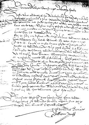
From whence did Hessel Gerritsz derive his information of the Australian coast? The answer is revealed in a copy of the chart of the Duyfken's voyage, which was brought to light and published by Dr F. C. Wieder in his Monumenta Cartographica in 1933. Australia has been thus provided with a copy of the earliest record of its history.
Of the authenticity of this copy there can be no question. Its history is as follows. Laurens van der Hem (1621-1678) was a wealthy solicitor of Amsterdam, whose hobby was the collection of maps. He already possessed a copy of Blaeu's atlas of eleven volumes, and to this he added, in uniform style, and obviously with the permission of the Directors of the Dutch East India Company, copies of the original maps or charts belonging to that company. They are all similar in style, colouring and handwriting, and none of them have any compass lines. Dr Wieder concludes, therefore, that they were all done by the one man, or under the direction of one man, and, from evidences within the atlas, about the year 1670.
This atlas was sold at public auction at The Hague in November, 1730, a printed catalogue describing it sheet by sheet. It was purchased by Prince Eugene of Savoy, whose heiress in 1737 sold his whole library to the Hofbibliothek in Vienna. It was while examining this
{Page 28}
atlas, which is of forty-six volumes, first in 1920 and again in 1931, that Dr Wieder found it to contain the "Secret Atlas of the East-India Company "--copies of originals no longer in the company's archives--and included were the charts of the voyages of the Duyfken to New Guinea and Australia in 1606, and of the Arnhem, which accompanied the Pera in 1623.
The chart of the Duyfken is unusually informative, in that it shows the whole course of the vessel from Banda on the outward and the homeward voyages; it shows the points on the southern coast of New Guinea that, were first seen by Europeans; it reveals the fact that the Duyfken visited the Kei and the Aru Islands; it shows the actual landfall on the coast of Australia; and it definitely locates the doubted position of Cape Keerweer. It possesses, too, this additional merit: it delineates the lands actually . located, and does not include coastlines of conjecture. It is a good map, much clearer and more accurate in its outline of the Carpentaria coastline than the later maps of Arent Martensz de Leeuw, of the Pera, 1623, or that of Tasman, 1644, and maps based upon them.
The Duyfken chart disposes of all previous speculations as to the route of the voyage. After leaving Banda in September, 1605, under Captain Willem Jansz, in company with the United Provinces under Admiral van der Hagen, the Duyfken sailed to Bantam to be fitted and victualled' for her, voyage of discovery. At Bantam she took on board Jan Lodewycksz van Roossengin, who had been there since 1602, to act as Sub-cargo, and left, as Saris states, On November 18, 1605. She would have returned, via Amboina, where the company's headquarters were then located, to Banda. The track from Bantam to Banda is not shown; it was well enough known. In the absence of the log, it is not possible to calculate with any . degree of accuracy the dates of arrival or departure at various stages of the journey; one cannot say how long the ship may have anchored at various places to examine the country, make contact with the natives, and consider the possibilities of trade. We may assume, however, that the journey from Bantam to Banda would take at least a
{Page 29}
(No. 4) The chart of the Duyfken, 1606.
{Page 30}
month, and that therefore the new year had opened before the Duyfken entered unknown waters.
While Willem Jansz, in the Duyfken, was sailing east, another famous navigator was sailing west. Quiros, in command of a Spanish expedition, left Callao, Peru, on December 21, 1605, with Torres as captain of one of his ships, the San Pedro. The Dutch seamen were to sail across the western entrance to Torres Strait, down into the Gulf of Carpentaria, recross the Strait and return to Banda before Torres left the New Hebrides to sail westward through the Strait that now bears his name. The Duyfken was back at Banda before the end of May. Torres left Espiritu Santo about June 28, and cleared the Strait early in October.[1]
From Banda the Duyfken's course was east-south-east to the Kei group, where a call was made at the largest island, passing north of some small islands, one of which was named Thore (Tior of the Admiralty chart?). From Kei the island was turned on the north, and a course set for Aru, where a call was made well down the coast to a point that is clearly the present-day Dobo, chief port now, and probably then. Leaving Aru, the same east-southeasterly course was set, and the Duyfken reached the New Guinea coast at De Jong's Point, in the bight formed between Frederik Hendrik Island and the mainland.[2] It is evident that the Duyfken spent some considerable time
[1) Captain F. J. Bayldon: "Voyage of Torres," Royal Australian Historical Society's Journal, Vol. XI., p. 158; Vol. XVI., p. 133.]
[1) Carstenszoon's Journal, printed in Heeres's Part Borne by the Dutch..., refers to this place as "Keerweer, formerly mistaken for a group of islands by the men of the Duyfken in the year 1606." The Duyfken chart does not show it as a group of islands, but as a broken coast. Moreover, the words on the chart are lowland and muddyland, not "island." It would appear that the Pera carried an imperfect copy of the original chart. The Keerweer of the Pera, on the New Guinea coast, has deceived some historians, who believed that this was the furthest point reached by the Duyfken. The Keerweer of the Duyfken was on the coast of the Gulf of Carpentaria. Keerweer means, literally, a blind alley, or cul-de-sac; used nautically for "turn about"--hence "turn again."]
{Page 31}
there endeavouring to find a way through to the south, but the Princess Marianne Strait, which runs through, would be too difficult for the Duyfken to tack in. Coming out, she rounded the long shoal off False Cape and headed south through the Arafura Sea until she was in the waters of the Gulf of Carpentaria.
If she had then turned west she would soon have reached the coast of Arnhem land; instead, she turned south-east and met the coast of Australia at the mouth of the Pennefather River, on the Cape York Peninsula. There can be no mistake about this locality. The latitudes on the chart are out by many minutes, but the physical features on the chart are unmistakeable. There is a large river shown to the north which can be identified as the Batavia; there is a large bay to the south which is clearly Albatross Bay--it can be nowhere else. The Pennefather River is midway between, and here we have the landfall of the Duyfken more certainly than we have the landfall of Captain Cook at Point Hicks.
On the Duyfken chart it is named "R. met het Bosch"--river with the bush. Our Admiralty chart (No. 445) gives it as the Coen River, an ancient error (derived from the 1802 survey of Flinders, who carried Thevenot's inaccurate map), which one would not expect to see maintained on an Admiralty chart.[1]
Proceeding due south, and crossing Albatross Bay (named Vliege Bay on the chart, a name subsequently placed on the map of Tasman), the next feature shown can again be identified beyond doubt, both by its position and. its name; it is described as "Dubbelde Rev" (Double River); it is in fact a double river, since here at Archer Bay empty the Archer and the Watson Rivers, though Queensland official maps, and not Admiralty charts, must be examined for the necessary identification.
The same applies to the next river south, given on the chart as "R. Vis." This is shown on the Queensland
[1) It is from the Dutch word "bosch" that we derive the word "bush" as applied to country away from the towns. Here we find it in the first place name given to any part of Australia!]
{Page 32}
four-mile maps as the Dugally River. Hessel Gerritsz, on his map of 1622, extended the spelling to "R. Visch," and here one might reasonably assume that the men of the Duyfken threw out their lines or nets and obtained a good haul of fish, which led them to express their appreciation by naming the place in token of the occasion. On the Tasman map the name of "Visschers revier" has been given to the coast in this locality, which has misled many into the belief that Tasman's pilot, Francis Visscher, was thus honoured. The Duyfken chart disposes of that illusion.
The last point named on the chart is Cabo Keerweer, placed in latitude 13.40 south. Its actual location is 13.59. Again, the identification is easy; south of it, the coast bears away south-south-east, as it does in fact. There is nothing at Cape Keerweer to distinguish it from any other part of the low, sandy coast north and south. Carstensz, of the Pera, whose log has been preserved and published, does not mention it; Tasman's journal has not been found, but it is placed on his map nearly a degree too far south.
Matthew Flinders, who was the next navigator to go so far down the Carpentaria coast, in 1802 sought for it, and said:--
"I could see nothing like a cape here; but the southern extreme of the land, seen from the masthead, projects a little, and from respect to antiquity the Dutch name is there preserved. We passed the southern extremity of Cape Keerweer, round which the coast falls back somewhat; the water then' became more shallow, and did not admit of being safely approached nearer than 4 miles."
The little Duyfken, equipped no doubt for a voyage of about six months' duration, had now been out from Bantam nearly four months; day after day she had been sailing along a flat, uninteresting coastline, with no sign of a village anywhere, no sign of a hill from the masthead, and every attempt at a landing opposed by naked, hostile aboriginals with spears in their hands. The land was getting even lower and the waters shallower; supplies were getting short, with no prospect of replenishment; there seemed nothing to be gained by going further--it was time
{Page 33}
to turn back. The Duyfken swung round and headed north again.
The chart shows that the explorers sailed into and examined Vliege Bay, to the north point of which Flinders gave the name of Duyfken Point.
Passing the. first place of landfall--the Pennefather River--the Duyfken must have entered a very large river and examined it with a boat for over twenty miles; it is clearly marked on the chart, though left unnamed. It cannot be any other than the present . Batavia, which is navigable for nearly forty miles, the tide being five feet at that distance from the mouth. I have no doubt that it is the same as the river named Carpentier in the Pera's log, which name was cancelled, and Batavia substituted, on the chart of de Leeuw, the Pera's steersman.
It is this river to which Carstensz refers in the Pera's journal as "a large inlet, which the men of the. Duyfken, in the year 1606, went into with the boat, and one man was killed by the missiles of the savages."[1] Carstensz went ashore in this locality (May 12, 1623) and was met by 200 natives,
"making a violent noise, and with their spears ready to throw, and evidently very distrustful, for though pieces of iron and other things were thrown to them, they would not stop to parley, but tried every trick with the object of wounding and capturing one of our men. This compelled us to fire one or two shots to frighten them, one of them being hit in the breast and carried to the boat, while all the others retired into the sand dunes. In their wretched huts on the beach we found nothing but a four-edged assegai, two or three little stones and some human bones with which they make and scrape their weapons. We also found a quantity of resin and a piece of"
[1) Batavia River: Concerning the name of this river there has been much confusion. Jan Carstensz, in his log, named it the Carpentier, but in the "summary extract" from his log the name was erased from the original MS. On the chart of Arent de Leeuw, steersman of the Pera, it is named the Batavia; on Tasman's map of 1644 it is named the Prince, with a Revier Carpentier placed just north of Albatross (Vliege) Bay, but no Batavia River; Aaschens, of the ship Buijs, in 1756 renamed it the Batavia; it was identified as such by Flinders in 1802, and the Batavia it remains.]
{Page 34}
"metal, which the wounded man had in his net, and which had probably been got from the Duyfken's men. At last, there being nothing more to be done here, we turned back' to go aboard the ship, the wounded man dying on the way."[1]
A short distance north of the Batavia River, the Duyfken chart indicates the entrance to two small rivers, one of which would probably be the present Skardon, a point which must be Vrilya Point, and further north, near the top of the mainland coast, a small. island, opposite which the word "Moent" is inscribed. For this name I cannot find an equivalent; it is neither Dutch nor Malayan, but as the Duyfken would have picked up a native pilot or interpreter at the Kei or Aru islands to facilitate intercourse with the natives in the new lands they were visiting, it may be a spelling of some word in another Indonesian language. There is a small island on the western corner of the Cape York Peninsula which has only recently made its appearance on Admiralty charts as "Crab Island," situated in the same locality.[2] This part of the Carpentaria coast has not yet been thoroughly surveyed. There are rivers there that find their way to the sea, but have not yet found their way on to a map. The Van Speult of the Pera chart is one of them.
The Duyfken, continuing the voyage north, now left the mainland, with Cape York over thirty miles to the north-east, and sailed wide to pass, first the small islands of Wallis and Red Wallis, which are indicated, and then "'t Hooge Eylandt" (the high island--now Prince of Wales Island), to which a visit was made; and still sailing
[1) R. L. Jack: Northmost Australia (Melbourne, 1922), Vol. I., p. 53.]
[2) In the search for the significance of the word "Moent," I have found that Moen, Moena, Moente, Moentik and Moendi are place names on Great Kai Island, Celebes and Bali. I have not found the meaning of these names. The Dutch spelling of the Malayan word for monkey is "moenyet." It is here noted as a matter of curious interest only that on the Cape York Peninsula is found a marsupial like an opossum with a prehensile tail devoid of fur for half its length. Its scientific name is Spilocuscus nudicaudata, its popular name being the Cape York monkey!]
{Page 35}
northerly, passed Banks, Mulgrave and Jervis islands (unnamed) and into the "Vuyle Bancken"--the impassable coral reefs between Jervis Island and the mainland of New Guinea.
The fact that they were at the western side of Torres Strait would not be known to them--Torres had not yet arrived at the island of Espiritu Santo, in the New Hebrides, which he reached with Quiros on May 1, 1606, and his subsequent passage through the strait was not revealed to the world for over 150 years.[1] Even so, the Duyfken chart does not show it as a continuous coast; the question is honestly left open, and the Duyfken, baffled by reefs, winds, currents, sand banks and coral reefs, sailed west and north to round False Cape, called into the bight above Frederik Hendrik Island again, leaving on the chart only the description of the land--"laeghlandt" and "modderlandt" (lowland, muddyland)--and a name, "Tiuri."[2] This again has puzzled geographers. It appears on Hessel Gerritsz's map, and on the maps of Janssonius and Tasman, slightly altered--"Tyuri" and "fuiry." I have searched for its meaning without success, but it is interesting to note that when Flinders accompanied Bligh on his voyage with the Providence and Assistant in 1792, the natives of Darnley Island at the
[1) Reporting the arrival of the Arnhem at Banda on April 14, 1623, Governor Isack de Brune, in a letter to Governor-General Carpentier, said that at the place where the chart they had with them (i.e., the Duyfken chart) led them to expect a passage, they did not find any such, so that they could not get to the island they wished to reach.--Heeres: Part Borne by the Dutch..., p. 47.
Tasman's instructions (January 29, 1644), based on the voyages of the Duyfken, the Pera and Arnhem, required him to cautiously follow the shallow bay in latitude 9 degrees south (i.e., western end of Torres Strait) and then come to anchor near the High Island (Prince of Wales Island) and send his galiot into the bay for two or three days "for the purpose of ascertaining whether there is any passage to the South' Sea, a fact that may be settled in this way or by the direction of the current." Tasman's map shows that he endeavoured to do this, but he did not succeed, though he went into the "bay" for a considerable distance. It was left for Cook's Endeavour to find the passage from the eastern side.]
[2) In J. E. Heeres's Abel Janszoon Tasman... (Amsterdam, 1898), p. 149, it is spelt "Ture."]
{Page 36}
eastern end of Torres Strait came out in canoes "and asked for 'toore-tooree', by which they mean iron."[1]
The Duyfken spent no time in further exploration of the New Guinea coast, but heading north-west before the . wind made no doubt a fast passage until she hit the coast again about Cape Namaripi, then bore away south-west to a point between the Kei and Aru islands, at which she did not call on the return journey, 'thence west and home to Banda, arriving there some time in the month of May. By June 15, Nockhoda Tingall had sailed the long journey--1700 miles--to Bantam and reported her return.
For the first time in history, the Duyfken had placed on a chart over 200 miles of the Australian coastline. The Dutch believed it to be a part of New Guinea, and continued to so believe after the voyages of Carstensz and Tasman, who made vain attempts to find a passage through the islands, shoals and coral banks of Torres Strait.
The fact is that no ship ever succeeded in discovering the channels in Torres Strait by sailing from west to east; all were discovered by vessels from east to west.[2] That the Dutch suspected there was a passage there after Tasman's voyage of 1644 is shown in a letter of Governor-General Van Diemen to the. Governor of Banda in November of that year, after Tasman's return, in which he gave instructions that a vessel was to be sent to "make for the great river which our men have christened Waterplaets,' to sail up the said river landward, in which there is the less difficulty, since the river, being deep and wide, can be sailed up by the yacht, which can conveniently turn, veer and tack in it."[3]
This voyage was never made. If it had been, Cook's discovery of 1770 might have been anticipated by 125 years.
[1) Matthew Flinders: A Voyage to Terra Australis..., (London, 1814), Vol. I., p. xxii.]
[2) Torres, in the San Pedro, 1606; Cook, in the Endeavour, 1770; Bligh, in the Bounty launch, 1791; Edwards, in the Pandora's boats, 1791; Bligh, for the second time, in the Providence and Assistant, 1792; Bampton and Alt, in the Hormuzzer and Chesterfield, 1793; Flinders, in the Investigator, 1802; and Flinders, in the Cumberland, 1803. All these sailed through Torres Strait, by various channels, from east to west.]
[3) J. E. Heeres: Part Borne by the Dutch..., p. 72.]
{Page 37}
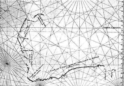
(No. 5) The Course of the Duyfken Applied to a Modern Map.
{Page 38}
The "great river" through which Tasman could not make his way was Endeavour Strait.
The maker of the Duyfken chart was honest, even to the inscription. It states:--
This chart shows the track followed by, the yacht The Duijfien both on the outward and the homeward voyage when visiting the islands east of Banda up to New Guinea. But Guliguli on Cenam, and Ceram, etc. are done after the drawing of Abraham Francken, 1602, 20th April; and Nieuw Zelandt with the Gounangapi east of it had been sailed into by Jasper Janssen de Jonge.
The latter portion of this inscription is an obvious reference to the voyage of inquiry made by the Duyfken when she went to Ceram from Banda in April, 1602, under the orders of Wolphert Harmensz, with Schouten as captain; and to a voyage made by Jasper Janssen (or Jansz) to the Kumawa peninsula at the south-western end of New Guinea at some other date. Abraham Francken was probably a mate on the Duyfken in 1602. The name of Jasper Janssen appears again as chief merchant at Amboina in 1608; he was Lieutenant-Governor in 1610, and succeeded Frederik de Houtman as Governor of Amboina in 1611.[1]
The appearance on the chart of Ceram and Nieu Zelant (Kumawa peninsula), though not visited by the Duyfken on this voyage, is thus fully accounted for. The Gounongapi (gunung, mountain; api, fire) shown apparently as a reef or shoal is really an eye view of the volcanic range which lies above Triton Bay; while "marasichlandt," if intended to mean "marshy land," would be a correct description of Adi Island, to which it is applied.
The name "Os Papuas," given to the most northerly part of the coastline of New Guinea at which the Duyfken touched on the return voyage, has been altered to "Duyfkenslandt" on the Hessel Gerritsz map of 1622, and incorrectly transcribed as "Duyfken's Eylant" on the
[1) J. K. J. de Jonge: De Opkomst van het Nederlandsch Gezag, Vol. III., p. 397.]
{Page 39}
Janssonius map. The inscription on the Australian portion of the chart is: "Nova Guinea. All this coast is low land."
The only Duyfken place name that remains on the maps to-day is Cape Keerweer. It is surprising that, although the Pera and Arnhem carried a chart of this coast which must have been drawn after the Duyfken's voyage, not one name has been transcribed to the map of the Pera's voyage, and not one reference to Duyfken names appears in the Pera's log. On the other hand, four Duyfken names on the Australian coast appear on Tasman's map of 1644--Revier met Bosch, Vliege Bay, Visscher's (Vis) revier, and Cap Keerweer.
We must express our gratitude to Dr Wieder for the discovery of this chart, because, as he says, "before 1606 no map was drawn on which a real portion of Australia was put down from observations. All prior to that was from, conjecture." We have here, therefore, the first record of the history of our country, and I suggest that when opportunity offers, and if it still remains, we should endeavour to have a coloured copy made, to take its place in 'the Mitchell Library with the Tasman map of 1644 and with the copy of the Gerritsz map of the Pacific.
After the return of the Duyfken to Banda from Australia, we have no record of her movements until Paulus van Solt reports her at Amboina in March, 1607. In June of that year, the Sub-cargo, Jan Roossengin, was placed in charge of sea operations at Ternate by Admiral Matelieff, and the Duyfken was one of the vessels under his control. Early in the following year, however, the Portuguese came to the Moluccas in force, and Roossengin was forced to go to Amboina for aid. He joined the Delft there (on which Willem Jansz was captain), and in a letter written on that vessel on May. 8, 1608, he says he had a running fight with the Portuguese for five hours, during which' eighty shots were fired, (at the Duyfken), but they did not do any damage.
With the fleet of Admiral van Caerden they sallied forth from Amboina and put' the Portuguese to rout, and
{Page 40}
took the island of Makian. This was in June, 1608. Shortly after this engagement, the Duyfken seems to have met her fate. Captain Saris, the English Company's agent at Bantam, makes another entry in his diary:--"1608. The first of September arrived a small pinnasse of the Flemmings from Mackian, by whom we understood of two ships called the China and the Dove (Duyfken) were cast away, riding at anchor afore Mackian."[1]
And, to place all doubts at rest, Jacques le Hermite, Chief Merchant at Bantam., wrote to the Directors at Amsterdam in November, 1608, reporting the success of Admiral van Caerden at the Moluccas, and added:--
"The Duyfken is burst in the doubling,[2] so that it was necessary to send some ships thither with food and other things."[3]
Jan Roossengin afterwards returned to Holland, but he was back in the Indies in 1611. He was merchant at Tidore in February, 1613, and spent the next five years fighting galleons, capturing junks, wrecking and being wrecked, up and down the archipelago from Manila to, Macassar. His ship, the Roode Leeuw (Red Lion), on July 29, 1617, broke its anchors and "went on the wall." He spent his breaks on shore signing documents for Governors-General Reael and Coen, as "fiscal representative," but after March, 1618, he fades from history. Although as sub-cargo Jan Lodewycksz van Roossengin was the superior of Captain Jansz on the Duyfken voyage, he did not remain so long in the company's service, and does not figure with the same prominence in Dutch colonial history[4]
On the Hessel Gerritsz Map of the Pacific of 1622 he is given pride of place: "...coast from 9 to 14 degrees sailed into by J. Rosingen," and "...the continuation of that which is here called Nova Guinea sailed into by Jan Rosengein A.D. 1606."
[1) Purchas His Pilgrimes (1625), Vol. I., p. 387.]
[2) Doubling: the lining of extra planks in a doubled ship.]
[3) J. K. J. de Jonge: De Opkomst van het Nederlandsch Gezag, Vol. 3, p. 253.]
[4) Career of Jan Roossengin abstracted from L. C. D. van Dijk: Twee Tochten naar de Golf van Carpentaria.]
{Page 41}
Having traced the outline of the career of Willem Jansz for a few years prior to the voyage to Australia, it is perhaps appropriate that I should relate what is known of his subsequent career. For this I am entirely indebted to an interesting monograph by Pieter Arend Leupe, Willem Jansz of Amsterdam and Willem Jansz of Amersfoort, which has never been printed in English. So far, Willem Jansz has never been anything but a name to us. Now it will be seen that he became a man of great distinction, that he made a second discovery of the shores of Australia, and that he rose to the rank of Admiral.
Leupe was in a particularly good position to ascertain the facts, as, after a long career in the Netherlands army, from which he retired with the rank of Major, he was appointed to a position in the Rijksarchief in 1863, and remained there until his death in 1881. He thus had access to original documents, and his work, which is highly regarded and frequently quoted by Dutch historians, is therefore of particular value. The paper from which I have prepared this summary was written in 1872, and it may be that additional matter, not yet published, has come to light.
Very soon after the return of the Duyfken from Australia, Willem Jansz left that vessel and appears to have gone to Bantam.
On October 5, 1606, Captain Saris made another entry in his diary. It read:--
"The West Frisland arrived here from Ternata; whence she was beaten by the Spaniards: she was not above halfe-laden with mace, cloves, and cotton-yarne."[1]
Jansz was given command of the Westfriesland, to take her home to Holland. He met with misfortune, however, on the voyage, for the Westfriesland had to be abandoned at Mauritius, and Jansz was obliged to return to Bantam. When Admiral Matelieff arrived there on November 24, 1607, he sent Jansz on the Madagascar with secret instructions to Banda to forestall the English ships
[1) Purchas His Pilgrimes (1625), Vol. I., p. 385.]
{Page 42}
under Captain Middleton which were reported to be on their way there.
Jacques le Hermite, writing to the Administrators on January 26, 1608, stated that:--
"The yacht Madagascar was loaded...and sailed on December 4 for Amboina and Banda in order to give notice of the arrival of two English ships at Bantam. Willem Jansz, formerly captain of the Westfriesland, was placed on her as captain.
Governor Houtman, of Amboina, writing to Hendrik van Bergel, merchant at Banda, on January 2, 1608, said that he had received a letter from "the Admiral Matelieff arrived by the yacht Madagascar, on which the captain is Willem Jansz, formerly of the Duyfken." Houtman and Bergel both knew Jansz as captain of the Duyfken, and this proves that Jansz of the Duyf ken and Jansz of the Westfriesland were one and the same man.
Having fulfilled his mission, Jansz returned to Amboina, where he was given command of the yacht Delft (April 20, 1608), with Jan Roossengin on board, and, under Admiral Pouwels van Caerden, took part in the capture from the Spaniards of the Island of Makian. Van Caerden wrote very highly of him, and Jansz, whose term of service had expired, was engaged for a further term and given command of the Eendracht. He was sent on important missions on this vessel to Achin (Sumatra), Ceylon and India (October 15, 1609). While on the way to Ceylon he fought and captured from the Portuguese a new ship which had come from the coast of Bengal, with a cargo mainly of sugar.
On the return of Jansz to Bantam, at the end of 1610, his longing to return home got the upper hand. He was therefore signed on the Orangie as Chief Merchant, sailed from Bantam on January 11, 1611, and reached Zeeland on August 23. The Chamber of Zeeland thought highly of his services, as is shown in a letter in which they described him as
"a very competent and sober man, who has pleased us greatly by his account of trade in the East, and it would be well if the Company had many such servants, when it would be more likely that the government would be better than we sometimes hear."
In endorsement of their good opinion, the Chamber signed Jansz on again for three years at 100 guilders a month,
{Page 43}
and on December 29 he sailed again for the Indies in command of the Orangie. With the fleet went also a yacht named the Duyfken, a new vessel. The Duyfken was ever a popular name for a small Dutch ship.[1]
The Orangie took part in various cruises against the enemy until she had her mast shot off near Ternate, and retired to Amboina. Refitted, she took in cargo and returned to Bantam, when Governor-General Pieter Both, the first Governor-General of the Dutch East Indies, had alarming news from the island of Solor, centre of the sandalwood trade from Timor and other islands. The natives of this island, which had been captured from the Portuguese some time before, had risen in insurrection through the influence of some Portuguese who had been allowed to remain, and murdered the Governor and several others.
Jansz was immediately sent to Solor with a force to restore order, with a commission as Governor, Both justifying this unusual appointment because of extreme urgency and explaining that Jansz "was by nature mild, modest and unassuming, who had acquitted himself properly during his time on the Orangie, and never had the slightest trouble with his crew, and always maintained order on his ship."
[1) For the spelling of the name "Duyfken" (Little Dove), I have searched every page of Vols. 2 and 3 of de Jonge's De Opkomst... in which is reprinted the text of contemporary documents from the Dutch East Indies archives, and found that the name was spelt in eight different ways--in one case, four different ways in the one (lengthy) document. In order of frequency the spellings are:
Duyfken (12), Duyfke (7), Duyffken (4), Duyffgen (4), Duyfgen (4), Duifje (1), Duifke (1), and Duijfje (1). The forms Duyfken and Duyfke alone are used throughout the period 1595 to 1608, that is, from the first voyage to the last. In no case did I find Duifhen (frequently used by English writers), and the form Duifken appears only in Heeres's text. The copy of the original chart herein referred to is the only place in which the form Duijfien is used. The latest and best authority is the Linschoten Society, and in Tresoor der Zee--en Landreizen..., by D. Sepp (1939), which is an encyclopaedic index to the first twenty-five volumes of that Society's publications, the form used is Duyfken for all references.]
{Page 44}
Willem Jansz quickly put things in order at Solor, but the following year Director-General Jan Pieterzoon Coen decided to abandon the fort on Solor, not to give up the Timor trade, but to conduct that trade from Amboina or Banda.
In June, 1616, Jansz's term of service had again expired, and he decided to return to Holland, although Governor-General Reael wished to retain his services. He was given the position of Chief Merchant on the Zeelandia, and reached Zeeland on June 30, 1617. By this time, however, the homeland had lost its attractions. Possibly. his friends and relatives had become scattered. during his years of absence, and he again accepted an engagement in the company's service as Upper Clerk and Merchant at 150 guilders a month, to be engaged in the first vacant position as Vice-Governor or as Commander on water.
On January 4, 1618, therefore, Willem Jansz set sail again for Java as Supercargo on the ship Mauritius, with Captain Lenaert Jacobsz. When they arrived. at Bantam on August 22, Jansz reported that on July 31, in 22 degrees south latitude, they had discovered an island and had landed there. For the second time, Willem Jansz had made a discovery of part of the Australian coast. The log of the ship has not been found, but the letter of Jansz reporting the discovery fortunately remains, and is here reproduced. Thus we are able, by a piece of extraordinary good fortune, to present a copy of a letter written by the man who first discovered Australia. The first portion of this letter reads as follows:--
"(Letter of Supercargo Willem Jansz to the Managers of the Amsterdam Chamber, October 6, 1618.)
"Worshipful Wise Provident Discreet Gentlemen.
"The present serves only to inform you that on the 8th of June last with the ship Mauritius we passed Cape de bon esperence, with strong westerly winds, so that we deemed it inadvisable to call at any land, after which we ran a thousand miles to eastward in 38 degrees southern latitude, though we should have wished to go still further east.
"On the 31st of July we discovered an island and landed on the same, where we found the marks of human footsteps: on the west side it extends N.N.E. and S.S.W.; it measures 15 miles in length, and its northern extxremity is in 22 deg. S. lat. It bears S.S.E."
{Page 45}
(No. 6) The Letter of Willem Jansz, October 6, 1618.
[1) Translation from J. E. Heeres Part Borne by the Dutch..., p. 12.]
{Page 46}
Jansz, in this letter, has obviously described the peninsula on the coast of Western Australia from Point Cloates to North-West Cape. The deep Exmouth Gulf, which he probably entered in a boat, would no doubt lead him to believe the peninsula to be an island. Soon after the discovery, the name of Willems River appeared on Dutch maps, being first shown on Hessel Gerritsz's map of 1618-1628. While it is impossible to locate Willems River with any certainty, Dutch historians claim that it is the Ashburton, but after a close examination of a modern chart I am inclined to the opinion that it was an opening to the Exmouth Gulf.
The last portion of the letter relates that the Mauritius lost forty-one men from scurvy, and advises the managers of the company in Holland what goods were required to be sent out to the Indies.
Immediately after his arrival at Bantam, Jansz was transferred to the Wapen van Amsterdam, and was called into consultation by the Council of the Indies.
The English in the East were now becoming formidable rivals. They frequently offered better prices for spices and bought cargoes that the Dutch had hoped to secure. The secret mission of Jansz to Amboina and Banda, for example, had been to buy up all the spice cargoes in sight so that there would be none left when Middleton's ships arrived. The native grandees watched this competition with great satisfaction, and played the rivals--Portuguese, English, and Netherlanders--against one another. There had never been anything but active hostility between the Dutch and the Portuguese—Spanish combination they usually attacked one another at sight. Now an armed conflict between the Dutch and the English was imminent. The most forceful personality who had ever come to the Indies was now Governor-General--Jan Pieterszoon Coen--and, spread all over the waters of the island groups, the Dutch had the strongest force of armed merchantmen in the Indies. At Jacatra, east of Bantam, the English and the Dutch had built batteries facing one another, and their vessels were skirmishing, with occasional shooting matches.
{Page 47}
(No. 7) Gerritz's Map of Western Australia, 1618-1628.
{Page 48}
Governor-General Coen, outnumbered at Jacatra, went off to the Moluccas for reinforcements. Jansz, with his wide experience and his acknowledged seamanship, was an invaluable man at this stage. On March 23, 1619, he was made a member of the Council of the Indies; Pieter de Carpentier,. subsequently Governor-General, and after whom the Gulf of Carpentaria was named, was made a member of 'the Council at the same time. Coen returned to Java with a fleet which included Jansz, and on May 23 attacked Japara, which, though well fortified, was captured and burnt. Coen then sailed west to Jacatra with sixteen vessels and 1200 men, and on May 30, 1619,. relieved the fort and captured the town. Upon its ruins Coen established Batavia and Dutch dominion in the East Indies.
Jansz, who took part in these operations, was then sent with six ships to the west coast of Sumatra, and on October 11 fell in with four English ships--the Dragon, the Beer, the Expedition, and the Rose. The English were taken completely by surprise. They had been busily engaged loading cargo; the men were tired out, and bags of pepper cluttered up their guns. Jansz laid two of his ships against the English flagship, and took it after a brief but fierce conflict, in which thirty Englishmen were killed and Captain Bonner mortally wounded. Finding resistance useless, the other three ships were surrendered. Jansz returned the Rose to enable his prisoners "to go elsewhere," and, with his three prizes, returned to Batavia. For this exploit the Council, on December 20, 1619, presented him with a gold chain worth 1000 guilders.[1]
Three months later, instructions were received from Europe that a treaty had been arranged between the English and the Dutch, under which a joint governing Council was to be formed, an Anglo-Dutch fleet of twenty sail was to be provided for mutual defence (and offence), and arrangements made for a division of the trade.
[1) Purchas His Pilgrimes (1625), Vol. I., pp. 639 and 661-2, gives accounts of this action, in which Jansz is described as "William Johnson, Commander of the Dutch Fleet," and, at p. 641, Captain Pring records a meeting with "Master Johnson."]
{Page 49}
Coen was furious. He wrote sarcastically to his Council in the Netherlands: "The British have voluntarily retired from the Indies and you have been so kind as to open the door to them again." Nevertheless, he obeyed his commands, but privately resolved that he would pursue the course that suited his own policy.
On May 28, 1620, the combined Council sent a fleet of ten ships to Manila and Japan "to protect the trade and do harm to the enemy." Under the treaty, the English were to fly the flag at the mainmast and the Dutch at the foremast. This further infuriated Coen. He wrote to his Directors:--
"The English have appointed a captain named Robert Adams as commander of their five ships and as Admiral of the fleet; we have appointed as commander of our five ships and as Vice-Admiral, the Honourable Willem Janssen, Councillor of India; it follows that the lesser shall command the greater, which is not right."
However, Jansz received these instructions:--
"Your Excellency is commanded to keep good friendship and agreement with the English nation and to help them (should anyone be in need) to the utmost of your power."[1]
The expedition was scarcely a success. It blockaded Manila and took a few ships, but the Dutch share of the booty was only 63,817 guilders. The combined Council, however, decided on a second expedition. This time, Willem Jansz went as Admiral and Robert Adams as Vice-Admiral. The news came to the ships at Firando (Japan), where Jansz was installed with naval honours on August 19, 1621. Manila was again blockaded in December. From then until June, 1622, the campaign continued against every ship that was not English or Dutch, so that when they counted up the spoils in July the Dutch share was 262,912 guilders, a much better result than the first.
The English were unwilling to engage in a third expedition, and Jansz was thus left in full control of his fleet. By the end of 1622 he was back in Batavia, taking
[1) See also E. S. De Klerck: History of the Netherlands East Indies, Vol. I., p. 228.]
{Page 50}
his seat again on the Council of the Indies. His engagement was extended for another three years at 250 guilders per month.
In October, 1623, Jansz was appointed Governor of Banda, where, on December 11, he was installed by public proclamation. He was to remain there for three and a half years. His duty was to promote agriculture, to place the schools and church on a good footing, to uphold the law, and to put an end to the disorder into which some of his predecessors had allowed the administration to drift. The lands were divided into plots and given to people in areas sufficient for the support of a given number of souls after the manner of loans--evidently a form of leasehold. The church council was able to write with appreciation of Jansz's administration, stating that the church services had progressed, especially with the schools, "which on our recommendation have been improved steadily and diligently over the islands, so that with time considerable good is to be expected from them."
In order to increase the interest in the schools and to gain the necessary funds, Jansz made use of the lotteries so much in vogue even in those days. In his Journal he wrote on May 8, 1625:--
"Began to give out the lottery, which is set up for the schools in the Banda Islands, in which a soldier of Denner named Guillaume Commeville gained the highest prize (being a golden cup)."
There was a shortage of labour--most of the original Bandanese having been wiped out when Coen conquered the islands--and Chinese, as well as Malayans, were brought in to work the plantations. The Governor encouraged the free people to trade with the Kei and Aru islanders after the slaves from those islands had returned.
The life on land, however, was beginning to pall. Jansz made several requests to be relieved, and at last a successor, Dr Pieter Vlack, was appointed, and Jansz returned to Batavia on June 23, 1627.
{Page 51}
Within two months he was on the high seas again, as Admiral of a fleet of eight armed ships, bound for the coasts of India. This was a diplomatic mission to enable Commissioner van der Lee to establish good relations with the Indian Rajahs.
One of Jansz's vessels was the Gulden Zeepaert, which had arrived at Batavia on April 10 after having sailed along the southern coast of Australia for over 1000 miles beyond Cape Leeuwin. The skipper was then Francis Thyssens, and he had on board the Honourable Pieter Nuyts; hence we get the names of the Islands St Francis and St Peter at the eastern end of the Great Australian Bight, and Nuyt's Land on the older maps. The Gerritsz chart, 1618-1628, states that the discovery was made on January 26, 1627--Australian Anniversary Day, it will be noticed!
Jansz was absent on the voyage to India from August, 1627, to June, 1628.
Two months later the Sultan of Mataram, who "cherished a design to snatch Batavia from the Dutch, conquer Bantam, and become Lord of all Java," secretly prepared to take the town. Here, Jansz played his part in organizing defences; "he stood by Coen with counsel and deed." But the time had come for him to retire--he was getting old--and as some ships were ready for sailing, he decided to go home.
On December 3, 1628, Governor-General Coen gave a banquet to which all the principal officers were invited, and Jansz, with two other Councillors, Le. Febvre and van Gorcum, said farewell to the Indies.
Next day he hoisted his Admiral's flag, raised the anchor, and late in the afternoon sailed out of the roadstead of Batavia with the land wind.
On July 16, 1629, Admiral Willem Jansz went to The Hague to report on the state of the Indies to the States General, the Army, and to His Princely Excellency; and, that duty done, ended his long career with the United East India Company.
{Page 52}
(No. 8) The Carpentaria Coastline
(a) Modern Map. ((b) The Duyfken Chart. (c) The Tasman
Map.
{Page 53}
Of Jansz nothing further is known. We know nothing of his beginning; we know nothing of his end. We know only that he was a gallant seaman who served his country and his company with honour and success for over thirty years; that he rose from the position of steersman of a vessel to. the Admiralship of the Fleet; that he was Commander of Solor, and Governor of Banda, at that time one of the most important colonial possessions of the Netherlands; that he was a brave enemy when it was his duty to fight against us, and an honourable friend when he fought on our side; that he was a member of the Council of the Indies; that he twice visited and landed on the shores of Australia, and, retiring after a life full of activity and achievement, died before it could be realized that he was the first man to discover an island-continent which slumbered peacefully in the southern seas for another 164 years until Captain Cook found its eastern coast and added it to the possessions of the British Crown.
(1) A Dutch Ship of the Duyfken Type and Time.--This drawing is from Henry B. Culver's The Book of Old Ships (New York, 1924), and represents the Halve Maen, in which Henry Hudson, an English navigator in the service of the Dutch, sailed up the Hudson River (New York State) in 1609. The Halve Maen was a Dutch "yacht" of the same type and size as the Duyfken, carried the same number of men, and was afloat at the same period. A full-sized replica of this vessel was presented by the Dutch people to New York on the occasion of the 300th anniversary of Hudson's discovery. There is no authentic picture of the Duyfken available, but contemporary prints give a good idea of the appearance of the vessel.
(2) The Four Vessels of the Dutch 'First Fleet.--This illustration was reprinted in De Eerst Schipvaart, Vol. II. (Linschoten-Vereeniging, The Hague, 1925), from an engraving dated 1611.
(3) Hessel Gerritsz's Map of the Pacific, 1622.--This map of the Pacific Ocean, the south-western section of which is here reproduced, is the first map to show any part of Australia, being that portion of Cape York Peninsula discovered by the Duyfken in 1606, described on the map as "Nueva Guinea." It also shows a space between Australia and New Guinea, though the Dutch at that time were not certain that Torres Strait existed. The illustration is from the Mitchell Library coloured facsimile of the original, which is in the Depot des Cartes de la Marine, Paris.
(4) The Duyfken Chart.--This is from the copy in Dr. F. C. Wieder's Monumenta Cartographica (The Hague, 1933).
{Page 54}
(5) The course of the Duyfken applied to a modern map.--The course of the Duyfken on the voyage of discovery to and from Australia and Banda is here applied to a map of the Indian Ocean from the National Geographic Magazine (Washington, D.C.). Some emendations have been made for the sake of clarity.
(6) Letter of Willem Jansz, 1618.--This letter is in the National Archives at The Hague. (Mitchell Library photostat.)
(7) Gerritsz's Map of Western Australia, 1618-1628.--This shows the western and southern coasts of Australia accidentally discovered by the Dutch when sailing from the Cape of Good Hope to Java between 1616 and 1628. It does not include the discoveries in the Gulf of Carpentaria by the Duyfken (1606) and the Pera and Arnhem (1623). Willem's River, the location of the second landfall of Willem Jansz on the coast of Australia, appears on the map between Eendracht Land (1616) and De Witt's Land (1628). The illustration is from the reproduction in J. E. Heeres' Part Borne by the Dutch in the Discovery of Australia.
(8) The Carpentaria Coastline.--Three illustrations of the portion of the western coastline of the Cape York Peninsula discovered by the Duyfken as shown on (a) the Queensland State Map, No. 2b, 1931; (b) the Duyfken chart; and (c) Swart's copy of Tasman's map.
Modern Map.                Duyfken Chart.          Tasman Map.
Coral reefs near
Deliverance Island         Vuyle Bancken              --
Prince of Wales Island    't Hooghe Eijlandt          --
Jardine River                    --                waeter plaets
   --                      Moent                       --
   --                            --                Staeten revier
Batavia River                    --                Prince revier
Pennefather River          R.met het Bosch         Revier met bosch
Albatross Bay              Vliege Baij             Vliege Bay
Watson and Archer Rivers   Dubbelde Ree            revier coen
Dugally River              R. Vis                  Visschers revier
Cape Keerweer              Cabo keerweer           cap Keerweer
NOTE.--Tasman did not make a close examination of the coast visited previously by the Duyfken, the Pera and the Arnhem, but placed on his map, somewhat indiscriminately, the names given to the coast after the voyages of those vessels. The Revier Carpentier was mentioned 'in the Pera's Journal, but was altered to De revier Batavia on the Pera's chart; on Tasman's map, it appears to be a river flowing into Vliege (Albatross) Bay--an obvious misplacement.
All illustrations are from the collection in the Mitchell Library, Sydney, with the exception of the drawing of the ship of the Duyfken type, which is from Culver's book in the Public Library of New South Wales.
{Page 55}
For the material perused during the preparation of this paper, I have drawn entirely on the rich resources of the Mitchell Library, Sydney. To Miss Ida Leeson, Mitchell Librarian, and her staff, I tender my thanks for their ready co-operation at all times. My summary of the career of Willem Jansz is from the monograph, Willem Jansz of Amsterdam and Willem Jansz of Amersfoort, by P. A. Leupe, the first portion of which was translated for the first time into English by Miss Phyllis Mander Jones, Bibliographer, Public Library of New South Wales, whose scholarly assistance with this and other translations and searches I acknowledge with gratitude. For other help in translations I thank Mr Hendrik van Dugteren, of Coogee.
This site is full of FREE ebooks - Project Gutenberg Australia